- 1School of Architecture, Chang’an University, Xi’an, Shaanxi, China
- 2School of Civil Engineering and Architecture, Xi’an University of Technology, Xi’an, Shaanxi, China
The ancient City of Xi’an has a history of more than 7,000 years of civilization, more than 3,100 years of City development, and 1,100 years of capital construction. With the gradual development of urban areas, the number of imperial tombs in Xi’an has reached 72. These mausoleums are large in scale and valuable, yet they are influenced by the rapid development of present urbanization, cities, and mausoleum spaces. The development contradictions between cities and mausoleum spaces progressively become prominent and need to be handled urgently. This article utilizes spacetime as the base scale, GIS spatio-temporal analysis, field research (including aerial photographs of unmanned aerial vehicle (UAV) in the 8 years, 2015–2022), and Pearson analysis to explore the temporal and spatial evolution law between Xi’an’s urban space and the 55 mausoleums dominated by emperors of various dynasties. It was concluded that the nuclear density area distance layout of Xi’an City and the mausoleum is closely related to time and space. Since ancient times, there has always been a relationship between the Spatio-temporal development of Xi’an City and its mausoleums, and the nuclear density area distance layout of the mausoleums is intimately connected to the status and nature of Xi’an City. Currently, mausoleums are part of site protection. However, because of the large space of the mausoleum, the contradiction between the protection and utilization of mausoleum sites and the development of urban space is revealed. This paper hopes to provide urban planners and site protectors with ideas and data support for the Spatio-temporal development of cities and mausoleums and realize the integration of the protection and renewal of mausoleum sites into the path of urban design and planning.
1. Introduction
1.1. Urban spatial development of the ancient City of Xi’an
Xi’an has a history of over 7,000 years of civilization, 3,100 years of City construction, and 1,100 years of capital construction. In 1981, Xi’an was designated a “World Historic Cities” by UNESCO. Xi’an is also the most important of the four ancient capitals of China, with a long history, having experienced 13 dynasties building the capital, so there are many large sites. The Western Zhou, Qin, Western Han, Sui, and Tang dynasties were all located in present-day Xi’an (as shown in Table 1).
1.2. Overview of the space-temporal development of the ancient City of Xi’an and the mausoleum
Time and space come down in one continuous line, time is to space what fluid is to the container, and the symbiotic relationship between space and time has historical significance and cultural connotation. The current study aims to discover the evolution of the temporal and spatial relationship between the ancient City of Xi’an and the mausoleums dominated by emperors of various dynasties (Yang and Yanfei, 2020). Nevertheless, there are significant restrictions to the current research, and the traditional concept of time is disregarded in the space building between the City and the mausoleum. What is the important point here is that time and space have always been in a twin relationship during the construction and development of the relationship between ancient Chinese cities and mausoleums. Varied time marks with great local characteristics and protection value are projected in space (Kane et al., 2014). Therefore, it is necessary to continue research based on existing research in constructing and developing the concept of time and space between them. In general, ancient Chinese dynasties chose mausoleums near the City for their kings and emperors.
1.3. Problem statement and ojective
The ruins of Xi’an’s ancient City are extremely valuable. Notwithstanding, as time and distance pass, the conflicts become more apparent as urbanization progresses, and the urban problem must be addressed immediately.
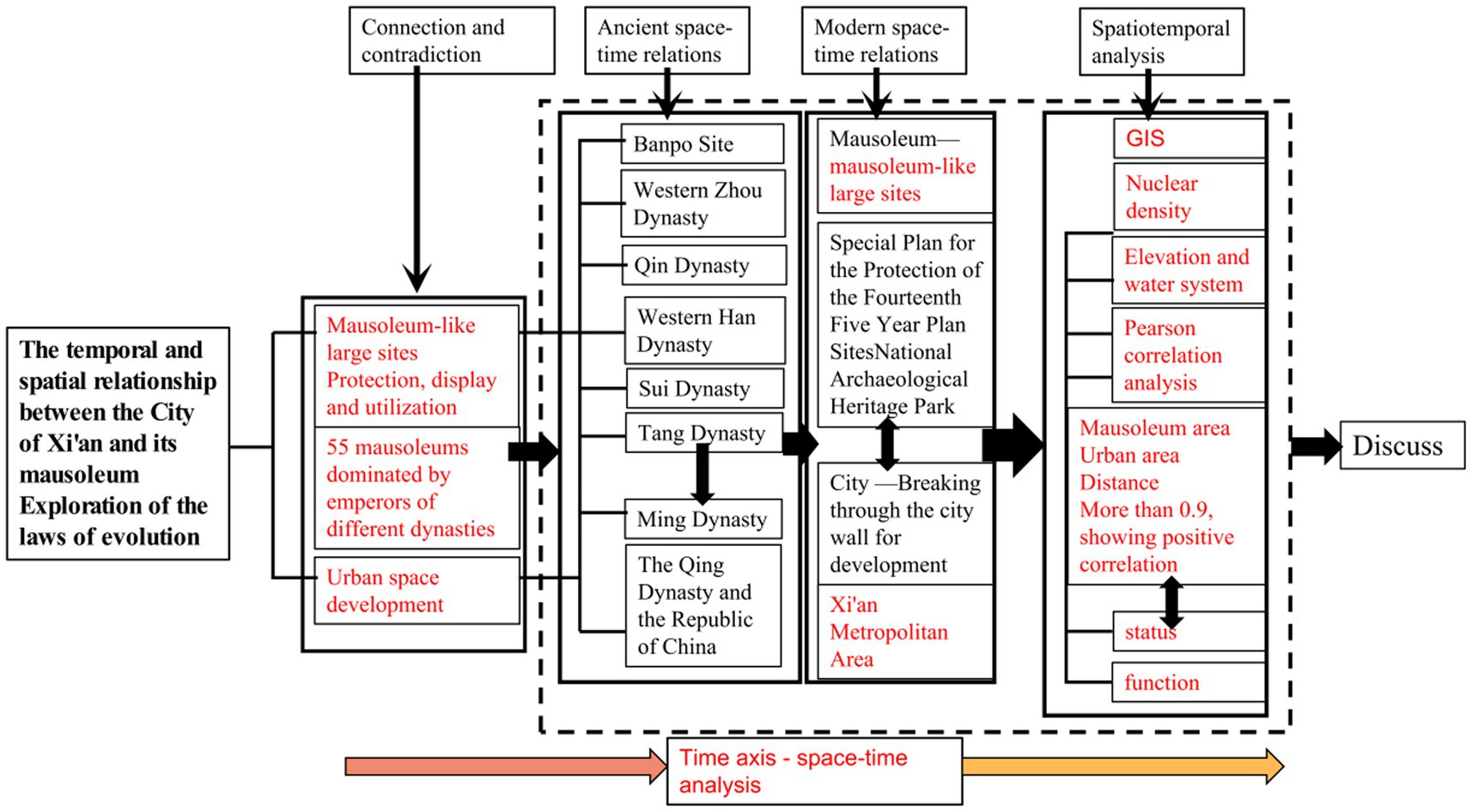
Therefore, this article aims to explore the evolution of the temporal and spatial relationship between the urban area of ancient Xi’an City and the shrines dominated by emperors of various dynasties and explore studies on the conservation and renewal of large mausoleum sites in the path of urban design and planning. Thus, the mausoleums will adapt to the development of the urban space, and the perspective of the “combination of the City and the mausoleum” will be realized (Frame shown in Figure 1).
2. Materials and methods
2.1. Object selection
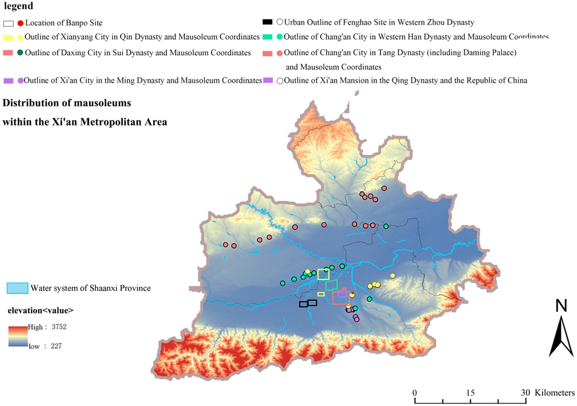
In this article, 55 imperial mausoleums in the ancient City of Xi’an have been selected to show the dynasty in chronological and spatial order. Generally, the emperors and emperors of ancient Chinese dynasties located their mausoleums near the capital. According to the order of time and space, this paper selects 55 imperial mausoleums of representative dynasties in the ancient City of Xi’an for overview (as shown in Figure 2).
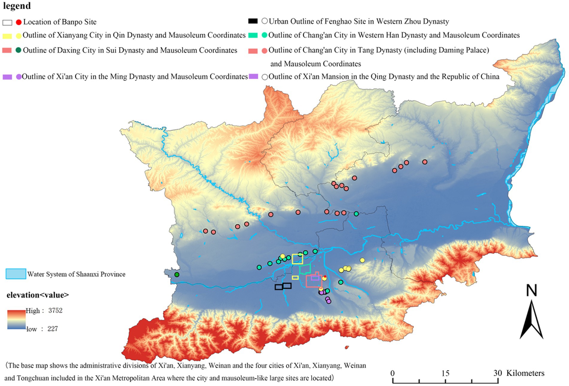
Figure 2. Overview of the Spatio-temporal development of the ancient City of Xi’an and the mausoleum. (Source: Author draws with software).
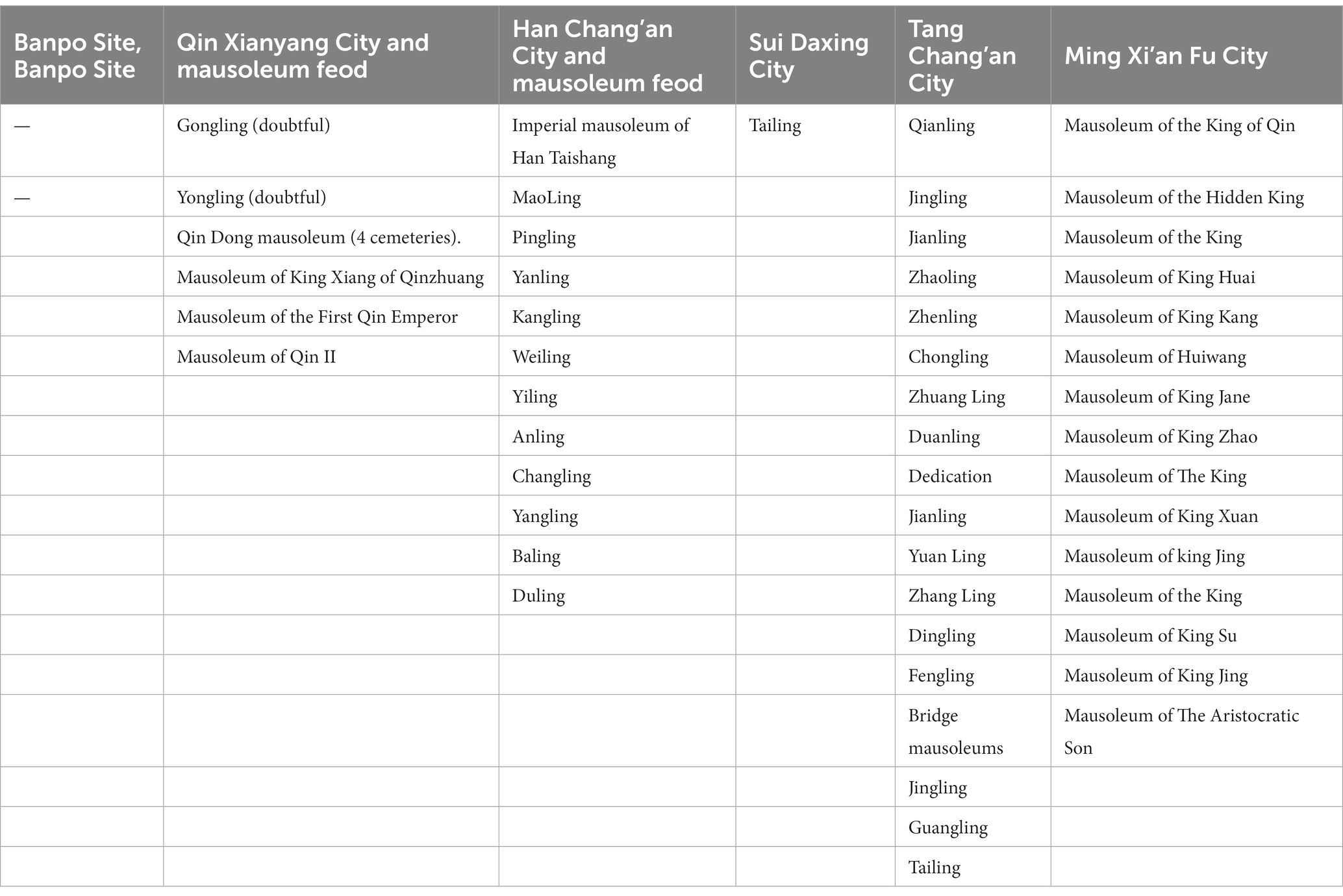
Banpo, Fenghao, Qin Xianyang City, Han Chang’an City, Sui, Tang Chang’an City, Ming Xi’an Fucheng, and other City sites developed in the ancient City of Xi’an and the corresponding Banpo, Western Zhou, Qin, Western Han, Sui, Tang, Ming, and other dynasties were the 55 imperial mausoleums or mausoleums selected objects of study (as shown in Table 2).
2.2. Research methodology
This paper used time and space as the scale to explore the Spatio-temporal evolution relationship of urban space and its mausoleum. GIS Spatio-temporal analysis, field research (including drone aerial photography), Pearson correlation coefficient, and other methods were used.
1. The spatio-temporal visualization of the ancient City Xi’an urban space and its mausoleum was carried out using ArcGIS10.8 (Changsong et al., 2021). The relevant data acquisition and processing steps are as follows: Data acquisition and Data processing.
Data acquisition. Xi’an Digital Elevation Model (DEM) data of the ancient City is downloaded from the geospatial data cloud platform, and water system roads are extracted from DEM data. From the Gaud map, the geographical coordinates of the mausoleum can be accurately obtained through location search, and finally the effective data of the coordinates of 55 mausoleums can be obtained (these are from the API system of Gaude Map), and the distance from the mausoleums to the spatio-temporal cities is measured by the Gaud map.
Data processing. In order to avoid the deviation of the research results, the data are uniformly projected into the World Geodetic System (WGS84) coordinate system for nuclear density and other related analyses. At the same time, Google Map coordinate verification and manual calibration are performed on the mausoleum coordinate data. After calibration, DEM and coordinate datas are placed on the same research platform to form a working base map.
The nuclear density analysis can reflect the large-scale spatial concentration and dispersion of mausoleums and the spatio-temporal relationship with cities under the accumulation of spatio-temporal relationships (Sichao and Hui, 2020). In the Kernel density analysis formula (Changsong et al., 2021) ( is the location coordinates of each mausoleum, n represents the number of mausoleums, h is the search radius, is the search radius, the search radius and the search radius h determine the estimation of kernel density).
Standard deviation ellipse (SDE) is a common method used to study the spatial directional distribution characteristics, which can accurately reveal the centrality, distribution, directivity, and other characteristics of the mausoleum spatial distribution (Daoping, 2022). Its basic principle is: Using 3σ. The standard deviation of the x coordinate and y coordinate is calculated, respectively, with the average center of spatial elements in the study area as the starting point to determine the axis of the ellipse. 3σ criterion out that in a two-dimensional coordinate system, one standard deviation ellipse will cover about 68% of the features, two standard deviation ellipses will cover about 95% of the features, and three standard deviation ellipses will cover about 99% of the features. The main parameters involved in this method are: The major axis and minor axis of an ellipse, the center of a circle, and the rotation angle. The major axis represents the distribution direction of spatial features. The longer the major axis, the stronger the directivity of spatial characteristics; the short axis symbolizes the spatial element distribution range. The longer the short axis is, the wider the distribution range of spatial elements will be; the center of the circle represents the position of the center of gravity of the space feature; the rotation angle represents the angle formed by clockwise rotation from the real north direction to the major axis of the ellipse. The area of the ellipse indicates the concentration degree of the spatial element distribution. The smaller the area, the higher the concentration degree.
2. The UAV aerial photography survey used DJI air2s type UAV.
3. Pearson’s correlation coefficient is widely used in natural and social sciences studies to indicate the correlation between two variable questions (Sichao and Hui, 2020). Pearson’s correlation coefficient was used to calculate the correlation between various physical geographical and sociocultural elements and the distribution of traditional villages. Pearson correlation coefficient ranges from −1 and 1. If y > 0, it indicates a positive correlation; If y < 0, it indicates a negatively correlated. An absolute value >0.7 indicates a very high correlation, an absolute value between 0.4 and 0.7 indicates a moderate correlation, an absolute value of 0.2–0.4 indicates a low correlation, and an absolute value <0.2 indicates a very low correlation.
2.3. The evolution of Spatio-temporal relations in the republic of China
2.3.1. Banpo site (about 5000 B.C.–4500 B.C.)
The Banpo site has a history of more than 6,000 years. Shaanxi Province, located on the east bank of the Xun River in Xi’an City, covers an area of about 50 square kilometers (Ling, 2016).
Zoning: The Banpo site has a full functional partition, divided into a residential area, a mausoleum area, and a pottery workshop area. The trenches separate these sections, and the outer trench serves as a defense. An artificial trench also surrounds the residential area. The site was divided into two residential areas by a small ditch, each with a large house in the center and surrounded by small apartments. Rectangular animal pens, urn burials of children, and earth pit mausoleums for small children were also discovered near the house; outside the ditch, a public cemetery to the north and a kiln area to the east were identified.
Distance: The distance between the City and the mausoleum begins to rise.
Scale: 50 square kilometers in total.
2.3.2. Western Zhou dynasty (1,046 B.C.–771 B.C.)
In the eleventh century BC, King Wu of Zhou destroyed the Shang, and the founding name was Zhou. After the Shang Dynasty, the Zhou Dynasty was the third in Chinese history to impose slavery. The dynasty lasted a total of 790 years. It can be divided into two periods: The Western Zhou Dynasty (1,046–771 B.C.) and the Eastern Zhou Dynasty (770–256 B.C.). The Western Zhou Dynasty set its capital at Haojing (now Xi’an).
Capital: The capital of the Western Zhou Dynasty (Shiwu et al., 2021), Fengjing, and Hojing are called “Fenghao.” The ruins of Fenghao are located in Xi’an, Shaanxi Province, on both sides of the Feng River in Mawang Street and Doumen Street in Chang’an District, Feng is in Hexi, and Pickaxe is in Hedong (Liang, 2016). Fengjing is on the west side of Feng River. Haojing is on the east side of Feng River.
Zoning: The ruins of Fenghao and Liangjing cover an area of about 17 square kilometers and are the ruins of a big capital City. The disparities in their separate social and economic activities can be classified as Duyi District, Wangling District, Agricultural Planting Area, Amusement Fishing and Hunting Area, and Pastoral Area.
Mausoleum distribution: The mausoleum area, identified as Biyuan, is a separate division of the Fenghao royal mausoleum area that represents certain dynasty privileges. According to the Tang epitaph, Biyuan is situated in the southern suburbs of Xi’an around Sanyao Village, which is in the southeast direction of Haojing (Liancheng, 1988).
Distance: Biyuan, according to the old site of Ho Kyo, is about 20 or 30 miles. The original surface here is high and flat, the soil is thick and deep, and it is suitable for early burial places and mausoleums.
Scale: City: Nearly 17 square kilometers.
Connection: The social and economic functions of the extended areas of Fenghao and Liangjing are determined by their unique natural environment and geographical conditions.
2.3.3. Qin dynasty period (Qin dynasty capital Xianyang 350 B.C.–221 B.C., Qin dynasty BC221 B.C.–206 B.C.)
The Qin Dynasty (Figures 3A,B) was the first unified feudal dynasty in Chinese history established by the Qin State during the Warring States period.
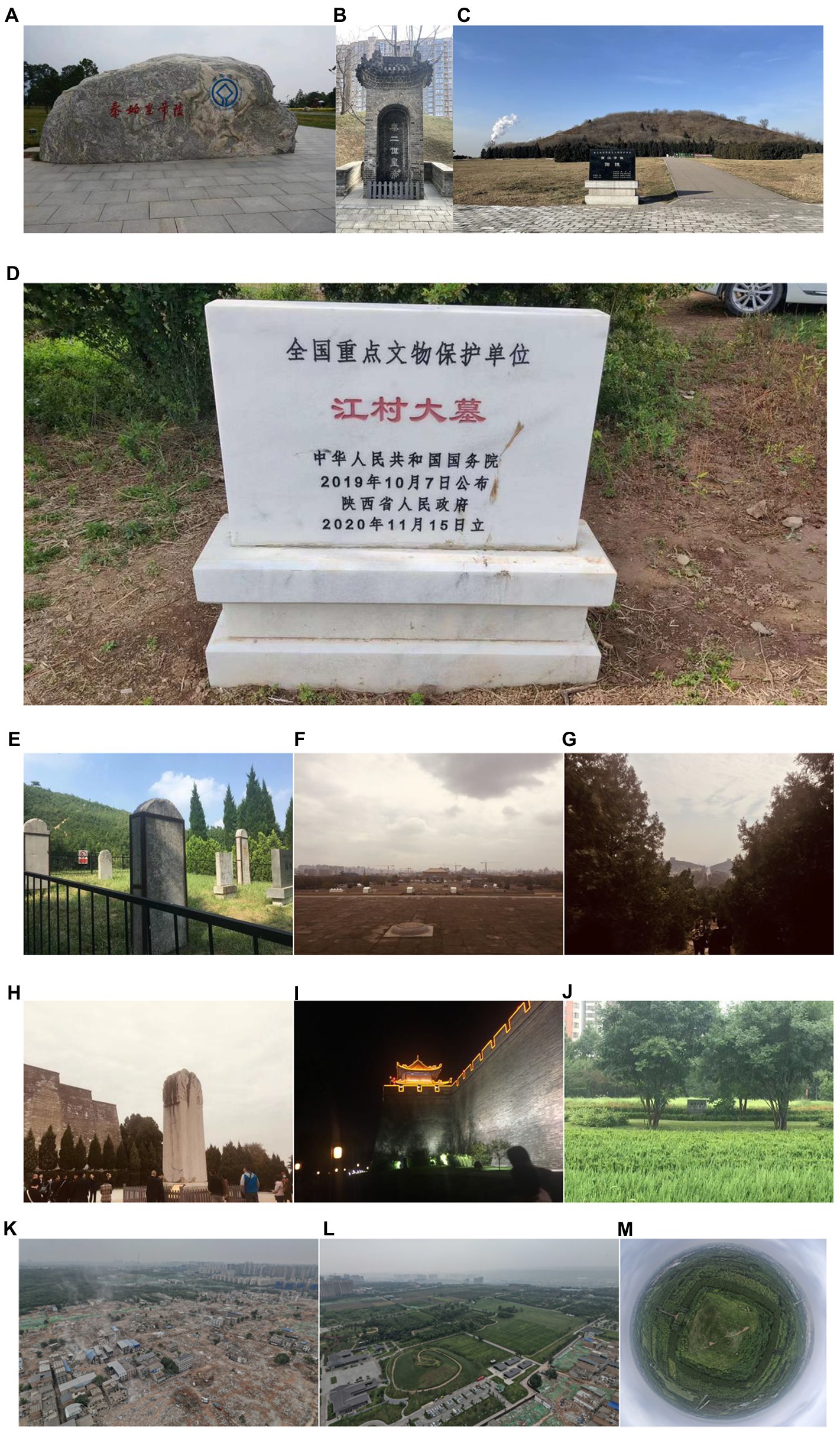
Figure 3. Survey of the City and mausoleums: (A) mausoleums of the First Emperor of Qin, (B) mausoleums of the Second Emperor of Qin, (C) mausoleums of the Western Han Dynasty, (D) mausoleums of Yang in the Western Han Dynasty, (E) mausoleums of Du in the Western Han Dynasty, (F) Daming Palace, (G,H) mausoleums of Qian in the Tang Dynasty, (I) Wall of the Ming Dynasty, (J) mausoleums of the descendants of the Emperor of Qin in the Ming Dynasty, (K) Aerial photos of the removal of Sanzhao Village around the mausoleums of Du, (L) Duyi Ruins Park, and (M) Spherical panorama of the mausoleum of Du. (Source: The author took the photo using a mobile phone and Dajiang Air2s UAV. The survey was conducted from 2015 to 2022.)
Capital City: The site of Xianyang City in the Qin Dynasty, built from the late Warring States Period to the Qin Dynasty, is located between Xi’an City and Xianyang City, covering both banks of the Wei River. The excavation area is 15.168 square kilometers, and the existing site is 20 square kilometers.
Mausoleum distribution: The distribution of small and medium-sized Qin mausoleums around Xianyang showed a trend of shifting from northwest to Chengdong to Badong over time. The distribution of small and medium-sized Qin mausoleums around Xianyang City showed a trend of moving from the northwest to the east of the City and then to the east of the Ba River over time; Beiban Mausoleum is the first phase, Zhiyang Mausoleum is the second phase, and Shihuang Mausoleum, Hansenzhai Mausoleum, and Shenheyuan Mausoleum are the third phases.
Layout: The ruins of Qin Xianyang City are located on the north bank of the Wei River in the form of a natural landform that gradually rises to the north and from south to north. Also, it is the beach on the north bank of the Wei River, the first-class terrace, and the second-level terrace (Wu et al., 2016).
Mausoleum of the First Emperor of Qin: Inside and outside are two rammed earth City walls that represent the imperial City and palace City of the imperial capital Xianyang. This mausoleum is located in the inner City’s south and is in the shape of a bucket, presently 51 m high, with a circle of more than 1,700 m at the bottom.
Scale: City: 20 square kilometers in existence; Mausoleum: The total area of the mausoleum of Qin Shi Huang (Figure 3C) is 56.25 square kilometers; The Eastern Qin Mausoleum is an essential part of the development of the Mausoleum of the King of Qin. It is located on the western foot of the Lishan Mountain hillside, with a total area of about 24 square kilometers.
Contact (Mausoleum feod): Qin pioneered the Mausoleum feod practice.
The Qin Dynasty Imperial mausoleums were primarily established to build the seven Imperial mausoleums.
2.3.4. Western Han Dynasty (202 B.C.–8 A.D.)
The capital of the Western Han Dynasty was located in the ancient capital of Chang’an (Xi’an) more than 2,000 years ago.
Capital City: Weiyang District, Xi’an City, is located where the site of Chang’an City during the Han Dynasty. In the Western Han, Dynasty, this City served as the country’s political, economic, and cultural center for more than 200 years. The total area of the site protection is 65 square kilometers, including 36 square kilometers of the City wall.
Distribution of Imperial mausoleums: There are 11 Imperial mausoleums of the Western Han Dynasty, nine in Xianyangyuan in Weibei and two in Bailuyuan in Weinan (Jiangcun mausoleum was identified as the mausoleum of Emperor Wen of Han in December 2021; Figure 3D) and Shaolingyuan (Duling, Emperor Xuan of Han; Figures 3E,K,L,M) are in a place with convenient transportation, high and open terrain, and good feng shui. Seven of them are located near the Mausoleum feod (Wenliang et al., 2021).
Layout: Chang’an City in the Han Dynasty has 9 urban areas, 160 lanes, wide and flat streets, and a neat layout. The street can be paralleled with 12 carriages. At its peak, the City has a population of about 300,000. Changle Palace, Weiyang Palace, and Jianzhang Palace are the three most famous palaces in the Chang’an City of the Han Dynasty (Ming, 2020).
Mausoleum: The emperor and queen are buried together in separate mausoleums under the Han Dynasty imperial mausoleum construction method, and the mausoleums are located to the east of the royal mausoleums. The grave mounds are far smaller than the imperial mausoleum (Xi and Ling-fu, 2012). Chang Mausoleum feod is located north of the Changling Cemetery, while the heroes’ mausoleums are east of the cemetery.
Size: City: 35 km2.
Mausoleum: The Han mausoleums are generally more than 10 square kilometers. Link (Mausoleum feod): Mausoleum feod, also known as Mausoleum County, is an administrative region formed by a significant number of individuals who migrated to live near the imperial mausoleum. It is an essential part of the imperial mausoleum (Xi and Ling-fu, 2012). As a particular administrative region, Lingyi existed in most Western Han Dynasty. It had a close relationship with Chang’an, the capital of the Western Han Dynasty, and had a profound impact on the social development of the entire Western Han Dynasty. The Mausoleum feod center is located in Mausoleum feod, which served as the national political center during the middle and late Western Han Dynasty. Du Mausoleum feod became another political center (Hang, 2016).
2.3.5. Sui dynasty (581 A.D.–618 A.D) and Tang Dynasty (618 A.D.–907 A.D.)
After the Sui Dynasty, the Tang Dynasty was the great unified Central Plains Dynasty in Chinese history. Capital City: Sui and Tang Dynasty Chang’an City was the world’s largest capital City at that time, with the most standardized planning layout and magnificent architecture. The land area is ~87.27 square kilometers (the new Daming Palace was built in the Tang Dynasty).
Distribution of imperial mausoleums: Fuping County, Pucheng County, Weinan City, Shaanxi Province, and Sanyuan County in Xianyang City, Shaanxi Province, all have Tang Dynasty imperial mausoleums. The six counties of Jingyang County, Liquan County, and Qianxian County were announced by the State Council as the fifth batch of national critical cultural relics protection units, including the mausoleum of the Eighteenth Tang Emperor in Guanzhong.
The Imperial mausoleums of the Tang Dynasty are majestic due to the mountains fan-shaped around Chang’an. Together with Chang’an City, they constitute the highest level and the most significant density of Tang Dynasty cultural site scenic spots in the country.
Layout: City: Chang’an City, erected during the Sui and Tang dynasties, was constructed using conventional Chinese architectural and planning principles. The City comprises Waiguo City, Imperial City, Miyagi City, Forbidden Garden, and Fang City. There are two cities and 108 fangs.
Zhaoling construction layout: It is modeled on the pattern of Tang Chang’an City, and the entire cemetery is composed of palace (Gong Cheng, the palace where the emperor lived), imperial City (Huang Cheng, the political authorities), and Waikuo Cheng (residential areas). Among them, Miyagi Castle is located in the mausoleum’s northern center, symbolizing where the emperor lived before his death. The Imperial City is located south of Miyagi Castle and symbolizes the Hundred Officials Office. Waikuo Castle is arranged in three directions, southeast, north, and south, guarding the Imperial City and Miyagi Castle; thus, Waikuo Castle symbolizes a residential area. Li Shimin’s mausoleum, Xuan Gong, is located at the bottom of the northernmost mountain peak of the mausoleum, which is consistent with the palace’s location in Chang’an 9 City (Ruikun, 2021).
Scale: City: About 87.27 square kilometers [Tang Dynasty new Daming Palace (Figure 3F)]. The Tang Zhaoling mausoleum area is even more exaggerated, reaching 200 square kilometers, ranking first in China, and challenging to find a match even on a world scale.
Connections: City: Traditional Planning Ideas and Architectural Styles; Mausoleum: defense of the north. Feng Shui considers the unity of heaven and man, and thus the mausoleum is often located against a mountain (Qianling as shown in Figures 3G,H). The scale is grand, reflecting the atmosphere of the Tang Dynasty. Prior Tang Dynasty, some imperial mausoleums—like the Duling mausoleums in Tang Chang’an City’s southeast suburb—became popular tourist destinations for locals to visit: Li Bai (Tang) South Dengdu mausoleums, North Looking at the Five mausoleums. Autumn water sets brightly, and the streamers extinguish the distant mountains.
2.3.6. Ming dynasty (Ming dynasty king Jianfan 1,370 A.D.–1,644 A.D.)
The mausoleum site of the Ming Qin King located in the Chang’an District of Xi’an is located in the Chang’an District of Xi’an; the Ming Qin King and the City of Xi’an have a mutually beneficial connection (Ruikun, 2021).
Capital: Xi’an City in the Ming Dynasty is the “post-capital era” in the history of Xi’an’s urban development. Xi’an’s status has gradually changed from a capital City to the center of the northwest region. Despite a decline in status, tremendous urban growth and economic progress have been seen during this period. This is inextricably linked to the Qin King’s roots in Xi’an. Besides, during this period, the spatial pattern of Xi’an City underwent three significant changes: (i) the northeastward expansion of Xi’an City in the early Ming Dynasty and the establishment of the Ming and Qin Royal Palaces (Bowei, 2017), (ii) the relocation of the Bell Tower, and (iii) the construction of Waiguan City. The urban axis and its spatial sequence in the Ming and Qing dynasties were significantly affected by this series of substantial changes (Figure 3I).
Distribution: The mausoleum of the Ming Qin King, located in Xi’an, Shaanxi, is the mausoleum of the 13th generation of qin clan families in the Ming Dynasty and was announced as the sixth batch of national critical cultural relics protection units on May 25, 2006. Taizu Zhu Yuanzhang established a domain in 1370, made Zhu Zhu the second son of the King of Qin and the crown prince, and founded Xi’an Province. Since the King of Qin was the oldest among the kings of the clans, he had the heaviest military power. Besides, he shouldered the weighty responsibility of defending the northwest frontier. The Qin clan state is known as “the first clan under the heavens,” as well as “the first clan, the head of the clan alliance.” The 274-year reign of the Qin Fan kingdom saw the deaths of 13 clan kings, one Shizi (Figure 3J), 16 princesses, and 38 county kings. A total of 68 mausoleums, magnificently constructed after their deaths, are scattered across the Shaoling and Fengqi Mounds in the region, from Mingli in the east to Sanyao in the west. The pavilions in front of the mausoleums were scattered, forming a complete royal cemetery.
The mausoleum of Zhu Shuang, the King of Qin in the Ming Dynasty, is located on the Duling Plain in the southern suburb of Xi’an. The luxurious architecture of Zhu Zhan’s mausoleum is no longer present. In front of the mausoleum, only fragments of glazed tiles in the colors of yellow and blue are scattered. The Shinto is located straight north of the Chinese table, adjacent to the southwest of the garden’s gate. Stone carvings of unicorns, tigers, sheep, horses, lions, and people are lined up from east to west, solemn and grand.
Scale: City: Circumference about 13.7 km; Mausoleum: The mausoleum of king Ming Qin is located northeast of Dafujing Village in present-day Duling Township, sitting north to south, with a circumference of 187 m, and the height of the current sealed soil is about 20 m (Estoque and Murayama, 2016; Bowei, 2017).
Status: In terms of urban development in Xi’an City, the Ming Dynasty represents the “post-capital age” in history. Xi’an’s situation has gradually changed from the capital to the center of the northwest region.
2.3.7. Qing Dynasty, Republic of China period (1,644 A.D.–1,949 A.D.)
Since no necessary mausoleums were constructed in Xi’an during this time, the City’s area is roughly the same as it was during the Ming Dynasty.
2.3.8. Spatiotemporal summary
The urban space of the ancient City of Xi’an and its mausoleum has a strong correlation between temporal and spatial, primarily in terms of partitioning, distribution, layout, distance, area scale, internal relationship, and urban status (as seen in attachment).
2.4. The evolution of modern temporal and spatial relations: Connections and contradictions
2.4.1. Process overview
Xi’an, one of China’s central cities, has experienced tremendous development; however, the preservation and utilization of large mausoleum sites contradict urban space development (Bin et al., 2020). The City’s spatial development has not been perfectly aligned with the significant ruins, which has become an urgent problem that needs to be rectified to achieve an inclusive, harmonious, and beautiful urban space and actualize the iteration of historical civilization and metropolitan region (De la Luz Hernández-Flores et al., 2017).
2.4.2. Changes in cities and mausoleums: Connections and contradictions coexist
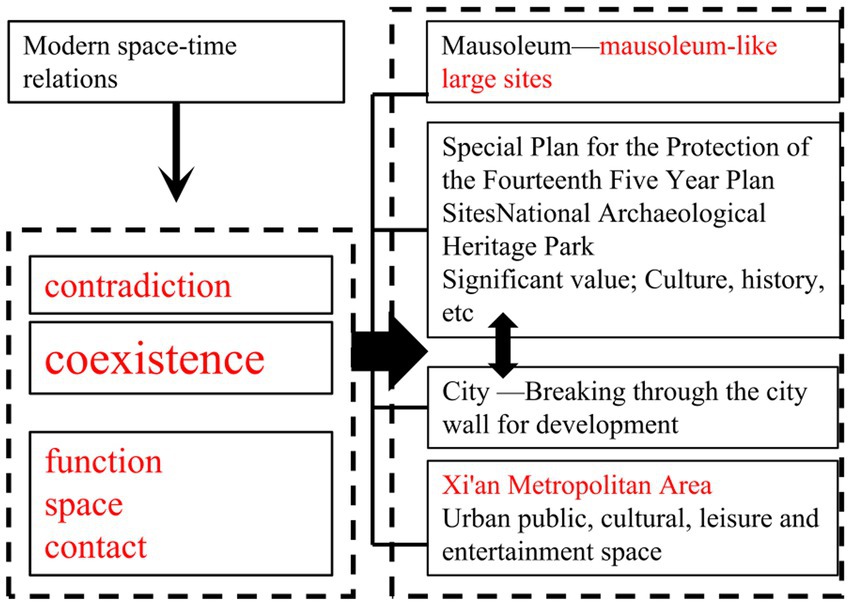
The City breaks through contemporary ideas about the City wall and gradually modernizes urban planning. But it has become a part of a large site, known as a mausoleum-type large site, even though it is not growing. The Spatio-temporal evolution of the two coexists with connections and contradictions (Table 3; Figures 4, 5).
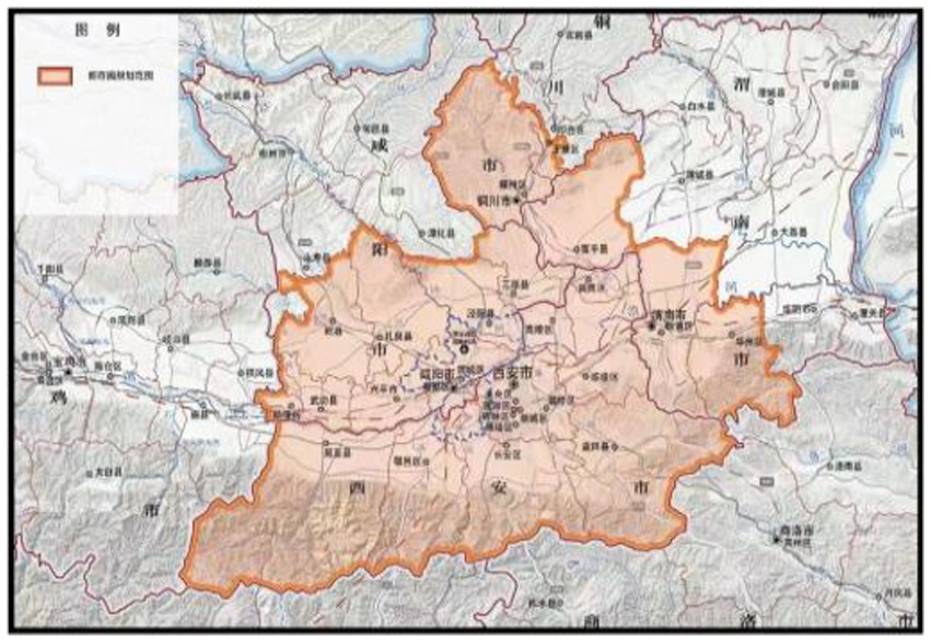
Figure 5. Planning of the Xi’an Metropolitan Area. (Source: Xi’an Metropolitan Area Development Plan).
2.4.3. Urban present: The proposal of the Xi’an metropolitan area
In 2022, the Xi’an Metropolitan Area Development Plan (Figure 5) is the blueprint for Xi’an’s urban development (Qianwen and Shiliang, 2016). Among them, the Xi’an Metropolitan Circle’s narrative of cultural development and inheritance contains the following:
Promote the development of cultural inheritance by conducting comprehensive and systematical archaeology and research on the splendid ruins of Xi’an. Establish an experimental zone for the ecological protection of the Chinese. Strengthen the preservation of Xi’an and Xianyang as national historical and cultural centers. Encourage the construction of historic districts and the optimization of cultural spaces, including Xianyang Qin, Qujiang Tang, Lintong Qin, and Xixian Han cultures. Support Xi’an in building a tourism hub City. Establish an intelligent tourism informatization platform in Xi’an Metropolitan Area. Enhance the national cultural industry demonstration park’s level of development and its role as a driving factor in Qujiang New Area. Stimulate the establishment of demonstration bases for national-level cultural and technology integration, like the Xi’an Cultural and Scientific Technology Entrepreneurship City Industrial Park and the Xi’an National Digital Publishing Base. Accelerate the establishment of national culture export centers like the Xi’an High-tech Zone.
2.4.4. Mausoleum changes: An overview of the conservation and development of the great ruins of Xi’an
1. Principle: Adhere to archaeological support, adhere to protection first.
For the purpose of protecting and utilizing important sites, archaeological research is essential. Pertinent research should examine the preservation and usage of large sites, support the principle of “archaeology first, then transfer,” and promote a compelling relationship between archaeology, conservation, and display.
2. Retrospective: The Historical Progression of the Park Model.
Xi’an protects and promotes the utilization of significant ruins through park development to address the requirements of urban construction and people’s lives while also considering some extensive urban and suburban ruins. Most of the early heritage parks were built before the 21st century, and this stage belongs to the embryonic period of the cultural relics protection concept, including Xingqinggong Park. However, no consideration was given to how the site and its artifacts could be protected (Lin, 2016).
Later, the “heritage park” with the core concept of cultural relics protection was developed, characterized by the integration of the site and its environment. However, the means of site display is single, and the value of cultural relics cannot be fully displayed.
3. New modes: National Archaeological Site Park.1
The National Archaeological Site Park (Xu, 2019) was proposed around 2010 based on conservation and display utilization. Under the debate of conservation and utilization (Petit and Lambin, 2002), archaeological site parks are a novel model for the protection and utilization of sites. Afterward, Xi’an constructed national archaeological sites and parks, including the Mausoleum of Qin Shi Huang on the outskirts of the City and the Daming Palace in the City, protecting the authenticity and integrity of the sites (Banfi et al., 2019).
4. Contemporary: Current situation and problems.
Conflicts during urban development between the protection and utilization of significant sites and the spatial development and construction of cities include: (i) the conflict between urban and rural planning and special planning of national archaeological site parks and (ii) conflicts between urban development and heritage park planning (Lam, 2020). The National Archaeological Site Park’s “one park, one policy” is currently not entirely implemented, and there are few alternatives to make the large site “come alive.” The connotation is evident from how the site is used. The mode is relatively single (Pagliarin, 2018).
5. Prospect: The 14th Five-Year Plan for the Protection and Utilization of Great Heritage Sites and the Integrated Development of Cities in Xi’an Metropolitan Area.
In the “14th Five-Year Plan for the Protection and Utilization of Large Sites,” it is stated that the relationship between the protection and utilization of significant sites and the spatial development, ecology, and culture of the City in the Xi’an Metropolitan Area should be properly handled to adhere to integration and development (Shuai, 2021). In this context, the protection and revitalization of large sites should be strengthened, and the integration of large sites into modern life should be encouraged (Jingyi, 2020) (An overview of the author is shown in Figure 6).
3. Results
3.1. Kernel density analysis of spatiotemporal relationship evolution
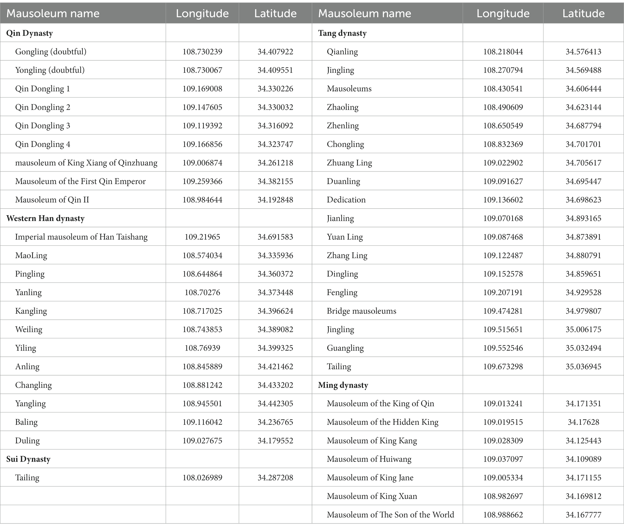
According to the coordinates of 55 mausoleums through the Gaode API system (Table 4) and the results of nuclear density analysis (Linru at al., 2022), the spacetime relationship of the mausoleums are as follows:
1. From Banpo to the Tang Dynasty, according to the nuclear density analysis chart, the density of the mausoleum cores is getting denser and denser, and the eccentricity of the standard deviation ellipse (Figure 7I) of the cumulative distribution of the mausoleum gradually increases, indicating that the spatial range of the distribution of these elements gradually increases and tends to be evenly distributed. During the Qin Dynasty, the center of gravity of the mausoleum was biased toward Xian Yang Yuan in the north of Chang’an. The Han Dynasty began to include Shaolingyuan and Bailuyuan in the south. As a mausoleum in the expansion phase, Tang Yin Mountain’s center of gravity is biased to the north (Figures 7A–F).
2. In the Ming Dynasty, the capital City was not Xi’an, and the cumulative center of gravity was slightly smaller than that of the Tang Dynasty. It depicts the mausoleum’s retraction stage regarding its temporal and spatial relationships during this period (Figure 7G). Since no important mausoleums were added, the Qing dynasty, until modern times in the Republic of China, is identical to the Ming period (Figure 7H; Osman et al., 2016; Alvarez-Palau et al., 2019).
3. Entering the modern era, Xi’an urban development broke through the City wall. From 1985 to 1995, 2005 to 2015, and 2020 to 2022 (Figures 7J–O; Xiaopeng and Haicao, 2021), the establishment of the Xi’an Metropolitan Area, Xi’an’s urban spatial development, and mausoleum-like large sites intersect and overlap in space (Statistics, 2014; Changsong et al., 2021).

Figure 7. Space–time relationship GIS diagram: (A) Banpo Site (about 5,000 B.C.–4,500 B.C.), (B) Western Zhou Dynasty (1,046 B.C.–771 B.C.), (C) Qin Dynasty (Qin Dynasty capital Xianyang 350 B.C.–221 B.C., Qin Dynasty BC221 B.C.–206 B.C.), (D) Western Han Dynasty (202B.C.–8 A.D.), (E) Sui Dynasty (581 A.D.–618 A.D.), (F) Tang Dynasty (618 A.D.–907 A.D.), (G) Ming Dynasty (1,370 A.D.–1,644 A.D.), (H) The Qing Dynasty and the Republic of China (1,644 A.D.–1,949 A.D.), (I) standard deviation ellipse, (J) In 1,985 A.D., (K) In 1,995 A.D., (L) In 2,005 A.D., (M) In 2,015 A.D., (N) In 2,020 A.D., (O) Xi’an Metropolitan Area in 2,022 A.D. (Source: Author draws with software).
3.2. Analysis of the spatial–temporal relationship between urban space and Its mausoleum
3.2.1. Elevation and water system superimposed nuclear density analysis
The Spatio-temporal relationship of nuclear density is accumulated on the elevation and water system. Besides, it can be analyzed that the majority of cities and mausoleums are built in high places and close to the water system (Fanood and Saradj, 2013).
It can be concluded that the capital of Qin was in Xianyang, and the distribution of Qin’s imperial mausoleums in the high terrain was the first phase in the North Banling District, and the Zhiyang mausoleums District was the second phase. The Shi Huang Mausoleum, Han Sen Zhai Mausoleum, and Shenhe YuanLing District are three phases. In the Western Han Dynasty, nine mausoleums were all in Xianyang Yuan, Baling was in Bailuyuan, and Duling was in Shaolingyuan. Tang Yishan is a mausoleum, and the capital of Tang was located in Longshouyuan, with higher terrain. The mausoleum of the King of the Ming Dynasty is located in Shaolingyuan. The mausoleums of the Qin, Han, Sui, and Ming dynasties are all located near water sources, which is the Feng Shui treasure land, and are all atop higher earth mounds. From the Qing Dynasty, the Republic of China, until the present, there are no significant mausoleums.
3.2.2. Distance analysis
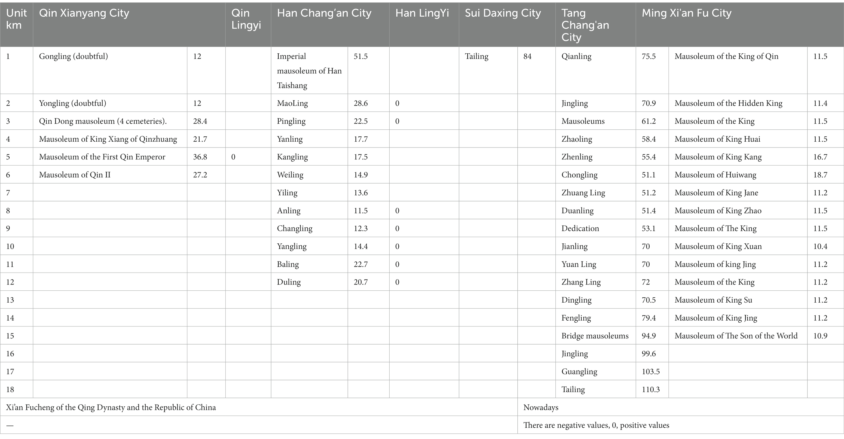
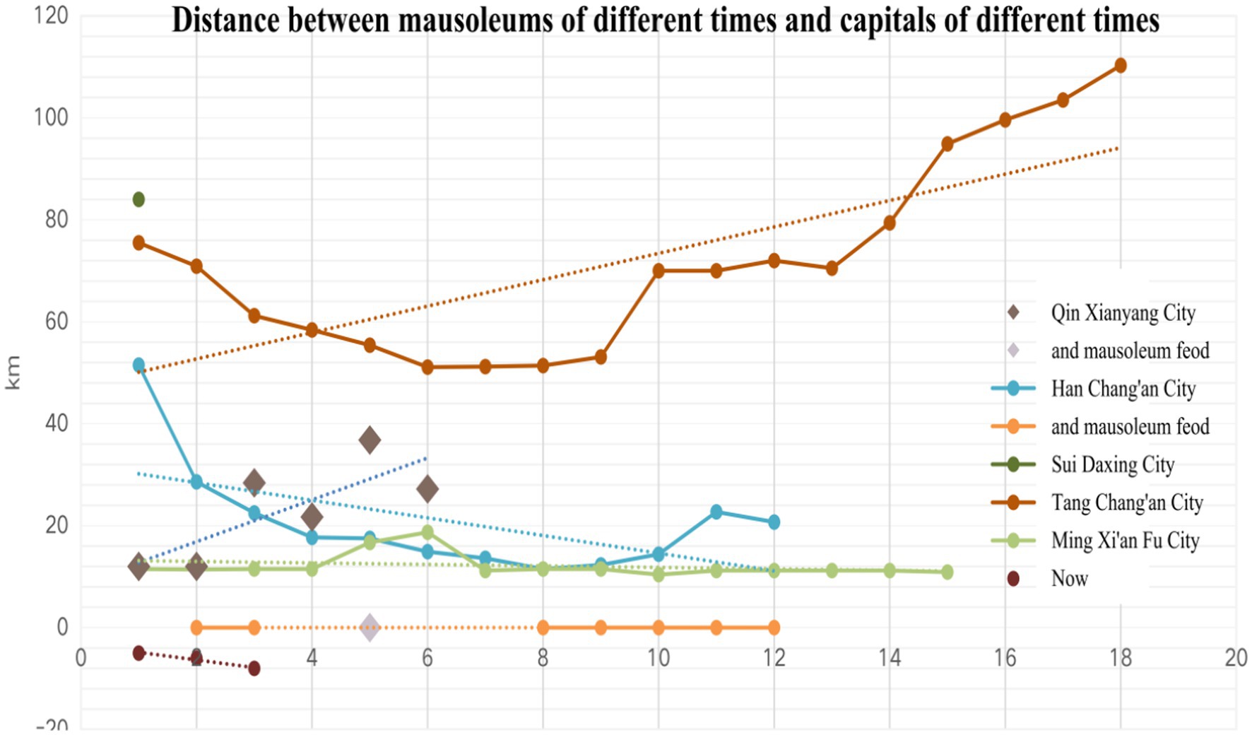
From the Qin and Han dynasties to the Ming Dynasty, in addition to the Sui and Tang dynasties, other mausoleums are about 10–30 km away from the mausoleum; mausoleums of no emperors in the Qing Dynasty and the Republic of China; In modern times, there are negative values, 0, and positive values in the distance between the mausoleum sites and the City (Fei and Ning, 2022).
3.2.3. Correlation analysis of the urban area, mausoleum area, and distance from Pearson
External analysis from the City area, mausoleum area, and space (data source Table 5; Figure 8, urban area, mausoleum area from the weighted average of the data in the above table), can be seen in the following table (Fei, 2018). The correlation between area, volume, and distance is examined using correlation analysis, and the Pearson correlation coefficient is used to represent how strong the correlation relationship is. Specific analysis showed that the correlation value between the area and the mausoleum was 0.970, and the significance of the level of 0.05 indicated a significant positive correlation between the urban area and the mausoleum. The value of the correlation between space and distance was noted as 0.973 and revealed a significance of 0.05 level, thus indicating a significant positive correlation between area and distance (Tables 6A,B,C).
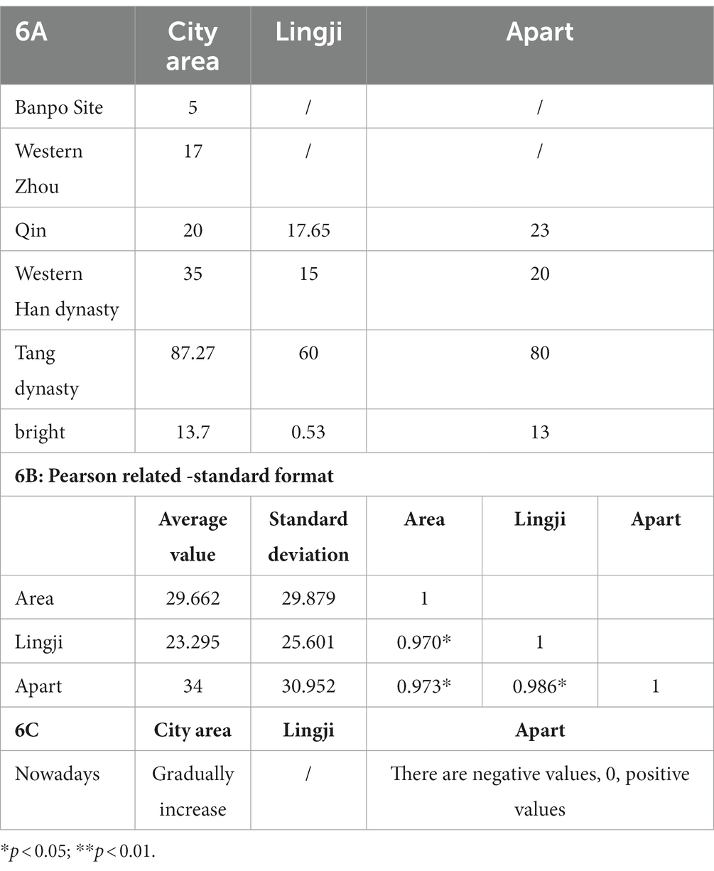
Table 6. Pearson correlation analysis (A) City area, mausoleum, distance data, (B,C) Pearson correlation coefficient table.
Modern relevance: the area of the City gradually expanded, and no new mausoleums were built (Fei and Ning, 2022). The distance between the City of Xi’an and the extensive ruins of the mausoleum, of which the mausoleums of King Xiang of Qinzhuang and Qin II, are negative, indicating that they have been surrounded by urban development. Duling, Baling, etc., are close to zero, and the connection and contradiction with the City are prominent; Other mausoleums are positive and some distance from urban space.
4. Discussion
4.1. The intrinsic relationship between spacetime relations
Prehistoric period: Functional partitions began to appear on the Banpo Site.
Capital Period: The mausoleum of the Fenghao King of the Western Zhou Dynasty was laid out around Fenghao. The Qin and Han Dynasties were the first periods of China’s grand unification, and Xianyang and Chang’an, as the capital cities, were even grander in scale and had the highest status. Besides that, Mausoleum feod was also produced at the same time, increasing the temporal and spatial relationship between the City and the mausoleum. The Sui and Tang dynasties were the heydays of Chinese history, and Chang’an City, with a population of more than 1 million, was also the largest City in the world at the time. As can be seen from the above-given table, the capital City and the mausoleum are positively correlated (Chen et al., 2012).
Post-capital period: The Ming Dynasty Xi’an City is the “post-capital era” in the history of Xi’an’s urban development. Since the Tang Dynasty, the northwest region has not been established from an urban perspective, and Xi’an’s status as the capital has progressively changed to become the center of the northwest region (Ruikun, 2021). The temporal and spatial relationship between the City and the location and layout of the mausoleum has also shrunk and changed. The Ming Period is essentially equivalent to the Qing Dynasty, the Republic of China, until modern times. Until today, the opportunities in various periods include the third line construction, the western development, the Belt and Road, the national central City, the Guanzhong urban agglomeration, and the Xi’an metropolitan area. Xi’an’s urban space has broken through the thinking of the City wall in modern times so that the development of Xi’an and the gradual progress of urban modernization can be realized. The mausoleum became part of the large site, a large site of the mausoleum type. However, with the evolution of time and space and the impact of urbanization, contradictions have gradually become prominent, and urban problems need to be solved urgently (Fei and Ning, 2022).
A crucial stage in constructing the mausoleum space is the determination of Xi’an’s status, which demonstrates the development of the functional area of the ancient capital City (Wu et al., 2005). In other words, the capital City is not only the space inside the City wall but also the spatial order of the power is planned and designed in a particular area. The status and role of the mausoleum are particularly prominent.
4.2. Functional contact
The functional connection between the City and the mausoleum is improving and evolving as time and space’s relationship evolves.
First of all, from the mausoleums and urban functional zoning in Banpo to the defensive and economic functions of the mausoleums in Qin and Han Dynasties. In the Tang Dynasty, mountains were used as mausoleums. Former mausoleums, such as Du mausoleum, were used as places for people to visit. Up to the Ming Dynasty and modern times, the mausoleums were mainly incremental. The mausoleums are currently an integral part of the site, mainly in stock.
How can the contradiction between mausoleum and urban space be resolved? The National Archaeological Heritage Park has recently been activated and incorporated into the Xi’an’s urban development (Iwata and Oguchi, 2009), and the mausoleum site has emerged as a new spatial function of the City for recreation, leisure, greening, etc.
5. Conclusion
The current study summarizes the evolution of spatio-temporal relations from matter to spirit through the analysis of the spatial–temporal relationship between Xi’an City and its mausoleum. This relationship is inextricably linked to the development of Spatio-temporal relations between Xi’an City and its mausoleum.
From ancient to modern times, there has always been a relationship between the Spatio-temporal development of Xi’an City and its mausoleums, and the nuclear density area distance layout of the mausoleums is intimately connected to the status and nature of Xi’an City. Xi’an City and its mausoleum have other classes, functions, and nature in different historical periods. The connection and contradiction between Xi’an City and the spatial development of its mausoleum have been created in modern times (Li et al., 2018).
Currently, mausoleums are part of site protection (Qianwen and Shiliang, 2016). However, because of the large space of the mausoleum, the contradiction between the protection and utilization of mausoleum sites and the development of urban space is revealed. This paper hopes to provide urban planners and site protectors with ideas and data support for the Spatio-temporal development of cities and mausoleums and realize the integration of the protection and renewal of mausoleum sites into the path of urban design and planning. Realize the “combination of City and mausoleum.”
Data availability statement
The datasets presented in this study can be found in online repositories. The names of the repository/repositories and accession number(s) can be found in the article/Supplementary material.
Author contributions
JL the main idea and writing of the article. LZ guidance and communication. JZ, YL, and QH auxiliary writing. SC translation. All authors contributed to the article and approved the submitted version.
Funding
This research was supported by Key Scientific and Technological Innovation Team of Shaanxi Province (grant no. 2020TD-029).
Acknowledgments
We thank TopEdit (www.topeditsci.com) for its linguistic assistance during the preparation of this manuscript. And thank the families who accompany me.
Conflict of interest
The authors declare that the research was conducted in the absence of any commercial or financial relationships that could be construed as a potential conflict of interest.
Publisher’s note
All claims expressed in this article are solely those of the authors and do not necessarily represent those of their affiliated organizations, or those of the publisher, the editors and the reviewers. Any product that may be evaluated in this article, or claim that may be made by its manufacturer, is not guaranteed or endorsed by the publisher.
Supplementary material
The Supplementary material for this article can be found online at: https://www.frontiersin.org/articles/10.3389/fevo.2023.1158563/full#supplementary-material
Footnotes
1. ^The National Archaeological Site Park refers to a specific public space with important archaeological sites and their background environment as the main body, with functions, including scientific research, education and recreation, and with national demonstration significance in the protection and display of archaeological sites. The State Administration of Cultural Heritage is responsible for the assessment and management of the National Archaeological Site Park.
References
Alvarez-Palau, E. J., Martí-Henneberg, J., and Solanas-Jiménez, J. (2019). Urban growth and long-term transformations in Spanish cities since the mid-nineteenth century: a methodology to determine changes in urban density. Sustainability 11:6948. doi: 10.3390/su11246948
Banfi, F., Brumana, R., and Stanga, C. (2019). Extended reality and informative models for the architectural heritage: from scan-to-BIM process to virtual and augmented reality. Virtual Archaeol. Rev. 10, 14–30. doi: 10.4995/Var.2019.11923
Bin, H., Minqing, Z., Yuan, L., and Jian, Z. (2020). Study on the display and utilization of underground relics from the perspective of Integrated Station-City development. Archit. J., 165–170.
Bowei, L. (2017). The lost pearl—the Qin king of the Ming dynasty and his mausoleum in history. New West :90 +83.
Changsong, W., Yu, H., Ya’nan, W., and Yongjie, Z. (2021). The formation and evolution of Xishan cultural landscape in Beijing. Urban Dev. Stud. 28, 66–73. +33.
Chen, L. L., Sun, J. H., and Sun, K. Q. (2012) “The conflict and development between resource, environment and tourism: a case of the ruins of Koguryo as the world cultural heritage site in Ji’an, China”, in: 1st International Conference on Energy and Environmental Protection (ICEEP 2012). (Durnten-Zurich: Trans Tech Publications Ltd), 2452−+. doi: 10.4028/www.scientific.net/AMR.524-527.2452
Daoping, Y. (2022). Research on the spatial layout characteristics and influencing factors of Chongqing’s service industry based on POI data. Master’s degree Southwest University, Chengdu, China. doi: 10.27684/d.cnki.gxndx.2022.001443
De la Luz Hernández-Flores, M., Otazo-Sánchez, E. M., Galeana-Pizana, M., Roldán-Cruz, E. I., Razo-Zárate, R., González-Ramírez, C. A., et al. (2017). Urban driving forces and megacity expansion threats. Study case in the Mexico City periphery. Habitat Int. 64, 109–122. doi: 10.1016/j.habitatint.2017.04.004
Estoque, R. C., and Murayama, Y. (2016). Quantifying landscape pattern and ecosystem service value changes in four rapidly urbanizing hill stations of Southeast Asia. Landsc. Ecol. 31, 1481–1507. doi: 10.1007/s10980-016-0341-6
Fanood, M. R., and Saradj, F. M. (2013). Learning from the past and planning for the future: conditions and proposals for STONE conservation of the mausoleum of CYRUS the great in the world heritage site of PASARGADAE. Int. J. Archit. Heritage 7, 434–460. doi: 10.1080/15583058.2011.643527
Fei, W., and Ning, G. (2022). Exploring the spatio-temporal characteristics and driving factors of urban expansion in Xi’an during 1930–2014. Int. J. Urban Sci. 27, 39–64. doi: 10.1080/12265934.2022.2085152
Hang, L. (2016). Mausoleum Feods are very important in the Western Han dynasty. 2016-08-12. Social Sciences in China.
Iwata, O., and Oguchi, T. (2009). Factors affecting late twentieth century land use patterns in Kamakura City, Japan. Geogr. Res. 47, 175–191. doi: 10.1111/j.1745-5871.2008.00559.x
Jingyi, Q. (2020). Research on the launch in the form of composition and its application in logo design. Master’s degree Nanjing Normal University, Nanjing, China.. doi: 10.27245/d.cnki.gnjsu.2020.001759
Kane, K., Tuccillo, J., York, A. M., Gentile, L., and Ouyang, Y. (2014). A spatio-temporal view of historical growth in Phoenix, Arizona, USA. Landsc. Urban Plan. 121, 70–80. doi: 10.1016/j.landurbplan.2013.08.011
Lam, H. K. (2020). Embodying Japanese heritage: consumer experience and social contact at a historical Themed Park. J. Intercult. Stud. 41, 262–279. doi: 10.1080/07256868.2020.1751598
Li, G. D., Sun, S. A., and Fang, C. L. (2018). The varying driving forces of urban expansion in China: insights from a spatial-temporal analysis. Landsc. Urban Plan. 174, 63–77. doi: 10.1016/j.landurbplan.2018.03.004
Liancheng, L. (1988). A study on the two capital cities of Fenghao in the Western Zhou dynasty. J. Chin. Hist. Geogr. 3, 115–152. doi: CNKI:SUN:ZGLD.0.1988-03-007
Liang, Y. (2016). Western Zhou jade fish in the museum. Natl. Mus. Shaanxi Hist. 249-250+396-399+251-253. doi: CNKI:SUN:SXBW.0.2016-00-039
Lin, L. (2016). Research on conservation and construction to the surrounding spatial setting of Xi’an great heritage sites. PhD diss Xi’an University of Architecture and Technology, Xi’an, China.
Linru, L., Dong, Z., and Chunhua, S. (2022). Research on pattern evolution of near-water traditional rural SETTLEMENTS in the YILUO River basin. Ind. Constr. 52, 104–110. doi: 10.13204/j.gyjzG21092613
Ming, L. (2020). Study on Changan capital circle in Western Han dynasty—From the perspective of spatial layout and hierarchical functions. Master’s degree Northeast Normal University, Changchun, China. doi: 10.27011/d.cnki.gdbsu.2020.001361
Osman, T., Divigalpitiya, P., and Arima, T. (2016). Driving factors of urban sprawl in Giza governorate of greater Cairo metropolitan region using AHP method. Land Use Policy 58, 21–31. doi: 10.1016/j.landusepol.2016.07.013
Pagliarin, S. (2018). Linking processes and patterns: spatial planning, governance and urban sprawl in the Barcelona and Milan metropolitan regions. Urban Stud. 55, 3650–3668. doi: 10.1177/0042098017743668
Petit, C., and Lambin, E. (2002). Long-term land-cover changes in the Belgian Ardennes (1775–1929): model-based reconstruction vs. historical maps. Glob. Chang. Biol. 8, 616–630. doi: 10.1046/j.1365-2486.2002.00500.x
Qianwen, Z., and Shiliang, S. (2016). Determinants of urban expansion and their relative importance: a comparative analysis of 30 major metropolitans in China. Habitat Int. 58, 89–107. doi: 10.1016/j.habitatint.2016.10.003
Ruikun, W. (2021). From Chang’an to Xi’an: transitions in pattern and form of Chang’an City Wall since the tang dynasty. Heritage Archit. 02, 89–97. doi: 10.19673/j.cnki.ha.2021.02.010
Shiwu, X., Wenliang, C., Xiaomeng, C., and Xiaoxiang, L. (2021). Study on spatial evolution and development of the settlement space in the ruins area by the perspective of human-land relationship: an Empirical analysis of Settlements in Chang’an City ruins area of Han dynasty. Modern Urban Res., 45–52.
Shuai, X. (2021). The state Administration of Cultural Heritage printed and distributed the “fourteenth five year plan” for the protection and utilization of large sites. China Cultural Relics News. 2021-11-19. doi: 10.28145/n.cnki.ncwwb.2021.001694
Sichao, L., and Hui, S. (2020). Analysis on spatial distribution pattern of traditional villages in Shaanxi and its correlation. Urbanism Archit. 17, 100–103. doi: 10.19892/j.cnki.csjz.2020.31.24
Statistics, X.a.M.B.o. (2014). “Xi’an statistical yearbook 2014 “. China Statistics Press Beijing People’s Republic of China).
Wenliang, C., Jianxiong, J., and Menglin, S. (2021). A study on the governance mode of large heritage sites from a multiscale perspective: an empirical analysis based on the Chang’an city site of the Han dynasty. City Plan. Rev. 45, 48–56+105.
Wu, H., Jiang, J., Zhou, J., Zhang, H., Zhang, L., and Ai, L. (2005). Dynamics of urban expansion in Xi’an City using Landsat TM/ETM+ data. Acta Geograph. Sin. 60, 143–150.
Wu, T. H., u, B., and Wang, X. R. (2016). How ancient Chinese constellations are applied in the city planning? An example on the planning principles employed in Xianyang, the capital city of Qin Dynasty. Science Bulletin, 61, 1634–1636. doi: 10.1007/s11434-016-1188-6
Xi, Y., and Ling-fu, L. (2012). The West Han Dynasty’s establishment of the town of Changling and its effects. J. Shaanxi Norm Univ. (Philos. Social Sci. Ed.) 41, 86–91.
Xiaopeng, F., and Haicao, Q. (2021). Analysis on the characteristics of the tempo-spatial evolution of Xi’an metropolitan area. Urban Stud. 28:6.
Xu, J. (2019). Research on the development of Shaanxi cultural Relics Park. Master’s Theses Northwest University, Xi’an, China. doi: 10.27405/d.cnki.gxbdu.2019.000272
Keywords: urban spatial structure, evolution of Spatio-temporal relations, mausoleums and mausoleum-like large sites, GIS, Xi’an metropolitan area
Citation: Liu J, Zhang L, Zhao J, Liang Y, Han Q and Chirwa S (2023) Exploration of the spatial relationship between Xi’an City and its mausoleums from the perspective of time evolution. Front. Ecol. Evol. 11:1158563. doi: 10.3389/fevo.2023.1158563
Edited by:
Nallapaneni Manoj Kumar, City University of Hong Kong, Hong Kong SAR, ChinaReviewed by:
Shruti Agrawal, Malaviya National Institute of Technology, Jaipur, IndiaMeena Kumari Kolli, Indian Institute of Technology Bombay, India
Copyright © 2023 Liu, Zhang, Zhao, Liang, Han and Chirwa. This is an open-access article distributed under the terms of the Creative Commons Attribution License (CC BY). The use, distribution or reproduction in other forums is permitted, provided the original author(s) and the copyright owner(s) are credited and that the original publication in this journal is cited, in accordance with accepted academic practice. No use, distribution or reproduction is permitted which does not comply with these terms.
*Correspondence: Lei Zhang, emwud2NAY2hkLmVkdS5jbg==
 Jiaqi Liu
 Lei Zhang1*
