 Maria Marcela Godoy
 Sebastián Martinuzzi
 Pablo Masera
 Guillermo E. Defossé
- 1National Scientific and Technical Research Council (CONICET) – CIEFAP, Andean Patagonian Forest Research and Extension Center, Forest Engineering University of Patagonia, Esquel, Argentina
- 2SILVIS Lab, Department of Forest and Wildlife Ecology, University of Wisconsin–Madison, Madison, WI, United States
- 3CIEFAP, Andean Patagonian Forest Research and Extension Center, Forest Engineering University of Patagonia, Esquel, Argentina
- 4National Scientific and Technical Research Council (CONICET) – CIEMEP Patagonian Mountain and Steppe Esquel Research Center, Forest Engineering University of Patagonia, Esquel, Argentina
Wildland Urban Interface (WUI) areas are rapidly expanding worldwide. In many regions of the world, this expansion could be explained by the increasing possibilities of telecommuting and developing home-office work, while at the same time living in, or surrounded by wilderness areas of magnificent beauty. However, growth and development of these WUIs are still not well dimensioned and regulated, especially in fire prone ecosystems. Over the last two decades, an increasingly number of megafires occurred in these WUI areas in different regions of the world. Recently, big megafires occurred in WUIs located around towns in the western Andean-Patagonian region of Argentina. In this study, we analyzed the evolution of the WUI and its relationship with wildfires around cities and towns located in the northwestern part of Chubut province of Argentina. The studied region covers 324,823 ha and includes the cities of Esquel and Trevelin, and other small villages. Our objectives were to (i) map the current WUI, (ii) quantify changes occurred in the WUI in the last 40 years around the main cities of the region, and (iii) analyze the relationships among WUIs, vegetation types, and wildfire occurrence. We mapped the distribution of WUI using spatially explicit information on housing density derived from censuses and high-resolution imagery from 1981/1982 and 2021, and land cover data. The current WUI covered 8% of the study area, however it has 97% of the houses. Between 1981 and 2021, the WUI area increased by 80%, especially in the southern part of our study region. Finally, information on wildfires distribution revealed that 65% of the ignition points of the recent fires in the region occurred within the WUI. Most of the vegetation burned were herbs, sub-shrubs and woodlands. WUI expansion in our study area appears to be constrained by terrain features (slopes and accessibility), but not by vegetation characteristics. Our study suggests that continuing, unplanned housing expansion in wilderness areas without appropriate vegetation management will likely increases wildfire risk and human environmental conflicts further. Effective land use planning and wildfire management are crucial for sustainable housing expansion in western Patagonia.
Introduction
Fire as a disturbance exists on earth since the beginning of the times (Komarek, 1962; Wright and Bailey, 1982; Pyne, 2020). Fire has greatly contributed to shape the structure and functioning of most terrestrial ecosystems, helped boosted human evolution and development (Attwell et al., 2015; Defossé, 2021), and provided also many ecosystem services (Pausas and Keeley, 2019). However, over the past two decades, wildfires around the world have increasingly affected human values, assets, and ecosystem services (Moritz and Knowles, 2016). Besides, climate change and continued development on fire-prone landscapes will increase impacts of wildfires, like high suppression costs and loss of lives and properties (Bowman et al., 2017). Not only climatic conditions but also human activities influence fire regimes through their effects on ignition sources and fuel characteristics in many parts of the world (Flannigan and Wotton, 1991; Agee, 1993; Veblen et al., 1999; Defossé et al., 2015). Particularly in Northern Patagonia, humans have influenced changes in fire regimes at multidecadal times scales since the middle 19th century (Veblen et al., 1999).
The tendency of the urbanization nearby or within forest ecosystems is a worldwide phenomenon that increases every year. Not only in the United States (Martinuzzi et al., 2015), but also in Europe (Moreno et al., 2014), Canada (Johnston and Flannigan, 2018; Parisien et al., 2020), and in Chile (Sarricolea et al., 2020) and Argentina in South America (Argañaraz et al., 2017; Godoy et al., 2019), some people living in large urban centers have chosen to migrate near the wilderness to enjoy living close to nature (Veblen et al., 2008; Defossé et al., 2015).
Broadly defined Wildland Urban Interfaces (WUI) are areas where houses and human activities intermingle or abut with natural, wildland vegetation (Radeloff et al., 2005, 2018). One of the biggest problems that the global community faces today is the wildfire occurrence in the WUIs. This is due not only to the increasing presence of people living in high hazard areas, but at the same time to the likelihood that wildfires will threaten structures and people (Bar Massada et al., 2009). During the last 40 years, WUIs have been expanding in many regions around the globe, mainly due to land use changes like in Europe (Xanthopoulos et al., 2012; Urrutia-Jalabert et al., 2018; Ganteaume et al., 2021), and increasing urbanization in western North America, Australia, and parts of Chile and Argentina (Hammer et al., 2007; Theobald and Romme, 2007; de Torres Curth et al., 2012; Úbeda and Sarricolea, 2016; Argañaraz et al., 2017; Radeloff et al., 2017, 2018; Godoy et al., 2019; Sarricolea et al., 2020). Independent from their origin, one common factor shared by most WUIs around the world is that they grew and expanded in wildland areas surrounded by fire prone vegetation, particularly in WUIs settled in Mediterranean type of climates. These climates are characterized by wet winters and long, hot, dry summers, as in Patagonia, Argentina. In rich amenity regions like in western Patagonia, Argentina, the WUI is where most fire risks, ignition points, and wildfires occur (Godoy et al., 2019). A close relationship of fires in Nothofagus antarctica (G. Forst.) Oerst. woodlands with the proximity to urban populations, in the same region was shown by Mermoz et al. (2005). Moreover in that region, in the city of Bariloche, which is surrounded by Nahuel Huapi National Park, fires appear as an emergent of social conflicts related to poverty (de Torres Curth et al., 2012). In the same region, there are pine plantations, most of them located nearby towns and roads (Bava et al., 2016), which may be of concern because they are fire prone and produce sharp changes in the vegetation structure and fuel loads (Paritsis et al., 2018). Despite that, well managed plantations are less prone to fire (Godoy et al., 2013) in comparison to no-managed ones.
A similar situation as described in Patagonia, Argentina, can be seen in the central part of Chile, where three million people live in WUI areas (McWethy et al., 2018; Bowman et al., 2019). There, the largest wildfires are becoming more frequent and concentrated (Sarricolea et al., 2020), and are human caused (CONAF, 2018; Pozo et al., 2022). In south-central Chile, McWethy et al. (2018) reported that more than 85,700 ha burned annually between 2010 and 2017, and plantation forests, mixed native-exotic forests and native sclerophyll forests are the vegetation types most burned by wildfires.
Wildfire ignitions occur in WUIs around towns in southern central Chile (Miranda et al., 2020; Pozo et al., 2022) and in western-central Patagonia in Argentina, where the distribution and density of most of ignitions show a concentration in the WUIs, and diminishes toward their peripheries and less populated areas. In fact, a study in central western Patagonia showed that in a big area (337,000 ha) composed of similar vegetation types as the reported in this study, 77% of the fire ignitions occurred in the WUIs areas around towns (Godoy et al., 2019). Similar results were presented by Mundo et al. (2013), in northern Patagonia. With respect to climate in Chile and Argentina, fire history studies have linked forest fire activity in the southern range of the Andes to warm and dry conditions associated with El Niño Southern Oscillation ENSO (Holz and Veblen, 2012; Mundo et al., 2013; Holz et al., 2017). It is also expected that wildfire activity will increase in most WUIs during the 21st century (Mansoor et al., 2022), and in the western province of Chubut in Patagonia the tendency is to have maximum and minimum increased between 1 and 2°C in the next 50 years (SMN, 2019). Catastrophic fires have already occurred in Andean WUI in northwestern Chubut in Patagonia during the hot and dry 2010–2011 and 2011–2012 fire seasons (Defossé et al., 2015), but even more catastrophic fires have occurred in the 2020–2021 fire season, causing three fatalities and hundreds of burned houses. Besides, population in the WUI are growing at rates from two to three time faster in Andean Patagonia than in the rest of Patagonia or in the whole Argentina (INDEC, 2021), mainly due to urban residents trying to find new lifestyle in a rich amenity region (Farías and Defossé, 2009; Godoy et al., 2019).
Maps are important tools for understanding development patterns and potential ecological stressors including wildfire (Radeloff et al., 2005; Theobald and Romme, 2007; Calkin et al., 2019). For these reasons, WUI maps are of fundamental interest for wildfire management in those areas. Wildland Urban Interfaces create environments in which wildfires can move readily from forests and grasslands into neighborhoods (Martinuzzi et al., 2015). The scientific information generated should be the basis to design WUIs development plans aimed at reducing wildfire risk and create fire safe communities living in these WUIs.
The objective of this study was to examine and analyze the WUI and WUI growth of a particular region of northwestern Chubut, Argentina, which surrounds the towns of Cholila, Esquel and Trevelin, and the villages Aldea Escolar, Lago Rosario, and Los Cipreses (Figure 1). All these towns and villages are located within a fire prone region of Andean Patagonia in Argentina, which has witnessed a strong population growth and many wildfires in recent decades. Our specific objectives were to: (i) map the current WUI, (ii) quantify WUI growth in the last 40 years, and (iii) analyze the relationships among WUI and fire ignition points, burned areas and type of vegetation.
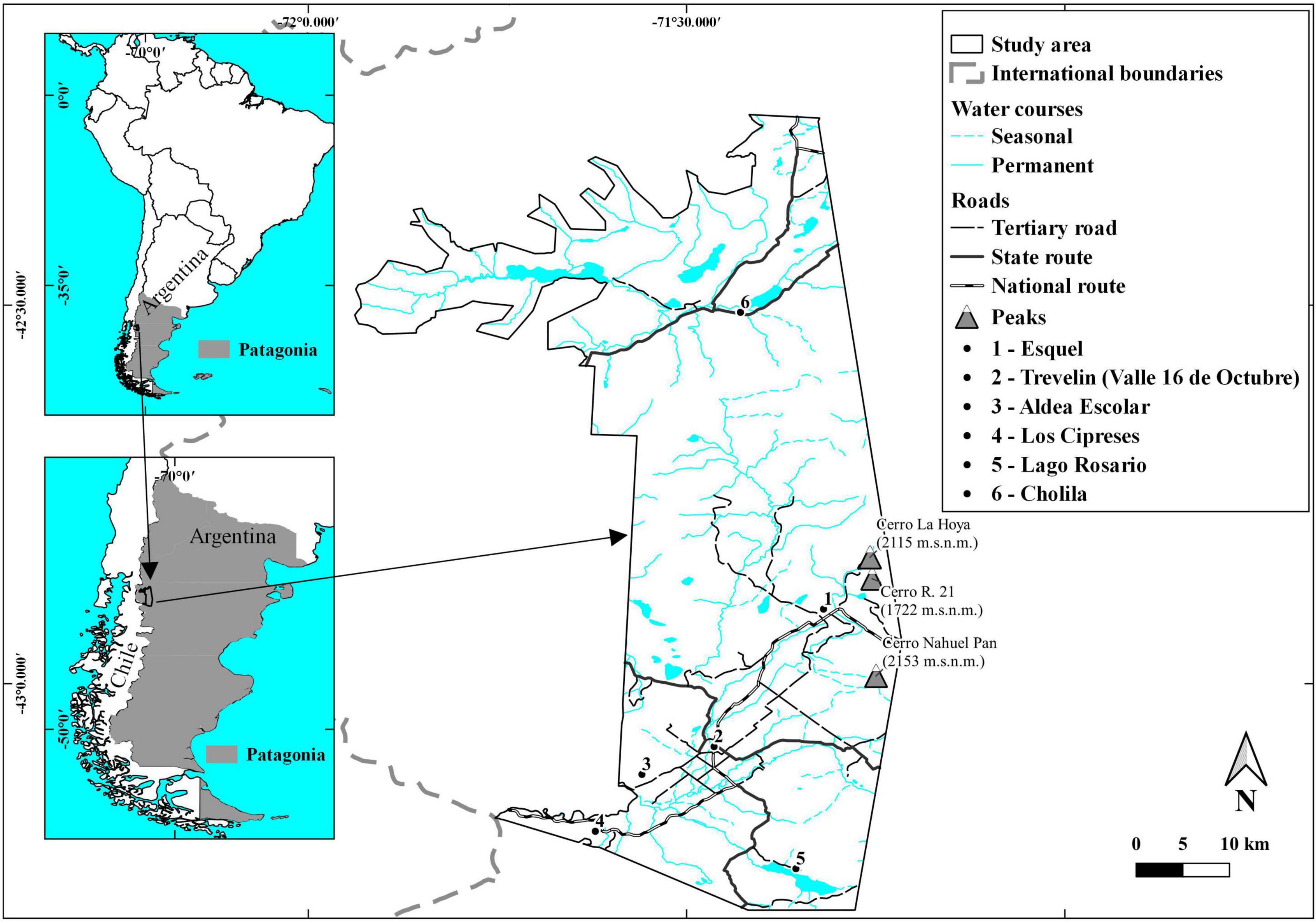
Figure 1. Study area. It is located in south-western Argentina, in the Patagonian region.
Materials and Methods
Study Area
Our study area covered 324,823 ha around the city of Esquel (563 masl), the most populated city in western Chubut, near the Andes in Central Patagonia, Argentina. The study area limits to the North to the Provincial Reserve “Nacientes del Río Tigre”, to the West to Los Alerces National Park, to the South to native forests of N. antarctica “Ñire” and to the East to the Patagonian Steppe. There are mountains like La Hoya (2,050 m of elevation), and valleys like 16 de Octubre Valley, that has 385 masl (Figure 1).
The climate of the study area is Mediterranean, with the majority of the annual precipitation occurring during the winter months (June to September in the Southern Hemisphere), followed by a drought period that goes from early spring (October) to late summer (April in the southern Hemisphere). Annual rainfall is lowest toward the East in the steppe (400–600 mm) and moderate at higher elevations (600–1,500 mm) toward the West (Defossé et al., 2015). Vegetation types also change rapidly along the elevation gradient from east to west, in one of the steepest precipitation gradients in the world (Veblen and Lorenz, 1988). Most of the area is located in the Occidental District of the Patagonian Steppe (Soriano, 1956), where grasses like Pappostipa and Festuca spp., Poa huecu, Poa ligularis, Bromus macranthus, and shrubs such as Fabiana patagonica, Fabiana imbricata, Adesmia campestris, Mulinum spinosum, and Senecio filaginoides grow. Westward, our study area limits with the Subantarctic Andean Forest, where it forms an ecotone with the Patagonian Steppe. Here, mixed forests are dominated by the trees N. antarctica (G. Forst) Oesrt. and Austrocedrus chilensis (D. Don) Florin et Boutleje “ciprés”) as well as shrubs and the grasses mentioned before. A map showing the main vegetation types can be found in Figure 2.
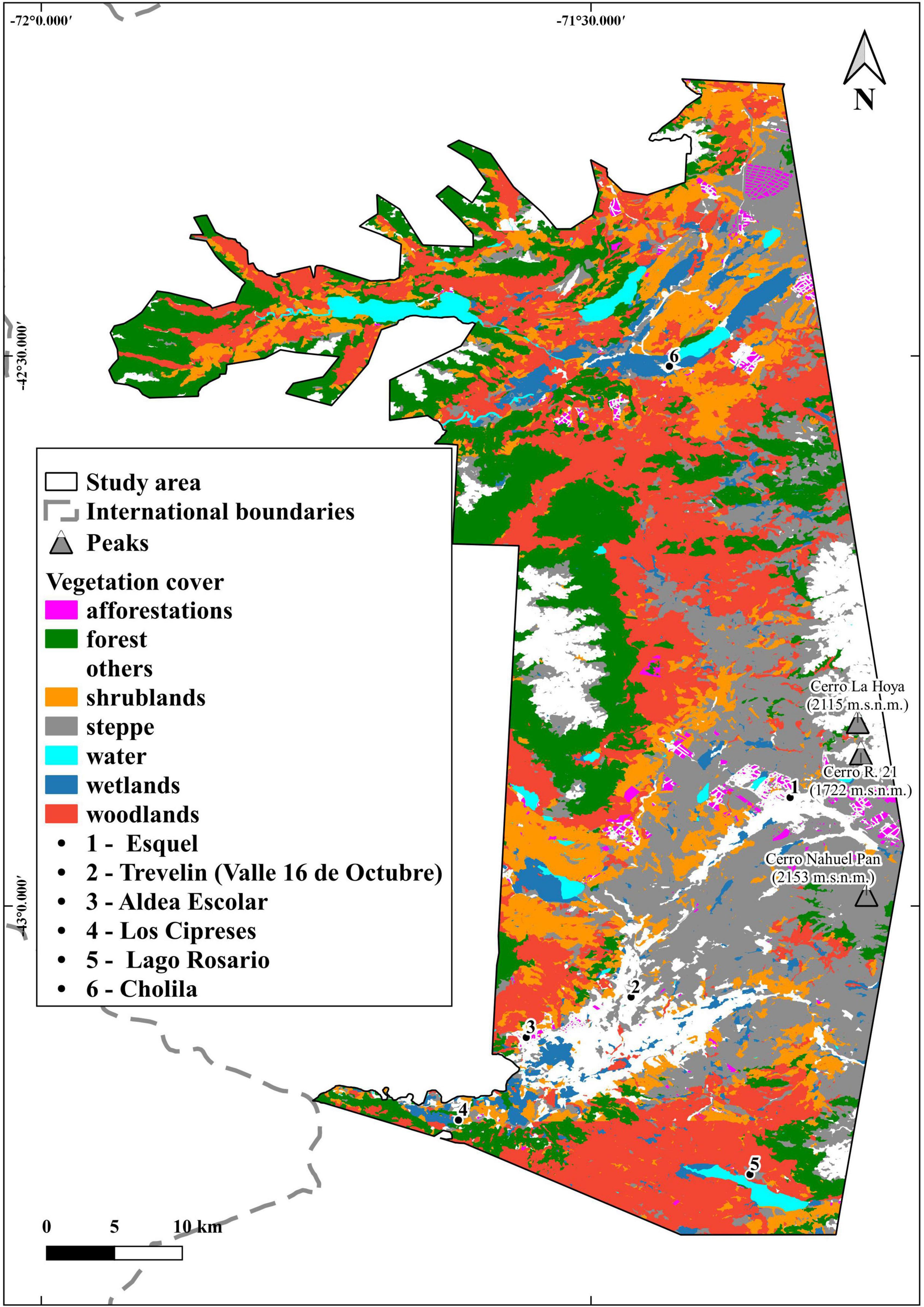
Figure 2. Main vegetation types of the study area derived from CIEFAP and MAyDS (2016) main vegetation types of the study area. Forests are Austrocedrus chilensis–Nothofagus forests. Afforestations are Ponderosa pine forests. Woodlands are open areas dominated by N. Antarctica trees and surrounded by scattered shrubs and bushes. Steppe are areas dominated by grasses. Others is the area occupied by the villages, towns, agricultural and pasture lands, rocks, and high peaks without vegetation. Shrublands is the area dominated by low-dense shrub vegetation.
In the past and up to the 1990s of the last century, economic activities were mainly based in natural resources as timber and extensive livestock and sheep production. Nowadays, government administration is the main economic, followed by tourism, and extensive use of natural resources such as extensive livestock and crop production, including berries and some organic vegetables. Pine afforestations were planted between 1983 and 2006, covering 1,100 ha, and abut the city of Esquel, toward the northwest and the southeast of that town. There are also pine afforestations near the town of Cholila.
Tourism and fly fishing are increasingly important economic activities that attract people from different origins mainly due to the natural scenery of the region, many fishing rivers and which includes natural parks and ecological reserves. La Hoya, a mountain with an elevation of 2,050 m and 16 km distance of Esquel, lodges a small ski resort with good quality snow.
Data and Approach
Objective I: Map the Current Wildland Urban Interface
For WUI, We used the definition of the Federal Register (USDA and USDI, 2001), that distinguishes between intermix and interface WUI. Intermix WUI is defined as areas that have at least 6.17 houses km2 intermingled with wildland vegetation, whereas interface WUI are developed areas near wildland vegetation. Based on this definition, Radeloff et al. (2005) set a threshold of 50% of vegetation cover for a given census block for intermix WUI. Interface WUI, however, are those areas with 6.17 housing units km2 that contain 50% of wildland vegetation, but are within 2.4 km of heavily vegetated areas (75% of wildland vegetation) and larger than 5 km2.
We map the WUI with the point-based approach method (Bar-Massada et al., 2013), using two spatial datasets: (i) building locations, and (ii) wildland vegetation cover. We digitized building locations from current (ca. 2021) high spatial resolution satellite imagery (15 m resolution on average), as it is available in Google Earth (2021). For the towns of Esquel and Trevelin, we considered the number of houses within census blocks counted in the last pre-census in 2020 (INDEC, 2021) as the number of buildings in each census block and we assigned them randomly following the proposed technique by Bar-Massada et al. (2013); Argañaraz et al. (2017), and Godoy et al. (2019). We suggest that this is an acceptable shortcut because since the house density within any moving windows covering these blocks will always be ≥6.17/km2, irrespective of the exact location of the housing units. For the villages of Cholila, Lago Rosario, Los Cipreses, and other rural settlements as Aldea Escolar and the rest of all the rural housing, we counted them individually in the Google Earth 2021.
We extracted the wildland vegetation cover from a land cover map derived from 10-m pixel SPOT 5, and 30-m LANDSAT TM, ETM+ and OLI imagery (CIEFAP and MAyDS, 2016). We combined that land cover with the data of the National Inventory of Afforestations. We reclassified the vegetation map into wildland and non-wildland vegetation following Bar-Massada et al. (2013); Martinuzzi et al. (2015), and Godoy et al. (2019), where wildland vegetation included forests, woodlands, grasslands, and wetlands, and non-wildland vegetation included horticultural lands, water bodies, rocks, urban areas, and infrastructure (see vegetation map in Supplementary Material).
We mapped the WUI using a moving window of 500 m, following Bar-Massada et al. (2013); Argañaraz et al. (2017), and Godoy et al. (2019). Moving windows where house density was high enough were tested to see if wildland vegetation reached 50% in the moving window (in which case the central pixel was mapped as intermix WUI), or if it was close to a large areas of wildland fuels (in which case those areas not already mapped as intermix WUI, were mapped as interface WUI). Areas not mapped as WUI (interface or intermix) were categorized as non-WUI. To select the size of the moving window, we mapped the WUI with a range of window sizes (100, 200, and 1,000 m) to see how much our results changed with changes in window size (see Supplementary Table 1). For each WUI maps, we calculated the area of the WUI, and the number of buildings in the WUI. We chose the moving window of 500 m radius because it had the largest WUI area with an intermediate number of houses, which is desirable for a most conservative fire risk management strategy.
Objective 2: Map the Wildland Urban Interface in 1981/1982 and Quantifying Changes in Wildland Urban Interface Area
To quantify changes in the WUI from the early 1980s to 2021, we analyzed topographic maps from the National Geographic Institute of Argentina (IGN) to map houses, vegetation, and WUI in 1981/1982, following the procedure stated in a previous study for mapping WUI changes in El Bolson and its surroundings (Godoy et al., 2019). In the 1981/1982 topographic maps, houses were not mapped individually, and groups of houses, instead, were indicated by a symbol. To create the map of houses in 1981/1982, we started with the 2021 digitized building locations, and removed houses in areas where the land use in the 1981/1982 maps indicated that there were no houses (e.g., forest and wetlands). In areas where the 1981/1982 maps showed houses, we assumed that all the houses that we mapped in 2021 were there at the earlier day already. This represented a conservative approach, because areas with houses in the 1981/1982 topographic maps could have shown an increase in the number of houses by 2021. To assess the accuracy of our method, we compared our estimates of total homes in 1981/1982 to the number of houses reported in the official Census of 1980 (INDEC, 2021).
As our data source for mapping wildland vegetation in the early 1980s, we used again the 2021 land cover map. We suggest that this is justified because, except for the expansion of urban areas, changes in land-use have been small, according to our observations at the 1986 forests maps of Chubut province (Instituto Forestal Nacional [IFONA], 1986) and historic images of Google Earth from 1985. Using the same wildland vegetation cover data therefore represents a conservative estimate of wildland vegetation in the 1980s. We calculated WUI changes both in terms of area (ha and % change) and buildings (quantity and % of change).
Objective 3: Analyze the Relationships Among Wildland Urban Interface and Fire Ignition Points, Burned Areas, and Type of Vegetation
In regards to our third objective, we quantified the incidence of wildfires from 1981 to 2021 that occurred in our study area. The data from burned areas came from CIEFAP and Subsecretaría de Bosques e Incendios from Chubut Province (unpublished data). Burned area polygons were mapped by taking GPS points on the ground, as well as digitizing satellite images. All wildfire sizes were mapped and counted per year.
We calculated the number and area of wildfire polygons that overlapped the WUI.
Vegetation data was derived from the land cover maps from CIEFAP, the same one that is mentioned in the objective 1.
Ignition Points
Data from ignition points, whether or not they have progressed to wildfires, were obtained from two sources. First ignition data source is from the Ministerio de Ambiente y Desarrollo Sustentable (Ciámpoli, personal communication, 2021), which has continuous data from 2017 to nowadays, although not published. The second source of ignition data is from the Fire Information for Resource Management System (FIRMS, 2021), which has data from 2000 to nowadays. We calculated the number of ignition points that overlapped the WUI.
For a better understanding of how we proceed with this study, see Figure 3.
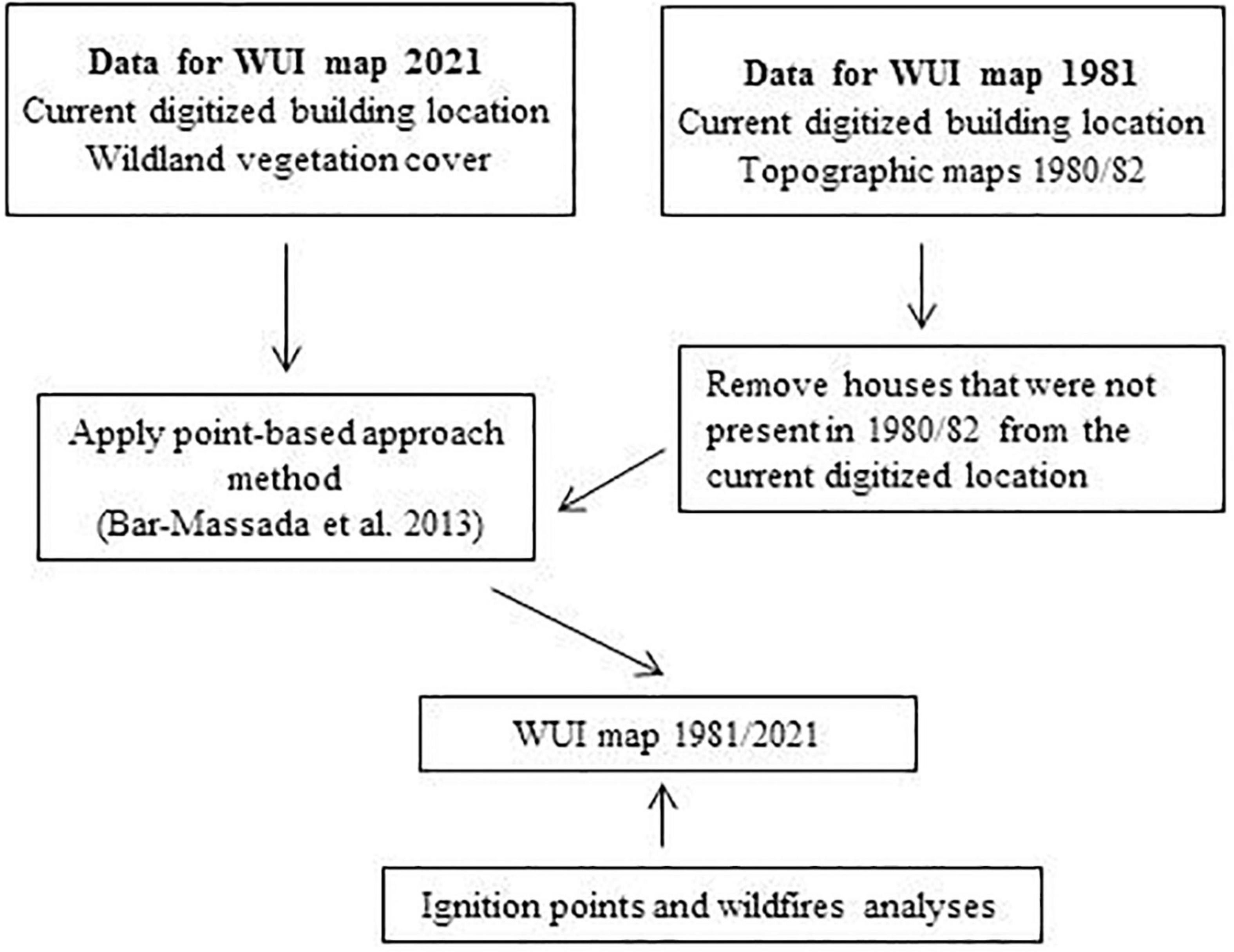
Figure 3. A chart showing the workflow of the study.
Results
Current Wildland Urban Interface
We mapped 23,049 buildings in our study area in 2021, according to the pre-census (INDEC, 2021) and to the housing that can be seen through Google Earth. The WUI covered 25,176 ha, which was equal to only 7.8% of the entire study area, yet the WUI contained 97% of all buildings (Table 1). Within the WUI, the area of intermix WUI was more than two times larger than that of the interface WUI (i.e., 17,515 vs. 7,661 ha). However, the interface area nearly doubled the number of houses comparing with the intermix area (14,824 and 7,596 for interface and intermix WUI respectively, Table 1). WUI areas were concentrated along valleys and included all urban centers (i.e., Cholila, Esquel, Trevelin, and rural settlements such as Los Cipreses and Lago Rosario), as well as surrounding areas with low-density housing such as Aldea Escolar (Figure 4). All the interface areas were surrounded by intermix areas, but not all the intermix areas had interface areas limiting them, and that occurred in places with low housing density.
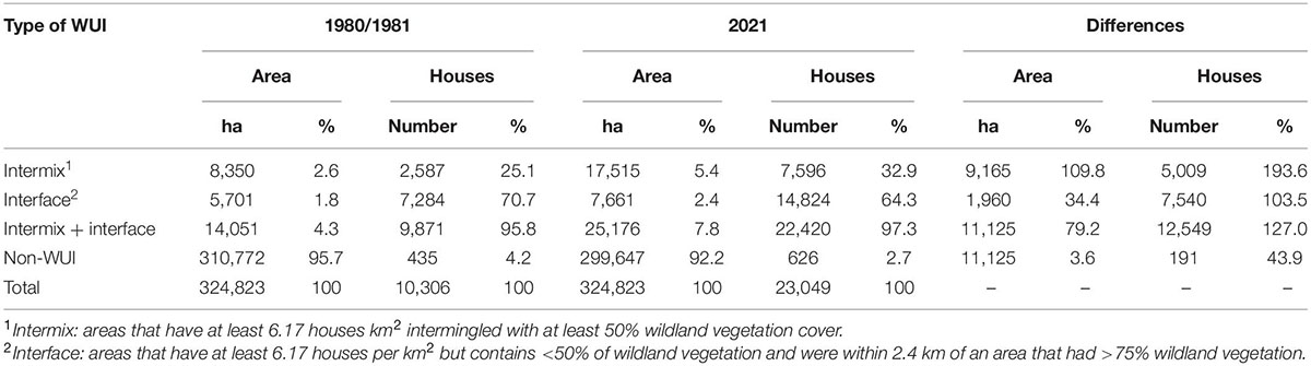
Table 1. Area and number of houses in the study area for the periods 1980–1981 and 2021 and its differences.
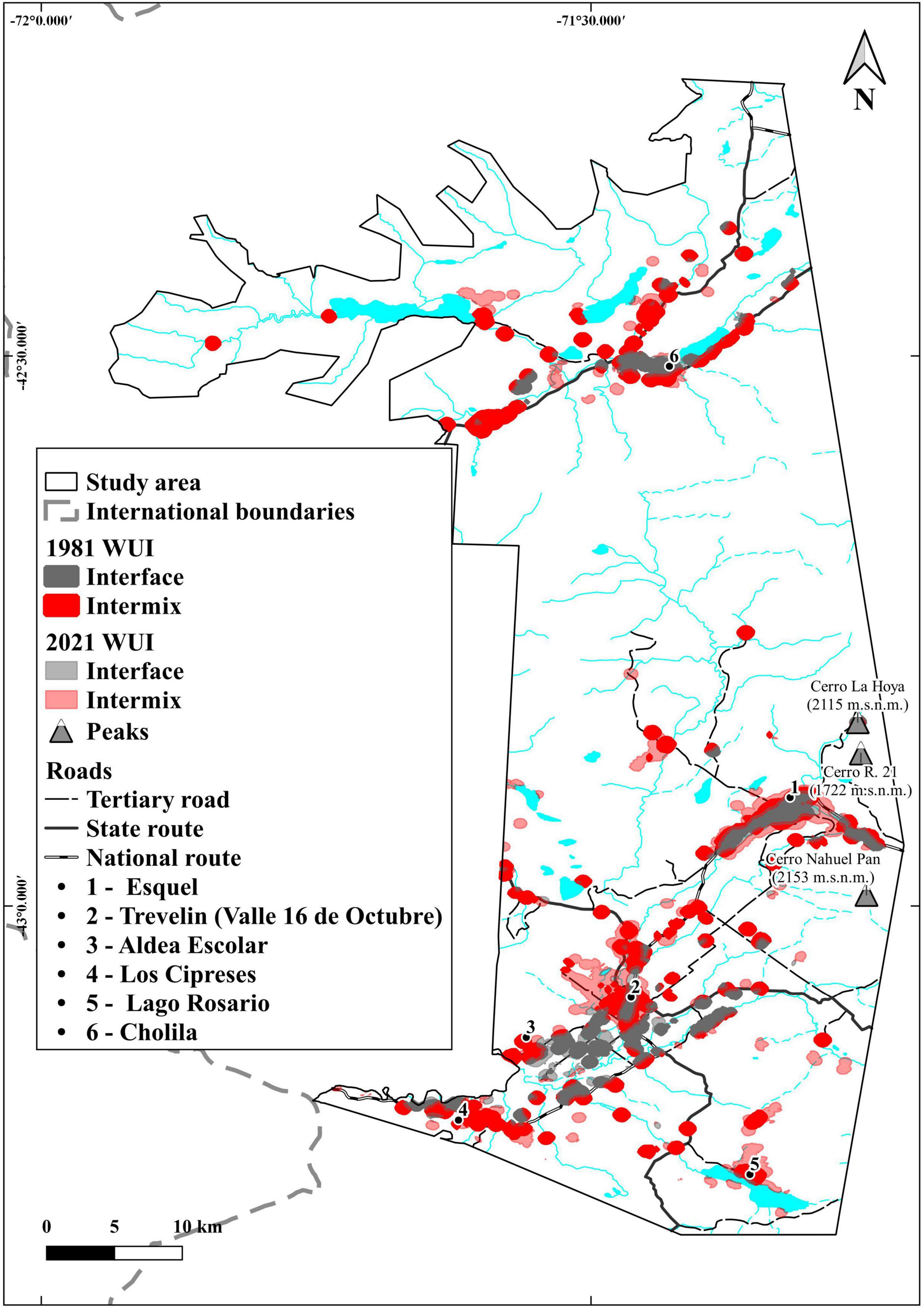
Figure 4. Wildland Urban Interface in the study area. WUI in 1981: the interface zone is in yellow, the intermix zone is red. WUI in 2021: the interface zone is in gray and the intermix zone is in pale red.
Changes in the Wildland Urban Interface Between 1981/1982 and 2021
The WUI area in our study area expanded by 80%, from 14,051 to 25,176 ha between 1982 and 2021 (Table 1). However, most of this expansion occurred in the intermix WUI, from 8,350 to 17,515 ha.
The WUI change analysis also revealed an increase in the number of buildings by 127%, rising from 9,871 to 22,420 buildings during the same period in the all the WUI (Table 1). The biggest increase is in the intermix WUI, where the number of houses is 4 times there were in 1981/1982, while the number of houses in the interface WUI is the double. Besides, in the non-WUI area there are 191 more buildings in 2021 than in 1981.
The WUI has expanded specially to the south of our study area in the proximity of the towns and rural settlements (Figure 4), as well along the main and secondary roads. Only in the surroundings of Trevelin, there is a difference of ca. 3,500 ha of new WUI between 1981 and 2021. In contrast, Esquel has had 1,600 ha more of WUI expansion (see Figure 5 for details in the town of Esquel and its surroundings). Cholila, a town located in the north part of the study area that has 1,970 ha more of WUI actually than in 1981.
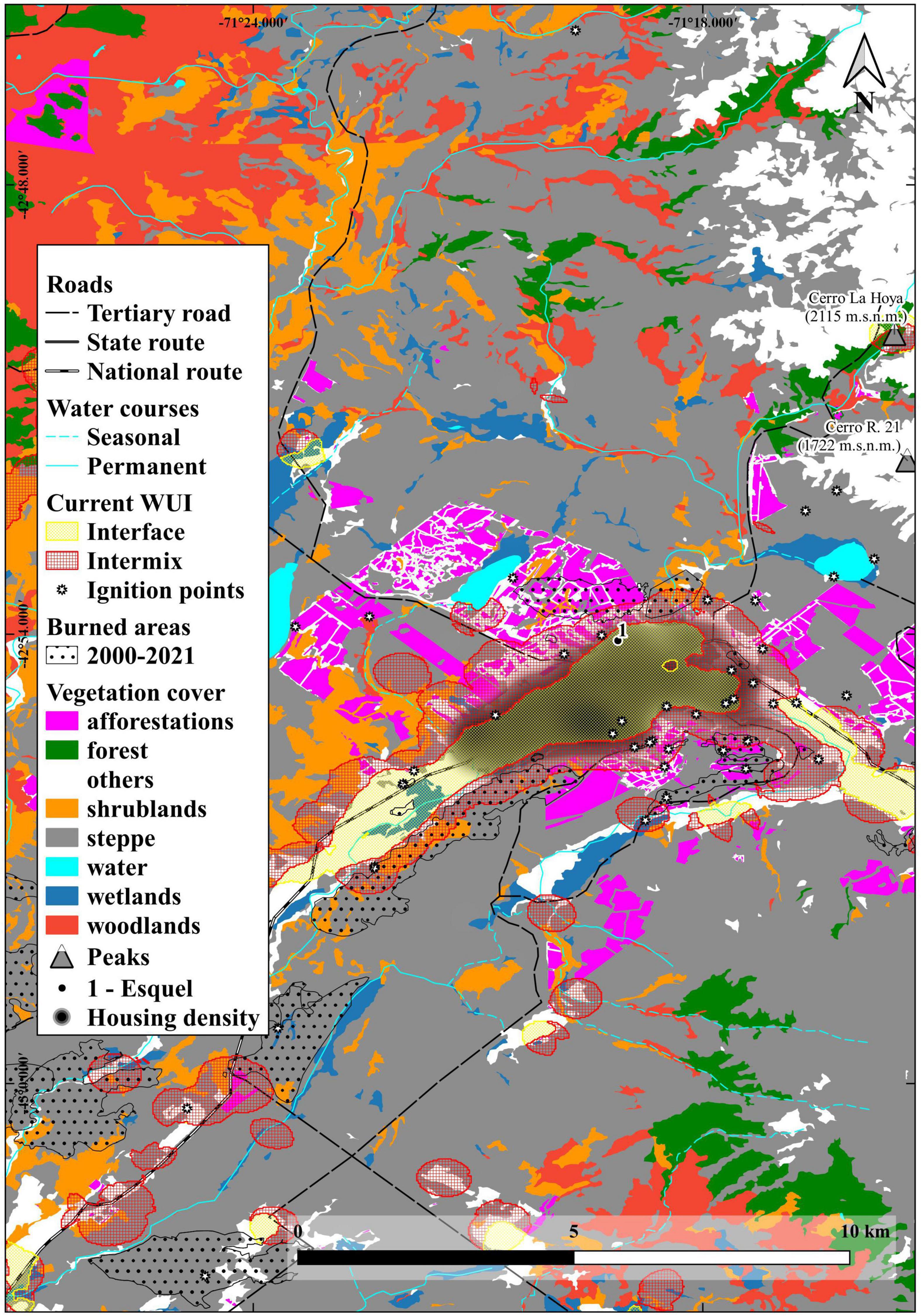
Figure 5. Detail of the town of Esquel and its surroundings. The yellow lines delimits the interface zone red lines delimits the intermix zone. The dotted points indicates wildfires and the white points are the ignition points. Note that afforestations are very near of the town and most of the vegetation type is steppe.
Wildfires in the Study Area
The total area burned between 1981 and 2021 was 47,500 ha, which represents 14.6% of the study area (Figure 6). Of that, 1,168 ha occurred in the current WUI intermix and 129 ha in the current WUI interface. We can also see in Figure 6 that most of the wildfires have occurred in the south of our study area, in the same part where the WUI has grown the most.
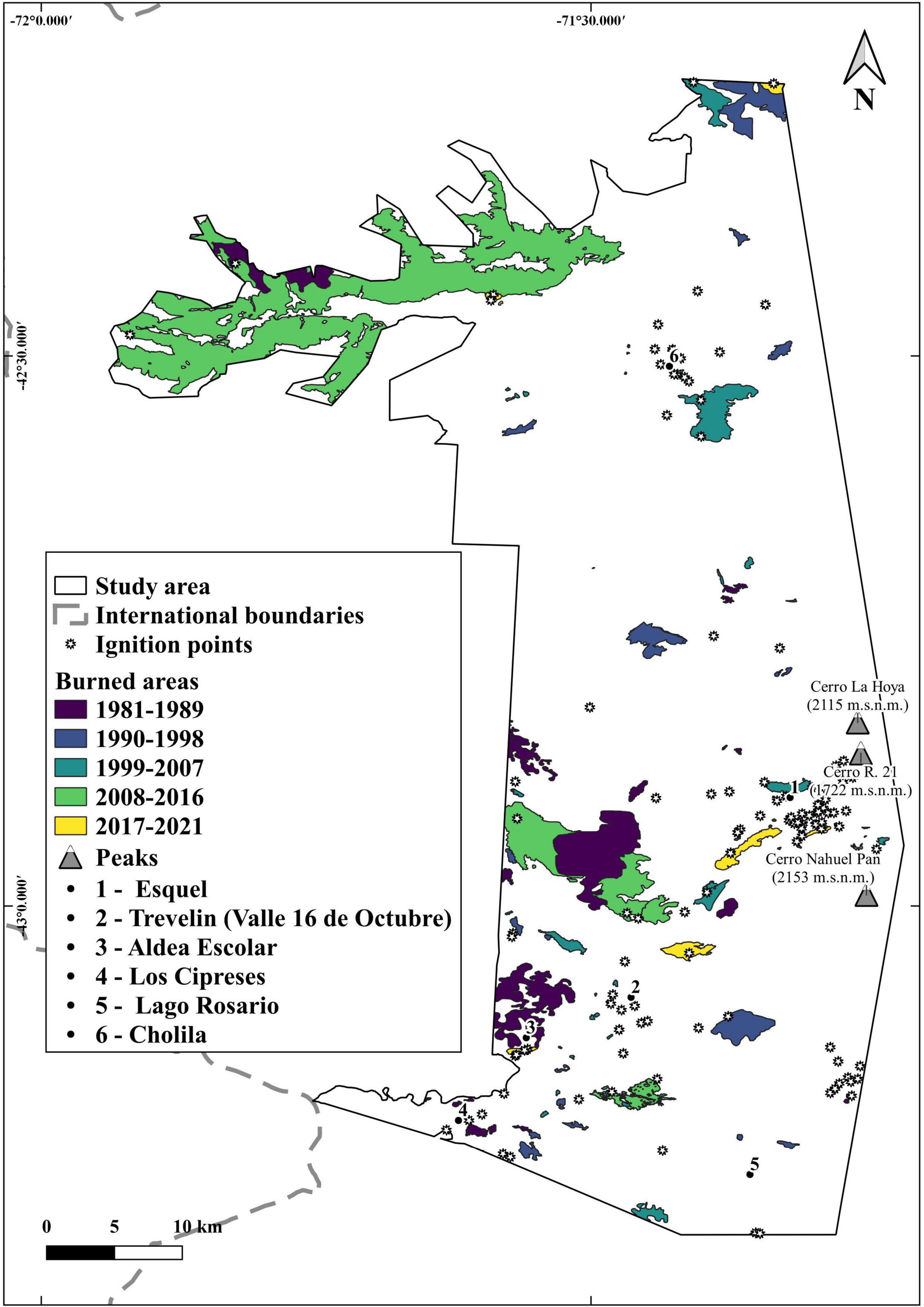
Figure 6. Wildfires in the study area since 1982 and ignition points since 2000, both until 2021. Wildfires are grouped every 8 years, but the last group comprises 3 years.
Since 1981 there were 132 wildfires and we observed that only the 1.5% of those wildfires burned the 60% of the total area burned. The 80% of the fires burned areas up to 100 ha, and 14% of the fires burned areas from 101 and 500 ha. The year 2015 had a few number of fires, although it was when the biggest wildfire occurred and burned 41,000 ha in total and 22,467 ha were in our study area north of Cholila. There were numerous fires in 1982, 1997, 2000, and 2005 but the largest fires in those years did not burned more than 3,347 ha and in a non-WUI area (Figure 7). Furthermore, all the wildfires in the last 10 years bordered the WUI and burned there 599 ha.
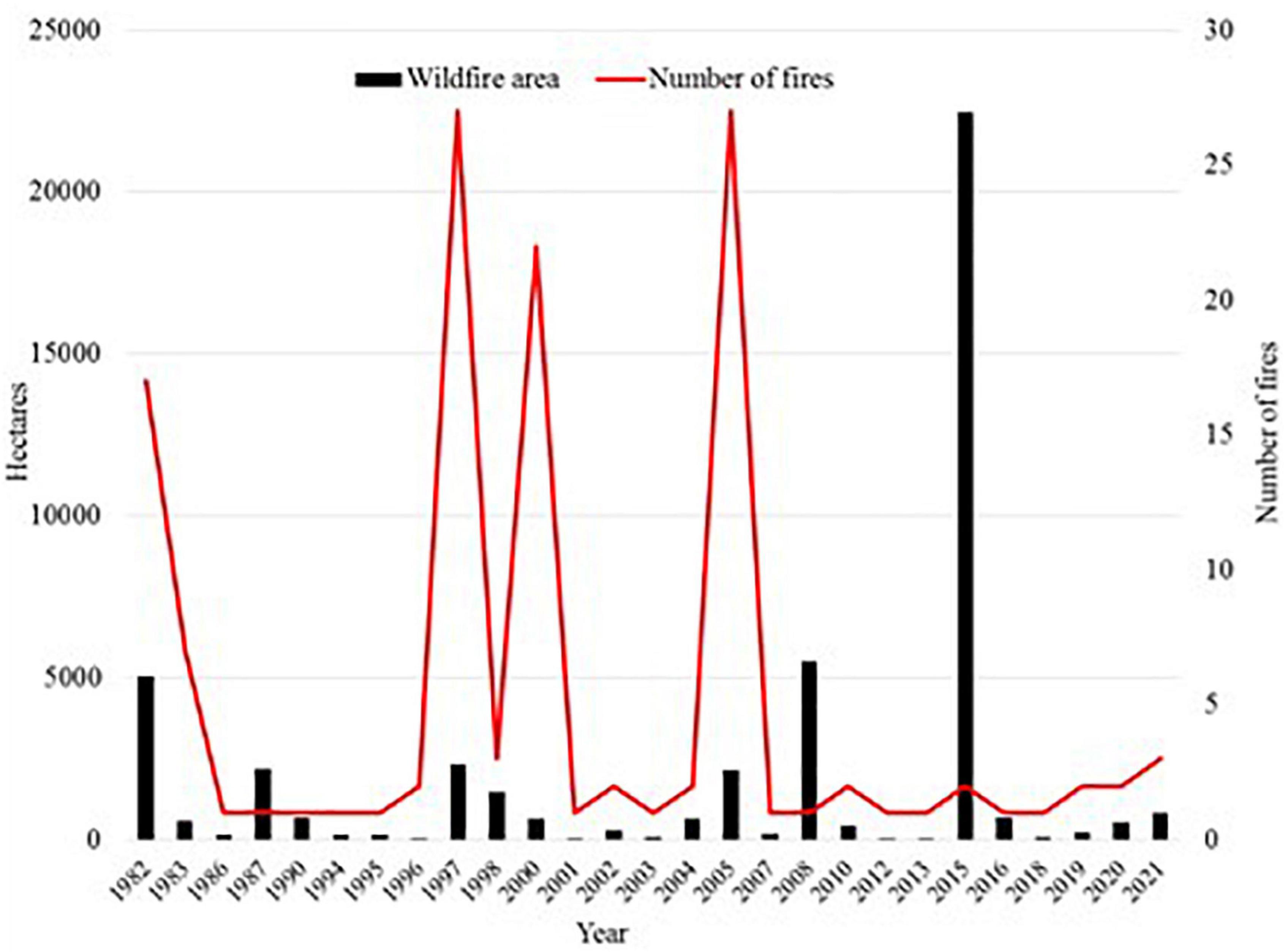
Figure 7. Number and area of wildfires in the study area. In 2015 a few ignitions burned more than 20,000 ha.
Ignition Points
We recorded 114 points of ignition of fire, whether they have begun a wildfire or not in the last 21 years. We found that 65% of the ignition points were located in the WUI. In addition, 80% of them are in the south part of the area, the same situation as observed with the burned areas.
Vegetation Types
Of the different vegetation types that cover the area, 80%, were N. antarctica woodlands, grass and small shrubs steppe, native forests and shrublands in similar proportions each (23, 23, 19 and 15%, respectively, Table 2). Vegetation types in the intermix WUI area was steppe composed of grasses, herbs and small bushes, shrublands and N. antarctica woodlands (24, 18, and 18% respectively, see Tables 2, 3 in the Supplementary Material for a more detailed information). Afforestations of exotic conifers species, mostly ponderosa pine occupy only 5% of the vegetation types in the intermix. In the interface WUI we found several exotic species (not determined) due to landscape gardening.
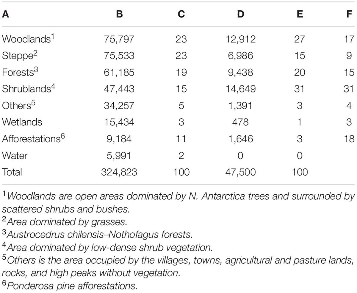
Table 2. (A) Type of vegetation, (B) area occupied by each type, (C) its proportion relative to the area occupied in the study area, (D) burned area per vegetation type, (E) its proportion from the total area burned, and (F) proportion of burned area relative to area occupied by the vegetation type, all of them in the period studied and in the studied area.
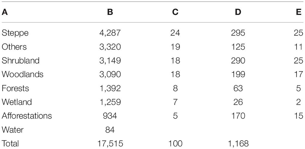
Table 3. (A) Type of vegetation in the intermix, (B) its area, (C) its proportion relative to the total intermix area, (D) area burned in the intermix, and (E) proportion of area burned relative to the total area burned in the intermix WUI.
The five vegetation types that burned most in our study area were shrublands, then woodlands, then native Austrocedrus-Nothofagus dombeyi forests, steppe, and afforestations, and in that order. However, in the intermix WUI the vegetation type that most burned was the steppe, then shrublands, then woodlands and afterward afforestations (25, 25, 17, and 15%, respectively).
Nothofagus antarctica woodlands was the most burned vegetation type in terms of area in the non-WUI zone. From the total area of each type of vegetation, a relatively small proportion was burned up to now (Table 3).
Discussion
We mapped the WUI and its growth in the last 40 years in a fire-prone and growing area in western Patagonia. We found that the WUI represented 7.8% of the total study area, yet it contained 97.3% of all the houses that were present by 2021, and both WUI area and the number of houses grew rapidly since 1981–1982. The proportion of homes found in the WUI, was the same proportion as in central western Patagonia, around El Bolsón, Lago Puelo, Epuyén, and El Hoyo (Godoy et al., 2019), meaning that mostly all the people in a vast region of western Patagonia live in the WUI. The intermix area has grown more than the interface, as mentioned in a previous study (Godoy et al., 2019), showing similar percentages and trends, as we expected for adjacent places with similar environmental characteristics and natural amenities. Given that both types of WUI-interface and intermix- are in fire prone areas, and that most of the people live there, the WUI assessed should be considered to be carefully managed in strategic places at least. This management should be agreed with forest managers of the provincial government and very specific for each vegetation type.
Current Wildland Urban Interface
The WUI in our study area was established around developing towns and villages, as well along their interconnecting roads. Our study area is now an important growing tourism destination because of its richness in natural amenities (Beccaceci, 1998; Consoli, 2019), which is one of the reasons for the increase in the number of people living in this WUI, as occurs in other WUI communities in Patagonia and of the world (Otero et al., 2006; Abrams et al., 2012). This kind of location is very similar as the WUI we analyzed around El Bolsón (Godoy et al., 2019) and other WUI areas in Chile (Pozo et al., 2022), Europe, Canada, and New Zealand (Lampin-Maillet et al., 2011; Modugno et al., 2016; Johnston and Flannigan, 2018; Langer et al., 2018).
The recommendations about reducing all combustible materials within circa 30 m around the houses should be applied as a first and most important prevention plan, like Fire Wise USA (2022) and Fire Smart Canada (2022) practices in United States and Canada. Management practices of the surrounding areas further more than 30 m of the houses should be carefully designed and applied for each vegetation type, at least in some strategic places, so as to change vegetation structure that could change fire behavior, should a wildfire occur. Management forest plans in woodlands and native forests near the towns and villages should be promoted for conservation and timber production, as these type of management implies the reduction of fuel loads. The creation of recreational sites must also be considered. There is no knowledge neither experience about prescribed burning in native forests, woodlands, and shrublands in Patagonia. Therefore, Landesmann et al. (2021) studied fire vegetation feedbacks and plant community type conversions that can guide a prescribed burning plan research for each type of vegetation and situation. Besides, more research is needed to complement fuel models done already in a few vegetation types in the ecotone forest-steppe in Chubut by Bianchi et al. (2012) and fire spread models done for a similar region in Patagonia by Morales et al. (2015) should be considered.
Wildland Urban Interface Growth 1982–2021
The 2021 WUI area was 9,267 ha larger than the WUI in 1981–1982, and 110% of the new WUI was intermix WUI. Our growth analysis focused on new houses in areas with wildland vegetation in 1981–1982, so we expected that the intermix WUI should grow in area, and it did at a rate that was more than 4 times higher the interface WUI growth. We found that this proportion was 8 times higher in our previous study located around El Bolsón, at the north of the current study area (Godoy et al., 2019). We also observed that this growth was higher around the town of Trevelin, possibly for two main reasons: first because the surroundings of Trevelin have smoother slopes in comparison to Esquel and is easier and safer to build houses, and second due to the lower prices of the land in Trevelin, in comparison of those in Esquel.
Fundamentally, there are two processes that can create new WUIs. The building of new homes in or near existing wildland vegetation, or the expansion of the wildland vegetation (Radeloff et al., 2018). The number of houses in our study area increased by 127% and consequently the WUI area expanded by 80%. We assume that the only changes in the vegetation were caused by wildfires and by 9,184 ha of planted new conifer afforestations between 1980 and 2012 (Datos Argentina, 2022). It is reasonable to conclude then, that the WUI growth is mainly the result of new houses and not because an increase of the vegetation. The same happens in most regions in the United States, where housing development in wild vegetation areas is the principal cause of WUI expansion (Kramer et al., 2021). However, intermix WUI had higher housing growth rates (194%), in relation to non-WUI (127%) and interface WUI areas (103%), but in absolute numbers, interface WUI has grown more. The same trend was found in the United States interface growth rates were higher than the intermix and non-WUI areas, considering 20 years of time lapse (Radeloff et al., 2018).
Vegetation Types and Incidence of Wildfires in the Study Area
Woodlands, steppe, native forests, and shrublands were the most frequent vegetation types in our study area. Although afforestations occupy only 4% of the intermix area, their management should be considered to be mandatory in these places because they are all located very near the towns and roads. Traditional management toward low density stands and quality timber production with the removal of slashes will have also the effect of having less fuel load.
Furthermore, we considered vegetation types only in the intermix WUI, and not in the interface, because we assume that there is ornamental vegetation in between the houses that differs from the wildland vegetation by its heterogeneity. Despite this, sometime there are plants in groups that provide a horizontal fuel continuity between the houses, and fire could spread along them from the wildland to the houses or vice versa, in the same way as described by Ganteaume et al. (2021). Modern urban codes that control these types of plant groups should be considered in a short time scale.
The area burned that was covered with forests in our study area in 40 years was relatively considerable – 9,500 ha –, which represented 20% of the total area burned and 14% of the area of forests in our study area. This is quite different what happens in southern Chile, where exotic afforestations are the vegetation type the most burned, then shrublands, and then native forests (de la Barrera et al., 2018), while savannas and different types of forests are the most burned in central Chile (Sarricolea et al., 2020).
We have also observed that pine afforestations only burned 3% of the total area burned, and that was 8% of the total afforestation area. This seems to be opposed to the situation in Portugal and Chile where eucalyptus and pine afforestations are considered to create highly flammable landscapes increasing the risk of extreme fires (de la Barrera et al., 2018; Ganteaume et al., 2021), although in Chile there is also intentional fires because of land ownership conflicts with forestry companies (Úbeda and Sarricolea, 2016).
Incidence of Wildfires in the Wildland Urban Interface
The small area of 1,297 ha burned in the WUI, in the last 40 years, and only ca. 600 ha of them in the last 10 years, could be explained because the current WUI is recently installed, and because there is still a small amount of people who lives there. If humans are responsible for the majority of the ignitions (Rodríguez, 2000; Marini, 2012; MAGyP, 2013; Mundo et al., 2013), and we should expect a more drought conditions in the fire season, more ignitions and wildfires will occur, near or in the WUI. In Patagonia, as well as in other parts of the world, like the Pacific Northwest in United States, increased temperatures are projected to lengthen fire and growing seasons, and the consequences would be increase evaporative demand, decrease soil and fuel moisture, increase likelihood of large fires, and increase area burned by wildfire (Morgan et al., 2003; Villalba et al., 2003; Veblen et al., 2008; Paritsis et al., 2013; Westerling, 2016; Pozo et al., 2022). Decreased summer precipitation is also projected to increase area burned (Holden et al., 2018). Congruently, we should expect a similar situation, and we should be specially aware in the WUI.
From the total ignition points, 65% of them occurred in the WUI. This is comparable with ignitions recorded in south-central Chile, where most of them were located near the largest cities (Pozo et al., 2022). We assume that the number of ignition points is underestimated, as we could only access to available data in the web site (FIRMS, 2021) as well to the one from the Ministerio de Ambiente. However, this makes sense with the fact that there has been a relative small area burned in our study area and in the WUI as well. According to INDEC (2021), the WUI in Futaleufú department (where our study area is located) has more than doubled the number of people in the last 40 years. Besides, the provincial forestry administration has lack of observations and incomplete record keeping of points of ignition and their origin (lightning or anthropogenic). This information could be also be improved assessing fire severity specially in forests using the methodology of Franco et al. (2020) to further design management strategies in those type of vegetation.
There has been no great wildfires in the WUI because fire ignitions have been rapidly turned off. In 2020 a wildfire approached the city of Esquel boundaries and firefighters could control the fire. Although until not long ago there had been no loss of houses, in 2021 a wildfire of extreme behavior burned 511 houses in El Hoyo, that is not in our study area but 64 km north from Cholila. This indicates that the danger is latent and a tragedy could unfold if the vegetation and meteorological conditions are met. Therefore the need to have preventive plans to reduce biomass among others. Management to in native forests near the WUI to produce timber should at the same time reduce biomass and risk of wildfires.
Land use planning must take into account wildfires which are likely to continue to increase in frequency and extent due to climate warming and increased ignitions resulting from having more people on the landscape (Veblen et al., 2008, 2011). Code regulations for houses in the WUI should be updated considering home hardening to fire. People living in the WUI should be better fire-risk informed, and have emergency evacuation plans and enough roads to do so. The topographic constraints should be quantified around each town or village, and taken into account in the land use planning in relation to wildfires and possible evacuation plans.
By last, combining WUI maps with land use ownership, and growth history of the WUI would be useful to have more precise conclusions. Forest managers should evaluate different alternatives including wildfire mitigation goals in the WUI, i.e., as the way proposed by Platt et al. (2008), and by the use of fire spread models like the one proposed by Morales et al. (2015) and the well-known FlamMap (Finney, 2006).
Conclusion
The maps generated in this study are very useful to implement, at local and regional scales, wildfire and fuel management plans, land use planning, and community awareness activities to support the development of fire resilient communities. Land managers in our study area and in the whole western Patagonia should seriously take into account that human expansion into rural and natural areas leads to greater housing development and increased wildfire risk, as it happens in other similar WUIs of the world.
Although there has been no large fires affecting the WUI in our study area, the last fire that occurred in El Hoyo and Lago Puelo in 2021 should be a warning of the effects than an extreme wildfire can do. Only fire suppression has been done up to now. Fire risk should be reduced across large areas and in key locations in order to minimize negative impacts to society, ecosystems, and their service. In order to achieve this, prevention activities should be prioritized. Among them, research to test efficacy of prescribed burns in different types of vegetation to reduce biomass buildup should be made.
The above must be accompanied by policy measures to prevent fires in the WUI to allow for a safer and sustainable growth of these increasing WUIs areas.
Data Availability Statement
The raw data supporting the conclusions of this article will be made available by the authors, without undue reservation.
Author Contributions
MG had the idea, did the research, and wrote the first version of the manuscript. SM made an intellectual contribution and guidance. PM did the maps. GD wrote the introduction, and provided research guidance and intellectual contribution. All authors approved the work for publication.
Funding
This study was part of the Ph.D. thesis in fire ecology and management pursued by MG at the University of Patagonia. It was funded by a grant from CONICET (PUE-CIEFAP 4116/16).
Conflict of Interest
The authors declare that the research was conducted in the absence of any commercial or financial relationships that could be construed as a potential conflict of interest.
Publisher’s Note
All claims expressed in this article are solely those of the authors and do not necessarily represent those of their affiliated organizations, or those of the publisher, the editors and the reviewers. Any product that may be evaluated in this article, or claim that may be made by its manufacturer, is not guaranteed or endorsed by the publisher.
Acknowledgments
We would like to thank Florencia Urretavizcaya and Gabriel Loguercio, for helpful feedback and support on this proyect. C. Ciámpoli, G. Zacconi, and A. Nievas provided technical guidance and useful data.
Supplementary Material
The Supplementary Material for this article can be found online at: https://www.frontiersin.org/articles/10.3389/ffgc.2022.850543/full#supplementary-material
References
Abrams, J. B., Gosnell, H., Gill, N. J., and Klepeis, P. J. (2012). Re-creating the Rural, Reconstructing Nature: an International Literature Review of the Environmental Implications of Amenity Migration. Conserv. Soc. 10, 270–284. doi: 10.4103/0972-4923.101837
Argañaraz, J., Radeloff, V. C., Bar-Massada, A., Gavier-Pizarro, G. I., Scavuzzo, C. M., and Bellis, L. M. (2017). Assessing wild fire exposure in the Wildland-Urban Interface area of the mountains of central Argentina. J. Environ. Manage. 196, 499–510. doi: 10.1016/j.jenvman.2017.03.058
Attwell, L., Kovarovic, K., and Kendal, J. R. (2015). Fire in the Plio-Pleistocene: the functions of hominin fire use, and the mechanistic, developmental and evolutionary consequences. J. Anthropol. Sci. 93, 1–20. doi: 10.4436/JASS.93006
Bar Massada, A., Radeloff, V. C., Stewart, S. I., and Hawbacker, T. J. (2009). Wildfire risk in the wildland-urban interface: a simulation study in north-western Wisconsin. For. Ecol. Manage. 258, 1990–1999. doi: 10.1016/j.foreco.2009.07.051
Bar-Massada, A., Stewart, S. I., Hammer, R. B., Mockrin, M. H., and Radeloff, V. C. (2013). Using structure locations as a basis for mapping the wildland–urban interface. J. Environ. Manage. 128, 540–547. doi: 10.1016/J.JENVMAN.2013.06.021
Bava, J., Loguercio, G., Orellana, I., Ríos Campano, M. F., Davel, M., Gonda, H. E., et al. (2016). Evaluación Ambiental Estratégica. Una visión sobre dónde y cómo forestar en Patagonia. CIEFAP – FUNDFAEP. Hong Kong: Esquel Group.
Bianchi, L. O., Dentoni, M. C., Muñoz, M. M., and Defossé, G. E. (2012). Modelos de combustibles en el ecotono bosque-estepa dela Patagonia andina: caracterización de las asociacionesarbustivas de acuerdo a su respuesta al fuego. Centro Invest. Extens. For. Andino Patagónico 45:29.
Bowman, D. M., Moreira-Muñoz, A., Kolden, C. A., Chávez, R. O., Muñoz, A. A., Salinas, F., et al. (2019). Human–environmental drivers and impacts of the globally extreme 2017 Chilean fires. Ambio 48, 350–362. doi: 10.1007/s13280-018-1084-1
Bowman, D. M. J. S., Williamson, G. J., Abatzoglou, J. T., Kolden, C. A., Cochrane, M. A., and Smith, A. M. S. (2017). Human exposure and sensitivity to globally extreme wildfire events. Nat. Ecol. Evol. 1:0058. doi: 10.1038/s41559-016-0058
Calkin, D., Price, O., and Salis, M. (2019). “WUI Risk Assessment at the Landscape Level,” in Encyclopedia of Wildfires and Wildland-Urban Interface (WUI) Fires, ed. S. L. Manzello (Cham: Springer), 1184–1195. doi: 10.1007/978-3-319-52090-2
CIEFAP and MAyDS (2016). Actualización de la Clasificación de los tipos Forestales y Cobertura del suelo de la Región Bosque Andino-Patagónico. Hong Kong: Esquel.
CONAF (2018). Estadísticas - Causas según Daño de Incendios Forestales 1987 - 2018. Santiago: CONAF.
Consoli, C. (2019). Cinco pueblos de la Patagonia para explorar en el verano. Available online at: https://www.eltiempo.com/vida/viajar/argentina-cinco-pueblos-de-la-patagonia-para-explorar-en-el-verano-430050 (accessed June 15, 2022).
Datos Argentina (2022). Inventario Nacional de Plantaciones Forestales por Superficie. Available online at: https://datos.gob.ar/dataset/agroindustria-forestales—inventario-nacional-plantaciones-por-superficie/archivo/agroindustria_147acbc6-2048-4d2b-9cd7-df13efe328fa (accessed April 12, 2022).
de la Barrera, F., Barraza, F., Favier, P., Ruiz, V., and Quense, J. (2018). Megafires in Chile 2017: Monitoring multiscale environmental impacts of burned ecosystems. Sci. Total Environ. 637-638, 1526–1536. doi: 10.1016/j.scitotenv.2018.05.1190048-9697
de Torres Curth, M. I., Biscayart, C., Ghermandi, L., and Pfister, G. (2012). Wildland–urban interface fires and socioeconomic conditions: a case study of a north-western Patagonia city. Environ. Manage. 49, 876–891. doi: 10.1007/S00267-012-9825-6
Defossé, G. E. (2021). Fuegos de vegetación: evolución de un fenómeno socio-ecológico global y su impacto en la interfase urbano rural (IUR) de la Patagonia Andina de Argentina. Rev. Cien. Invest. 71, 5–20.
Defossé, G. E., Godoy, M. M., Bianchi, L. O., Lederer, N. S., and Kunst, C. (2015). “Fire history fire ecology and Management in Argentine Patagonia: from ancient times to nowadays,” in ‘Current International Perspectives on Wildland Fires, Mankind and the Environment, eds M. Alexander and B. Leblon (New York, NY: Nova Science Publishers), 177–210.
Farías, C., and Defossé, G. E. (2009). Social Representations of Fire Risk in an Urban-Forest Interface. IR4.3-2 Report on Fire Culture in Argentina, Internal Report of the Integrated Project “Fire Paradox”, Project No. FP6-018505. Brussels: European Comission, 33.
Finney, M. (2006). “An Overview of FlamMap Fire Modeling Capabilities, in Proceedings RMRS-P-41: Fuels Management-How to Measure Success: Conference Proceedings, Portland, OR.
Fire Smart Canada (2022). Fire Smart Canada. Available online at: https://firesmartcanada.ca/ (accessed April 19, 2022).
Fire Wise USA (2022). Public Education. Available online at: https://www.nfpa.org/Public-Education/Fire-causes-and-risks/Wildfire/Firewise-USA (accessed April 19, 2022).
FIRMS (2021). Active Fire Data. Available online at: https://firms.modaps.eosdis.nasa.gov/active_fire/#firms-shapefile (accessed October 30, 2021).
Flannigan, M. D., and Wotton, B. M. (1991). Lightning-ignited forest fires in northwestern Ontario. Can. J. For. Res. 21, 277–287. doi: 10.1139/x91-035
Franco, M. G., Mundo, I. A., and Veblen, T. T. (2020). Field-validated burn-severity mapping in North Patagonian forests. Remote Sens. 12:214. doi: 10.3390/rs12020214
Ganteaume, A., Barbero, R., Jappiot, M., and Maillé, E. (2021). Understanding future changes to fires in southern Europe and their impacts on the wildland-urban interface. J. Saf. Sci. Resil. 2, 20–29. doi: 10.1016/j.jnlssr.2021.01.001
Godoy, M. M., Defossé, G. E., Bianchi, L. O., Davel, M. M., and Withington, T. E. (2013). Fire-caused tree mortality in thinned Douglas-fir stands in Patagonia, Argentina. Int. J. Wildl. Fire 2013, 810–814.
Godoy, M. M., Martinuzzi, S., Kramer, H. A., Argañaraz, J., Defossé, G. E., and Radeloff, V. C. (2019). Rapid WUI growth in a natural amenity-rich region. Int. J. Wildl. Fire 2019, 473–484. doi: 10.1071/WF18097
Hammer, R. B., Radeloff, V. C., Fried, J. S., and Stewart, S. I. (2007). Wildland–urban interface housing growth during the 1990s in California, Oregon, and Washington. Int. J. Wildl. Fire 16, 255–265. doi: 10.1071/WF05077
Holden, A. Z., Swanson, A., Luce, H. C., Jolly Matt, W., Maneta, M., Oyler, W. J., et al. (2018). Decreasing fire season precipitation increased recent western US forest wildfire activity. PNAS 115, E8349–E8357. doi: 10.1073/pnas.1802316115
Holz, A., Paritsis, J., Mundo, I. A., Veblen, T. T., Kitzberger, T., and Williamson, G. J. (2017). Southern Annular Mode drives multicentury wildfire activity in southern South America. PNAS 114, 9552–9557. doi: 10.1073/pnas.1705168114
Holz, A., and Veblen, T. T. (2012). Wildfire activity in rainforests in western Patagonia linked to the Southern Annular Mode. Int. J. Wildl. Fire 2012, 114–126. doi: 10.1071/WF10121
IFONA (1986). Instituto Forestal Nacional, Dpto. Administración de Bosques Naturales. Pre-Carta Forestal Nacional Provincia del Chubut. San Lorenzo: IFONA.
INDEC (2021). Proyecciones Por Departamento. Available online at: https://www.indec.gob.ar/indec/web/Nivel4-Tema-2-24-119 (accessed April 29, 2022).
Johnston, L. M., and Flannigan, M. D. (2018). Mapping Canadian wildland fire interface areas. Int. J. Wildl. Fire 27, 1–14. doi: 10.1071/WF16221
Komarek, E. V. (1962). “The Use of Fire: An Historical Background,” in Proceedings of the 1st Tall Timbers Fire Ecology Conference, Tallahassee, FL.
Kramer, H. A., Bustik, V., Mockrin, M. H., Ramirez Reyes, C., Alexandre, P. M., and Radeloff, V. C. (2021). Postwildfire rebuilding indicates minimal adaptation to fire risk (2021). Land Use Policy 107:105502. doi: 10.1016/j.landusepol.2021.105502
Lampin-Maillet, C., Long-Fournel, M., Ganteaume, A., Jappiot, M., and Ferrier, J. P. (2011). Land-cover analysis in wildland–urban interfaces according to wildfire risk: a case study in the south of France. For. Ecol. Manage. 261, 2200–2213. doi: 10.1016/J.FORECO.2010.11.022
Landesmann, J. B., Tiribelli, F., Paritsis, J., Veblen, T. T., and Kitzberger, T. (2021). Increased fire severity triggers positive feedbacks of greater vegetation flammability and favors plant community-type conversions. J. Veg. Sci. 32:e12936. doi: 10.1111/jvs.12936
Langer, E. R., Pearce, G. H., and Wegner, S. (2018). “Advances in forest fire research 2018,” in The urban side of the Wildland-Urban Interface – a New Fire Audience Identified Following an Extreme Wildfire Event in Aotearoa/New Zealand, ed. D. X. Viegas (Coimbra: Imprensa da Universidade de Coimbra). doi: 10.14195/978-989-26-16-506
MAGyP (2013). Estadística de los incendios forestales ocurridos en la Provincia del Chubut durante los períodos 2011-2012 y 2021-2013. Available online at: https://forestoindustria.magyp.gob.ar/archivos/estadisticas/incendios-forestales/incendios2013-chubut.pdf (accessed March 31, 2022).
Mansoor, S., Farooq, I., Kachroo, M. M., Mahmoud, A. E. D., Fawzy, M., Popescu, S. M., et al. (2022). Elevation in wildfire frequencies with respect to the climate change. J. Environ. Manage. 301:113769. doi: 10.1016/j.jenvman.2021.113769
Marini, D. A. (2012). The political ecology of fire management in Andean-Patagonia of Chubut Province, Argentina. New Haven: School of Forestry and Environmental Studies.
Martinuzzi, S., Stewart, S. I., Helmers, D. P., Mockrin, M. H., Hammer, R. B., and Radeloff, V. C. (2015). The 2010 Wildland Urban Interface of the conterminous United States. Available online at: http://www.nrs.fs.fed.us/data/WUI (accessed June 15, 2022).
McWethy, D. B., Pauchard, A., García, R. A., Holz, A., González, M. E., Veblen, T. T., et al. (2018). Landscape drivers of recent fire activity (2001-2017) in south- Central Chile. PLoS One 13:e0201195. doi: 10.1371/journal.pone.0201195
Mermoz, M., Kitzberger, T., and Veblen, T. T. (2005). Landscape influences on occurrence and spread of wildfires in patagonian forests and shrublands. Ecology 86, 2705–2715. doi: 10.1890/04-1850
Miranda, A., Carrasco, J., González, M., Pais, C., Lara, A., Altamirano, A., et al. (2020). Evidence-based mapping of the wildland-urban interface to better identify human communities threatened by wildfires. Environ. Res. Lett. 15:094069. doi: 10.1088/1748-9326/ab9be5
Modugno, S., Baltzer, H., Cole, B., and Borrelli, P. (2016). Mapping regional patterns of large forest fires in wildland-urban interface areas in Europe. J. Environ. Manag. 172, 112–126. doi: 10.1016/j.jenvman.2016.02.013
Morales, M. J., Mermoz, M., Gouda, H. J., and Kitzberger, T. (2015). A stochastic fire spread model for north Patagonia based on fire occurrence maps. Ecol. Model. 300, 73–80. doi: 10.1016/j.ecolmodel.2015.01.004
Moreno, M. V., Conedera, M., Chuvieco, E., and Pezzatti, G. B. (2014). Fire regime changes and major driving forces in Spain from 1968 to 2010. Environ. Sci. Policy 37, 11–22. doi: 10.1016/j.envsci.2013.08.005
Moritz, M. A., and Knowles, S. G. (2016). Coexisting With Wildfire How Fiery Is the Future? Right Kind Fire. 1–6. Available online at: https://www.americanscientist.org/issues/id.16508,y.0,no.,content.true,page.1,css.print/issue.aspx
Morgan, P., Defossé, G. E., and Rodríguez, N. F. (2003). “Management impli- cations of fire and climate change in the western Americas,” in Fire and Climatic Change in Temperate Ecosystems of the Western Americas, eds T. T. Veblen, W. L. Baker, G. Montenegro, and T. W. Swetnam (Jena: Springer Verlag), 413–440. doi: 10.1007/0-387-21710-X_15
Mundo, I. A., Wiegand, T., Kanagaraj, R., and Kitzberger, T. (2013). Environmental drivers and spatial dependency in wild fi re ignition patterns of northwestern Patagonia. J. Environ. Manage. 123, 77–87. doi: 10.1016/j.jenvman.2013.03.011
Otero, A., Nakayama, L., Marioni, S., Gallego, E., Lonac, A., Dimitriu, A., et al. (2006). “Amenity migration in the Patagonian mountain community of San Martín de los Andes, Nequén, Argentina,” in The Amenity Migrants: Seeking and Sustaining Mountains and their Cultures, ed. L. A. G. Moss (Cambridge, MA: CAB International), 200–211. doi: 10.1079/9780851990842.0200
Parisien, M., Barber, Q. E., Hirsch, K. G., Wang, X., Arseneault, D., Parks, S. A., et al. (2020). Fire Defity Increases Fire Risk for Many Communities in the Canadian Boreal Forest. Nat. Commun. 11:2121. doi: 10.1038/s41467-020-15961-y
Paritsis, J., Holz, A., Veblen, T. T., and Kitzberger, T. (2013). Habitat distribution modeling reveals vegetation flammability and land use as drivers of wildfire in SW Patagonia. Ecosphere 4, 1–20. doi: 10.1890/ES12-00378.1
Paritsis, J., Landesmann, J. B., Kitzberger, T., Tiribelli, F., Sasal, Y., Quintero, C., et al. (2018). Pine plantations and invasion alter fuel structure and potential fire behavior in a Patagonian forest-steppe ecotone. Forests 9, 1–16. doi: 10.3390/f9030117
Pausas, J. G., and Keeley, J. E. (2019). Wildfires as an ecosystem service. Front. Ecol. Environ. 17:289–295. doi: 10.1002/fee.2044
Platt, R. V., Veblen, T. T., and Sherriff, R. L. (2008). Spatial Model of Forest Management Strategies and Outcomes in the Wildland–Urban Interface. Nat. Hazards Rev. 9, 199–208. doi: 10.1061/(asce)1527-698820089:4(199)
Pozo, R. A., Galleguillos, M., González, M. E., Vásquez, F., and Arriagada, R. (2022). Assessing the socio-economic and land-cover drivers of wildfire activity and its spatiotemporal distribution in south-central Chile. Sci. Total Environ. 810:138870. doi: 10.1016/j.scitotenv.2021.152002
Pyne, S. J. (2020). Why We Must Learn to Live with Fire. Available online at: https://e360.yale.edu/features/our-burning-planet-why-we-must-learn-to-live-with-fire (accessed December 30, 2021).
Radeloff, V., Helmers, D. P., Kramer, H. A., Mockrin, M. H., Alexandre, P. M., Bar-Massada, A., et al. (2018). Rapid growth of the US wildland–urban interface increases wildfire risk. Proc. Natl. Acad. Sci. U.S.A. 115, 3314–3319. doi: 10.1073/pnas.1718850115
Radeloff, V. C., Hammer, R. B., Stewart, S. I., Fried, J. S., Holcomb, S. S., and McKeefry, J. F. (2005). The wildland–urban interface in the United States. Ecol. Appl. 15, 799–805. doi: 10.1890/04-1413
Radeloff, V. C., Helmers, D. P., Kramer, H. A., Mockrin, M. H., Alexandre, P. M., Bar Massada, A., et al. (2017). The 1990–2010 Wildland-Urban Interface of the Conterminous United States - Geospatial Data, 2nd Edn. Fort Collins, CO: Forest Service Research Data Archive. doi: 10.2737/RDS-2015-0012-2
Rodríguez, N. (2000). Wildfires in the Andean Patagonian Region of Argentina. Int. For. Fire News 23, 54–57. doi: 10.1007/s00267-020-01265-w
Sarricolea, P., Serrano-Notivoli, R., Fuentealba, M., Hernández-Mora, M., de la Barrera, F., Smith, P., et al. (2020). Recent wildfires in Central Chile: Detecting links between burned areas and population exposure in the wildland urban interface. Sci. Total Environ. 706:135894. doi: 10.1016/j.scitotenv.2019.135894
SMN (2019). Servicios climáticos. Available online at http://www3.smn.gob.ar/serviciosclimaticos/?mod=cambioclim&id=7 (accessed April 28, 2022).
Soriano, A. (1956). Los distritos florísticos de la Provincia Patagónica. Rev. Arg. Invest. Agrícolas Buenos Aires 10, 323–347.
Theobald, D. M., and Romme, W. H. (2007). Expansion of the US wildland-urban interface. Landsc. Urban Plann. 83, 340–354. doi: 10.1016/j.landurbplan.2007.06.002
Úbeda, X., and Sarricolea, P. (2016). Wildfires in Chile: A review. Glob. Planet. Change 146, 152–161. doi: 10.1016/j.gloplacha.2016.10.004
Urrutia-Jalabert, R., González, M. E., González-Reyes, A., Lara, A., and Garreaud, R. (2018). Climate variability and forest fi res in central Chile. Ecosphere 9:e02171. doi: 10.1002/ecs2.2171
USDA, and USDI (2001). Urban–wildland interface communities within vicinity on Federal lands that are at high risk from wildfire. Fed. Regist. 66, 751–777.
Veblen, T. T., Holz, A., Paritsis, J., Raffaele, E., Kitzberger, T., and Blackhall, M. (2011). Adapting to global environmental change in Patagonia: What role for disturbance ecology? Austral Ecol. 2011, 891–903. doi: 10.1111/j.1442-9993.2010.02236.x
Veblen, T. T., Kitzberger, T., Raffaele, E., Mermoz, M., González, M. E., Sibold, J. S., et al. (2008). The historical range of variability of fires in the Andean-Patagonian Nothofagus forest region. Int. J. Wildl. Fire 17, 724–741. doi: 10.1071/WF07152
Veblen, T. T., Kitzberger, T., Villalba, R., and Donnegan, J. (1999). Fire History in Northern Patagonia: The Roles of Humans and Climatic Variation. Ecol. Monogr. 69, 47–67. doi: 10.2307/2657194
Veblen, T. T., and Lorenz, D. C. (1988). Recent vegetation changes along the forest/steppe ecotone of northern Patagonia. Ann. Assoc. Am. Geogr. 78, 93–111. doi: 10.1111/J.1467-8306.1988.TB00193.X
Villalba, R., Lara, A., Boninsegna, J. A., Masiokas, M., Delgado, S., Aravena, J. C., et al. (2003). Large-Scale Temperature Changes across the Southern Andes: 20th-Century Variations in the Context of the Past 400 Years. Clim. Change 59, 177–232. doi: 10.1023/a:1024452701153
Westerling, A. L. R. (2016). Increasing western US forest wildfire activity: sensitivity to changes in the timing of spring. Philos. Trans. R. Soc. B Biol. Sci. 371:20150178. doi: 10.1098/rstb.2015.0178
Xanthopoulos, G., Bushey, C., Arnol, C., and Caballero, D. (2012). “Characteristics of WUI in Mediterrenean Europe, North American and Australia and differences between them,” in Proceedings on the1st International Conference in Safety and Crisis Management in the Construction, Tourism and SME sectors (1st CoSaCM), Nicosia. doi: 10.1016/j.ssci.2012.05.019
Keywords: wildfires, increasing WUIs, housing, WUI planning, WUI assessment, burned vegetation, environmental conflicts, Patagonia
Citation: Godoy MM, Martinuzzi S, Masera P and Defossé GE (2022) Forty Years of Wildland Urban Interface Growth and Its Relation With Wildfires in Central-Western Chubut, Argentina. Front. For. Glob. Change 5:850543. doi: 10.3389/ffgc.2022.850543
Received: 07 January 2022; Accepted: 08 June 2022;
Published: 29 June 2022.
Edited by:
Chengrong Chen, Griffith University, AustraliaReviewed by:
Thomas Veblen, University of Colorado Boulder, United StatesArtan Hysa, Epoka University, Albania
Copyright © 2022 Godoy, Martinuzzi, Masera and Defossé. This is an open-access article distributed under the terms of the Creative Commons Attribution License (CC BY). The use, distribution or reproduction in other forums is permitted, provided the original author(s) and the copyright owner(s) are credited and that the original publication in this journal is cited, in accordance with accepted academic practice. No use, distribution or reproduction is permitted which does not comply with these terms.
*Correspondence: Maria Marcela Godoy, bW1nb2RveUBjaWVmYXAub3JnLmFy