Abstract
The global food security landscape is increasingly precarious as climate change, geopolitical conflicts, and pandemics compound its complexity. Concurrently, rapid urbanization has precipitated widespread loss of agricultural land in the North China Plain, yet research on the spatiotemporal dynamics of this conversion process—and its specific impacts on agricultural production potential—remains limited. In this study, we employ multi-temporal land use data from the China Land Use/Cover Change (CNLUCC) dataset for the years 1980, 1990, 2000, 2010, and 2020, alongside 1980 agricultural production potential data, to examine land use changes in the North China Plain over the period 1980–2020. Our analysis centers on the pace and intensity of urban expansion within city boundaries, the consequent loss of agricultural land, and the resulting decline in agricultural production potential. Findings reveal that, during this period, agricultural land—the predominant land use type—has been increasingly converted to urban areas, directly accounting for a loss of 1.25 × 10⁴ km2 of farmland, with approximately 78.91% of new urban developments established on former agricultural lands. Cities such as Beijing, Linyi, and Zhengzhou have experienced the most substantial direct losses of farmland. Moreover, the speed and intensity of urban expansion exhibit significant spatial variability, following a distinct “higher in the center, lower at the periphery” pattern in agricultural land consumption, alongside an overall upward trend in expansion intensity. Between 1980 and 2020, the region experienced an aggregate loss of 7.03 × 10⁹ kg in food production, with spatial patterns indicating lower losses in the north and higher losses in the central and southern regions. Cities including Tangshan, Baoding, Beijing, and Zhumadian incurred the highest reductions in agricultural production potential, whereas cities such as Jiyuan and Chengde exhibited relatively lower losses. This study underscores the spatial disparities in agricultural land loss and production potential depletion driven by urban expansion in the North China Plain, offering critical insights for land use planning and the promotion of sustainable regional development.
1 Introduction
The encroachment of urban expansion on arable land—and the consequent degradation of agricultural production potential—has emerged as a pivotal challenge in the global pursuit of sustainable development (Li et al., 2017). As a cornerstone of both food security and ecological balance, the loss and deterioration of arable land directly jeopardize the achievement of key Sustainable Development Goals, notably “Zero Hunger” (SDG 2) and “Life on Land” (SDG 15) (Li et al., 2021). Concurrently, the acceleration of urbanization has intensified competition for land resources, exacerbating tensions within the human-environment nexus. Projections indicate that by 2030, global urban land cover may nearly triple compared to levels in 2000, while the overall global agricultural land area is expected to shrink by 1.8 to 2.4%. With the global population projected to reach 9 billion by 2050, the imperative to balance food security, socio-economic development, and environmental conservation will become increasingly pronounced (Seto et al., 2012; Sheng et al., 2022; Wang and Salman, 2023). Consequently, a comprehensive examination of the impacts of urban expansion on arable land and the subsequent loss of agricultural production potential is essential not only for safeguarding food security and ecosystem services but also for advancing the achievement of global sustainable development objectives.
The investigation into the role of urban expansion in the occupation of arable land is crucial for unveiling the multifaceted impacts of land use conflicts on food security, ecosystem services, and sustainable development. This research provides a critical foundation for optimizing land resource allocation and fostering synergies between urban growth and farmland preservation (Ke et al., 2018; Zhou et al., 2022). While global studies have predominantly examined the pressures exerted on arable land by unchecked urban growth, with a focus on the spatiotemporal dynamics and underlying drivers of urban encroachment (Bren d’Amour et al., 2016), several scholars have also explored the relationship between urban land expansion and arable land loss at national or regional scales (Liu et al., 2023; Qu et al., 2024). More recent quantitative assessments have addressed the coupling and coordination between urbanization, farmland protection, and intensive land use in Central China from 2004 to 2017, revealing a notably low level of coordination among these factors (Xiao et al., 2021). Nonetheless, most existing research relies on macro-level datasets, such as statistical yearbooks, which limits the exploration of spatial variability in the impacts of urban expansion on arable land occupation. Moreover, although extensive studies have investigated the expansion of urban and rural construction land, changes in arable land resources, and food security issues, a comprehensive, integrative approach that combines these perspectives remains lacking (Cansino-Loeza et al., 2022; Li et al., 2024; Tilahun et al., 2024). This gap is particularly pronounced in the North China Plain—a crucial grain-producing region—where quantitative analyses examining the dynamic relationship between arable land reduction and the loss of agricultural production potential are relatively scarce, thus warranting further investigation.
The North China Plain, as a vital agricultural and economic hub in China, is endowed with extensive arable land and relatively ample water resources, which collectively underpin its agricultural production capacity (Yu et al., 2022). However, rapid socioeconomic development and urbanization have accelerated urban expansion, leading to the widespread occupation of arable land and significant losses in agricultural production potential (Nicolas et al., 2022; Wang and Salman, 2023). Furthermore, the intensification of socioeconomic activities has placed additional pressure on water resources and the broader ecological environment, thereby challenging the long-term sustainability of agricultural systems (Yin et al., 2017). Consequently, while promoting economic and social development, it is imperative to prioritize farmland conservation and the sustainable management of resources to ensure both the region’s economic viability and long-term food security (Ruiqi et al., 2023). Nevertheless, the current literature lacks comprehensive assessments regarding the specific types of arable land occupied during urban expansion, the spatial distribution patterns of such occupations, and the precise magnitude of losses in agricultural production potential. This lacuna introduces uncertainties in regional land use planning and policy development. Therefore, an in-depth investigation into urban expansion and arable land occupation in the North China Plain holds considerable theoretical and practical significance.
This study focuses on the North China Plain to examine the impacts of urban expansion on arable land resources and the subsequent effects on agricultural production potential. Specifically, the research seeks to address three central questions: (1) What are the spatial distribution patterns of arable land occupation resulting from urban expansion in the North China Plain? (2) To what extent does the reduction in arable land contribute to the loss of agricultural production potential? (3) Are there critical high-risk areas where significant losses in agricultural production potential are concentrated? Addressing these questions will provide a robust scientific basis for the rational allocation of regional land resources and offer empirical support for the development of effective land conservation policies.
2 Study area and data sources
2.1 Overview of the study area
The North China Plain (112.5°E–119.5°E, 34.8°N–40.4°N), extending from the Yellow River in the south to the Yan Mountains in the north, bordered by the Bohai Sea to the east and the Taihang Mountains to the west, represents one of China’s three major plains and constitutes a significant portion of the eastern Great Plains (Yu and Deng, 2022). This region, distinguished by its dense population and favorable climatic conditions, serves as a crucial agricultural hub, playing an indispensable role in ensuring the nation’s future food security. The principal staple crops cultivated in the North China Plain are wheat and rice, with cotton and tobacco also contributing as prominent economic crops. The regional economy is primarily driven by the primary sector, yet it demonstrates a strong integration with the secondary and tertiary industries, cementing its status as a central food production and agricultural economic area in China. For the purposes of this study, 21 prefecture-level cities, including Hebei, Shandong, Henan, Beijing, and Tianjin, were selected as the study area based on administrative boundaries (Figure 1).
Figure 1

Geographic location of the North China Plain.
2.2 Data sources
The dataset employed in this study includes the China Multi-Period Land Use Remote Sensing Monitoring Dataset (CNLUCC) (Xu et al., n.d.) and farmland productivity data from 1980 (Liu et al., 2014; Table 1). The CNLUCC dataset, derived primarily from Landsat remote sensing imagery, was constructed through manual visual interpretation to develop a nationwide, multi-temporal land use/land cover database. It adopts a two-tier classification system, with the primary classification encompassing six major land categories—cropland, forest, grassland, water bodies, built-up land, and unused land—while the secondary classification further differentiates these into 25 specific subcategories. With a spatial resolution of 30 meters, this dataset provides high-precision data support for land use change analysis. The farmland productivity dataset is based on cropland distribution, soil characteristics, and elevation data (DEM) and is estimated using the Global Agro-Ecological Zones (GAEZ) model. This model integrates multiple environmental and agronomic factors, including solar radiation, temperature, water availability, CO₂ concentration, pest and disease constraints, agricultural climate limitations, soil conditions, and topography, to estimate potential cropland productivity. Developed over nearly three decades by the Food and Agriculture Organization (FAO) and the International Institute for Applied Systems Analysis (IIASA), the GAEZ model first calculates the potential productivity of individual crops based on light and temperature conditions for each grid cell. It then refines this estimate by incorporating water availability, soil properties, and topographic influences, resulting in an assessment of productivity under light-temperature-water constraints. Subsequently, it simulates climatic production potential under ideal soil and management conditions before applying a stepwise limitation approach to account for agricultural technology, soil constraints, topography, and cropland distribution, ultimately generating a comprehensive estimate of potential crop yield at the grid level. This dataset primarily considers five staple crops—wheat, maize, rice, soybeans, and sweet potatoes. Specifically, wheat includes four varieties, comprising winter and spring wheat; maize consists of four varieties, including spring and summer maize; and rice includes two varieties. Collectively, these five crops account for approximately 97.7% of China’s total grain production. Additionally, to ensure a realistic representation of agricultural production potential, the dataset incorporates China’s actual cropping systems, considering multi-cropping practices such as one-year two-crop rotations, two-year three-crop rotations, and one-year three-crop rotations. This approach enables the estimation of the maximum potential grain yield from available agricultural land. The dataset is provided in units of kg/ha.
Table 1
| Data | Time period | Spatial resolution | Data source | Purpose description |
|---|---|---|---|---|
| CNLUCC | 1980–2020 | 30 m | Chinese Academy of Resources and Environmental Sciences (Xu et al., n.d.) | Analysis of land use changes |
| Chinese Agricultural Productivity Potential Data | 1980 | 1 km | Chinese Academy of Resources and Environmental Sciences (Liu et al., 2014) | Evaluation of agricultural productivity potential loss |
Spatial distribution and data sources.
3 Methods
3.1 Land use transition matrix
The land transfer matrix offers a clear depiction of the sources and destinations of land type conversions, capturing both the area transferred out and transferred in Hemmavanh et al. (2010) and Zhao et al. (2022). In this study, the land use transfer matrix is utilized to examine the dynamic land use changes in the North China Plain from 1980 to 2020. The analysis is conducted at 10-year intervals to investigate the evolving characteristics of transfer structure and direction between land types at both the early and late stages of the period under review. The general expression for the matrix is as follows:
In the formula, A represents the area of each land use type; n represents the number of land use types; i and j represent the land use types at the beginning and the end of the study period, respectively; indicates the area transferred from land use type i at the initial stage to land use type j at the final stage. Based on the land use data from the two consecutive periods, the ArcGIS 10.8 software is utilized to calculate the land use transition matrix through spatial overlay analysis, thereby analyzing the dynamic evolution process of different land use types.
3.2 Quantification of urban land encroachment on cultivated land
This study assesses the extent of cultivated land encroached upon by urban expansion in the North China Plain through the application of two primary metrics: expansion rate and expansion intensity.
3.2.1 Expansion rate
The expansion rate refers to the rate of change in the area of arable land converted into urban land over a specified time period (Hu et al., 2018), as expressed by the following equation:
In the formula: represents the time difference, and represents the area of farmland (in km2) occupied by new urban expansion during a certain period.
3.2.2 Expansion intensity
Expansion intensity is quantified as the average annual expansion rate of urban land relative to its initial extent over a specified period, serving as an indicator of the pace and magnitude of urban land conversion within a given timeframe (Zhong et al., 2020), expressed as:
In the formula: I represents the intensity of farmland occupied by urban land expansion (%); represents the area of farmland occupied by new urban expansion during a certain period (km2); Δi represents the time span; and represents the area of urban land in town j at the beginning of period i (km2).
3.3 Assessment of farmland productivity loss induced by urban expansion
Farmland productivity loss due to urban expansion is evaluated using China’s potential crop yield dataset, which integrates information on cultivated land distribution, soil characteristics, and elevation (DEM). This dataset is derived from the Global Agro-Ecological Zones (GAEZ) model, which comprehensively accounts for factors such as solar radiation, temperature, moisture availability, CO₂ concentration, pest and disease prevalence, agro-climatic constraints, soil properties, and topographic features (Liu et al., 2014). The estimation framework encompasses five primary crops—wheat, maize, rice, soybean, and sweet potato. Specifically, wheat includes four varieties, including winter and spring wheat; maize comprises four varieties, including spring and summer maize; and rice consists of two varieties. Collectively, these crops contribute to 97.7% of China’s total grain output. Furthermore, the dataset incorporates China’s actual cropping systems, considering various multiple cropping regimes. The unit of measurement for the dataset is kg/ha.
To mitigate the influence of temporal fluctuations and technological advancements on grain yield growth and to accurately capture the spatiotemporal dynamics of productivity loss attributable to urban expansion, this study employs farmland productivity data from 1980. A GIS-based spatial overlay analysis is conducted to quantify the decline in potential crop yield resulting from the conversion of farmland to urban land. Specifically, for different study periods, urban expansion data and farmland productivity data are standardized to a uniform spatial resolution before performing overlay analysis, followed by regional statistical assessments and loss evaluations.
4 Results
4.1 Land use change from 1980 to 2020
Between 1980 and 2020, the distribution of land use types on the North China Plain reflects the region’s underlying land resource structure (Figure 2). Throughout this period, arable land remained the dominant land use, consistently accounting for an average of approximately 59.22% of the total land area. A detailed examination of land use changes across different time intervals reveals distinct transformation patterns: From 1980 to 1990, water bodies were primarily converted into arable land and other construction areas. Between 1990 and 2000, arable land was predominantly transformed into urban areas and other built-up land. From 2000 to 2010, the conversion of arable land into urban land continued, with some areas also transitioning to rural residential land, while portions of grassland were converted into arable land. During the 2010–2020 period, arable land continued to be largely converted into urban and construction land; notably, some rural residential areas also reverted to arable land. In addition, forest and grassland areas were integral components in the region’s land use transitions. At five key temporal milestones (1980, 1990, 2000, 2010, and 2020), the average proportions of grassland and forest areas were 15.19 and 10.45%, respectively.
Figure 2
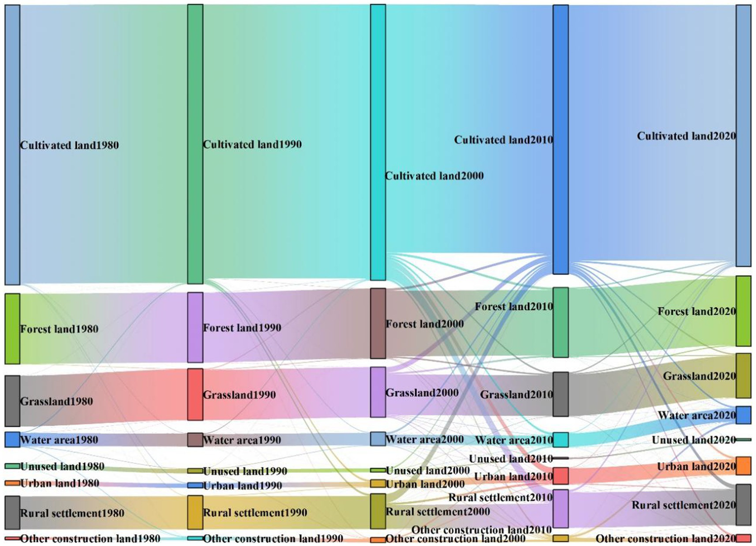
Land use change in the North China Plain from 1980 to 2020.
Over the past four decades, the area of urban land on the North China Plain has consistently expanded. Specifically, in 1980, the urban land area was 5.07 × 10³ km2, accounting for only 0.94% of the total land area of the North China Plain. By 1990, this figure had increased to 5.76 × 10³ km2, representing 1.07% of the total area. In 2000, the urban land area further surged to 8.85 × 10³ km2, comprising 1.65% of the total area. By 2010, urban land area had dramatically increased to 1.97 × 10⁴ km2, making up 3.68% of the total area. In 2020, the area continued to expand, reaching 2.09 × 10⁴ km2, which accounted for 3.89% of the total land area. In terms of land source, between 1980 and 1990, the primary contributor to the increase in urban land was the conversion of arable land. From 1990 to 2010, both arable land and rural residential areas collectively contributed to the expansion of urban land. Even during the 2010–2020 period, arable land continued to play a pivotal role in this transformation. Similarly, the area of rural residential land also exhibited a growing trend, with its main sources being arable land and grassland. Notably, the increase in water bodies over these four decades was relatively modest, primarily originating from arable land and other construction land.
4.2 Urban land expansion and cultivated land occupation from 1980 to 2020
4.2.1 Temporal and spatial distribution
Between 1980 and 2020, the urban land area of the North China Plain expanded by 1.59 × 10⁴ km2, with a substantial 1.33 × 10⁴ km2, or 83.85%, of this increase occurring at the expense of cultivated land (Figure 3). This dramatic shift highlights the growing pressure on agricultural resources due to urbanization. The temporal distribution of urban land expansion was marked by significant increases in the following periods: 647.80 km2 from 1980 to 1990, 2.37 × 10³ km2 from 1990 to 2000, 7.76 × 10³ km2 from 2000 to 2010, and 2.54 × 10³ km2 from 2010 to 2020. Notably, the data reveal considerable spatial heterogeneity in the consumption of cultivated land across the North China Plain. Urban expansion predominantly concentrated around provincial capitals, forming high-density urban zones that gradually extended outward in a contiguous pattern. Conversely, in more peripheral regions, urbanization manifested in a fragmented and dispersed manner.
Figure 3
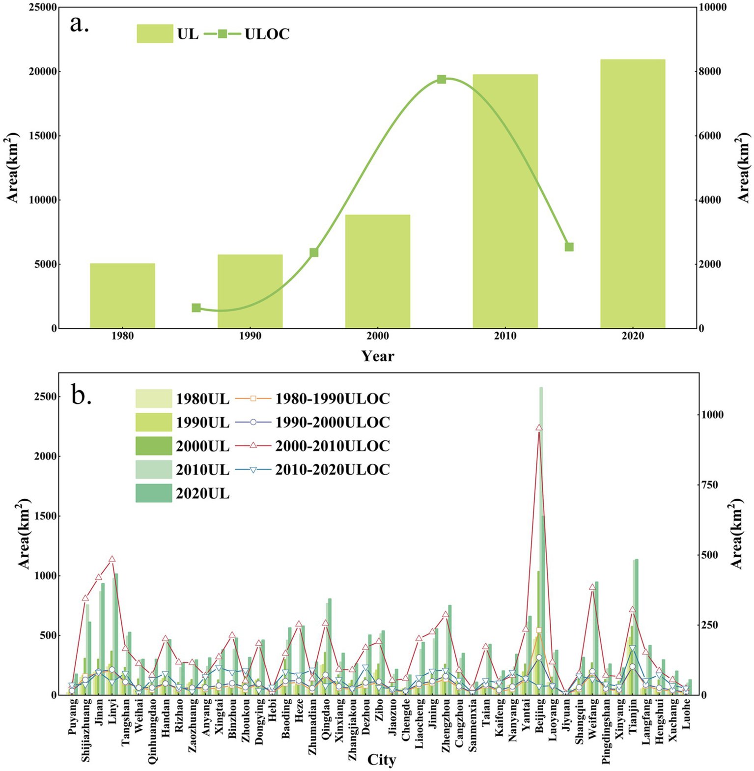
Changes in urban land area and cultivated land occupation due to urban expansion in the North China Plain (a) overall and (b) by city, 1980–2020.
In terms of the scale of urban expansion, Beijing (1.03 × 10³ km2), Weifang (795.03 km2), and Linyi (778.55 km2) experienced the most substantial growth. These cities were followed by Jinan (742.15 km2), Tianjin (675.61 km2), and Zhengzhou (613.39 km2). By contrast, Jiyuan (34.43 km2) and Sanmenxia (67.12 km2) exhibited the smallest increases in urban land area.
Over time, the spatial dynamics of agricultural land consumption driven by urban expansion have experienced notable transformations (Figure 4). From 1980 to 1990, the cities exhibiting the highest levels of agricultural land consumption due to urban growth included Weifang (55.88 km2), Tangshan (42.71 km2), and Zhengzhou (30.46 km2), the majority of which were provincial capitals or cities in close proximity to them. Between 1990 and 2000, the focus of urban expansion shifted to Beijing (394.84 km2), Baoding (119.49 km2), and Shijiazhuang (110.97 km2), with these cities predominantly concentrated in Hebei Province and the Beijing metropolitan region. From 2000 to 2010, the cities with the most substantial agricultural land consumption were again Beijing (952.85 km2), Linyi (484.02 km2), and Jinan (419.17 km2), with these urban centers remaining predominantly in the Beijing-Shandong corridor. However, from 2010 to 2020, the cities exhibiting the highest rates of agricultural land consumption included Tianjin (170.69 km2), Dezhou (101.09 km2), and Xingtai (99.28 km2), with these areas reflecting a more dispersed and peripheral expansion.
Figure 4
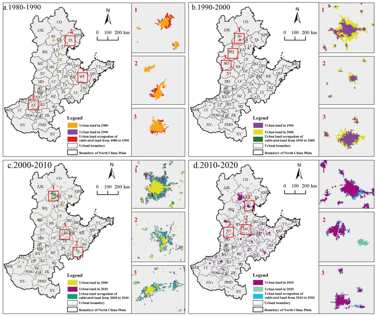
Spatial distribution of cultivated land occupation due to urban expansion in the North China Plain, 1980–2020.
A comparative analysis of agricultural land consumption across these four periods reveals a consistent pattern: provincial capitals remain dominant in high-value zones, with their influence gradually extending to surrounding cities. In contrast, more peripheral regions of the North China Plain exhibit markedly lower levels of agricultural land consumption as a result of urban expansion, particularly when compared to the central regions.
4.2.2 Expansion rate
Between 1980 and 2020, urban expansion in the North China Plain displayed notable temporal and spatial variations in agricultural land consumption. Overall, expansion was markedly more rapid in proximity to provincial capitals, whereas peripheral regions experienced comparatively slower growth, resulting in a “high in the center, low at the periphery” trend of urbanization (Figure 5). Specifically, from 1980 to 1990, the city exhibiting the highest rate of agricultural land consumption due to urban growth was Weifang, with an annual rate of 5.59 km2/year. It was followed by Tangshan and Zhengzhou, with annual consumption rates of 4.27 km2/year and 3.04 km2/year, respectively. In contrast, urban expansion in the northern and southwestern sectors of the North China Plain was relatively subdued during this period. From 1990 to 2000, the locus of urban land consumption shifted to Beijing, which saw an annual consumption rate of 39.48 km2/year. Baoding and Shijiazhuang also experienced relatively rapid urban expansion, with annual rates of 11.95 km2/year and 11.10 km2/year, respectively. The central region of the North China Plain exhibited moderate growth, while Chengde registered the slowest expansion, with an annual consumption rate of merely 0.30 km2/year. Between 2000 and 2010, Beijing retained its position as the leader in urban land consumption within the region, with an extraordinary annual rate of 95.28 km2/year. Conversely, the slowest urban expansion occurred in Jiyuan, Henan, with the lowest rate of 0.64 km2/year. From 2010 to 2020, Tianjin emerged as the city with the most rapid urban land consumption, with an annual rate of 17.07 km2/year. The central and southern regions of the North China Plain also experienced relatively swift urban growth during this period, while Jiyuan maintained its position as the city with the slowest expansion, at an annual rate of 0.53 km2/year.
Figure 5
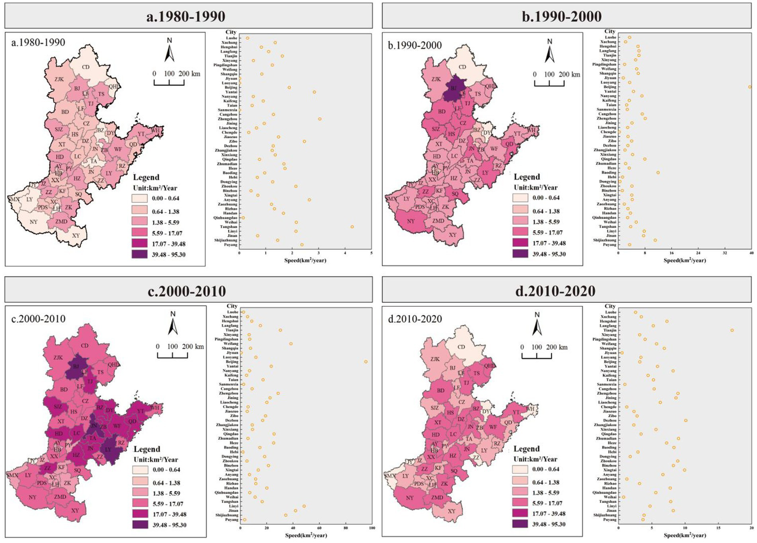
The rate of urban expansion and cultivated land occupation in the North China Plain from 1980 to 2020.
4.2.3 Expansion intensity
Between 1980 and 2020, the intensity of urban encroachment on agricultural land in the North China Plain demonstrated an overall increasing trajectory, followed by a gradual deceleration. Notable fluctuations in expansion intensity were observed across different temporal periods and urban centers (Figure 6). During the 1980–1990 period, Sanmenxia exhibited the highest expansion intensity, with an intensity index of 0.8. In contrast, cities located in the northern regions of the North China Plain experienced the lowest expansion intensities in terms of agricultural land consumption. Between 1990 and 2000, a dramatic shift in urban land consumption intensity occurred. Sanmenxia maintained its position as the city with the highest expansion intensity, reaching an index of 0.10, while Dongying recorded the lowest intensity at 0.05. From 2000 to 2010, the disparities in expansion intensity became more pronounced. Jiyuan demonstrated the strongest expansion intensity with a value of 0.11, while Tianjin exhibited the weakest expansion intensity, at 0.06. In the final period, from 2010 to 2020, the spatial pattern of agricultural land consumption underwent another transformation. Tianjin emerged as the city with the highest expansion intensity, with an index of 1.97, followed by Handan, which had an intensity index of 1.63. Conversely, Beijing recorded the lowest expansion intensity, with an index of only 0.003.
Figure 6
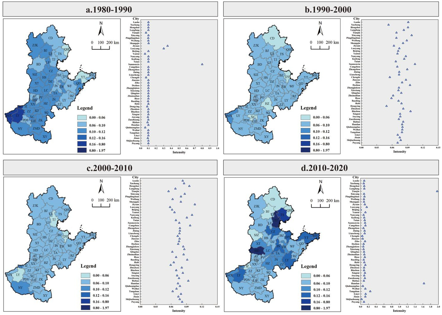
The intensity of urban expansion occupying farmland in the North China Plain from 1980 to 2020.
4.3 Loss of agricultural production potential due to urban land expansion on cultivated land
Between 1980 and 2020, urban expansion on agricultural land in the North China Plain was accompanied by a discernible increase in food production loss, exhibiting a spatial distribution pattern characterized by “lower losses in the north, higher losses in the central and southern regions” (Figure 7). Overall, urban encroachment resulted in a cumulative food production loss of 7.03 × 10⁹ kg. Specifically, from 1980 to 1990, the food production loss totaled 1.50 × 10⁸ kg; from 1990 to 2000, it increased to 5.72 × 10⁸ kg; between 2000 and 2010, the loss surged to 4.08 × 10⁹ kg; and from 2010 to 2020, the loss reached 2.22 × 10⁹ kg.
Figure 7
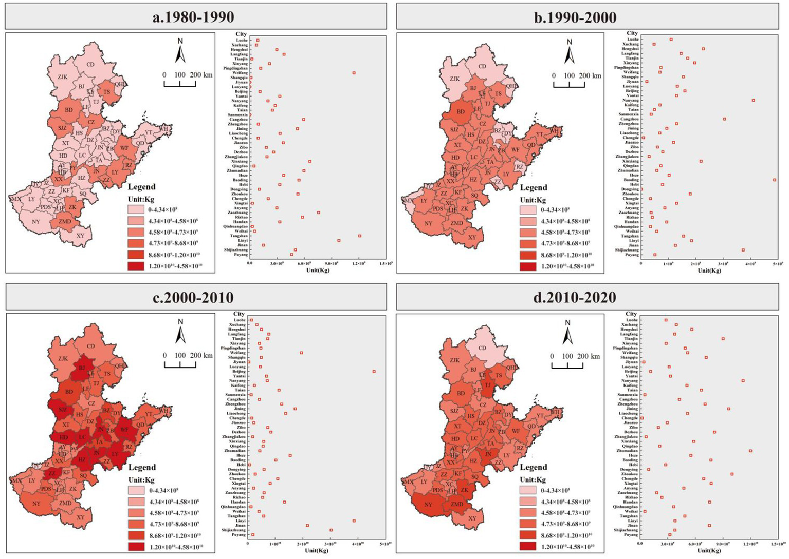
Agricultural production loss induced by urban expansion on cultivated land in the North China Plain (1980–2020).
During the 1980–1990 period, the greatest food production losses occurred in Tangshan, Hebei Province, where the recorded loss amounted to 1.21 × 10⁷ kg (Figure 7). Weifang, in Shandong Province, also experienced considerable losses, though lower than Tangshan’s, with a loss of 1.15 × 10⁷ kg. Other cities in the region reported more modest agricultural production losses. From 1990 to 2000, the loss of agricultural production potential increased significantly, with notable regional variations. The Beijing-Tianjin-Hebei region, along with the southern portion of the North China Plain, particularly Henan Province, became prominent high-loss zones, with Baoding recording the largest loss of 4.87 × 10⁷ kg. Conversely, the northern parts of the North China Plain, particularly the central regions, experienced significantly lower losses.
Between 2000 and 2010, agricultural production losses escalated rapidly (Figure 7). During this period, the central region of the North China Plain emerged as the primary zone of high agricultural production losses. Beijing accounted for the largest loss, totaling 4.58 × 10⁸ kg, followed by Linyi with a loss of 3.86 × 10⁸ kg. In contrast, Jiyuan, situated in the southern part of the North China Plain, reported the smallest loss, amounting to just 4.34 × 10⁶ kg. From 2010 to 2020, the areas of highest food production losses were concentrated in the central and southern regions of the North China Plain. Zhumadian recorded the largest loss at 1.20 × 10⁸ kg, followed closely by Nanyang with a loss of 1.12 × 10⁸ kg. In contrast, Chengde, located in the northern part of the North China Plain, experienced the lowest loss, with a total of only 2.38 × 10⁶ kg.
5 Discussion
5.1 Analysis of the drivers of urban expansion and cultivated land occupation
With the growth of population and the acceleration of urbanization, the demand for residential, commercial, transportation, and other infrastructure has steadily increased, driving the outward expansion of urban areas and resulting in the conversion of large tracts of cultivated land to meet the needs of urban development (Ye et al., 2020; Zhao and Yin, 2023). As one of the most economically developed and densely populated regions in China, the North China Plain has experienced a particularly pronounced urbanization process, making the issue of cultivated land occupation even more pressing and warranting detailed investigation (Liu et al., 2018).
The drivers of urban expansion on cultivated land are multifaceted and complex, encompassing a range of factors, including natural geography, transportation infrastructure, and socioeconomic conditions (Li et al., 2018; Wu et al., 2021). From a natural conditions perspective, the North China Plain, located in the eastern coastal region of China, is characterized by flat terrain, fertile soil, and a favorable climate, making it a vital agricultural zone. However, these advantageous natural factors also facilitate urban expansion, reducing geographic constraints on construction activities and thus exacerbating the occupation of arable land (Tu et al., 2023). Moreover, the high agricultural productivity in this region makes its land more prone to being converted into urban uses, such as residential, commercial, and transportation infrastructure, during the course of urban development. While this urbanization has yielded significant economic benefits, it has also posed challenges to agricultural production and food security.
In addition, certain key cities in the North China Plain, such as Beijing and Tianjin, as political, economic, and transportation hubs of national significance, have contributed further to the intensification of cultivated land occupation in surrounding areas. Economic development remains one of the primary drivers of urban expansion (Feng and Kaiyong, 2021; Li and Hong, 2022). With the rapid growth of industries such as manufacturing, commerce, and services, the demand for land has continued to surge, leading to the conversion of large areas of cultivated land for industrial parks, commercial zones, and logistics hubs.
Moreover, government policies and urban planning initiatives also play a critical role in the conversion of agricultural land (Wu et al., 2024). To promote regional economic growth and enhance urbanization, governments often implement policies and urban plans that steer cities toward specific growth directions. While these policies accelerate the urbanization process, they also contribute to the transformation of vast areas of cultivated land into urban construction zones, which has profound implications for regional land use patterns and ecosystem services.
5.2 Comparison with existing research
In contrast to existing studies that predominantly emphasize the quantitative loss of cropland driven by urban expansion, this study provides a more comprehensive perspective by extending the analytical framework in terms of research lens, methodological approach, and policy implications. Firstly, from the perspective of research focus, prior studies have largely centered on the reduction in cropland area while neglecting the spatial variability of land quality and its potential influence on food production capacity (Seto et al., 2012). By incorporating the indicator of potential crop yield, this study highlights the preferential conversion of high-yield farmland during urban expansion, thereby addressing the limitations of area-based assessments and enriching the understanding of land-use change impacts. Secondly, with respect to methodology, although regional disparities in expansion speed and intensity have been discussed in earlier research, their linkages to the degradation of cropland quality remain insufficiently examined (Hu et al., 2018; Zhong et al., 2020). This study adopts a city-level analytical scale and proposes a composite evaluation framework integrating expansion speed, expansion intensity, and yield potential loss, enabling a nuanced exploration of the spatial heterogeneity in production capacity depletion under different urban expansion patterns. Finally, in terms of policy relevance, existing research often offers qualitative insights into the threats posed by urban growth to food security, but lacks quantitative metrics to inform decision-making (Li et al., 2017). By quantifying potential yield losses across cities and time periods—for instance, a loss of 1.21 × 10⁷ kg in Tangshan from 1980 to 1990—this study offers actionable evidence for cultivated land protection, urban growth boundary delineation, and national spatial planning optimization.
5.3 Limitations and future directions
This study has several limitations that should be acknowledged. First, discrepancies in spatial resolution between the land use data and the farmland productivity dataset may introduce uncertainties in the assessment of crop yield loss due to urban expansion. To address this issue, resampling was performed on both datasets, which may have influenced the precision of the estimated yield loss. Second, to control for confounding variables and more accurately capture the spatiotemporal effects of urban expansion on agricultural productivity, this study relies on a single-period farmland productivity dataset. However, this approach does not fully account for temporal variations and technological advancements that may contribute to yield improvements over time. Lastly, the farmland productivity dataset represents an estimated value, and the modeling framework employed in this study adopts certain simplifications, omitting complex environmental factors such as soil degradation. These limitations underscore the need for future research to enhance data resolution, incorporate long-term temporal dynamics, and refine methodological approaches to improve the robustness and applicability of findings for sustainable land use planning and food system resilience.
5.4 Policy implications
The speed, intensity, and impact of urban expansion on cultivated land in the North China Plain are influenced by a complex interplay of natural geographical conditions, socio-economic development, and transportation infrastructure. Based on a systematic analysis of urban land expansion speed, intensity, and the resulting food production loss in the North China Plain between 1980 and 2020, this study reveals that regions characterized by slower urban expansion and lower intensity of land occupation typically experience less significant agricultural production potential loss. To effectively mitigate the loss of agricultural production potential in the North China Plain, the following policy recommendations are proposed from both economic and regional perspectives, tailored to areas with varying expansion speeds and intensities:
In regions with rapid urban land expansion and high intensity (e.g., Weifang, Beijing, and Baoding), significant agricultural production potential losses are mainly attributed to large-scale land conversion driven by rapid urbanization (Song et al., 2015; Liyan et al., 2019). This conversion directly reduces the area available for food cultivation, thereby threatening regional food security and posing potential risks to the national food supply system (Harris et al., 2022; Wassenius et al., 2023). To address these challenges, urbanization scales and spatial layouts should be scientifically planned according to the region’s resource and environmental carrying capacity. Specific measures include: stringent protection of the “red line” for arable land to prevent excessive concentration and unregulated urban sprawl; strengthening land approval and regulatory systems to promote land-saving and intensive land use; and improving land use efficiency through policy-driven optimization of land resource allocation. Additionally, regional cooperation should be enhanced to promote the synergistic implementation of regional development plans and policies, facilitating complementary resource advantages (Wu et al., 2022). For instance, the establishment of agricultural cooperation mechanisms, the promotion of agricultural technological innovation, and the development of modern agriculture can help increase food production per unit area, partially compensating for the agricultural production potential lost due to the reduction in arable land (Nordin et al., 2022; Huang et al., 2024; Xiong et al., 2024).
In contrast, areas with slower urban land expansion and lower intensity (such as Jiyuan and Chengde) exhibit relatively minor losses in agricultural production potential. These regions have managed to maintain a better balance between economic development and arable land protection, thereby ensuring stability in food production (Dai et al., 2024). However, these regions must remain vigilant and continue to strengthen the enforcement of arable land protection policies to mitigate potential risks associated with accelerated urbanization in the future.
Moreover, under the framework of the “cultivated land occupation and compensation balance” policy, it is essential to consider the complexity of various factors, including the quantity, quality, ecological value, spatial distribution, and temporal aspects of cultivated land. In the next phase, efforts should focus on enhancing the integration of regional economic development land-use planning, adjustments to cultivated land spatial layouts, and agricultural structure reform, while refining policy designs. Key recommendations include: establishing a technical system for evaluating land quality and ecological construction standards, developing a rigorous land quality inspection mechanism for newly converted land, and improving systems and procedures for guiding social participation in land protection. Additionally, in the context of high-standard farmland construction and the unified national land spatial planning (“One Map”), it is vital to clearly demarcate the arable land “red line” and, where appropriate, introduce ecological buffer zones to create pollution barriers for arable land. These integrated measures will ensure the sustainable use of cultivated land resources in the North China Plain, achieving a harmonious balance between urbanization and food security.
6 Conclusion
An in-depth examination of the relationship between urban expansion, farmland loss, and agricultural productivity potential on the North China Plain is pivotal for optimizing land resource management, ensuring sustainable land use, and safeguarding food security, particularly within the context of rapid socio-economic development. Leveraging the Chinese multi-temporal land use remote sensing monitoring dataset (CNLUCC) alongside agricultural productivity potential data, this study presents the following key findings:
(1) Marked expansion of urban land on the north china plain.
Between 1980 and 2020, urban land on the North China Plain experienced substantial growth, with an expansion of 15,800 km2, of which 12,500 km2 was converted from arable land. Urbanization predominantly generated high-density zones centered around provincial capitals, gradually expanding outward in a patchwork-like pattern. This continuous urban spread has progressively encroached upon surrounding arable land, posing potential risks to regional food production security.
(2) Significant spatial variability in the rate of urban expansion on farmland.
Between 1980 and 2020, urban expansion in the North China Plain exhibited pronounced spatial variations in the rate of agricultural land consumption, reflecting a pattern of “higher rates at the center, lower rates at the periphery.” Throughout the study period, the city with the highest rate of agricultural land consumption was Beijing, with an annual consumption rate of 95.28 km2/year between 2000 and 2010, followed by a rate of 39.48 km2/year from 1990 to 2000. In contrast, Jiyuan recorded the slowest rate of agricultural land consumption between 1980 and 1990, with a minimal annual consumption rate of just 0.0006 km2/year.
(3) Phased changes in the intensity of urban expansion on arable land.
Between 1980 and 2020, the intensity of urban encroachment on agricultural land in the North China Plain exhibited a discernible trend of gradual increase followed by a deceleration. Specifically, from 1980 to 1990, Sanmenxia exhibited the highest expansion intensity, with an intensity index of 0.8. From 1990 to 2000, Sanmenxia continued to demonstrate the strongest expansion intensity, reaching 0.10, while Dongying recorded the lowest intensity at 0.05. Between 2000 and 2010, Jiyuan recorded the highest expansion intensity at 0.11, whereas Tianjin exhibited the weakest expansion intensity at 0.06. Finally, from 2010 to 2020, Tianjin emerged as the city with the highest expansion intensity, with an intensity index of 1.97, while Beijing experienced the lowest intensity, with a value of merely 0.003.
(4) Impact of urban expansion on agricultural productivity potential.
The speed and intensity of urban expansion are positively correlated with the loss of agricultural productivity potential. The findings highlight that urban expansion in cities such as Tangshan, Baoding, Beijing, and Zhumadian has had a particularly profound impact on both arable land and agricultural productivity. For instance, between 1980 and 1990, Tangshan experienced a loss of 1.21 × 10⁷ kg in agricultural productivity, while Baoding saw a loss of 4.87 × 10⁷ kg from 1990 to 2000. In contrast, cities like Jiyuan and Chengde faced relatively smaller direct losses to food production, at 4.34 × 10⁶ kg and 2.38 × 10⁶ kg, respectively. However, should urban expansion continue unchecked, the potential threats to regional food production will intensify. In the long run, ensuring food security on the North China Plain remains a critical and daunting challenge.
Statements
Data availability statement
The original contributions presented in the study are included in the article/Supplementary material, further inquiries can be directed to the corresponding author.
Author contributions
SS: Writing – Original draft. JH: Funding acquisition, Project administration, Resources, Supervision, Validation, Visualization, Writing – review & editing.
Funding
The author(s) declare that financial support was received for the research and/or publication of this article. This study was supported by 2023 Ningxia Business Environment Third Party Evaluation and Monitoring Project, E4M40700.
Conflict of interest
The authors declare that the research was conducted in the absence of any commercial or financial relationships that could be construed as a potential conflict of interest.
Generative AI statement
The authors declare that no Gen AI was used in the creation of this manuscript.
Publisher’s note
All claims expressed in this article are solely those of the authors and do not necessarily represent those of their affiliated organizations, or those of the publisher, the editors and the reviewers. Any product that may be evaluated in this article, or claim that may be made by its manufacturer, is not guaranteed or endorsed by the publisher.
Supplementary material
The Supplementary material for this article can be found online at: https://www.frontiersin.org/articles/10.3389/fsufs.2025.1545907/full#supplementary-material
References
1
Bren d’AmourC.ReitsmaF.BaiocchiG.BarthelS.GüneralpB.ErbK. H.et al. (2016). Future urban land expansion and implications for global croplands. Proc. Natl. Acad. Sci. USA:8939.
2
Cansino-LoezaB.del Carmen Munguia-LopezA.Maria Ponce-OrtegaJ. (2022). A water-energy-food security nexus framework based on optimal resource allocation. Environ. Sci. Pol.133, 1–16. doi: 10.1016/j.envsci.2022.03.006
3
DaiZ.-Z.ChangS.ZhuZ.-Y.DuanJ.-J.JiangT.-Y.WuW.-Q.et al. (2024). Assessment and multiscenario simulation of land use and ecosystem services interactions in Inner Mongolia. Land Degrad. Dev.35, 5611–5625. doi: 10.1002/ldr.5319
4
FengR.KaiyongW. (2021). Spatiotemporal effects of administrative division adjustment on urban expansion in China. Land Use Policy101:105143. doi: 10.1016/j.landusepol.2020.105143
5
HarrisF.AmarnathG.JoyE. J. M.DangourA. D.GreenR. F. (2022). Climate-related hazards and Indian food supply: assessing the risk using recent historical data. Global Food Security33:100625. doi: 10.1016/j.gfs.2022.100625
6
HemmavanhC.YeY.YoshidaA. (2010). Forest land use change at trans-boundary Laos-China biodiversity conservation area. J. Geogr. Sci.20, 889–898. doi: 10.1007/s11442-010-0818-1
7
HuY.KongX.ZhengJ.SunJ.WangL.MinM. (2018). Urban expansion and farmland loss in Beijing during 1980-2015. Sustain. For.10:3927. doi: 10.3390/su10113927
8
HuangQ.GuoW.WangY. (2024). A study of the impact of new quality productive forces on agricultural modernization: empirical evidence from China. Agriculture14:1935. doi: 10.3390/agriculture14111935
9
KeX.van VlietJ.ZhouT.VerburgP. H.ZhengW.LiuX. (2018). Direct and indirect loss of natural habitat due to built-up area expansion: A model-based analysis for the city of Wuhan, China. Land Use Policy74, 231–239. doi: 10.1016/j.landusepol.2017.12.048
10
LiQ.HongL. (2022). Spatiotemporal variation and driving factors analysis on the expansion of the main urban agglomerations in China. J. Intell. Fuzzy Syst.43, 4145–4159. doi: 10.3233/JIFS-220201
11
LiG.SunS.FangC. (2018). The varying driving forces of urban expansion in China: insights from a spatial-temporal analysis. Landsc. Urban Plan.174, 63–77. doi: 10.1016/j.landurbplan.2018.03.004
12
LiW.WangD.LiH.LiuS. (2017). Urbanization-induced site condition changes of peri-urban cultivated land in the black soil region of Northeast China. Ecol. Indic.80, 215–223. doi: 10.1016/j.ecolind.2017.05.038
13
LiX.WuK.ZhaoR.LiuY.LiX.YangQ. (2021). Spatial analysis of cultivated land productivity and health condition: A case study of Gaoping City, China. Land10:10. doi: 10.3390/land10121296
14
LiS.ZhuC.DengX. (2024). Exploring the urban-rural gradient effects of construction land expansion processes on land use function trade-off/synergy in rapidly urbanizing areas. Land Degrad. Dev.35, 46–61. doi: 10.1002/ldr.4896
15
LiuX.LiX.ZhangY.WangY.ChenJ.GengY. (2023). Spatiotemporal evolution and relationship between construction land expansion and territorial space conflicts at the county level in Jiangsu Province. Ecol. Indic.154:110662. doi: 10.1016/j.ecolind.2023.110662
16
LiuY. R.WangC.YanL. J. (2018). Impacts of land use change on ecosystem services in the agricultural area of North China plain: a case study of Shangqiu City, Henan Province, China. J. Appl. Ecol.29, 1597–1606.
17
LiuL.XuX.ChenX. (2014). Assessing the impact of urban expansion on potential crop yield in China during 1990–2010. Food Secur.
18
LiyanW.HerzbergerA.LiyunZ.YiX.YaqingW.YangX.et al. (2019). Spatial and temporal changes of arable land driven by urbanization and ecological restoration in China. Chin. Geogr. Sci.
19
NicolasW.CeciliaC.HernanA.MercedesE.GastonL.WalterC.et al. (2022). The effect of agriculture on topsoil carbon stocks is controlled by land use, climate, and soil properties in the Argentinean pampas. Catena212:106126. doi: 10.1016/j.catena.2022.106126
20
NordinS. M.ZolkepliI. A.RizalA. R. A.TariqR.MannanS.RamayahT. (2022). Paving the way to paddy food security: a multigroup analysis of agricultural education on circular economy adoption. J. Clean. Prod.375:134089. doi: 10.1016/j.jclepro.2022.134089
21
QuY.ZhanL.WeiC.ZhangQ.WangJ. (2024). Interactive transition of cultivated land and construction land during china's urbanization: a coordinated analytical framework of explicit and implicit forms. Land Use Policy138:107049. doi: 10.1016/j.landusepol.2024.107049
22
RuiqiW.HongL. I.YiS. (2023). Change of cultivated land area and effect on ecosystem service in black soil region in Northeast China: a case study of Lishu County, Jilin Province. World Geol.26, 251–263.
23
SetoK. C.GueneralpB.HutyraL. R. (2012). Global forecasts of urban expansion to 2030 and direct impacts on biodiversity and carbon pools. Proc. Natl. Acad. Sci. USA109, 16083–16088. doi: 10.1073/pnas.1211658109
24
ShengS.SongW.LianH.NingL. (2022). Review of urban land management based on bibliometrics. Land11:1968. doi: 10.3390/land11111968
25
SongW.PijanowskiB. C.TayyebiA. (2015). Urban expansion and its consumption of high-quality farmland in Beijing, China. Ecol. Indicators Integrat. Monitor. Assess. Manag.54, 60–70. doi: 10.1016/j.ecolind.2015.02.015
26
TilahunZ. A.BizunehY. K.MekonnenA. G. (2024). A spatio-temporal analysis of the magnitude and trend of land use/land cover changes in Gilgel gibe catchment, Southwest Ethiopia. Heliyon10:e24416. doi: 10.1016/j.heliyon.2024.e24416
27
TuY.ChenB.YuL.SongY.WuS.LiM.et al. (2023). Raveling the nexus between urban expansion and cropland loss in China. Landsc. Ecol.38, 1869–1884. doi: 10.1007/s10980-023-01653-7
28
WangG. M.SalmanM. (2023). The driving influence of multidimensional urbanization on green total factor productivity in China: evidence from spatiotemporal analysis. Environ. Sci. Pollut. Res.30, 52026–52048. doi: 10.1007/s11356-023-25864-2
29
WasseniusE.PorkkaM.NystromM.JorgensenP. S. (2023). A global analysis of potential self-sufficiency and diversity displays diverse supply risks. Global Food Security37:100673. doi: 10.1016/j.gfs.2023.100673
30
WuC.JiangA.-d.ZhengW. (2022). Study on the measures for optimizing China's provincial territorial space based on the perspective of resource and environmental carrying capacity in the new situation. Sustain. For.14:13754. doi: 10.3390/su142113754
31
WuR.LiZ.WangS. (2021). The varying driving forces of urban land expansion in China: insights from a spatial-temporal analysis. Sci. Total Environ.766:142591. doi: 10.1016/j.scitotenv.2020.142591
32
WuX.ZhaoN.WangY.ZhangL.WangW.LiuY. (2024). Cropland non-agriculturalization caused by the expansion of built-up areas in China during 1990–2020. Land Use Policy146:107312. doi: 10.1016/j.landusepol.2024.107312
33
XiaoL.DengQ.LinY.MaoY.LiuJ. (2021). Research on coordinated development between cultivated land protection and construction land intensive use under the background of new-style urbanization. Chinese J. Agric. Resour. Regional Plan.42:10. doi: 10.7621/cjarrp.1005-9121.20210907
34
XiongC.ZhangY.WangW. (2024). An evaluation scheme driven by science and technological innovation-a study on the coupling and coordination of the agricultural science and technology innovation-economy-ecology complex system in the Yangtze River basin of China. Agriculture14:1844. doi: 10.3390/agriculture14101844
35
XuX.LiuJ.ZhangS.LiR.YanC.WuS.China multi-period land use and land cover remote sensing monitoring dataset (CNLUCC). Chinese Acad. Sci. doi: 10.12078/2018070201
36
YeS.SongC.ShenS.GaoP.ZhuD. (2020). Spatial pattern of arable land-use intensity in China. Land Use Policy99:104845. doi: 10.1016/j.landusepol.2020.104845
37
YinY.TangQ.LiuX.ZhangX. (2017). Water scarcity under various socio-economic pathways and its potential effects on food production in the Yellow River basin. Hydrol. Earth Syst. Sci.21, 791–804. doi: 10.5194/hess-21-791-2017
38
YuZ.DengX. (2022). Assessment of land degradation in the North China Plain driven by food security goals. Ecol. Eng.183:106766. doi: 10.1016/j.ecoleng.2022.106766
39
YuW.YueY.WangF. (2022). The spatial-temporal coupling pattern of grain yield and fertilization in the North China Plain. Agric. Syst.196:103330. doi: 10.1016/j.agsy.2021.103330
40
ZhaoS.YinM. (2023). Change of urban and rural construction land and driving factors of arable land occupation. PLoS One18:e0286248. doi: 10.1371/journal.pone.0286248
41
ZhaoY.ZhangM.CuiJ. (2022). Land-use transition and its driving forces in a minority mountainous area: a case study from Mao County, Sichuan Province, China. Environ. Monit. Assess.194:688. doi: 10.1007/s10661-022-10289-0
42
ZhongY.LinA.HeL.ZhouZ.YuanM. (2020). Spatiotemporal dynamics and driving forces of urban land-use expansion: a case study of the Yangtze River Economic Belt, China. Remote Sens.12:287. doi: 10.3390/rs12020287
43
ZhouT.YangX.KeX. (2022). Delimitation of urban growth boundaries by integratedly incorporating ecosystem conservation, cropland protection and urban compactness. Ecol. Model.468:109963. doi: 10.1016/j.ecolmodel.2022.109963
Summary
Keywords
urban expansion, farmland loss, potential yield, food security, North China Plain
Citation
Sheng S and Huang J (2025) Urban expansion and the loss of potential crop yield in the North China Plain: implications for regional food security (1980–2020). Front. Sustain. Food Syst. 9:1545907. doi: 10.3389/fsufs.2025.1545907
Received
16 December 2024
Accepted
28 April 2025
Published
15 May 2025
Volume
9 - 2025
Edited by
Xueru Zhang, Hebei University of Economics and Business, China
Reviewed by
Shicheng Li, China University of Geosciences Wuhan, China
Jianjun Zhang, China University of Geosciences, China
Zijun Li, Shandong Normal University, China
Updates
Copyright
© 2025 Sheng and Huang.
This is an open-access article distributed under the terms of the Creative Commons Attribution License (CC BY). The use, distribution or reproduction in other forums is permitted, provided the original author(s) and the copyright owner(s) are credited and that the original publication in this journal is cited, in accordance with accepted academic practice. No use, distribution or reproduction is permitted which does not comply with these terms.
*Correspondence: Jinchuan Huang, huangjc@igsnrr.ac.cn
Disclaimer
All claims expressed in this article are solely those of the authors and do not necessarily represent those of their affiliated organizations, or those of the publisher, the editors and the reviewers. Any product that may be evaluated in this article or claim that may be made by its manufacturer is not guaranteed or endorsed by the publisher.