 Fan Liu
 Weiyan Hu1*
- 1College of Public Administration, Huazhong Agricultural University, Wuhan, China
- 2College of Resources and Environment, Henan University of Economics and Law, Zhengzhou, China
Understanding the influence mechanisms of road networks on cultivated land multifunctionality (CLM) is critical for optimizing territorial spatial patterns and achieving sustainable cultivated land resource management. This study considers the mediating role of cultivated land fragmentation (CLF) and constructs an analytical framework of “road networks–CLF–CLM” to investigate the impact of road network accessibility and transfer capacity on CLM in Hubei Province from 2013 to 2022. The results show that: (1) The enhancement of road network accessibility and transfer capacity significantly improved the overall level of CLM, promoting production function and landscape cultural function but inhibiting ecological function. (2) CLF plays a masking role in the relationship between road networks and CLM, weakening the positive impact of road networks on the overall CLM. Specifically, CLF exerted negative effects on production function and ecological function but a positive effect on landscape cultural function. (3) The influence of road networks on CLM exhibits variability across major function-oriented zones (MFOZs). These findings provide a theoretical basis for collaborative among transportation, territorial, and agricultural departments to develop differentiated road network optimization plans and zoning strategies for CLF management, thereby promoting synergistic enhancement of CLM.
1 Introduction
Road construction (e.g., building all-weather roads), as a key agenda item of the United Nations Sustainable Development Goals (SDGs), has become a priority infrastructure strategy for numerous countries and regions worldwide. As of 2022, the global road network totaled over 36 million kilometers, with an additional 25 million kilometers projected to be added by 2050 (Laurance et al., 2014; Microsoft, 2022). While the expansion of road networks contributes to increased household income, rural–urban integration, and common prosperity (Lu et al., 2022a), it simultaneously encroaches directly and indirectly upon cultivated land resources (Xiao et al., 2018; Fieden, 2019), threatens food security (Chai et al., 2019), and degrades the ecological and social security functions of cultivated land (Yu et al., 2019). This poses significant challenges to the protection of CLM and sustainable agricultural and rural development. Against the backdrop of persistent global population growth, sharp biodiversity declines, and increasing extreme climate events, cultivated land’s multifunctional roles - encompassing food production, ecological conservation, climate regulation, and cultural recreation –are under unprecedented pressure. The sustainable protection and utilization of cultivated land multifunctionality are thus crucial for agricultural and rural development. Notably, multifunctionality exhibits distinct regional characteristics (Wilson, 2009). The combination of CLM types, developmental levels, and optimization strategies highly depends on regional resource endowments and developmental objectives (Jiang et al., 2020). Therefore, formulating differentiated road network planning and management strategies based on regional resource endowment characteristics to promote the multifunctional protection and utilization of cultivated land has emerged as a critical scientific issue and policy challenge. Addressing this challenge is essential for achieving sustainable management of cultivated land resources and reconciling economic development with conservation imperatives.
Current research has primarily focused on the positive and negative impacts of roads on specific functions of cultivated land. Examples include enhanced agricultural output (Tong et al., 2013) and agritourism development (Tang et al., 2022), or induced negative effects such as soil heavy metal pollution and biodiversity decline (Wu et al., 2014; Bennett, 2017; Kim et al., 2017). However, three critical research gaps remain inadequately addressed. First, road network characteristics are understudied. Current research on roads’ effects on cultivated land functions predominantly relies on socio-economic statistical data to represent road attributes (Tong et al., 2013; Tang et al., 2022), resulting in limited attention to detailed road network characteristics. Second, the underlying mechanism remains unclear. As physical landscape elements, road networks fragment and occupy cultivated land, leading to CLF (Asadi et al., 2016; Xiao et al., 2018). CLF is significantly linked to the manifestation of cultivated land’s production, ecological, and landscape cultural functions (Fathi and Masnavi, 2014; Looga et al., 2018; Pu et al., 2024). Crucially, however, the specific pathway through which road networks influence CLM via CLF has not been explicitly investigated or reported. Third, regional heterogeneity is insufficiently explored. Although studies have examined the influence of road density and proximity on CLM (Gong et al., 2022; Fan et al., 2023), and investigated the heterogeneity of factors affecting cultivated land functions across MFOZs (Shi and Liu, 2023), a systematic analysis of the regional variability in road networks’ impact on CLM, particularly the differences between distinct MFOZs, is still lacking.
This study aims to explore the impact of road networks on the CLM, specifically focusing on the mediating mechanism of CLF, in order to narrow the research gap regarding the mechanisms through which road networks influences CLM, and attempt to address the following research questions: (1) Does the road network affect the CLM? (2) How does the road network affect CLM through the CLF? (3) Do the impacts of road networks on CLM vary across major function-oriented zones? First, we constructs a theoretical analysis framework “road networks - CLF - CLM,” through a literature review, and conducts an empirical examination using Hubei Province as a case study. As a major transportation hub and grain production base in China, Hubei Province has been facing multiple challenges in recent years, including road network expansion, reduction in cultivated land area, declining land quality, and degradation of ecological functions, providing a highly relevant real-world context for this research. Using the data of Hubei Province in 2013 and 2022, this study employ a fixed effect model to explore the impact of the road network on CLM, and a mediating effect model to quantify CLF’s mediating role, and grouped regression analyses to assess heterogeneity in impacts across MFOZs. The findings provide a scientific basis for optimizing road network planning and advancing CLM protection and utilization.
2 Literature review and mechanism analysis
2.1 Research on cultivated land multifunctionality assessment and influencing factors
Classification and quantitative assessment of cultivated land multifunctionality (CLM) form the foundation of research. Wilson (2009) emphasized that CLM exhibits regionally embedded characteristics, requiring classification based on specific socio-contextual settings. For instance, the European Union (EU), a major global grain producer, focuses on resource conservation, recreational spaces, and landscape cultural functions to avoid overproduction (Vos and Meekes, 1999). Japan, prone to natural disasters, prioritizes the disaster prevention and mitigation functions of cultivated land (Masuda et al., 2022). African nations place greater emphasis on functions like land-based food security, livelihood sustenance and improvement, and environmental protection (Simelton et al., 2019). Chinese scholars frequently categorize CLM into production, ecological, landscape cultural, and social security (livelihood support) functions (Fan et al., 2023; Liu et al., 2023). Despite variations in classification systems across regions and socio-economic contexts, a consensus exists on partitioning cultivated land functions into production, ecological, and landscape cultural dimensions. Building on this framework, researchers employ value-based (Liu et al., 2023) and comprehensive indicator methods (Jiang et al., 2020; Fan et al., 2023)to quantify CLM. Among these, the comprehensive indicator approach is widely adopted in CLM assessments due to its accessibility of data and computational simplicity. Utilizing this method, scholars have subsequently investigated the spatiotemporal evolution, supply–demand matching, and trade-off/synergy relationships of CLM (Zhang et al., 2021; Gong et al., 2022; Liu et al., 2023).
Cultivated land constitutes a complex system integrating natural and socio-economic elements, with its multifunctionality emerging from the integrated effects of these system components (Jiang et al., 2020; Zou et al., 2021). Consequently, investigating the drivers of CLM from the perspective of natural and socio-economic factor inputs has gained significant scholarly attention. Regarding natural factors, one strand of research focuses on internal elements such as temperature, precipitation, and soil type within the cultivated land system and their impact on CLM (Zhao et al., 2021). Another strand emphasizes landscape-level processes, examining complex ecological interactions among landscape elements. This approach aims to enhance CLM—particularly production and ecological functions—by optimizing landscape configuration around cultivated land to improve pollination services, biodiversity, microclimates, and hydrological conditions (Robinson et al., 2022; Xin et al., 2024). For socio-economic factors, some scholars explore micro-level agricultural practices, analyzing how fertilizer inputs affect both crop production functions and environmental functions like biodiversity and greenhouse gas emissions (Ullah et al., 2020). Others adopt a macro-policy perspective, examining the influences of urbanization, socio-economic development, and trade policy interventions on CLM (Moon, 2010; Yu et al., 2019; Shi and Liu, 2023). However, how natural and socio-economic factors interact synergistically to enhance CLM requires further exploration.
2.2 Road networks, cultivated land fragmentation, and cultivated land multifunctionality
As conduits for factor mobility, roads influence the spatial flow of input and output elements at both natural and socio-economic levels, thereby facilitating the manifestation of cultivated land functions. On the one hand, numerous studies recognize roads’ positive role in enabling the flow of socio-economic factors such as fertilizers, agricultural technologies, and machinery, contributing significantly to enhanced agricultural output and land use efficiency (Tong et al., 2013; Lu et al., 2022b). Tang et al. (2022) further demonstrated that roads facilitate urban–rural population mobility, increasing demand for agricultural open spaces, pastoral landscapes, and rural culture, thereby promoting agritourism development and elevating the landscape cultural function of cultivated land. Conversely, other literature examines the negative impacts of roads, including the dispersal and deposition of tire wear particles, fuel exhaust, and heavy metal dust, which detrimentally affect surrounding soil quality, farmland biodiversity, ecological integrity, and ecosystem services (Wu et al., 2014; Bennett, 2017; Kim et al., 2017; Zhou et al., 2020). While the aforementioned research primarily focuses on roads’ impacts on singular functions of cultivated land (production, ecology, or landscape culture), studies by Gong et al. (2022) and Fan et al. (2023) acknowledge roads’ influence on CLM, yet treat roads merely as control variables. Consequently, dedicated systematic research specifically investigating roads’ impact on CLM remains relatively scarce. Furthermore, Shi and Liu (2023) identified heterogeneity in CLM influencing factors across MFOZs, necessitating differentiated protection and utilization policies. Critically, however, whether the influence of roads on CLM exhibits similar heterogeneity across MFOZs has not received adequate scholarly attention.
Roads exhibit dual attributes, serving not only as conduits for factor mobility but also as significant physical landscape elements. The expansion of road networks occupies and fragments cultivated land resources. CLF characterized by small plot sizes, spatial dispersion, and irregular shapes (Li and Cai, 2022), is closely linked to input factors and its complex effects on cultivated land functions have prompted scholarly debate. One body of research emphasizes CLF’s negative impacts, arguing that compared to large, contiguous plots, small and scattered parcels restrict agricultural machinery use and increase reliance on fertilizers and pesticides (Zenka et al., 2016; Wang et al., 2020). This not only adversely affects agricultural productivity, crop yields, and output value (Latruffe and Piet, 2014; Looga et al., 2018) but also poses threats to the ecological environment of cultivated land. Conversely, other literature acknowledges potential benefits of CLF. Studies suggest CLF enables farmers to access plots with diverse soil types, slopes, and microclimates, promoting diversified cropping systems (Latruffe and Piet, 2014; Qiu et al., 2020) and enhancing landscape attractiveness (Fathi and Masnavi, 2014). Critically, however, empirical investigation into whether road networks influence CLM through CLF remains lacking.
Generally speaking, current research has explored the impacts of natural and socio-economic factors on CLM from a cultivated land system perspective, revealing heterogeneity in their effects across different MFOZs. As a critical conduit for the flow of both natural and socio-economic elements, road networks not only exert direct influences on CLM but may also indirectly affect CLM through their impact on CLF. Multiple Centrality Assessment, a widely adopted method for characterizing road networks, comprehensively captures a network’s capacity for facilitating factor mobility and its spatial layout as a physical entity. This approach incorporates road hierarchy, design speed, actual distance, and network connectivity, utilizing closeness centrality and betweenness centrality metrics to quantify road network accessibility and transfer capacity, respectively (Liu et al., 2016; Chakrabarti et al., 2022). Consequently, this study employs closeness centrality and betweenness centrality to measure road network accessibility and transfer capacity, analyzing their structural characteristics to elucidate the direct and CLF-mediated pathways through which road networks influence CLM, while also examining differential effects across MFOZs. Figure 1 presents the resulting theoretical framework.

Figure 1. Theoretical framework diagram. PF, EF and LCF, respectively, represent the production function, ecological function and landscape cultural function of cultivated land.
3 Materials and methods
3.1 Study area
Hubei Province, situated in central China, serves as a core growth pole driving the development of the middle reaches of the Yangtze River urban agglomeration, holding significant strategic importance. In recent years, the provincial government has consistently strengthened investment in transportation infrastructure, accelerating road network expansion. By the end of 2022, Hubei’s total road mileage reached 3.02 × 10⁵ kilometers, an increase of 7.53 × 10⁴ kilometers (33.17%) compared to 2013 (National Bureau of Statistics, 2023), solidifying its role as a vital national transportation hub strategically connecting eastern, western, southern, and northern China. Simultaneously, as a crucial production base for cotton, grain, and oil crops, Hubei faces severe challenges in cultivated land resource protection and sustainable utilization. By the end of 2022, its cultivated land area stood at 4.70 × 10⁶ hectares, representing a decrease of 5.64 × 10⁵ hectares since 2014 (National Bureau of Statistics, 2023). The province also contends with declining cultivated land quality and non-point source pollution. In 2019, the proportion of high-quality cultivated land declined to 50.11% from 50.88% a decade earlier, with total pollution reaching 2.66 × 10⁵ tonnes. This positions Hubei within the high-pollution intensity cluster of the middle-lower Yangtze grain production base, experiencing significant cultivated land degradation and ecological pressure (Cai et al., 2024; Wen et al., 2024). The concurrent pressures of road network expansion and complex issues like declining cultivated land quantity, quality deterioration, and ecological function degradation underscore the critical challenge Hubei faces: optimizing road network planning to promote CLM protection/utilization and reconciling regional development with conservation. Implementing its Major Function-Oriented Zoning (MFOZ) Plan in 2013, Hubei delineated the province into Main Agricultural Production Zones, Key Development Zones, and Key Ecological Function Zones. These MFOZs exhibit significant disparities in socio-economic development levels, natural resource endowments, regional development demands, and manifested CLM characteristics. Against this backdrop, this study employs Hubei Province as a representative case to systematically investigate the impact mechanisms of road networks on CLM and explore their differential effects across MFOZs, offering valuable insights for similar regions. Figure 2 shows an overview of the study area.
3.2 Data sources and processing
Following the implementation of Hubei Province’s Major Function-Oriented Zoning Plan in 2013, this study selected 2013 and 2022 as critical temporal nodes for analysis, utilizing data spanning land use, socio-economic statistics, agricultural production, points of interest in leisure agriculture, temperature, precipitation, net primary productivity, administrative boundaries, population, and road network data from 2013 and 2022. Notably, the land use data from the 30 m (CLCD) land use dataset by Yang and Huang (2021), which includes cultivated land, forest land, grassland, water area, wetland, snow and ice, construction land, and unused land across eight categories. Additionally, administrative boundary, population density, temperature, precipitation, and net primary productivity data were sourced from the Resources and Environmental Science Data Center of Chinese Academy of Sciences (http://www.resdc.cn/, accessed on 1 July 2024). Points of interest in leisure agriculture were acquired from Amap (https://www.amap.com/, accessed on 1 July 2024), while road network data was obtained from the Open StreetMap (OSM) website (https://www.openstreetmap.org, accessed on 1 July 2024). Social and economic statistics were drawn from the China Statistical Yearbook (https://www.stats.gov.cn/sj/ndsj/, accessed on 1 July 2024) and China Rural Statistical Yearbook (https://data.cnki.net/statisticalData, accessed on 1 July 2024). Referring to Guo et al. (2023), this study utilized the ArcGIS 10.2 “Create Fishing Grid” and “Intersect” tools to unify the above spatial data into a 3 km × 3 km grid for analysis.
3.3 Empirical models
(1) Basic model: Panel fixed-effects model.
Panel fixed-effects models models effectively control for time-invariant variables and mitigate endogeneity arising from omitted variable bias. This study employs a panel fixed-effects model to analyze the impact of road networks on CLM in Hubei Province during the 2013–2022 period. The specific model is formulated as follows:
Where represents the function of cultivated land in the i-th grid of year t, including CLM, production funtion, ecological function and landscape cultural function; and respectively represent road network accessibility and transfer capacity of the i-th grid in the t-th year; represents the control variable of the i-th grid in year t; indicates individual fixed effect, indicates time fixed effect, is the random disturbance term; C is a constant term, , and indicates the coefficient to be estimated.
(2) Mediating effect model.
In this study, the following two models were constructed using stepwise regression methods to investigate whether CLF plays a mediating effect in the relationship between road network and CLM. The equations are as below:
Where M is the mediating variable, represent CLF of the i-th grid in the t-th year; represents the road network characteristics of the i-th grid in the t-th year, which, respectively, include the road network accessibility and transfer capacity. , , , and indicates the coefficient to be estimated. According to the mediation effect test steps, ① when not significant, the mediation effect does not exist, the termination of the test; ② when all significant, indicating that M play a role in conduction, X can be affected by Y through M, at this time the total effect of X on Y is , the direct effect is , the indirect effect is . When the sign of the indirect effect and the direct effect is the same, M plays the mediating effect; when the sign is opposite, M plays the masking effect.
3.4 Variable selection and measurement
3.4.1 Dependent variables: cultivated land multifunctionality
Combined with the actual situation of Hubei Province, this study constructs the classification system of production function, ecological function and landscape cultural function to evaluate the CLM, and the calculation methods are as follows:
1. Production function: This refers to the capacity of cultivated land to produce food crops and cash crops (Zhang et al., 2021), quantified using the total crop emergy output over a specific period. The calculation formula is as follows:
represents the total crop energy output of grid i in year t; denotes the total production of crop category j in grid i of year t, which involves four major crop categories in the study area, including wheat, rice, cotton, and oilseeds; , are the energy value conversion coefficients and solar energy value conversion ratios of category j crops, respectively, which were obtained with reference to the study (Wang et al., 2020); is the net primary productivity of grid i in year t, i.e., the total amount of dry matter accumulated by the vegetation over a fixed period of time; is the sum of net primary productivity of cultivated land in each county in year t; is the total county production of crop category j in year t obtained based on the statistical yearbook.
1. Ecological function: This denotes the capacity of cultivated land to provide ecosystem services, including soil and water conservation, climate regulation, and biodiversity maintenance (Van Huylenbroeck et al., 2007). Habitat quality serves as the fundamental prerequisite and foundation for all ecosystem functions and services. Therefore, this study quantifies the ecological function using habitat quality, calculated via the InVEST model. The computational procedure for habitat quality is detailed in Supplementary Table A1.
2. Landscape cultural function: This refers to the capacity of cultivated land to provide recreational spaces, cultural activities, and landscape appreciation opportunities for residents (Zhang et al., 2021). As vital bases for agricultural cultural promotion and ecotourism, agritourism demonstration sites and their surrounding cultivated land possess significant cultural and leisure value. Therefore, this study quantifies the landscape cultural function using the reciprocal of the distance from each cultivated land parcel to its nearest agritourism demonstration site.
3. Cultivated land multifunctionality: CLM encompasses both quantity and structure perspectives (Hu et al., 2023). This study adopts the quantity perspective. The overall CLM level is computed as a composite weighted sum of the quantified production, ecological, and landscape cultural function indicators, with weights determined using the entropy weight method (Jiang et al., 2020).
3.4.2 Independent variables: road network characteristics
Referring to Liu et al. (2016), quantifies road network accessibility and transfer capacity using closeness centrality and betweenness centrality metrics, respectively (complete calculation formulas are provided in Supplementary Table A2), through a three-step procedure: First, applying graph theory principles, roads are abstracted as edges, and road intersections/endpoints are designated as nodes, forming a topological road network. Subsequently, based on the Multiple Centrality Assessment model and incorporating road hierarchy and actual length, with road travel time as the impedance, ArcGIS software is employed to quantify the closeness centrality and betweenness centrality values for each node. Finally, the accessibility and transfer capacity values for each road segment are derived by calculating the mean centrality values of its two terminal nodes.
3.4.3 Mediating variable: cultivated land fragmentation
The SPLIT index, as a landscape fragmentation index, comprehensively reflects the characteristics of the number of patches, area size, and degree of spatial dispersion to reveal the degree of fragmentation in which the landscape has been segmented (Li and Cai, 2022). In this study, we focused on the degree of CLF at the landscape level, and calculates the SPLIT index for cultivated land using FRAGSTATS software, with higher values indicating greater fragmentation severity.
Where A is the total landscape area of the evaluation unit, is area of cultivated land patch i.
3.4.4 Control variables
Natural and socio-economic factors play integral roles in shaping the CLM (Gong et al., 2022; Fan et al., 2023; Liu et al., 2023). This study incorporates four control variables from these two domains: (1) precipitation, represented by the regional average annual precipitation; (2) temperature, measured by the regional average annual temperature; (3) population density, quantified as the regional average annual population density; (4) the level of socioeconomic development, assessed using a composite index of Points of Interest (POI) density for retail, cultural/sports, recreational, and daily service facilities within the region.

Figure 2. Study area.
4 Results
4.1 Analysis of the impact of road networks on CLM
4.1.1 Temporal–spatial evolution analysis of road network characteristics in Hubei Province
Between 2013 and 2022, the road networks in Hubei Province experienced rapid development, with the number of road segments increasing from 10,333 to 55,217. At the study area level, road network accessibility rose from 0.4361 to 0.5214, indicating reduced isolation, enhanced network connectivity, and an optimized road network structure. Simultaneously, road network transfer capacity increased from 0.0105 to 0.0247. This enhancement helps alleviate the pressure on key hub roads due to transfer and transportation, contributing to a more robust road network structure (Figure 3).

Figure 3. Temporal–spatial evolution of road network characteristics in Hubei. (A,B) represent the road accessibility capacity of Hubei Province in 2013 and 2022, respectively; (C,D) represent the road transfer capacity of Hubei Province in 2013 and 2022, respectively; RA and RT, respectively, represent the accessibility and transfer capacity of the road network; MAPZ, KDZ, KEFZ represent Main Agricultural Production Zones, Key Development Zones and Key Ecological Function Zones, respectively.
Analysis of road network characteristics across the MFOZs, all three types of zones exhibited enhancements in both road network accessibility and transfer capacity. Key Development Zones consistently maintained the highest levels, with accessibility rising from 0.7599 to 0.8012 and transfer capacity increasing from 0.0190 to 0.0319. Although Agricultural Production Zones and Key Ecological Function Zones showed improvements in accessibility (rising from 0.4763 to 0.6542 and 0.3268 to 0.6857, respectively) and transfer capacity (increasing from 0.0135 to 0.0143 and 0.0017 to 0.0112, respectively), their values remained consistently lower than those in Key Development Zones. Figure 4 visually illustrates these contrasts: roads within Key Development Zones (Subfigures ② in Figure 4) predominantly form a grid-like pattern with numerous direct connections, indicating high connectivity that underpins superior accessibility and transfer capacity. Conversely, Agricultural Production Zones (Subfigures ③ in Figure 4) and Key Ecological Function Zones (Subfigures ① in Figure 4) contain extensive permanent basic farmland redlines and ecological protection redlines, respectively. Consequently, road network expansion faces stringent restrictions due to the avoidance of these rigid protection boundaries. This results in predominantly discontinuous polygonal topological structures and dendritic branching patterns, characterized by fewer road segments and circuit loops, ultimately leading to relatively lower accessibility and transfer capacity.

Figure 4. Typical road network pattern of the main function-oriented zones in Hubei. (A,B) respectively, represent the road network in Hubei Province in 2013 and 2022. Subfigures ①, ② and ③ respectively present the typical road network pattern within Key Ecological Function Zones, Key Development Zones and Main Agricultural Product production Zones.

Figure 5. Temporal–spatial evolution of CLM in Hubei Province. (A) Shows the overall multifunctional statistical map of cultivated land in the study area; (B–D) respectively, show the cultivated land multifunctionality characteristics in each major function-oriented zones; PF, EF, and LCF, respectively, represent the production function, ecological function and landscape cultural function of cultivated land.
4.1.2 Temporal–spatial evolution analysis of CLM in Hubei Province
From 2013 to 2022, the overall level of CLM in Hubei Province increased from 0.5219 to 0.5475 (Figure 5). Considerable spatial disparities emerged across MFOZs: The Key Development Zone exhibited the highest CLM, followed by the Major Agricultural Production Zone, while the Key Ecological Function Zone showed relatively lower performance. These findings align with Hu et al. (2023) study on CLM evolution and zonal differentiation in Hubei during 2000–2014.
Analysis of individual functions reveals divergent evolutionary trajectories in cultivated land across the study area. Production function has remained at a relatively high level and has been enhanced, rising from 0.5571 to 0.5872, an increase of 5.40%. While the landscape cultural function is relatively low, but it has grown rapidly, increasing from 0.4965 to 0.5676, an increase of 14.32%. Conversely, ecological function experienced a marginal decline from 0.5122 to 0.4879. Collectively, Hubei’s CLM exhibits a production-dominant structure characterized by moderate ecological diminution and significant landscape-cultural advancement. This functional profile aligns with Hubei’s status as a vital national agricultural production base and reflects recent rural revitalization initiatives promoting agro-industrial chain extension and agritourism integration (Hu et al., 2023). Spatially, functional evolution and dominant strengths diverge across zones: In the Major Agricultural Production Zone, production function remains dominant and ascending; the Key Development Zone demonstrates comparative advantage in landscape cultural function; whereas the Key Ecological Function Zone, despite a minor ecological function decrease, retains superiority in this dimension over other zones. These spatial patterns confirm essential concordance between CLM development and zonal functional positioning, highlighting the need for differentiated management policies that explicitly account for MFOZs’ characteristics.
4.1.3 Baseline regression
This study employed eight regression models (M1–M8, Table 1) to examine the impacts of road network accessibility and transfer capacity on CLM. Regarding effect direction, Models M1-M2 revealed that both road network accessibility and transfer capacity exerted significant positive effects on overall CLM, indicating their constructive role in enhancing integrated cultivated land functionality. Models M3-M8 further revealed that road network accessibility and transfer capacity positively influenced production function and landscape cultural function, while exerting significant negative effects on ecological function. These results suggest that improved road network accessibility and transfer capacity promote production and landscape cultural dimensions of CLM but moderately suppress ecological performance. Collectively, enhanced road network accessibility and transfer capacity contribute to overall CLM improvement primarily through production function and landscape cultural function gains, necessitating targeted strategies for ecological conservation. In terms of effect magnitude, road network accessibility consistently exhibited larger absolute regression coefficients than transfer capacity across all functional dimensions (overall CLM and individual functions), indicating its stronger relative influence on various functions of cultivated land.

Table 1. Baseline regression results.
4.2 Analysis the driving mechanism of road networks to CLM—the role of CLF
This study employed stepwise regression to construct modelsM9-M26 (see Supplementary Tables A3a,b), examining whether the road network indirectly affects CLM through its impact on CLF. Regression coefficients for core variables are presented in Figure 6.
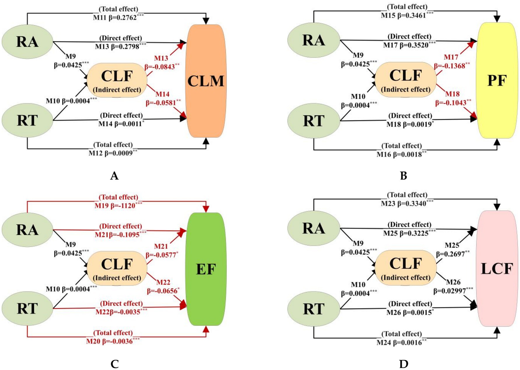
Figure 6. Results of the driving mechanism of road network on CLM. RA, RT denote road network accessibility and transfer capacity, respectively; CLF denotes cultivated land fragmentation; CLM, PF, EF, LCF denote the overall level of cultivated land multifunctionality, production function, ecological function, and landscape cultural function, respectively; black solid arrows denote significant positive impacts, and red solid arrows denote significant negative impacts.
Regarding overall CLM levels (Figure 6A), M9 and M11 demonstrate that road network accessibility exerts significant positive effects on both CLM and CLF. When both variables were incorporated into M13, regression results showed they simultaneously influenced CLM significantly, indicating that road network accessibility indirectly affects overall CLM through CLF. Crucially, the indirect effect of road network accessibility on CLM (−0.0036 = 0.0425 × −0.0843) opposes its direct effect (0.2798) in sign. This reveals that CLF exerts a masking effect (−0.0036), accounting for 1.30% of the total effect (0.2762). Specifically, CLF weakens the enhancing impact of road network accessibility on overall CLM. Similarly, CLF demonstrates a masking effect on the positive influence of road network transfer capacity on CLM, constituting 2.58% (=0.0004 × 0.0581/0.0009 × 100%) of the total effect.

Figure 7. Results of the heterogeneity analysis of the main functional zones of the road network on the CLM. RA, RT denote road network accessibility and transfer capacity, respectively; CLF denotes cultivated land fragmentation; CLM, PF, EF, LCF denote the overall level of cultivated land multifunctionality, production function, ecological function, and landscape cultural function, respectively; black solid arrows denote significant positive impacts, red solid arrows denote significant negative impacts and dotted line indicates that the result is not significant.
Regarding individual cultivated land functions, our prior findings confirm that road network accessibility and transfer capacity significantly affect all three cultivated land functions and CLF, indicating their capacity to indirectly influence production function, ecological function, and landscape cultural function through CLF. Crucially, CLF’s mediating effects diverge substantially across functional types. For the production function (Figure 6B), M17 and M18 reveal that the indirect effects of road network accessibility and transfer capacity (−0.0058 = 0.0425 × −0.1368, −0.00004 = 0.0004 × −0.1043, respectively) oppose their direct effects (0.3520 and 0.0019) in sign. This demonstrates that CLF exerts significant masking effects on both road network metrics’ influence on the production function. These masking effects constitute 1.68% and 2.32% of the total effects (0.3461 and 0.0018), respectively, thereby attenuating the enhancing impacts of accessibility and transfer capacity on production function. For the ecological function (Figure 6C), M21 and M22 indicate that the indirect effects of road network accessibility and transfer capacity (−0.0021 = 0.0425 × −0.0577, −0.00003 = 0.0004 × −0.0656, respectively) align in sign with their direct effects (−0.1095 and −0.0035). This demonstrates that CLF exerts a significant mediating role in both road network metrics’ influence on ecological function. These mediating effects constitute 2.19% and 0.73% of the total effects (−0.1120 and −0.0036), respectively. Thus, both road network accessibility and transfer capacity suppress ecological function by intensifying CLF. Regarding the landscape cultural function (Figure 6D), M82 and M83 demonstrate that the indirect effects of road network accessibility and transfer capacity (0.0114 = 0.0425 × 0.2697, 0.0001 = 0.0004 × 0.2997, respectively) align in sign with their direct effects (0.3225 and 0.0015). This indicates CLF exerts a significant mediating role in both road network metrics’ influence on landscape cultural function. These mediating effects constitute 3.43% and 7.49% of the total effects (0.3340 and 0.0016), respectively. Thus, enhanced road network accessibility and transfer capacity improve landscape cultural function by intensifying CLF.
4.3 Heterogeneity analysis: based on the major function-oriented zones
This study employed grouped regression methods to construct models M27-M30 (see Supplementary Table A4), examining the heterogeneity of road network impacts on CLM across MFOZs. Regression coefficients for core variables are presented in Figure 7.
In the Major Agricultural Production Zone (Figure 7A), road network accessibility significantly influenced overall CLM, production function, ecological function, and landscape cultural function, with effect directions consistent with the study area’s aggregate results. Conversely, road network transfer capacity showed limited statistical significance, significantly impacting only overall CLM and ecological function. Within the Key Development Zone (Figure 7B), both road network accessibility and transfer capacity exerted significant impacts on overall CLM and all three constituent functions, exhibiting directional consistency with aggregate findings. For the Key Ecological Function Zone (Figure 7C), road network accessibility significantly affected overall CLM and ecological function, while its impacts on production function and landscape cultural function failed to reach statistical significance. Road network transfer capacity showed only a significant negative effect on ecological function, with other effects being statistically insignificant.
Collectively, this study reveals significant heterogeneity in road network impacts on CLM across MFOZs. The Key Development Zone exhibits heightened CLM sensitivity to both road network accessibility and transfer capacity, whereas the Major Agricultural Production Zone demonstrates CLM responsiveness primarily driven by accessibility. Conversely, the Key Ecological Function Zone demonstrates limited overall CLM sensitivity to road networks, though its ecological function remains vulnerable to adverse impacts from both accessibility and transfer capacity.
This spatial heterogeneity originates from differentiated cultivated land use patterns and agricultural product characteristics: In the highly urbanized Key Development Zone, cultivated land predominantly supports modern urban agriculture (e.g., vegetables, fruits, flowers) characterized by high-input requirements, perishability, and limited storability (Zhou et al., 2025), necessitating robust accessibility and transfer capacity for rapid product evacuation and market-distribution linkages. This explains the zone’s dual sensitivity to both road metrics. Within the Major Agricultural Production Zone, extensive permanent basic farmland facilitates large-scale mechanized cultivation of storable field crops (e.g., wheat, rapeseed, rice), primarily reliant on accessibility for mechanized farming and bulk transportation with minimal transfer capacity needs, accounting for the dominance of accessibility effects. The Key Ecological Function Zone, dominated by mountainous terrain with poorer-quality cultivated land under stronger biophysical constraints, exhibits attenuated overall CLM responsiveness. However, this zone’s combination of high ecological value, ecosystem fragility, and low resource-environmental carrying capacity amplifies the negative impacts of road networks—particularly accessibility enhancements—on ecological function, rendering it uniquely vulnerable to infrastructure-mediated ecological degradation.
As evidenced, road network accessibility exerts a more pronounced and widespread impact on CLM than road network transit capacity across different types of MFOZs. Given that the influence of transit capacity remains relatively limited in both Major Agricultural Production Zone and Key Ecological Function Zone, its average effect becomes diluted in the full-sample regression, resulting in a weaker observed overall impact. This pattern not only offers a compelling explanation for the more dominant role of road accessibility in the baseline regression results, but also reinforces the robustness of our research findings by demonstrating consistent systematic variation in the effects of road networks on CLM among different functional zones.
5 Discussion and conclusion
5.1 Discussion
5.1.1 Comprehensively understand the impact of road networks on CLM
Enhancing CLM management has emerged as a global consensus to address compounding challenges of intensifying food security pressures, frequent extreme climate events, and ecological degradation (Jiang et al., 2020; Masuda et al., 2022). As CLM emerges from systemic interactions within cultivated land systems, current research prioritizes natural-socioeconomic drivers—including temperature, precipitation, soil types, fertilizer use, and urbanization—while overlooking the role of road networks as circulatory conduits for these elements. Leveraging complex network theory, this study quantifies road network accessibility and transfer capacity through closeness and betweenness centrality metrics, systematically revealing their mechanistic impacts on CLM. This study not only provides theoretical underpinnings for optimizing territorial spatial configurations and sustainable cultivated land management, but ultimately offers actionable strategies for refining road network planning to advance CLM conservation and utilization.
This study initially explores the direct impacts of road networks on CLM. Results demonstrate that road network accessibility and transfer capacity have a significantly positive effect on overall CLM levels, specifically enhancing production function and landscape cultural function while suppressing ecological function. This outcome underscores the urgency of strengthening ecological conservation during road network expansion, aligning with Laurance et al. (2014) concern regarding ecological externalities of infrastructure development and corroborating findings by Fan et al. (2023). Further analysis reveals that accessibility constitutes a more critical determinant than transfer capacity across all functional dimensions. Consequently, optimization strategies should prioritize maximizing accessibility’s contributions to production and landscape-cultural functions while minimizing its ecological footprint. Implementing road network planning strategies that simultaneously enhance accessibility and ecological compatibility constitutes the central pathway for optimization. Practically, three-dimensional infrastructure—including bridges, culverts, and tunnels—enables avoidance of rigid protection boundaries and effective connection shortening, serving as dual solutions for enhancing accessibility while reducing ecological footprints (Zhang et al., 2024). Therefore, actively advancing such structural solutions to increase bridge-tunnel ratios represents an actionable strategy to mitigate road networks’ adverse ecological impacts and promote sustainable CLM development.
Our study further elucidates the mediating mechanism whereby road networks indirectly influence CLM through CLF, providing a theoretical foundation for synergistic management of transportation infrastructure and cultivated land resources to enhance CLM. These findings resonate with scholarly emphasis on landscape-scale coordination for multifunctionality enhancement (Guo et al., 2023). We demonstrate that road network expansion intensifies cultivated land fragmentation, which subsequently diminishes the positive impacts of road infrastructure on overall CLM. Mitigating road-induced fragmentation is therefore crucial for CLM enhancement. This necessitates strengthened interdepartmental collaboration between transportation and cultivated land conservation authorities to establish coordinated mechanisms integrating road network planning with farmland protection policies. At the macro-policy level, leveraging China’s “multi-plan integration” territorial spatial governance system should reinforce rigid spatial constraints for permanent basic cultivated land, rigorously evaluate cultivated land occupation in road projects, and prioritize bypassing high-quality contiguous cultivated land to minimize segmentation and appropriation. In micro-practice, implementing land-saving road network layouts—including advancing three-dimensional infrastructure to increase bridge-tunnel ratios, reducing slope lengths and roadbed footprints, and promoting cultivated land contiguity—constitutes essential technical pathways for fragmentation reduction.
5.1.2 Optimizing road network planning through differential strategies aligned with Major Functional Zone positioning to enhance CLM governance
Significant heterogeneity exists in road network impacts on CLM across MFOZs, urgently requiring the formulation of differentiated spatial planning strategies aligned with zonal resource characteristics and development demands to strengthen CLM management.
The Major Agricultural Production Zone possesses superior agricultural resource endowments, with its core objective centered on enhancing agricultural productivity and safeguarding food supply. Research demonstrates that CLM in this zone—particularly the PF—significantly benefits from improved road network accessibility. Consequently, regional priorities should focus on optimizing hierarchical road infrastructure, strengthening connectivity, and enhancing accessibility to reinforce agricultural production capacity. Notably, such accessibility improvements simultaneously exert negative ecological impacts on cultivated land, potentially threatening sustainable agricultural output. To mitigate these infrastructure-mediated ecological risks while ensuring sustainable production, implementing shelterbelts along field margins offers a dual-purpose solution: serving as ecological barriers against pollutants (e.g., dust, heavy metals) while improving farmland microclimates and providing essential ecosystem services to support stable crop yields (Robinson et al., 2022).
The Key Ecological Function Zones exhibit high ecological endowment and critical functionality, yet face inherent ecosystem fragility and constrained resource-environmental carrying capacities, with their core objective centered on enhancing ecological service provision. Empirical findings confirm that road network accessibility and transfer capacity in these zones exert exclusively negative impacts on cultivated land ecological functionality. Consequently, strategic restraint in road network expansion is imperative, leveraging the pristine ecological matrix to integrate ecological corridors into transportation planning frameworks—effectively mitigating infrastructure-induced ecological externalities (Qiu et al., 2025).
The Key Development Zone exhibits robust resource carrying capacity, significant development potential, and high urbanization levels, with its core objectives centered on population agglomeration and socioeconomic growth. Empirical findings confirm that enhanced road accessibility and transfer capacity significantly improve overall CLM, along with production and landscape cultural function, albeit at the expense of ecological functionality. Consequently, this zone should proactively advance road network optimization through intersection refinement and connectivity reinforcement to elevate accessibility and nodal functionality, thereby enhancing CLM—particularly landscape-cultural manifestation—to support regional development goals. Complementary implementation of ornamental greenbelts along field margins can simultaneously elevate aesthetic values while functioning as ecological buffers to mitigate environmental risks.
5.2 Limitations and future research
This study acknowledges several limitations. First, our assessment of road network characteristics considered only hardened roads within Hubei’s administrative boundaries, excluding non-hardened roads and cross-jurisdictional spatial linkages, potentially underestimating accessibility and transfer capacity near administrative edges. Future research could incorporate remote sensing to identify non-hardened roads and establish cross-boundary buffer zones centered on Hubei, analyzing provincial networks within open systems to enhance boundary-zone accuracy. Second, while CLM encompasses both aggregate-level (weighted sum of functions within a region) and structural-level (proportional relationships/configuration among functions reflecting diversity and evenness) dimensions, this study focused exclusively on aggregate CLM. Future research should consequently investigate the evolutionary patterns of CLM under both aggregate and structural frameworks alongside their responses to road network characteristics, thereby establishing a more comprehensive scientific foundation for CLM governance. Third, while this study quantified physical landscape fragmentation of cultivated land using the SPLIT index (capturing parcel-scale attributes of size, shape, and spatial distribution), the conceptual scope of fragmentation extends to encompass land-use fragmentation (diverse agricultural practices, crop varieties, or harvest frequencies within parcels) and tenure fragmentation (multiple ownership structures per parcel) (Ntihinyurwa et al., 2019). These dimensions influence functional manifestation by constraining farmers’ scaled operational decisions and suppressing technological adoption incentives through behavioral pathways. Consequently, future research should employ multi-metric approaches to assess these distinct fragmentation dimensions, rigorously analyze their transmission mechanisms, and generate actionable scientific guidance for refined landscape pattern management.
5.3 Conclusion
Clarifying the impacts and driving mechanisms of road networks on CLM constitutes a critical foundation for optimizing road infrastructure planning, enhancing CLM performance, refining territorial spatial configurations, and advancing sustainable cultivated land management. Leveraging data from China’s Hubei Province for 2013 and 2022, this study examines the effects of road network accessibility and transfer capacity on CLM and their underlying mechanisms, building upon comprehensive analyses of spatio-temporal evolution in both road network characteristics and CLM patterns. The findings reveal:
1. Enhanced road network accessibility and transfer capacity significantly elevate the overall level of CLM, concurrently boosting production function and landscape cultural function while suppressing ecological function, necessitating prioritized ecological conservation measures during road infrastructure expansion.
2. CLF exerts a masking effect on road network impacts on CLM, attenuating the positive influence on overall CLM while negatively affecting production function and ecological function, yet positively influencing landscape cultural function. Establishing collaborative mechanisms between transportation and cultivated land conservation authorities to coordinate road planning with cultivated land protection policies—reducing land segmentation, minimizing occupation, and advancing farmland consolidation—thus constitutes a critical pathway for mitigating fragmentation-induced CLM trade-offs and advancing science-based land management.
3. Significant MFOZs heterogeneity characterizes the impacts of road network accessibility and transfer capacity on CLM. The Key Development Zone demonstrates heightened CLM sensitivity to both road network accessibility and transfer capacity, whereas CLM in the Major Agricultural Production Zone remains predominantly driven by accessibility. Conversely, the Key Ecological Function Zone exhibits attenuated overall responsiveness to road networks, though its ecological function shows pronounced vulnerability to negative accessibility and transfer capacity effects. This spatial divergence necessitates differentiated road network optimization strategies aligned with zonal resource endowments and developmental imperatives to strengthen CLM governance.
Data availability statement
The datasets presented in this article are not readily available because the original contributions presented in the study are included in the article/supplementary material, further inquiries can be directed to the authors. Requests to access the datasets should be directed to Fan Liu, bGl1ZmFuQHdlYm1haWwuaHphdS5lZHUuY24=.
Author contributions
FL: Conceptualization, Data curation, Formal analysis, Investigation, Methodology, Project administration, Resources, Software, Supervision, Validation, Visualization, Writing – original draft, Writing – review & editing. WH: Funding acquisition, Project administration, Resources, Supervision, Writing – original draft, Writing – review & editing. MM: Writing – review & editing. TL: Supervision, Validation, Writing – review & editing. SL: Supervision, Validation, Writing – review & editing. QR: Supervision, Validation, Writing – review & editing.
Funding
The author(s) declare that financial support was received for the research and/or publication of this article. This paper was funded by the National Natural Science Foundation of China (grant no. 71673105) and the Ministry of Education of Humanities and Social Science project (grant no. 22TJA630029).
Conflict of interest
The authors declare that the research was conducted in the absence of any commercial or financial relationships that could be construed as a potential conflict of interest.
The handling editor LW declared a past co-authorship with the author WH.
Generative AI statement
The authors declare that no Gen AI was used in the creation of this manuscript.
Any alternative text (alt text) provided alongside figures in this article has been generated by Frontiers with the support of artificial intelligence and reasonable efforts have been made to ensure accuracy, including review by the authors wherever possible. If you identify any issues, please contact us.
Publisher’s note
All claims expressed in this article are solely those of the authors and do not necessarily represent those of their affiliated organizations, or those of the publisher, the editors and the reviewers. Any product that may be evaluated in this article, or claim that may be made by its manufacturer, is not guaranteed or endorsed by the publisher.
Supplementary material
The Supplementary material for this article can be found online at: https://www.frontiersin.org/articles/10.3389/fsufs.2025.1686176/full#supplementary-material
References
Asadi, A., Barati, A. A., Kalantari, K., and Odeh, I. (2016). Study of relationship between roads network development and agricultural land conversion in Iran NorthWest. Int. J. Environ. Res. 10, 51–58. Avaialble at: https://webofscience.clarivate.cn/wos/alldb/full-record/WOS:000379755200006, https://ijer.ut.ac.ir/article_56887_ae016d23a5633eafceb8b4513836232f.pdf
Bennett, V. J. (2017). Effects of road density and pattern on the conservation of species and biodiversity. Curr. Landsc. Ecol. Rep. 2, 1–11. doi: 10.1007/s40823-017-0020-6
Cai, E., Zhang, S., Chen, W., Zhai, T., and Li, L. (2024). Spatial–temporal evolution characteristics of cultivated land structure transition: a case study of Hubei Province, Central China. Environ. Dev. Sustain., 1–17. doi: 10.1007/s10668-024-05298-7
Chai, J., Wang, Z. Q., Yang, J., and Zhang, L. G. (2019). Analysis for spatial-temporal changes of grain production and farmland resource: evidence from Hubei Province, Central China. J. Clean. Prod. 207, 474–482. doi: 10.1016/j.jclepro.2018.10.008
Chakrabarti, S., Kushari, T., and Mazumder, T. (2022). Does transportation network centrality determine housing price? J. Transp. Geogr. 103:103397. doi: 10.1016/j.jtrangeo.2022.103397
Fan, Y. T., Jin, X. B., Gan, L., Yang, Q. K., Wang, L. Z., Lyu, L., et al. (2023). Exploring an integrated framework for "dynamic-mechanism-clustering" of multiple cultivated land functions in the Yangtze River Delta region. Appl. Geogr. 159:103061. doi: 10.1016/j.apgeog.2023.103061
Fathi, M., and Masnavi, M. R. (2014). Assessing environmental aesthetics of roadside vegetation and scenic beauty of highway landscape: preferences and perception of motorists. Int. J. Environ. Res. 8, 941–952. Avaialble at: https://webofscience.clarivate.cn/wos/alldb/full-record/WOS:000344126300008, https://ijer.ut.ac.ir/article_786_fd89a0f2645a383d215f6f0337889916.pdf
Fieden, L. (2019). Changes in land use in the communes crossed by the A4 motorway in Poland. Land Use Policy 85, 397–406. doi: 10.1016/j.landusepol.2019.04.025
Gong, H., Zhao, Z., Chang, L., Li, G., Li, Y., and Li, Y. (2022). Spatiotemporal patterns in and key influences on cultivated-land multi-functionality in Northeast China’s black-soil region. Land 11:1101. doi: 10.3390/land11071101
Guo, Y. J., Ren, Z. B., Dong, Y. L., Zhang, P., Wang, C. C., Ma, Z. J., et al. (2023). Multifunctionality can be promoted by increasing agriculture-dominated heterogeneous landscapes in an agro-forestry interlacing zone in Northeast China. Landsc. Urban Plan. 238:104832. doi: 10.1016/j.landurbplan.2023.104832
Hu, Y. G., Li, X., Song, Y., and Huang, C. (2023). Data-driven evaluation framework for the effectiveness of rural vitalization in China: an empirical case study of Hubei Province. Environ. Sci. Pollut. Res. 30, 20235–20254. doi: 10.1007/s11356-022-23393-y
Jiang, G., Wang, M., Qu, Y., Zhou, D., and Ma, W. (2020). Towards cultivated land multifunction assessment in China: applying the “influencing factors-functions-products-demands” integrated framework. Land Use Policy 99:104982. doi: 10.1016/j.landusepol.2020.104982
Kim, H. S., Kim, K.-R., Kim, W.-I., Owens, G., and Kim, K.-H. (2017). Influence of road proximity on the concentrations of heavy metals in Korean urban agricultural soils and crops. Arch. Environ. Contam. Toxicol. 72, 260–268. doi: 10.1007/s00244-016-0344-y
Latruffe, L., and Piet, L. (2014). Does land fragmentation affect farm performance? A case study from Brittany, France. Agric. Syst. 129, 68–80. doi: 10.1016/j.agsy.2014.05.005
Laurance, W. F., Clements, G. R., Sloan, S., O’Connell, C. S., Mueller, N. D., Goosem, M., et al. (2014). A global strategy for road building. Nature 513, 229–232. doi: 10.1038/nature13717
Li, S., and Cai, Y. (2022). Effect analysis of road structure on multidimensional fragmentation of cultivated land: a case study in the international metropolis of Shanghai City. Chin. J. Eco-Agric. 30, 1203–1214. doi: 10.12357/cjea.20210707
Liu, Y., Wan, C., Xu, G., Chen, L., and Yang, C. (2023). Exploring the relationship and influencing factors of cultivated land multifunction in China from the perspective of trade-off/synergy. Ecol. Indic. 149:110171. doi: 10.1016/j.ecolind.2023.110171
Liu, Y. L., Wei, X. J., Jiao, L. M., and Wang, H. M. (2016). Relationships between street centrality and land use intensity in Wuhan, China. J. Urban Plann. Dev. 142:274. doi: 10.1061/(ASCE)UP.1943-5444.0000274
Looga, J., Jürgenson, E., Sikk, K., Matveev, E., and Maasikamäe, S. (2018). Land fragmentation and other determinants of agricultural farm productivity: the case of Estonia. Land Use Policy 79, 285–292. doi: 10.1016/j.landusepol.2018.08.021
Lu, X., Hou, J., Tang, Y., Wang, T., Li, T., and Zhang, X. (2022b). Evaluating the impact of the highway infrastructure construction and the threshold effect on cultivated land use efficiency: evidence from Chinese provincial panel data. Land 11:1044. doi: 10.3390/land11071044
Lu, H. Y., Zhao, P. J., Hu, H. Y., Zeng, L. G., Wu, K. S., and Lv, D. (2022a). Transport infrastructure and urban-rural income disparity: a municipal-level analysis in China. J. Transp. Geogr. 99:3292. doi: 10.1016/j.jtrangeo.2022.103292
Masuda, Y., Oka, T., Yoshinari, E., Nishida, T., and Ikeda, T. (2022). “Analysis of the description of the multifunctionality of farmland in the administrative plans of local municipalities,” in Green Infrastructure and Climate Change Adaptation, ed. Futoshi Nakamura (Singapore: Springer Nature Singapore Press), 476–490.
Microsoft, B. (2022). Available online at: https://gee-community-catalog.org/projects/msroads/ (Accessed July 1, 2024).
Moon, W. (2010). Multifunctional agriculture, protectionism, and prospect of trade liberalization. J Rural Dev 33, 29–61. doi: 10.22004/ag.econ.174478
National Bureau of Statistics. (2023). Available online at: https://www.stats.gov.cn/sj/ndsj/ (Accessed July 1, 2024).
Ntihinyurwa, P. D., de Vries, W. T., Chigbu, U. E., and Dukwiyimpuhwe, P. A. (2019). The positive impacts of farm land fragmentation in Rwanda. Land Use Policy 81, 565–581. doi: 10.1016/j.landusepol.2018.11.005
Pu, J., Shen, A. R., Liu, C. X., and Wen, B. (2024). Impacts of ecological land fragmentation on habitat quality in the Taihu Lake basin in Jiangsu Province. China. Ecological Indicators 158:1611. doi: 10.1016/j.ecolind.2024.111611
Qiu, W., Jia, D., Guo, R., Zhang, L., Wang, Z., and Hu, X. (2025). Unequal impact of road expansion on regional ecological quality. Land 14:523. doi: 10.3390/land14030523
Qiu, L. F., Zhu, J. X., Pan, Y., Wu, S. H., Dang, Y. X., Xu, B. G., et al. (2020). The positive impacts of landscape fragmentation on the diversification of agricultural production in Zhejiang Province. China. J Cleaner Production 251:9722. doi: 10.1016/j.jclepro.2019.119722
Robinson, S. V., Nguyen, L. H., and Galpern, P. (2022). Livin'on the edge: precision yield data shows evidence of ecosystem services from field boundaries. Agric. Ecosyst. Environ. 333:107956. doi: 10.1016/j.agee.2022.107956
Shi, W., and Liu, D. (2023). Does urbanization reduce the multi-functional value of cultivated land? Evidence from China. Front. Environ. Sci. 11:1102300. doi: 10.3389/fenvs.2023.1102300
Simelton, E., Ostwald, M., and Osiru, M. (2019). "Multifunctional land-use practices in Africa: What else do we need to do?," in Multifunctional Land Uses in Africa, ed. Simelton (Oxford: Taylor & Francis Press), 134–154.
Tang, Y. F., Lu, X. H., Wang, M. C., Jiang, B., Chen, D. L., and Ge, K. (2022). Assessing the threshold effects of road infrastructure construction on farmland use transition: an empirical study in China. Environ. Sci. Pollut. Res. 29, 47323–47336. doi: 10.1007/s11356-022-19276-x
Tong, T. T., Yu, T. H. E., Cho, S. H., Jensen, K., and Ugarte, D. D. (2013). Evaluating the spatial spillover effects of transportation infrastructure on agricultural output across the United States. J. Transp. Geogr. 30, 47–55. doi: 10.1016/j.jtrangeo.2013.03.001
Ullah, S., Ai, C., Huang, S., Song, D., Abbas, T., Zhang, J., et al. (2020). Substituting ecological intensification of agriculture for conventional agricultural practices increased yield and decreased nitrogen losses in North China. Appl. Soil Ecol. 147:103395. doi: 10.1016/j.apsoil.2019.103395
Van Huylenbroeck, G., Vandermeulen, V., Mettepenningen, E., and Verspecht, A. (2007). Multifunctionality of agriculture: a review of definitions, evidence and instruments. Living Rev. Landscape Res. 1, 1–43. Available at: http://lrlr.landscapeonline.de/lrlr-2007-3
Vos, W., and Meekes, H. (1999). Trends in European cultural landscape development: perspectives for a sustainable future. Landsc. Urban Plan. 46, 3–14. doi: 10.1016/S0169-2046(99)00043-2
Wang, Y. H., Li, X. B., Lu, D., and Yan, J. Z. (2020). Evaluating the impact of land fragmentation on the cost of agricultural operation in the southwest mountainous areas of China. Land Use Policy 99:105099. doi: 10.1016/j.landusepol.2020.105099
Wen, G., Zhang, Z., Tian, Y., Fang, L., Wang, Z., and Ding, X. (2024). Temporal and spatial characteristics of cultivated land non-point source pollution in the main grain-producing areas of the middle and lower Yangtze region. J. Agro-Environ. Sci. 43, 133–142. doi: 10.11654/jaes.2023-0168
Wilson, G. A. (2009). The spatiality of multifunctional agriculture: a human geography perspective. Geoforum 40, 269–280. doi: 10.1016/j.geoforum.2008.12.007
Wu, C. F., Lin, Y. P., Chiang, L. C., and Huang, T. (2014). Assessing highway's impacts on landscape patterns and ecosystem services: a case study in Puli township, Taiwan. Landsc. Urban Plan. 128, 60–71. doi: 10.1016/j.landurbplan.2014.04.020
Xiao, R., Liu, Y., Huang, X., Shi, R., Yu, W., and Zhang, T. (2018). Exploring the driving forces of farmland loss under rapid urbanization using binary logistic regression and spatial regression: a case study of Shanghai and Hangzhou Bay. Ecol. Indic. 95, 455–467. doi: 10.1016/j.ecolind.2018.07.057
Xin, J., Peng, Y., Peng, N., Yang, L., Huang, J., Yuan, J., et al. (2024). Both class-and landscape-level patterns influence crop yield. Eur. J. Agron. 153:127057. doi: 10.1016/j.eja.2023.127057
Yang, J., and Huang, X. (2021). The 30 m annual land cover dataset and its dynamics in China from 1990 to 2019. Earth Syst. Sci. Data 13, 3907–3925. doi: 10.5194/essd-13-3907-2021
Yu, M., Yang, Y., Chen, F., Zhu, F., Qu, J., and Zhang, S. (2019). Response of agricultural multifunctionality to farmland loss under rapidly urbanizing processes in Yangtze River Delta, China. Sci. Total Environ. 666, 1–11. doi: 10.1016/j.scitotenv.2019.02.226
Zenka, J., Slach, O., Krticka, L., and Zufan, P. (2016). Determinants of microregional agricultural labour productivity - evidence from Czechia. Appl. Geogr. 71, 83–94. doi: 10.1016/j.apgeog.2016.04.004
Zhang, S. Y., Hu, W. Y., Li, M. R., Guo, Z. X., Wang, L. Y., and Wu, L. H. (2021). Multiscale research on spatial supply-demand mismatches and synergic strategies of multifunctional cultivated land. J. Environ. Manag. 299:113605. doi: 10.1016/j.jenvman.2021.113605
Zhang, H., Xu, X., Zhang, C., Fu, Z.-P., and Yang, H.-Z. (2024). Novel method for ecosystem services assessment and analysis of road-effect zones. Transp. Res. Part D Transp. Environ. 127:104057. doi: 10.1016/j.trd.2024.104057
Zhao, R., Li, J., Wu, K., and Kang, L. (2021). Cultivated land use zoning based on soil function evaluation from the perspective of black soil protection. Land 10:605. doi: 10.3390/land10060605
Zhou, X. P., Xiao, L. K., Lu, X., and Sun, D. Q. (2020). Impact of road transportation development on habitat quality in economically developed areas: a case study of Jiangsu Province, China. Growth Chang. 51, 852–871. doi: 10.1111/grow.12374
Zhou, Z. X., Zhao, F. Z., and Song, B. J. (2025). Evaluation and changes in the comprehensive ecological effects of agriculture in urbanizing areas: a case study of the Xi'an metropolitan zone, China. Ecological Indicators 170:3078. doi: 10.1016/j.ecolind.2025.113078
Keywords: road networks, cultivated land multifunctionality, cultivated land fragmentation, major function-oriented zone, Hubei Province
Citation: Liu F, Hu W, Min M, Liu T, Li S and Rong Q (2025) How does road networks impact cultivated land multifunctionality? The role of land fragmentation: evidence from Hubei Province, China. Front. Sustain. Food Syst. 9:1686176. doi: 10.3389/fsufs.2025.1686176
Edited by:
Liye Wang, Shandong University of Finance and Economics, ChinaReviewed by:
Yanyan Li, Henan Normal University, ChinaCheng Jia, Shandong Agricultural University, China
Copyright © 2025 Liu, Hu, Min, Liu, Li and Rong. This is an open-access article distributed under the terms of the Creative Commons Attribution License (CC BY). The use, distribution or reproduction in other forums is permitted, provided the original author(s) and the copyright owner(s) are credited and that the original publication in this journal is cited, in accordance with accepted academic practice. No use, distribution or reproduction is permitted which does not comply with these terms.
*Correspondence: Weiyan Hu, aHV3ZWl5YW5AbWFpbC5oemF1LmVkdS5jbg==