 Volodymyr Iemelianov1
 Olena Ivanik1,2*
 Tamara Kukovska1
 Natalia Fedoronchuk1,3
 Ihor Shuraiev1
 Eduard Petrushenko2
 Kateryna Hadiatska2
- 1Center for Problems of Marine Geology, Geoecology and Sedimentary Ore Formation of National Academy of Science of Ukraine, Kyiv, Ukraine
- 2Institute of Geology, Taras Shevchenko National University of Kyiv, Kyiv, Ukraine
- 3Faculty of Geology and Geography, Odesa I.I. Mechnikov National University, Odesa, Ukraine
Gas hydrates are prevalent in marine sediments in regions characterized by certain bathymetry, geomorphology, lithology, and physics (i.e., low temperature and high pressure conditions). The gas hydrates in the Black Sea serve as not only a promising source of energy and chemical resources but also as indicators of active fault zones and sites where the latest geological and geochemical processes are unfolding. The main goal of the present studies is to examine the main factors influencing gas hydrate formation, to understand their combinations and priority, and finally to demonstrate the potential of the integrated technique for gas hydrate abundance at the regional scale. This study employs a structured workflow consisting of database compilation, geological process analysis, identification of key gas hydrate indicators, GIS-based modeling, and hazard assessment. A comprehensive GIS project for the Black Sea was developed to integrate diverse datasets, including geological, geomorphological, and oceanographic information. Spatial analysis and modeling techniques, including weighted overlay methods, were applied to assess the influence of geological and environmental factors on gas hydrate formation. Spatial analyses confirm that gas hydrates are primarily confined to continental slope, where active geological processes such as landslides and methane seepage are present. Key controlling factors include seabed geomorphology, lithology, tectonic structures, and fluid migration pathways. Structural and tectonic analysis revealed a strong correlation between gas hydrate distribution and fault systems. Additionally, mud volcanoes, paleo-river canyons, and fluid migration structures play a crucial role in hydrate formation. A susceptibility map of the Black Sea gas hydrates was created using weighted ranking of geological, geomorphological, and oceanographic parameters. The susceptibility inference process has revealed substantial knowledge gaps, as the uncertainty analysis identifies large seafloor regions with insufficient data or extremely low data density. The developed model could be applied for a better understanding of the vulnerability of areas, and to apply the methods of local predictions of gas hydrates. This model highlights potential hydrate-bearing zones and serves as a predictive tool for future exploration and hazard mitigation. This study also provides valuable insights into marine geohazard preparedness, risk reduction, and sustainable practices in the Black Sea.
1 Introduction
Gas hydrates are increasingly recognized as key geological features within continental margin systems, where their formation and stability are governed by complex interactions between sedimentation, tectonics, fluid migration, and methane availability. These hydrates hold significant importance for potential energy sources and have garnered attention from both governments and industries due to their vast resource potential (Kuustraa and Hammershaimb, 1983). Recognized as one of the most promising alternative energy sources for commercial development (Makogon et al., 2007), it has led over 30 countries worldwide to establish national strategies for its development and actively pursue research on hydrate exploration and extraction (Yushan, 2012). Additionally, international collaborations and investments in gas hydrate research have grown significantly over the last decade, reflecting the increasing urgency to develop alternative energy solutions. The primary methods for extracting natural gas hydrate include depressurization, heating, inhibitor, CO2 replacement, and solid exploitation techniques (Wang et al., 2022). Some authors demonstrate the potential effectiveness of method of methane production from gas hydrates using thermal energy from mud volcano emissions (Klymenko et al., 2022). An algorithm has been proposed to calculate the distance that the flow of emissions from mud volcanoes can travel at a temperature sufficient to disrupt the thermodynamic equilibrium of seabed hydrates and release methane. The use of this alternative method for methane production can increase the amount of gas extracted from underwater sources by 7%–10% without the need for additional thermal energy sources. The reservoir of hydrates can exert a considerable influence on the environment and climate due to methane being a potent greenhouse gas (Collett and Lee, 2000; Collett et al., 2009; Ruppel, 2011). Reducing methane emissions is essential to mitigating the effects of climate change, as even small reductions can have a substantial impact on the planet’s warming trajectory. Further research into methane capture and utilization technologies is being conducted to minimize potential environmental hazards associated with gas hydrate exploitation.
Gas hydrates in the Black Sea are of immense scientific significance due to their energy potential, their impact on seafloor stability, and their role in climate dynamics. Ongoing research in this region is essential to advancing knowledge on hydrate behavior, mitigating associated risks, and exploring sustainable utilization strategies. The gas hydrates in the Black Sea serve also as indicators of active fault zones and sites where the latest geological and geochemical processes are unfolding. The presence of gas hydrates can pose a significant hazard by altering the stability of seafloor sediments, leading to collapses and landslides. Sampling of natural gas hydrates in the Black Sea was first reported in 1974 (Efremova and Zhizhchenko, 1974). Since then, numerous research expeditions and projects have been conducted to investigate the occurrence, distribution and extraction of methane gas and gas hydrates along the Black Sea’s continental margins (Shnyukov et al., 1993; Shnyukov and Kobolev, 2017; Vassilev and Dimitrov, 2002; Starostenko et al., 2010; Haeckel et al., 2017; Klymenko et al., 2022; Bazaluk et al., 2021). Over the last years, research on gas hydrates in the Black Sea resulted in the observing of numerous active gas emission sites, mud volcanoes, gas seeps and indicators of gas hydrate distribution (Vassilev and Dimitrov, 2002; Naudts et al., 2009; Starostenko et al., 2010; Körber et al., 2014). For analytical and laboratory analysis of gas volumes obtained during the dissociation of deposits with heterogeneous structures an integrated methodological approach was developed (Bazaluk et al., 2021). The dissociation zone parameters for gas hydrate deposits with varying amounts of rock intercalation have been determined, and the potentially recoverable gas volumes have been estimated. The findings from this research on the dissociation process of gas hydrate deposits could be applied in the development of new technologies for gas recovery in the Black Sea region.
Numerous studies have been conducted to investigate the mechanisms of gas hydrate formation and the corresponding controlling factors in various parts of the Black Sea basin. For instance, in the western part of the basin research provided by Burwicz-Galerne et al. (2024) identified unique mechanisms responsible for gas hydrate reservoir formation: gas hydrate recycling zones, chimney-like structures, and deposits linked to paleo-deep sea fans. New computational models have been developed to simulate gas hydrate dynamics. By simulating and analyzing key controlling factors, including methane migration pathways and regional geomorphology, authors elucidated the processes driving the hydrate formation. The distribution of gas hydrates is highly sensitive to external factors that influence the spatial extent of the gas hydrate stability zone (GHSZ) (Vassilev A. and Dimitrov L., 2002; Burwicz-Galerne et al., 2024). These factors include variations in geomorphology zones, water depth, bottom-water temperature, sedimentation rates, tectonic and erosion processes. Recent studies also suggest that seasonal temperature fluctuations may have a more significant impact on hydrate stability than previously thought. Geological research have tried to understand the geological, morphological, structural, sedimentation, and organic features of gas hydrate formations (León et al., 2021; Shnyukov and Kobolev, 2017; Gevorkyan et al., 1991; Gupta et al., 2023; Schmidt et al., 2022; Vassilev and Dimitrov, 2002; Biastoch et al., 2011; Kretschmer et al., 2015; Wallmann et al., 2018; Sanjeev and Naresh, 2016; Mienert et al., 2022). Recent studies also have focused on high-resolution resistivity imaging of hydrate-bearing structures, helping to refine predictions regarding hydrate stability and potential extraction zones. It was proved that determining the distribution of gas hydrates is crucial not only for evaluating their potential as a future energy resource but also for understanding their impact on climate change, slope stability, and ecosystem dynamics.
Despite three decades of research, our knowledge of the distribution of marine gas hydrates remains limited. This research focuses on enhancing the Black Sea model of the gas hydrate distribution, evaluating the abundance of sediment-hosted gas hydrates, and assessing potential geohazards and risks in gas hydrate zones. The primary objective is to investigate the key factors affecting gas hydrate formation, understand their interactions and significance, and demonstrate the potential of an integrated technique for estimating the gas hydrate abundance on a regional and basin scale. Additionally, this study aims to offer valuable insights into marine geohazard preparedness, risk reduction, and sustainable practices in the Black Sea.
2 Study area
The Black Sea is a unique sedimentary basin characterized by stagnation processes, hydrogen sulfide, numerous gas flares, mud volcanic processes, iron-manganese concretion formation, gas hydrates, oil and gas deposits (Shnyukov and Kobolev, 2017). The Black Sea is a partially isolated basin with water depths reaching a maximum of 2,212 m. Its deep waters, which make up 87% of the total water volume, form the largest reservoirs of anoxic conditions, hydrogen sulfide, and methane in the world. The amount of dissolved methane in the basin, totaling 96 Tg, exceeds the global annual geological methane contribution to the atmosphere by 2.4–6 times (Reeburgh et al., 1991). The Black Sea depression has a clearly superimposed character, with buried structures of diverse genesis, orientation, and age, including fragments of the Eastern Balkans, the Scythian Plate, the Crimean Mountains, the Greater Caucasus, the Georgian Massif, the Adjara-Trialeti, and the Western and Eastern Pontides (Gozhyk et al., 2010). This complex geological setting makes the region highly favorable for gas hydrate formation, with widespread occurrences influenced by fault systems, sedimentation rates, and subsurface fluid migration pathways. From the depression, zones of active subsidence extend westward, northward, and eastward in the form of young troughs, with subsidence amplitudes that are maximal near the depression and gradually decrease with distance. Overall, the Black Sea region has a position of great tectonic complexity. It is situated in an area composed of tectonic elements of various ages and sizes, formed during different phases of tectogenesis and influenced by numerous structural reconstructions. The region features an ancient platform and a young slab, Alpine fold structures, and a young depression with a deep-water basin of a suboceanic type. Within the region, longitudinal and transverse faults divide it into several tectonic zones and blocks, which include intraplatform, marginal, and foreland troughs and depressions, as well as other major structural elements.
The Black Sea can be divided into four principal morphology zones: shelf, continental slope, continental rise, and abyssal plane. The shelf extends to a depth of 90–110 m. Near the coasts of the Caucasus and Asia Minor, it forms a narrow strip just a few kilometers wide, while in the west, it extends to 40 km and even 90 km. In the northwest, it reaches its maximum width of 250 km. On the northwestern and northeastern shelves, numerous paleocanyon of the Dnipro, Dniester, Kalanchak, Danube, Don, Kuban, and other rivers are well documented. The shelf covers approximately 24% of the Black Sea’s seabed. Its overall slope angle corresponds to general oceanic parameters - no more than 1.5–2°. Overall, it represents a gently sloping underwater plain with the paleo-terraces (Shnyukov and Kobolev, 2017).
The continental slope corresponds to a narrow zone of steep seabed transition from the outer shelf to depths of 1,830 m. The width of the Black Sea’s continental slope varies significantly: along Crimea, it ranges from 25 to 50 km; in the Kerch-Taman sector, it extends up to 80 km; along the Caucasus, it spans 25–95 km; along Turkey, 20–70 km; along Bulgaria, 55–65 km; and in the section adjacent to the northwestern shelf, it reaches 125–140 km. The base of the slope is most distinctly traced at depths of 1,500–1,700 m, gradually transitioning into the deep-sea basin at depths of 2,000–2,100 m. Notably, in the western Black Sea, the deep-sea basin emerges at depths of 1,500–1,700 m, whereas in the eastern region, it is observed at 2,000–2,100 m. The continental slope broadly follows the contours of the Western Black Sea Basin. The continental slope has formed due to global, horizontal, and vertical differentiated tectonic movements. It is characterized by significant surface inclinations, which increase toward the east. The slope angle ranges from 3 to 6°. The steepening of the slope is accompanied by a reduction in the thickness and completeness of Meso-Cenozoic deposits in the adjacent northwestern Black Sea shelf.
According to the seismic stratigraphic model (Starostenko et al., 2010), Triassic and Cretaceous deposits overlie the Paleozoic basement in the region, capped by a Cenozoic complex. The following sedimentary complexes are identified: terrigenous complex, represented by turbidites and flysch-like stratified sequences with asymmetric rhythmicity; carbonate complex, consisting of organogenic-detrital clay-limestone deposits; siliceous complex, characterized by siliceous-sideritic-calcareous-clay deposits.
All the above-mentioned characteristics are key geological factors in the formation and distribution of gas hydrates. Therefore, their detailed analysis was carried out for susceptibility modeling purposes.
3 Materials and methods
Gas hydrate assessment on a regional and basin scale requires a special zonation of the area in order to characterize gas hydrate distribution, main characteristics, and occurrence probabilities.
The workflow used in this study consists of the following steps (Figure 1):
• Compilation and creation of a database of gas hydrates in the Black Sea;
• Consistent analysis of geological processes within the zones of occurrence of gas hydrates in the Black Sea and tested areas;
• Identification of the main elements and indicators of gas hydrate abundance in the different geomorphological zones (source, pathway, trap) and their proxies for mapping;
• Determination of input parameters of modeling on the basis of theoretical, empirical, and existing data, compilation (or creation) of the input layers (data) for GIS-modeling;
• Qualitative and quantitative assessment of the influence of geological processes and environments on the presence of gas hydrates and formation of the gas hydrate stability zone;
• Spatial analysis and modeling of gas hydrates distribution and forecast including special approaches and techniques (e.g., weighted overlay etc.); defining the “weight” (influence) of each parameter of gas hydrates distribution;
• Assessment of the potential geohazards and risks associated with gas hydrates.
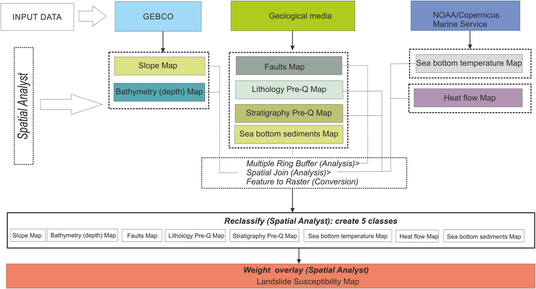
Figure 1. Flowchart of susceptibility modeling of gas hydrates in the Black Sea.
Global gas hydrate inventories have been utilized to estimate the total volumes of gas hydrates worldwide and assess associated risks. These inventories also aid in projecting the potential impacts of future warming scenarios (Piñero et al., 2013). To systemize the existing data on gas hydrate distribution, the GIS project has been created. This project significantly complements previously developed databases and contains information on gas hydrate features of confirmed gas hydrate occurrence. Distribution of these features summarizes the data of different sources of gas hydrate distribution including data from free public databases and project results, such as EMODnet (https://www.emodnet-geology.eu), MIGRATE (https://www.migrate-cost.eu/), GARAH project 731,166, GeoERA-GE-1, H2020 Environment (https://geoera.eu/projects/garah4/) and specific data of academic organizations and publications. The databases hold records, encompassing both vector and raster data, and serve as a repository for information on direct and indirect evidence of gas hydrates. Direct evidence data is sourced from samples documented in various publications. Indirect evidence data includes seismic indicators information on seabed features like gas seepage areas, heat flow data, sediment thickness models, pore water anomalies, models of the base of the gas hydrate stability zone, as well as morphology and bathymetry models.
Inventory maps and databases denote areas identified as being impacted by gas hydrate formation. The level of detail in these maps varies from basic reconnaissance inventories that outline broad areas where gas hydrates appear to occur, to complex inventories that depict and classify specific local zones, indicators and features.
Gas hydrate inventory maps of the Black Sea are prepared for multiple reasons including:
(i) Documenting the extent of gas hydrates phenomena and store hydrate-related geological, geomorphological, geophysical and oceanographic information;
(ii) As a preliminary step toward gas hydrates susceptibility mapping and forecast;
(iii) To investigate the distribution and patterns of gas hydrates concerning geomorphological, geological, and physical characteristics.
Other gas hydrate information includes seabed features (gas seepages areas), heat flow data, sediment models, geology models of pre-Quaternary sediments and rocks with the data on lithology and stratigraphy (EMODnet Geology (https://www.emodnet-geology.eu/map-viewer/, theoretical models of the base of the GHSZ, and relief and bathymetry models. For the analyzing the depths the EMODnet-Bathymetry has been used (https://www.emodnetbathymetry.eu/). It provides a service for viewing and downloading a harmonised Digital Terrain Model (DTM) for the European sea regions. Mean depth in multi-color style with water depth to LAT reference from EMODnet DTM in gridded form over the whole of the maritime basin on a grid of 1/16 * 1/16 arc minutes (ca. 115 m grid) complemented by GEBCO coverage. For some areas, the High-Resolution bathymetry has been used which is a multi-resolution layer. The resolution of HR-DTMs varies between 1/32 and 1/512 arc minutes. The thickness of the GHSZ was taken from Nuñez-Varela et al. (2021) heat flow data are described by Vassilev and Dimitrov (2002). The main tectonic elements and structures of the Black Sea were taken from the EMODnet Geology data and regional tectonics maps.
All the information above has been organized into the following groups:
• Geological evidences/indicators (stratigraphy and lithology of sea bed sediments, tectonics, sea bed geomorphology);
• Fluid flow seabed indicators;
• Oceanographic variables including seafloor temperature data, geothermal gradient data, etc.
4 Results
4.1 Analysis of the factors favoring the occurrence of gas hydrates in the Black Sea
Geological and geomorphological studies and the analysis of gas hydrates have identified a complex relationship between existing geological and geomorphological data and seabed features/indicators for the Black Sea.
4.1.1 Sea bed geomorphology
The vast majority of gas hydrates are confined to depth more than 600–800 m and slopes, the degree of which varies from 4 to 9° (Figure 2). Theoretical calculations regarding the depth and thickness of the gas hydrate zone (Kutas et al., 1992) suggest that the sea bottom sediments of the Black Sea exhibit favorable thermo-baric conditions for the formation and stable persistence of gas hydrates. However, while these conditions are necessary, they are not sufficient on their own. Despite optimistic projections suggesting that the deep-water areas of the Black Sea (at depths exceeding 600–700 m) may be covered by a methane gas hydrate layer, the processes governing gas hydrate formation in the Black Sea basin are significantly more complex. First of all, this concerns the sources and mechanism of formation of gas hydrate accumulations. By our investigations it was confirmed that the findings of gas hydrates in the Black Sea are confined mostly to the continental slope. This spatial distribution is primarily attributed to intense landslide activity in the region, which could play a significant role in hydrate preservation. Landslides contribute to gas hydrate accumulation through several key mechanisms. First, the downslope movement of sediments facilitates rapid burial of gas-charged sediments. This sudden deposition creates an anoxic environment and increases overburden pressure. Additionally, the newly emplaced sedimentary layers act as an insulating cap that protects existing gas hydrates from dissociation. Turbidite flows are especially important in this context. These high-energy gravity-driven flows transport large volumes of sediment downslope, often depositing thick, poorly sorted layers in a short time. Such rapid and massive sedimentation can not only trigger further slope instability but also rapidly bury methane sources and create low-permeability layers that enhance hydrate entrapment. It was investigated that the continental slope in the northwestern part of the Black Sea is characterized by a widespread distribution of methane gas emissions. In this region, the occurrence of methane seeps has been observed, and the seabed areas exhibit the highest fluid and gas dynamics.
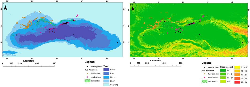
Figure 2. Distribution of gas hydrates, mud volcanoes, and fluid emission superimposed on the morphological zone map (A) and slope map (B) of the Black Sea.
4.1.2 Lithology and stratigraphy of sea bed sediments
The lithology appears also to control the occurrence of the gas hydrates phenomena. It was proven that the degree of sediment heterogeneity and the spatial position of sedimentary layers are the main factors differentiate the types of hydrate formation (Burwicz-Galerne et al., 2024). For spatial analysis of existing hydrates, the geological map of the Black Sea was used (Emodnet geology). Our findings confirm that the majority of gas hydrates are confined to Pre-Quaternary Neogene deposits. Concerning the seabed sediments, a significant number of gas hydrates are found in deposits composed of silty sand and silt sediments (Figure 3).
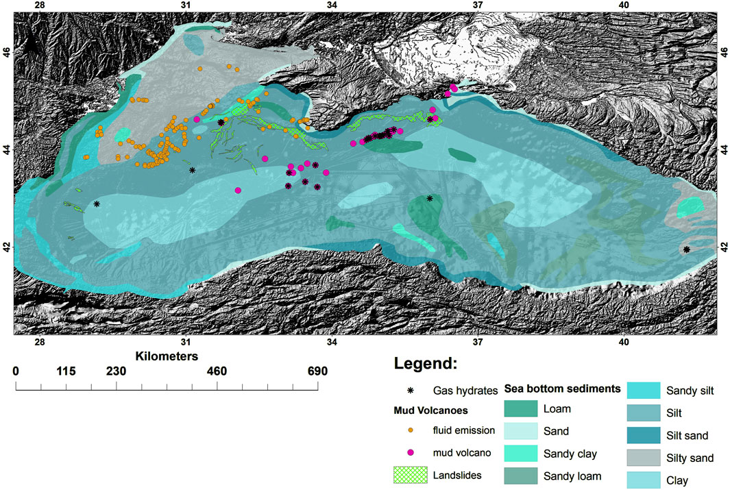
Figure 3. Distribution of the gas hydrates superimposed on the seabed sediments of the Black Sea.
Based on the results of the overlay analysis, the location of gas hydrates within a certain polygon of the specified vector layers was identified and a statistical calculation of the occurrence of gas hydrates was carried out by combining the attribute tables of gas hydrates and the specified layers. A procedure resulted in ranking the area by the number of gas hydrate points within each polygon.
4.1.3 Structural and tectonic factor
To determine the impact of the structural-tectonic factor on the formation of gas hydrates, a detailed analysis of the fault system in the Black Sea was carried out and the priority influence on the gas hydrate phenomena was determined. The fault features were mapped all over the Black Sea (Figure 4A). The corresponding determination of the influence of faults of different nature on the formation of gas hydrates is shown in Figure 4. A significant number of gas hydrate points are localized within a distance of 0–1,000 m from faults (Figure 4).
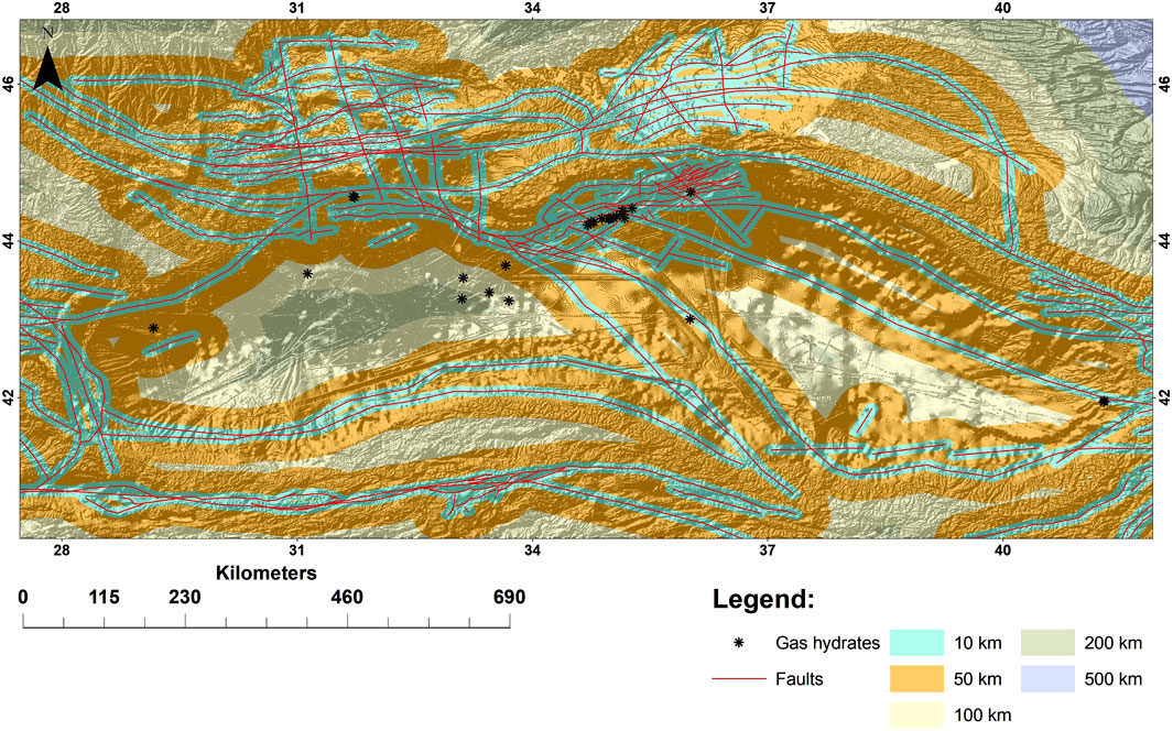
Figure 4. Gas hydrates superimposed on the map of distance to faults in the Black Sea.
The spatial analysis confirms the essential role of faults in the distribution of gas hydrates and the relationship between tectonic structure and pre-conditioning factors for gas hydrates formation (Figure 4). Certain combinations of geological and tectonic conditions result in a complex interplay of fluid flow and tectonic zones, significantly affecting the dynamics and origin of gas hydrates. Within tectonized units associated with active or formerly active faults, rheological conditions favor the manifestation of gas hydrate phenomena. The constructed map of gas hydrates distances concerning faults served as the basis for creating a raster model of the study area, ranking zones based on their proximity to faults (classified into distance categories). The influence of tectonic structures on gas hydrate distribution was quantified through GIS-based overlay analysis, with tectonics assigned the highest weight (0.30) based on expert validation and Pearson’s correlation (r = 0.78, p < 0.001). Hydrate occurrences within 1 km of faults (78% of sites) significantly exceeded those linked to lithology (42%). In particular, the key role of faults as channels of gas emission has been proved. As can be seen in Figure 4 the most of the gas emission zones spatially correspond to the Circum-Black Sea fault zone. Along this zone, there was a significant displacement of the basement and boundary Moho, a change in the thickness, and structure of the earth’s crust, and a dislocation of deep-sea sediments. In the north-western part of the Black Sea with a depth of more than 1,000 m on the traverse of Sevastopol there is a gas hydrates zone of west-north-western extensions. Hydrocarbons flow through a fault zone, which is the north-western extension of the sublatitude fault zone on the shelf and continental slope south of Crimea (Shnyukov et al., 1990).
4.1.4 Association of has hydrates and mud volcanoes
In addition to finds and detection of accumulations of gas hydrates confined to the continental slope, direct observations of gas hydrates in most cases are located spatially within the boundaries of mud volcanic fields, which may indicate their close genetic origins. Mud volcanoes are found in many large geological structures of the Black Sea basin. Some of mud volcanoes have been recorded within the Western Black Sea basin. In deep sea conditions, mud volcanoes are distinguished by newest activity. The dimensions of the largest mud volcanic structures reach 4 km × 2.2 km × 2 km (Shnyukov et al., 1990; Shnyukov and Yanko-Hombach, 2020). Sections of mud volcanoes clearly show the existence of their own mud morphostructures. It must be assumed that the relief of mud volcanoes was formed by newest movements and eruptions. Methane gas hydrates were found in about 60% of the mud volcanoes. According to Byakov and Kruglyakova (2001), the isotopic composition of carbon δ13С – 61.80 to −63.55‰ indicates the mixed and thermal catalytic nature of the hydrocarbons. Overall, the analysis of gas hydrates from mud volcanoes reveals a substantial presence of methane homologues and their derivatives (up to 17%), as well as a significant amount of higher hydrocarbons with more than six carbon atoms (up to 12 components, totaling up to 4.6%), which are not detected in biogenic gases.
In the sedimentary cover of the Black Sea megadepression, there are numerous mud volcanic channels, and possibly other paths of tectonic discontinues, through which powerful flows of deep gases come to the surface.
4.1.5 Gas hydrates and canyons of paleo-rivers
The morphostructural plan of the continental slope of the Black Sea is largely controlled by regional fault zones. These faults are associated with canyons of paleo-rivers such as the paleo-Danube, paleo-Dniester, paleo-Dnipro, and paleo-Kalanchak. Active erosion and denudation within these canyons have led to the formation of large submarine erosion amphitheaters near the edge of the continental slope. The eroded rock complexes form significant areas at the base of corresponding cliffs in terms of thickness and volume. These are marginal deep-water deposition fans, constituting a transitional zone between the continental slope and deep-water basin. They form distinctive ridges, mounds, underwater ridges, and overlaid deposition fans, shaped by turbidity currents. The thickness of these deposition fans reaches several kilometers. It was confirmed that gas emission is abundant along the canyon walls and is strikingly linked to the fault outcrops (Riedel et al., 2021).
Additional controls on gas emission by canyon erosion and slope failure head-scarps exposing gas-bearing sediment layers or providing structural focusing for gas migration were discussed by Riboulot et al. (2017) for the Danube deep-sea fan region, and by Naudts et al. (2006), Shnyukov and Kobolev (2017) for the Dnipro fan system. The canyon was defined to belong to the Dnipro river-fan system. The canyon is ∼2,500 m wide. Gas venting across this canyon system is almost exclusively associated with scarps, with the gas vent sites outlining the canyon walls (Riedel et al., 2021).
Thus, there is no doubt that the most intense localized flow of hydrocarbon fluids is controlled by injectable structures such as faults, diapirs, and mud volcanoes. These structures represent potential pathways for advective fluid transport. The consistent spatial proximity of hydrate accumulations to tectonic lineaments further validated the dominant influence of structural controls compared to other factors. The high correlation observed between hydrate presence and fault intersections further validated the dominant role of tectonics, particularly when cross-referenced with empirical data from previous geological and geophysical surveys.
4.1.6 Oceanic variables
For the analysis of the heat flow and its influence on the formation of gas hydrates (Figure 5), spatial data were analyzed (Vassilev and Dimitrov, 2002). Anomalies in observed heat flow that cannot be explained by factors such as changes in thermal conductivity or sea bottom morphology may be attributed to fluids that have traversed specific sediment layers and to predict the distribution of gas hydrates within the Black Sea basin. This basin exhibits different heat flow values, ranging from 0 to 80 mW/m2. Regions of high apparent heat flow are generally observed in deeper areas, whereas lower heat flow is found along ridges and in the shallower part of the basin.
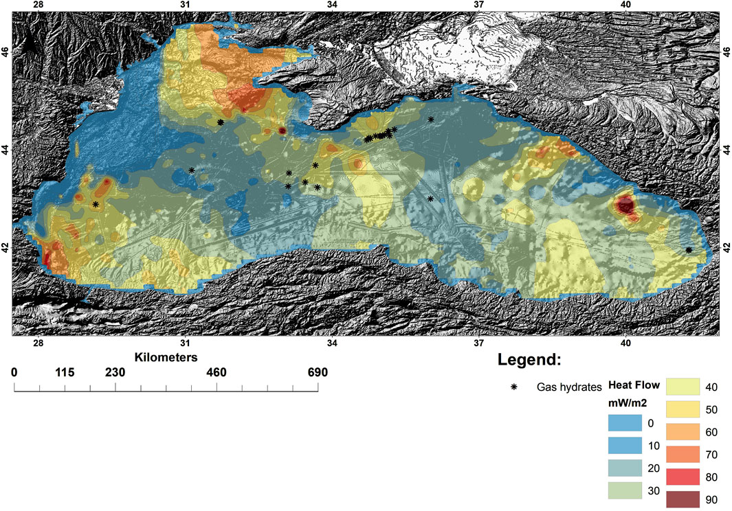
Figure 5. Map of heat flow of the Black Sea (data from Vassilev and Dimitrov, 2002)
The sea bottom temperatures also were considered, showing that values remain nearly constant throughout the deep Black Sea basin, with slight fluctuations around 8.9°C and an amplitude of approximately 0.3°C.
4.2 Gas hydrate susceptibility mapping of the Black Sea
Through cartographic modeling and overlay analysis, a comprehensive analysis of the above-mentioned factors contributing to gas hydrate formation was conducted. Various methods are used for susceptibility mapping in different areas, contributing to sustainable development, increased resilience, and disaster risk reduction (Porwal and Carranza, 2015; Nanehkaran et al., 2023). To reconcile heterogeneous regional geological, geomorphological, and oceanographic datasets (vector, raster, varying resolutions), we implemented a multi-step standardization protocol. To standardize the inputs, all data layers were resampled to a common spatial resolution using ArcGIS tools. Bathymetric grids (EMODnet, 115 m resolution) were resampled using bilinear interpolation to preserve geomorphological gradients, while categorical layers (e.g., lithology) underwent nearest-neighbor resampling to maintain discrete class integrity. Vector fault systems were rasterized to 115 m cells to align with the baseline DTM. In this study we use the overlay analysis is a group of methodologies applied in susceptibility modeling. It is a technique for applying a common scale of values to diverse and dissimilar inputs to create an integrated analysis. Overlay analysis usually requires the analysis of many different factors. Given the constraints in data availability and the limited number of gas hydrate points in the Black Sea basin, it was not feasible to consider all influencing factors simultaneously. Consequently, priority was assigned to geological and geomorphological factors, as well as temperature and heat flow characteristics. Data normalization employed the Jenks Natural Breaks algorithm, minimizing intra-class variance and ensuring uniform contribution to the weighted overlay. This approach aligns with methodologies validated in Yousefi and Carranza (2016) and León et al. (2021), ensuring compatibility across all distinct datasets. Before the multiple factors can be combined for analysis, each must be reclassified or transformed to a common ratio scale. Therefore, each factor was ranked according to its degree of correlation with gas hydrate point density. Objects within each layer (factor) were classified on a unified scale (ranking from 1 to 5) to assess their impact on gas hydrate distribution (Figures 6A–C). Weighting coefficients (informativeness coefficients) were calculated to determine the impact of each factor on gas hydrate formation. A weighting coefficient is a numerical value representing the relative significance of various factors according to decision-maker’s preferences. These coefficients are essential for effective modeling. For each criterion, assign a weighting coefficient that reflects its significance relative to other criteria. These weights can be determined through expert judgment, surveys, or statistical methods. For this study, weighting coefficients were determined through expert judgment and pairwise correlation analysis. To ensure consistency in analysis, all input data were standardized to avoid distortions caused by differing measurement units or scales. To validate expert rankings, Pearson’s correlation coefficients were calculated between each factor. For example, fault proximity showed a strong correlation (r = 0.78), reinforcing its high weight. Continuous variables (e.g., heat flow) were standardized using z-score normalization to remove scale-related bias, while categorical variables (e.g., lithology) were reclassified into five ordinal classes using Jenks Natural Breaks to maximize intra-class consistency. This dual data processing approach adheres to ISO/IEC 25012 data quality standards and is consistent with methodologies validated in hydrate-bearing settings such as the Nankai Trough (Yousefi and Carranza, 2016). In the Black Sea, z-scores highlighted heat flow anomalies (z > 1.5) associated with active fault systems, and lithology reclassification identified silty sands (Class 4) as key hydrate-hosting facies, in agreement with core data (Figure 3). The resulting model achieved high predictive performance (AUC = 0.89), underscoring the robustness of this integrated standardization framework. The pairwise correlation coefficients of gas hydrate-related parameters were computed, confirming the reliability of the weighting approach. These coefficients were then used to generate the proximity matrix, from which the information coefficients were derived. Combine the weighted criteria layers through overlay techniques, where each layer is multiplied by its corresponding weight. These layers were combined to create an integrated gas hydrate susceptibility map that provides a comprehensive spatial assessment of potential gas hydrate occurrences. It is important to note that assigning weighting coefficients required clarifications and adjustments due to the step-by-step grouping of factors and the use of expert assessments, incorporating data from analytical studies.
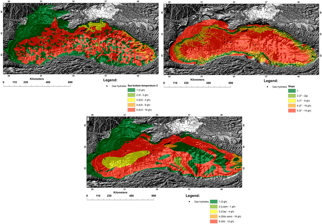
Figure 6. Reclassification of raster data for weighted overlay analysis: reclassified data of the sea bottom temperature (A), slope (B), and sediment map (C).
In overlay analysis, it is desirable to establish the relationship of all the input factors together to identify the possible abundance of gas hydrates that meet the goals of the model. For example, the input layers, once weighted appropriately, have been added together in an additive weighted overlay model. In this combination approach, it is assumed that the more favorable the factors, the more potential location of gas hydrates will be. Thus, the higher the value on the resulting output raster, the more potential the location will be. Other combining approaches could be applied. Alternative fusion approaches, such as fuzzy logic overlay analysis, have been tested to explore the possibility of integrating multiple probability sets. This analysis can be help to explore the possibility of locating up to several sets. However, this method was found to be less effective for prioritization at the regional level compared to the weighted overlay model. The integrated gas hydrate susceptibility map (Figure 7) was created using overlay analysis, which simultaneously considers all factors, providing new spatial information and a comprehensive gas hydrates distribution model for the Black Sea.
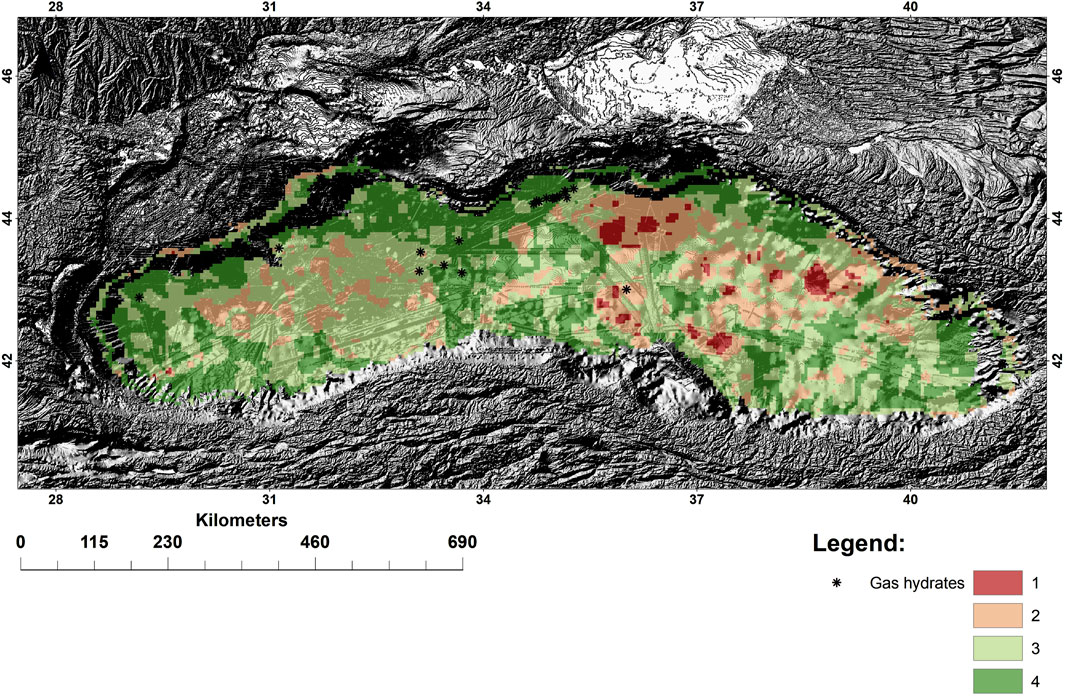
Figure 7. Gas hydrate susceptibility map, Black Sea: 1- low, 2- moderate, 3- high, 4 – very high.
The gas hydrate susceptibility map depicts areas with potential for gas hydrate formation, determined by correlating key contributing factors with existed gas hydrate distribution. Susceptibility measures the likelihood of gas hydrate occurrence in specific areas. Mathematically, susceptibility is defined as the probability of spatial occurrence of gas hydrate formation given a set of geological and physical conditions.
The results highlight the overall impact of geological, geomorphological, and physical factors on gas hydrate formation. A comprehensive analysis of gas hydrates, including their formation and dynamics, requires in-depth studies to determine the influence of each factor on this process. Dynamic factors, in particular, can significantly alter the combination and relative importance of these influences in gas hydrate formation. It's important to note that this analysis focused on understanding the geological and geomorphological factors involved in gas hydrate phenomena. However, other dynamic factors, which are often unpredictable, introduce variability into the analysis. These factors cannot be reliably used as forecasting or reference criteria and require additional research in each specific case. Consequently, they necessitate adjustments to the gas hydrate model and the related susceptibility assessments.
5 Discussion
In this article, we emphasize the role of susceptibility modeling as a preliminary step in the forecasting of gas hydrates. Susceptibility modeling indeed plays a crucial role in identifying areas where gas hydrates are likely to occur, and it provides a valuable tool for prioritizing areas for further investigation efforts. Although GIS-based susceptibility modeling has proven efficient and successful in various exploration fields (Yousefi and Carranza, 2016; Porwal and Carranza, 2015), this approach has not yet been widely applied to gas hydrate assessment in the Black Sea. According to the results on the seafloor’s susceptibility to the presence of hydrate deposits and the associated dissociation hazards, such as liquefaction, explosions, collapses, crater-like depressions, and submarine landslides on the European continental margins, the Black Sea was identified as the region with the highest susceptibility. The susceptibility assessment was based on geological and geophysical evidence, along with indicators of marine gas hydrates within the theoretical GHSZ, which serve as the primary controlling factors (León et al., 2021). This study will allow us to make definitive conclusions about specific geological and geodynamic conditions necessary to ensure the most efficient methods and techniques of gas hydrate analysis. Our research has enabled the identification and ranking of areas of gas hydrate susceptibility in the Black Sea with a higher degree of detail, taking into account geological and oceanographic characteristics.
The gas hydrate susceptibility map of the Black Sea, developed as the core outcome of this study, presents a spatially explicit assessment of regions with varying likelihoods of gas hydrate occurrence. The map was constructed through a multi-criteria GIS-based overlay analysis, integrating key geological, geophysical, geomorphological, and oceanographic factors that control gas hydrate formation and distribution. Each contributing factor was standardized to a uniform scale, ranked according to its relative influence, and assigned a weight derived from expert evaluation and statistical correlation with known gas hydrate occurrences. The final susceptibility map displays susceptibility values on a continuous scale, classified into four categories: low, moderate, high, and very high susceptibility. These categories were defined using the Jenks Natural Breaks classification method, which minimizes intra-class variance and maximizes inter-class differences, ensuring a meaningful delineation of spatial patterns. Areas of very high susceptibility are predominantly located along the northwestern and western continental slopes of the Black Sea, particularly in proximity to the Danube, Dniester, and Dnipro paleo-canyons, where active faulting, steep slope gradients, and high sediment accumulation rates converge. These zones are characterized by elevated heat flow anomalies, intensive gas seepage, and frequent presence of mud volcanoes and diapiric structures. The abyssal regions of the basin are generally classified as having low to moderate susceptibility due to the absence of well-developed migration pathways, minimal fluid flux, and homogeneous lithological properties of sediments. Similarly, shelf regions and shallow continental areas exhibit low susceptibility, primarily due to insufficient pressure and temperature conditions to maintain gas hydrate stability within the upper sediment layers. The map highlights a strong spatial correlation between tectonic lineaments, mud volcanic fields, and zones of confirmed gas hydrate occurrences, further reinforcing the structural control on hydrate accumulation. Zones with the highest susceptibility correspond well with documented hydrate-bearing sites, demonstrating the predictive validity of the model (AUC = 0.89). Additionally, rasterized proximity layers of fault systems and lithostratigraphic facies were found to be the most influential input parameters, consistent with earlier studies in analogous marine basins.
However, it's essential to recognize that susceptibility modeling has limitations (Leon et al., 2020; León et al., 2021) and should be complemented with more detailed, site-specific information. The uncertainty analysis of the susceptibility inference reveals large seafloor regions lacking data and areas with a very low data density, which are identified as significant knowledge gaps (Váquez-Izquierdo et al., 2018). Key to addressing these gaps is the targeted acquisition of high-resolution geophysical and geochemical data through focused field campaigns and expeditions in under-sampled regions. Specifically, increasing seafloor-mapping efforts using advanced techniques will provide more detailed information on seafloor morphology and sediment characteristics. Additionally, the collection of core samples from previously underexplored areas will allow for better characterization of sediment types, hydrate presence, and the geotechnical properties of the seafloor. Furthermore, the integration of multidisciplinary data (geophysical, geochemical, and geological) will be crucial for refining the model in these low-data-density regions. As a potential action, collaborative data integration could be achieved by sharing model outputs through platforms such as EMODnet and DOORS, thereby promoting transparency and wider accessibility.
The presence and dissociation of gas hydrates are recognized as potential triggers for slope failure, turbidite formation, and submarine landslides. Analysis of multiple databases indicates a significant variability in the distribution and frequency of submarine landslides. A review of relevant literature further supports a causal relationship between gas hydrate dissociation and the destabilization of submarine slopes, as well as the occurrence of other geotechnical hazards (Sultan and Garziglia, 2024; Mitropolsky, 2013). To investigate slope instability within gas hydrate-bearing zones, an integrated analysis was conducted based on data from the R/V Mare Nigrum (Cruise MN 249). During this expedition, sediment cores were retrieved using a gravity corer from various sites in the Black Sea. The cores predominantly consisted of deep-sea sediments, including sands, silts, sapropels, clays, and turbidites. Evidence of submarine landslides was identified within these cores. Notably, at Station Karota F2 (1,116 m depth), the sediment core revealed characteristic landslide textures (Figure 8). At a depth of 0.43–0.50 m, the upper boundary of a displaced layer of gray sands within soft plastic silts is clearly delineated. The upper portion of the compacted sand block is acutely deformed, while the lower boundary rests upon a smooth clay-rich flysch layer. The deformation patterns observed suggest that these submarine landslides may be associated with changes in sediment mechanical properties induced by gas hydrate dissociation. Additionally, turbiditic sequences (flysch) were observed, characterized by interbedded light gray pelitic silts and darker fine-grained gray sands. This interpretation is consistent with existing studies that link hydrate dissociation to elevated pore pressure and a subsequent reduction in effective stress, which can compromise slope stability and induce sediment deformation (Iwai et al., 2015).
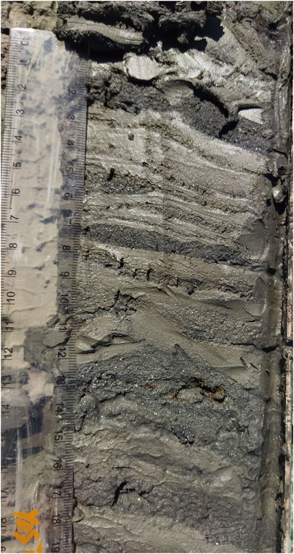
Figure 8. Gravity core, station Karota F2, 1,116 m (43°25.453′N, 29°34.304′E). The sediment core revealed characteristic landslide textures. The upper part is presented by gray sands in soft plastic silts; the bottom is located on a smooth clay flysch layer. Turbidites (two-component flysch) interbedding of light gray pelitic silts with darker fine-grained gray sands.
6 Conclusion
The developed model presented is a first-stage tool within a broader integrated framework for gas hydrate assessment along the European continental margin. It provides a generalized and transferable methodology applicable to both exploration and geohazard risk mitigation.
This study provides a comprehensive, scientifically grounded framework for regional-scale gas hydrate susceptibility assessment in the Black Sea, utilizing a multi-criteria GIS-based modeling approach. By integrating geological, geophysical, geomorphological, and oceanographic data, the research offers a nuanced understanding of the spatial distribution of gas hydrates and the underlying mechanisms that govern their formation, migration, and stability in the basin.
The methodology employed in this study combines both empirical and expert-driven approaches, including overlay analysis, spatial correlation techniques, and weighting coefficient assignment based on Pearson correlation analysis and domain-specific expertise. This hybrid approach enabled the construction of a susceptibility model, which demonstrated significant predictive capacity and provided robust spatial delineation of areas with varying degrees of gas hydrate formation potential.
The results underscore the primacy of tectonic structures, particularly fault systems, as conduits for hydrocarbon migration and as critical determinants of gas hydrate emplacement. The Circum-Black Sea fault zone, in particular, plays a central role in controlling subsurface fluid dynamics, leading to enhanced gas flux and hydrate accumulation. The analysis further confirms the association of gas hydrates with specific geomorphological settings, notably continental slopes with gradients between 4°–9°, and depositional features such as paleo-river canyons and deep-sea fans.
The lithological control on hydrate formation was also evident, with a high concentration of gas hydrate points found within Pre-Quaternary Neogene silty sand and silt-rich sediments, reinforcing the importance of porosity-permeability contrasts and sediment heterogeneity in facilitating gas entrapment. Stratigraphic layering and sediment compaction further influence hydrate stability, particularly in areas with active sedimentation or mass wasting events. In addition to static geological parameters, the model incorporated oceanographic variables such as bottom water temperature and heat flow.
The resulting susceptibility map provides a strategic tool for identifying zones of heightened gas hydrate potential and associated geohazards, including submarine landslides and slope instability induced by hydrate dissociation.
Ultimately, this study lays the groundwork for a scalable and transferable methodology for gas hydrate assessment that can be adapted to other continental margins. It establishes a solid baseline for future research aimed at refining our understanding of gas hydrate systems in complex geological environments. The model offers considerable practical utility for environmental monitoring, marine spatial planning, and resource exploration, particularly in the context of the EU’s Marine Strategy Framework Directive (MSFD). It enables risk-informed decision-making regarding infrastructure development and offshore operations by delineating exclusion zones and geohazard-prone areas. By offering spatially resolved and policy-relevant outputs, the developed model strengthens preparedness for marine geohazards and supports the strategic management of potential gas hydrate resources in the Black Sea and other comparable marine environments.
Data availability statement
The raw data supporting the conclusions of this article will be made available by the authors, without undue reservation.
Author contributions
VI: Conceptualization, Funding acquisition, Investigation, Methodology, Project administration, Resources, Supervision, Validation, Writing – original draft, Writing – review and editing. OI: Conceptualization, Data curation, Formal Analysis, Investigation, Methodology, Software, Supervision, Validation, Visualization, Writing – original draft, Writing – review and editing. TK: Data curation, Formal Analysis, Investigation, Project administration, Resources, Writing – review and editing. NF: Data curation, Formal Analysis, Investigation, Project administration, Writing – review and editing. IS: Investigation, Visualization, Writing – review and editing. EP: Formal Analysis, Software, Visualization, Writing – review and editing. KH: Formal Analysis, Investigation, Software, Visualization, Writing – review and editing.
Funding
The author(s) declare that financial support was received for the research and/or publication of this article. This study was funded by the European Union’s Horizon 2020 research and innovation programme (grant agreement No. 101000518, project DOORS).
Acknowledgments
The authors express their gratitude to all those involved in DOORS project. They also gratefully acknowledge the support of the Fulbright U.S. Scholar Program, sponsored by the U.S. Department of State, as part of the project “Assessment of Landslide Hazards at Regional and Local Scale and Impact on Communities.” The content is solely the responsibility of the authors and does not necessarily represent the official views of the Fulbright Program or the U.S. Government.
Conflict of interest
The authors declare that the research was conducted in the absence of any commercial or financial relationships that could be construed as a potential conflict of interest.
Generative AI statement
The author(s) declare that no Generative AI was used in the creation of this manuscript.
Publisher’s note
All claims expressed in this article are solely those of the authors and do not necessarily represent those of their affiliated organizations, or those of the publisher, the editors and the reviewers. Any product that may be evaluated in this article, or claim that may be made by its manufacturer, is not guaranteed or endorsed by the publisher.
References
Bazaluk, O., Sai, K., Lozynskyi, V., Petlovanyi, M., and Saik, P. (2021). Research into dissociation zones of gas hydrate deposits with a heterogeneous structure in the Black Sea. Energies 14 (5), 1345. doi:10.3390/en14051345
Biastoch, A., Treude, T., Rüpke, L. H., Riebesell, U., Roth, C., Burwicz, E. B., et al. (2011). Rising Arctic Ocean temperatures cause gas hydrate destabilization and ocean acidification. Geophys. Res. Lett. 38, 5. doi:10.1029/2011GL047222
Burwicz-Galerne, E., Haeckel, M., Hensen, C., Samant, R., and Wallmann, K. (2024). The gas hydrate system of the western Black Sea Basin. Mar. Petroleum Geol. 168, 107026. doi:10.1016/j.marpetgeo.2024.107026
Byakov, Yu.A., and Kruglyakova, R. P. (2001). Gas hydrates of the sedimentary strata of the Black Sea – hydrocarbon raw materials of the future. Explor. Prot. Mineral Resour. 8, 14–19.
Collett, T., Johnson, A. H., Knapp, C., and Boswell, R. (2009). Natural gas hydrates: a review. Tulsa, OK: AAPG Memoir, 146–219. doi:10.1306/13201142m891602
Collett, T. S., and Lee, M. W. (2000). Reservoir characterization of marine and permafrost associated gas hydrate accumulations with downhole well logs. Ann. N. Y. Acad. Sci. 912, 51–64. doi:10.1111/j.1749-6632.2000.tb06759.x
Efremova, A., and Zhizhchenko, B. (1974). Recognition of gas crystallohydrates in sediments of recent aquatoria. Dokl. SSSR 214 (5), 1179–1181.
Mitropolsky, A. Y. (2013). Geoecological, hydroacoustic, hydroecological studies of the shelf and continental slope of the Ukrainian sector of the Black Sea. Kyiv.
Gevorkyan, B., Burakov, V., Isagulova, U., Semenov, D., Malakhov, V., Olepnik, F., et al. (1991). Gas venting buildups on the seafloor of the North-Western Black Sea part. Dokl. Ukrainy. Geol. 4, 80–85.
Gozhyk, P. F., Bahrii, I. D., Voitsytskyi, Z.Ya., Hladun, V. V., Maslun, N. V., Znаmenska, T. O., et al. (2010). Geological, structural, thermal, and atmogeochemical justification of petroleum potential in the Azov–Black Sea area. Kyiv Logos.
Gupta, S., Burwicz-Galerne, E., Schmidt, C., and Rüpke, L. (2023). Periodic states and their implications in gas hydrate systems. Earth Planet Sci. Lett. 624, 118445. doi:10.1016/j.epsl.2023.118445
Haeckel, M., Zander, T., Burwicz, E., Bialas, J., Berndt, C., Dannowski, A., et al. (2017). “The gas hydrate system of the Danube deep-sea fan in the Black Sea,” in 9th International conference on gas hydrates. Denver, CO, June 15–30, 2017. Colorado School of Mines.
Iwai, H., Kimoto, S., Akaki, T., and Oka, F. (2015). Stability analysis of methane hydrate-bearing soils considering dissociation. Energies 8, 5381–5412. doi:10.3390/en8065381
Klymenko, V., Ovetskyi, S., Martynenko, V., Vytiaz, O., and Uhrynovskyi, A. (2022). An alternative method of methane production from deposits of subaquatic gas hydrates. Min. Min. Depos. 16 (3), 11–17. doi:10.33271/mining16.03.011
Körber, J. H., Sahling, H., Pape, T., dos Santos Ferreira, C., MacDonald, I. R., and Bohrmann, G. (2014). Natural oil seepage at Kobuleti ridge, eastern Black Sea. Mar. Petrol. Geol. 50, 68–82. doi:10.1016/j.marpetgeo.2013.11.007
Kretschmer, K., Biastoch, A., Ruepke, L., and Burwicz, E. (2015). Modeling the fate of methane hydrates under global warming. Glob. Biogeochem. Cycles 29 (5), 610–625. doi:10.1002/2014gb005011
Kutas, R. I., Kobolev, V. P., Tsvyashchenko, V. A., Vassilev, A. D., and Kravchuk, O. P. (1992). New determination of heat flow in the Bulgarian sector of the Black Sea. Dokl. Akad. Nauk. Ukr. 7, 104–107.
Kuustraa, V. A., and Hammershaimb, E. C. (1983). Report No.: DOE/MC/19452–3114. Handbook of gas hydrate properties and occurrence. Morgantown, WV: U.S. Department of Energy, 357.
León, R., Llorente, M., and Giménez-Moreno, C. J. (2021). Marine gas hydrate geohazard assessment on the European continental margins. The impact of critical knowledge gaps. Appl. Sci. 11, 2865. doi:10.3390/app11062865
Leon, R., Rochelle, C., Burnol, A., Gimenez-Moreno, C. J., Nielsen, T., Hopper, J., et al. (2020). “Pan-European GIS focused on gas hydrates: a research base-line in geohazards and geological storage of CO2,” in Proceedings of the copernicus meetings, EGU general assembly 2020. 4–8 May 2020.
Makogon, Y., Holditch, S., and Makogon, T. (2007). Natural gas hydrates – a potential energy source for the 21st Century. J. Petroleum Sci. Eng. 56 (1-3), 14–31. doi:10.1016/j.petrol.2005.10.009
Mienert, J., Berndt, C., Tréhu, A. M., Camerlenghi, A., and Liu, C. S. (2022). World atlas of submarine gas hydrates in continental margins (Springer Nature). doi:10.1007/978-3-030-81186-0
Nanehkaran, Y. A., Chen, B., Cemiloglu, A., Chen, J., Anwar, S., Azarafza, M., et al. (2023). Riverside landslide susceptibility overview: leveraging artificial neural networks and machine learning in accordance with the united nations (UN) sustainable development goals. Water (Basel). 15, 2707. doi:10.3390/w15152707
Naudts, L., Greinert, J., Artemov, Y., and De Batist, M. (2009). Geo- and hydro-acoustic manifestations of shallow gas and gas seeps in the Dnepr paleodelta, northwestern black sea. Lead. Edge 28 (9), 1030–1040. doi:10.1190/1.3236372
Naudts, L., Greinert, J., Artemov, Y., Staelens, P., Poort, J., Van Rensbergen, P., et al. (2006). Geological and morphological setting of 2778 methane seeps in the Dnepr paleo-delta, northwestern black sea. Mar. Geol. 227, 177–199. doi:10.1016/j.margeo.2005.10.005
Nuñez-Varela, E., Pérez, L. F., León, R., Martin, D. A., and Reguera, M. I. (2021). Impact of bottom water temperature on the theoretical hydrate stability zone along the European continental margins, X Congreso Nacional de Geología. Spain: Vitoria-Gasteiz.
Piñero, E., Marquardt, M., Hensen, C., Haeckel, M., and Wallmann, K. (2013). Estimation of the global inventory of methane hydrates in marine sediments using transfer functions. Biogeosciences (BG) 10 (2), 959–975. doi:10.5194/bg-10-959-2013
Porwal, A., and Carranza, E. J. M. (2015). Introduction to the Special Issue: GIS-based mineral potential modelling and geological data analyses for mineral exploration. Ore Geol. Rev. 71, 477–483. doi:10.1016/j.oregeorev.2015.04.017
Reeburgh, W. S., Ward, B. B., Whalen, S. C., Sandbeck, K. A., Kilpatrickt, K. A., and Kerkhof, L. J. (1991). Black Sea methane geochemistry. Oceanogr. Res. Pap. 38 (2), 1189–1210. doi:10.1016/S0198-0149(10)80030-5
Riboulot, V., Cattaneo, A., Scalabrin, C., Gaillot, A., Jouet, G., Ballas, G., et al. (2017). Control of the geomorphology and gas hydrate extent on widespread gas emissions offshore Romania. Bull. Soc. Géol. Fr. 188 (4), 26. doi:10.1051/bsgf/2017182
Riedel, M., Hähnel, L., Bialas, J., Bachmann, A., Gaide, S., Wintersteller, P., et al. (2021). Controls on gas emission distribution on the continental slope of the western Black Sea. Front. Earth Sci. 8, 601254. doi:10.3389/feart.2020.601254
Ruppel, C. (2011). Methane hydrates and contemporary climate change. Nat. Edu. Know. 3 (10), 29. Available online at: https://www.nature.com/scitable/knowledge/library/methane-hydrates-and-contemporary-climate-change-24314790/
Sanjeev, R., and Naresh, T. (2016). Tectonics and gas hydrates. doi:10.1016/B978-0-12-802020-3.00004-7
Schmidt, C., Gupta, S., Rupke, L., Burwicz-Galerne, E., and Hartz, E. H. (2022). Sedimentation-driven cyclic rebuilding of gas hydrates. Mar. Petrol. Geol. 140, 105628. doi:10.1016/j.marpetgeo.2022.105628
Shnyukov, E., Grigoriev, A., Mitin, L., and Kleshchenko, S. (1990). Results of geological investigations during the 51 cruise of R/V M. Lomonosov in the Black Sea. Kiev: Institute of Geological Sciences.
Shnyukov, E., Mitin, L., and Kleshchenko, S. (1993). Zone of acoustic anomalies in the Black Sea near Sevastopol. Geol. J. 3, 62–67.
Shnyukov, E. F., and Kobolev, V. P. (2017). Gas hydrates of the Black sea – potential source of energy (analytical review). Geol. mineral Resour. World ocean 3, 5–23.
Shnyukov, S., and Yanko-Hombach, V. (2020). Mud volcanoes of the Black Sea region and their environmental significance. 1st ed. Springer.
Starostenko, V., Rusakov, O., Shnyukov, E., Kobolev, V., and Kutas, R. (2010). Methane in the northern Black Sea: characterization of its geomorphological and geological environments. J. Geol. Soc. Lond. Spec. Publ. 340, 57–75. doi:10.1144/SP340.5
Sultan, N., and Garziglia, S. (2024). 3D stability analysis of submarine slopes: a probabilistic approach incorporating strain-softening behaviour. Landslides 21, 2695–2709. doi:10.1007/s10346-024-02317-6
Váquez-Izquierdo, A., Gimenez-Moreno, C.-J., and León, R. (2018). Knowledge gaps in gas-hydrate assessment: theoretical considerations and practical implications. Geophys. Res. 20, EGU2018–12847. Available online at: https://meetingorganizer.copernicus.org/EGU2018/EGU2018-12847.pdf
Vassilev, A., and Dimitrov, L. (2002). Spatial and quantity evaluation of the Black sea gas hydrates. Geol. Geofizika 43 (7), 672–684. Available online at: https://www.researchgate.net/publication/313105877_Spatial_and_quantity_evaluation_of_the_Black_Sea_gas_hydrates
Wallmann, K., Riedel, M., Hong, W. L., Patton, H., Hubbard, A., Pape, T., et al. (2018). Gas hydrate dissociation off Svalbard induced by isostatic rebound rather than global warming. Nat. Commun. 9 (83), 83. doi:10.1038/s41467-017-02550-9
Wang, H., Zhang, L., He, J., and Zhou, T. (2022). The development of natural gas hydrate exploitation Technology from perspective of patents. Front. Energy Res. 10, 860591. doi:10.3389/fenrg.2022.860591
Yousefi, M., and Carranza, E. J. M. (2016). Data-driven index overlay and boolean logic mineral prospectivity modeling in greenfields exploration. Nat. Resour. Res. 25, 3–18. doi:10.1007/s11053-014-9261-9
Keywords: Black Sea, gas hydrates, susceptibility modeling, geohazards, sea bed sediments
Citation: Iemelianov V, Ivanik O, Kukovska T, Fedoronchuk N, Shuraiev I, Petrushenko E and Hadiatska K (2025) Modeling and forecast of gas hydrate distribution in the Black Sea: main principles and approaches. Front. Earth Sci. 13:1518758. doi: 10.3389/feart.2025.1518758
Received: 28 October 2024; Accepted: 28 May 2025;
Published: 23 June 2025.
Edited by:
Ewa Burwicz-Galerne, University of Bremen, GermanyReviewed by:
Pavlo Saik, Dnipro University of Technology, UkraineMohammad Azarafza, University of Tabriz, Iran
Livio Ruffine, IFP Energies nouvelles, France
Copyright © 2025 Iemelianov, Ivanik, Kukovska, Fedoronchuk, Shuraiev, Petrushenko and Hadiatska. This is an open-access article distributed under the terms of the Creative Commons Attribution License (CC BY). The use, distribution or reproduction in other forums is permitted, provided the original author(s) and the copyright owner(s) are credited and that the original publication in this journal is cited, in accordance with accepted academic practice. No use, distribution or reproduction is permitted which does not comply with these terms.
*Correspondence: Olena Ivanik, b20uaXZhbmlrQGdtYWlsLmNvbQ==