 Yuhao Huang
 Zehui Shi
 Yile Chen
 Kai Zhou
 Ziyi Ying
 Liang Zheng
 Shuai Yang
- 1Faculty of Innovation and Design, City University of Macau, Taipa, Macao, SAR China
- 2Faculty of Literature and Art, Ningxia Institute of Science and Technology, Shizuishan City, Ningxia, China
- 3Faculty of Humanities and Arts, Macau University of Science and Technology, Taipa, Macao, SAR China
- 4Institute of Architectural History and Theory, School of Architecture and Urban Planning, Chongqing University, Chongqing, China
- 5School of Art and Archaeology, Hangzhou City University, Hangzhou, China
The traditional form of a water town is the result of a combination of urban history, culture, and spatial structure. This study digitized historical maps of ancient Wenzhou City from four developmental periods (1566, 1765, 1876, and 1949); employed space syntax to compute the integration, choice, and intelligibility of the road and water networks; and categorized and annotated the architecturally functional attributes of the ancient city using geographic information systems software. The findings indicate that (1) ancient Wenzhou City’s morphological development gradually transitioned from a singular, enclosed urban configuration to a decentralized, open urban framework, with urban functions evolving from defensive to economic and multipurpose. (2) The street structure and the water network axis in the ancient city reflected three stages of urban morphological evolution, namely, the defense-oriented stage (1566), the commercial expansion stage (1765–1876), and the modernization transformation stage (1949). (3) The architecturally functional attributes of the ancient city of Wenzhou evolved from being defense dominated to coexisting commercial, residential, industrial and other functional uses. This study provides a systematic research framework for the spatial structure evolutionary law and functional layout characteristics of ancient water towns and provides a reference case for planning strategies and the protection of ancient water towns.
1 Introduction
1.1 Research background
Ancient Wenzhou City, a typical ancient water town in China’s Yangtze River Delta region, has a long history and unique urban spatial structure. The city is an important study object for three reasons: (1) the shipping network formed by the Ou River and Tanghe River systems makes it an important trade node on the Maritime Silk Road; (2) the U-shaped city wall and the “water and land dual-track” street system reflect the dual needs of military defense and the inland river economy; and (3) the “front shop and back workshop” commercial settlements distributed along the river reflect the urban‒rural economic model dominated by water transportation (Gu et al., 2011; Lin and Li, 2019). Currently, rapid urbanization is impacting the spatial structure of the ancient city: between 2010 and 2020, the density of historical buildings in the core area of the ancient city decreased by 23%, and the water and land transportation functions were replaced by motor vehicle roads. This study quantitatively analyzed spatial data from four key transformational periods to reveal how the functional changes in defense, commerce, and industry reconstructed the urban form, providing a basis for balancing heritage protection and modern development.
As urbanization accelerates, ancient Wenzhou City faces the challenge of protecting its traditional culture and spatial structure in the modernization process. Rapid urban development has gradually eroded the spatial structure of Wenzhou’s ancient city, intensifying the conflict between traditional water town characteristics and modern architecture. Furthermore, the crucial problem has arisen of resolving the urgent problem of balancing the protection of historical and cultural heritage with the functional needs of modern cities. A space syntax analysis is an effective tool for understanding these complex spatial changes (Serra and Pinho, 2013). However, the complexity and diversity of these techniques introduce new research problems and technical difficulties that require interdisciplinary cooperation and in-depth research. Therefore, the study of the historical morphological evolution and transformation of ancient cities has attracted great attention from experts and scholars from many fields—such as urban planning, historical geography, cultural heritage protection, and sociology—and has gradually formed a multidisciplinary, cross-disciplinary research field. This study provides both a scientific basis for the protection and development of the ancient city of Wenzhou and a reference for other water towns with similar spatial structures and historical backgrounds.
1.2 Literature review
1.2.1 Previous research conducted on traditional Chinese water towns
As a typical type of ancient town, traditional water towns inherit unique water networks, street layouts, and cultural characteristics and have become an important subject for studying the urban form, economic structure, and cultural heritage of ancient China. Academic research on traditional water towns has explored the background of their formation, spatial layout, social economy, and cultural characteristics. With respect to the formation background and geographical environment of ancient water towns, Chen et al. (2018) noted that the formation of traditional Chinese water towns is closely linked to their unique geographical environments (Chen et al., 2018). These ancient cities, which are primarily distributed in the Jiangnan region of the lower reaches of the Yangtze River, have developed a water-based transportation network by drawing on the geographical features of dense water networks and interlaced rivers. Huang et al. (2021) and Zingraff-Hamed et al., (2021) generally believe that rivers are both the natural basis for the formation of these ancient cities and an important factor in promoting their economic development (Huang et al., 2021; Zingraff-Hamed et al., 2021). Luo et al. (2021) believe that this water-dominated geographical environment directly affects the location, layout, and development direction of a city (Luo et al., 2021).
With respect to the spatial layout of ancient water towns, Kondolf and Pinto, 2017 and Porfyriou (2019) note that such cities have formed a unique pattern of “building on the water, with streets in front and rivers in the back, and deep houses and courtyards” (Kondolf and Pinto, 2017; Porfyriou, 2019). Zhang et al. (2024b) posits that ancient water towns typically utilize rivers as their veins, implementing a “water and land dual-route” urban structure, in which waterways and land roads develop parallel lines, and streets, bridges, and rivers collectively form the basic framework of the city (Zhang et al., 2024a); Wang and Nolf, 2020; Qier et al. (2023) agree that the layout of markets and residential houses in ancient water towns, primarily developed along rivers, forms an economic and residential model of “front shop and back workshop” (Qier et al., 2023; Wang and Nolf, 2020). This model reflects both the economic characteristics of ancient water towns and their unique spatial organization. However, most studies on the socioeconomic structure of ancient water towns have focused on the development of their commerce and handicrafts. According to Pirenne (2014), ancient water towns became economic centers because of their water transportation developments and prosperous commercial trade (Pirenne, 2014). In addition, these ancient towns are often handicraft distribution centers, with handicraft workshops distributed along the river and water transportation that facilitates product transportation to more relaxed markets (Jinmin and Xiaoxiang, 2022). These economic activities supported both the prosperity of the ancient cities and the expansion of towns as well as population gathering.
In terms of cultural characteristics, ancient water towns are famous for cultivating local culture and living customs. Farhan et al. (2020) reported that these ancient cities act as economic and transportation centers as well as core areas for cultural inheritance and dissemination (Farhan et al., 2020). The ancient water towns represented by the Jiangnan region have nurtured a unique water town culture, including elements such as their architectural styles, folk customs, and religious beliefs (Dong et al., 2024). Cultural festivals are reflected in the architectural layout, traditional culture, religious rituals, and other aspects of the ancient cities, forming a unique cultural landscape in southern China. Ancient water towns face the dual challenges of protection and development as modernization advances. In recent years, scholars have paid increasing attention to protecting ancient water towns’ traditional features and cultural heritages in the context of modernization (Zhang et al., 2024b). Vythoulka, Anastasia and Ancuța, Cătălina have examined the sustainable development of ancient cities through legal protection, research and discussion, community participation, tourism development, and other methods (Ancuța and Jucu, 2023; Vythoulka et al., 2021). Additionally, research has gradually increased on the heritage tourism development of ancient water towns, with discussions focusing on how to balance the relationship between cultural protection and economic development (Shen and Chou, 2022). Overall, as a unique urban type, research on traditional Chinese water towns covers many aspects, such as the geographical environment, spatial layout, socioeconomics, cultural characteristics, and protection and development. The existing research results provide an important theoretical basis for understanding the formation and evolution of ancient water towns.
Previous studies have shown that the morphological evolution of ancient water towns generally presents a “water system-dominated → road network-substituted” pattern. The town spaces have evolved through the defense stage (the combination of closed city walls and dense water networks, such as Suzhou Pingjiang Prefecture’s “water and land double gates,” intended to strengthen military control), the commercial stage (e.g., the riverside market in ancient Shaoxing City during the middle of the Qing Dynasty led to the expansion of east‒west streets), and the industrial stage (for example, the water system function of ancient Ningbo City degenerated into a drainage channel, and the road network expanded to form an industrial corridor). Ancient Wenzhou City is unique for the following reasons: (1) as the starting point of the Maritime Silk Road, the city’s port trade accelerated early commercial expansion; (2) the mountainous terrain restricted the shape of the city wall, forming a unique defense system of “five mountains surrounding the city”. Research has not yet systematically revealed the spatial mechanism of transformation from a “military fortress” to a “trading port”, which serves as the novel contribution of this study.
1.2.2 Methods and technologies for studying the evolution of ancient cities
Research methods and technological innovations regarding the evolution of ancient cities have received widespread attention in the field of urban planning. The research has focused mainly on the dynamic evolutionary mechanism of ancient cities, the laws and predictions of morphological changes, and the relationships between crowd behavior and space in ancient cities. Through three-dimensional modeling technology and geographic information systems (GIS), scholars have revealed the dynamic evolutionary mechanism of ancient cities. For example, Ferdani et al. (2020) introduced virtual reality and augmented reality technologies, used photogrammetric technology and 3D modeling software, and combined historical maps with archeological excavation data for 3D reconstruction (Farhan et al., 2020). The authors investigated the elements that influenced the development of ancient cities. Similarly, Terrone et al. (2021) systematically used light detection and ranging (LiDAR) technology for the first time to obtain high-resolution terrain and building data used GIS for a spatial analysis and visualization, and applied morphological indicators to evaluate changes in urban spatial structures (Terrone et al., 2021). The findings reveal the changes in the spatial layout of ancient cities in different historical periods and their driving factors, with the support of high-precision spatial data. Yan et al. (2021) noted that both the natural environment and social factors, particularly in different historical periods, influence the distributional patterns of ancient cities (Yan et al., 2021). Ancient city centers gradually moved to areas more conducive to agriculture and defense. Similarly, Li (2024) analyzed 1,194 ancient historical cities listed as national cultural relic protection units in China from different periods—including the prehistoric and pre-Qin period (prior to B.C. 221), the Sui and Tang Dynasties (A.D. 581–907), the Five Dynasties and Ten Kingdoms (A.D. 907–960), and the Song and Yuan Dynasties (A.D. 960–1368) (Li, 2024). The study revealed that natural factors such as terrain and water sources significantly affected the distributional patterns of ancient cities in different historical periods, resulting in clear concentration or diffusion trends in specific periods. Additionally, (Roberts et al., 2024), combined the scale laws of modern and ancient cities and identified similarities in social behavior and urban functions through a quantitative analysis, particularly in the cities’ responses to climate change and sustainable development (Roberts et al., 2024). The study revealed that both ancient and modern cities follow similar expansion patterns and social behavior laws, thereby providing historical references for contemporary cities to respond to global changes. A 3D model displays the historical development process of the ancient city, revealing the changing laws of its spatial structure. To study the rules of morphological changes and to predict them, Goswami et al. (2022) used satellite images, convolutional neural networks (CNNs) to sort the images and find changes, and a geospatial analysis to ensure that the results were correct (Goswami et al., 2022). The authors revealed the expansion, contraction, and functional transformational patterns of the ancient city of Delhi from 1998 to 2011. On the other hand, Marić et al. (2022) collected and integrated multisource big data, applied data mining and spatiotemporal statistical analysis methods, and identified land use change patterns and trends in the Croatian Islands in different periods (Marić et al., 2022). Researchers have revealed the laws and driving factors of land use changes in ancient cities, offering a comprehensive understanding of the urban evolutionary process. In their 2019 study on the connection between crowd behavior and ancient city space, Lan, T., and Lindqvist, C. used high-throughput genome sequencing to look at ancient samples alongside historical and archaeological data (Lan and Lindqvist, 2019). The authors also looked at how crowds changed over time in ancient cities. These findings demonstrated a close relationship between genomic changes, on the one hand, and urbanization and environmental pressure, on the other hand. Chliaoutakis and Chalkiadakis (2016) used agent-based modeling (ABM) technology to study the relationships between social dynamics and spatial structures in ancient cities (Chliaoutakis and Chalkiadakis, 2016). The authors’ study demonstrates the significance of social interactions and economic activities in ancient cities’ spatial layout, particularly in the formation of market, religious, and residential areas.
These papers demonstrate the methodological and technological innovations made in recent years in the study of ancient city evolution. By combining multidisciplinary tools such as GIS, remote sensing, BIM, ABM, and machine learning, these papers provide profound insights into the spatial evolution of ancient cities. The current research relies mainly on traditional historical geography, cultural research, and sociological methods to study the methods of ancient city morphological evolution from the perspectives of archaeological digital technology detection, the complex evolution of community networks, and local documents and interviews. These studies both reveal the laws and driving factors of ancient city evolution and provide technical support for the protection and sustainable development of ancient cities. However, little of the current research explores how to measure the spatial axial relationship between streets and water networks in the dynamic development of ancient urban structures or how to transform and quantify the mixed patterns of functional areas into microancient city structures. The current research on ancient cities also lacks an exploration of the dynamic development of microplots and blocks.
1.3 Problem statement and research objectives
The evolution of ancient city morphology is an important topic in the architectural heritage protection research. The empirical nature of urban development and the authenticity of place memory directly influence it. Although many scholars have studied the spatial morphology of ancient cities, the research remains deficient. First, no scholar has yet summarized the evolution of the morphology and influencing factors of Wenzhou Prefecture, a provincial fortress in southern Zhejiang. Second, with respect to the research scope, the majority of studies have focused on regional urban agglomerations and settlement groups, but have not examined the development of individual ancient cities. This dearth is particularly evident in the examination of the morphology of ancient cities with unique characteristics, such as coastal trade cities, Silk Road cities, and Jiangnan water towns. Finally, in terms of research methods, although ancient cities have many macroproblems—such as urban population migration, economic development, and remote-sensing archaeology—a specific, in-depth understanding is lacking of spatial similarity, correlation, and interaction in ancient city morphology. This absence makes it impossible for the research to fully reveal the impact of the spatial structure of ancient cities on socioeconomic activities. Specifically, the research has focused on how the streets and lanes of ancient cities influence their morphologies, industrial functions, and socioeconomics. In the context of these shortcomings, this paper aims to utilize ancient maps of Wenzhou City from the 16th to the 19th centuries in combination with spatial syntax and a geographic information platform to analyze the stages, specific changes, and influencing factors of the morphological evolution of ancient Wenzhou City. Therefore, this study aims to answer the following research questions: (1) What are the stages in the morphological evolution of the ancient Wenzhou City? (2) How has the morphology of ancient Wenzhou City evolved? (3) What has influenced this morphological evolution? Therefore, this study is highly important for understanding the spatial evolution of traditional Chinese cities and how to protect their historical heritage in the modernization process.
2 Materials and methods
2.1 Geographical scope of the study
Wenzhou, an ancient city in southeastern Zhejiang Province, China, is located on the Wenrui Plain in the lower reaches of the Ou River, close to the East China Sea, and has an excellent geographical location (see Figures 1A,B). The ancient city is situated on the north bank of the Ou River, is surrounded by five mountains—namely, Haitan, Huagai, Jiugu, Songtai, and Guogong—and faces the river to the south. Figure 1C reveals that the entire city forms a “回”. The ancient city wall follows the mountains and features seven gates. To date, the scope of ancient Wenzhou City has been well preserved, and the boundary form and street structure have been preserved. The city has four historical protection blocks, and the urban texture and pattern retain the ancient city pattern (see Figure 1D). The Ou River and its tributaries, the Wenruitang River, and the Nantang River surround the central area of the ancient city, forming a typical Jiangnan water town landform. These rivers both shape the natural landscape of the ancient city and provide it with a developed water transportation network, making Wenzhou an important transportation hub and trade port on the southeast coast of Zhejiang, which it has been since ancient times. As an important waterway of the ancient city, the Ou River flows through the center of the ancient city and becomes an important channel for inland and maritime transportation. This unique location has made Wenzhou an important gateway for opening up to the outside world throughout history. Especially during the Song and Yuan Dynasties (A.D. 960–1368), Wenzhou established close trade ties with Southeast Asia, the Middle East, and other places through the Maritime Silk Road (Figure 2).
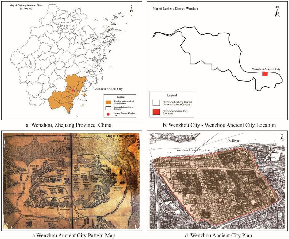
Figure 1. Research seope of ancient Wenzhou City. (a) for wenzhou, zhejiang Province, China. (b) for Wenzhou City-wenzhou ancient city location. (c) for Wenzhou ancient city pattern map. (d) for Wenzhou ancient city plan. (Image source: drawn by the author).
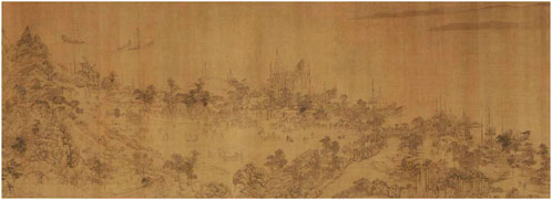
Figure 2. The prosperity of Shuo Gate Ancient Port in Wenzhou during the Yuan Dynasty (A.D. 1271–1368) (Image source: Scenery of Rivers and Mountains by Wang Zhenpeng of the Yuan Dynasty).
The geographical location of the ancient city also makes it the administrative, economic, and cultural center of southern Zhejiang. Ancient Wenzhou City, the seat of Wenzhou Prefecture, concentrates important administrative agencies and commercial districts, attracting many people and resources. Ancient Wenzhou City occupies an important position in the historical development of China’s southeast coast, with excellent natural conditions and a convenient transportation network. It has become an ancient water town with profound historical and cultural heritages.
2.2 Research process
This study illustrates the layout of ancient Wenzhou City during four historical periods: the 45th year of the Jiajing reign of the Ming Dynasty (1566 AD), the 30th year of the Qianlong reign of the Qing Dynasty (1765 AD), the second year of the Guangxu reign of the Qing Dynasty (1876 AD), and the founding year of the People’s Republic of China (1949 AD). The illustration process involves eight steps, including base map preparation and analysis, setting reference points and scales, and image correction and calibration. Second, the spatial syntax tool was used to analyze the axial structure relationship between the water network and the streets and alleys in the four different periods in terms of integration, selectivity, and understanding. Finally, the development law of the ancient city function and space was studied through the evolution of the functional attributes of the ancient city building land in the four periods (Figure 3).
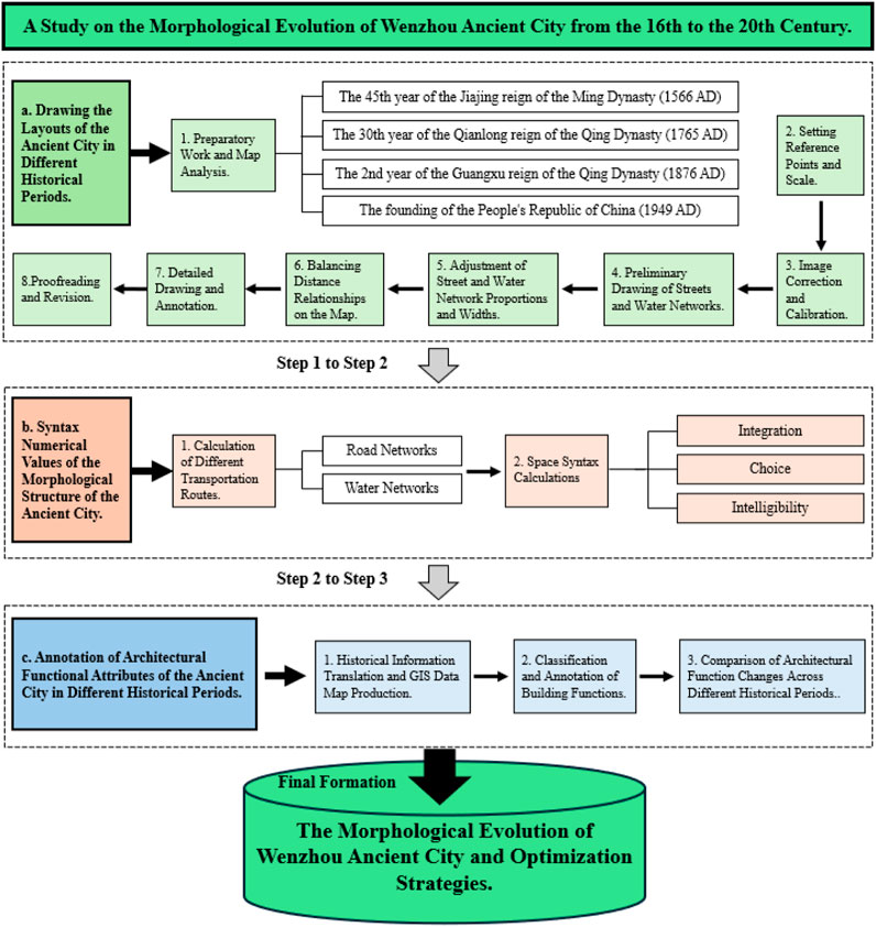
Figure 3. Research Framework (Image source: drawn by the author).
2.2.1 Drawing the layouts of the ancient city in different historical periods
This study examined ancient maps from four periods: the 45th year of Jiajing in the Ming Dynasty (1566), the 30th year of Qianlong in the Qing Dynasty (1765), the second year of Guangxu in the Qing Dynasty (1876), the founding year of New China and the liberation of Wenzhou (1949). We ensured a reasonable balance of distance relationships on the map by engaging in the following steps.
(1) Preparation and map analysis. The four images are imported into CAD software. A high-resolution map is used to clearly identify map details, especially core features such as streets, water networks, and city walls. Each map is carefully analyzed, and its main elements—including natural and artificial features such as city walls, city gates, streets, water networks, and mountains—are identified. Because these ancient maps may differ in their drawing methods, scales, and styles, adjustments are needed.
(2) Reference point and scale setting. To ensure accurate splicing, each map requires the determination of a reference point. The reference point can be a feature point, such as a city gate, a river intersection, a mountain, or a corner of a city wall. Several reference points are selected to ensure accuracy. To determine the scale of each map, the actual lengths of several major streets or city walls are selected on the basis of known, modern surveying and mapping data or historical records. The scale is key to ensuring reasonable proportions of streets and water networks when drawing.
(3) Image correction and calibration. To ensure the spatial accuracy of the historical maps (i.e., cross-validation), the correction process combines the length of the city wall recorded in Wenzhou Prefecture records with modern surveying and mapping data (such as OpenStreetMap). Because map styles differ (such as the freehand style of Ming Dynasty maps and the measured style of Qing Dynasty maps), a local-scale adjustment strategy is adopted to align static landmarks such as city walls, city gates, and main rivers.
(4) Streets and water networks initial sketching. The polyline tool in CAD is used to draw the center line according to the street direction shown on the ancient map. Because the ancient maps lack clear street width information, we initially drew only the street direction. Similarly, we drew the water network using the polyline tool, following the direction of the river, lake, or channel. The direction of the main water bodies and tributaries should be consistent with the map, and attention should be given to water network and street intersections.
(5) Street and water network scaling and widening. We compare the widths of specific streets, lanes, li, fang, alleys, temples, mansions, and water town canals with modern urban water networks, streets, and lanes to estimate the width of different road axes using historical data (e.g., the chapter on city construction in Wenzhou Prefecture Records, the chapter on city states in the chapter on building methods, and the chapter on canals in Zhejiang Waterway Records).
(6) Distance relationship balancing. During the drawing process, attention is given to possible scale distortions on the ancient map, particularly with regard to street length and the water network direction. Modern surveying and mapping data are referenced to appropriately stretch or compress specific areas in the map and ensure that the distance between the main features meets modern measurement standards. While adjusting the scale and distance, preserving the historical authenticity of the ancient map to the greatest extent possible is crucial. For example, in distorted areas, we can adjust the scale locally without compromising the overall structure.
(7) Detail drawing and annotation. Once we completed the preliminary drawing, we detailed the street intersections and optimized the river branches and intersections. In complex water networks, we incorporated additional details such as dams, bridges, and other elements, considering the three-dimensional interlacing relationships among the river network, roads, and city walls. The text tool in CAD was used to annotate the map with details such as street, building, and city gate names. The goal is to maintain the annotation style of the original map and to give attention to the accuracy of the relative positions.
(8) Proofreading and correction. Modern cities’ geographical road network information (OpenStreet Map) is compared with the drawn maps to determine whether the streets, water networks, buildings, etc., are consistent with modern maps. The necessary adjustments to the actual situation are made to ensure that the proportions of all the elements are reasonable and consistent with the historical background. When processing different maps, their boundary alignment, especially the extensions of streets and water networks, is checked. The docking of maps through benchmarks is adjusted to ensure no obvious misalignment among the maps. A comparison of street and lane names as well as their spatial relationships as recorded in the local records from the different periods (such as the Yongjia County Chronicles), allows for the correction of local distortions caused by differences in map projections. For example, the relative positions of Haitan and Songtai Mountains in the 1566 map were recalibrated using site coordinates from the archaeological report.
2.2.2 Syntactic numerical values of the morphological structure of the ancient city
Space syntax is a quantitative tool for analyzing urban spatial structures and functional layouts. Calculating indicators such as integration and selectivity reveals the connectivity and centrality of an urban internal space (Pan et al., 2022). These indicators directly reflect the urban planning structure and development focus of the ancient city at different stages. In the study of the morphology of the ancient city of Wenzhou, space syntax helps analyze the roles of road and water networks in different historical periods and reveals the evolution of urban functions and spatial structures (Dai et al., 2022; Zhu and Liu, 2023). Because it quantitatively evaluates the accessibility and connectivity of functional areas, space syntax provides an important scientific basis for understanding the spatial organization, functional zoning, and evolution of the ancient city of Wenzhou. Space syntax also provides guidance for modern planning and the protection of ancient cities, ensuring a balance between historical and modern needs (Table 1).
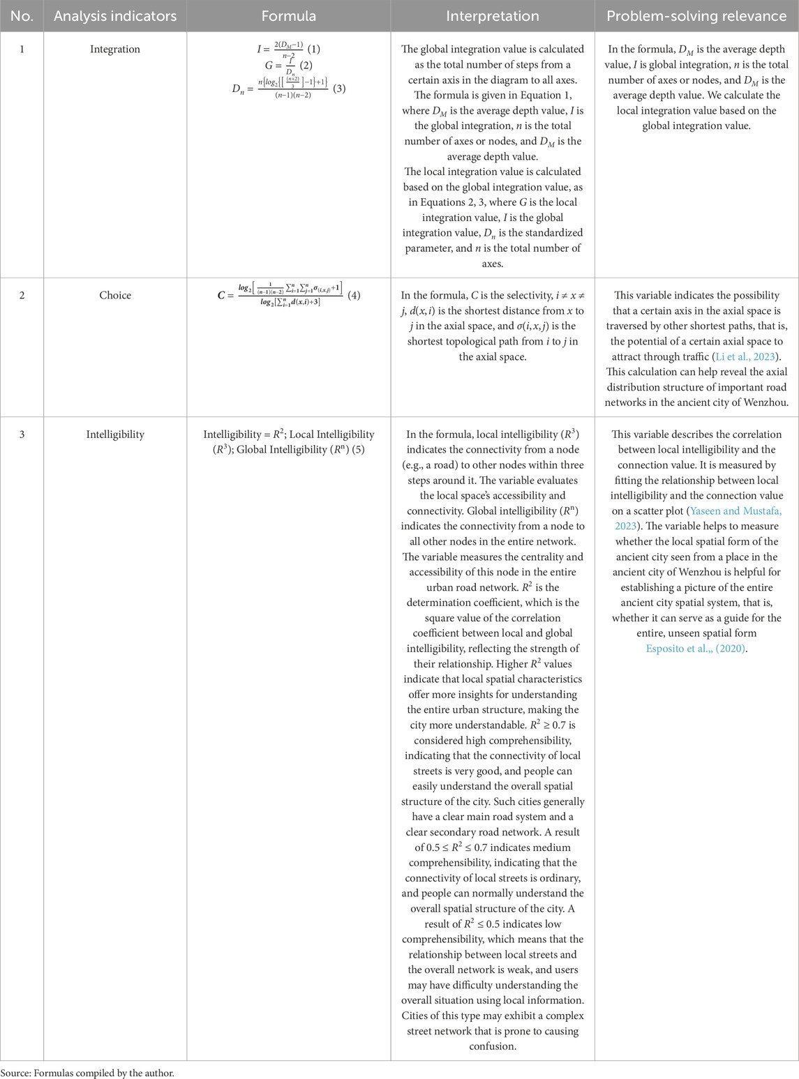
Table 1. Analysis indicators, formulas, interpretations and problem-solving relevance.
2.2.3 Labeling the functional attributes of ancient city buildings in various periods
(1) Using local records such as the Yongjia County Chronicles (永嘉县志) and historical maps provided by the Wenzhou Archives, we obtained information on the functional layout of buildings in different periods in the ancient city of Wenzhou. The researchers digitized the historical maps using GIS tools and constructed digital models of the functional areas of buildings in different periods.
(2) The researchers then classified and divided the building functions into administrative, military, commercial, residential, industrial, and agricultural. We marked each period’s functional area range on the basis of its functional evolution (Zhou et al., 2022).
(3) Finally, we analyzed the evolution of building functions over time by comparing their labels at various points in time. We focused on how commercial, residential, handicraft, and administrative areas as well as water networks have changed, showing how urban functional differentiation and diversification have occurred over time (Li and Gong, 2022).
2.3 Data sources
The data sources for this study are as follows: (1) Ancient city map information data were used. The researchers collected and analyzed historical documents and local records related to ancient Wenzhou City from the 16th to the 20th centuries. Such documents included Wenzhou Prefecture Chronicles (温州府志), Yongjia County Chronicles (永嘉县志), and Wenzhou Scenic Spots and Historic Sites Chronicles (温州名胜古迹志). These documents and maps provided information on the changes in the ancient city’s layout, block structure, river channels, water systems, city walls, etc., in different historical periods. (2) Data on the nature of the land use in the ancient city were also secured. The researchers applied for a 3.4-square kilometer ancient city land attribute map through the Wenzhou Natural Resources and Planning Bureau (https://zrzyj.wenzhou.gov.cn/) (viewed on 6 March 2025). (3) Ancient city architectural site node data were used. The researchers referred to the archaeological excavation reports and survey data from cultural relic protection units in the Wenzhou area. These data provided empirical information on the ruins, blocks, and architectural structures of ancient Wenzhou City from the 16th to the 20th centuries (https://oyjy.wzlib.cn/) (viewed on 6 March 2025). (4) An onsite survey and site investigation were made. The researchers used archaeological excavation reports and site survey data from the Wenzhou area, which provided information on the distribution and evolution of physical spaces such as buildings, streets, and city walls within the ancient city.
In the context of the limitations of historical maps, the ancient maps used in this study have problems such as scale distortion and missing details (for example, the minor streets and lanes in the 1876 map are not fully marked). To improve the correction accuracy, the Georeferencing tool of ArcGIS 10.8 was used for control point registration (RMSE <5 m), and the river width data in the Zhejiang Waterway Records was used to compensate for the missing map information. In addition, the relationship between the city wall outline and elevation was verified with LiDAR terrain data to reduce topological errors on the hand-drawn maps.
3 Results: analysis of the evolutionary process and change pattern of the ancient city
3.1 Classifying the morphology of ancient Wenzhou city in different periods
The urban morphology of Wenzhou, an ancient city, underwent unique changes during four distinct periods: the 45th year of Jiajing in the Ming Dynasty (A.D. 1566), the 30th year of Qianlong in the Qing Dynasty (A.D. 1765), the second year of Guangxu in the Qing Dynasty (A.D. 1876), and the founding year of New China (A.D. 1949). These changes reflect the urban development and management methods under different historical backgrounds, as illustrated in Table 2.
(1) Ancient Wenzhou City focused on defense during the early stages of the 45th year of Jiajing in the Ming Dynasty (A.D. 1566). Heavy city walls surrounded the city, resulting in a closed layout. City walls, gates, and other facilities served the city’s defense (see Figure 4A). The central axis strictly guided the development of the street network, whereas the water network supplied the city’s domestic water and served defense functions. The urban management system was highly centralized and focused mainly on military defense and administrative management. During this period, external conflicts were frequent, and the need for defense facilitated the formation of the city’s shape.
(2) During the 30th year of Qianlong in the Qing Dynasty (A.D. 1765), ancient Wenzhou City gradually expanded because society was relatively stable and the economy was prosperous (Figure 4B). This situation led to the formation of the city’s extension, and the prosperity of commercial activities facilitated the development of both water and land transportation systems. The street network inside and outside the city became denser, and the river acted both a domestic water source as well as an important trade and transportation route. The commercial area along the river developed rapidly. At this time, urban management gradually shifted to economic management, local governments adopted the city’s commercial and tax management, and the urban functional areas slowly became clear.
(3) In the second year of Guangxu’s Westernization in the Qing Dynasty (A.D. 1876), Wenzhou entered the early stage of modernization. Influenced by the West, Wenzhou’s urban form began to transform (Figure 4C). The city wall’s defensive function gradually weakened; the streets expanded beyond the city limits; and the role of the water network deteriorated, primarily serving as a drainage system for the city. The Western urban planning concept and the emergence of industry promoted the transformation of Wenzhou’s urban form from traditional to modern. The management approach also gradually introduced modern urban management concepts, which equally emphasize trade and defense.
(4) After the founding of New China (A.D. 1949) (the period of reform and development), the ancient city of Wenzhou entered the initial stage of modernization. The government demolished the city wall, vastly expanded the road network, shifted the focus of urban development to industrialization and infrastructure construction, transformed the water network to serve the purposes of drainage and flood control, clarified the urban functional zoning, and accelerated the pace of urban expansion (Figure 4D). Under the socialist system, the urban management system evolved into collective management and economic construction, and industrialization gained prominence, accelerating Wenzhou’s transition from a traditional to a modern city.
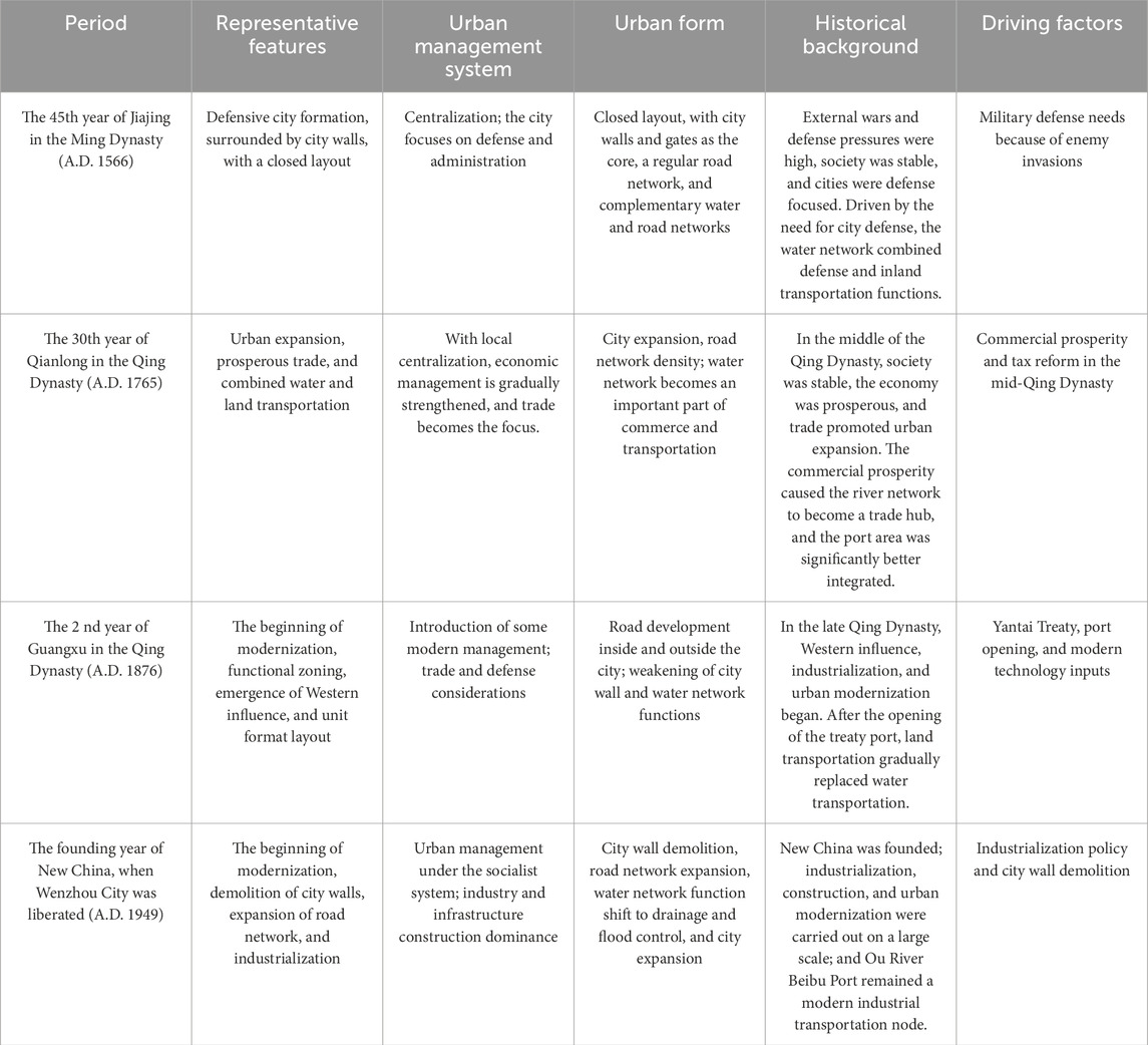
Table 2. Form division of ancient Wenzhou City in the studied periods.
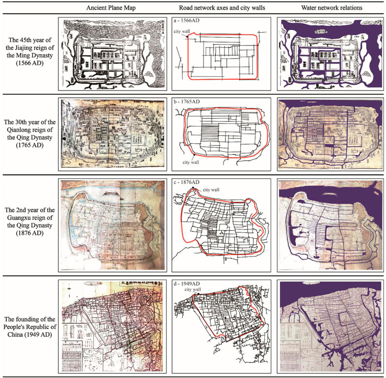
Figure 4. (a) for Maps of ancient Wenzhou City from the 45th year of the Jiajing reign of the Ming Dynasty (A.D. 1566), (b) for the 30th year of the Qianlong reign of the Qing Dynasty (A.D. 1765), (c) for the second year of the Guangxu reign of the Qing Dynasty (A.D. 1876), (d) for and the founding year of the People’s Republic of China(A.D. 1949). Illustrate the relationships among the road network, the city wall, and the water network. (Image source: drawn by the author based on theWenzhou Prefecture Records).
During these four periods, ancient Wenzhou City gradually evolved from a closed defensive city to an open, prosperous, industrialized modern city. The urban management system, economic development, and social background of the period closely influenced the changes in each stage.
3.2 Analysis of the syntactic changes in the ancient city axis in four periods
3.2.1 Integration analysis
Analyzing the changes in the integration of the axis of ancient Wenzhou City across different periods involves exploring the impact of the road and water network integration, their evolution in the urban form, and the integration relationships formed between important urban nodes. An analysis of the road and water network integration of ancient Wenzhou City in different historical periods can reveal the changes in its urban spatial structure and urban functions, social and economic activities, and transportation network layout. The following is a detailed analysis of the four periods of the 45th year of Jiajing in the Ming Dynasty (A.D. 1566), the 30th year of Qianlong in the Qing Dynasty (A.D. 1765), the second year of Guangxu in the Qing Dynasty (A.D. 1876), and the founding year of New China (A.D. 1949).
3.2.1.1 The 45th year of Jiajing in the Ming Dynasty (A.D. 1566): a period of low integration with closed defense as the main feature
During Jiajing’s 45th year in the Ming Dynasty (A.D. 1566), ancient Wenzhou City’s road network integration was relatively low, with the lowest value of 0.333, the highest value of 3.542, and an average integration value of 1.612 (Figure 5A). During this period, the road network layout prioritized defense. The city’s transportation system was relatively simple and focused primarily on the city’s central axis. The main roads primarily served as connections between the city gates and administrative centers such as the government office. The nodes with higher integration (red and yellow areas) were the north‒south main roads and their intersections. These roads served defensive and administrative functions. The city’s secondary roads and alleys were generally not well integrated, and the internal connections were relatively loose, reflecting the city’s defense-centered function.
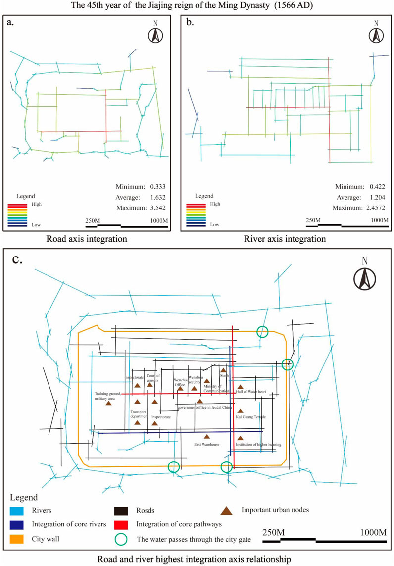
Figure 5. For the 45th year of Jiajing during the Ming Dynasty (A.D. 1566), the roads, the rivers, and their integrations are compared. (a) for Road axis integration, (b) for River axis integration, (c) for Road and river highest integration axis relationship.(Image source: drawn by the author).
The water network was slightly more integrated than the road network was, with the lowest value of 0.422, the highest value of 2.577, and an average value of 1.204 (Figure 5B). Specifically, the main river was better integrated with the moat. The water network not only fulfills the functions of water transportation and drainage within the city but also constitutes the main waterway transportation mode between the city and the surrounding areas. The city closely connected its river channels. During this period, the water network was both a means of transportation within the city and a necessary facility to ensure an effective urban defense.
During this period, the relationships between the road and water networks were relatively close. The city’s core nodes, such as the city gates and government offices, formed close connections with highly integrated rivers and roads, ensuring smooth connections between internal defenses and external connections. The core integration nodes were situated in close proximity to the government offices (Wenzhou Office, Wenzhou Security, Haichengsi, etc.) (Figure 5C), city gates (north and south city gates as well as water and land ports), and moats. The government office was the heart of urban power, and city gates were the city’s primary import and export roads. The main roads, with high integration, connected these nodes to form a basic skeleton. During this period, the layout of the road and water networks reflected the prioritizing of defense. Owing to the threats of war and social unrest, the city focused on ensuring internal security. The road network primarily served defense dispatch functions, whereas the water network had living, drainage, and defense functions. This closed urban layout restricted the efficient integration of internal transportation and limited the spatial expansion of commercial activities.
3.2.1.2 The 30th year of Emperor Qianlong of the Qing Dynasty (A.D. 1765): the prosperity of commerce and the improvement of the transportation network
By the 30th year of Qianlong’s reign in the Qing Dynasty (A.D. 1765), the degree of road network integration in ancient Wenzhou City had significantly improved. The lowest degree of integration was still 0.333, but the highest value reached 3.317, and the average degree of integration increased to 1.506 (Figure 6A). As the city expanded, the complexity and connectivity of the road network increased significantly, especially the integration of neighborhoods and business districts along the river. After the city expanded, the connections inside and outside the city became closer, and the main roads were better integrated, especially the main streets in the north‒south direction and the commercial blocks distributed along the river. These highly integrated nodes connected the main city gates and markets, serving the prosperous commercial activities at that time. Additionally, the secondary arterial roads were better integrated, fostering closer connections between commercial and residential areas.
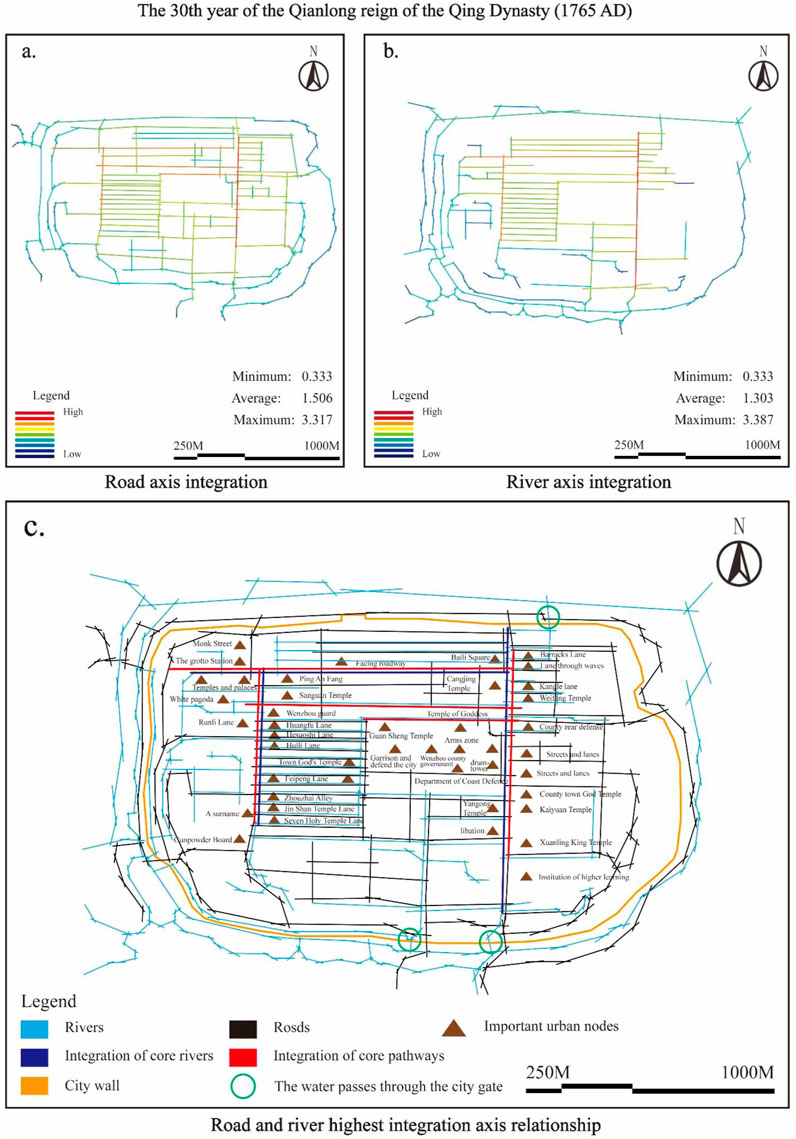
Figure 6. For the 30th year of Qianlong’s reign in the Qing Dynasty (A.D. 1765), a comparison was made between roads, rivers, and their integration. (a) for Road axis integration, (b) for River axis integration, (c) for Road and river highest integration axis relationship. (Image source: drawn by the author).
The integration of the water network kept pace with that of the road network, with the lowest value being 0.333, the highest value being 3.387, and the average degree of integration being 1.303 (Figure 6B). The canals and inland river systems were highly integrated, especially in areas with intensive commercial activities along the rivers. The main river and canal systems were highly integrated, creating close connections with the business districts along the rivers. The river network in the city connected the main markets. By incorporating freight points, the water network’s transportation function was further enhanced.
The road water networks tended to integrate to a balanced degree. The road network played an important role in urban expansion and commercial activities, while the water network remained an important freight channel. The city’s economic development benefitted from the road and water networks’ close integration. The integration of rivers and streets jointly promoted the prosperity of the urban economy. The Qing Dynasty (A.D. 1644–1911) concentrated the core integration nodes of the city gates, markets, and neighborhoods with relation to the major rivers. In particular, roads intersecting canals had the highest degree of integration. These nodes acted both as distribution centers for material transportation and centers of commercial activity, forming a highly integrated urban space (Figure 6C). During this period, the road and water networks became more closely integrated. Markets and business districts, the city’s main nodes, formed a tight network with highly integrated roads and rivers, maximizing the commercial and transportation functions.
During this period, the joint improvement in the integration of the road and water networks reflected the strong development needs of Wenzhou’s commercial activities. Wenzhou gradually transformed from a defensive to an open city and gradually optimized its transportation system to enhance trade flow. The road and water networks together formed the basis of the commercial and economic activities, and the urban spatial structure was more open. However, this layout, which relied on the water network, also imposed limitations on the concentration of commercial and residential areas, potentially restricting the diversification of urban functions.
3.2.1.3 The second year of Guangxu in the Qing Dynasty (A.D. 1876): the dominance of the modernization process and road network integration
In the second year of Guangxu in the Qing Dynasty (A.D. 1876), the Qing government signed the Treaty of Yantai with the United Kingdom and opened Wenzhou, Wuhu, Yichang, and Beihai as treaty ports. As a result, Wenzhou experienced a historic turn and truly entered modern society (Figure 7). As the city gradually modernized, the road networks were further integrated. The highest value for the road network axial integration was 3.067, and the average value was 1.327 (Figure 8A). The integration of the road network is evident in the increased densification of the main urban axes and markets along the streets, the gradual expansion of the city, and the enhancement of street grids. Specifically, the city significantly enhanced its external connectivity. Integration on the city’s main north‒south axis was outstanding, and the main roads and branch roads were closer together. Notably, the new roads expanded beyond the city wall, especially near the docks along the Ou River, a trading port in the north of the ancient city. These new roads also radiated changes in the land use pattern for worship, religion, ethnology, administration, market trade, and housing in the north of the city. This situation led to a more complex road network system and improved transportation connections within the city. The expansion of commercial functions led to an increase in road integration, especially for streets connecting markets and important buildings.
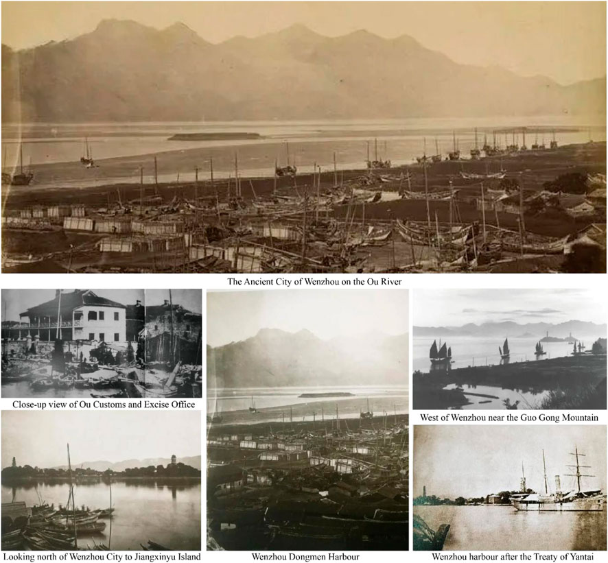
Figure 7. A prosperous scene can be seen at the northern wharf of ancient Wenzhou City, following the opening of the treaty port. (Image source: The author took and compiled the photos based on the Wenzhou Studies archives.)

Figure 8. For the second year of Guangxu in the Qing Dynasty (A.D. 1876), a comparison was made between roads, rivers, and their integration. (a) for Road axis integration, (b) for River axis integration, (c) for Road and river highest integration axis relationship. (Image source: drawn by the author).
The integration of the water network was relatively stable, with the highest level of 3.429 and an average level of 1.203, but its function began to gradually shift to drainage and auxiliary transportation, and the importance of water transportation was slowly replaced by land transportation (e.g., the trading port connected to the Ou River port was isolated from the water network in the city, and land transportation was used instead) (Figure 8B). During this period, the integration relationship between the road and water networks changed. The dominant role of the road network gradually strengthened, and although the water network was still highly integrated in some local areas, its overall role was weakened, especially for some small rivers, which were gradually marginalized. Important urban nodes, such as markets and commercial blocks, gradually ended their dependence on the water network, and the road network became the main mode of internal and external transportation in the city.
The core integration axis gradually shifted from government offices and city gates to commercial areas, markets, and neighborhoods along major rivers. The increased integration of the road network caused these nodes to be more closely connected to the rest of the city, reflecting the further concentration of commercial activities. The road network was significantly better integrated than was the water network. The road network gradually replaced the water network as the primary mode of transportation within and outside the city. The water network was relegated to secondary drainage and environmental functions. The city’s transportation network began to focus on both water and land. The focus shifted to primarily land routes (Figure 8C). The wharf on the north bank of the Oujiang River serves as an example. After the signing of the Treaty of Yantai in 1876 (烟台条约), Wenzhou opened its port for trade, and goods that originally relied on water transportation (such as tea and porcelain) gradually shifted to land transportation. According to the Wenzhou Prefecture Chronicle (温州府志), the annual cargo volume of the Ou River waterway decreased by 42% between 1876 and 1890. During the same period, the funding for the dredging project of the Nantang River in the city decreased from 18% to 5% of municipal expenditures, and the remainder was used for road expansion (Figure 7). Direct evidence of the shift in the function of the water network from transportation to drainage can be found in the Yongjia County Water Conservancy Map of 1905 (永嘉县水利图). Nine of the 12 tributaries that were originally connected to the wharf were filled or converted into underground channels, leaving only three main river channels to serve as flood discharge channels during the rainy season.
The significant improvement in the road network during the Guangxu period of the Qing Dynasty marked the gradual transformation of Wenzhou from a traditional to a modern city. The importance of land transportation gradually surpassed that of water transportation. This trend reflected the introduction of modern technology and the diverse development needs of urban functions. The dominance of the road network strengthened connections within the city and facilitated the expansion of external transportation. However, weakening the water network function may put pressure on the city’s ecological environment and flood control system.
3.2.1.4 New China’s founding year (A.D. 1949): modern urban expansion and thorough road network integration
After the founding of New China, ancient Wenzhou City’s road network integration degree reached a new height, with the highest value being 3.642 and the average value being 1.467 (Figure 9A). The city’s traffic efficiency greatly improved with the integration of the road network, particularly the expansion of the main road system and the density of secondary roads. The integration of urban road networks reached a new level. Urban modernization expanded the road network beyond the original city walls. The main roads, secondary roads, and branch road systems covered the entire city, significantly improving connectivity. The new industrial, commercial, and residential areas had close transportation links, a highly integrated road network, and a strengthened integration of the urban space.
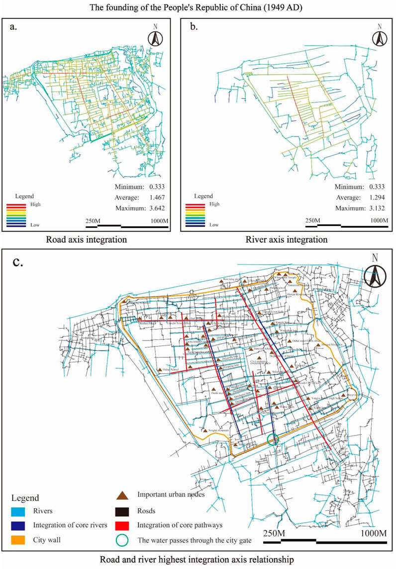
Figure 9. For the founding year of the People’s Republic of China (A.D. 1949), a comparison was made between roads, rivers, and their integration. (a) for Road axis integration, (b) for River axis integration, (c) for Road and river highest integration axis relationship. (Image source: drawn by the author).
The degree of water network integration continued to decline, with a maximum value of 3.132 and an average of only 1.924 (Figure 9B). The water network gradually lost its dominant role in urban transportation and began to serve drainage and environmental functions more. This period marked a significant differentiation in the integration relationship between the road and water networks. The Wenruitang River is taken as an example. According to the 1952 municipal archives, 80% of the river was converted into concrete drainage channels, leaving only the core river section as a water source for landscaping uses. The 1955 Wenzhou Municipal Report noted that the proportion of water transport used for urban freight decreased sharply from 65% in 1940 to 7%, whereas the road freight volume increased by 320% during the same period. The road network became the main transportation system of the city. Highly integrated roads connected important nodes such as industrial areas and commercial centers. The water network played a significant role in this structure. The effect was greatly reduced. The urban transportation system almost completely withdrew from the water network, relegating it to auxiliary functions such as flood control, drainage, and environmental management.
The core integration axes focused on new business districts, industrial areas, and transport hubs. The high degree of integration of the road network closely connected these nodes to the entire urban network, particularly the transportation hubs and commercial centers on the main roads, making them key nodes for urban spatial connections. After 1949, rapid urban expansion and industrialization promoted the comprehensive integration of the road network. The road network not only served the transportation needs within the city but also connected external industrial and residential areas. The weakening of the water network function reflected the high dependence of modern cities on land transportation, and the water network gradually degraded into a drainage system. This transformation introduced an efficient transportation organization to the city, but it also weakened the ecological and environmental functions of the water network in the urban space.
Through the changes in the integration of the road network and water network in the ancient city of Wenzhou during the four periods, we can see the city’s gradual transformation from serving defensive functions to engaging in commerce, industry, and modernization. Early urban road and water networks were closely related, and water networks played an important role in urban defense, transportation, and life. As the urban economy developed, the road network gradually became more integrated, the water network’s dominant position gradually yielded to the road network, and the urban node layout gradually shifted toward openness and diversification. After 1949, modernization and industrialization bolstered the road network’s dominance, while the water network’s function gradually diminished, indicating a shift in urban functions from traditional water transportation to modern land transportation. In this process, the relationship between urban nodes and integration also gradually evolved. From the early defense and administrative centers to the expansion of commercial and industrial areas, changes in the integration of the road and water networks reflect the transformation of urban spatial functions (Figure 9C).
3.2.2 Choice analysis
For the four studied periods, the researchers engaged in a choice analysis. The evolution of the urban form, functional layout, and transportation network significantly changed the selection of ancient Wenzhou City. The choice reflected the frequency with which a certain path served as a connecting node between other paths in the entire urban network. Streets with a high degree of choice are usually gathering points and traffic flow hubs. This study explores the gradual evolution of the road network structure of Wenzhou’s ancient city and analyzes choices in four distinct periods of the ancient city’s axial space, with a focus on the shift in selectivity between the core and the secondary roads.
3.2.2.1 The 45th year of Jiajing in the Ming Dynasty (A.D. 1566)
During this period, ancient Wenzhou City’s selection of the main axes was characterized by a closed road network structure and limited transportation options. The overall structure of the road network in ancient Wenzhou City was relatively simple, with the most selective roads concentrated on the main roads running north‒south and the connecting roads between the east‒west city gates. These main streets (red and orange areas) carried most of the traffic flow within the city and formed the core traffic flow path. Compared with modern cities, the urban layout during the Ming Dynasty (A.D. 1368–1644) was relatively closed, and the selectivity of secondary streets and lanes was relatively low, especially in residential areas and areas with secondary functions within the city, with low selectivity designated as blue and green areas. This layout reflected the city characteristics at that time, which were mainly based on defense functions, and the intelligibility and openness of the transportation network were not high. At this time, the roads with the highest selectivity were responsible for material transportation, administrative management, and defense dispatch within the city. The selectivity data reflected the city’s high degree of centralization and low mobility on peripheral streets.
The north‒south main roads and the east‒west roads connecting the main city gates concentrated the choice of the road network in the ancient city of Wenzhou. The primary traffic flow of the city was served by these highly selective roads, forming a single, core axial traffic mode. Owing to defense needs, the choice of secondary roads was low (Figure 10), traffic mobility was limited to a few key roads, and no choice was made for peripheral streets. The closed nature of the road network resulted in a compact city form, where the city wall served as the boundary, city functions were highly concentrated in the core area, and peripheral development was restricted.
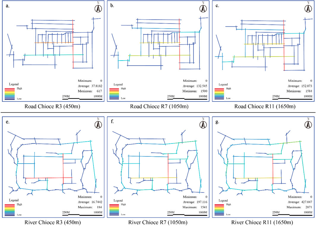
Figure 10. In the 45th year of the Jiajing reign of the Ming Dynasty (A.D. 1566), an analysis was conducted on the choice of road and river networks. Road Chioce (a) for R3(450m), (b) for R7(1050m), (c) for R11(1650m). River Chioce (e) for R3(450m), (f) for R7(1050m), (g) for R11(1650m). (Image source: drawn by the author).
The moat and main rivers inside the city played important roles in urban defense, drainage, and domestic water supply. During this period, the river’s selectivity was high, especially in the moat along the city wall. The river served as a defensive barrier for both internal and external traffic, guaranteed life, and performed a wide range of transportation and flow functions. The high selectivity of the river affected the morphology of the city, causing the expansion of the city to be restricted; the space inside the city was limited, and it was difficult to develop outside the city. Therefore, the urban morphology was relatively closed and defensive (Figure 10).
During the 45th year of the Jiajing reign of the Ming Dynasty (A.D. 1566), the core axis and defensive river channels dominated the road network and river choice, resulting in a closed, single, compact city form. As a result, the city concentrated transportation and urban activities on a limited number of main roads and rivers, restricting the transportation and development of peripheral areas. The city wall bounded the city, defining its compact form and concentrated functions.
3.2.2.2 The 30th year of Emperor Qianlong of the Qing Dynasty (A.D. 1765)
By 1765, the road network choice in the ancient city of Wenzhou had undergone significant changes, which were reflected mainly in the differences in the road network and river selectivity driven by commerce. As cities expand and commercial activities develop, the complexity and connectivity of the road network increase. Figure 11 shows that the selectivity of the north‒south main roads remained high, highlighting the continuity of the urban axis. However, the east‒west road options increased significantly (i.e., the blue and green lines increased), especially in the city center and in busy commercial neighborhoods. The east‒west streets began to carry more traffic. This change reflected the gradual shift in urban form from a closed defensive city to an open commercial city during 1765. The road network gradually diversified, and the connectivity increased. The peak areas of selectivity were concentrated on the main axis but gradually expanded. The choice increase during this period highlighted the city’s increased mobility and accessibility, with traffic no longer concentrated on a few main roads and beginning to disperse to secondary streets and around business districts.
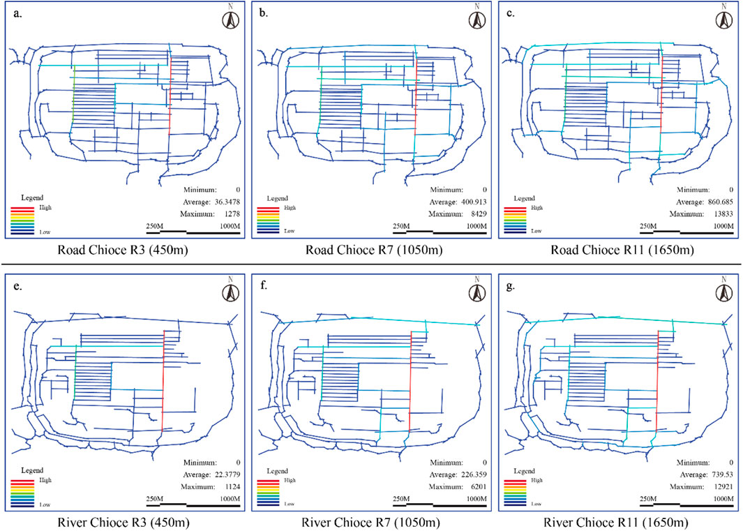
Figure 11. For the 30th year of Emperor Qianlong of the Qing Dynasty (A.D. 1765), an analysis was conducted on the choice of road and river networks. Road Chioce (a) for R3(450m), (b) for R7(1050m), (c) for R11(1650m). River Chioce (e) for R3(450m), (f) for R7(1050m), (g) for R11(1650m). (Image source: drawn by the author).
In 1765, the prosperity of commercial activities resulted in a significant change in the selection of the road network in the ancient city of Wenzhou. The north‒south main roads still had the greatest degree of choice, but the choice of east‒west commercial streets increased significantly, forming a more complex transportation network. The formation of commercial districts and markets promoted traffic flow in the east‒west direction, and the road network gradually expanded from a single north‒south axis to multiple important commercial districts. The choice distribution began to expand outward from the core area, and the urban form changed from a single-core to a multicore structure. During this period, the rivers remained highly selective, especially the commercial areas and freight terminals distributed along the rivers, so the waterways played an important transportation role. Rivers serve as defense and drainage tools and they provide important support for urban commercial activities. As the commercial activities increased, water transportation became one of the driving forces for urban expansion. The choice of river networks increased, which further enhanced the commercial functions of riverside areas, and the city gradually expanded from a single center to spread along the river. In general, the improvements in the road network and river choice led to important changes in the urban form during the Qianlong period of the Qing Dynasty (A.D. 1736–1796). The commercial area expanded along east‒west roads, and the river, as an important channel for transportation and commercial transport, gradually transformed the urban form from a compact defensive structure to an open commercial city. The riverside area became a new center of economic activity, and the city gradually expanded from a single core area to a multicenter structure.
3.2.2.3 The second year of Guangxu in the Qing Dynasty (A.D. 1876)
During this period, modernization, the expansion of road dominance, and the weakening of river functions were largely manifested in the axial selectivity of the ancient city of Wenzhou. The choice of north‒south main roads remained high, demonstrating the continuity of the urban axis. However, the choice of roads increased significantly (i.e., more yellow and red lines), especially in the central and central areas of the city. In busy commercial neighborhoods, east‒west streets began to handle more traffic. This change reflected the gradual shift in urban form from a closed defensive city to an open commercial city that occurred in 1876. The road network underwent gradual diversification, connectivity increased, and the selectivity peak areas were concentrated on the main axes while progressively extending to the commercial and transportation hub regions. The increase in choice during this period reflected the city’s increased mobility and accessibility, with traffic no longer concentrated on a few main roads and beginning to disperse to secondary streets and around business districts (Figure 12).
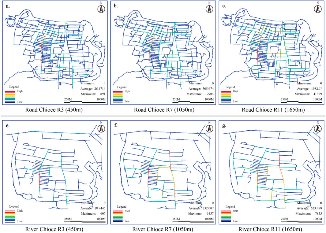
Figure 12. For the second year of Guangxu in the Qing Dynasty (A.D. 1876), an analysis was conducted on the choice of road and river networks. Road Chioce (a) for R3(450 m), (b) for R7(1050 m), (c) for R11(1650 m). River Chioce (e) for R3(450 m), (f) for R7(1050 m), (g) for R11(1650 m). (Image source: drawn by the author).
Thus, the ancient city of Wenzhou further improved the selectivity of its road network, significantly increasing the selectivity of secondary streets within the city, particularly commercial blocks and roads near residential areas that intersect with the main roads. During this period, urban transportation gradually expanded inward and outward, and the road network no longer relied solely on a few main roads. The secondary roads began to bear more traffic. The city’s traffic flow became more balanced, and the enhanced selectivity of the road network encouraged the city to expand outward, resulting in a more open and flexible form. As land transportation became more important, the choice of rivers gradually decreased, more rivers began to serve drainage and environmental functions, and the dominant position of water transportation was progressively replaced by the road network. The reduction in river selectivity restricted city expansion along the river, and land transportation gradually became the main driving force for urban expansion.
In general, during the Guangxu period of the Qing Dynasty (A.D. 1875–1908), the choice of road network increased significantly, especially the choice of secondary streets, which promoted the outward expansion of the city. The city no longer relied on the transportation function of the river, and the reduction in river choice led to a slowdown in the development of the areas around the river. Riverside development gradually gave way to road expansion, revealing a more balanced and decentralized structure; the urban functional areas underwent further refinement; and the direction of the expansion shifted from the rivers to the land.
3.2.2.4 New China’s founding year (A.D. 1949)
The axial choice during New China’s period was characterized by the peak selectivity of the road network, the dominance of the road network under the modern transportation network, and the marginalization of the rivers. With the rapid expansion of the city, the road network structure became more diversified and systematic (Figure 13). The choice of the main roads remained high (shown in the red and yellow areas), but unlike in the past, the choice of the peripheral secondary roads also increased significantly, especially in newly built industrial, residential, and urban expansion areas, where the road network choice had a more balanced distribution. This situation reflected the impact of modern urban expansion, the gradual outward movement of urban functional areas, the transformation of the transportation network from a single-center model to a multicenter model, and the significant improvement in road network connectivity and efficiency. The improvement in selectivity shows that the city’s traffic was no longer concentrated on a few main roads but formed a number of highly selective transportation hubs, the layout of the road network was more balanced, and the traffic flow between the inside and outside of the city was smoother.
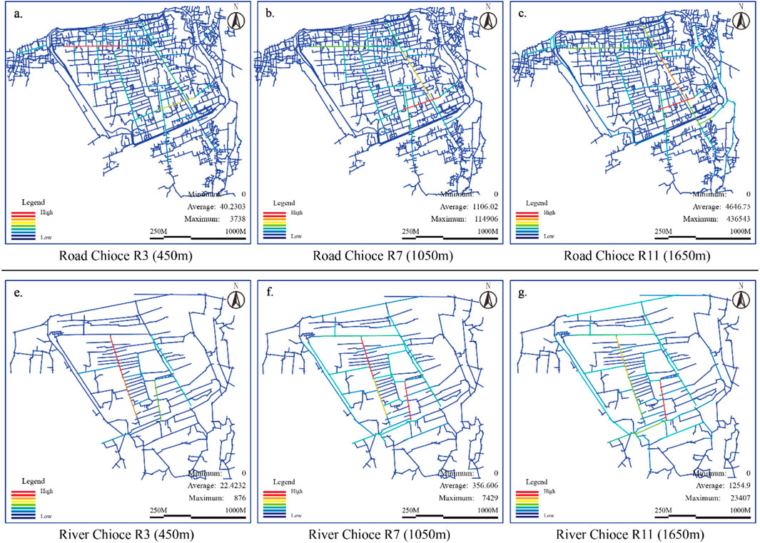
Figure 13. For New China's founding year (A.D. 1949), an analysis was conducted on the choice of road and river networks. Road Chioce (a) for R3(450m), (b) for R7(1050m), (c) for R11(1650m). River Chioce (e) for R3(450m), (f) for R7(1050m), (g) for R11(1650m). (Image source: drawn by the author).
After 1949, ancient Wenzhou City’s road network selectivity reached a historical peak. The road network covered the core area of the city while expanding to the periphery, forming a multicenter, multilevel transportation network (Figure 13). Both the main and the secondary roads had improved choice. The city’s transportation hub was no longer limited to the core area. The roads in the peripheral areas also had a high degree of selectivity, which prompted the city to expand further outward, and the city’s functional zoning became more flexible and diversified. During this period, the rivers’ choice further decreased, leading to their gradual marginalization from the urban transportation network as they primarily adopted the roles of drainage and environmental management. Urban expansion relied heavily on road transportation, while water transportation largely disappeared from the historical context. The decrease in the selectivity of rivers caused the riverside area to no longer be the core area of urban expansion, and urban expansion proceeded more along the main roads and transportation hubs with high selectivity. As a result, after 1949, the road network’s choice increased significantly, and the urban form expanded from a single center to multiple centers. High-selectivity roads connect peripheral areas to the city’s core areas, promoting urban function diversification and spatial expansion. A decrease in river selectivity meant that cities gradually abandoned the transportation modes that relied on rivers. The urban form no longer expanded around rivers but expanded radially outward along the road network, and the form was more open and diversified.
Through the analysis of the changes in the choice of road networks and rivers in the four historical periods, we can see the profound impact of the choice changes on the urban form of the ancient city of Wenzhou. During the 45th year of the Jiajing reign of the Ming Dynasty (A.D. 1566), the city’s choice grew relatively slowly, primarily focusing on the north‒south main roads and the roads connecting to the city gates. These roads served the city’s defense and administrative functions, resulting in a compact and defensive urban form. In the 30th year of the Qianlong reign of the Qing Dynasty (A.D. 1765), as commerce grew, the east‒west road network improved, the city expanded along the river, and its form became more open. Specifically, the preference for east–west commercial blocks grew at the fastest pace, particularly for those blocks near the market and the river. These areas became the center of urban economic activity as commercial activities expanded. In the second year of the Guangxu reign of the Qing Dynasty (A.D. 1876), the improvement in road network choice prompted the expansion of urban functions outward; the river gradually lost its dominant position, and the city expanded from the river to the road network. The number of secondary streets where commercial and residential areas meet increased the most. These areas gradually began to serve as new urban, functional areas through the connection of transportation hubs and trunk roads, promoting the city’s multicenter development. Since the founding of the People’s Republic of China (A.D. 1949), the choice of newly built industrial and residential areas on the periphery has grown fastest. As the city expanded and industrialized, high-selectivity trunk roads closely connected these areas to the city’s core, establishing new transportation and economic function nodes. A multicenter structure dominated urban expansion, the rivers were gradually marginalized, the urban forms became more open and diversified, and functional zoning remained flexible. These changes affected a city’s transportation structure while profoundly changing its functional zoning and expansion direction.
3.2.3 Intelligibility analysis
The change in intelligibility reflected the connectivity and accessibility of the transportation network as well as the importance of different areas in the city as a whole. By analyzing the changes in the intelligibility of ancient Wenzhou City in four historical periods, we can observe the evolutionary trend of the global and local intelligibility of the road network of ancient Wenzhou City, as well as the changes in urban form over time. The intelligibility data of ancient Wenzhou City were divided into four periods.
During the 45th year of the Jiajing reign of the Ming Dynasty (A.D. 1566), the city had a single-center closed transportation network. The intelligence was concentrated on the north‒south axis (road network axis R2 = 0.91, water network axis R2 = 0.68) (Figure 14A), which was consistent with the closed pattern of the “city wall lock key” under the Ming Dynasty’s coastal defense policy. This situation reflected the closed nature of the urban form at that time. City expansion was restricted by the city wall, the functional zoning was relatively concentrated, the development of the peripheral area was suppressed, the traffic mobility depended on a few key roads, and the traffic demand in the peripheral area was low, reflecting a strong defense function.
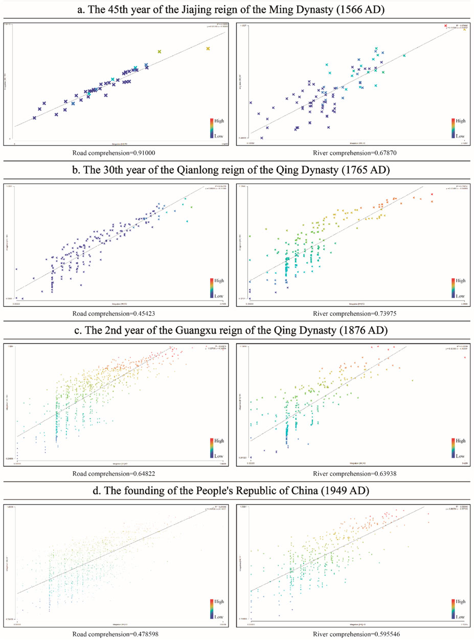
Figure 14. Intelligibility analyses of the roads and water networks of ancient Wenzhou City in four periods. (a) for The 45th year of the Jiajing reign of the Ming Dynasty(1566 A.D.). (b) for The 30th year of the Qianlong reign of the Qing Dynasty(1765 A.D.). (c) for The 2th year of the Guangxu reign of the Qing Dynasty(1876 A.D.). (d) for The founding of the People’s Republic of China(1949 A.D.) (Image source: drawn by the author).
During the 30th year of the Qianlong reign of the Qing Dynasty (A.D. 1765), the east–west commercial network expanded. The intelligibility of the east‒west commercial streets increased (road network axis R2 = 0.45, water network axis R2 = 0.74) (Figure 14B). The long-standing tradition of port trade (ancient Wenzhou City has been an important trading port since the Southern Song Dynasty) and its geographical location (bordering the East China Sea in the east and Fujian in the south) caused ancient Wenzhou City to continue serving as a regional trade hub in the Qing Dynasty, continuing the maritime trade tradition, handicraft foundation and the construction of postal roads centered on the ancient city of Wenzhou. During this period, Wenzhou had 108 shops and 365 soldiers. The main shop in front of the government center was the most important. These conditions provided support for the continual development of the city in the middle of the Qing Dynasty. The east‒west commercial streets and the north‒south main axis together formed the dual-axis structure of the city core, and the urban form developed from a single-center to a multicenter structure. The dual improvements in choice and intelligibility, especially the expansion of the commercial area, promoted traffic mobility, and the commercial and residential functional areas gradually expanded to the periphery, improving the overall connectivity of the city.
During the second year of the Guangxu reign of the Qing Dynasty (1876 AD), the intelligibility of secondary roads increased. The intelligibility of the land transport axes decreased, whereas the intelligibility of the river network axes increased (road network axis R2 = 0.65, water network axis R2 = 0.63) (Figure 14C), and these changes were consistent with the background of the gradual development of land transport in the north after the opening of ports for trade and the gradual decline in river use. The core streets no longer bore all the traffic pressure, and the secondary roads of the city gradually took on more traffic flow. The connectivity of the peripheral areas was improved, which promoted the multicenter development of the city. The urban form expanded from a single core area to a wider area; the functional layout of the city became more balanced; and the core functions gradually expanded outward, forming multiple areas with concentrated traffic flow.
The founding of the People’s Republic of China (A.D. 1949) led to the formation of a multicenter transportation network. The distribution of intelligibility was balanced (road network axis R2 = 0.48, water network axis R2 = 0.60) (Figure 14D), reflecting the formation of a multicenter road network under the industrialization policy. The intelligibility of the main and secondary roads in cities was significantly improved, and the transportation network became more complex and balanced. The city shifted from a single-center to a multicenter structure, traffic mobility increased, the city height expanded, and the structuring and modernization of the transportation network drove the comprehensive development of the city.
In summary, by analyzing the intelligibility data of these four periods, we can see that the urban form of ancient Wenzhou City gradually changed from a closed, single-center structure to an open, complex, multicenter structure (Figure 14).
3.3 Changes and causes of the architecturally functional attributes of the ancient city in different periods
The architecturally functional attributes of ancient Wenzhou City have changed significantly in the studied periods, reflecting the influence of social, economic, political, and other factors. Figure 15 clearly illustrates the evolution of the architecturally functional zoning of ancient Wenzhou City over time, demonstrating a shift from simple to complex areas and from single-function to multifunction areas. Analyzing the changes in architectural functions in the periods reflects the different development needs and trends of the city in terms of defense, commerce, residence, industry, and other aspects. This analysis can help us understand the urban form, functional layout, and development logic behind the changes.
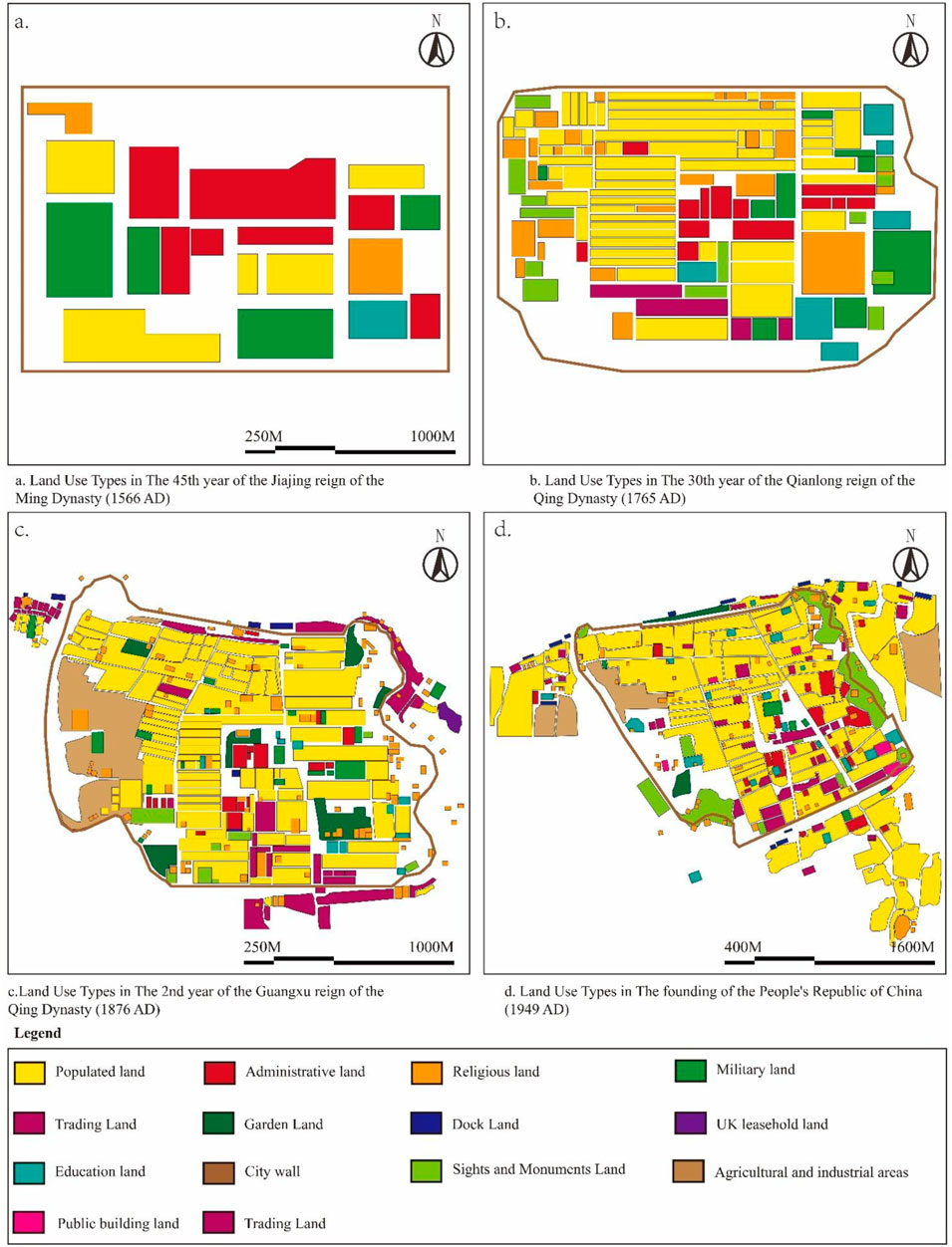
Figure 15. The land use properties of ancient Wenzhou city have changed during the four studied periods. (a) for land use types in The 45th year of the Jiajing reign of the Ming Dynasty(1566 A.D.). (b) for land use types in The 30th year of the Qianlong reign of the Qing Dynasty(1765 A.D.). (c) for land use types in The 2th year of the Guangxu reign of the Qing Dynasty(1875 A.D.). (d) for land use types in The founding of the People’s Republic of China(1949A.D.). (Image source: The author drew this map on the Annals of Yongjia County and data from the Wenzhou Library and Wenzhou Studies Archives.)
3.3.1 The 45th year of jiajing in the Ming Dynasty (A.D. 1566): Defense-dominated single-function layout
During the 45th year of Jiajing in the Ming Dynasty (A.D. 1566), the architectural functions of ancient Wenzhou City were mainly defensive, residential, and administrative, and the city was highly centralized and closed. Defensive structures—such as city walls, moats, military camps, and county garrisons—occupied prominent geographical locations to prevent foreign invasion (Figure 15A). During this period, the compact layout of residential and administrative areas simply reflected the centralized nature of feudal rule.
Residential and administrative areas dominated the land use types, with commercial and handicraft land constituting a relatively small portion of the total. The residential area accounted for approximately 60% of the total land area, reflecting the city’s function at that time, which was mainly based on the lives of its residents. Concentrated in the city’s core, the administrative function area occupied a small proportion of land, but its critical location symbolized the centralization of feudal rule. The allocation of land for building functions in the city reflected the city’s planning concept, which was based on internal self-sufficiency and defense. Defensive walls, moats, etc., occupied a significant part of the city periphery. This type of military defense land occupied approximately 20% of the total land, creating a relatively closed urban form. The commercial area accounted for only a small proportion of the total area, approximately 10%–15%, indicating that commercial activities in Wenzhou City during the Ming Dynasty were relatively limited. The overall urban form presented a compact and defensive monocentric structure. The city wall restricted the city layout, the peripheral land remained undeveloped, the urban function was centered on defense and residence, and the commercial function was relatively weak. During this period, the ancient city of Wenzhou was a typical closed defensive city with a relatively simple form and function.
3.3.2 The 30th year of Emperor Qianlong of the Qing Dynasty (A.D. 1765): commercial functions expand and urban functions gradually differentiate
During the 30th year of Emperor Qianlong of the Qing Dynasty (A.D. 1765), the architectural layout of ancient Wenzhou City began to develop toward multifunctionality, especially with regard to the rapid expansion of commercial functions, which led to significant changes in the urban form. Because commercial activities were prosperous, the east‒west commercial blocks continued to expand, and the proportion of commercial land increased significantly. The distribution of residential and commercial areas gradually became clearer, with commercial and handicraft activities concentrated on both sides of the main traffic arteries, leading to a gradual outward-oriented shift in the city’s economic activities. The main reason for this change was that Wenzhou’s geographical location made it an important regional trade center, and the economic prosperity promoted the diversification of urban functions.
According to the data analysis shown in Figure 15B, the proportion of commercial land increased significantly, reaching approximately 30% of the total urban land area, especially along east‒west streets, which became the central the commercial area. Wenzhou’s status as a commercial city closely correlated with this change. Residential and administrative areas continued to occupy most of the land, accounting for approximately 40% of the total, but the improvements in commercial activities caused the boundaries between the residential and commercial areas to become more distinct. As commercial trade increased, commercial land expanded to various important nodes in the city, especially areas near the ports and east‒west main roads. The expansion of commercial functions indicated that the city’s multifunctionality was gradually increasing. The city was no longer dependent solely on internal functions, and the export-oriented economy gradually became the core driving force of urban development. This period’s urban form gradually evolved from a single defensive function to a multifunctional one. The expansion of commercial areas prompted the development of urban areas from closed to open, forming a multifunctional, commercial axis centered on east‒west streets. The city’s internal functional divisions became clearer, and the urban form gradually diversified, tending to expand outward along the main roads.
3.3.3 The second year of Guangxu in the Qing Dynasty (A.D. 1876): Multifunctional mixed use and the expansion of the urban form
During the second year of Guangxu in the Qing Dynasty (A.D. 1876), the architectural functions of the ancient city of Wenzhou became increasingly complex, resulting in the gradual formation of mixed areas for residential, commercial, and handicraft functions and a more balanced functional zoning of the city. Commercial activities were no longer limited to the main streets but migrated into secondary streets and peripheral areas. The boundaries between residential and commercial areas gradually blurred, more handicraft workshops and small shops appeared in different areas of the city, and urban functions tended to be multicentered. Modernization influenced the changes during this period. The improvement of transportation and the growth of economic activities prompted the city to expand outward, further strengthening the multifunctional mixed urban form.
According to the analysis shown in Figure 15C, the functional zoning of buildings became more complex. The distribution of functions such as residential, commercial, administrative, and handicraft was more balanced. The data show that commercial and residential land each accounted for approximately 35% of the total land area, and the mutual migration of functional areas was relatively obvious. Commercial activities were concentrated on the city’s main roads and extended to its secondary roads. No longer a single, independent, functional area, the residential area then closely connected with the commercial area to form a multifunctional mixed area. The change in the proportion of land use functions during this period reflected the comprehensive enhancement of urban functions. The increase in land for handicrafts and commerce reflected the diversified development of the urban economy. Moreover, as the city expanded, agricultural and defense land around the urban area gradually decreased, the defense function of the city wall weakened, and the city’s boundaries progressively expanded outward. Simultaneously, the opening of the north wharf to the outside world transformed Wenzhou Port into a supply station for maritime freight, serving as the final stop before the East China Sea. Additionally, the British concession stationed in the northeast of the city accelerated the development of the outer city space pattern, leading to the gradual development of the commercial area in the city’s north. As a result, the urban form showed a more obvious trend toward multicenter development. Commercial, residential, handicraft, and administrative areas gradually mixed, forming a more complex urban form. The city expanded more rapidly, the boundaries between the functional areas began to blur, and the city gradually transitioned from a center-based layout model to a multicenter functional layout model. The development of the transportation network promoted the expansion of the urban form. The city no longer confined itself to the exclusive development of its core area. The peripheral areas’ connectivity improved, which promoted the trend of the urban form expanding from the inner to the outer city.
3.3.4 New China’s founding year (A.D. 1949): Industrialization drives urban expansion and diversification of functional zoning
In New China’s founding year (A.D. 1949), the architecturally functional attributes of the ancient city of Wenzhou underwent fundamental changes. The promotion of industrialization made the industrial zone a newly important functional zone, and industrial land quickly expanded to the outskirts of the city. The residential areas also gradually expanded to the city’s edge. The city retained the original commercial and administrative areas while clearly dividing the new industrial and residential functional areas. The promotion of the national industrialization policy caused this change. Industry became the main driving force for urban expansion, and the urban function changed from single commercial and residential to multifunctional coexistence.
As Figure 15D shows, the proportion of industrial land increased significantly, reaching approximately 20% of the total land; residential areas accounted for 40%; and commercial land remained approximately 30%. The expansion of industrial areas promoted the expansion of the city, resulting in a multilevel functional distribution inside and outside the city. The city’s periphery gradually developed into an emerging area that combined industry and residence, and the urban function evolved from a single commercial and residential function to a comprehensive development of industry, commerce, and residence. Urban functional zoning became more diversified and complex, and industrialization became the main driving force for urban expansion. The ratio of industrial to residential areas steadily increased, resulting in a spatial distribution with distinct functions. Moreover, the commercial and administrative functions of the urban core area remained important, but the urban functions began to differentiate, and the peripheral areas gradually assumed more industrial and residential functions. After 1949, the ancient city of Wenzhou took on a typical modern urban form. The city wall no longer restricted the urban form, which was allowed to expand outward. The formation of industrial and new residential areas prompted the city to evolve from a single center to multiple centers. The expansion of the peripheral areas drove the modernization of cities and the diversification of urban functions, and the urban form showed a more complex and multilevel development pattern.
4 Discussion
4.1 The evolution of functional areas under the dynamic development of ancient water towns
The comparison of the spatial syntax axes of the road and water networks of ancient water towns in different periods and the tracking of the evolution of functional areas reveal the stepwise evolution of functional areas in ancient cities. The evolution of functional zoning in ancient Wenzhou City reveals three main themes: (1) the proportion of commerce increased from 15% (1566) to 30% (1765), reflecting the golden age of water transport and trade; (2) after 1876, industrial land (20%) replaced the water network as the engine of expansion, confirming the modernization path of “replacing rivers with roads”; and (3) in 1949, the degree of functional mixing decreased, and industrialization gave rise to a strictly zoned “industry‒city separation” model, which contrasted with the organic form of “front shop and back workshop” found in the traditional water town. Compared with previous studies on the historical water system and modern life of ancient cities (Niu et al., 2021), the morphological pattern of rebuilt ancient cities (Khorloo et al., 2022), and the gentrification of ancient cities and villages (Gocer et al., 2021), this study focuses more on the systematic morphological research framework built from historical development and axial space and patch land attributes. It provides a multidimensional perspective on the study of ancient urban forms.
4.2 Case comparison and implications for ancient city protection
The water network structure of the ancient city of Wenzhou occupied an important position in the Ming and Qing Dynasties, forming a skeleton for urban transportation and economic development. Like other ancient water towns (Feng, Yin and Chen, 2024), Wenzhou relied on the water network system to form a commercial trade model dominated by water transportation. This study, which draws on special case studies, revealed a close relationship between the high integration of the water network and the concentration of commercial functions. The water network acts both as an important channel for material circulation and as a link between the functional areas within the ancient city. However, as the modern transportation network changed, the water network gradually became less integrated, and the road network replaced it as the main organizational method for urban functional zoning.
Similar to other studies on ancient water towns (Wang and Nolf, 2020), this study found that the spatial structural evolution of ancient Wenzhou City transformed from a defensive to an economic function. This study further clearly divided different periods and generated digital spatial maps, deepening the study’s periodicity and the spatial axis distribution data lines. During the 45th year of the Jiajing reign of the Ming Dynasty (A.D. 1566), the spatial layout of ancient Wenzhou City was primarily defensive, with relatively simple functional zoning within the city wall, which restricted the development of the external area. In the 30th year of the Qianlong reign of the Qing Dynasty (A.D. 1765), the commercial function expanded significantly, and the functional zoning of ancient Wenzhou City gradually diversified, reflecting the spatial expansion pattern of the ancient water town during an economically prosperous period. This phenomenon has also been verified in other ancient water towns. For example, Suzhou and Shaoxing’s urban expansion also relied on the prosperity of water transportation and trade (Lv, Wang and Huang, 2023), which promoted the extension of urban space and functional differentiation (Niu et al., 2021).
Compared with the water networks in other Jiangnan water towns—such as Suzhou (Wang et al., 2021), Shaoxing (Xia, 2024), and the Taihu Basin (Wang et al., 2023)—the water network of ancient Wenzhou City declined earlier (1876 vs Suzhou in the 1950s), mainly because the opening of ports for trade accelerated land substitution. This finding supports Kondolf’s and Pinto (2017) hypothesis that “transportation technology iteration leads to water town transformation” (Kondolf and Pinto, 2017) but challenges Zhang’s (2024a) conclusion that “cultural inertia delays the decline of water networks” (Zhang et al., 2024b), indicating that coastal trade cities are more functionally flexible. This study further proposed the concept of the “water‒land function separation threshold”: when the road choice exceeds the water network by 1.5 times (such as in Wenzhou in 1949), the water town form irreversibly transforms into a land-based multicore structure, which has implications for the protection of similar ancient cities.
4.3 The traffic network structure in different periods impacts ancient Wenzhou city’s form
Ancient Wenzhou City’s transportation networks in different periods directly impacted the urban form. The integration of road and water networks changed both the connectivity within the city and the spatial distribution of the urban functional areas. Especially after the People’s Republic of China was founded (A.D. 1949) and the industrialization acceleration, the road network became significantly more integrated, and the expansion of the industrial and new residential areas accelerated the outward development of the city. This expansion model from the inside out is more common in the ancient water towns in the southern region of the Yangtze River, reflecting the transformation of the cities from a closed spatial structure that relies on water networks to an open multicenter structure that relies on road networks.
4.4 Thoughts and strategies for protecting the authenticity of ancient Wenzhou city
In the realm of urban heritage protection, safeguarding the authenticity of spatial form encompasses both the preservation of physical space as well as the reconstruction and regeneration of cultural, functional, and historical continuity. As a typical traditional Chinese water town urban form, ancient Wenzhou City’s spatial form protection should prioritize the continuity of functions and the authenticity of the spatial structure, thereby ensuring the long-term inheritance of historical and cultural values. To this end, the protection of ancient Wenzhou City requires four modes of theoretical and practical construction: the water network, the road network, the building function, and the overall urban form.
(1) Preservation and revitalization of functional areas. In the protection of traditional urban heritages, the continuity of functions is an important factor in ensuring urban vitality and cultural heritage. The layout of various functional areas in ancient Wenzhou City—such as commercial, residential, administrative, and handicraft areas—reflects the city’s development in different periods. As a result, authenticity protection includes both preserving physical space boundaries as well as restoring and continuing functions. We can revitalize historical functions within the framework of modern economic and social needs by regenerating and renewing the original functional areas. For example, the protection of historical, commercial, functional areas such as the East and South Markets should ensure their functional continuity in contemporary urban life by reactivating traditional business models and commercial activities as well as by combining them with modern business formats. This kind of authenticity protection of functional areas maintains the integrity of the city’s historical and cultural context while injecting economic vitality into the ancient city.
(2) Ecological restoration of the water network system and preservation of its features. The water network is an important component of the unique spatial structure and functional attributes of the ancient city of Wenzhou. In the historical development of ancient cities, the water network acts as the basis for urban transportation and commerce while carrying rich ecological and cultural significance. Therefore, to preserve and maintain authenticity, the protection of the water network system should prioritize ecological and functional restoration. Specifically, the restoration of the water network includes the cleaning and redredging of the river channel as well as the restoration of the riverbank ecology and the protection of the historical features of the buildings along the river. By restoring water transportation and creating public spaces along the river, we can strengthen the water network, which plays a crucial role in the transportation and ecological systems of the ancient city, thereby reflecting the contemporary continuation of their historical functions (Figure 16). Ecological and cultural intelligibility can form a dynamic protection system in which the water network of the ancient city exists as both a historical relic and an organic part of modern urban life.
(3) Historical connectivity and spatial integration of the road network. The road network acts as a skeleton for the urban structure. During its historical evolution, the ancient city of Wenzhou had a road network that developed the unique characteristics of high integration and selectivity. In particular, the historical connectivity of the main and secondary streets is an important factor in ensuring the close connection between the urban transportation network and social functions. Therefore, in the process of modern urban transformation and development, the authenticity protection of the road network must prioritize its historical connectivity. Large-scale road widening and linear transformation should be avoided to safeguard this connectivity. In particular, interventions in core blocks and on highly selective roads must be cautious to maintain their historical direction and spatial relationships. Simultaneously, by constructing an external rapid transportation system or an underground transportation network, we can alleviate the internal traffic pressure of the ancient city and safeguard the historical road network from the harm caused by modern transportation demands. This road network protection strategy, with “historical connectivity” at its core, can adapt to the needs of modern transportation development while maintaining the authenticity of the ancient city road network.
(4) Building function renewal and historical feature protection. The protection of the authenticity of building functions involves the dual maintenance of the building’s functional use and spatial value. Historical buildings in ancient Wenzhou acted both as carriers of cultural heritage and core elements of the city’s functional layout. Therefore, we must simultaneously renew building functions and protect their style, ensuring both the historicity of the building’s exterior and the modern adaptability of its internal functions. For example, the protection of traditional shops and residential buildings should focus on the authenticity of materials and craftsmanship while ensuring their applicability in contemporary life by modernizing internal functions. We should combine the functional renewal of buildings with modern commercial and residential needs, especially in the core historical blocks, to prevent damage to the original style. By simultaneously updating the building functions and protecting their historical style, the buildings in the ancient city can maintain their original cultural value while integrating into the modern urban lifestyle, resulting in a cultural and functional win‒win.
(5) Spatial expansion of urban areas coordinated with historical land use attributes. The protection of the land use attributes of ancient Wenzhou City involves maintaining the internal, functional areas of the ancient city and requires spatial coordination with modern expansion outside the city. In the process of urban expansion, it is crucial to protect the functional coordination and spatial transition between the ancient city and the new urban area. We should establish functional transition areas, such as cultural and creative industry areas or low-density commercial areas, to mitigate functional conflicts between ancient and modern cities while preserving their cultural continuity. Moreover, building height restrictions and style control are necessary strategies to avoid the visual interference of modern high-rise buildings on the historical landscape of ancient cities. The transition design of functional areas can effectively balance the historical and cultural value of the ancient city with the development of modern cities, preventing the ancient city from marginalization during the modernization process.
(6) Authenticity protection. This mandate can be achieved through public participation and legal protection measures. These measures play crucial roles in safeguarding the land use attributes of ancient Wenzhou City, ensuring long-term protection. Local governments should protect the land use attributes and functional zoning of ancient cities through legislation; clarify the protection standards of buildings, roads, and water networks; and prevent overdevelopment and improper use. Moreover, public participation is an important force for promoting protection work. Community participation and public education should enhance residents’ awareness of and enthusiasm for ancient city protection. Through digital technology and virtual simulation, a digital archive and cultural display platform can be established for the ancient city, which can both enhance public awareness of protection and provide a strong scientific basis for the protection of the ancient city.

Figure 16. Ancient Wenzhou City Water Network. (Image source: provided by Wenzhou Library, Wenzhou Studies Institute, drawn by the author based on the content).
5 Conclusion
5.1 Research findings
This study uses space syntax to analyze the morphological evolution of ancient Wenzhou City in four periods: the 45th year of the Jiajing reign of the Ming Dynasty (A.D. 1566), the 30th year of the Qianlong reign of the Qing Dynasty (A.D. 1765), the second year of the Guangxu reign of the Qing Dynasty (A.D. 1876), and the founding year of the People’s Republic of China (A.D. 1949). We analyze the morphological changes in the ancient city and the changes in the functional attributes of the buildings in different historical periods, drawing important conclusions.
(1) The morphological evolution of ancient Wenzhou City has gradually changed from a monocentric, closed urban structure to a polycentric, open urban structure. This change reflects the transformation of urban functions from defensive to economic and multifunctional. As the social economy developed, especially during the Qianlong period of the Qing Dynasty, commercial functions expanded rapidly, which promoted the extension of the city’s axis and formed a relatively balanced functional distribution.
(2) As a typical Jiangnan water town, the evolution of the historical form of ancient Wenzhou City reflects the development process of traditional Chinese cities and reveals a unique spatial structure, various socioeconomic functions, and a profound connection among the natural environments of the water town. Through a spatial syntactic analysis, this study reveals the morphological changes in the water town of ancient Wenzhou City during different periods as well as the driving factors behind these changes.
(3) The architecturally functional attributes of ancient Wenzhou City have evolved from a defensive function to coexisting commercial, residential, industrial and other functional uses. The industrialization process drove the development of the city’s peripheral areas. The expansion of the industrial and residential areas changed the city’s spatial structure while promoting modernization and multilevel development. These analyses reveal that functional zoning influences the evolution of urban form and closely links it to the expansion of the transportation network as well as shifts in the socioeconomic structure. These results provide an important theoretical basis for the future protection and development of ancient Wenzhou City.
5.2 Limitations
Although this study explored the historical evolution of the morphology of the ancient city of Wenzhou in detail through space syntax analysis, several limitations remain. First, time and space factors may affect the accuracy and completeness of historical maps and local records, leading to acquisition data bias. For example, the details of urban expansion and functional distribution in different periods may be missing or too briefly explained in the literature, thus affecting the spatial morphology analysis.
Second, although space syntax, as an analytical tool, can effectively reveal the structural characteristics and connectivity of urban space, its explanatory power may be limited when faced with complex historical urban systems. In Wenzhou, an ancient city with a rich water system and diverse urban functions, the water and road networks have an intricate interplay. While spatial syntax primarily analyzes the structure of the road network, it has deficiencies in revealing the role of the water network, potentially leading to an inadequate understanding of the overall urban space. Although this study contributes to the understanding of the evolution of the functional attributes of ancient city buildings, a complex, theoretical, system study on the dynamic causes of the morphological changes in ancient cities and the gravity of social networks is still lacking. Furthermore, future research should explore more cutting-edge GIS analysis capabilities, such as spatial interpolation and network analyses, to gain a more detailed understanding of urban growth and the interactions between transportation and the urban form.
Finally, although the technical means and analytical methods used in this study reveal the dynamic evolution of the spatial structure of the ancient city of Wenzhou, they lack the ability to predict future morphological changes. This study does not delve into the future development trend of the ancient city of Wenzhou in the current context of rapid urbanization. Future research should focus on how to protect the ancient city’s historical heritage while meeting modernization needs. Future research could incorporate machine learning in conjunction with model prediction methods such as convolutional neural networks or GWR grid land use to examine the development trend of ancient city morphologies.
Data availability statement
The original contributions presented in the study are included in the article/supplementary material, further inquiries can be directed to the corresponding authors.
Author contributions
YH: Conceptualization, Data curation, Formal Analysis, Funding acquisition, Investigation, Methodology, Project administration, Resources, Software, Supervision, Validation, Visualization, Writing – original draft, Writing – review and editing. ZS: Funding acquisition, Project administration, Writing – review and editing. YC: Formal Analysis, Methodology, Validation, Writing – original draft, Writing – review and editing. KZ: Investigation, Writing – review and editing. ZY: Methodology, Writing – review and editing. LZ: Methodology, Writing – review and editing. SY: Validation, Writing – review and editing.
Funding
The author(s) declare that financial support was received for the research and/or publication of this article. The following funding supports this research: (1) the General Research Project of the Zhejiang Provincial Department of Education: “The Impact of Local Identity on Rural Settlements in the Middle Reaches of the Nanxi River and Optimization Strategies” (Grant Number: Y202353008); (2) the 2024 Zhejiang Provincial Philosophy and Social Science Planning “Provincial–City Cooperation” Project: “The Distribution Characteristics, Spatiotemporal Evolution, and Influencing Factors of Rural Settlements in the Nanxi River Basin from 1990 to 2020” (Grant Number: 24SSHZ085YB). The funders had no role in study conceptualization, data curation, formal analysis, methodology, software, decision to publish, or preparation of the manuscript.
Conflict of interest
The authors declare that the research was conducted in the absence of any commercial or financial relationships that could be construed as a potential conflict of interest.
Generative AI statement
The author(s) declare that no Generative AI was used in the creation of this manuscript.
Publisher’s note
All claims expressed in this article are solely those of the authors and do not necessarily represent those of their affiliated organizations, or those of the publisher, the editors and the reviewers. Any product that may be evaluated in this article, or claim that may be made by its manufacturer, is not guaranteed or endorsed by the publisher.
References
Ancuța, C., and Jucu, I. S. (2023). Sustainable rural development through local cultural heritage capitalization—analyzing the cultural tourism potential in rural Romanian areas: a case study of Hărman Commune of Brașov Region in Romania. Land 12 (7), 1297. doi:10.3390/land12071297
Chen, Q., Fan, J., Zhang, L., and Chen, X. (2018). Paleogeographic evolution of the Lower Yangtze region and the break of the “platform-slope-basin” pattern during the Late Ordovician. Sci. China Earth Sci. 61, 625–636. doi:10.1007/s11430-018-9170-y
Chliaoutakis, A., and Chalkiadakis, G. (2016). Agent-based modeling of ancient societies and their organization structure. Aut. agents multi-agent Syst. 30, 1072–1116. doi:10.1007/s10458-016-9325-9
Dai, X., Jin, J., Chen, Q., and Fang, X. (2022). On physical urban boundaries, urban sprawl, and compactness measurement: a case study of the Wen-Tai Region, China. Land 11 (10), 1637. doi:10.3390/land11101637
Dong, W., Zhang, C., Han, W., and Wang, J. (2024). Localized canal development model based on titled landscapes on the grand canal, Hangzhou section, China. Land 13 (8), 1178. doi:10.3390/land13081178
Esposito, D., Santoro, S., and Camarda, D. (2020). Agent-based analysis of urban spaces using space syntax and spatial cognition approaches: a case study in Bari, Italy. Sustainability 12 (11), 4625. doi:10.3390/su12114625
Farhan, S., Akef, V., and Nasar, Z. (2020). The transformation of the inherited historical urban and architectural characteristics of Al-Najaf’s Old City and possible preservation insights. Front. Archit. Res. 9 (4), 820–836. doi:10.1016/j.foar.2020.07.005
Feng, J., Yin, J., and Chen, Y. (2024). Spatial evolution and influencing factors of water-town settlements in Southern China: evidence from 942 villages in Zhongshan City. J. Asian Archit. Build. Eng., 1–20. doi:10.1080/13467581.2024.2396611
Ferdani, D., Fanini, B., Piccioli, M. C., Carboni, F., and Vigliarolo, P. (2020). 3D reconstruction and validation of historical background for immersive VR applications and games: The case study of the Forum of Augustus in Rome. Journal of Cultural Heritage 43, 129–143.
Gocer, O., Shrestha, P., Boyacioglu, D., Gocer, K., and Karahan, E. (2021). Rural gentrification of the ancient city of Assos (Behramkale) in Turkey. J. rural Stud. 87, 146–159. doi:10.1016/j.jrurstud.2021.09.012
Goswami, A., Sharma, D., Mathuku, H., Gangadharan, S. M. P., Yadav, C. S., Sahu, S. K., et al. (2022). Change detection in remote sensing image data comparing algebraic and machine learning methods. Electronics 11 (3), 431. doi:10.3390/electronics11030431
Gu, C., Hu, L., Zhang, X., Wang, X., and Guo, J. (2011). Climate change and urbanization in the Yangtze River Delta. Habitat Int. 35 (4), 544–552. doi:10.1016/j.habitatint.2011.03.002
Huang, W., Xi, M., Lu, S., and Taghizadeh-Hesary, F. (2021). Rise and fall of the grand canal in the ancient Kaifeng city of China: role of the grand canal and water supply in urban and regional development. Water 13 (14), 1932. doi:10.3390/w13141932
Jinmin, F., and Xiaoxiang, L. (2022). A study of Suzhou as the economic center of China during the Ming and Qing Dynasties. Front. Hist. China 17 (1), 1–36. doi:10.3868/s020-011-022-0001-5
Khorloo, O., Ulambayar, E., and Altantsetseg, E. (2022). Virtual reconstruction of the ancient city of Karakorum. Comput. Animat. Virtual Worlds 33 (3-4), e2087. doi:10.1002/cav.2087
Kondolf, G. M., and Pinto, P. J. (2017). The social connectivity of urban rivers. Geomorphology 277, 182–196. doi:10.1016/j.geomorph.2016.09.028
Lan, T., and Lindqvist, C. (2019). “Paleogenomics: genome-scale analysis of ancient DNA and population and evolutionary genomic inferences,” in Population Genomics: concepts, approaches and applications, 323–360. doi:10.1007/13836_2017_7
Li, J., and Gong, Y. (2022). Spatial location differentiation and development decision optimization of characteristic villages and towns in China. Geogr. Sustain. 3 (1), 21–31. doi:10.1016/j.geosus.2022.01.002
Li, W., Chen, M., Yao, N., Luo, Z., and Jiao, Y. (2023). Spatial-temporal evolution of roadway layout system from a space syntax perspective. Tunn. Undergr. Space Technol. 135, 105038. doi:10.1016/j.tust.2023.105038
Li, X. (2024). Determination of the temporal–spatial distribution patterns of ancient heritage sites in China and their influencing factors via GIS. Herit. Sci. 12 (1), 143. doi:10.1186/s40494-024-01258-6
Lin, S., and Li, Z. (2019). City profile: Wenzhou-A model city of transitional China. Cities 95, 102393. doi:10.1016/j.cities.2019.102393
Luo, X., Yang, J., Sun, W., and He, B. (2021). Suitability of human settlements in mountainous areas from the perspective of ventilation: a case study of the main urban area of Chongqing. J. Clean. Prod. 310, 127467. doi:10.1016/j.jclepro.2021.127467
Lv, W., Wang, N., and Huang, Y. (2023). Study on the sustainability of ancient canal towns on the basis of the topological structure analysis of streets and lanes: a case study of the Xixing ancient town. PLoS one 18 (1), e0279979. doi:10.1371/journal.pone.0279979
Marić, I., Panđa, L., Faričić, J., Šiljeg, A., Domazetović, F., and Marelić, T. (2022). Long-term assessment of spatio-temporal landuse/landcover changes (LUCCs) of Ošljak island (Croatia) using multi-temporal data—invasion of Aleppo Pine. Land 11 (5), 620. doi:10.3390/land11050620
Niu, Y., Mi, X., and Wang, Z. (2021). Vitality evaluation of the waterfront space in the ancient city of Suzhou. Front. Archit. Res. 10 (4), 729–740. doi:10.1016/j.foar.2021.07.001
Pan, M., Shen, Y., Jiang, Q., Zhou, Q., and Li, Y. (2022). Reshaping publicness: research on correlation between public participation and spatial form in urban space based on space syntax—a case study on Nanjing Xinjiekou. Buildings 12 (9), 1492. doi:10.3390/buildings12091492
Pirenne, H. (2014). Medieval cities: their origins and the revival of trade-updated edition. Available online at: https://www.torrossa.com/en/resources/an/5575788 Accessed April 11, 2025).
Porfyriou, H. (2019). Urban heritage conservation of China’s historic water towns and the role of professor Ruan Yisan: Nanxun, Tongli, and Wuzhen. Heritage 2 (3), 2417–2443. doi:10.3390/heritage2030149
Qier, S. A., Yangyang, L., Shan, W., and Wu, S. (2023). Landscape digital gene: on the logic of landscape digitalization—a study of Nanxun ancient town. Zhejiang Prov. China. doi:10.21203/rs.3.rs-3137388/v1
Roberts, P., Carleton, W. C., Amano, N., Findley, D. M., Hamilton, R., Maezumi, S. Y., et al. (2024). Using urban pasts to speak to urban presents in the Anthropocene. Nat. cities 1 (1), 30–41. doi:10.1038/s44284-023-00014-4
Serra, M. L. A., and Pinho, P. (2013). Tackling the structure of very large spatial systems-Space syntax and the analysis of metropolitan form. J. Space Syntax 4 (2).
Shen, J., and Chou, R.-J. (2022). Rural revitalization of Xiamei: the development experiences of integrating tea tourism with ancient village preservation. J. rural Stud. 90, 42–52. doi:10.1016/j.jrurstud.2022.01.006
Terrone, M., Piana, P., Paliaga, G., D’Orazi, M., and Faccini, F. (2021). Coupling historical maps and LiDAR data to identify man-made landforms in urban areas. ISPRS Int. J. Geo-Information 10 (5), 349. doi:10.3390/ijgi10050349
Vythoulka, A., Delegou, E. T., Caradimas, C., and Moropoulou, A. (2021). Protection and revealing of traditional settlements and cultural assets, as a tool for sustainable development: the case of kythera island in Greece. Land 10 (12), 1324. doi:10.3390/land10121324
Wang, Y., Wu, W., and Boelens, L. (2021). City profile: Suzhou, China—the interaction of water and city. Cities 112, 103119. doi:10.1016/j.cities.2021.103119
Wang, Y.-W., and Nolf, C. (2020). “Historic landscape and water heritage of Suzhou beyond the tourist gaze,” in Suzhou in transition (Routledge), 42–86. Available online at: https://www.google.com/books/edition/Suzhou_in_Transition/VBEHEAAAQBAJ?hl=zh-TW (Accessed April 11, 2025)
Wang, Y.-W., Pendlebury, J., and Nolf, C. (2023). The water heritage of China: the polders of Tai Lake Basin as continuing landscape. Plan. Perspect. 38 (5), 949–974. doi:10.1080/02665433.2022.2135131
Xia, Y. (2024). Research on the relationship between ancient commercial culture and modern urban development in Shaoxing water town historical district. Przestrz. Społeczna (Soc. Space) 24 (2), 106–134. Available online at: https://socialspacejournal.eu/menu-script/index.php/ssj/article/view/394 (Accessed April 11, 2025).
Yan, L., Yang, R., Lu, P., Teng, F., Wang, X., Zhang, L., et al. (2021). The spatiotemporal evolution of ancient cities from the late Yangshao to Xia and Shang Dynasties in the central plains, China. Herit. Sci. 9, 124. doi:10.1186/s40494-021-00580-7
Yaseen, F. R., and Mustafa, F. A. (2023). Visibility of nature-connectedness in school buildings: an analytical study using biophilic parameters, space syntax, and space/nature syntax. Ain Shams Eng. J. 14 (5), 101973. doi:10.1016/j.asej.2022.101973
Zhang, J., Tang, X., Yu, Z., Xiong, S., and Yang, F. (2024a). Water-town settlement landscape atlas in the East River Delta, China. Land 13 (2), 149. doi:10.3390/land13020149
Zhang, J., Wang, X., Jiang, L., Chen, Z., Xu, S., and Aoki, N. (2024b). Analysis of the evolution pattern and regional conservation of cultural heritage from the perspective of urban sustainable transformation: the case of xiamen, China. Buildings 14 (3), 565. doi:10.3390/buildings14030565
Zhou, C., Petryshyn, H., Kryvoruchko, O., Kochan, O., and Przystupa, K. (2022). Potential and opportunities of use of postindustrial buildings and territories for urban development: case studies of the historical area in lviv (Ukraine). Sustainability 14 (23), 16020. doi:10.3390/su142316020
Zhu, Q., and Liu, S. (2023). Spatial morphological characteristics and evolution of traditional villages in the mountainous area of Southwest Zhejiang. ISPRS Int. J. Geo-Information 12 (8), 317. doi:10.3390/ijgi12080317
Keywords: traditional water town, morphology, morphological structure, GIS, ancient wenzhou city
Citation: Huang Y, Shi Z, Chen Y, Zhou K, Ying Z, Zheng L and Yang S (2025) Urban form evolution and transformation of traditional water towns based on space syntax and GIS: evidence from ancient Wenzhou city (16th to the 20th century). Front. Earth Sci. 13:1520643. doi: 10.3389/feart.2025.1520643
Received: 31 October 2024; Accepted: 07 April 2025;
Published: 22 April 2025.
Edited by:
Karoly Nemeth, Institute of Earth Physics and Space Science (EPSS), HungaryReviewed by:
Vladyslav Zakharovskyi, Massey University, New ZealandBojana Aleksova, University of Novi Sad, Serbia
Copyright © 2025 Huang, Shi, Chen, Zhou, Ying, Zheng and Yang. This is an open-access article distributed under the terms of the Creative Commons Attribution License (CC BY). The use, distribution or reproduction in other forums is permitted, provided the original author(s) and the copyright owner(s) are credited and that the original publication in this journal is cited, in accordance with accepted academic practice. No use, distribution or reproduction is permitted which does not comply with these terms.
*Correspondence: Zehui Shi, c2hpemVodWlAbmlzdC5lZHUuY24=; Yile Chen, Y2hlbnlpbGVAbXVzdC5lZHUubW8=
†ORCID: Yuhao Huang, orcid.org/0009-0004-8445-5666; Zehui Shi, orcid.org/0009-0003-9141-7134; Yile Chen, orcid.org/0000-0002-8424-8059; Kai Zhou, orcid.org/0009-0003-8688-7844; Ziyi Ying, orcid.org/0009-0000-9026-6969; Liang Zheng, orcid.org/0000-0003-3142-7704; Shuai Yang, orcid.org/0000-0003-4757-9358