 Honglei Lu
 Kunyin Ge*
- Department of Design, College of Art, Anhui University, Hefei, China
Land ecological safety has become a key issue in the pursuit of ethical and sustainable land use. This study, based on the DPSIRM (Driving force–Pressure–State–Impact–Response–Management) framework, employed the entropy weight TOPSIS model and the grey relational analysis model to evaluate the ecological safety level of land resources (ESLR) in North China from 2012 to 2021. The results indicate that overall ESLR has improved, following three distinct phases of stability, substantial growth, and slight decline, while significant regional disparities remain, with Tianjin (0.4495) at a relatively precarious level and Hebei (0.5966) in a more favourable state. Spatial differences are largely shaped by geographical and resource conditions, and among all influencing factors, land resource pressure shows the strongest correlation with ESLR. These findings suggest that although ecological safety of land resources in North China is progressing, uneven regional development highlights the need for targeted strategies to reduce land-use pressures and promote balanced, sustainable land management.
1 Introduction
Early investigation and study of ecological security-related ideas led to the development of the 1949 notion of “land health” by renowned American environmentalist Aldo Leopold (Westing, 1989). The environment and development of the overall land resources is an indispensable part of the human development process, and the limited nature of the land determines that land resources must be rationally utilized. Land is the biological resource and the building block of human existence (Liu et al., 2022; Steffen et al., 2015). The ecosystem service of land resources (ESLR) serves as the foundation for regional eco-civilizations and sustainable development (Wu et al., 2019). However, as industrialization and urbanization have grown since the early 1980s, when Deng Xiaoping’s reform and opening-up policies went into effect, there has been an increase in land conflict (Wu and Zhang, 2012). Much attention has been paid to the problem of how to guarantee that land resources are used continuously while minimizing conflict between people and land (Liu et al., 2020).
Increased land-use intensity is causing the region’s land ecosystems to deteriorate as land use has long outpaced the resources’ ability to sustain ecological loads. Due to the growing population, continuous environmental damage, and other issues, people are confronted with a variety of ecological security concerns pertaining to land resources, such as soil erosion, land pollution, ecological disorders, and other issues (Liu W. et al., 2019). Ecological security and land resource security have steadily emerged as hot topics in global ecological and environmental research, becoming a new focus for the social and economic sustainable growth of humanity as a result of the increasing attention given to ecological issues (Yang et al., 2021). This has also led to research on land conservation, with a progressive shift from passive to active protection (Juanita et al., 2019). An evaluation of North China’s ecological safety with relation to land resources has real-world applications for resolving disputes between people and land, safeguarding the environment, and promoting the cooperative growth of the region.
Ye et al. (2018) proposed that ESLR encompasses both the qualitative and quantitative aspects of provisioning services derived from land ecosystems that are essential to sustaining human survival and development. This concept simultaneously emphasizes the imperative to preserve the structural integrity of land resource ecosystems comprising both organic and inorganic components, ensuring that their fundamental composition remains unimpaired by threats and degradation. Although there is not yet a consensus on what constitutes ecological safeguards for land resources, scholars have come to an agreement regarding its significance and meaning. Scholars further advocate that the ESLR framework must comprehensively incorporate considerations of ecosystems’ dual capacities: to sustainably deliver essential goods and services to human populations while maintaining resilience against pressures arising from shifting land-use patterns and natural perturbations, thereby enabling the formulation of strategic land-use decisions grounded in ecological sustainability principles (Flint et al., 2017; Li and Lang, 2010; Kesgin Atak and Ersoy Tonyaloğlu, 2020).
Moreover, for most indices, there is no recognized threshold value to confirm the amount of arrival. However, the ecological degradation of land resources is becoming a major element impacting the security of the national territory and is endangering the country’s whole ecological security in the wake of the economy’s and society’s rapid advancement (Logan et al., 2020; Xie et al., 2020).
With a sizable population, North China is one of the country’s areas with the greatest population density. There has been a rapid and widespread variation in land use, raising serious concerns about the ecological safety of the country’s land assets (Ahmed et al., 2020; Zhang et al., 2023). Chen found that land resources are being further degraded as a result of various environmental problems, such as soil erosion, land sanding, and aridification, caused by a combination of land-use change and global warming (Chen et al., 2020). The Chinese government has implemented a multitiered ecological governance framework encompassing national and regional initiatives to address environmental challenges. Notable programs include the Grain-to-Green Conservation Program, Three-North Shelterbelt Development Project, Wildlife Protection and Nature Reserve Construction Program, and Comprehensive Desertification Control Initiative. These coordinated interventions have achieved measurable outcomes in desertification mitigation, soil and water conservation optimization, grassland ecosystem rehabilitation, and forest ecological enhancement. Furthermore, they contribute significantly to biodiversity preservation through habitat restoration while facilitating the transition toward sustainable agricultural practices grounded in ecological principles (Zhou et al., 2023).
A key component of ESLR is the evaluation of land resource ecological sureness, which has two meanings: first, it refers to the safety of the ecosystem itself, or whether it is in a state that is not threatened or little threatened by outside forces and preserves ecological health and integrity; second, it refers to the ecosystem’s security for humans, or whether the resources it provides can meet the needs of human survival and development (Cao et al., 2020; Fan and Fang, 2020). The innovativeness of the weighted entropy-weighted TOPSIS model in this paper is reflected in its synergistic integration with spatial design principles and dynamic system modeling, which specifically addresses the limitations of traditional applications. First, a dual empowerment mechanism combining entropy-weighted objective weights and stakeholder survey participatory weights is developed, which is specifically designed to resolve the contradiction between land ecological protection and agricultural intensification in North China. Second, the spatial adjacency constraints are embedded through a GIS-coupled gravity model, which effectively mitigates the sorting reversal problem caused by land fragmentation in transitional landscapes in North China.
Currently, North China has 14,960.9 thousand hectares of total land under soil and water erosion management. The total area of local sandy land is 272,594 ha, making up 27% of the regional arable land region; the yearly investment cost for soil and water conservation can reach 216.766 billion yuan. Because of this, ESLR is now a cutting-edge subject in the field of ecological sustainability of land resource study (Zhang et al., 2022; Zhou et al., 2022). This study breaks through the static analysis limitations of the traditional Driving force–Pressure–State–Impact–Response (DPSIR) model and, for the first time, couples multi-temporal remote sensing data and dynamic system simulation into the Driving force–Pressure–State–Impact–Response–Management (DPSIRM) framework and constructs a spatial–temporal coupled analysis path applicable to the assessment of the security of land resources in the rapidly urbanizing areas. The present research uses four North Chinese provinces as its study area and uses the DPSIRM appraisal shape to assess the ESLR in North China from 2012 to 2021. The study team proposed assessing the environmental safety and land-use protection of North China. The study’s findings provide a rationale for the preservation of ESLR in North China and the cooperative growth of the Beijing–Tianjin–Hebei area, as well as examples and resources for land ecological governance and conservation. The existing literature mostly focuses on single city or watershed scale land security research, whereas this paper takes the special geographic unit of “coastal-inland transition zone” as the research object, revealing the land resource security differentiation law in North China due to the difference in the geographic gradient, which fills in the gap of cross-scale synergistic research.
2 Information and ways
2.1 Study region and data sources
Geographically, China is naturally divided into several regions, including North China, which mostly consists of the provinces of Beijing, Tianjin, Hebei, and Shanxi. The region’s geographic coordinates are 32°28′N to 42°88′N and 110°05′E to 120°35′E (Figure 1). Plateaus, mountains, hills, plains, and basins are among the landform types found in North China’s undulating terrain. The two most notable topographic regions in the area are the North China plain and the Loess Plateau in northwest China. Whereas China’s North China Plain is an open-level plain that serves as a major grain-producing region and has one of the country’s many significant flatlands, the Loess Plateau, which is the world’s largest area of soil accumulation. Furthermore, North China’s geomorphology has been significantly impacted by human movements. For example, long-term agricultural practices have resulted in issues like soil corrosion, salinization, and sanding of the land; additionally, the development of water conservation projects has impacted river flow patterns along with geomorphic features (Shan et al., 2022).
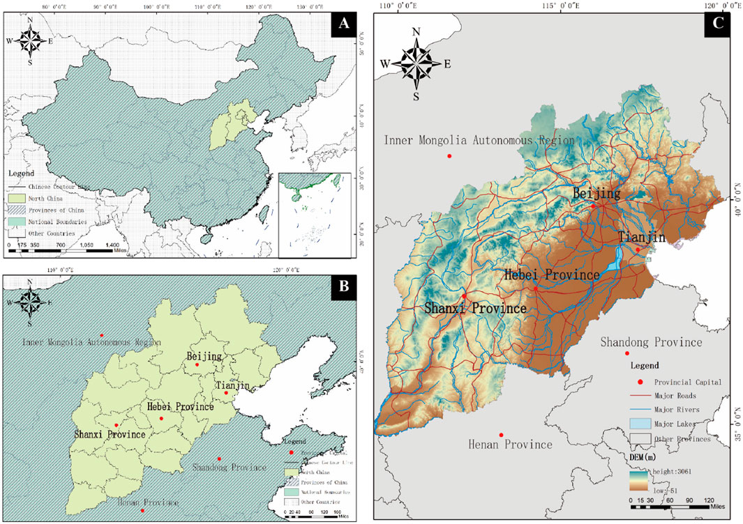
Figure 1. Land resource study area in North China (A) map of China; (B) map of the North China region; (C) geographic information map of North China (author’s own drawing) (bottom image source, https://www.gscloud.cn/#page1/1).
Most of the information used in this research comes from a number of statistical yearbooks, such as the China Environmental Statistical Yearbooks and the Beijing, Tianjin, Hebei, and Shanxi editions from 2012 to 2021. The official websites of the regional statistical bureaux and the annual statistical bulletins are additional sources of pertinent data. We maximize the volume of homogenous data by screening, classifying, combining, and eliminating the data. Finally, we acquired 21 indicators’ worth of data from four North Chinese provinces between 2012 and 2021. Land-use data (2015–2022) were obtained from the National Land Cover Database (NLCD) and cross-validated with Landsat-8 OLI/TIRS satellite imagery (30 m resolution). Socioeconomic data (e.g., population density and GDP) were sourced from the National Bureau of Statistics of China (annual reports) and the China City Statistical Yearbook. Environmental indicators (soil quality and water availability) were derived from the Chinese Academy of Sciences’ Resource and Environment Data Cloud Platform (1 km spatial resolution). Individual missing data for the indicators were supplemented by consulting the relevant literature.
2.2 Constructing an indicator system based on DPSIRM theory
1. According to the DPSIRM model: the exponent method used in this paper to evaluate the ESLR in North China is based on the DPSIRM model (Figure 2). The six components of the DPSIRM model are as follows: drivers: fundamental socioeconomic elements, such as population increase and patterns of economic development, which contribute to environmental issues; pressures: adverse effects brought on by drivers, such as resource use and pollution emissions; state: the current state of the environment, such as the quality of the soil or the water; impact: how a change in state affects ecosystems and human health; response: the reaction to an environmental issue, encompassing laws, policies, and other measures; and measures: practical actions and technical means to mitigate environmental problems and impacts (He et al., 2022; Liu et al., 2023).
2. Indicator system construction: integration of study area realities follows the scientific and rational principle of ESLR evaluation. Building upon the DPSIRM framework, in this study, we conducted a comprehensive assessment of land resource impacts through multidimensional evaluation across five critical societal dimensions: socioeconomic development, environmental quality, resource allocation, ecological integrity, and policy implementation. The analytical framework systematically integrates six core components—driving forces, environmental pressures, system states, ecological impacts, governance responses, and management strategies—which collectively guided the selection of 21 critical evaluation indicators (Du et al., 2023). This methodological approach enabled the construction of a three-tiered ecological security assessment system for land resources, organized hierarchically as shown in Table 1. The data in Table 1 were imported into SPSS software, and the weights were calculated.
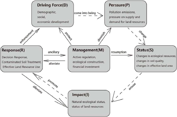
Figure 2. DPSIRM model of land ecological security (author’s own drawing).
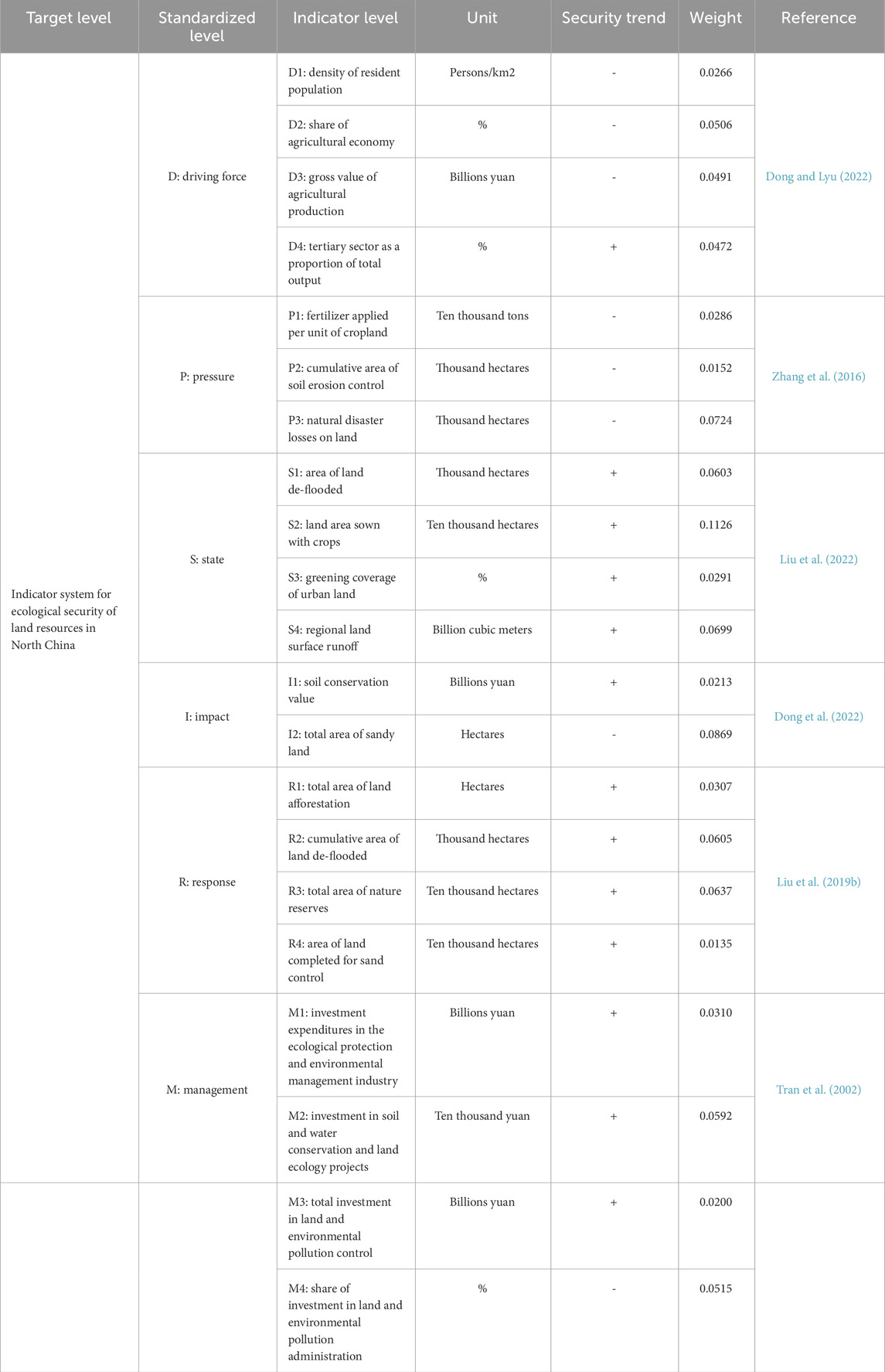
Table 1. Indicator system of ESLR in North China.
2.3 Weighted an entropy TOPSIS model
In terms of entropy magnitude, the TOPSIS model is a widely used integrated appraisal technique that smoothly minimizes the personal variables present with the traditional TOPSIS approach, makes the most of raw data samples, and accurately and realistically depicts how the influencing factors have changed over time (Jayasooriya et al., 2018). The entropy-weighted weight TOPSIS model is currently widely used in numerous fields, including to measure the degree of development of economic quality, assess the ecological and environmental carrying capacity of land assets, and evaluate land-use performance (Şengül et al., 2015).
Building a uniform assessment matrix for the sample data of North China’s land-use ecology is the first step. It is assumed that the
where (
Due to the original data sample, unit scale is not uniform; that is, polar deviation standardization is used to standardize the information at the formation of the indicator data matrix
For the inverse indicator,
where
Verifying each index’s dimension value is the second step. The weighting value of information entropy
where
In the third step, the normalized criteria former is constructed. The concrete formula is shown in Equation 6:
Finding the optimal solutions, both positive and negative, is the fourth step. The positive optimal answer
Performing the Euclidean distance calculation is the fifth step. The Euclidean distance and the comprehensive score of the appraisal of development of ESLR in North China to the positive and negative optimal solutions are determined. The concrete formulae are shown in Equations 9, 10:
Finding the ideal solution’s approximation value is the sixth step.
3 Analysis
3.1 Comprehensive evaluation of ESLR in North China
Between 2012 and 2021, the ESLR combined index [Land Resource Ecological Security (LRES)] in North China increased from 0.4968 to 0.5026. The values of LRES in North China from 2012 to 2021 were 0.4968, 0.4562, 0.4374, 0.4078, 0.4560, 0.4539, 0.5058, 0.5279, 0.4869, and 0.5026, respectively (Table 2), indicating a general upward trend with some fluctuations during the study period. This implies that China has implemented a variety of policies and methods to protect the natural ecology of its land resources, in addition to the concepts of “sustainable development” and “green development.” For instance, it has enhanced the standard of land farming and suggested certain particular methods for protecting the ecosystem and ecology of land. To increase the standard of the land, all segments of Chinese society must work together (Zhang et al., 2013). Simultaneously, the goals of ecological and environmental protection for land resources are achieved by merging North China’s real development (Table 3). In general, the ESLR in North China is gradually improving; despite occasional minor fluctuations in the process, the overall trend is upward (Figure 3), which can be divided into three phases:
1. First, there was a modest decrease between 2012 and 2015. The resident population density D1 increased from 768 persons/km2 to 790 persons/km2 based on the indicator data. There was an increase from 4,480.2 thousand hectares to 11,716 thousand hectares in the total area of soil erosion control P2. The amount of land damage caused by natural disasters increased from 2,464.8 thousand hectares to 2,957.9 thousand hectares. The ratio of investment in land and environmental pollution administration M4 decreased from 1.92% to 1.48%. The ESLR index was lowered by negative factors such as the density of the permanent population (D1), cumulative soil erosion control area (P2), land natural catastrophe loss (P3), and the ratio of land investment to environmental pollution administration (M4). The land de-flooding area (S1) decreased from 2,265.3 thousand hectares to 2,100.7 thousand hectares in the meantime. The soil conservation value (I1) decreased from 2.805 billion yuan to 2.472 billion yuan. Green covering S3 of urban land increased from 40.18% to 41.53%. The land resource ecological security index increased as a result of the benefits of urban land greening coverage (S3), soil conservation value (I1), and land de-flooding area (S1). The index somewhat decreased as a result of the overall negative consequences outweighing the good effects.
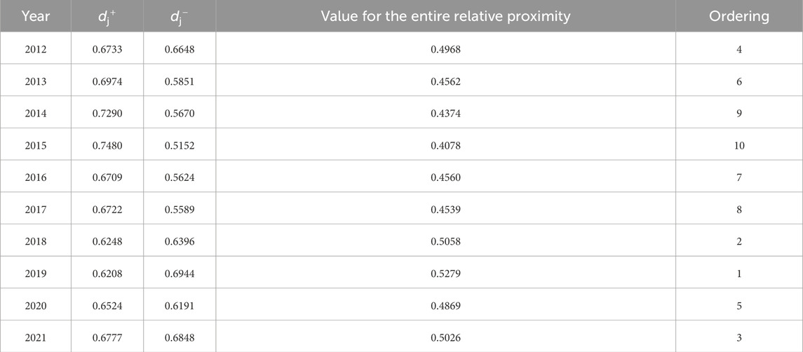
Table 2. North China’s relative proximity to ESLR, 2012–2021.

Table 3. Standards for evaluating the ecological safety carrying capacity of northern China’s land assets.
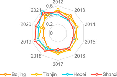
Figure 3. Radar map of changes in ESLR in four provinces (cities), 2012–2021 (author’s own drawing).
Since 2012, the state has performed a number of key engineering works in both the ecological and economic fields. The National Plan’s Overview for the Defense of Ecologically Vulnerable Areas, the Environmental and Economic Policies, the 12th Five-Year Plan for the Construction of National Environmental Protection Regulations, and the Ministry of Environment and Conservation’s Implementation Plan for Putting the Standing Committee of the National People’s Congress’s Resolution on Broadly Strengthening Ecological Conservation and Advancing the Fight to Prevent and Combat Pollution into Practice are only a few of the significant measures for ecological and economic construction that have been introduced. This has led to an annual decrease in the total amount spent on environmental pollution control and land. Regarding the overall trend of social advancement, it is gradually shifting toward the preservation of land resources and the prioritization of ecological safety such that the investment expenditure (M1) in the ecological protection and environmental governance industry has increased year by year.
2. A significant improvement phase was observed from 2016 to 2019. Indicatively, P3 on land natural disaster losses decreased from 2957.9 thousand hectares to 1406.9 thousand hectares. Investment expenditures in the ecological protection and environmental management industry (M1) increased significantly from 75.854 billion yuan to 127.975 billion yuan. Investment in soil and water conservation and land ecology projects M2 increased from 228,426.5 million yuan to 141,672.6 million yuan. The main reason for this is that the government has expanded its financial support for the construction of ESLR, driven by economic growth. At this point, North China started to completely execute initiatives for upgrading, protecting the quality of its land resources, and implementing institutional reforms. The preservation dynamics of ESLR and the ecologically responsible use of land resources are North China’s top priorities. In addition to a significant reduction in the degradation of land resources brought on by human activity, there has been a discernible improvement in the general state of land assets.
3. The stage of basic flatness was observed in 2019–2021. Regarding constructive contributing elements, fertilizer application per unit of cropland decreased from 4,281,200 metric tons to 4,044,700 metric tons in P2. The regional land surface runoff (S4) increased from 18.869 billion cubic meters to 60.383 billion cubic meters. Land natural catastrophe losses P3 increased from 21,406.9 thousand hectares to 1,523.7 thousand hectares due to unfavorable contributing variables. The total area of land sand prevention and control R4 was reduced from 264.1 thousand hectares to 187.6 thousand hectares. Passive impact aspects and active effective factors balance each other out. This is due to two factors: the improved capacity of land resources to self-regulate and the updated ecological safety index and better state of health. Second, the decrease in financial support under the economic slowdown has weakened investment in ecological safety management of land resources. Increased development of land resources in various regions has also increased the negative impacts of human behavioral activities on land resources.
3.1.1 Threshold division of the development level of land resource ecological carrying capacity in North China
3.1.2 Horizontal comparison of four provinces (municipalities) in northern China
According to the entropy-weight-TOPSIS method, relatively close values can be compared (Figure 3); from high to low, Tianjin (0.4470), Shanxi (0.4415), Hebei (0.4226), and Beijing (0.4176) ranked in North China’s ESLR (Figure 4).
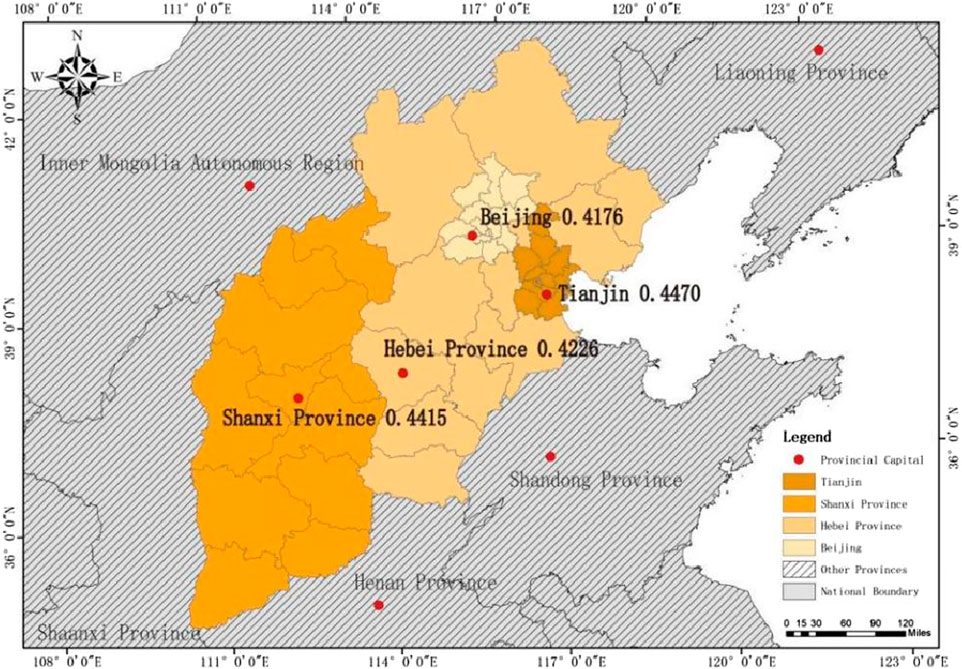
Figure 4. Relative proximity of ESLR in North China by region (author’s own drawing) (bottom image source, https://www.gscloud.cn/#page1/1).
The results showed that the land resource status of individual years in Hebei and Shanxi suddenly improved during the study period. The status of ESLR in Hebei 2021 and Shanxi 2019 was higher than that in other years. This is because Hebei completely banned businesses that disrupt the natural equilibrium of land resources and manufacturers that release excessive amounts of chemicals in 2021. According to the agreement, each region of the province is required to fulfill its important responsibility of conserving and using land resources while also responsibly enhancing ecological safety. There are two mountains, seven rivers, and one watershed in the Shanxi Province’s “14th Five-Year Plan” for ecological protection, along with plans for civilization construction, ecological and economic development, and ecological protection. These plans were released in 2019. Moreover, Beijing’s land resource status in 2020 increased rapidly and remained significantly higher than that in other years. The primary cause was the publication of the “2020 Ecological Environmental Protection Work Plan and Measures” by the Beijing Municipal Government in 2020. The Beijing municipal government firmly adheres to the long-term development plan for the ecological safety of Beijing’s natural resources and supports the building of infrastructure for the conservation of land resources. Notably, Beijing’s total land resource de-flooding area and the finished land sand-prevention and sand-control area have grown quickly, indicating the local government’s focus and commitment to land resource protection.
The development of Tianjin’s land resources is more erratic and generally in decline. Despite the ecological growth of its land resources, Tianjin has experienced fluctuations. Tianjin, however, deserves to be at the top because of its excellent efforts to maintain the ESLR in terms of natural disaster losses, fertilizer applied per unit of cropland, and funds for land resource protection. Additionally, Tianjin ranks first in the comprehensive index, which is higher than that of other provinces (municipalities). This is because, compared to other provinces (cities), Tianjin has the largest district total of nature reserves relative to the entire size of the territory. Moreover, Tianjin has a moderate continental environment, with a windy spring, drought and little rain, and concentrated rainfall in summer, which is beneficial to the conservation and advance of land resources.
3.1.3 Longitudinal comparison of four provinces (municipalities) in northern China
Together with the entropy-weighting results, the value for the total relative proximity of ESLR in each North Chinese area in 2012, 2014, 2016, 2018, 2020, and 2021 was calculated (Figure 5). The distribution map of evaluation grades in each region of the Yangtze River Basin during the research period was produced using ArcGIS10.8 software, which also divided the relative proximity index of land resource ecological security into five grades (Figure 6). In North China, the comprehensive index of ESLR grew by 12.94% from 2012 to 2021. ESLR indices in North China are gradually increasing. The Hebei region has the best ascending dimension of the ESLR index, whereas the great majority of provinces (cities) have elevated terrain. The forest conditions in the Shanxi region have gradually improved in recent years, showing an overall increasing trend. However, the Beijing area’s ESLR index has been in poor standing due to significant issues of poor land resource quality and mounting management pressure. Therefore, the four provinces (cities) in North China should strengthen land resource regulation, raise the standard of land assets, and effectively mitigate and protect land assets (Figure 7).
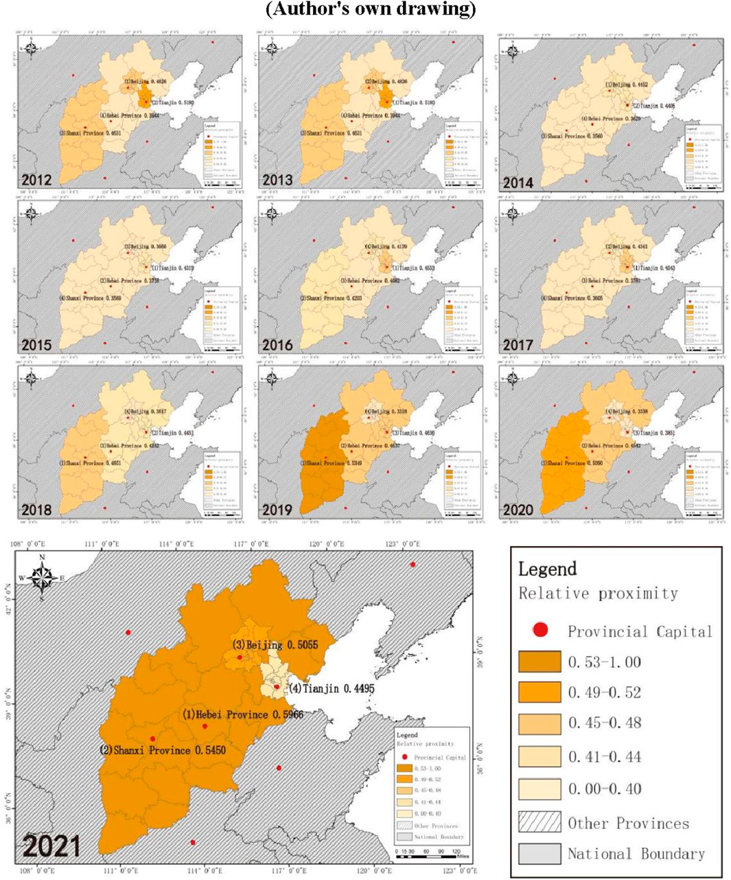
Figure 5. Distribution of North China’s land asset ecological safety assessment scores by regions, 2012–2021 (author’s own drawing) (bottom image source, https://www.gscloud.cn/#page1/1).
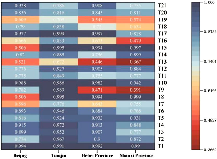
Figure 6. Heat correlation of gray correlation between North China and objective status indicators (indicator layer) (author’s own drawing).
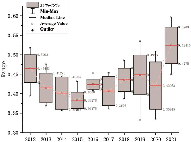
Figure 7. Trends in land resource box plots by area in North China, 2012–2021 (author’s own drawing).
The size of the land region and the ecological condition of the land assets affect the state of the land assets in the majority of North China’s districts. In 2021, Beijing’s area was 16,800 square kilometers, Tianjin’s area was 11,300 square kilometers, Hebei’s area was 187,700 square kilometers, and Shanxi’s area was 156,300 square kilometers. The Hebei and Shanxi regions can use biological improvements such as afforestation to organically repair the ecology of land resources, based on the advantage of the land area size. As a result, it is noted that the ESLR indices in the Hebei and Shanxi regions have been steadily increasing since 2016, whereas the indices in Beijing and Tianjin have been decreasing since 2012 due to land area size restrictions and did not begin to increase again until 2021. Furthermore, the issue of soil corrosion is more severe in Beijing and Tianjin than in Hebei and Shanxi as they are situated at the mouth of the sea and downstream of the Yellow River, respectively. Therefore, land resource ministries, relevant parties, and authorities at all levels should conduct a detailed analysis of the fundamental causes of land resource problems. Targeted methods should then be adopted, improved, and refined in accordance with local conditions. In conclusion, during the period of 2012–2021, the level of ESLR in North China has increased significantly, but there remain differentiations among provinces (cities) (Table 4).
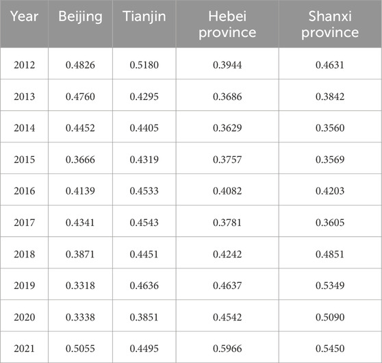
Table 4. Values of evaluation of ESLR by province (city) in North China from 2012 to 2021.
3.2 Indicator correlation analysis
3.2.1 Gray scale correlation analysis method of data calculation
Finding the sequence array based on the evaluation objective is the first step. The characteristic sequence is the data sequence composed of elements influencing the land environment factor in the quality evaluation score method of ESLR in North China. Let Rij be the information from the ith evaluated object’s jth indicator, Rij be its characteristic sequence, and m be the number of indicators; moreover, there exists n characteristic in order Ri, composed of the following model (Equation 12):
Determining the reference sequence in the sequence matrix, the reference sequence is the data sequence composed of the index of ESLR in North China. By comparing the characteristic sequence with the mention sequence, the proximity of each evaluation object to the influencing factors can be calculated. Let its reference sequence be S0; if n is the number of appraisal objects, then the reference sequence is composed of n data (Equation 13):
The index data are dimensionless in the second stage. Given that each factor that influences determines the ecological environment index of land assets in North China, according to the distribution law of each index data, the characteristic series information are dimensionless by using homogenization, as shown in Equation 14.
During the third stage, each feature sequence’s absolute difference from the reference consecutiveness’s comparative element is calculated. Let the categorical difference between the feature sequence of the ith assessed target and the comparative element of the reference sequence be Δij; when n is the number of targets that have been evaluated, the specific computation is displayed in Equation 15.
Two-stage minimum difference Δimin and two-stage maximum difference Δimax were finalized based on each absolute difference as Δi, which were calculated as in Equations 16, 17.
In the fourth step, the association coefficient (∂i) of each feature sequence with the pertinent reference sequence element is tallied appropriately. Eventually, each indicator’s average weighting of the relevance values among it and the pertinent reference sequence element is tallied accordingly (Gi). (Gi) is the final calculated degree of gray correlation, which can demonstrate the extent of relevance between the objective condition of land resource ecology and the driving elements in North China. The concrete computation is shown in Equations 18, 19,
In Equation 18, ρ is the discrimination coefficient, taking values in (0,1); the smaller the value of x, the greater the difference among the relevance values and the stronger the distinction ability. ωj in Equation 19 is the weight of each indicator.
3.2.2 Ranking of influencing factors
The gray correlation between the 21 indicators in the indicator layer has a maximum amplitude of 0.448 and a range of 0.549–0.997. The overall area of sandy land in E13, which has the highest gray correlation, is only 1.29 times larger than the investment made in soil and water preservation and land ecological items in E19, which has the lowest gray correlation. This indicates that the correlation difference between the indicators is not very large. It demonstrates that the geometric distribution pattern of the indicators influencing the ESLR in North China exhibits a certain association. The minimal polarity difference between particular extremes further suggests that the indicators chosen for this investigation were somewhat logical (Table 5).
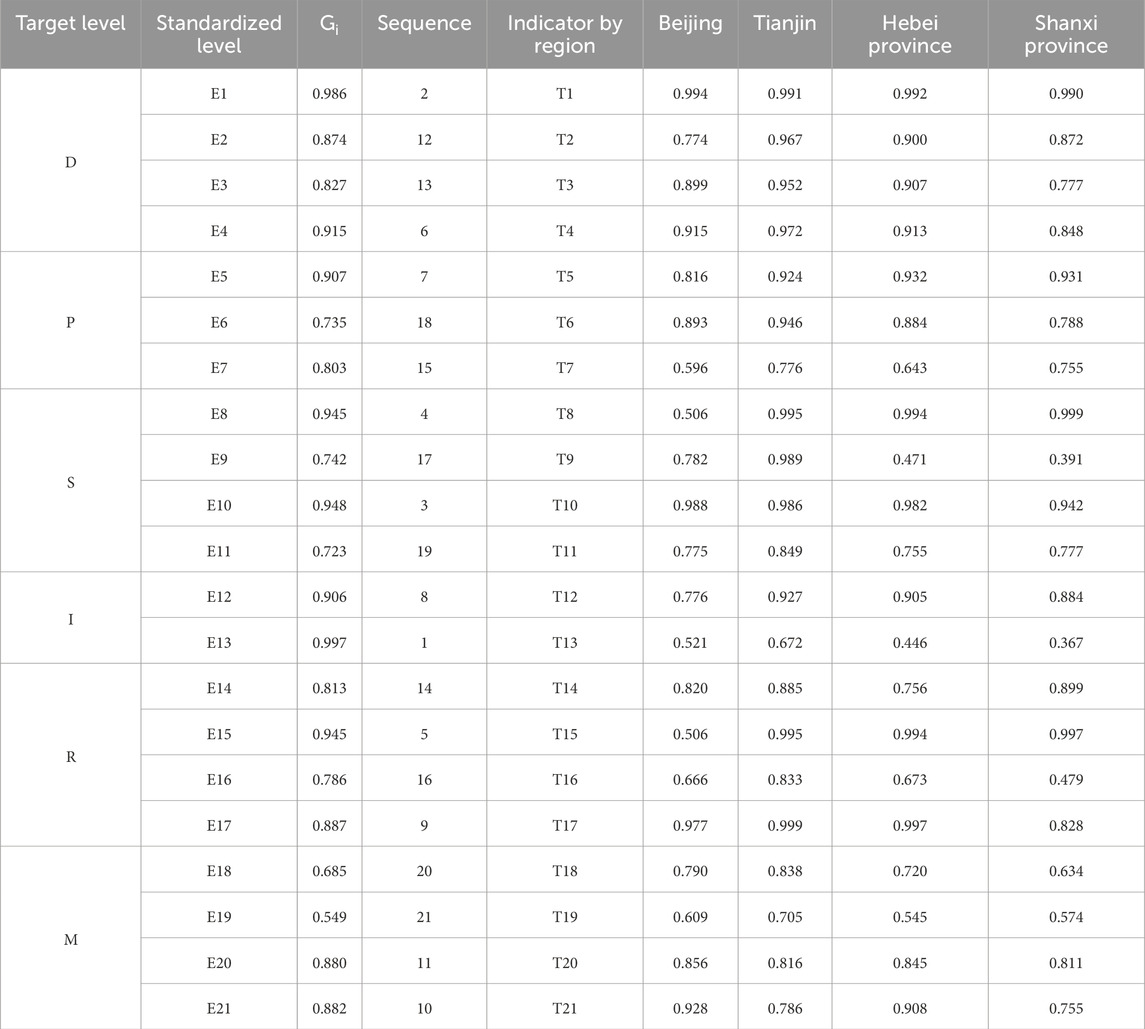
Table 5. Gray correlation between the corresponding indicators in each region and the environmentally friendly quality indicators of North China’s land assets.
In the descending order, for every indicator, the following are the top five entirety gray correlations: E13 (0.997) > E1 (0.986) > E10 (0.948) > E8 (0.945) > E15 (0.945). In decreasing order, the following are the bottom five entirety gray associations for each indicator: E19 (0.549) < E18 (0.685) < E11 (0.723) < E6 (0.735) < E9 (0.742). It shows that the entire district of E13 sandy land has the greatest influence on the environmental state of land assets in North China. In E13, the ecology of land resources is significantly impacted by the entire sandy land region, and sanding the land somewhat exacerbates the issues of soil erosion and desertification. Because of this, there is less water available annually, which makes windstorms and droughts in the area more severe. High-quality soil can improve a region’s environmental quality by creating an environment that is conducive to overall ecological security. Increased levels of land resources can lead to more efficient internal ecological cycles in a region, thus providing better ecosystems and conditions to improve environmental quality. For example, healthy soils can cultivate and produce healthy food, vegetation, feed, fiber, fuel, and medicine.
The significance of land is reflected in the fact that it can increase our resilience to droughts and floods and that an essential component of the carbon cycle is soil. Therefore, it is evident that the entire E13 sandy land district serves as an indirect indicator of the amount of ESLR in a given area. Consequently, it makes sense that the largest gray correlation is found in the total amount of sandy terrain in E13. In North China, E19 investment in land ecology and soil and water preservation initiatives had the least impact on the ESLR. Perhaps, this is because investments in soil and water preservation and land ecology items in a region primarily reflect the income and expenditures of the economy. On the other hand, from a functional perspective, these investments include a number of aspects, such as the marking of land boundaries, the acquisition of township industrial and rural residential land, the development of comprehensive roads, forest networks, ditches, and other infrastructure, and the provision of public services. This could result in a lack of funding from the public sector to address every facet of enhancing the ecological quality of land resources.
It shows that, in North China, the E8 land drainage area and the E15 land cumulative drainage area have a greater influence on the quality of land resources than the E1 resident population density and E10 urban land greening coverage. Improving the quality of North China’s land resources will be facilitated by concentrating on these areas.
4 Conclusion and discussion
4.1 Conclusion
The North China Plain occupies approximately 300,000 square kilometers or 3.2% of China’s total land area. With a GDP of 25.16 trillion yuan in 2019, the North China Plain accounted for 25.4% of China’s GDP and is home to 339 million people or 24.3% of the country’s total population. Furthermore, the GDP per person in the area was 74,218 yuan. North China may better leverage the fundamental support of land resources for economic development by protecting them. It is crucial for both accelerating regional growth and accomplishing the strategic goal of “erecting a modern, socialist, prosperous, powerful, democratic, peaceful, and environmentally friendly nation” by 2050. In light of the problems with North China’s land resources and the results of information analysis, in this study, we summarize the current status of land assets and offer the following practical suggestions to further improve their condition.
1. The ESLR index is generally trending upward in North China during the 2012–2021 period, with a slight decrease in the middle. The performance level first decreases slightly, remaining at the low end of the intermediate level, and then decreases to the low stage in the middle of 2015, before rapidly increasing to the good stage and fluctuating in the later period, but overall, the situation is good. The land-use policies at every stage have been successfully implemented, especially after the development and accumulation of the 13th and 12th Five-Year Plans. This is demonstrated by changes in the ecological safety index and land resources that match the evolving land-use requirements in the two Five-Year Plans. In light of regional planning at the beginning of the “14th Five-Year Plan,” regional peculiarities, and ecological issues, province (municipal) authorities at all levels should continue to advance and protect the ESLR in the area. They can support the district’s cultural, social, and economic development in this way. During the land resource development process, to guarantee long-term growth of the local land resources, we could also adhere to the principle of moderation.
2. From the point of view of the indicators of each province (city), there are also obvious characteristics of stage changes. The ESLR index continued to strengthen throughout the study period: the Beijing indicator experienced a sharp decrease in the first and middle stages, followed by a sharp increase in the later stages; the Tianjin indicator experienced a gradual decrease in the first phase, stabilization in the middle, and a subsequent ascent; the Hebei indicator displayed a significant increase and an overall upward trend; and the Shanxi indicator experienced a decrease in the first stage, followed by a uniform increase in the middle and later stages. In the Shanxi region, the indicator changes increased uniformly in the middle and late phases after decreasing in the early phases. The index of ESLR reflects the quality and per capita enjoyment of land resources, which is extremely influenced by the population size, and the index of ESLR is lower in the more densely populated areas. This is relative rather than absolute, although, for instance, the land resource ecological security index for the Beijing area increased quickly in 2020–2021, catching up to other provinces (cities). Despite fluctuations brought on by changes in land policy, the index change remained steady between 2014 and 2018; however, toward the end of the study period, there were signs of an upward trend. The government should always be in charge, and each province (city) should take action for its own area to guarantee that the ecological preservation of land resources is strengthened. First, the government should formulate actual ecological safety conservation policies. Second, localities could strengthen the supervision of pollution sources of land resources, promote ecological infrastructure projects, and rationally utilize land ecological resources.
3. The caliber and professionalism of agricultural practitioners and those in environmental protection disciplines should be improved, considering the current state of land assets in most districts. Regular training and professionalism evaluations all contribute to their overall quality improvement. This is accomplished in two primary ways: on the one hand, North Chinese higher education institutions offer a variety of agronomy and land resource majors. To increase the scientific and technological proficiency of agronomy majors, the findings of the schools’ scientific investigations are converted into technical achievements. On the other hand, the importance of introducing scientific and technological talents specialized in agronomy is increased. The professional ability of practitioners in environmental protection-related departments is cultivated, given the present-day condition of land assets in the majority of districts, and the caliber and professionalism of agricultural practitioners and those in fields related to environmental protection are enhanced. The promotion of the ESLR is not only supported by the skills and work of professionals but also depends on the participation of the general citizen. The government uses various channels, such as the Internet, television, and various media, to publicize to the masses the damage done to land resources and the impacts brought to human beings. It mobilizes the general citizen to enter into the building and conservancy of the ecological environment.
4.2 Discussion
Built on the above data analysis, in this study, we propose the following points of view for provinces (cities) with diverse resource states and economic development levels. First, there is a general increasing tendency and a comparatively steady land resource condition in the Hebei (0.5966) and Shanxi (0.5450) regions. The management of land assets, particularly the protection of agricultural land and ecological wetlands, must be insisted upon by the aforementioned districts. These two provinces (municipalities) should honestly implement authoritative land resource conservation and utilization projects and initiatives to promote integrated management of degraded land resource ecosystem.
The need for region-specific land-use planning is highlighted in this study to address the uneven distribution of urbanization and agricultural intensification. For instance, the plain region requires stricter controls on farmland conversion to urban areas, whereas mountainous areas need policies to promote ecological restoration. Integrated water–soil management strategies are recommended, particularly in water-scarce regions, to balance agricultural productivity and environmental sustainability. The findings support the adoption of spatially explicit zoning policies to mitigate conflicts between urban expansion and ecological conservation.
Second, some areas have higher levels of economic development, better local financial revenues, and more abundant resources. For example, Beijing (0.5055) and Tianjin (0.4495) have large space and sufficient margin for land resource ecosystem improvement. To develop soil hydraulics, soil engineering, soil biology, soil chemistry, and soil tillage, the aforementioned regions must guarantee adequate funding. Meanwhile, the management of land resource pollution sources in developed areas has increased, and the emission of polluted soil chemicals has decreased against the backdrop of the shift in the country’s economic development. Urban expansion is identified as a primary driver of land-use change, particularly in the plains and coastal regions. In the study, we show that urban sprawl leads to the loss of high-quality farmland and fragmentation of natural habitats. Regions with higher GDP per capita show not only more rapid urban expansion but also greater investment in environmental protection, highlighting the dual role of economic development.
Third, the provinces and municipalities in the North China region should increase their efforts to safeguard the region’s land resources and soil quality, ensuring that the ecological red line oversight system is strictly adhered to. They should also lessen the burden that humans place on the earth’s resources, develop more sustainable land resource governance, and successfully increase the carrying capacity of the ecosystem. They should also encourage structural transformation and the coordinated evolution of resources and the economy, while focusing on improving population quality and enhancing job security to mitigate conflicts between land and people.
This experiment still has shortcomings that need to be further optimized. Only a few evaluation indices with high accessibility are chosen to build the index system, with reference to the existing research results. The selection of indicators for ESLR evaluation in this research is subjective, with many influencing factors, and it was challenging to select the evaluation indices in this paper due to the difficulty in obtaining some key data. Aiming at the subjective defects of traditional indicator weight assignment, in this study, we propose a new composite assignment model-integrating entropy-weight method, spatial autocorrelation analysis, and geodetector, whose innovativeness is reflected in the coupled iterative calculation of statistical weight and spatial heterogeneity characteristics. The policy insights found in the study (e.g., land intensive utilization thresholds in coastal industrial zones and security early warning mechanism for inland ecologically fragile zones) have been incorporated into local pilot territorial spatial planning, which verifies the innovative closure of this study from theoretical modeling to management practice. This study lacks the prediction of the future ecological safety carrying capacity of land resources, so further research is needed on how to make the build of the factor appraisal system more scientific and logical, and which appraisal method to select.
Data availability statement
The datasets presented in this study can be found in online repositories. The names of the repository/repositories and accession number(s) can be found in the article/supplementary material.
Author contributions
HL: Conceptualization, Methodology, Project administration, Writing – original draft, Writing – review and editing. KG: Investigation, Methodology, Project administration, Software, Validation, Writing – original draft, Writing – review and editing.
Funding
The author(s) declare that financial support was received for the research and/or publication of this article. This work was supported by the Anhui Provincial Philosophy and Social Sciences Project: Project Number: (AHSKYQ2024D062).
Conflict of interest
The authors declare that the research was conducted in the absence of any commercial or financial relationships that could be construed as a potential conflict of interest.
Generative AI statement
The author(s) declare that no Generative AI was used in the creation of this manuscript.
Any alternative text (alt text) provided alongside figures in this article has been generated by Frontiers with the support of artificial intelligence and reasonable efforts have been made to ensure accuracy, including review by the authors wherever possible. If you identify any issues, please contact us.
Publisher’s note
All claims expressed in this article are solely those of the authors and do not necessarily represent those of their affiliated organizations, or those of the publisher, the editors and the reviewers. Any product that may be evaluated in this article, or claim that may be made by its manufacturer, is not guaranteed or endorsed by the publisher.
References
Ahmed, Z., Asghar, M. M., Malik, M. N., and Nawaz, K. (2020). Moving towards a sustainable environment: the dynamic linkage between natural resources, human capital, urbanization, economic growth, and ecological footprint in China. Resour. Policy 67 (101677), 101677. doi:10.1016/j.resourpol.2020.101677
Cao, Y., Kong, L., Zhang, L., and Ouyang, Z. (2020). Spatial characteristics of ecological degradation and restoration in China from 2000 to 2015 using remote sensing. Restor. Ecol. 28 (6), 1419–1430. doi:10.1111/rec.13226
Chen, F., Wu, S., Peng, C. U. I., Cai, Y., Zhang, Y., Yin, Y., et al. (2020). 1949—2019 acta. Geogr. Sin. 75 (9), 1799–1830. doi:10.11821/dlxb202009001
Dong, J., and Lyu, Y. (2022). Appraisal of urban land ecological security and analysis of influencing factors: a case Study of Hefei City, China. Environ. Sci. Pollut. Res. Int. 29 (60), 90803–90819. doi:10.1007/s11356-022-22029-5
Dong, Z., Zhang, J., Tong, Z., Han, A., and Zhi, F. (2022). Ecological security assessment of xilingol grassland in China using DPSIRM model. Ecol. Indic. 143 (109336), 109336. doi:10.1016/j.ecolind.2022.109336
Du, W., Liao, X., Tong, Z., Rina, S., Rong, G., Zhang, J., et al. (2023). Early warning and scenario simulation of ecological security based on DPSIRM model and bayesian network: a case Study of East Liaohe River in Jilin Province, China. J. Clean. Prod. 398 (136649), 136649. doi:10.1016/j.jclepro.2023.136649
Fan, Y., and Fang, C. (2020). Evolution process and obstacle factors of ecological security in Western China, a case Study of Qinghai Province. Ecol. Indic. 117 (106659), 106659. doi:10.1016/j.ecolind.2020.106659
Flint, N., Rolfe, J., Jones, C. E., Sellens, C., Johnston, N. D., and Ukkola, L. (2017). An ecosystem health index for a large and variable River Basin: methodology, challenges and continuous improvement in Queensland’s Fitzroy Basin. Ecol. Indic. 73, 626–636. doi:10.1016/j.ecolind.2016.10.007
He, N., Zhou, Y., Wang, L., Li, Q., Zuo, Q., Liu, J., et al. (2022). Spatiotemporal evaluation and analysis of cultivated land ecological security based on the DPSIR model in Enshi autonomous prefecture, China. Ecol. Indic. 145 (109619), 109619. doi:10.1016/j.ecolind.2022.109619
Jayasooriya, V. M., Muthukumaran, S., Ng, A. W. M., and Perera, B. J. C. (2018). Multi criteria decision making in selecting stormwater management green infrastructure for industrial areas part 2: a case Study with TOPSIS. Water Resour. manage. 32 (13), 4297–4312. doi:10.1007/s11269-018-2052-z
Juanita, A.-D., Ignacio, P., Jorgelina, G.-A., Cecilia, A.-S., Carlos, M., and Francisco, N. (2019). Assessing the effects of past and future land cover changes in ecosystem services, disservices and biodiversity: a case Study in Barranquilla Metropolitan Area (BMA), Colombia. Ecosyst. Serv. 37 (100915), 100915. doi:10.1016/j.ecoser.2019.100915
Kesgin Atak, B., and Ersoy Tonyaloğlu, E. (2020). Monitoring the spatiotemporal changes in regional ecosystem health: a case Study in Izmir, Turkey. Environ. Monit. Assess. 192 (6), 385. doi:10.1007/s10661-020-08357-4
Li, V., and Lang, G. (2010). China’s “Green GDP” experiment and the struggle for ecological modernisation. J. Contemp. Asia 40 (1), 44–62. doi:10.1080/00472330903270346
Liu, W., Zhan, J., Zhao, F., Yan, H., Zhang, F., and Wei, X. (2019a). Impacts of urbanization-induced land-use changes on ecosystem services: a case Study of the Pearl river Delta metropolitan region, China. Ecol. Indic. 98, 228–238. doi:10.1016/j.ecolind.2018.10.054
Liu, Y., Song, W., and Deng, X. (2019b). Understanding the spatiotemporal variation of urban land expansion in oasis cities by integrating remote sensing and multi-dimensional DPSIR-based indicators. Ecol. Indic. 96, 23–37. doi:10.1016/j.ecolind.2018.01.029
Liu, X., Huang, Y., Xu, X., Li, X., Li, X., Ciais, P., et al. (2020). High-spatiotemporal-Resolution mapping of global urban change from 1985 to 2015. Nat. Sustain. 3 (7), 564–570. doi:10.1038/s41893-020-0521-x
Liu, C., Li, W., Xu, J., Zhou, H., Li, C., and Wang, W. (2022). Global trends and characteristics of ecological security research in the early 21st century: a literature review and bibliometric analysis. Ecol. Indic. 137 (108734), 108734. doi:10.1016/j.ecolind.2022.108734
Liu, J., Cao, X., Zhao, L., Dong, G., and Jia, K. (2022). Spatiotemporal differentiation of land ecological security and its influencing factors: a case Study in Jinan, Shandong Province, China. Front. Environ. Sci. 10, 824254. doi:10.3389/fenvs.2022.824254
Liu, Y., Wang, C., Wang, H., Chang, Y., Yang, X., Zang, F., et al. (2023). An integrated ecological security early-warning framework in the national Nature reserve based on the gray model. J. Nat. Conserv. 73 (126394), 126394. doi:10.1016/j.jnc.2023.126394
Logan, M., Hu, Z., Brinkman, R., Sun, S., Sun, X., and Schaffelke, B. (2020). Ecosystem health report cards: an overview of frameworks and analytical methodologies. Ecol. Indic. 113 (105834), 105834. doi:10.1016/j.ecolind.2019.105834
Şengül, Ü., Eren, M., Eslamian Shiraz, S., Gezder, V., and Şengül, A. B. (2015). Fuzzy TOPSIS method for ranking renewable energy supply systems in Turkey. Renew. Energy 75, 617–625. doi:10.1016/j.renene.2014.10.045
Shan, Y., Wei, S., Yuan, W., and Miao, Y. (2022). Evaluation and prediction of land ecological security in Shenzhen based on DPSIR-TOPSIS-GM(1,1) model. PLoS One 17 (11), e0265810. doi:10.1371/journal.pone.0265810
Steffen, W., Richardson, K., Rockström, J., Cornell, S. E., Fetzer, I., Bennett, E. M., et al. (2015). Planetary boundaries: guiding human development on a changing planet. Science 347 (6223), 1259855. doi:10.1126/science.1259855
Tran, L. T., Knight, C. G., O’Neill, R. V., Smith, E. R., Riitters, K. H., and Wickham, J. (2002). Fuzzy decision analysis for integrated environmental vulnerability assessment of the mid-atlantic region 1. Environ. Manage. 29 (6), 845–859. doi:10.1007/s00267-001-2587-1
Westing, A. H. (1989). The environmental component of comprehensive security. Bull. Peace Propos. 20 (2), 129–134. doi:10.1177/096701068902000203
Wu, K.-Y., and Zhang, H. (2012). Land use dynamics, Built-up land expansion patterns, and driving forces analysis of the fast-growing hangzhou metropolitan area, eastern China (1978–2008). Appl. Geogr. 34, 137–145. doi:10.1016/j.apgeog.2011.11.006
Wu, Y., Tao, Y., Yang, G., Ou, W., Pueppke, S., Sun, X., et al. (2019). Impact of land use change on multiple ecosystem services in the rapidly urbanizing kunshan city of China: past trajectories and future projections. Land Use Policy 85, 419–427. doi:10.1016/j.landusepol.2019.04.022
Xie, H., He, Y., Choi, Y., Chen, Q., and Cheng, H. (2020). Warning of negative effects of land-use changes on ecological security based on GIS. Sci. Total Environ. 704 (135427), 135427. doi:10.1016/j.scitotenv.2019.135427
Yang, R., Du, W., and Yang, Z. (2021). Spatiotemporal evolution and influencing factors of urban land ecological security in Yunnan province. Sustainability 13 (5), 2936. doi:10.3390/su13052936
Ye, X., Zou, C., Liu, G., Lin, N., and Xu, M.(2018). Main research contents and advances in the ecological security pattern. Sheng Tai Xue Bao 38 (10).
Zhang, R., Zheng, H. ,, and Liu, Y. (2013). Evaluation on cultivated land ecological security based on the PSR model and matter element analysis. Sheng Tai Xue Bao 33 (16), 5090–5100. doi:10.5846/stxb201209191319
Zhang, F., Zhang, J., Wu, R., Ma, Q., and Yang, J. (2016). Ecosystem health assessment based on DPSIRM framework and health distance model in nansi Lake, China. Stoch. Environ. Res. Risk Assess. 30 (4), 1235–1247. doi:10.1007/s00477-015-1109-2
Zhang, X., Wang, Y., Yuan, X., and Yang, Y. (2022). Regional land ecological security evaluation and ecological poverty alleviation practice: a case study of yangxian county in Shaanxi Province, China. J. Geogr. Sci. 32 (4), 682–700. doi:10.1007/s11442-022-1967-8
Zhang, F., Jiang, C., Ma, D., Yang, X., Xiao, Y., and Tan, H. (2023). Evaluation of tourism ecological security based on DPSIRM-SBM model and its temporal–spatial evolution characteristics. Environ. Dev. Sustain. 26 (7), 18111–18137. doi:10.1007/s10668-023-03381-z
Zhou, J., Wang, X., Lu, D., Dan, S. F., Kang, Z., Xu, Y., et al. (2022). Ecological security assessment of qinzhou coastal zone based on driving forces-pressure-state-impact-response (DPSIR) model. Front. Mar. Sci. 9, 1009897. doi:10.3389/fmars.2022.1009897
Keywords: land resource security, fuzzy evaluation, North China, DPSIRM, TOPSIS model
Citation: Lu H and Ge K (2025) Research on the differences in the spatial distribution of land resource security in North China based on the DPSIRM model. Front. Earth Sci. 13:1534577. doi: 10.3389/feart.2025.1534577
Received: 26 November 2024; Accepted: 14 August 2025;
Published: 25 September 2025.
Edited by:
Manuel Miguel Jordán, Miguel Hernández University of Elche, SpainReviewed by:
Medani Bhandari, Akamai University, United StatesMohamed A.E. AbdelRahman, National Authority for Remote Sensing and Space Sciences, Egypt
Copyright © 2025 Lu and Ge. This is an open-access article distributed under the terms of the Creative Commons Attribution License (CC BY). The use, distribution or reproduction in other forums is permitted, provided the original author(s) and the copyright owner(s) are credited and that the original publication in this journal is cited, in accordance with accepted academic practice. No use, distribution or reproduction is permitted which does not comply with these terms.
*Correspondence: Kunyin Ge, bjIzMzAxMDU2QHN0dS5haHUuZWR1LmNu