 ShengQiang Yuan1Chengqian Yu2Xingyang Zhang1Guanghua Zhai3*
 Ronald J. Steel4
 Si Chen5*Hairong Wang2Hong Jiang1Yifan Song1
 Jinyan Song5
- 1Research Institute of Petroleum Exploration & Development, PetroChina, Beijing, China
- 2School of Energy Resource, China University of Geosciences, Beijing, China
- 3China National Oil and Gas Exploration and Development Corporation, Beijing, China
- 4Jackson School of Geosciences, The University of Texas at Austin, Austin, TX, United States
- 5Faculty of Earth Resources, China University of Geosciences, Wuhan, China
Tidal characteristics observed in sediment cores serve as significant indicators of marine paleo-environments. In order to comprehend the sedimentary processes taking place in the Termit Basin and its connections with the New Tethys and the southern Atlantic Ocean during the Late Cretaceous, a comprehensive array of sedimentological and petrographic analyses have been performed on the core data, thin sections, seismic data, paleontological fossils, and drilling samples from the Termit Basin. New insights into tidal sedimentary processes were obtained through this research, and sedimentological evidence for the development of transgressive sequences in the study area was established. Analysis of lithofacies, paleontological fossils, and fossil contents shows that the Termit, Iullemeden, Tefidet, and Tenere basins together formed a unified sedimentary basin in the Late Cretaceous. Well correlation and seismic profiling analysis also confirm this view. The unified sedimentary basin was connected to the northern New Tethys and the southern Atlantic Ocean. Stratigraphic analyses revealed that the Late Cretaceous of the Termit Basin underwent a complete episode of marine transgression. The discovery of Tidal features such as bidirectional cross-bedding and double mud drapes in Late Cretaceous Yogou Formation cores in the Termit Basin provide compelling evidence of their connection to the central Saharan Seaway, suggesting that the sedimentary basin was connected to the northern New Tethys and the South Atlantic Ocean. This study also explores the source supply system, development features of carbonate rock, the prototype basin, and the hydrocarbon exploration potential of the Late Cretaceous Termit Basin. The results of this study reveal the following: (i) the Late Cretaceous Yogou Formation in the Termit Basin exhibits well-developed tidal processes; (ii) an extensive transgression occurred, encompassing a series of basins in eastern Niger, which led to the inclusion of these areas within the Saharan Seaway during the Late Cretaceous; (iii) the deposition of mudstone over a wider area of the Late Cretaceous Termit Basin, indicating the existence of more source rocks and resources to be developed.
1 Introduction
Termit Basin, a Cretaceous–Tertiary superimposed basin, is located in the larger Eastern Niger Basin (Figure 1). A large scale transgression occurred in the Late Cretaceous and a large area of Marine strata was deposited in the study area, forming a unique Marine and terrestrial rift superimposed basin in the Central and Western African rift system, which provided a perfect environmental basis for oil and gas accumulation. In addition, The presence of good to excellent source rocks (Harouna and Philp, 2012; Liu et al., 2012; Wan et al., 2014; Harouna et al., 2017; Liu et al., 2015; 2019; Xiao et al., 2019) alongside high-quality reservoirs and seals (Genik, 1992; Liu et al., 2017; Mao et al., 2020; Liu et al., 2022; Yuan et al., 2023) indicates favorable potential for hydrocarbon exploration in the Termit Basin.
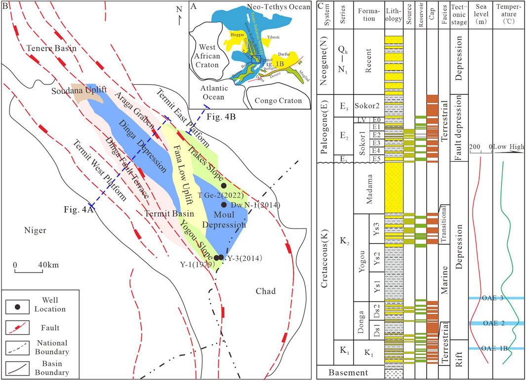
Figure 1. (A) Location of the Termit Basin and the Trans-Saharan Seaway; (B) Comprehensive map of tectonic framework of the Termit Basin (Modified from Yuan et al., 2018); (C) sedimentary filling and evolution of the Termit Basin (Modified from Genik, 1992; Guiraud et al., 2005; Yuan et al., 2018; Edegbai et al., 2019).
In West Africa, the seaways formed by transgression in the Late Cretaceous connected multiple basins, forming a temporary unified lithofacies paleogeographic feature during the transgression (Figure 1A). The basins surrounding the Termit basin exhibited diverse transgressive indicators during the Late Cretaceous period. Numerous marine outcrops have been discovered in various locations, including the Iullemeden Basin to the west of the Termit Basin, the Benue Trough and Bida Basin in the southwest, the Bilma Basin and Tefidt Basin in the north, and Algeria in the northwest. These areas exhibit typical marine indicators affected by marine ingression events, such as glauconite, marine limestone, sandstone and mudstone with Marine characteristics (Figure 2)(Moody and Sutcliffe, 1991; Zaborski and Morris, 1999). Furthermore, drilling activities in these basins have yielded fossil contents and biomarkers that further support the presence of marine facies, including dinoflagellates, marine ostracoids, calcareous microfossils, and foraminifera (Reyment, 1980; Kogbe, 1981; Ojo and Akande, 2009; Edegbai et al., 2019; Konate et al., 2019). Thick deposits of limestone, marl, shale, siltstone, and sandstone have accumulated in these basins, with nearly 30% of the upper Cretaceous strata in the Iullemeden basin consisting of grain limestones (Pascal et al., 1993), including a distinctive layer known as the “white limestone” formation (Moody and Sutcliffe, 1991). In the Iullemeden Basin, four sets of Late Cretaceous strata are identified as marine deposits, frequently exhibiting the presence of marine limestone in numerous outcrops. These limestone formations contain identifiable fossils such as ammonites, marine bivalves, fish, and amphibious reptiles. Notably, several ammonite-bearing Libycoceras beds provide clear evidence of marine stratum development and migration. The Late Cretaceous period in the Iullemeden Basin was predominantly characterized by a shelf and coastal environment (Moody and Sutcliffe, 1991; Zaborski and Morris, 1999). Similarly, the Sokoto Basin exhibits distinct marine characteristics, including tidal influence, gypsum deposits, limestone formations (containing fossils like corals and gastropods), shale layers, as well as trace fossils such as Ophiomorpha, Skolithos, Thalassinoides (Kogbe, 1981; Edegbai et al., 2019).

Figure 2. The regional distribution and location map of marine facies marks, Eastern Niger and nearby area (Reyment, 1980; Kogbe, 1981; Gebhardt, 1998; Ojo and Akande, 2009; Edegbai et al., 2019; Konate et al., 2019).
Ojo and Akande (2009) conducted a study on the Upper Cretaceous Patti Formation in the Bida Basin, where they identified various sedimentary indicators. These indicators included burrows, hummocky and herringbone cross-beddings, as well as marine bivalves. Additionally, they observed a dinoflagellate assemblage consisting of Dinogymnium, Deflandrea, and Spiniferites. Based on these findings, they interpreted the strata as coastal facies encompassing shoreline environments, tidal channels, and tidal and coastal marshes. It is noteworthy that throughout the Bida Basin, from the late Cenomanian to Maastrichtian periods, the strata contain varying quantities of limestone and shell limestone.
Limestone is prevalent in the strata of the Benue Trough (Edegbai et al., 2019). During the Campanian period, a gradual regression occurred in these regions, aligning with the transgression-regression cycle evident in the sedimentary cycle of the Donga and Yogou Formations in the Termit Basin.
In the southeastern part of the northern Tefidet Basin, researchers have discovered an approximately 270 - m - thick stratum of Upper Cretaceous marine deposits. These deposits consist of fossil limestone, shale, sandstone, and gypsum shale. Within the Cenomanian limestone formation, researchers have identified ammonites such as Nigericeras and Neolobites, as well as gastropod and lamellibranch debris, specifically Exogyra olisiponensis (Konaté et al., 2019). Similarly, in the Bilma Basin, a large number of fossils have been found that occur only in Marine facies. These fossils include Gomboceras, Eotisotia, Fagesia, Wrightoceras, Pseudosidoceras, shark bone, and Exogyra olisiponensis (Reyment, 1980). Multiple ammonite genera and species have been discovered in the Tenere Basin, including Neolobites vibrayeanus, Mammites, Thomelites tenereensis, Nigericeras, Vascoceras, Neoptychites, Thomasties, and Choffaticeras. The ammonites from the Tenere basin show stronger affinities with those from northeastern Nigeria, while those from western Niger and the Damergou region exhibit more endemic characteristics. This indicates that the marine transgression during the Cenomanian-Turonian period created distinct ecological environments in different regions, influencing the distribution and evolution of ammonites (Meister et al., 1994).
Further to the north, in Algeria, dozens of Upper Cretaceous outcroppings revealed marine strata predominantly composed of dolomites, limestone, marl, and shale. These outcroppings yielded recognizable marine fossils, including ammonites, echinoderms, marine gastropods, and bivalves, indicating a typical shelf to bathyal environment (Zaoui et al., 2018). Moving south of the Termit Basin, the Bornu Basin exhibited significant development of shallow sea, coastal, and estuary environments (Edegbai et al., 2019). In the Bornu Basin, the Upper Cretaceous sediments were characterized by the widespread occurrence of marine limestone, shale, and marine sandstone. The discovered fossils are mainly marine foraminifera, and two planktonic foraminifera zones have been identified (Globotruncanella havanensis and Globotruncana aegyptiaca) have also been discovered (Ola et al., 2016). Similarly, the Benue Trough showcased a similarity in benthic foraminifera fauna to that of the Iullemeden Basin, along with the presence of numerous marine limestone beds in the Upper Cretaceous (Edegbai et al., 2019).
The Termit Basin underwent a geological transformation from a late rift to a depressional stage during the Late Cretaceous, approximately 98 to 75 Ma (Genik, 1992; Lu et al., 2012; Zhang et al., 2022). During the Late Cretaceous, the global sea-level was approximately 150–200 m higher than today (Müller et al., 2008; Haq, 2014). The direction of the transgression during this period was from the Tethys north through Mali and Algeria, and from the South Atlantic south through the Benue Trough to the Termit Basin. Numerous studies supported these transgressive movements (Reyment, 1980; Genik, 1992; Guiraud et al., 2005). However, the sedimentary origin of the transgressive sequence in the Termit Basin lacks substantial documentation. The study of transgressive sequence is of great significance not only to prototype basin and paleogeography, but also to the understanding of the development range of source rocks and the assessment of basin resource potential.
Although the availability of core data from the Termit Basin is limited, a comprehensive analysis of well Y-3 and well T Ge-2 cores retrieved from the Upper Cretaceous Yogou Formation (Figure 1) demonstrates distinctive characteristics of tidal deposition. Furthermore, the sedimentary perspective provides substantial support for the confirmation of the development of transgressive sequence in the Termit Basin. This confirmation is based on a holistic examination of regional outcrop survey data, well logging curves, well correlations, seismic facies analysis, and sequence stratigraphic analysis.
2 Geological setting
The original breakup of the Gondwana occurred from Upper Jurassic to Lower Cretaceous (Binks and Fairhead, 1992; Genik, 1992; Genik, 1993), resulting in the opening of the South Atlantic Ocean. It is believed that the rifting deformations in West and Central Africa are closely associated with this Gondwana breakup (Genik, 1992; Guiraud and Maurin, 1992). The grabens in Eastern Niger are part of the West African Rift System (WARS), which, in conjunction with the Central African Rift System spanning Chad, the Central African Republic, and Sudan, has formed the West-Central African Rift System (Figure 2) (Fairhead and Green, 1989; Genik, 1992; Genik, 1993).
The Eastern Niger Basin, also known as the Chad Basin, spans approximately 1,000 km north-south and 700 km east-west in the eastern region of the Republic of Niger (Figure 1) and encompasses over 14 km of sedimentary sediment fill (Genik, 1992). The Termit Basin, the largest petroliferous basin in this region, (Genik, 1993; Mao et al., 2016; Mao et al., 2019; Yuan Sq et al., 2018), extends in a NW-SE direction. It measures around 300 km in length from north to south, 60 km in width from east to west at its narrowest point in the north, and 110 km in width at the southern end (Figure 1). Geologically, the basin exhibits gently sloping zones in the southwest and east, while the western zones are characterized by steeper slopes. The Termit Basin can be divided into ten tectonic units, including Dinga fault terrace, Dinga depression, Araga graben, Fana low uplift, Yogou slope, Moul depression, Trakes slope, Soudana uplift, Termit west platform, and Termit east platform (Liu B et al., 2011; Yuan et al., 2018; Figure 1).
The sedimentary filling of Termit basin has experienced three stages (Early Cretaceous, Late Cretaceous and Paleogene). Among them, the Late Cretaceous and Paleogene in the study area have been proved to have oil and gas discovery and have huge oil and gas exploration potential. The Donga Formation corresponds to the early Cenomanian to late Santonian and exhibits a thickness ranging from 180 to 700 m, with greater thickness observed in the depression area. This formation consists of thin layers of gray fine sandstone, topped by 1–2 m layers of argillaceous limestone. The sandstone content gradually decreases upward, transitioning into mudstone and shale lithologies. Stratigraphically above, the Yogou Formation corresponds to the Kampanian stage. It predominantly consists of dark gray mudstone in the middle and lower sections, with a thin layer of fine sandstone present in the upper part, devoid of carbonate rock. The thickness of the Yogou Formation typically ranges from 720 to 890 m, with the maximum thickness reaching 1,000 m. Finally, the Madama Formation corresponds to the Maastrichtian stage and is primarily composed of medium-coarse sandstone and sandy conglomerate. Dark mudstones were found near the base of this formation. The Madama Formation generally had a thickness of 350–500 m, with the maximum thickness reaching 1,000 m (Figure 1).
The northern African platform, as well as the Niger and Chad intra-continental basins, experienced an ingression by the sea during the Cenomanian. This ingression occurred through narrow seaways from both the north (Neotethys) and the south (South Atlantic via the Benue Trough) (Guiraud et al., 2005). This passageway was known as the Trans-Saharan Seaway (Reyment and Twit, 1972; Guiraud et al., 2005; Edegbai et al., 2019; Dou et al., 2022; Figure 1A). The marine transgression reached its peak during the Late Cenomanian to Turonian periods, coinciding with warm global climates and the highest global Phanerozoic sea levels (Guiraud et al., 2005). In West and North Africa, the Trans-Saharan Seaway was characterized by numerous Late Cretaceous marine indicators. In the global context, the majority of studies focusing on the sedimentary characteristics of ancient seaways or transgressive channels have been conducted on the “Cretaceous Western Seaway” in the United States (Varban and Guy Plint, 2008; Lin and Bhattacharya, 2020; Gardner and Dorsety, 2021).
3 Materials and Methods
3.1 Materials
Datasets used in this study consist of more than 40 cores (10.02 m) from two wells, namely, well Y-3 and well T Ge-2, along with 50 thin section images, wireline well logs from 176 wells, and 2D seismic data covering a significant portion of the Termit basin. The cores from well Y-3, located adjacent to the Moul Sag, were obtained from the Yogou Slope (Figure 1). These cores had a diameter of 8 cm and a recovered length of 1.9 m. Similarly, the cores from well T Ge-2 were collected from the Trakes Slope, with a core diameter of 8 cm and a recovered length of 1.4 m. Although only two wells contained short core sections, they nonetheless served as a robust and valuable foundation for elucidating the sedimentary environment.
3.2 Methods
This study systematically analyzed the Late Cretaceous sedimentary environment and fossil contents of the basins surrounding the Termit Basin. The identification and classification of lithofacies were based on the analysis of core lithology, fabric, texture, sedimentary structures, and bioturbation. The degree of bioturbation was assessed using the method of Taylor and Goldring (1993). Sequence stratigraphic analysis followed the basic concepts and criteria proposed by Mitchum et al. (1977) and Catuneanu et al. (2009).
4 Results
4.1 Sequence stratigraphy
The Upper Cretaceous strata in the East Niger Basin, which includes the Termit Basin, can be classified into three groups: the Donga, Yogou, and Madama Formations (Figure 1C). From the northern part of Tenere Basin to the western and eastern parts of Termit Basin, the Donga-Yogou Formation encompassed a complete transgression and regression sedimentary cycle. Extensive thick mudstone layers have been deposited between the Donga and Yogou formations, which were extensively deposited during the process of marine incursion due to the influence of flood events. The Donga Formation is in the early stage of marine transgression, and the transition to the Yogou Formation corresponds to the development process of marine incursion, during which the water depth significantly deepens. (Figure 3). Studies have reported various paleontological findings in the Tenere Basin. Well Fa-1 yielded species from the Neotethys Ocean and the South Atlantic, well Sh-1 contained species from the Neotethys Ocean, well Hl-1 contained diverse marine algae, and well Fc-1 revealed numerous flagellates (Liu et al., 2011; Mao et al., 2016; Liu et al., 2020; Dou et al., 2022; Figure 3). These paleontological findings collectively indicate a similar marine environment.

Figure 3. Upper Cretaceous well correlation map of Tenere and Termit basin (Paleontological data from Mao et al., 2016; Liu et al., 2020; Dou et al., 2022. Location seen in Figure 2)
Tenere Basin and Termit Basin exhibit comparable stratigraphic structures and sedimentary infill characteristics (Figure 3). This suggests that the two basins share a similar tectonic evolutionary process and sedimentary environment. By considering the regional transgression patterns and marine deposits, it can be inferred that these basins underwent a similar infill history.
The thickness of the Upper Cretaceous Yogou Formation in the Termit Basin exhibits a regular decrease only in the deep areas of the Dinga depression due to the influence of fault activities. Conversely, on the eastern and western terraces and platforms, the thickness distribution of the Yogou Formation remains consistent, as evidenced by stable seismic reflection characteristics (Figure 4A). Currently, the Termit Basin encompasses an area of approximately 30,000 km2, primarily determined through block division and the extent of seismic data coverage (Mao et al., 2016). The distribution of the Upper Cretaceous strata confirms that sedimentation extended beyond the area covered by seismic data and was subsequently truncated by Paleogene and Neogene tectonic stratum (Figure 4B). It is evident that the proto basin size exceeds the area currently captured by seismic data.

Figure 4. (A) The typical seismic profiles of the Termit basin; (B) The Upper Cretaceous strata truncated by Paleogene and Neogene tectonic stratum; (C) Location of seismic profiles.
4.2 Facies and facies associations
A total of four lithofacies were identified in this study. Detailed descriptions and interpretations of each facies are presented in Table 1. Each lithofacies reflected specific sedimentary structure characteristics and depositional processes within tidal flat and channel systems.

Table 1. Descriptions of lithofacies types identified in this study.
4.2.1 Tidal flat
This facies association consists of decimeter scale flaser bedded sandstone (SF), interbedded mudstone and sandstone (He-W), and horizontal bedded mudstone (MH). This facies association was identified in YS3 of the Cretaceous Yogou Formation. Lithofacies SF exhibits bidirectional ripples (Figures 5A, B) and displays regular intervals of “thick-thin-thick” lamina thickness variation (Figure 5F). The MH lithofacies exhibits sedimentary zoning, displaying repeat cycles ranging from silty mudstone to argillaceous siltstone (Figures 5C, E). These three lithofacies combine and transition systematically in a vertical direction. Lithofacies He-W and SF are often vertically superimposed to form an upward-coarsing succession (Figures 5A, B).
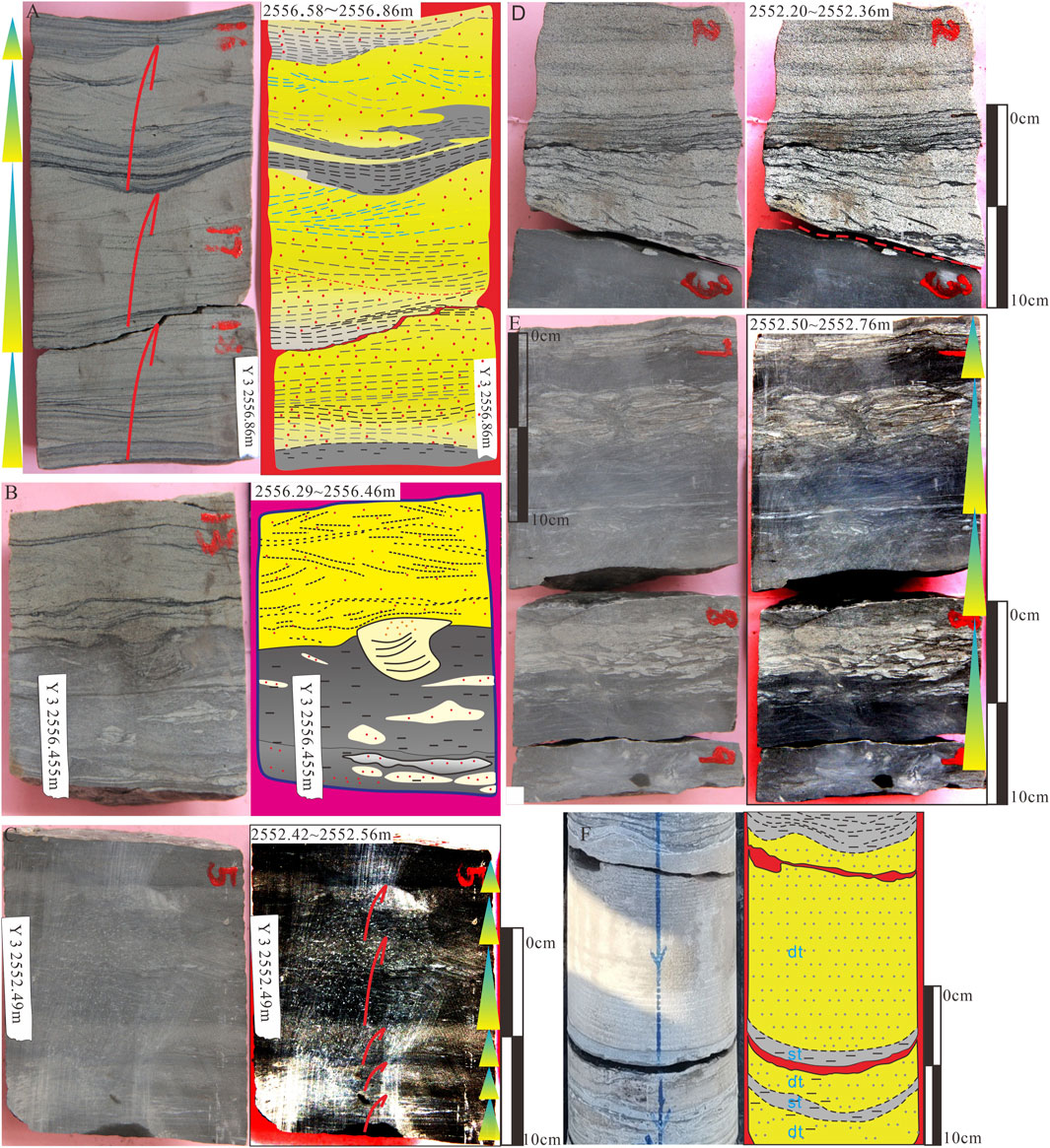
Figure 5. Atlas of typical facies marks in cores of well Y-3 and TG E−2, Ys Formation. (A) Core from well Y-3 with Medium to fine-grained sandstone interbedded with mudstone with bidirectional ripples and a core depth of 2,556.58–2,556.86 m. (B) Core from well Y-3 with sandstone and mudstone with bidirectional ripples, double mud drapes and a bioturbation structure and a core depth of 2,556.29–2,556.46 m. (C) Core from well Y-3 with Interbedded silty mudstone and argillaceous siltstone with upward-coarsing beddings and a core depth of 2,552.42–2,552.56 m. (D) Core from well Y-3 with fine sandstone with scouring surface, parallel bedding and clay rip-up clasts and a core depth of 2,552.20–2,552.36 m. (E) Core from well Y-3 with sandstone and mudstone and a core depth of 2,552.50–2,552.76 m. (F) Core from well T Ge-2 with sandstone and mudstone with bidirectional ripples, double mud drapes. Dt: Dominant tide. st: Slack tide.
4.2.1.1 Interpretation
This facies association was deposited in an environment with variable hydrodynamic energy. Lithofacies SF consists of sand-rich sediment, indicating a high-energy hydrodynamic environment. The variation in lamina thickness follows tidal rhythmites. These phenomena suggest the dominance of tidal action and reflect a subtidal environment. Lithofacies He-W exhibits periodic fluctuations in hydrodynamic energy strength and the deposition of alternating bed loads and suspended sediments, indicating an intertidal environment. Lithofacies MH reflects low-energy hydrodynamic conditions, supporting the survival and abundance of organisms under low environmental pressure, indicative of a supratidal environment. Therefore, lithofacies SF, He-W, and MH represent sand flat, mixed flat, and mud flat, respectively.
4.2.2 Tidal channel
The dominant lithofacies within this facies association is parallel bedding sandstone (SP). At the base of this facies association, there is a scouring surface. Below the scouring surface, silty mudstone was observed, overlain by parallel-bedded fine sandstone containing abundant clay rip-up clasts. The fine sandstone contains numerous intermittent or continuous argillaceous drapes (Figure 5D).
4.2.2.1 Interpretation
The deposition of this facies association occurred within a tidal hydrodynamic environment characterized by high energy. Evidences such as parallel bedding, scouring surface, presence of clay rip-up clasts, and distinct transitions from mud to sand indicate a significant rise in hydrodynamic intensity. The intermittent or continuous drapes observed within the fine sandstone represent suspended sediment deposits during slack tide. Based on these characteristics, this facies association is interpreted as a tidal channel. The juxtaposition of silty mudstone and parallel bedded mudstone signifies the overlapping relationship between the mud flat and the tidal channel, representing a transgressive succession.
4.3 Core section
The core of well Y-3 can be divided into three units (Figure 6). Unit I comprises predominantly fine sandstone and siltstone, with sporadic thin (cm) mudstone beds. Unit II is characterized by a dominance of silty mudstone and muddy siltstone in terms of lithology. Unit III consists mainly of fine sandstone, with scattered thin mudstone beds.
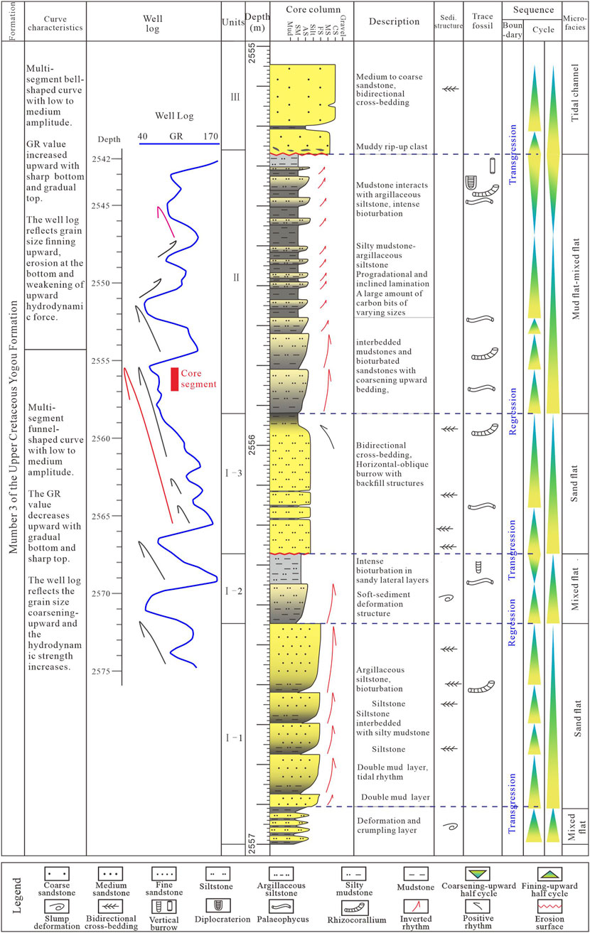
Figure 6. The comprehensive interpretation histogram of core facies (well Y-3, member three of Yogou formation).
The logging curve of the core section exhibits a consistent coarsening upward cycle. The core primarily displays the characteristics of transgressive cycles, while regressive successions are often limited due to erosion. The core sections, as a whole, consist of a sequence of mixed flat, sand flat, mixed flat, sand flat, mixed flat, mud flat, and tidal channel from bottom to top (Figure 6). Within these sections, the inversely graded lithofacies, formed by the overlay of mud flat, mixed flat, and sand flat, represent the transgressive succession. These lithofacies exhibit bidirectional cross-beddings, double mud drapes, and tidal rhythmites. Additionally, the tidal channel microfacies contains abundant clay rip-up clasts, indicating active erosion and deposition processes. (Figure 6).
4.4 Microscopic tidal sedimentary characteristics
Placing the core sample under a microscope for observation reveals significant tidal features. The fine sandstone within the sand flat microfacies shows the development of dominant tides (dt) and subordinate tides (st). These layers also contain double mud drapes, contributing to the spring-neap cycle characterized by a “thick-thin-thick” rhythm (Figures 7A, B). Figure 7C displays similar features, with more pronounced coarsening-upward and transgression. In tidal flat deposits, flaser bedding, wavy bedding and lenticular Bedding are typical in micrographs (Figure 8).
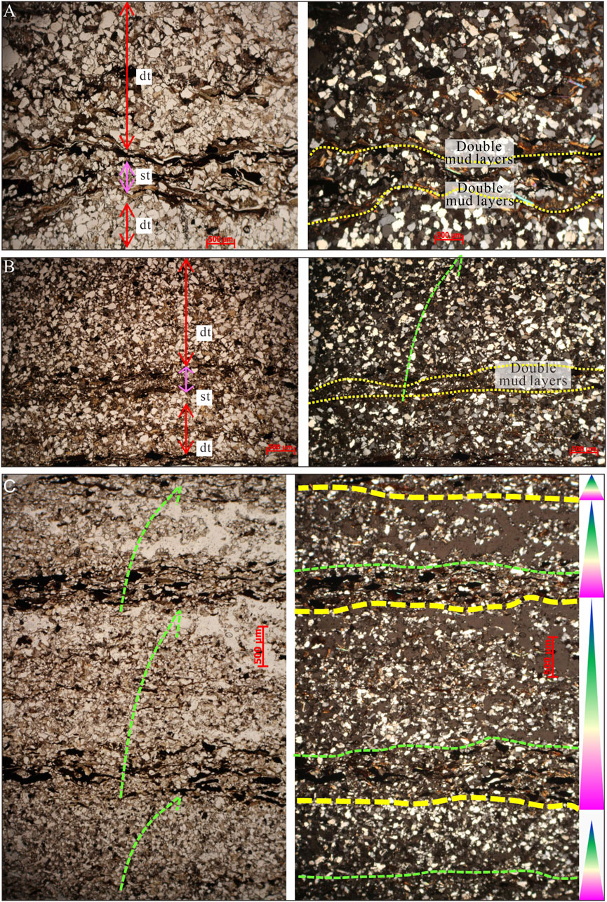
Figure 7. Thin sections of typical tidal flat facies, and the left and right figures of the same group are the single polarized photo and the cross-polarized photo respectively (well Y-3, member three of Yogou Formation). (A) Double mud drapes. (B) Double mud drapes. (C) Double mud drapes and upward-coarsing beddings.
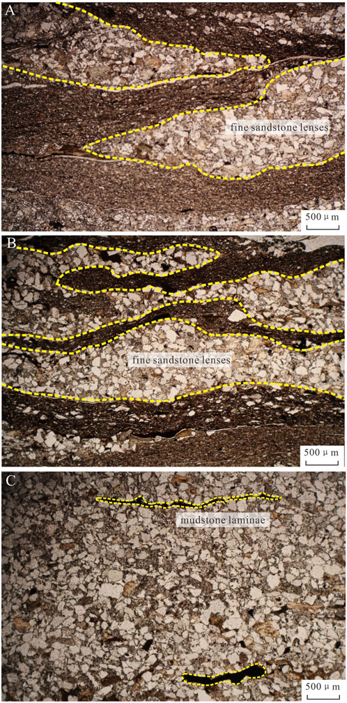
Figure 8. Thin sections of typical sedimentary structures of tidal flat facies, well Y-3. (A) Wavy interbedded sandstone and mudstone with fine sandstone lenses. (B) Mudstone with fine sandstone lenses. (C) Fine sandstone with discontinuous mudstone laminae.
Furthermore, the formation, transport, and settlement processes of fluid mud under tidal environments have been comprehensively demonstrated. Within the gray-black mudstone containing fine sand of the mud flat microfacies (Figure 9A), there are visible mudstone layers with siltstone lenses (Figure 9B). Instead of exhibiting a simple slackwater deposition, the mud displays cross-bedding structures. Bidirectional cross-bedding, scouring surfaces, and downlap interfaces are evident (Figures 9C–1, 9C-2), indicating the transportation and deposition of flocculent particles induced by tidal action. These characteristics suggest that the Y-3 well in the Upper Yogou Formation is located near a provenance with significant tidal energy. This core period is generally regressive, and the dominant facies consist of marine-terrigenous facies.
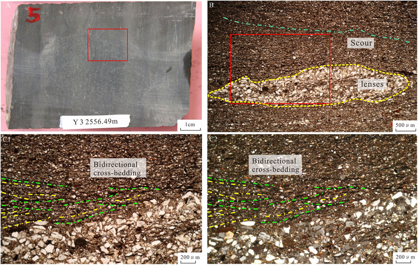
Figure 9. Core and thin sections of floating mud (fluid mud) deposit, well Y-3, depth 2,552.49 m. (A) Mudstone. (B) Mudstone with siltstone lenses. (C1, PPL; C2, XPL) Bidirectional ripples, scouring surfaces and downlap interfaces.
4.5 Characteristics of the Donga Formation under the microscope
The Donga Formation represents the first third-order sequence in the Termit Basin during the Late Cretaceous transgression, underlaid the Yogou Formation (Yuan et al., 2023). Although no coring was conducted in the Donga Formation of the Termit Basin, thin slice grinding with coring data from borehole wall shows rich fossil contents under the microscope (Figure 10). Bioclast-rich beds, bioclastic sandy mudstone (Figures 10A, B), and calcispheres (Figure 10C1, C2) were found in the Donga Formation. The application of scanning electron microscopy unveiled a significant number of calcareous foraminiferal tests within the muddy bioclastic limestone, with clay (kaolinite) commonly filling the interiors of the tests (Figures 10D, E). According to the stratigraphic division, these wall coring locations are located in the upper part of the Donga Formation of well Dw N-1 (Figure 1A). Well-loggings in dozens of wellsindicate the presence of a thin set of carbonate rocks (less than 2 m thick) at the upper section of the Donga Formation. These carbonate intervals consist predominantly of limestone, occasionally supplemented by dolomite, and exhibit abundant bioclastics, implying a locally clean water environment during the sedimentary period. The majority of these wells are positioned in proximity to the basin depression, away from the influence of provenance. Conversely, wells near the margin of the basin typically lack carbonate rocks at the top of the Donga Formation.
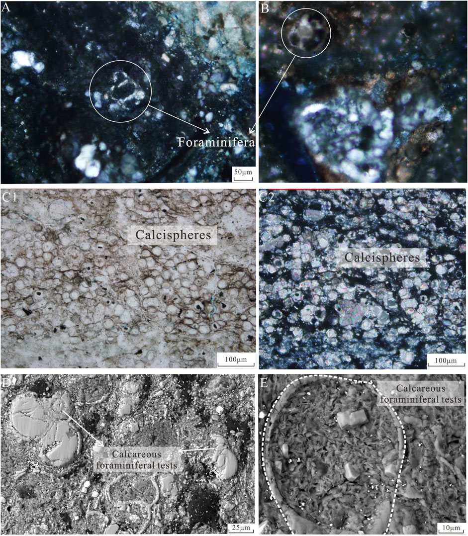
Figure 10. Atlas of typical fossil contents in thin sections. (A) Bioclastic sandy mudstone with foraminifera, well Dw N-1, depth 4039 m. (B) Bioclastic sandy mudstone with Foraminifera. (C1, PPL; C2, XPL) calcispheres, well Dw N-1, depth 4049 m. (D, E) Muddy bioclastic limestone with foraminifera calcareous tests and clay (kaolinite), well Dw N-1, depth 4049 m.
5 Discussions
The existence of the Late Cretaceous Saharan Seaway was initially a subject of debate. However, accumulating research and documentary evidence have now led to its acceptance (Reyment and Twit, 1972; Guiraud et al., 2005; Liu et al., 2011; Edegbai et al., 2019; Dou et al., 2022). Geographically, the Termit Basin is situated in the central region of this seaway. Despite this, there have been few studies on the direction and characteristics of its transgression, including the development of tides, the formation of carbonate rocks during the transgression, and the extent of the prototype basin. This section aims to address these topics.
5.1 Regional marine and tidal processes
In this paper, we conclude that the Late Cretaceous Termit prototype basin exhibited strong tidal conditions. Towards the south and southwest, the Termit prototype basin connects to the Atlantic Ocean through the Bornu-Benue Trough and Bida Basin (Figure 1A). The Bida Basin has revealed abundant Late Cretaceous marine or transgressive strata, with prominent marine and tidal facies indicators such as marine bivalves, dinoflagellates (Dinogymnium, Senegalinium and Spiniferites) and trace-fossil (Ophiomorpha and Thallasinoides), as well as herringbone cross-bedding, hummocky cross-bedding, and double mud drapes (Ojo and Akande, 2009).
In the Bornu-Benue Trough, the Kasade-1 well has discovered typical marine strata, containing ten types of planktonic foraminifera, echinoderms, fish fossils, and a large number of planktonic microbiomes (Ola et al., 2016). Additionally, numerous marine biomarkers have been identified (Adegoke et al., 2015). To the north, the Termit prototype basin is connected to Tethys by the Tenere basin and the extensive region of Algeria (Konaté et al., 2019). The size of Termit prototype basin is sufficiently large to generate strong tidal, wave, and current interactions, analogous to those observed in the North American “Cretaceous Western Seaway” (Allen and Posamentier, 1993; Varban and Guy Plint, 2008; Lin and Bhattacharya, 2020; Gardner and Dorsey, 2021).
5.2 Sedimentary environment of the upper Yogou Formation in Termit Basin
Previous studies indicate that during the early Cenomanian, seawater in the eastern Niger (including the Termit Basin, Tenere Basin, etc.) originated from the northern New Tethys Ocean. Towards the end of the Cenomanian, a connection was established with the South Atlantic Ocean, leading to transgression from two directions (Guiraud et al., 2005; Liu et al., 2011). Based on the findings of this study, it is concluded that the member Ys3 of the Upper Yogou Formation represents a marine-terrigenous environment under a regressive setting. The upper part of the Yogou Formation, specifically the member Ys3, predominantly consists of sand-mud interbedded deposits (Figure 3), aligning with the characteristics observed in the core section of well Y-3. During the depositional period of the member Ys3, the Yogou slope existed within a coastal sedimentary environment, primarily characterized by a gentle slope zone (Yuan et al., 2018). Analysis of the well Y-3 cores (Figure 5) reveals frequent fluctuations of transgression and regression. The transgressive succession demonstrates a relatively complete record, while the regressive succession is comparatively less developed. The cores exhibit fine grain size, diverse vertical facies successions, abundant sedimentary structures (such as bidirectional cross-bedding, ripple bedding, and bioturbation structures), and are dominated by coarsening-upward bedding, indicating the influence of various hydrodynamic processes during tidal cycles. This period coincides with the initiation of a global sea level fall from a high state and the commencement of seawater withdrawal from the Sahara Seaway (Guiraud et al., 2005; Edegbai et al., 2019). The deposits of this period were characterized by the predominance of remarkably thick mudstone, suggesting a significant supply of terrigenous material and a substantial accommodation space.
5.3 Discovery of tidal processes and discussion on the range of prototype basin
This paper presents a novel analysis of the late Cretaceous tidal processes in the Termit Basin based on core descriptions. In addition to the Y-3 core, data from the 1979 exploration well and the most recent coring well in 2022 were also collected, revealing similar sedimentary characteristics (Figure 5). The sedimentary environment of the basin in the member Ys3 period was mainly coastal, and the double mud drapes and the presence of bidirectional cross-bedding confirms the presence of tidal deposits rather than pelagic deposits in the late Cretaceous Termit Basin. It can be inferred that during periods of relatively high sea levels, such as the middle and late stages of the Donga Formation and member one to two of the Yogou Formation, tidal features likely developed along the basin margin due to the establishment of a unified regional water level, similar to the western edge of the Iullemeden Basin. The Termit Basin, positioned in the middle of the prototype basin, predominantly consists of mudstone, exhibiting less noticeable tidal characteristics. According to the available IHS(Information Handling Services) data and earlier literature, the Eastern Niger region and the surrounding basin, commonly referred to as the Chad Basin, encompass an area exceeding one million km2. Based on the outcrop study, Pascal et al. (1993) proposed that during the early and middle Late Cretaceous, the Iullemeden-East Niger Basin experienced a gradual deepening of its continental shelf slope in the eastern region. The western part of the Iullemeden Basin is a marine-terrigenous facies, which reflects the frequent alternation between marine and terrigenous deposits. In the eastern portion of the Iullemeden Basin, the proportion of clastic rocks progressively decreases, while the occurrence of glauconite, ammonite, and limestone beds increases. Moving further east, the deposition of clastic rocks is primarily observed in the Termit Basin. Consequently, it is imperative to redefine the extent of the prototype basin in the late Cretaceous Termit Basin.
5.4 Carbonate rocks in the Upper cretaceous Termit Basin and its oil-gas significance
In general, carbonate rocks tend to develop easily in transgressive systems tract and highstand systems tract. As mentioned earlier, analysis of logging data revealed the presence of a thin set of carbonate rocks, measuring 1–2 m in thickness, at the top of the Donga Formation in the Termit Basin and calcareous mudstone and calcareous siltstone dominate the middle and lower parts. Wells containing carbonate rocks are primarily situated near the basin depression, such as well Dw N-1 (Figures 1, 10), whereas wells with fewer carbonate rocks are relatively closer to the basin margin. This distribution pattern reflects the characteristics of the water environment and sediment supply in the following ways: firstly, there was no large-scale clean water environment formed in the Termit Basin during transgression; secondly, there was abundant sediment supply from various sources surrounding the basin; thirdly, the settlement and sedimentation rates were relatively high, precluding the development of extensive carbonate rocks. In addition, previous studies have shown that the South Tethyan Upper Cenomanian platforms developed in an arid climate, and unfavourable climatic conditions could prevent carbonate deposition, while also being influenced by hypersaline and anoxic events (Philip and Airaud-crumiere, 1991; Philip, 2003).
Previous studies on the Member Ys3 (the main source rock in the basin) indicated a terrestrial origin for its organic matter (Wan et al., 2014; Dou et al., 2022). This understanding has led to the discovery of several billion-ton oil field clusters in the Termit Basin. Facies analysis reveals that the sandstone percent near the basin margin will increase, giving rise to a greater occurrence of sandy interlayers within the extensive mudstone layers. Consequently, resemblances to member Ys3 will emerge in the lower part of these deposits. The widely distributed mudstone and sandstone sequences will become source rocks in a wider range, potentially giving rise to hydrocarbon reservoirs based on the material foundation of source rock development (Yuan et al., 2023). For instance, based on the recognition of the widespread Upper Cretaceous source rocks developed across the basin in this region, the future prospects of the eastern hydrocarbon enrichment zone of the Termit Basin remain highly promising (Yuan et al., 2023).
6 Conclusions
(1) This paper proposed the development of tidal processes in the Late Cretaceous Yogou Formation of the Termit Basin for the first time. Combining evidence from paleontological fossils, it was evident that the basin exhibited a superimposed marine sequence over the early Cretaceous continental sequence. The tidal flat sedimentary system comprised mud flat, mixed flat, sand flat, and tidal channel. It was concluded that during transgression, the tidal energy intensified, leading to the formation of high-frequency transgressive and regressive cycles dominated by reverse rhythm and tidal flat environments.
(2) This study discussed the position and sedimentary characteristics of the Termit Basin in the Late Cretaceous Saharan Seaway, and proposed that the prototype basin during the Late Cretaceous was much larger than its current extent. The wide paleogeography of the Late Cretaceous basin and its connectivity with seawater provided the necessary conditions for tidal process formation, updating the understanding of the sedimentary framework of Termit Basin.
(3) This study confirmed that the mudstone development range in the Late Cretaceous Termit Basin was broader than previously understood. Moreover, there may be viable source rocks in areas with lower exploration degrees in the eastern Termit Basin. This finding holds significant guidance for the evaluation of oil and gas potential as well as the exploration of new projects.
Data availability statement
The original contributions presented in the study are included in the article/supplementary material, further inquiries can be directed to the corresponding authors.
Author contributions
SY: Conceptualization, Data curation, Project administration, Visualization, Writing – original draft. CY: Software, Visualization, Writing – original draft. XZ: Investigation, Writing – review and editing. GZ: Investigation, Writing – review and editing. RS: Writing – review and editing. SC: Writing – review and editing. HW: Writing – review and editing. Hong Jiang: Writing – review and editing. YS: Writing – review and editing. JS: Writing – review and editing.
Funding
The author(s) declare that financial support was received for the research and/or publication of this article. Project of PetroChina, grant number 2023DQ0422. And it was also funded by the National Natural Science Foundation of China, grant number 42372131.
Acknowledgments
We would like to thank Professor Zhang Guangya, Professor Xiao Kunye, Professor Yuan Xuanjun from Research Institute of Petroleum Exploration and Development for their guidance and assistance in the paper. We also thank the International Science and Technology Cooperation Project of PetroChina (2023DQ0422) and the National Natural Science Foundation of China (42372131) for financial support.
Conflict of interest
Authors SY, XZ, HJ, and YS were employed by PetroChina. Author GZ was employed by China National Oil and Gas Exploration and Development Corporation.
The remaining authors declare that the research was conducted in the absence of any commercial or financial relationships that could be construed as a potential conflict of interest.
The reviewer SL declared a shared affiliation with the authors CY, HW to the handling editor at time of review. The authors declare that this study received funding from PetroChina. The funder had the following involvement in the study: data collection.
Generative AI statement
The author(s) declare that no Generative AI was used in the creation of this manuscript.
Publisher’s note
All claims expressed in this article are solely those of the authors and do not necessarily represent those of their affiliated organizations, or those of the publisher, the editors and the reviewers. Any product that may be evaluated in this article, or claim that may be made by its manufacturer, is not guaranteed or endorsed by the publisher.
References
Adegoke, A. K., Abdullah, W. H., Hakimi, M. H., and Sarki Yandoka, B. M. (2015). Geochemical characterisation and organic matter enrichment of Upper Cretaceous Gongila shales from Chad (Bornu) Basin, northeastern Nigeria: bioproductivity versus anoxia conditions. J. Petroleum Sci. Eng. 135, 73–87. doi:10.1016/j.petrol.2015.08.012
Allen, G. P., and Posamentier, H. W. (1993). Sequence stratigraphy and facies model of an incised valley fill: the Gironde Estuary, France. J. Sediment. Res. 63 (3), 378–391. doi:10.1586/14737140.2014.883283
Binks, R. M., and Fairhead, J. D. (1992). A plate tectonic setting for Mesozoic rifts of West and Central Africa. Tectonophysics 213, 141–151. doi:10.1016/0040-1951(92)90255-5
Catuneanu, O. V., Abreu, J. P., Bhattacharya, M. D., Blum, R. W., Dalrymple, P. G., Eriksson, C. R., et al. (2009). Towards the standardization of sequence stratigraphy. Earth-Science Rev. 92, 1–33. doi:10.1016/j.earscirev.2008.10.003
Dou, L. R., Bai, G. S., Liu, B., Zhai, G. H., Zhang, X. X., Zhang, Y. Y., et al. (2022). Sedimentary environment of the upper cretaceous Yogou Formation in Termit Basin and its significance for high-quality source rocks and trans-saharan seaway. Mar. Petroleum Geol. 142, 105732. doi:10.1016/j.marpetgeo.2022.105732
Edegbai, A. J., Schwark, L., and Oboh-Ikuenobe, F. E. (2019). A review of the latest Cenomanian to Maastrichtian geological evolution of Nigeria and its stratigraphic and paleogeographic implications. J. Afr. Earth Sci. 150, 823–837. doi:10.1016/j.jafrearsci.2018.10.007
Fairhead, J. D., and Green, C. M. (1989). Controls on rifting in Africa and the regional tectonic model for the Nigeria and East Niger rift basins. J. Afr. Earth Sci. (and the Middle East) 8, 231–249. doi:10.1016/S0899-5362(89)80027-2
Gardner, K., and Dorsey, R. J. (2021). Mixed carbonate-siliciclastic sedimentation at the margin of a late Miocene tidal strait, lower Colorado River Valley, south-western USA. Sedimentology 68 (5), 1893–1922. doi:10.1111/sed.12834
Gebhardt, H. (1998). Foraminifera from the Maastrichtian lower Mamu Formation near Leru (southern Nigeria): Paleoecology and paleogeographic significance. J. Foraminifer. Res. 28 (1), 76–89.
Genik, G. J. (1992). Regional framework, structural and petroleum aspects of rift basins in Niger, Chad and the Central African Republic (C.A.R.). Tectonophysics 213 (1-2), 169–185. doi:10.1016/B978-0-444-89912-5.50036-3
Genik, G. J. (1993). Petroleum geology of cretaceous-tertiary rift basins in Niger, Chad and Central African Republic. AAPG Bull 77 (8), 1405–1434. doi:10.1306/bdff8eac-1718-11d7-8645000102c1865d
Guiraud, R., Bosworth, W., Thierry, J., and Delplanque, A. (2005). Phanerozoic geological evolution of northern and central Africa: an overview. Journal of African Earth Sciences 43 (1-3), 83–143. doi:10.1016/j.jafrearsci.2005.07.017
Guiraud, R., and Maurin, J. C. (1992). Early cretaceous rifts of western and central Africa: an overview. Tectonophysics 213, 153–168. doi:10.1016/0040-1951(92)90256-6
Haq, B. U. (2014). Cretaceous eustasy revisited. Global and Planetary Change 113, 44–58. doi:10.1016/j.gloplacha.2013.12.007
Harouna, M., and Philp, R. P. (2012). Potential petroleum source rocks in the Termit basin, Niger. Journ. Petrol. Geol. 35 (2), 165–185. doi:10.1111/j.1747-5457.2012.00524.x
Harouna, M., Pigott, J. D., and Philp, R. P. (2017). Burial history and thermal maturity evolution of the Termit Basin, Niger. Journal of Petroleum Geology 40 (3), 277–297. doi:10.1111/jpg.12676
Kogbe, C. A. (1981). Cretaceous and tertiary of the iullemmeden Basin in Nigeria (West Africa). Cretaceous Research 2 (2), 129–186. doi:10.1016/0195-6671(81)90007-0
Konaté, M., Ahmed, Y., and Harouna, M. (2019). Structural evolution of the Téfidet trough (East Aïr, Niger) in relation with the West African Cretaceous and Paleogene rifting and compression episodes. Comptes Rendus Geoscience 351 (5), 355–365. doi:10.1016/j.crte.2018.11.009
Lin, W., and Bhattacharya, J. P. (2020). Depositional facies and the sequence stratigraphic control of a mixed-process influenced clastic wedge in the Cretaceous Western Interior Seaway: the Gallup System, New Mexico, USA. Sedimentology 67 (2), 920–950. doi:10.1111/sed.12667
Liu, B., Pan, X. H., Wan, L. K., Mao, F. J., Liu, J. G., Lü, M. S., et al. (2011). Marine transgression of the eastern Niger Basin in the late cretaceous: paleontological and geochemical evidences. Geoscience 25 (5), 995–1006. (in Chinses with English abstract). doi:10.3969/j.issn.1000-8527.2011.05.020
Liu, B., Wan, L. K., Mao, F. J., Liu, J. G., Lü, M. S., and Wang, Y. H. (2015). Hydrocarbon potential of upper cretaceous marine source rocks in the Termit Basin, Niger. Journal of Petroleum Geology 38 (2), 157–175. doi:10.1111/jpg.12604
Liu, B., Zhang, G., Mao, F., Liu, J., and Liu, M. (2017). Geochemistry and origin of upper cretaceous oils from the Termit Basin, Niger. Journal of Petroleum Geology 40 (2), 195–207. doi:10.1111/jpg.12672
Liu, J., Zhang, G., Li, Z., Tang, Y., Xiao, H., Lai, H., et al. (2019). Oil charge history of paleogene-eocene reservoir in the Termit Basin (Niger). Australian Journal of Earth Sciences 66 (4), 597–606. doi:10.1080/08120099.2019.1568301
Liu, J. G., Cheng, J. H., Zhang, G. Y., Mao, F. J., and Yang, N. (2020). Cretaceous dinoflagellate cyst biostratigraphy in the Facai-1 well of the Tenere Graben in eastern Niger, Africa. Journal of African Earth Sciences 169, 103888. doi:10.1016/j.jafrearsci.2020.103888
Liu, J. G., Zheng, F. Y., Mao, F. J., Jiang, H., Li, Z. H., Lü, M. S., et al. (2022). Reservoir characteristics and its controlling factors of the Paleogene Sokor1 Formation in Termit Basin, Niger. Acta Petrologica Sinica 38, 2581–2594. (in Chinses with English abstract). doi:10.18654/1000-0569/2022.09.04
Lü, M. S., Xue, L. Q., Su, Y. D., Wan, L. K., Mao, F. J., Liu, J. G., et al. (2012). Rifting controls on sequence stratigraphic architecture: a case study in the lower cretaceous of Termit Basin, West African Rift System. Journal of Jilin University (Earth Science Edition) 42 (3), 647–656. (in Chinses with English abstract). doi:10.1007/s11783-011-0280-z
Mansour, A., Wang, J., Fu, X. G., Tahoun, S. S., and Ruebsam, W. (2024). Regional to global correlation of Cenomanian-early Turonian sea-level evolution and related dynamics: new perspectives. Earth-Science Reviews 256, 104863. doi:10.1016/j.earscirev.2024.104863
Mao, F. J., Liu, B., Liu, J. G., Jiang, H., Yuan, S. Q., Zheng, F. Y., et al. (2019). The reservoir characteristics and controlling factors of the Upper Cretaceous sandstones in the Termit Basin, Niger. Acta Petrologica Sinica 35 (4), 1257–1268. (in Chinses with English abstract). doi:10.18654/1000-0569/2019.04.18
Mao, F. J., Liu, J. G., Jiang, H., Yuan, S. Q., Li, Z. M., Zheng, F. Y., et al. (2020). Diagenesis of Cretaceous sandsond and prediction of favorable reservoir development area in the Termit Basin of the West African rift system. China Petroleum Exploration 25, 86–94. (in Chinses with English abstract). doi:10.3969/j.issn.1672-7703.2020.04.009
Mao, F. J., Liu, R. H., Liu, B., Jiang, H., Liu, J. G., Wang, X. Y., et al. (2016). Palaeogeographic evolution of the upper cretaceous in Termit Basin and its adjacent areas, Niger. Earth Science Frontiers 23 (3), 186–197. (in Chinses with English abstract). doi:10.13745/j.esf.2016.03.023
Meister, C., Alzouma, K., Lang, J., Mathey, B., and Pascal, A. (1994). New data on the ammonite faunas from eastern Niger (Tenere, Western Africa) during the Cenomanian-Turonianmarine transgression. Geobios 27 (2), 189–219. doi:10.1016/S0016-6995(94)80006-5
Mitchum, R., Vail, P. R., and Sangree, J. B. (1977). “Seismic stratigraphy and global changes of sea level, part 6: stratigraphic interpretation of seismic reflection patterns in depositional sequences,” in Seismic stratigraphy - applications to hydrocarbon exploration. Editor C. E. Payton (America: American Association of Petroleum Geologists, Memoir), 26, 117–133. doi:10.1306/M26490C8
Moody, R. T. J., and Sutcliffe, P. J. C. (1991). The cretaceous deposits of the iullemmeden basin of Niger, central West Africa. Cretaceous Research 12 (2), 137–157. doi:10.1016/S0195-6671(05)80021-7
Müller, R. D., Sdrolias, M., Gaina, C., Steinberger, B., and Heine, C. (2008). Long-term sea-level fluctuations driven by ocean basin dynamics. Science 319, 1357–1362. doi:10.1126/science.1151540
Ojo, O. J., and Akande, S. O. (2009). Sedimentology and depositional environments of the maastrichtian Patti Formation, southeastern Bida Basin, Nigeria. Cretaceous Research 30 (6), 1415–1425. doi:10.1016/j.cretres.2009.08.006
Ola, P. S., Adekoya, J. A., and Olabode, S. O. (2016). Late cretaceous/early paleocene biostratigraphy of the northern portion of the Bornu Basin, Nigeria. Open Journal of Geology 6 (7), 561–570. doi:10.4236/ojg.2016.67044
Pascal, A., Mathey, B., Alzouma, K., Lang, J., and Meister, C. (1993). Late Cenomanian-early Turonian shelf ramp, Niger, West Africa. Tulsa: Am. Assoc. Pet. Geol. Mem., 56, 145–154. doi:10.1306/M56578C12
Philip, J. (2003). Peri-Tethyan neritic carbonate areas: distribution through time and driving factors. Palaeogeography, Palaeoclimatology, Palaeoecology 196 (1–2), 19–37. doi:10.1016/S0031-0182(03)00311-0
Philip, J. M., and Airaud-Crumiere, C. (1991). The demise of the rudist-bearing carbonate platforms at the Cenomanian/Turonian boundary: a global control. Coral Reefs 10, 115–125. doi:10.1007/BF00571829
Reyment, R. A. (1980). Biogeography of the saharan gretaceous and paleocene epicontinental transgressions. Cretaceous Research 1 (4), 299–327. doi:10.1016/0195-6671(80)90041-5
Reyment, R. A., and Twit, E. A. (1972). Biostratigraphical dating of the early history of the South Atlantic Ocean. Philosophical Transactions of the Royal Society of London. Series B Biological Sciences 264 (858), 55–95. doi:10.1098/rstb.1972.0009
Taylor, A. M., and Goldring, R. (1993). Description and analysis of bioturbation and ichnofabric. Journal of the Geological Society 150, 141–148. doi:10.1144/gsjgs.150.1.0141
Varban, B. L., and Guy Plint, A. (2008). Palaeoenvironments, palaeogeography, and physiography of a large, shallow, muddy ramp: late Cenomanian-Turonian Kaskapau Formation, Western Canada foreland basin. Sedimentology 55 (1), 201–233. doi:10.1111/j.1365-3091.2007.00902.x
Wan, L. K., Liu, J. G., Mao, F. J., Lv, M. S., and Liu, B. (2014). The petroleum geochemistry of the Termit Basin, eastern Niger. Marine and Petroleum Geology 51, 167–183. doi:10.1016/j.marpetgeo.2013.11.006
Xiao, H., Wang, T. G., Li, M., Lai, H., Liu, J., Mao, F. J., et al. (2019). Geochemical characteristics of Cretaceous Yogou Formation source rocks and oil-source correlation within a sequence stratigraphic framework in the Termit Basin, Niger. Journal of Petroleum Science and Engineering 172, 360–372. doi:10.1016/j.petrol.2018.09.082
Yuan, S. Q., Dou, L. R., Cheng, D. S., Mao, F. J., Pan, C., Zheng, F. Y., et al. (2023). New understanding and exploration direction of hydrocarbon accumulation in Termit Basin, Niger. Petroleum Exploration and Development 50, 268–280. (in Chinses with English abstract). doi:10.1016/s1876-3804(23)60386-6
Yuan, S. Q., Mao, F. J., Zheng, F. Y., Zhang, G. Y., Liu, J. G., Lü, M. S., et al. (2018). Analysis of hydrocarbon accumulation condition and exploration tactics of the Upper Cretaceous strata in the Termit Basin, Niger. Earth Science Frontiers 25 (2), 42–50. (in Chinses with English abstract). doi:10.13745/j.esf.yx.2017-12-1
Zaborski, P. M., and Morris, N. J. (1999). The late cretaceous ammonite genus Libycoceras in the iullemmeden basin (West Africa) and its palaeogeographical significance. Cretaceous Research 20 (1), 63–79. doi:10.1006/cres.1998.0135
Zaoui, D., Meister, C., Benyoucef, M., Bensalah, M., Piuz, A., Tchenar, S., et al. (2018). Cenomanian-turonian ammonite successions in the tinrhert basin (southeastern Algeria): revision and new data. Cretaceous Research 88, 337–374. doi:10.1016/j.cretres.2017.09.011
Keywords: Niger, Termit Basin, Late Cretaceous, tidal flat, sedimentary system, seaway
Citation: Yuan S, Yu C, Zhang X, Zhai G, Steel RJ, Chen S, Wang H, Jiang H, Song Y and Song J (2025) Tidal-influenced transgression processes in late cretaceous Termit Basin, Niger. Front. Earth Sci. 13:1536608. doi: 10.3389/feart.2025.1536608
Received: 29 November 2024; Accepted: 26 May 2025;
Published: 10 June 2025.
Edited by:
Jiawang Ge, Southwest Petroleum University, ChinaReviewed by:
Natasha Khan, Abbottabad University of Science and Technology, PakistanHaiteng Zhuo, Sun Yat-sen University, China
Omar A. M. Mohammad, University of Kirkuk, Iraq
Shunli Li, China University of Geosciences, China
Copyright © 2025 Yuan, Yu, Zhang, Zhai, Steel, Chen, Wang, Jiang, Song and Song. This is an open-access article distributed under the terms of the Creative Commons Attribution License (CC BY). The use, distribution or reproduction in other forums is permitted, provided the original author(s) and the copyright owner(s) are credited and that the original publication in this journal is cited, in accordance with accepted academic practice. No use, distribution or reproduction is permitted which does not comply with these terms.
*Correspondence: Si Chen, c2ljaGVuNzIwQGhvdG1haWwuY29t; GuangHua Zhai, emhhaWd1YW5naHVhQGNucGNpbnQuY29t