 Sheng Li
 Yuanhua Qing2*
 Nannan Lu
- 1Yunnan Earthquake Agency, Kunming, China
- 2Centre for Southeast Asian Economy and Culture Studies, Chengdu Normal University, Chengdu, China
- 3College of Earth and Planetary Sciences, Chengdu University of Technology, Chengdu, China
- 4Sichuan Earthquake Agency, Chengdu, China
This paper extracted the fifth-level river system and 158 sub-basins in the middle and upper reaches of the Yunnan section of the Lancang River based on the ASTER GDEM data with a resolution of 30 m and ArcGIS software. By calculating relief, slope, hypsometric integral (HI), basin shape index (BS), stream length-gradient index (SL), and geomorphic information entropy of each sub-basin, and comprehensively considering rainfall, rock strata, and tectonics, this paper discusses the geomorphic features and tectonic significance of the middle and upper reaches of the Yunnan section of the Lancang River Basin. The research shows that: The middle and upper reaches of Yunnan section of the Lancang River Basin is in its middle age. The sub-basin shapes are mainly circular and square. The secondary river systems in the upper reaches are in the vertical drainage stage, while the secondary river systems in the middle reaches are still in the longitudinal drainage stage. The distributions of relief, slope, HI, SL, and BS are mainly controlled by tectonic activities, and the influences of rock strata and rainfall on the geomorphology are limited. In the areas of Jianchuan-Eryuan-Yangbi-Dali and the southern section of the middle reaches of the Lancang River, the tectonic uplift has stagnated and evolved into the erosion-deposition stage. The southern part of Deqin County and the southern part of Weixi County are in the uplift stage, while the tectonic uplift in the areas of Yunlong-Yongping-Luning has entered the attenuation stage. In the study area, the activity intensities of the Lanping-Yongping fault and the Weixi-Qiaohou fault are higher in the northern section and lower in the southern section. The Lancangjiang fault has a low activity intensity at the “S”-shaped big bend, while the tectonic activity in the northern section is strong. However, the tectonic activity in the southern section of the Longpan-Qiaohou fault and the northeastern section of the Nantinghe fault are weak. On the whole, the fault within the region have a controlling effect on the flow direction of the main river channel, and the patterns of the river system and the flow direction of the river channel are macroscopic responses to the tectonic uplift and lateral deformation.
1 Introduction
The Lancang River originates from the western side of Chagar Rima in the northern foothills of the Tanggula Mountains on the Tibetan Plateau, flows though Qinghai, Tibet, and Yunnan provinces of China, and is known as the Mekong River after its outbound journey, which flows through Myanmar, Laos, Thailand, Cambodia, and Vietnam, and is injected into the South China Sea southwest of Saigon City, Vietnam, making it Asia’s largest international river (Wang et al., 2005; Zhao et al., 2018). Among them, the Lancang River is characterized by north-south meandering and east-west spreading in Yunnan Province, with a large drop. There a valley elevation of 2,248 m at the entry point and 480 m at the exit point, and a main channel drop of 1,768 min Yunnan Province (Wang et al., 2005). The Lancang River Basin in Yunnan Province, with strong crustal deformation (Li et al., 2014) and complex internal geotectonics, is not only traversed by block boundary fractures such as the Lancangjiang fault and the Weixi-Qiaohou fault, but also by the Lanping-Yongping fault, the Nantinghe fault, and the Longpang-Qiaohou fault, and other internal sub-fractures outcropping (An et al., 2018). It has always been a hot spot for the study of neotectonic activities (Tang et al., 2013; Tan, 2014; Ji et al., 2015; Chang et al., 2022). However, studies related to tectonic geomorphology are mainly limited to macroscopic geomorphic factors such as slope, slope direction, and relief (Wang et al., 2005; Gan and Yuan, 2005; He et al., 2013) and small spatial scale hypsometric integral studies (Chang, 2021; Liu et al., 2023), Therefore, the geomorphic features and tectonic significance of the Yunnan section of Lancang River Basin are still unclear, and the study between the tectonic uplift and deformation and the water system in the medium-large spatial scale is even more lacking in the Yunnan section of Lancang River.
In recent years, in addition to being applied in disaster assessment (Taib et al., 2024), The Digital Elevation Model (DEM) and ArcGIS software analysis have also been widely used in the research of geomorphic parameters. They have overcome the limitations of qualitative geomorphic analysis and enabled semi-quantitative and quantitative research on geomorphology. Among these, the research on hypsometric integral (HI), stream length-gradient index (SL), basin shape index (BS), relief and slope is relatively extensive and has achieved favorable results. For example, Guo and Li (2024) pointed out the generation time sequence of the Taiwan Island orogenic belt based on hypsometric index, relief, and slope. Wang et al. (2022) quantified the tectonic strength based on the HI, SL, and BS, and redefined the late Cenozoic deformation mechanism in central Yunnan Province. Hadji et al. (2024) studied the relative tectonic activity in the Setifian Highlands region based on the hypsometric integral and stream length-gradient index.
The vegetation in the Lancang River Basin in Yunnan Province is well-developed, which makes it difficult to carry out geological field surveys. Moreover, there is a lack of continuous and large-scale Cenozoic sediments. Therefore, there are limitations in analyzing the characteristics of neotectonic activities in this area from the perspectives of river terraces and fault sections (Lee and Tsai, 2010). However, using tectonic geomorphology research can not only fully consider the geomorphic development process of the entire basin, but also quantify the tectonic activities on a long-time scale (Lee and Tsai, 2010). Previous studies have also pointed out that fluvial geomorphology, mountain geomorphology, and water systems can respond well to the uplift of the plateau (Loreto and Gerardo, 2014; Liu et al., 2018; Li et al., 2021). The Lancang River water system in Yunnan Province is well-developed and close to the Qinghai-Tibet Plateau, and the geomorphic characteristics of its basin have detailed records of the uplift process of the plateau under the background of neotectonic movement (Pan et al., 2000). Therefore, analyzing the geomorphic features of the middle and upper reaches of the Yunnan section of the Lancang River Basin is of great significance for evaluating the intensity of tectonic activities within the basin and comprehensively understanding the tectonic activities and geomorphic evolution in the western Yunnan region and even in the southeastern margin of the Qinghai-Tibet Plateau.
2 Geologicaland setting
The fluvial geomorphology of the Lancang River in Yunnan Province is diversified, which can be categorized as the upper reaches from the entrance of Tibet to Yunnan to Gongguoqiao, the middle reaches from Gongguoqiao to Jinglinqiao, and the lower reaches from Jinglinqiao to the exit point (Liu et al., 1998). As shown in Figure 1A, the scope of the study area in this paper mainly covers the regions within Diqing Prefecture and Lincang City, which are located in the upper and middle reaches of the Lancang River in the Yunnan section. It is composed of the main stream of the Lancang River, as well as the Bi River, the Yangbi River and the Luozha River (Figure 1B). In this area, sandstone, mudstone and conglomerate are mainly exposed. Secondly, there are gneiss, leptynite, slate, phyllite, as well as granite and monzogranite. The exposure of sand, mud and clay sediments is the least. The faults developed within the river basin are the following (An et al., 2018):
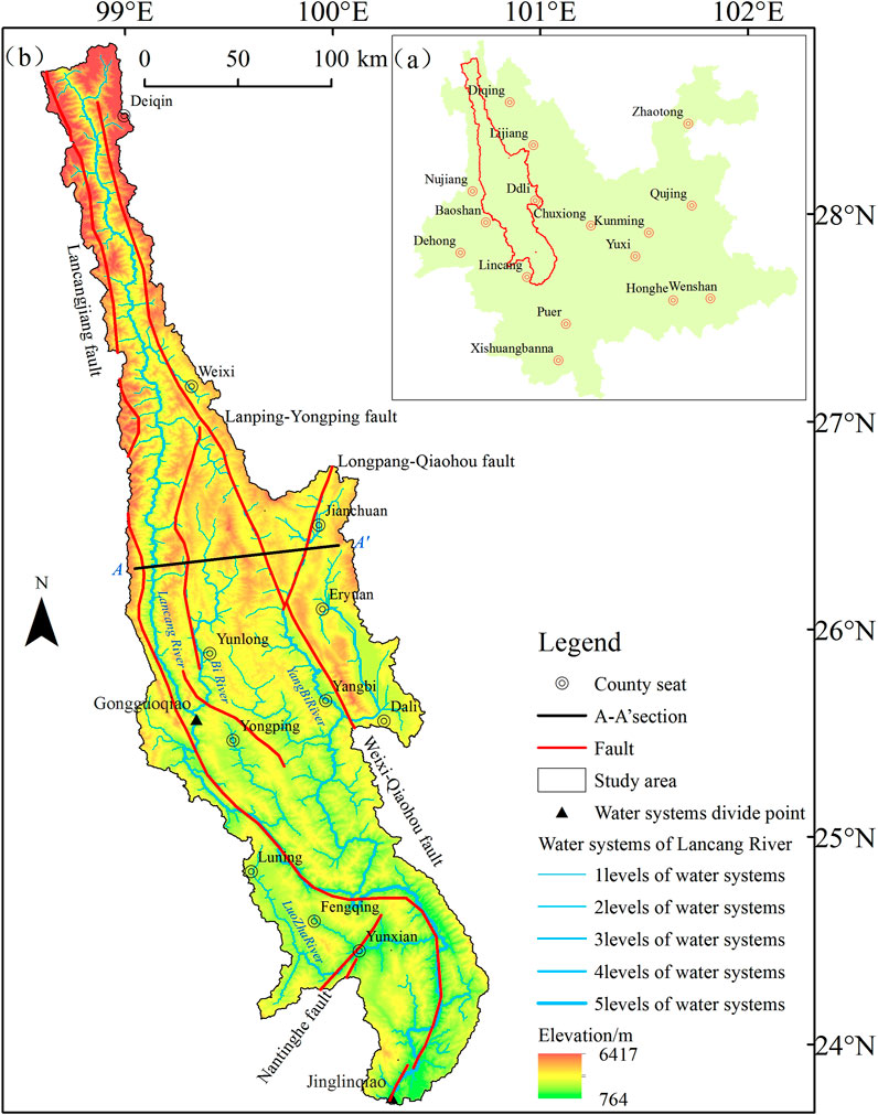
Figure 1. Location (a) and Tectonic-geomorphic map (b) of the study area.
The Lancangjiang fault: It is a reverse fault, and its latest active period is the Middle Pleistocene.
The Lanping-Yongping fault: It is a dextral strike-slip fault, and its latest active period is the Middle Pleistocene.
The Weixi-Qiaohou fault: It is a dextral strike-slip fault, and its latest active period is the Holocene.
The Nantinghe fault: It is a dextral strike-slip fault, and its active period is the Holocene.
The Longpan-Qiaohou fault: It is a sinistral strike-slip fault, and its active period is the Holocene.
The climate difference is obvious, from the upstream to the middle reaches of the river, which contains the frigid, temperate and subtropical climates, and the rainfall decreases from the upstream to the downstream.
3 Methodology and data
Digital elevation model (DEM) provides basic data for quantitative geomorphological analysis, and in this paper, we adopt the Global Digital Elevation Model introduced by National Aeronautics and Space of the United States in 2009, which covers the range of 83°N to 83°S and 99% of the Earth’s land surface, with a spatial resolution of 30 m, which can well extract geomorphological parameters (Fan et al., 2018). Rainfall data were obtained from the China Meteorological Data Network (http://data.cma.cn/site/index.html). Stratigraphic data were obtained from the vectorized 1:250,000 geological map of Yunnan Province. Active fractures were vectorized from Yunnan Quaternary Active Fracture Distribution Map (An et al., 2018) with a scale of 1:1 million.
As shown in Figure 2, first of all, based on the DEM data, we completed the extraction of the river system through hydrological analysis on the ArcGIS10.2 software platform. Then, we corrected the river system several times according to the Google Earth images to determine the flow threshold value, so as to complete the extraction of the fifth-level river system. Subsequently, based on the fifth-level river system, through processing procedures such as converting breakpoints into points and watershed analysis, we completed the extraction of 158 sub-basins (Figure 3). Finally, by calculating topographic relief, slope, hypsometric integral, basin shape index, stream length-gradient index, and entropy of geomorphic information of each sub-basin, we comprehensively analyzed the characteristics of tectonic landforms. And we combined with the research results of predecessors to verify the indicative significance of the basin landforms. Now, each parameter is introduced as follows:
(a) Hypsometric integral
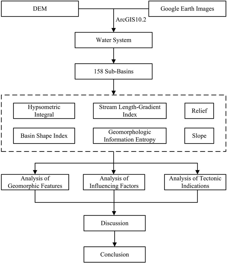
Figure 2. Flow chart of research methods.
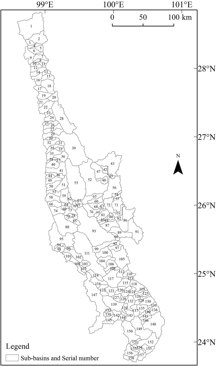
Figure 3. Distribution map of sub-basins in the study area.
HI was proposed by Strahler (1952), represents the proportion of volume remaining in the catchment basin under erosion, and is a parametric indicator of geomorphic erosion. Among them, HI < 0.35 indicates that the stage of geomorphologic development reaches the old age; 0.35<HI < 0.60 indicates that the geomorphologic development is in the middle age; HI > 0.60 indicates that the geomorphologic development is in the young age. There are three calculation methods: integral curve method, volume ratio method and undulation ratio method, of which the undulation ratio method is the most convenient (Chang et al., 2015), and the calculation formula is (Pike and Wilson, 1971):
Where Hmean is the average value of watershed elevation, and Hmax and Hmin represent the maximum and minimum elevation of the watershed, respectively. The mean, maximum and minimum values in the basin elevation of each basin were extracted using the partition statistics tool in ArcGIS, and the HI values of each sub-basin were calculated sequentially according to the public notice (1).
(b) Stream length-gradient index (SL)
SL is the local stream gradient multiplied by the distance of the center of the stream segment from the river source, which reflects the resistance of rocks to erosion and tectonic activity, and is calculated by the formula (Hack, 1973):
where Δh is the difference in elevation of the reach, ΔL is the length of the reach, Δh/ΔL is the slope of the reach, and L is the length from the watershed to the midpoint of the reach. Chang (2014) proposed a method for extracting this parameter, and in this study, the method of ΔL fixation was used, i.e., the river channel was divided by equal spacing, and then the elevations of the two vertices were used to calculate the SL value of the unit segment one by one by using Equation 2, and finally, the mean value of the SL of the segment was used to represent the size of the length gradient in each sub-watershed.
(c) Basin shape index (BS)
BS is the ratio of the straight-line distance from the source of the river valley in the drainage basin to the water outlet to the maximum width of the drainage basin perpendicular to this straight-line distance. It can indirectly reflect the intensity of tectonic activities, and the calculation formula is (Cannon, 1976):
Where: BI denotes the straight-line distance from the source to the outlet; BW denotes the maximum width of the watershed basin perpendicular to BI. The smaller the value of BS, the closer the shape of the watershed is to a circle, and vice versa, the larger the value of BS, the closer the shape of the watershed is to a narrow elongated shape. In the first stage, the river develops with the topographic slope of the mountain or the shape of the fault, and its own shape is linear, but in the later stage, due to the lateral erosion of the river, the basin shape tends to be rounded (Wang et al., 2022). This parameter was extracted according to the method of Peng (2014) and calculated using Equation 3.
(d) Topographic slope
Slope indicates the degree of inclination of a slope, reflecting the degree of denudation and accumulation of surface materials, and can indicate the development stage and degree of development of geomorphology (Guo and Li, 2024). This parameter was first calculated using the 3D analysis module in ArcGIS, and then the average slope information of each sub-watershed was extracted by the regional statistics module (Wang et al., 2017).
(e) Topographic relief
Topographic relief is a macroscopic topographic factor that quantifies the topographic changes of a region by the difference between the altitude of the highest point and that of the lowest point. It can directly reflect the degree of ground erosion and indirectly reflect the intensity of tectonic activities (Li et al., 2019). Its calculation formula is:
Where R represents the topographic relief, Hmax represents the maximum elevation, and Hmin represents the minimum elevation. Use the zonal statistics tool in ArcGIS to extract the maximum and minimum values of the elevation in each sub-watershed, and calculate them sequentially according to formula 4.
(f) Geomorphologic information entropy
The geomorphic information entropy, which indicates the strength of the internal and external geologic camping forces against the action, where the formula is calculated as (Ai et al., 1987; Ai and Yue, 1988):
Where H is the entropy value and S is the HI value, the smaller the value of H, the stronger the intensity of the internal and external geologic camping force antagonism. Based on formula 1, this parameter is used to calculate the geomorphic information entropy values of each drainage basin in combination with formula 5, and then the distribution map of entropy values in the study area is obtained based on spatial interpolation.
4 Results
4.1 Hypsometric integral
As shown in Table 1, the values of the HI range from 0.14 to 0.66. Among them, the sub-basins with HI values less than 0.35 are mainly concentrated on the north side of the southern segment of the Weixi-Qiaohou fault (68, 71, 77, 82, 84, 86, 87, 89, 91 sub-basins), the southern segment of the Lancangjiang fault (154, 157 sub-basins), both sides of the Nantinghe fault (134, 138, 142 sub-basins), and both sides of the Longpan-Qiaohou fault (42, 43, 45, 47, 56 sub-basins). Sub-basins with HI values greater than 0.6 are sporadically found in the north-central section of Lancangjiang fault (10,101 sub-basins), the north section of the Lanping-Yongping fault (51 sub-basins), and the north-central section of the Weixi-Qiaohou fault (20 sub-basins). The largest number of sub-basins have HI values between 0.35 and 0.6. As shown in Figure 4A, the values of the HI exhibit the characteristics of being higher in the north than in the south and higher in the west than in the east.
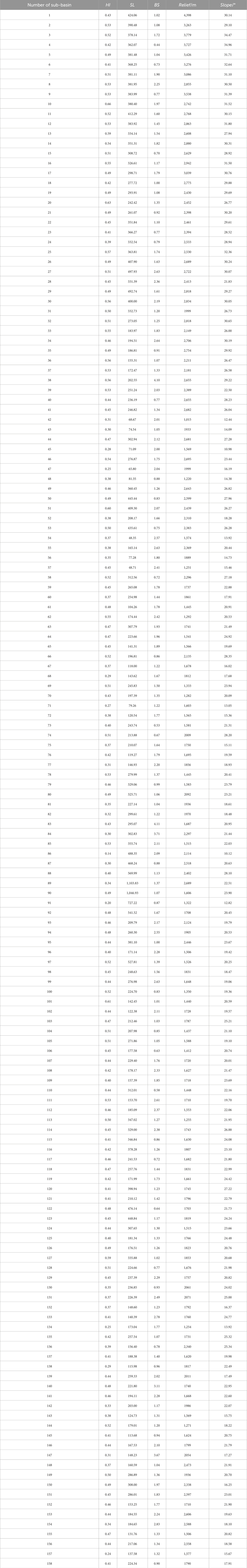
Table 1. Table of parameter values for sub-basins.
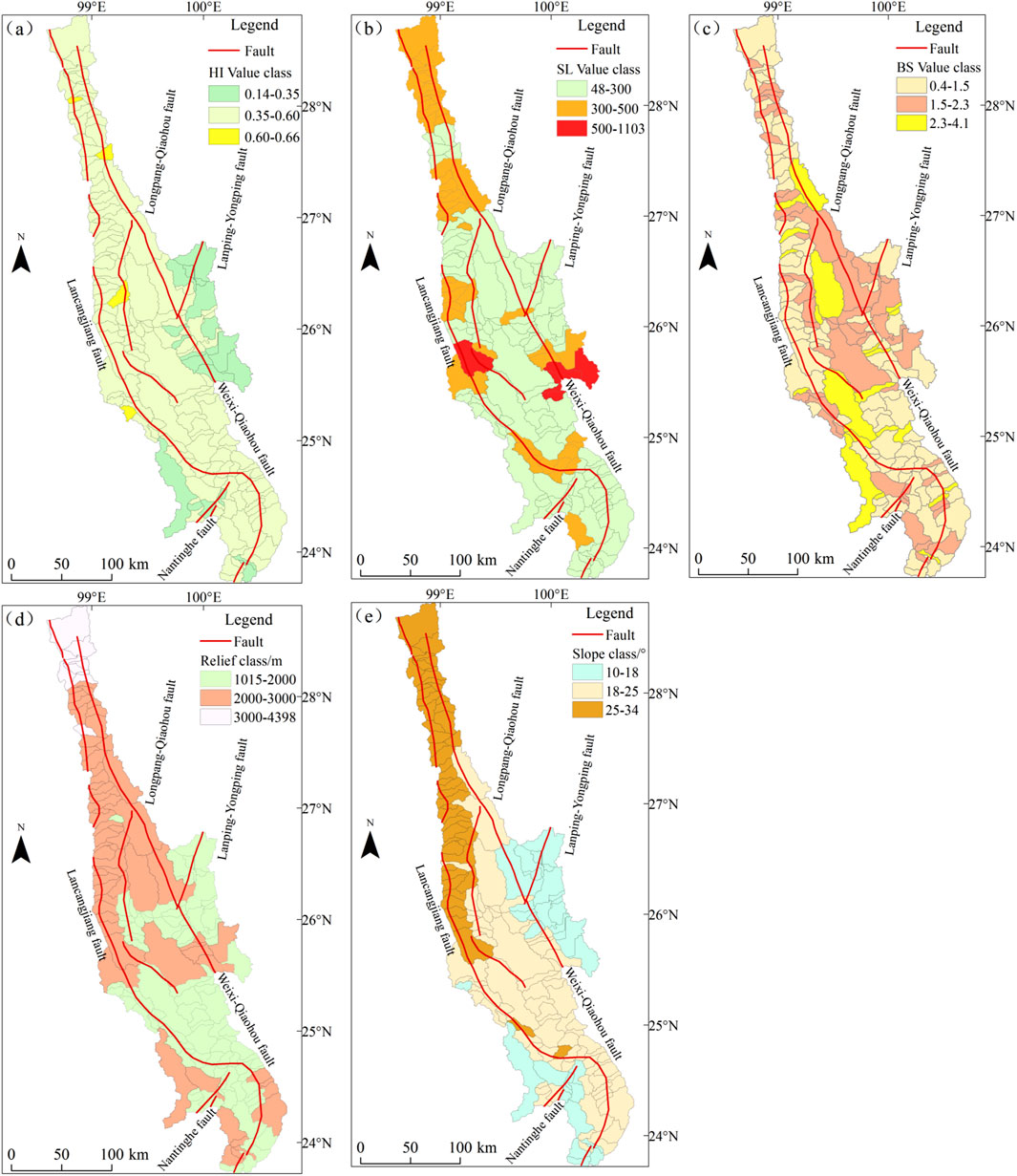
Figure 4. Level diagram map of HI value (a), SL (b), BS (c), relief (d) and slope (e) in the study area.
4.2 Stream length-gradient index
As shown in Table 1, the range of the SL index is from 48 to 1,104. It can be classified into three categories according to the size of stream length-gradient index (El-Hamdouni et al., 2008): SL > 500, 300 <SL < 500, and SL < 300. Among them, the sub-basins with an SL value of <300 are the largest in number. The sub-basins with a median value of 300–500 are mainly located in the upstream area where the Lancangjiang fault is clamped to the Weixi-Qiaohou fault (1∼16, 22∼31 sub-basins), the Lancangjiang fault and Lanping-Yongping fault clamping area (44, 49, 50, 51, 53, 68, 79, 85, 95 sub-basins), the middle and lower sections of the Lancangjiang fault(110, 113, 114, 115, 116, 120, 122, 123, 124, 127 sub-basins), and the southern section of the Weixi-Qiaohou fault (80, 84, 86, 87 sub-basins).The high values greater than 500 are mainly located in the clamping area between the Lancangjiang fault and the Lanping-Yongping fault (88 sub-basins), and in the southern section of the Weixi-Qiaohou fault (89∼92, and 97 sub-basins). As shown in Figure 4B, from the upper reaches to the middle reaches, the values of the SL generally show the characteristics of being higher in the north than in the south and higher in the west than in the east.
4.3 Basin shape index
As shown in Table 1, the values of the BS range from 0.43 to 4.11. According to the BS values, it can be divided into three categories (El-Hamdouni et al., 2008): BS > 2.3, 1.5<BS < 2.3, and BS < 1.5. Among them, the sub-basins with a BS value greater than 2.3 are mainly concentrated in sub-basins 94, 114, 131, 133, 140, 147, and 154 in the middle and upper sections of the Lancangjiang fault zone, sub-basins 99 and 111 in the middle and upper sections of the Lanping-Yongping fault zone, Sub-basin 28 in the middle section of the Weixi-Qiaohou fault, and Sub-basins 83 and 84 in the southern section of the Weixi-Qiaohou fault. The sub-basins with a BS value ranging from 1.5 to 2.3 are mainly concentrated in the intersecting areas of the middle section of the Lancangjiang fault zone, the Lanping-Yongping fault, the southern section of the Weixi-Qiaohou fault, and the Longpan-Qiaohou fault (such as 42, 44, 45, 46, 47, 51, 52, 93, 103, 107, 109, etc. sub-basins), and there are also a small number of them distributed in the southern section of the Lancangjiang fault zone (such as 150, 151, 152, 153, etc. sub-basins). The number of sub-basins with a BS value less than 1.5 is the largest. As shown in Figure 4C, the BS values generally exhibit the characteristic of being higher in the middle and lower in the north and south.
4.4 Topographic relief
There is a large variation in the relief within the basin. As shown in Table 1, the relief of the sub-basins ranges from 1,015 to 4,398 m. Among them, the sub-basins with a relief greater than 3,000 m are mainly located in the area between the Lancangjiang fault zone and the Weixi-Qiaohou fault zone (1–9 and 17sub-basins). The sub-basins with a relief between 2000 m and 3,000 m are mainly distributed along the middle and upper sections of the Lancangjiang fault zone, the northern section of the Lanping-Yongping fault zone, the middle and northern sections of the Weixi-Qiaohou fault zone, and near the Nantinghe fault zone in the middle reaches. The basins with a relief between 1,015 m and 2000 m are mainly concentrated in the southern section of the Lancangjiang fault zone, the southern section of the Weixi-Qiaohou fault, the middle section of the Lanping-Yongping fault, and near the Nantinghe fault and the Longpan-Qiaohou fault. As shown in Figure 4D, the relief is higher in the western part than in the eastern part, and higher in the northern section than in the southern section.
4.5 Slope
The slope is an important factor that controls the surface flow-producing processes, confluence processes, and their flow-mechanical characteristics within the basin. As shown in Table 1, the slope of the sub-basins in the study area range from 10° to 34°. Among them, the sub-basins with slopes ranging from 25° to 34° are mainly concentrated in the area between the northern section of the Lancangjiang fault zone and the northern section of the Weixi-Qiaohou fault zone (such as 1 to 26 sub-basins). After entering the middle reaches, the areas with high slopes are mainly distributed along the Lancangjiang fault zone (such as 49, 50, 88, etc. sub-basins). The sub-basins with slopes ranging from 20° to 25° are concentrated at the “S”-shaped bend of the Lancangjiang fault (103–130 sub-basins), the middle and northern sections (27, 38 sub-basins) and the southern section (83, 87, 89 sub-basins) of the Weixi-Qiaohou fault zone, as well as the northern section of the Lanping-Yongping fault zone (such as 59, 64, 69, 85, etc. sub-basins). The number of sub-basins with slopes ranging from 10° to 20° is the largest. As shown in Figure 4E, the slope also presents a spatial pattern of being higher in the north and lower in the south.
4.6 Distribution characteristics of water system
The river network of the Lancang River is well-developed. The water systems in the upper reaches and the upper-middle reaches mostly originate from mountains. The watershed is a mountain range extending in the NW-SE direction. The main trunk river cuts through the mountains along the direction and flows in the NW-SE direction, while the tributaries cut across the accretionary wedge mountains trending in the NW-SE direction and flow in the SW-NE direction. In the water system of the middle reaches, the main trunk river extends in the SW-NE direction along the mountains, and some local tributaries cut across the mountains and flow nearly in the E-W direction.
In addition, as shown in Figures 1B, 3, in the upstream sub-basins, the lengths of tributaries are the shortest and the areas of sub-basins are the smallest. In the middle and upstream sub-basins, the tributaries in the western part are relatively short in length and the sub-basins are relatively small in area, while the tributaries in the eastern part are relatively long in length and the sub-basins are relatively large in area. The sub-basins in the middle reaches are relatively large in area and the river systems are also long.
5 Analysis
5.1 Analysis of geomorphologic feature
The average value of HI is 0.44, indicating that the geomorphic evolution of the middle and upper reaches of the Yunnan section of the Lancang River Basin is generally in its middle age. Among them, the HI values in the vicinity of Cangshan Mountain and Eryuan County (sub-basins 42, 43, 45, 47, 56, 68, 71, 77, 82, 84, 86, 87, 89, 91) range between 0.14 and 0.35 (Figures 3, 4A), suggesting that the geomorphic evolution has entered the old age. The HI values of sub-basins 10, 20, 51, and 101 are greater than 0.6, indicating that the geomorphic evolution in these areas is still in the young age. The number of sub-basins with a BS value greater than 2.3 is the smallest, followed by those with a BS value between 1.5 and 2.3, and the number of sub-basins with a BS value less than 1.5 is the largest. That is to say, the shapes of the sub-basins of the Yunnan section of the Lancang River Basin are mainly circular and square. In the middle and upper reaches of Yunnan section of Lancang River Basin, there are numerous first-and second-order water systems perpendicular to the mountains in the upper reaches. In the middle reaches, the first- and second-order water systems are parallel to the mountains or form a low angle with them. This indicates that the orogenic belt in the upper reaches of the Yunnan section of the Lancang River Basin formed earlier, and the water system is in the late drainage stage. While the orogenic belt in the middle reaches formed later, and the water system is still in the early drainage stage (Guo and Li, 2024).
5.2 Analysis of geomorphologic influencing factors
5.2.1 Climate factors
Climate is an important factor influencing geomorphic development. It mainly controls the runoff of rivers through precipitation, affects the erosion and transportation of rivers, and further influences the development and evolution of the geomorphology in the river basin (Qin et al., 2023). Based on the annual precipitation data obtained from the China Meteorological Data Network (http://data.cma.cn/site/index.html), this paper uses ArcGIS10.2 to overlay and process the precipitation data, and obtains the spatial distribution of the average annual precipitation of the Lancang River from 2000 to 2021 (Figure 5A).
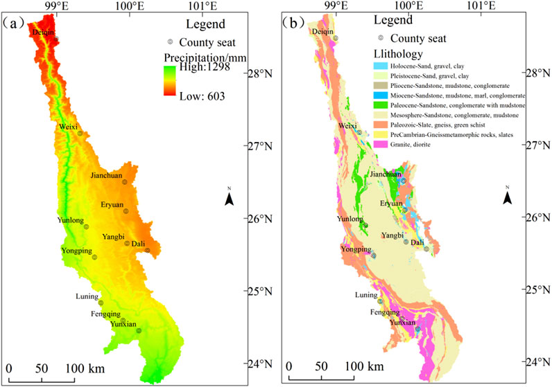
Figure 5. Map of rainfall (a) and rock formation distribution (b) in the study area.
As shown in Figure 5A, the precipitation in the study area is characterized by low precipitation in the upper reaches and high precipitation in the middle reaches. The annual average precipitation is 603∼1,298 mm, and the differences are manifested in both the north-south and east-west sections. If the influences of geological structures and lithology are excluded, the erosive effect of rainfall on the earth’s surface strengthens from the upper reaches along the Lancang River Valley towards the lower reaches and from the east to the west. Correspondingly, the values of HI, BS, and SL should become smaller, while the slope and topographic relief should become larger. However, as shown in Figures 6A,B,D, in the upstream area (sub-basins 1–20), the precipitation is low, with high relief and slope and a low BS value. In contrast, in the mid-upstream area (such as sub-basins 51, 55, 62, etc.), the precipitation is relatively high, with low relief and slope and a high BS value. From the perspective of the same latitude, as shown in Figures 6C,F, in the area of Jianchuan-Eryuan where the precipitation is low, the values of HI and SL are low. While in the Lancang River Valley area at the same latitude, the values of HI and SL are high, which are also inconsistent with the theory.
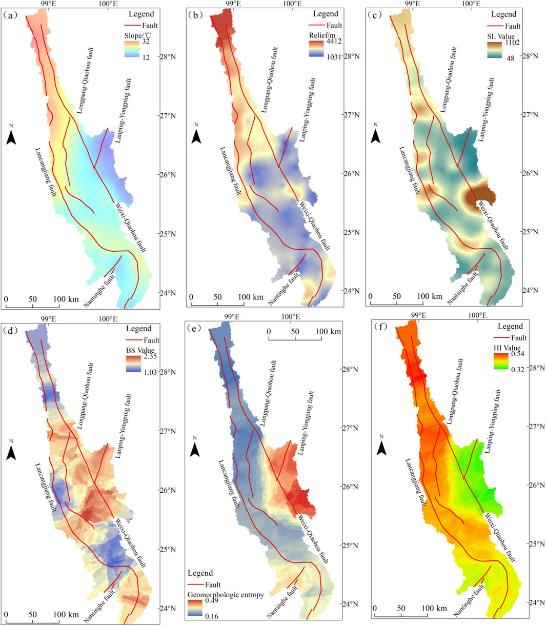
Figure 6. Distribution map of slope (a), relief (b), SL (c), BS (d), geomorphologic entropy (e) and HI value (f) in the study area.
In conclusion, this paper believes that precipitation may only weaken the response of various geomorphic parameters to tectonic movements, but it does not play a decisive role in the geomorphic indices within the river basin. Instead, the distribution of precipitation may be controlled by the topography and tectonic activities of the river basin (Guo and Li, 2024). This is consistent with the research results of previous studies in related areas (Sun et al., 2024).
5.2.2 Lithological factors
Granite and monzonitic granite are mainly distributed in the area of Fengqing County and Yun County in the southwest. Gneiss, slate, phyllite and greenschist are mainly developed along both banks of the Lancang River and in the area from Eryuan County to Dali City. Sand, gravel and clay are concentrated in Dali City, Eryuan County and Jianchuan County. In other regions, sandstone, mudstone and conglomerate are more common. According to the rock strength classification (Topal and Mustafa, 2023), slate, phyllite and greenschist in the basin have the strongest anti-erosion ability, and the geomorphology in the corresponding distribution areas is mostly composed of high mountains. Granite and monzonitic granite have a moderate anti-erosion ability, and the geomorphology in the corresponding distribution areas is mostly composed of medium-high mountains.Sandstone, mudstone and conglomerate have a weak anti-erosion ability, and the geomorphology in the corresponding distribution areas is mountain basins. Quaternary sand, gravel and clay have the weakest anti-erosion ability, and the corresponding distribution areas are mostly alluvial fans.
As shown in Figure 5B, without considering other factors such as tectonics and precipitation, the anti-erosion ability is characterized by weak in the middle, strongest in the southwest, and second in other regions. That is to say, the relief and slope of the river basin should be large in the middle, low in the southwest, and second in other regions. The values of HI, BS and SL should be low in the middle, high in the southwest, and second in other regions. However, in actual situations, the high values of the topographic slope in the river basin are mainly distributed along the Lancang River Valley (sub-basins 1–20). The relief also shows the characteristics of being high in the upstream (sub-basins 1-9) and low in the middle reaches (sub-basins 121–124). The high values of SL and HI are mainly distributed along the Lancang River (Figures 6C,F), while the values of HI and SL are low in the eastern and southwestern parts. The BS values are high in the central, eastern, and southern parts but low in the upstream, which does not match the distribution of the anti-erosion ability of the lithology.
In conclusion, we believe that lithology is not the main controlling factor affecting the geomorphic indices.
5.2.3 Tectonic factors
Through the previous discussions, neither precipitation nor lithology is the main controlling factor for the geomorphic evolution of the middle and upper reaches of the Yunnan section of the Lancang River Basin. Therefore, we believe that the geomorphic evolution of the study area is mainly controlled by the differential uplift movement of regional faults, that is, the geomorphic parameter values of each sub-basin are closely related to the tectonic activities in this area and the surface processes such as uplift and subsidence caused by these activities.
Since the Cenozoic era, the Qinghai-Tibet Plateau has experienced multiple phases of tectonic uplift and planation processes. Entering the Quaternary period, the neotectonic movement has mainly been vertical, characterized by the integrity of uplift, regional differences, and stage-by-stage features (Yang et al., 1982). Among the active tectonic activities on the Qinghai-Tibet Plateau, a series of active tectonic zones extending in a nearly S-N direction are the most intense and prominent, which are clearly reflected in the geomorphology (Han, 1984). The HI, relief, slope, and SL in the study area are mainly distributed on both sides of the Lancangjiang fault, the Lanping-Yongping fault, and the Weixi-Qiaohou fault in the upper reaches, which may be caused by the active tectonics moving from north to south. Moreover, the HI, relief, and slope in the upper reaches of the Lancang River are generally higher than those in the middle reaches. This difference is caused by the different uplift amplitudes in the upper and middle reaches, and it also well reflects the existence of differences in the neotectonic movement of the Quaternary period within the study area. Taking the area where the Weixi-Qiaohou fault is located as an example, as a Holocene fault, field geological surveys have found that the fault trace in the northern section of this fault is more obvious and the fault slip rate is relatively high (Chang et al., 2016; Li et al., 2023). Correspondingly, the HI, relief, slope, and overall SL in the northern section are relatively high.
In addition, as shown in Figure 7A, three levels of peak surfaces have developed in the study area. The elevation of the third-level peak surface ranges from 3,700 to 4,000 m, the elevation of the second-level peak surface ranges from 3,200 to 3,400 m, and the elevation of the first-level peak surface ranges from 2,900 to 3,100 m, which indicates that the tectonic activities in this area are active and multiple tectonic activities have occurred. Around each fault zone, as shown in Figures 7A,B,D, the elevation, relief, slope, and SL value have all undergone changes in elevation, which also shows that the differential activities of the faults control the changes in geomorphic parameters. Especially in the area sandwiched between the Lancangjiang fault and the Lanping-Yongping fault zone, as shown in Figures 7A–D, the values of relief, slope, SL, and HI reach the highest in the profile, which indicates that the sandwiched area is controlled by the two faults, and the topographic relief and slope are relatively high. As for the BS value, it shows a steadily rising trend in the area sandwiched between the Lancangjiang fault and the Lanping-Yongping fault zone (Figure 7E), which is speculated to be related to the relatively low geomorphic information entropy value (Figure 6E). This sandwiched area is located in the west, close to the Qinghai-Tibet Plateau, and is more susceptible to the influence of the uplift of the Qinghai-Tibet Plateau. This leads to a strong confrontation between internal and external geological activities in this area, strengthens the river erosion effect, and promotes the development of the river basin shape towards a circular form (Su et al., 2016). Therefore, the closer to the western side, the lower the BS value.
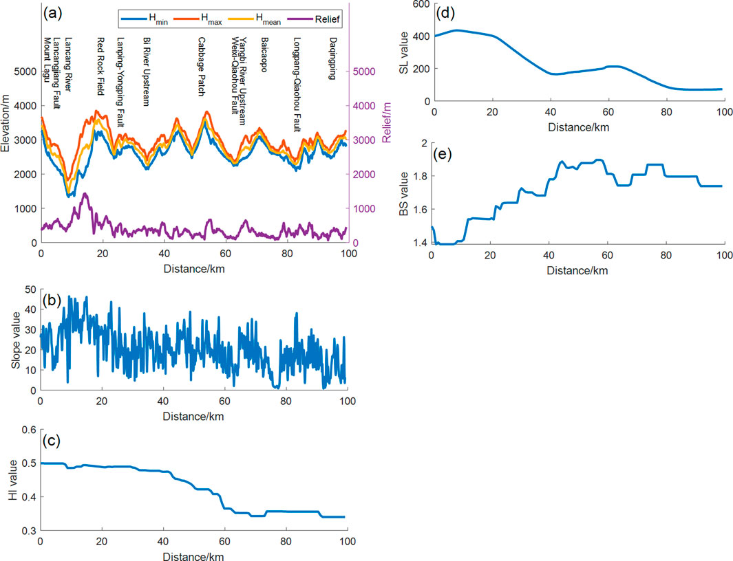
Figure 7. A–A′ section of elevation (a), slope (b), HI value (c), SL (d), BS (e) in the study area.
Based on the above, the overall variation trend of the geomorphic parameter values in the study area is consistent with the geometric space of the faults and the intensity of the tectonic activities, indicating that the geomorphic parameters in the region are significantly affected by tectonic forces. This is consistent with the previous studies (Sun et al., 2024) which pointed out that tectonic activities are the main influencing factors for the geomorphic changes in the southern section of the Lancangjiang fault in Yunnan Province.
5.3 Analysis of geomorphologic and tectonic indicators
5.3.1 Relief and slope
As shown in Figure 5B, in the northern part of the study area, sandstone and medium-to-high grade metamorphic rocks are mainly exposed. In the central part, sandstone is the main outcrop. In the southern part, medium-to-high grade metamorphic rocks, granite and sandstone are developed. Theoretically, due to the different anti-erosion abilities of the three lithologies, and on the premise that there is more rainfall in the middle reaches and less rainfall in the upstream of the study area, and the anti-erosion ability of the middle reaches is lower than that of the upstream, the denudation and erosion ability of the rivers in the northern part should be lower than that in the middle reaches. Consequently, the relief and slope in the upstream should be lower than those in the middle reaches. In fact, as shown in Figures 6A,B, the overall relief and slope in the upstream are greater than those in the mid-upstream and middle reaches. Moreover, the high values of the relief and slope in the middle reaches are mostly near the Lancangjiang fault. This is related to the fact that tectonic activities lead to the uplift of mountains, which increases the slope and relief of the geomorphology, causing the geomorphic evolution to progress towards the prime and juvenile stages (Yao et al., 2023). That is, the high relief and slope in the upstream indicate strong tectonic activity intensity.
5.3.2 Stream length-gradient index
SL is very sensitive to changes caused by lithological erosion or tectonic activities. Relevant studies have linked high SL values to tectonic uplift and the erosion resistance of lithology, while low values may be related to tectonically stable areas or sedimentary areas (Buczek and Górnik, 2020). The above studies indicate that geomorphic indices are not greatly affected by lithology. Then, the overall decrease of the SL value from the upper reaches to the middle reaches (Figure 6C) more comprehensively reflects the trend of the decrease in the intensity of tectonic activities from the upper reaches to the middle reaches. Moreover, in the area sandwiched between the Lancangjiang fault and the Weixi-Qiaohou fault in the upper reaches, the area sandwiched between the Lancangjiang fault and the Lanping-Yongping fault in the middle reaches, and the junction area between the Lancangjiang fault and the Nantinghe fault in the lower part of the middle reaches, the SL values are relatively high, indicating that the tectonic activities in the sandwiched areas are jointly controlled by multiple faults and are relatively strong.
5.3.3 Basin shape index
As shown in Figure 4C, the long and narrow and square sub-basins (with a BS value greater than 1.5) in the area are mainly concentrated in the area sandwiched between the Weixi-Qiaohou fault, the Lanping-Yongping fault and the Lancangjiang fault, as well as the intersection area of the Nantinghe fault and the Lancangjiang fault. This indicates that the faults in the area have a certain controlling effect on the development of the shape of the river basin. As for the area sandwiched between the Weixi-Qiaohou fault and the Lancangjiang fault in the upper reaches, it has a relatively high slope and relief, the tectonic activity is relatively strong (Figures 6A,B). However, the BS value is relatively low (Figure 6D). It is speculated that this is related to the low geomorphic information entropy, and the strong confrontation between internal and external forces accelerates the river erosion and lateral bending effects (Su et al., 2016). In the middle reaches, the slope and relief are low, the tectonic activities are weak, the geomorphic information entropy is high, the confrontation between internal and external forces is weak. The river erosion and lateral bending effects are weakened, the transformation of the sub-basin morphology is weak, and the long and narrow shape is maintained. At the “S”-shaped turn of the Lancang River, the slope, relief and SL indicate low tectonic activities, but the entropy value is high, indicating that the confrontation between internal and external geological forces is weak, and the river erosion and lateral bending effects are not strong. Therefore, the BS value is relatively high, and the shape is mainly of the transitional type.
5.3.4 Hypsometric integral
As shown in Figure 6F, the areas with high HI values are consistent with the strike of the fault structures, which indicates that the HI values are more likely to reflect the strength of tectonic activities. Hong et al. (2019), based on the relative intensities of uplift and erosion, proposed a detailed classification scheme for HI: (1) HI > 0.43 and HI < 0.43 respectively indicate the uplift and erosion stages; (2) HI > 0.60 represents the strong uplift period (juvenile stage). The prime stage is further subdivided into the slow uplift period (0.5<HI < 0.60), the uplift attenuation period (0.43<HI < 0.51) and the uplift stagnation period (0.35<HI < 0.43), and HI < 0.35 is the erosion and down-cutting period (senile stage).
As shown in Figure 8A, the areas in the study region where the HI value is less than 0.43 are mainly distributed in the areas of Jianchuan-Eryuan-Yangbi-Dali City and the southern part of the middle reaches of the Lancang River. This indicates that these two areas are in the erosion stage, and the corresponding relief, slope, and SL are low. The regions with HI > 0.51 are located in the south of Deqin County and the south of Weixi County respectively, indicating that the regions are in the uplift stage, with high topographic relief, slope and SL. The areas with 0.43<HI < 0.51 are mainly distributed in the area of Yunlong-Yongping- Luning, indicating that the tectonic uplift in this area continues, but it is in the attenuation stage, and the corresponding topographic relief, slope gradient and river gradient index are at a relatively high level.
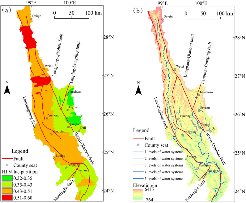
Figure 8. Map of HI zoning (a) and Water system distribution (b) in the study area.
6 Discussion
6.1 Demonstration of the tectonic significance about geomorphology
Previous researchers pointed out that using the sliding rate of the active rupture can quantitatively describe the present-day tectonic deformation (Lu et al., 2023), so we combined the sliding rate of the previous study and the results of the field survey to verify the reasonableness of the tectonic significance of the geomorphic parameters.
The HI values in the southern section of the Lanping-Yongping fault zone range from 0.43 to 0.51, and the HI values in the northern section range from 0.51 to 0.60. The slope and relief values also show a similar distribution, indicating that the tectonic strength of the northern section of this fault zone is higher than that of the southern section. However, due to the lack of research on the slip rate of this fault, there is a lack of corresponding evidence. In the study area, the HI values of the southern section of the Longpan-Qiaohou fault exposed range from 0.14 to 0.43, and the SL index is also low, indicating that the activity of the southern section of this fault is weak, which is consistent with the result that the vertical slip rate of the fault is low (0.05–0.13 mm/a) (Tan, 2014). For the Weixi-Qiaohou fault, the HI values of the southern section range from 0.35 to 0.43, and the HI values of the northern section range from 0.43 to 0.66. The slope and relief also show the same variation. Moreover, the geomorphic information entropy of the northern section of the fault is low, indicating that the tectonic activities and the confrontation between internal and external forces in the northern section are also strong. The field geologic survey also found that the vertical sliding rate of the rift increases from south to north, in the order of 0.18∼0.32 mm/a (Chang et al., 2016), 0.30∼0.35 mm/a (Chang et al., 2022), and 0.3∼0.4 mm/a (Li et al., 2023). The Lancangjiang fault, with HI values between 0.14∼0.35 at the large “S”-shaped bend, and HI values between 0.43∼0.66 to the north of the large “S”-shaped bend, shows the characteristics of high in the south and low at thelarge “S”-shaped bend. And the slope, relief, and SL values change accordingly, i.e., there is a difference in tectonic deformation of the Lancangjiang fault with the large “S”-shaped bend as the dividing line. Yan (2017) had the same understanding when analyzing the deformation of the Lancangjiang fault: the slip deformation near the large “S”-shaped bend is 0.5 mm/a, and the regional deformation north of large “S”-shaped bend is 1.9 mm/a. As for the Nantinghe fault, the northeastern section of the fault zone is exposed in the study area. Its HI value is low, ranging from 0.35 to 0.43, indicating that the tectonic deformation in the fault zone is weak. This is consistent with the conclusion drawn from previous field investigations that the activity of the northeastern section is significantly weaker (Wang et al., 2006).
In summary, we believe that the geomorphological parameters of the middle and upper reaches of the Yunnan section of the Lancang River Basin are reasonable indicators of tectonic activity.
6.2 Discussion on the relationship between tectonic activity and the pattern of river systems
As shown in Figure 8B, the strike of the faults within the river basin is in good agreement with the direction of the river channels, indicating that the strike of the faults has an obvious controlling effect on the flow direction of the river channels. There are two very typical cases. One is that the flow direction of the main stream of the Lancang River is consistent with the strike of the Lancangjiang fault. Especially at the bend in the middle reaches, the Lancangjiang fault is distributed in an “S” shape, and the flow direction of the Lancang River channel also shows an “S” shape. The other is that the flow direction of the upper reaches of the Yangbi River is consistent with the strikes of the Weixi-Qiaohou fault and the Longpan-Qiaohou fault. Taking the Yangbi River and the Luozha River as examples below, we will explore the relationship between tectonic activities and the pattern of the river system.
In the Yangbi River Basin, the Weixi-Qiaohou fault trending northwest and the Longpan-Qiaohou fault trending northeast are exposed in the upper reaches. There are two tributaries: the eastern and western tributaries. The western tributary originates from Jianchuan County, and the eastern tributary originates from Eryuan County.In the upper reaches area, the courses of the eastern and western tributaries of the Yangbi River are consistent with the strike of the Longpan-Qiaohou fault, that is, the river flows from northeast to southwest. The western tributary makes a turn at the intersection of the faults, evolving from the previous southwest-oriented channel into a southeast-oriented channel. The eastern tributary also makes the same channel turn near Eryuan County and is consistent with the strike of the Weixi-Qiaohou fault. This indicates that the strikes of the Weixi-Qiaohou fault and the Longpan-Qiaohou fault control the flow directions of the eastern and western tributaries of the Yangbi River. In the Luozha River Basin near Yun County, Fengqing County and Changning County, the upper reaches of the river maintain the same flow direction as the Lancangjiang fault, that is, the channel is oriented southeast. Near the Nantinghe fault, the river channel deflects and the flow direction changes to northeast. This channel deflection is related to the dislocation of the river system caused by the strike-slip of the Nantinghe fault. In the lower reaches, the flow direction of the Luozha River changes and it turns to flow east-west into the main stream of the Lancang River.
The above research shows that HI indicates that the upstream and the western part of the mid-upstream are generally in a stage of slow tectonic uplift (with some local areas in a stage of intense uplift), and the tectonic situation is unstable. The river system does not have sufficient time and space for development, and it is in an incompletely developed state or a newly formed state (Li et al., 2021). Therefore, as shown in Figures 1B, 3, the tributaries in the corresponding area are short, and the area of the sub-basins is small. In the area of Jianchuan-Eryuan-Yangbi-Dali City, the HI value is less than 0.43, indicating that it is in the erosion stage and the tectonic situation is relatively stable. This provides more development time and space for the development of each tributary. The river length of sub-basins is longer than that in the western, and the area of sub-basins is also larger than that of the western part at the same latitude. The middle reaches are in the erosion period, which provides good development space and time for the development of the river, and the area of sub-basins is also relatively large. As shown in Figure 8B, the river system is relatively well-developed.
In conclusion, we believe that the asymmetric pattern of the river system between the east and the west and the uneven pattern between the upper and middle reaches of Yunnan section of the Lancang River Basin, as well as the formation of the flow direction of the river channels, are related to the tectonic uplift and deformation of the region.
7 Conclusion
Through the analysis of the relief, slope, HI, SL, BS, and geomorphic information entropy in the Yunnan section of the Lancang River Basin, the geomorphic characteristics of the river basins in the area were systematically summarized. Based on the analysis of faults, rainfall, and lithology, the main controlling factors of the geomorphology were analyzed. Combined with the slip rate, the tectonic significance of the geomorphology of the river basins was verified. Finally, the influence of tectonic uplift and deformation on the development of the river system in the Yunnan section of the Lancang River was discussed. The main conclusions are as follows:
(1) The distributions of relief, slope, HI, SL, and BS are mainly controlled by tectonic activities, and the influences of rock strata and rainfall on the geomorphology are limited. The relief, slope, HI, and SL can well reflect the characteristics of regional tectonic geomorphology and activities. Among them, the slope and relief degree indicate that the tectonic activities decrease from the upstream to the middle reaches. HI indicates that the Yunnan section of the Lancang River Basin is generally in its prime stage, and SL indicates that the tectonic activities in the area sandwiched by faults are strong.
(2) In the area, the tectonic uplift in Jianchuan-Eryuan-Yangbi-Dali City and the southern part of the middle reaches of the Lancang River has stagnated and evolved towards the erosion-deposition stage. The southern part of Deqin County and the southern part of Weixi County are in the uplift stage, while the tectonic uplift in the area of Yunlong-Yongping-Luning has entered the attenuation stage.
(3) In the area, the activity intensity of the Lanping-Yongping fault and the Weixi-Qiaohou fault decreases from north to south. The activity intensity at the big bend of the Lancangjiang fault is low, and the tectonic activities in the northern section are strong. The tectonic deformation in the southern section of the Longpan-Qiaohou fault and the northeastern section of the Nantinghe fault is weak.
(4) Affected by tectonic activities and faults, the secondary river systems in the upstream of the study area are in the vertical drainage stage, and the secondary river systems in the downstream are in the longitudinal drainage stage. The overall river system is still in the longitudinal drainage stage. The pattern of the river system in the area is a macroscopic response to the tectonic uplift and lateral deformation of the middle and upper reaches of Yunnan section of the Lancang River Basin.
Data availability statement
The original contributions presented in the study are included in the article/Supplementary Material, further inquiries can be directed to the corresponding author.
Author contributions
SL: Writing – original draft, Formal Analysis, Methodology. YQ: Formal Analysis, Supervision, Writing – review and editing. NLi: Data curation, Writing – review and editing, Methodology. NLu: Writing – review and editing, Methodology, Supervision. SY: Methodology, Writing – review and editing. YX: Writing – review and editing, Methodology. JL: Formal Analysis, Writing – review and editing. RL: Writing – review and editing, Formal Analysis. HH: Software, Writing – review and editing.
Funding
The author(s) declare that financial support was received for the research and/or publication of this article. This study was supported by funds from the 2024 Project of the Key Research Base of Region and Country of Sichuan Province, Centre for Southeast Asian Economy and Culture Studies (No. DNY2401); the 2023 Project of the Key Research Base of Region and Country of Sichuan Province, Centre for Southeast Asian Economy and Culture Studies (No. DNY2304); and the Sichuan Science and Technology Program (No. 2022YFS0488).
Conflict of interest
The authors declare that the research was conducted in the absence of any commercial or financial relationships that could be construed as a potential conflict of interest.
Generative AI statement
The author(s) declare that no Generative AI was used in the creation of this manuscript.
Publisher’s note
All claims expressed in this article are solely those of the authors and do not necessarily represent those of their affiliated organizations, or those of the publisher, the editors and the reviewers. Any product that may be evaluated in this article, or claim that may be made by its manufacturer, is not guaranteed or endorsed by the publisher.
Supplementary material
The Supplementary Material for this article can be found online at: https://www.frontiersin.org/articles/10.3389/feart.2025.1594817/full#supplementary-material
References
Ai, N., and Yue, T. (1988). Second discussion of comentropy in erosional drainage-system. J. Soil Water Conservation 2 (4), 1–8.
An, X., Chang, Z., Chen, Y., Mao, X., and Zhuang, R. (2018). Quaternary active fractures in Yunnan and “distribution map of quaternary active fractures in Yunnan”. Beijing: Seismological Press.
Buczek, K., and Górnik, M. (2020). Evaluation of tectonic activity using morphometric indices: case study of the Tatra Mts. (Western Carpathians, Poland). Environ. Earth Sci. 79, 176. doi:10.1007/s12665-020-08912-9
Cannon, P. J. (1976). Generation of explicit parameters for a quantitative geomorphic study of Mill Creek drainage basin. Okla. Geol. Notes 36 (1), 3–16.
Chang, Y. (2021). Hypsometry of drainage basins and its tectonic implications across Deqin-Weixi area. Seismol. Geomagnetic Observation Res. 257 (S1), 142–144.
Chang, Z. (2014). Research on quantitative geomorphologic in dices of bailong jiang drainage basin in the eastern Tibet Plateau based on digital elevation models. Nanjing: Nanjing Normal University.
Chang, Z., Chang, H., Li, J., Dai, B., Zhou, Q., Zhu, J., et al. (2016). The characteristic of active normal faulting of the southern segment of Weixi-Qiaohou Fault. J. Seismol. Res. 39 (4), 579–586.
Chang, Z., Li, J., Chang, H., Luo, L., Liu, C., and He, S. (2022). Late-quaternary activity of tongdian-madeng basin segment of Weixi-Qiaohou fault. Acta Sci. Nat. Univ. Pekin. 58 (5), 875–888. doi:10.13209/j.0479-8023.2022.057
Chang, Z., Wang, J., Bai, S., and Zhang, Z. (2015). Comparison of hypsometric integral methods. J. Arid Land Resour. Environ. 29 (3), 171–175. doi:10.13448/j.cnki.jalre.2015.100
El-Hamdouni, R., Irigaray, C., Fernández, T., Chacón, J., and Keller, E. (2008). Assessment of relative active tectonics, southwest border of the Sierra Nevada (southern Spain). Geomorphology 96, 150–173. doi:10.1016/j.geomorph.2007.08.004
Fan, Y., Pan, B., Hu, Z., Ren, D., Chen, Q., Liu, F., et al. (2018). An analysis of tectonic geomorphologic characteristics of the Beipanjiang Basin in the Yunnan-Guizhou Plateau. Adv. Earth Sci. 33 (7), 751–761. doi:10.11867/j.issn.1001-8166.2018.07.0751
Gan, S., and Yuan, X. (2005). Geographic information processing and physiognomy morphological of analysis of the Lancang River basin. Yunnan Geogr. Environ. Res. 17 (4), 1–5.
Guo, X., and Li, J. (2024). Fluvial geomorphic characteristics of taiwan Island, China and its TectonicImplications. Acta Sci. Nat. Univ. Pekin. doi:10.13209/j.0479-8023.2024.004
Hack, J. T. (1973). Stream-profiles analysis and stream-gradient index. J. Res. U.S. Geol. Surv. 1 (4), 421–429.
Hadji, R., Taib, H., Gentilucci, M., Hamed, Y., Khalil, R., Asghar, B., et al. (2024). Assessment of active tectonics using geomorphic indices and morphometric parameters in the setifian Highlands region. Earth 5 (4), 583–603. doi:10.3390/earth5040030
He, B., Zhao, Z., Mao, Y., and Wang, D. (2013). Landform division in lancang-mekong river area. Trop. Geogr. 33 (3), 264–268.
Hong, Y., Zhao, Y., Wang, Y., Xin, C., and Zhang, T. (2019). Study on the geomorphic uplift characteristics of the Longmenshan fault zone using hypso-metric integral method. Sci. Technol. Eng. 19 (30), 43–51.
Ji, F., Qi, X., Chang, Y., Zhang, C., Zhao, Y., and Wei, C. (2015). Cenozoic polyphase structural deformation characterization in the middle segment of the Lancang tectonic zone, western Yunnan, and its geochronological constraints. Acta Petrol. Sin. 31 (12), 3713–3724.
Lee, C. S., and Tsai, L. L. (2010). A quantitative analysis for geomorphic in-dices of longitudinal river profile: a case study of the choushui river, central taiwan. Environ. Earth Sci. 59 (7), 1549–1558. doi:10.1007/s12665-009-0140-3
Li, J., Zufeng, C., and Lata, A. (2023). Geological and geomorphological features of late quaternary activity in the northern segment of Weixi–Qiaohou Fault. Acta Geosci. Sin. 45 (3), 309–319. doi:10.3975/cagsb.2023.112701
Li, M., Zhang, S., Jiang, D., and Liang, K. (2019). Geomorphic features and tectonic significance of the middle and north section of Longmenshan. Technol. Earthq. Disaster Prev. 14 (3), 640–651.
Li, Y., Zhou, R., Liang, Y., Yan, Z., Ding, H., Shao, C., et al. (2021). Tectonic geomorphology and surface processes in Longmen Mountains. Beijing: Science Press.
Li, Z., Ren, J., Meng, G., Yang, P., and Hu, R. (2014). Deformation model inverted from focal mechanism data in and around Chinese main land. Earthquake 34 (3), 1–12. doi:10.3969/j.issn.1000-3274.2014.03.001
Liu, H., Liu, J., and Tang, H. (1998). Present and future of water resources development in Lancang River Basin in Yunnan province. Adv. Water Sci. 9 (1), 69–76. doi:10.14042/j.cnki.32.1309.1998.01.012
Liu, J., Chang, Y., Tian, P., and Li, S. (2023). Geomorphic characteristics of drainage basins in Deqin-Weixi area and their response to tec-tonic activities. J. Seismol. Res. 46 (3), 315–322. doi:10.20015/j.cnki.issn1000-0666.2023.0033
Liu, J., Zhang, J., Yukui, G, Wang, W., Zeng, L., Gen, L., et al. (2018). Tectonic geomorphology: an interdisciplinary study of the interaction among tectonic climatic and surface processes. Chin. Sci. Bull. 63 (30), 3070–3088. doi:10.1360/n972018-00498
Loreto, A., Gerardo, De V., Muñoz-Martín, A., and Stokes, M. (2014). Using river long profiles and geomorphic indices to evaluate the geomorphological signature of continental scale drainage capture, Duero basin (NW Iberia). Geomorphology 206, 250–261. doi:10.1016/j.geomorph.2013.09.028
Lu, F., Gao, M., Zhou, S., and Wang, S. (2023). Fluvial geomorphology of the eastern altyn tagh and its tectonicactivity implication. Geoscience 37 (5), 1100–1109.
Pan, B., Jijun, L, and Binyuan, L (2000). Discussion on evidences for surface uplift of the Tibetan Plateau. J. Lanzhou Univ. Sci. 36 (3), 100–111.
Peng, yunlong (2014). Research of Tectonic activity and Landscape evolution characteristics in Lushan based on DEM[D]. Nanjing: Nanjing Normal University.
Pike, R. J., and Wilson, S. E. (1971). Elevation-relief ratio, hypsometric integral, and geomorphic area-altitude analysis. Geol. Soc. Am. Bull. 82 (4), 1079–1084. doi:10.1130/0016-7606(1971)82[1079:erhiag]2.0.co;2
Qin, C., Li, J., Zheng, L., and Bai, Y. (2023). Study on tectonic geomorphology of area—elevation integral in Lianfeng and Zhaotong—ludian fault zone. Geol. Rev. 69 (5), 1649–1660.
Strahler, A. H. (1952). Hypsometric (area-altitude) analysis of erosional topography. Bull. Geol. Soc. Am. 63 (11), 1117–1142. doi:10.1130/0016-7606(1952)63[1117:haaoet]2.0.co;2
Su, Q, Yuan, D., and Xie, H. (2016). Geomorphic features of the Heihe river drainage basin in western Qilianshan-Hexi corridor and its tectonic implications. Seismol. Geol. 38 (3), 560–581. doi:10.3969/j.issn.0253-4967.2016.03.005
Sun, L., Dong, Y., Wu, Z., Zhang, S., Li, L., and Liu, Z. (2024). Study on tectonic activity of the southern Lancang River fault based on the stream geomorphic index. Chin. J. Geol. 59 (6), 1543–1561. doi:10.12017/dzkx.2024.107
Taib, H., Hadji, R., Bedri, K., Defaflia, N., Hamed, Y., Gentilucci, M., et al. (2024). Morphometric analysis and risk assessment of flash floods in the Atlas chain of eastern Algeria and the Algerian–Tunisian borders. Euro-Mediterranean J. Environ. Integration 10 (2), 749–763. doi:10.1007/s41207-024-00617-w
Tan, Y. (2014). A study on the slip rates of the Longpan-Qiaohou fault zone in Late Quaternary[D]. (master‘s thesis). Inst. Earthq. Forecast. China Earthq. Adm.
Tang, Y., Yin, F., Wang, L., Wang, D., Liao, S., and Sun, Z. (2013). Structural characterization of and geochronological constraints on sinistral strike-slip shearing along the southern segment of Chongshan shear zone, western Yunnan. Acta Petrol. Sin. 29 (04), 1311–1324.
Topal, S., and Mustafa, S. (2023). Geomorphic signature of active tectonics in Simav Graben: an evaluation of indicator relative tectonic activity of Simav Fault and its seismotectonic implications for Western Anatolia. J. Earth Syst. Sci. 132, 95. doi:10.1007/s12040-023-02110-4
Wang, D., Dong, Y. P., Jiao, Q., Zhang, D., Duan, J., Yu, H., et al. (2022). The mechanism of tectonic deformation of the central Yunnan Terrane in the Late Cenozoic Based on tectonic geomorphology. Earth Sci. 47 (8), 3016–3028. doi:10.3799/dqkx.2021.146
Wang, D., Yin, G., Han, F., Liu, C., and Mao, Z. (2017). Geomorphology of the gyaring co fault zonal drainage system and its structural implications. Seismol. Geol. 39 (2), 304–321. doi:10.3969/j.issn.0253-4967.2017.02.004
Wang, J., Wang, Y., An, X., and Yang, X. (2006). Analysis of latest activity on NE-segment of West branch of nantinghe fault. J. Seismol. Res. 29 (3), 264–268. doi:10.3969/j.issn.1000-0666.2006.03.010
Wang, S., Wu, S., and Dai, E. (2005). River differentiation reflected by statistical relationships of river geomorphologic parameters: a case study of the related tributaries in the Yunnan section of Lancang River River. Adv. Nat. Sci. 15 (7), 824–829. doi:10.3321/j.issn:1002-008X.2005.07.009
Yan, H. (2017). Study on the crustal deformation and characteristics of main faults in central yunnan region constrained by GPS measurements[D]. (master‘s thesis). Inst. Earthq. Res. China Earthq. Adm.
Yang, Y., Li, B., Yin, Z., and Zhang, Q. (1982). The formation and evolution of landform in the xizang plateau. Acta Geogr. Casinica 37 (1), 76–87. doi:10.11821/xb198201009
Yao, W., Xiong, K., Fan, Y., and Lyu, X. (2023). DEM-based analysis of tectonic geomorphologic characteristics and tectonic activity intensity of the Dabanghe River Basin in South China Karst. Open Geosci. 15 (1), 20220481. doi:10.1515/geo-2022-0481
Keywords: hypsometric integral, basin shape index, stream length-gradient index, water system style, Lancang River Basin, lancangjiang fault
Citation: Li S, Qing Y, Li N, Lu N, Yang S, Xu Y, Liu J, Liu R and He H (2025) Geomorphologic feature and its tectonic significance in the middle and upper reaches of Yunnan section of the Lancang River Basin. Front. Earth Sci. 13:1594817. doi: 10.3389/feart.2025.1594817
Received: 17 March 2025; Accepted: 20 May 2025;
Published: 05 June 2025.
Edited by:
Vlad Constantin Manea, National Autonomous University of Mexico, MexicoReviewed by:
Riheb Hadji, University Ferhat Abbas of Setif, AlgeriaVedat Avci, Bingöl University, Türkiye
Copyright © 2025 Li, Qing, Li, Lu, Yang, Xu, Liu, Liu and He. This is an open-access article distributed under the terms of the Creative Commons Attribution License (CC BY). The use, distribution or reproduction in other forums is permitted, provided the original author(s) and the copyright owner(s) are credited and that the original publication in this journal is cited, in accordance with accepted academic practice. No use, distribution or reproduction is permitted which does not comply with these terms.
*Correspondence: Yuanhua Qing, MDUxMDYxQGNkbnUuZWR1LmNu