 Shuxia Li
 Fang Xiang2*
 Hewen Ma
 Bin Xu
- 1College of Geoscience and Surveying Engineering, China University of Mining and Technology, Beijing, China
- 2State Key Laboratory of Oil and Gas Reservoir Geology and Exploitation, Chengdu University of Technology, Chendu, China
- 3Hebei State Key Laboratory of Mine Disaster Prevention, North China Institute of Science and Technology, Beijing, China
- 4CCTEG Xi’an Research Institute (Group) Co., Ltd., Xi’an, China
The Late Mesozoic is a typical period for studying the greenhouse climate and the interaction of the Eearth’s systems. To expound the interaction between the evolution process of the terrestrial surface system and the environment in the Late Jurassic -Cretaceous, a typical profile with relatively complete exposure of the Mesozoic strata in the Emei area of the Sichuan Basin, the Chuanzu Profile, was selected for this study. The sedimentary environment of the study area was qualitatively analysed based on the macroscopic characteristics of the lithostratigraphy of outcrop profiles in the field and the statistical data of detrital composition under a microscope. Factor analysis and the chemical alteration index after correction (CIAcorr) were used to quantitatively analyse the characteristics of major and trace elements. Finally, the palaeoclimatic evolutionary characteristics of the Late Jurassic-Cretaceous in the Emei area are systematically discussed. The results show that the formation of Cretaceous sediments in the Emei area of the Sichuan Basin is mainly controlled by climatic factors, but is little affected by tectonic activities, and the maturity of the rock clastic composition is relatively low; therefore, it should be a near-provenance deposit. The range of CIAcorr values was 55–79, indicating that the degree of chemical weathering of the provenance was weak to moderate. The palaeoclimate in the Late Jurassic gradually became humid from Early to Late; in the Early Cretaceous, it was semiarid to semihumid, with an extremely dry event occurring; and in the Late Cretaceous, it was semiarid and drier than that of the Early Cretaceous.
1 Introduction
One of the most effective methods for exploring the relationship between greenhouse gases, such as carbon dioxide produced by human activities, and the Earth’s surface system is to find typical examples from geological history for comparative research (Wang et al., 2009). The Mesozoic was an important period in the history of Earth and the evolution of life and had a typical warm climate that is closest to the present day (Parrish, 1993; Ogg et al., 2016). The global climate variability, high atmospheric carbon dioxide concentration and large-scale climate fluctuation events of the Mesozoic are similar to those of the present-day changeable Earth system (Wang et al., 2014). Evidence of the Mesozoic climate and environmental change mainly comes from the environmental records of marine sediments, whereas records from terrestrial sediments are scanty (Wilf et al., 2003; Bodin et al., 2015).
The Sichuan Basin, located in southwest China, is a representative Mesozoic continental sedimentary basin (Li et al., 2022). Relatively continuous Triassic, Jurassic, and Cretaceous profiles are exposed in the Emei area of the southwestern Sichuan Basin, providing a natural laboratory set-up withideal materials for studying Mesozoic continental climate change (Wang et al., 2010a). Previous studies have been conducted on the palaeoclimate of the Emei area. For example, Hu et al. (1991) concluded that the Early Cretaceous Jiaguan Formation in the Emei area was an arid fluvial environment, based on the distribution characteristics of trace fossil communities in fluvial depositional environments. Deng et al. (2013) inferred that the Jiaguan Formation in the Emei area is in a arid environment based on lithologic associations and sedimentary structure characteristics. Based on dinosaur footprints in the vertical profile of the Jiaguan Formation in the Emei area, Lu et al. (2013) inferred that dinosaurs lived in an arid environment. By studying lithological markers and continental ichnofabric, Chen (2014) concluded that the Jiaguan Formation in the Emei area was formed in an alternating dry and wet climate. Previous studies on the palaeoclimate of the Emei area in the Sichuan Basin have mainly focused on the Early Cretaceous Jiaguan Formation, with little attention paid to the entire evolutionary process and changes in palaeoclimate from the Late Jurassic to the Late Cretaceous. Elemental geochemistry is an important tool for studying the composition of sedimentary materials; the distribution of the sedimentary materials in geological layers is closely related to climate change (Chakrapani, 2005; Mahanipour, et al., 2019), which can effectively reflect changes in the ancient climate (Chen et al., 2024). Therefore, it is necessary to conduct an elemental geochemical analysis of sediments in the Emei area of the Sichuan Basin.
In this study, a typical profile with relatively complete exposure of Mesozoic strata in the Emei area of the Sichuan Basin, the Chuanzu Profile, was used to study the sedimentary petrological characteristics, geochemical records, and palaeoclimatic changes. The main factors controlling the chemical composition of the sediments were identified through factor analysis and the corrected chemical index of alteration (CIAcorr) was used to analyse the palaeoclimate of this sedimentary basin. This study provides important references and basic data for further research on the evolutionary process of the Jurassic-Cretaceous palaeoclimate in the Sichuan Basin, and current and future possible climate change.
2 Geological setting
The Sichuan Basin is a diamond-shaped tectonic basin located in southwestern China that comprises Mesozoic continental foreland basin sediments dominated by thick terrestrial clastic rocks (Hao et al., 2008). According to the differences in the sedimentary environment, sedimentary facies, biofacies, strata development, and ore bearing-strata, the distribution area of Cretaceous strata in the Sichuan Basin was divided into four districts: Jiange District, Zitong-Bazhong District, Ya’an-Chengdu District, and Yibin District (Geology and Mineral Resources Bureau of Sichuan Province, 1991). Emei area is located in the southwest of Sichuan Basin, belonging to Chengdu-Ya’ District, with a total area of 1,183 km2 enclosed within the latitudes 103°10′to 103°37′E and longitudes 29°16’to 29°43′N (Figure 1).
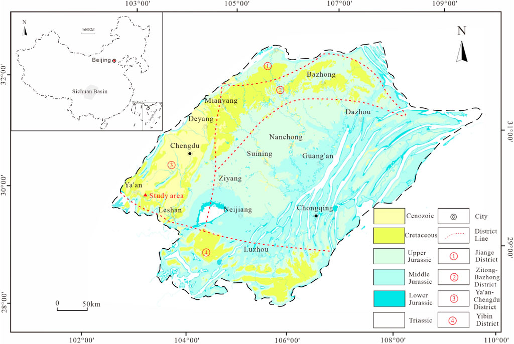
Figure 1. Map showing regional geological feature and profile location (revised from Chen and Lu, 2009; Li, 2016).
The Mesozoic strata in the Emei area, from old to new, are the Penglaizhen Formation of the Late Jurassic, Jiaguan Formation of the Early Cretaceous, and Guankou Formation of the Late Cretaceous. The Penglaizhen Formation is composed mainly of purple mudstone, shale, and siltstone. The Jiaguan Formation is mainly composed of red brick sandstone and mudstone, and contains parallel bedding, large cross-bedding, wedge cross-bedding, wavy bedding, mud cracks, and trace insect structures. The Guankou Formation is mainly composed of purple–red and brick–red mudstone interbedded with thin layers of siltstone with visible horizontal bedding, cross bedding, wavy bedding, and insect trace structures. This basin during the Late Jurassic experienced a lacustrine sedimentary environment (Wang and Xu, 2001), whereas during the Cretaceous it experienced a delta sedimentary environment, further divided into delta front, delta plain, and pre-delta sedimentary environments (Cao et al., 2008) (Figure 2).
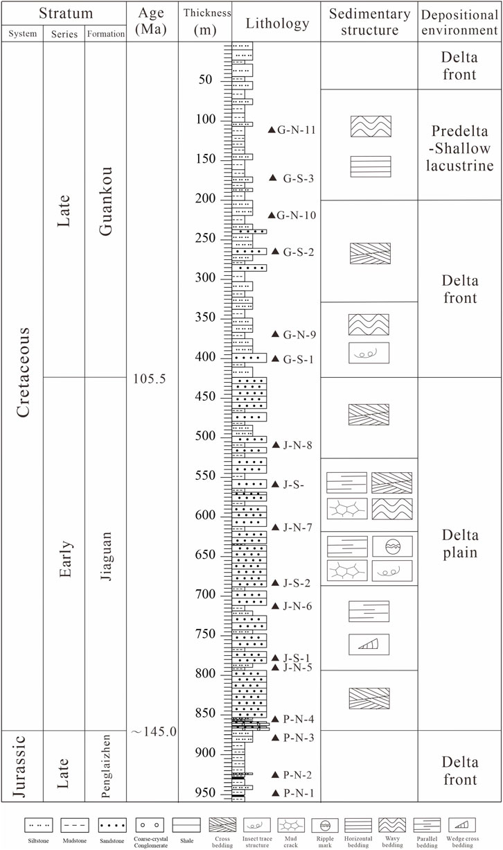
Figure 2. Columnar section showing the stratigraphy, sedimentary structures, and environment of the Mesozoic in the Emei area of Sichuan Basin.
3 Samples and experimental method
3.1 Samples
In the Emei Area, this study selected a relatively complete Mesozoic stratum, Chuanzu Province, with a total length of 958.93 m. Samples were taken with an average of 50–100 m spacing, and with obvious colour or lithological differencesto maintain homogeneity and freshness of the samples, respectively. A total of 17 samples were collected, including 11 mudstones and 6 sandstones (Figure 2).
3.2 Experimental method
3.2.1 Identification of rock and minerals
Rocks and minerals were identified at the State Key Laboratory of Oil and Gas Reservoir Geology and Exploitation, Chengdu University of Technology, China. Micro-section identification and analysis of detrital components in the sandstone samples were carried out in accordance with the SY/T5368.2–1995 and GB/T 17,412.2–1998 standards, respectively. The microscope model used was OLYMPUS-BX51. Scanning electron microscope (SEM) analysis of the mudstone was carried out in accordance with the SY/T 5162–1997 standard, using backscattered electrons and a Qunta 250 PEG instrument. The observation magnification limit of the instrument is 500,000–30000000 times, and the magnification for this test was 2,600–48000 times.
3.2.2 Geochemical analysis
Major and trace element analyses of the mudstone samples were completed at the Ausilicon Analytical Testing (Guangzhou) Co., Ltd. Analysis of the major elements were performed according to GB/T14506.28–2010. The mudstone sample (0.7 g) was placed in a platinum crucible, and 5.2 g of anhydrous lithium tetraborate (Li2B4O7), 0.4 g of lithium fluoride, 0.3 g, ammonium nitrate, and 1 mL of lithium bromide were poured into the crucible; the mixture was stirred evenly, dried on an electric heating plate, and then melted using a melting machine at 1,150 °C. The melt was allowed to cool and crystallize, and finally, glass samples were prepared and tested using an X-ray fluorescence spectrometer (Panalytical DY3595; Panaco, Sweden) with a testing error of less than 5%.
The trace elements were prepared according to the GB/T14506.30–2010. First, a mudstone sample (50 mg) was placed in tetrafluoroethylene (PTFE) test tube. Nitric acid (HNO3) and hydrofluoric acid (HF) were then added and dissolved in a sealed melt vessel. The sample was removed and placed on an automatic temperature-controlled electric heating plate for evaporation. Finally, HNO3 was added and the sample was dissolved in a sealed melting vessel before cooling to room temperature (∼26°C). Finally, the samples was diluted to volume by adding H2O, shaken well, and transferred to a test tube for testing. Trace elements were determined using an ICP-MS instrument (Agilent 7900, US) with a testing error of less than 10%.
4 Results
4.1 Detrital component characteristics
Macroscopically, the Late Jurassic in the study area was represented by a set of purple-red silty mudstones with thin layers of limestone (Figures 3a), being sedimentation of the delta front (Li et al., 2020). The Early Cretaceous Jiaguan Formation is mainly composed of a set of thick brown–red massive fine-grained sandstone with thin layers of mudstone (Figures 3b) and a mud-cracked structure (Figures 3c), being sedimentation of the delta plain. In the Late Cretaceous Guankou Formation, the lithology is mainly purple and brick red mudstone and siltstone (Figures 3b), with a large amount of gypsum development (Figures 3d), forming anhydrite-moldic pores (Figures 3e), gypsum grains, and crystal holes (Figures 3f), being sedimentation of the delta front and predelta - shallow lacustrine.
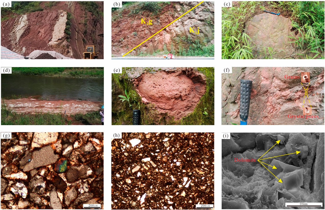
Figure 3. Photographs showing the lithological and detrital characteristics of the Jiaguan and Guankou Formations in the Emei Area (modified from Li, 2018). (a) Purple-red mudstone within thin-bedded limestone, Penglaizhen Formation; (b) The boundary between Jiaguan and Guankou Formations; (c) Mud cracks, Jiaguan Formation; (d) Gypsum, Guankou Formation; (e) Anhydrite-moldic pores, Guankou Formation; (f) Gypsum grains and crystal hole, Guankou Formation; (g) Calcareous quartz Sandstone, Jiaguan Formation; (h) Calcareous claystone siltstone, Guankou Formation; (i) Dolomite, Guankou Formation.
Microscopically, for the quartz sandstone of the Jiaguan Formation, the sorting was medium, and the grains were subrounded to subangular. The content of quartz (Q), feldspar (F), and rock debris (R) ranged from 38% to 43%, 18%–20%, and 16%–17%, respectively; the content of calcareous cement was in the range of 6%–11% (Table 1). For the Guankou argillaceous siltstone, the sorting was poor, and the grains were subrounded to subangular. The content of Q, F, and R ranged from 24% to 32%, 13%–15%, and 11%–13%, respectively. Additonally this rock contained some (15%–17%) calcareous cemen. In both formations, the iron was oxidised under the microscope, showing a brownish-red colour (Figures 3g,h), and dolomite in the Jiaguan Formation can be seen under a scanning electron microscope (Figures 3i).
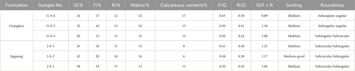
Table 1. Statistical data of clastic components of the Jiaguan and Guankou Formations in the Emei Area.
4.2 Major and trace elemental data
The major and trace element concentrations are listed in Table 2. Among the major elements (Figure 4a), the concentration of SiO2 (47.93%–76.70%, average 55.35%) is the highest, while the concentration of P2O5 is the lowest, ranging from 0.13% to 0.18%, with an average of 0.15%. For the other major elements, the average concentrations, in descending order, is Fe2O3 (3.05%–8.46%, average 6.31%) > CaO (0.59%–9.31%, average 5.04%) > MgO (0.93%–5.87%, average 3.9%) > K2O (1.48%–4.17%, average 3.31%) > Na2O (0.73%–3.43%, average 1.54%) > TiO2 (0.55%–0.85%, average 0.74%). The trends of changes in SiO2 and Na2O were essentially the same, and their concentrations changed slightly in the Penglai Formation, with a large change amplitude in the Jiaguan Formation, first increasing and then decreasing, and then slightly increasing in the Guankou Formation. The changes in the concentrations of A12O3, Fe2O3, K2O, MgO, TiO2, CaO and P2O5 are relatively similar, with their concentrations showing a gradual increase in the Penglai Formation, first increasing and then decreasing in the Jiaguan Formation, and a slight decrease in the Guankou Formation.
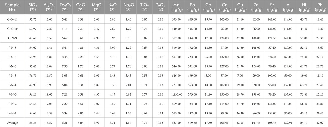
Table 2. Major and trace element compositions of mudstones from the Penglaizhen, Jiaguan, and Guankou Formations in the Emei Area.

Figure 4. Distribution of major (a) and trace elements (b) in mudstones from the Penglaizhen, Jiaguan, and Guankou Formations in the Emei Area.
For the trace elements (Figure 4b), such as Cu, Cr, Ni, Zn, V, Pb, Co, and Ba the same trend in concentration change was observed, with their concentrations gradually increasing in the Penglai Formation, first increasing and then decreasing in the Jiaguang Formation, and slightly decreasing in the Guankou Formation. However, the trend of Sr change is exactly opposite; it gradually decreases from 153.00 to 78.20 μg/g during the Late Jurassic period, fluctuates greatly during the Early Cretaceous period, first increasing from 78.40 to 107.00 μg/g, then decreasing from 107.00 to 78.40 μg/g, and then increasing again from 78.40 to 87.40 μg/g. By the Late Cretaceous period, the Sr concentration in the sediments again rose from 121.50 to 141.00 μg/g. For Mn, the trend of change was even more distinct; several fluctuations were noted in the sedimentary record from the Late Jurassic to the Early Cretaceous, but the range of variation was not significant, reaching its maximum value (1,130.00 μg/g) in the Late Cretaceous.
4.3 Factor analysis
There was a correlation between the different elements, as shown in Table 3, where the correlation coefficients between Ni and V, Zn, Co, Cr, and Mn were all greater than 0.9. The greater the correlation, the more similar the geochemical behaviour of the different elements (Han et al., 2006). Analysing the complex sedimentary process and reconstructing the sequence of environmental changes through the changing trend of each elementis tedious, and may also lead to contradictory conclusions (Chen et al., 1999). Factor analysis is a commonly used mathematical statistical method that groups original variables according to their degree of correlation and reorganises them into a new set of uncorrelated composite indicators, known as common factors (principal components), which can represent the main information in the original data for analysis (Jolliffe, 2002). This method not only scientifically and accurately describes the changing features of the original variables but also achieves dimensionality reduction, simplifies complex problems, and overcomes the one-sidedness of changes in individual variables (Kang et al., 2017; Li et al., 2020). The factors extracted from the research data should account for more than 71% of the total variance to effectively illustrate the potential correlation between the variables (Muller et al., 2008). SPSS software (version 25.0) was used to conduct a factor analysis of the major and trace elements of the sediments in the study profile. The minimum variance contribution value (i.e., the minimum eigenvalue) of the common factor was set to 1. After maximum variance orthogonal rotation, variables with a common factor load absolute value greater than 0.71 were selected (Table 4).
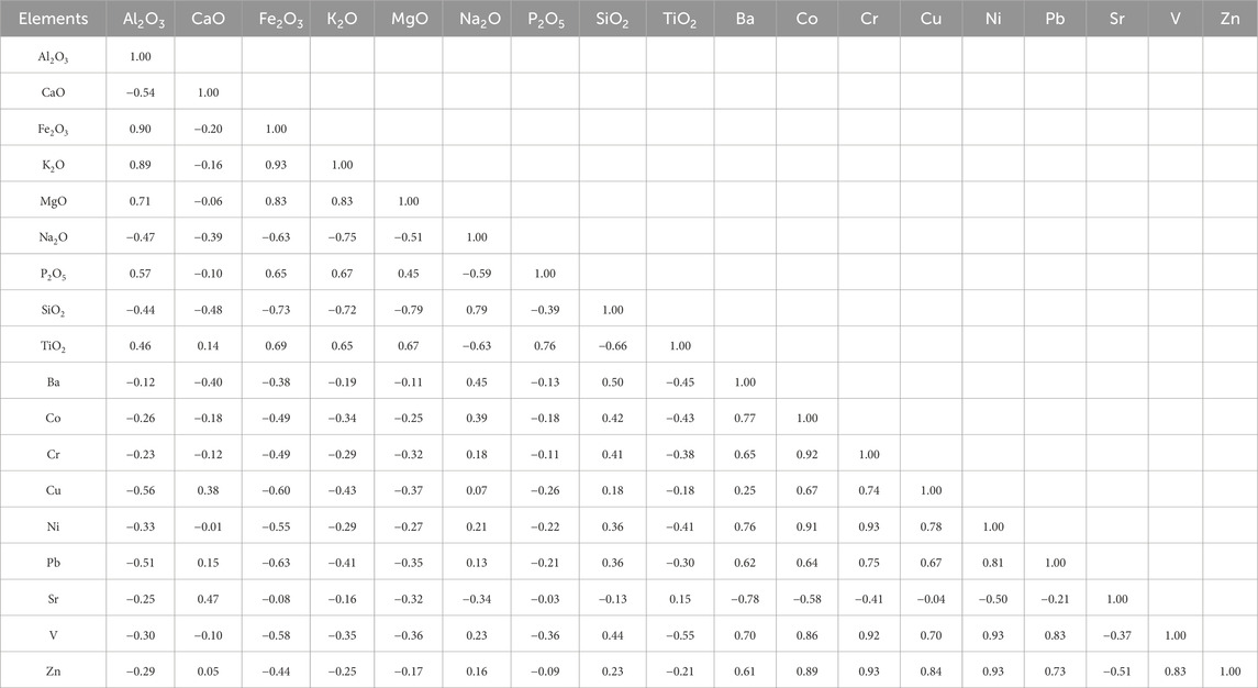
Table 3. Correlation analysis of major and trace elements of mudstones from the Penglaizhen, Jiaguan, and Guankou Formations in Emei Area.
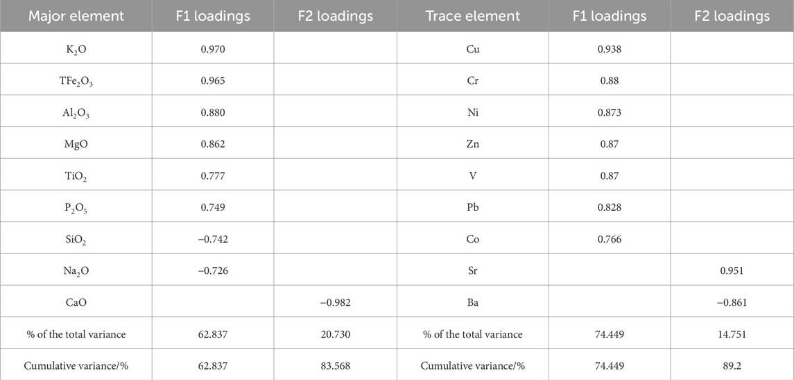
Table 4. Factor analysis of major and trace elements from mudstones in the Penglaizhen, Jiaguan, and Guankou Formations of the Emei Area.
Two factors were extracted as major elements, representing 83.568% of the total variance. Factor 1 (F1) accounts for a large proportion of the variance (62.837%) and is dominated by high positive loadings (0.749–0.970 for K2O, Fe2O3, TiO2, A12O3, P2O5, MgO) and negative loadings for SiO2 (−0.742) and Na2O (−0.726). F2 accounted for 19.366% of the total variance, with one significant factor loading (−0.982) on CaO.
For trace elements, the same two factors were extracted, representing 89.200% of the total variance. Factor 1 (F1) accounted for 74.449% of the total variance, with positive loadings (0.766–0.938) for Cu, Cr, Ni, Zn, V, Pb, and Co. Factor 2 (F2) explained 14.751% of the total variance and was associated with a high positive loading (0.951) for Sr and negative loading (−0.861) for Ba.
4.4 Chemical index of alteration(CIA)
The Chemical index of alteration (CIA) is closely related to temperature and humidity and is an important indicator of the degree of weathering and palaeoclimate analysis in the source area of clastic rocks (Nesbitt and Young, 1989; Young, 2002; Xu and Shao, 2018; Chen et al., 2024; Li et al., 2023). The Formula 1 is as follows:
where CaO* refers to the CaO in silicate minerals. However, the CaO data measured in this study were the sum of silicate, carbonate, and phosphate minerals. Therefore, the value of CaO* is calculated indirectly using the method proposed by McLennan (1993): CaOrest = CaO-(10/3) × P2O5, If CaOrest < Na2O, then CaO* = CaOrest, otherwise CaOrest > Na2O, CaO * = Na2O.
The parent rock becomes more complex during weathering, transportation, and sedimentation. When CIA values are used to determine the palaeoclimate of the source area, rock sorting, sedimentary recycling, pedogenesis, and potassium metasomatism should be excluded. For rock sorting, all samples in this study were mudstones, which effectively excluded the influence of sedimentary differentiation (Xu et al., 2020). Cox et al. (1995) proposed the index of compositional variability (ICV) to determine whether sedimentary recycling occurred in the source area. The specific Formula 2 is as follows:
When ICV>1, it is the first sedimentation (Kamp and Leake, 1985); and when ICV<1, it may have undergone re-cycling and could not be determined as the first sedimentation (Barshad, 1966).
Nesbitt and Young (1982), Nesbitt and Young (1989) proposed that potassium metasomatism in the diagenetic period can be determined by whether the weathering curve of the sample in the A-CN-K diagram (Figure 5) is parallel to the ideal weathering curve of the A-CN line. For a parallel curve, the inference was the absence of potassium metasomatism; a non-parallel curve, indicated potassium metasomatism. In addition, Panahi et al. (2000) proposed a correction formula (Formula 3) for K2O in mudstones undergoing potassium metasomatism.
where m is the proportion of K2O in the parent rock, which is approximately determined by the intersection of the ideal weathering curve parallel to the A-CN line and the CN-K coordinate axis. The corrected CIAcorr formula (Formula 4) is as follows.

Figure 5. A-CN-K ternary diagrams (Fedo et al., 1995) for mudstones from the Penglaizhen, Jiaguan, and Guankou Formations in Emei Area (A: Al2O3; CN: CaO*+Na2O; K: K2O).
According to Formula 1, the CIA values of the Late Jurassic Penglaizhen Formation range from 62.85 to 74.93, with a mean of 68.50. The CIA values of the Early Cretaceous Jiaguan Formation range from 58.76 to 66.73, with a mean of 63.62. The CIA values of the Late Cretaceous Guankou Formation range from 61.64 to 69.92, with a mean of 65.19. The Late Jurassic Penglaizhen Formation has the highest average CIA value, followed by Late Cretaceous Guankou Formation, and the Early Cretaceous Jiaguan Formation. According to formula 2, the ICV values of the mudstone from the Late Jurassic to the Late Cretaceous range from 1.11 to 1.87, all of which are greater than 1 (Table 5). Therefore, it is concluded that all the mudstone samples taken were the first-cycle sediments without a history of recycling. From the A-CN-K diagram (Figure 5), it can be seen that the weathering curve of the selected samples is not parallel to the ideal weathering curve thereby indicating that potassium metasomatism occurred in these rocks, possibly during the diagenetic stage; the determined m value was 0.1281 approximately. After correcting the K2O concentration, CIAcorr was further obtained, and in the Penglaizhen Formation it ranged from 64.55 to 80.62, with an average value of 72.07; in the Jiaguan Formation it ranged from 56.94 to 71.55, with an average value of 66.07; and in the Guankou Formation it ranged from 64.43 to 77.11, with an average value of 69.54. Compared with the uncorrected CIA value, the difference ranges from 0.98 to 6.32, which is not very large, indicating that the potassium metasomatism in these three formations of samples is relatively weak.
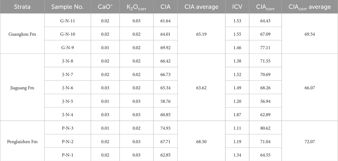
Table 5. Variable data associated with CIA values.
5 Discussion
5.1 Detrital components for indicating paleoclimate
The clastic components of sediments are composed of Q, F, and R and contain information about the climate and structure of the sedimentary period (Liu, 1980). The F/Q ratio represents the climate index, with a larger ratio indicating a drier and colder climate (Chen, 2018). The R/Q ratio represents the structural index, with a larger ratio reflecting stronger changes in tectonic activity in the parent rock area (Chen, 2018). In general, F/Q was greater than R/Q, indicating that climatic factors had a greater influence on sedimentation at that time. The ratio of the relative contents of stable and unstable components is called mineral maturity (Q/F + R), which represents the maturity of detrital components; a larger ratio indicates a higher maturity of detrital components, indicating a longer transport distance (Shi et al., 1995).
The F/Q values of the samples from Jiaguang Formation vary from 0.41 to 0.50 (average: 0.46) (Table 1). The F/Q values of the samples from Guankou Formation are higher, varying in ranges of 0.50–0.63 (average: 0.54), suggesting that the Late Cretaceous palaeoclimate was lower in humidity and temperature than that of the Early Cretaceous. The R/Qvalues of the samples from the Jiaguang and Guankou formations vary from 0.38 to 0.50, which were all less than the F/Q values, indicating that the formation process of Cretaceous sediments was mainly controlled by climatic factors.
The Q/(F + R) values of the samples from the Jiaguang and Guankou Formations vary from 0.89 to 1.25, with an average value of 1.09. It can be concluded that most values are close to 1, with low component maturity (Ge et al., 2015), further suggesting near-provenance deposits, which are consistent with the characteristics of the sandstones observed under the microscope, whose sorting degree is poor and medium, and the grains are subrounded and subangular.
5.2 Factor analysis for indicating paleoclimate
Factor 1 of major and trace elements include Si, Ti, A1, Fe, Cu, Cr, Ni, Zn, V, Pb, Co, P, Mg and Na (Table 4). Si, Ti, A1, Fe, Cu, Cr, Ni, Zn, V, Pb, and Co are elements that are stable in superbiotic environments, occur in terrigenous clastic minerals, and indirectly reflect the amount of terrigenous material input (Shotyk, 1988; Muller et al., 2008; Yang et al., 2014). The variation of these elements is mainly controlled by basin erosion whose intensity is closely related to the degree of basin surface runoff, which in-turn depends on the amount of rainfall in the local climate area, that is, the dry and wet conditions of regional climate (Chen et al., 1999; Yao et al., 2010; Fan, 2010; Yuan and li, 2014). In addition, the higher the concentration of the above elements in the sediments, the more humid is the palaeoclimate inferred to be (Tian and Zhang, 2016). K, P, Mg, and Na are migratory elements that are often used to judge the degree of dryness and weathering of the climate (Zhang et al., 2011). Therefore, F1 represents the intensity of erosion in the basin and reflects changes in dry and wet climates.
Factor 2 for the major and trace elements included Ca, Sr, and Ba (Table 4). Ca, Sr and Ba are migratory elements and alkaline earth metals, which form bicarbonates, chlorides and sulfates into aqueous solutions during the process of epigenesis, and also become major elements in bioclastic sediments under biogenetic processes (Yao et al., 2010). Sr and Ba are chemically and structurally similar to Ca and have similar environmental effects (Cheng et al., 2011). However, the Sr and Ba concentrations have an inverse relationship due to their competition for carbonate ions (Chen et al., 1999). The precipitation factors of calcium carbonate include temperature, pressure (water depth), salinity, and light, among which temperature not only determines the saturation degree of calcium carbonate but also has important significance for biological reproduction (Luo et al., 2008). These elements (Sr, Ba, and Ca) therefore indirectly reflect the temperature changes of climate (Wang et al., 2010b; Tian et al., 2005). The F2 factor, therefore, represents surface deposition under biological action, reflecting temperature changes in the climate.
From the bottom to the top of the Penglaizhen Formation, the F1 and F2 scores from major and trace elements gradually increased from 0.17 to 0.95, −0.83 to 0.76, −1.76 to 0.53, and −0.85 to 1.04, respectively (Figure 6), indicating that the basin erosion and calcium carbonate precipitation increased during this period, further indicating that the Late Jurassic palaeoclimate gradually witnessed an increase in temperature and humidity from the Early to the Late stages. For the Early-Cretaceous-age Jiaguan Formation, the F1 and F2 of major and trace elements has low peak scores of −2.62, −2.47, 0.27 and 0.34, respectively, indicating that an extremely cold and arid climate event occurred during the Early Cretaceous. Except for the peak, the F1 and F2 scores from major and trace elements values range from −0.26 to 0.95, −0.06 to 1.07, 0.33 to 1.30, and 0.22 to 1.14, respectively. For the Late Cretaceous Guankou Formation, the F1 and F2 scores for the major and trace elements range from −0.32 to 0.46, −0.35 to 0.88, −0.42 to −1.02, and −1.11 to −1.44, respectively. The palaeoclimate of the Late Cretaceous was clearly less humid and warm than that of the Early Cretaceous, which is consistent with the results of the aforementioned palaeoclimate indicated by the clastic components.
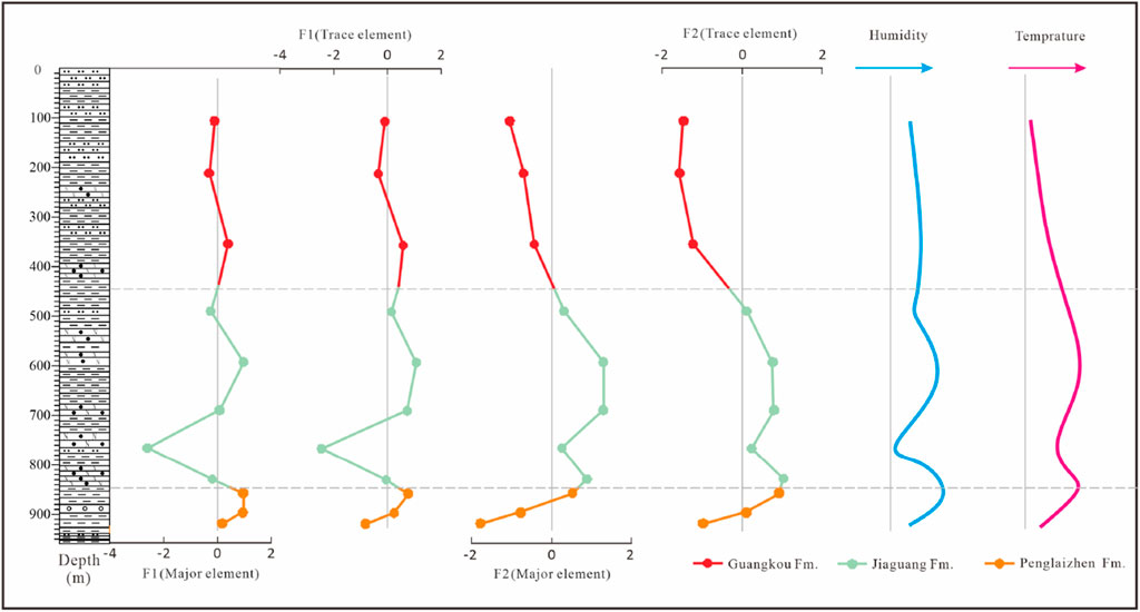
Figure 6. Change curves of F1 and F2 scores for the extraction of major and trace elements of mudstones from the Penglaizhen, Jiaguan, and Guankou Formations in the Emei Area.
5.3 The ratio of elements for indicating paleoclimate
Climatic conditions have a strong control over the transport and sedimentation processes of sediments, thus affecting the degree of sediment enrichment. Therefore, palaeoclimatic conditions can be restored using geochemical element composition characteristics. According to this correspondence between elements and climate, Guan (1992) proposed the value of the climate index (C-value) to represent the degree of dryness and wetness in the palaeoclimate using the Formula 5:
Since then, it has become a widely used palaeoclimatic indicator (Moradi et al., 2016; Shi et al., 2023; Zhang et al., 2022). Qiu et al. (2015) further divided the C-value into five stages indiating different degrees of humidity: C-value >0.8, palaeoclilmate are humid; C-value = 0.6–0.8, semi-humid; C-value = 0.4–0.6, semiarid-semihumid; C-value = 0.2–0.4, semiarid; and C-value <0.2, arid condition.
As shown in Figure 7, the C values from the Late Jurassic age Penglaizhen Formation range from 0.36 to 0.76, being in the semiarid to semihumid stage. In addition, from top to bottom of the Formation, the C value gradually increased, indicating that the palaeoclimate of the Late Jurassic gradually became humid from the Early to Late stages. For the Early-Cretaceous-age Jiaguan Formation, the C values vary from 0.42 to 0.63, indicating semiarid to semihumid conditions. Similar to the factor analysis, there was a minimum C-value (0.42) at the same stratigraphic location, indicating the occurrence of an extremely arid climate event during the Early Cretaceous. Previous studies have also shown that an extreme drought climate occurred during the Early Cretaceous in the Sichuan Basin (Chen, 2009), which may correspond to a global extreme drought event from the Aptian to the Albian during the Cretaceous period (Jenkyos et al., 1994; Stoll and Schrag, 2000). For the Late-Cretaceous-age Gangkou Formation, the C values vary 0.31 to 0.38, being in a semiarid environment. It can be seen that the paleoclimate of the Late Cretaceous was drier than that of the Early Cretaceous, which is consistent with the results obtained from the detrital component characteristics and the factor analysis of major and trace elements. This result is consistent with the conclusions of previous studies on palaeoclimate in Ya ‘an area, Sichuan Basin (Cao et al., 2008; Chen, 2009) and the trend of palaeoclimate change in China (Song, 2011; Xu, et al., 2021).
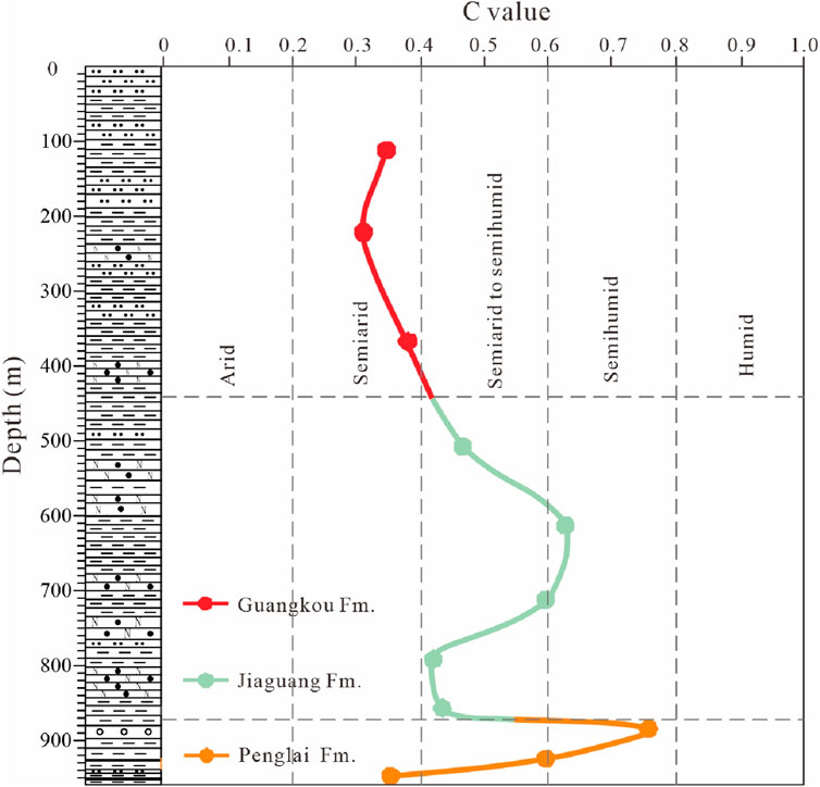
Figure 7. Characteristics of C value changes for mudstones from the Penglaizhen, Jiaguan, and Guankou Formations in the Emei Area.
Since the Cretaceous, there has been no latitudinal movement in the landmasses of South and North China (Chen et al., 1993; Enkin et al., 1992). Palaeomagnetic studies have shown that the palaeo-latitude of the Sichuan Basin has not changed significantly and should be in the middle to low latitudes of the Northern Hemisphere (Jiang et al., 1999). In the Cretaceous, the Sichuan Basin was bordered by the Old Tethys Ocean to the south and the Palaeo-Pacific Ocean to the east, which should have influenced a humid climate; however, the Cretaceous climate was mainly characterised by drought. This is mainly because the Sichuan Basin straddles the then-Northern Hemisphere subtropical high-pressure belt (Jiang, 1996; Cooke et al., 1993), which is mainly controlled by the planetary wind system, resulting in a dry climate in the southwestern Sichuan Basin with a large number of gypsum–salt and desert deposits (Jiang et al., 1999; Jiang, 2003). The paleoclimate of the Late Cretaceous was more arid than that of the Early Cretaceous, which may be related to the rapid uplift of the southeastern coastal mountain range in the eastern regions of Zhejiang, Fujian, and Guangdong caused by the northward and westward subduction of the Indian and Pacific plates and the activation of the Lishui Haifeng Fault in the early Late Cretaceous (Chen, 1997; Qu et al., 2024). In addition, Chen (2008) used the mass balance method to calculate that the height of the southeastern coastal mountains in the early Late Cretaceous reached at least 2,500 m, which likely hindered warm and humid airflow from the east.
5.4 Determination of weathering degree
Chemical weathering is strongly sensitive to climate, with temperature and humidity proposed as the driving factors (Nesbitt and Young, 1982). The chemical index of alteration can be effectively used to assess the degree of chemical weathering in a provenance (Nesbittand Young, 1982). High CIA values reflect a relatively intense degree of chemical weathering, whereas low CIA values reflect a relatively weak degree of chemical weathering (Fedo et al., 1995). Nesbitt and Young (1982) divided it into three stages according to the size of the CIA value: a CIA value of 50–65, low chemical weathering degree; a CIA value of 65–85, moderate chemical weathering degree; and a CIA value of 85–100, strong chemical weathering degree.
The CIAcorr values of the Penglaizhen, Jiaguan, and Guangkou Formations ranged from 55 to 79, with a mean of 67.24 (Table 4), all higher than the average value of the upper crust (UCC: 47.92) (Rudnick and Gao, 2003). In addition, some CIA values are similar to those of glacial clay (60–65), whereas others are similar to the average value of Precambrian Australian shale (PAAS: 70.36) (Taylor and McLennan, 1985) (Figure 8). This indicates that most of the mudstones in the Emei area from the Late Jurassic to Late Cretaceous have a weak-to-moderate weathering degree, and no strong weathering occurred, which is consistent with the view that the sedimentary area observed under the microscope contains more than 10% feldspar clastic particles, medium sorting, and a low grinding degree, reflecting the low maturity of the rock composition.
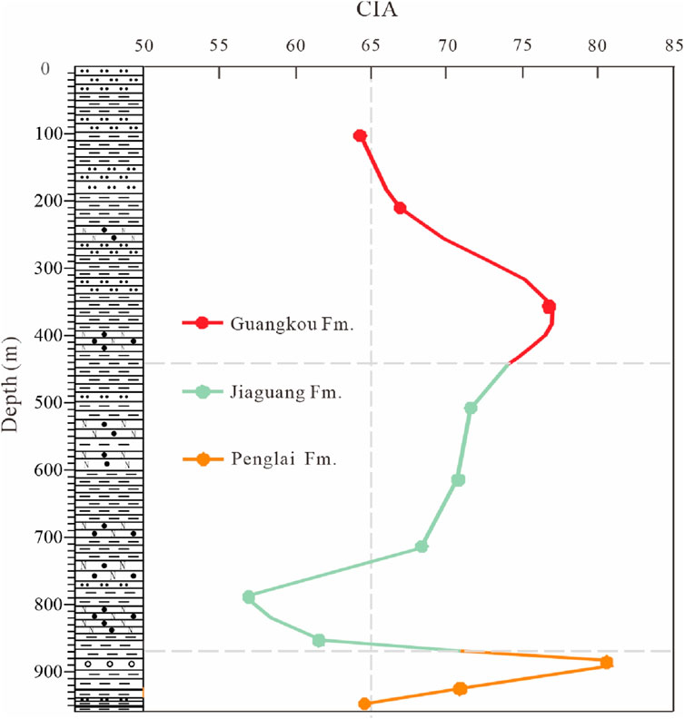
Figure 8. Characteristics of CIAcor value changes for mudstones from the Penglaizhen, Jiaguan, and Guankou Formations in the Emei Area.
6 Conclusion
1) The formation of Cretaceous sediments in the Emei area of the Sichuan Basin was mainly controlled by climatic factors and was only slightly affected by tectonic activities. Moreover, the maturity of the rock clastic compositions is relatively high, indicating distant provenance sources.
2) In the Emei area of the Sichuan Basin, the Late Jurassic palaeoclimate gradually became semiarid to semihumid, the Early Cretaceous palaeoclimate became semiarid to semihumid followed by an extremely dry event, and the Late Cretaceous palaeoclimate was semiarid and more arid than the Early Cretaceous palaeoclimate which is related to the southeastern coastal mountain.
3) From the Late Jurassic to the Late Cretaceous, the degree of chemical weathering of the provenance in the Emei area of the Sichuan Basin was mainly weak to moderate.
Data availability statement
The original contributions presented in the study are included in the article/supplementary material, further inquiries can be directed to the corresponding authors.
Author contributions
SL: Data curation, Formal Analysis, Methodology, Resources, Writing – original draft. FX: Methodology, Resources, Supervision, Validation, Visualization, Writing – review and editing. LS: Formal Analysis, Investigation, Supervision, Validation, Visualization, Writing – review and editing. FZ: Funding acquisition, Project administration, Resources, Supervision, Validation, Writing – review and editing. HM: Formal Analysis, Resources, Validation, Visualization, Writing – review and editing. BX: Formal Analysis, Funding acquisition, Methodology, Resources, Supervision, Writing – review and editing. SS: Formal Analysis, Software, Writing – review and editing.
Funding
The author(s) declare that financial support was received for the research and/or publication of this article. This study was supported by the National Natural Science Foundation of China (Grant No. 42202291), the Fundamental Research Funds for the Central Universities (No. 3142020002, No. 3142021004), and the Construction of the Water Damage Model in the Xishan Coal Power Mining Area (Grant No. 20230767).
Conflict of interest
Author HM was employed by CCTEG Xi’an Research Institute (Group) Co., Ltd.
The remaining authors declare that the research was conducted in the absence of any commercial or financial relationships that could be construed as a potential conflict of interest.
Generative AI statement
The author(s) declare that no Generative AI was used in the creation of this manuscript.
Publisher’s note
All claims expressed in this article are solely those of the authors and do not necessarily represent those of their affiliated organizations, or those of the publisher, the editors and the reviewers. Any product that may be evaluated in this article, or claim that may be made by its manufacturer, is not guaranteed or endorsed by the publisher.
References
Barshad, I. (1966). “The effect of a variation in precipitation on the nature of clay mineral formation in soils from acid and basic igneous rocks,” in Proceedings International Clay Conference, 167–173.
Bodin, S., Meissner, P., Janssen, M. N., Steuber, T., and Mutterlose, J. (2015). Large igneous provinces and organic carbon burial: controls on global temperature and continental weathering during the Early Cretaceous. Glob. Planet. Change 133, 238–253. doi:10.1016/j.gloplacha.2015.09.001
Cao, K., Li, X. H., and Wang, C. S. (2008). Characteristics of Cretaceous system clay minerals and paleoclimate investigation in Sichuan Basin (in Chinese). Acta. Geologica. Sinica. 82 (1), 115–123. doi:10.3321/j.issn:0001-5717.2008.01.014
Chakrapani, G. J. (2005). Major and trace element geochemistry in upper Ganga River in the Himalayas, India. Environ. Geolo gy 48 (2), 189–201. doi:10.1007/s00254-005-1287-1
Chen, X. H., and Lu, T. Q. (2009). Geological fieldwork and investigation guide for Emeishan region. Beijing: Petroleum Industry Press. (in Chinese).
Chen, H. X. (2009). Research of paleoenvironment and paleoclimate of cretaceousin ya’an area of western Sichuan Basin. (Dissertation for Master’s Degree). Chengdu: Chengdu University of Technology, (in Chinese with English abstract).
Chen, J. A., Wan, G. J., Chen, Z. L., and Huang, R. G. (1999). Chemical elements in sediments of Lake Erhai and palaeoclimate evolution. Geochimica (06), 562–570. doi:10.19700/j.0379-1726.1999.06.006 (in Chinese with English abstract).
Chen, L. (2014). Study on the trace fossil assemblage of the Upper Cretaceous Jiaoguan Formation in the Emeishan area, Sichuan Province. (in Chinese with English abstract). (dissertation for master’s degree). Southwest Petroleum University, Chengdu, China.
Chen, P. J. (1997). Coastal mountains of SE China: desertization and saliniferous lakes of Central China during the upper cretaceous. J. Stratigr. (3), 44–54. doi:10.19839/j.cnki.dcxzz.1997.03.003 (in Chinese with English abstract).
Chen, Q. L. (2018). Sedimentary evolution of the late cretaceous in the yongchong basin, jiangxi Province. Beijing: Geological Publishing House.
Chen, T. Y., Lü, B., Li, J. W., Tang, J. M., and Liu, X. (2024). The applicability of Chemical index of Alteration(CIA) to reflect weathering intensity of humid subtropical weathering crust soil. Quat. Sci. 44 (02), 551–562. doi:10.11928/j.issn.1001-7410.2024.02.23 (in Chinese with English abstract).
Chen, Y., Courtillot, V., Cogne, J.-P., Besse, J., Yang, Z., and Enkin, R. (1993). The configuration of asia prior to the collision of India: cretaceous paleomagnetic constraints. J. Geophys. Res. Part B Solid Earth 98, 21927–21941. doi:10.1029/93jb02075
Chen, Y. H. (2008). Late Cretaceous sedimentary responses to the “coast range” and paleoclimate. (in Chinese with English abstract). (dissertation for master’s degree). Chengdu University of Technology, Chengdu, China.
Cheng, A. Y., Yu, J. Q., Zhang, L. S., Liu, Y., and Gao, C. L. (2011). Analysis of toson lake XRF core scanning and application of multivariate statistical methods. J. Salt Lake Res. (01), 20–25. Available online at: http://ir.isl.ac.cn/handle/363002/1189. (in Chinese with English abstract).
Cox, R., Lowe, D. R., and Cullers, R. L. (1995). The influence of sediment recycling and basement composition on evolution of mudrock chemistry in the southwestern United States. Geochimica Cosmochim. Acta 59 (14), 2919–2940. doi:10.1016/0016-7037(95)00185-9
Deng, J. H., Zhang, Y., and Deng, B. (2013). Geological cognition practice tutorial of mount Emei. Beijing: Geological Publishing House, 10–120.
Enkin, R. J., Yang, Z. Y., Chen, Y., and Courtillot, V. E. (1992). Paleomagnetic constraints on the geodynamic history of the major blocks of China from the permian to the present. J. Geophys. Res. Part B Solid Earth 97 (B10), 13953–13989. doi:10.1029/92jb00648
Fan, Z. (2010). Geochemical elments distribution and palacoclimate evolution from a sedimentary drilling in Lake Gas kure. (in Chinese with English abstract). (dissertation for master’s degree). Lanzhou University, Lanzhou, China.
Fedo, C. M., Nesbitt, H. W., and Young, G. M. (1995). Unraveling the effects of potassium metasomatism in sedimentary rocks and paleosols, with implications for paleoweathering conditions and provenance. Geology 23 (10), 921–924. doi:10.1130/0091-7613(1995)023<0921:uteopm>2.3.co;2
Ge, J. W., Zhu, X. M., Pan, R., Lei, Y. C., Zhang, X., and Chen, S. H. (2015). A quantitative porosity evolution model of sandstone for wenchang Formation in huizhou Depression, Pearl river mouth basin: a case study for braided fluvial delta reservoir of HZ-A area. Acta Sedimentol. Sin. 33 (01), 183–193. doi:10.14027/j.cnki.cjxb.2015.01.019 (in Chinese with English abstract).
Geology and Mineral Resources Bureau of Sichuan Province (1991). Regional geological history of sichuan Province. Beijing: Geological Publishing House.
Guan, Y. Z. (1992). The element, clay mineral and depositional environment in horqin sand land. J. Desert Res. (01), 12–18.
Han, Y. M., Du, P. X., Cao, J. J., and Eric, S. P. (2006). Multivariate analysis of heavy metal contamination in urban dusts of Xi’an, Central China. Sci. Total Environ. 355, 176–186. doi:10.1016/j.scitotenv.2005.02.026
Hao, F., Guo, T., and Zhu, Y. (2008). Evidence for multiple stages of oil cracking and thermochemical sulfate reduction in the puguang gas field, Sichuan Basin, China. AAPG Bull. (5), 92. doi:10.1306/01210807090
Hu, B., Wu, X. T., and Pan, L. M. (1991). Ichnocoenoses of the late paleozoic and mesozoic fluvial deposits of Emei area, western sichuan, China. Acta Sedimentol. Sin. (04), 128–135.
Jenkyos, H. C., Gale, A. S., and Corfield, R. M. (1994). Carbon- and oxygen-isotope stratigraphy of the English Chalk and Italian Scaglia and its palaeoclimatic significance. Geol. Mag. 131, 1–34. doi:10.1017/s0016756800010451
Jiang, X. H. (1996). Spato-temporal distribution of the cretaceous deserts in central and eastern China and its climatic significance. Sediment. Facies Palaeogeogr. (02), 42–51.
Jiang, X. S. (2003). Cretaceous desert in China and its paleoclimate. (in Chinese with English abstract). (dissertation for master’s degree). Chengdu University of Technology, Chengdu, China.
Jiang, X. S., Pan, Z. X., and Fu, Q. P. (1999). The variations of palaeowind direction of the Cretaceous desert in the Sichuan Basin and their significance. Sediment. Facies Palaeogeogr. (01), 3–13. doi:10.3969/j.issn.1009-3850.1999.01.001 (in Chinese with English abstract).
Jolliffe, I. T. (2002). Principal component analysis. J. Mark. Res. 87 (4), 513. doi:10.2307/3172953
Kamp, P. C. V. D., and Leake, B. E. (1985). Petrography and geochemistry of feldspathic and mafic sediments of the northeastern Pacific margin. Trans. Roy. Soc. Edin. Earth 76 (04), 411–449. doi:10.1017/S0263593300010646
Kang, X. M., Song, J. M., Yuan, H. M., Duan, L. Q., Li, X. G., Li, N., et al. (2017). Speciation of heavy metals in different grain sizes of Jiaozhou Bay sediments: bioavailability, ecological risk assessment and source analysis on a centennial timescale. Ecotoxicol. Environ. Saf. 143, 296–306. doi:10.1016/j.ecoenv.2017.05.036
Li, C. H. (2016). Study on lithofacies paleogeography of Jurassic in Sichuan Basin. (in Chinese with English abstract). (dissertation for master’s degree). University of Technology, Chengdu, China.
Li, S. X. (2018). Study on stratigraphic classification and paleoclimate of Cretaceous in E’mei. (dissertation for master’s degree). Chengdu University of Technology, Chengdu, China. doi:10.26986/d.cnki.gcdlc.2018.000207
Li, J., Huang, C. M., Yang, G. L., Pan, Y. Y., and Wen, X. Y. (2022). Middle Jurassic climate oscillations from paleosol records of the Sichuan Basin, SW China. J. Palaeogeogr. 11 (01), 97–122. doi:10.1016/j.jop.2022.01.003
Li, Q., Liu, Y., Deng, R. L., Liu, R. S., Song, H. M., Wang, Y., et al. (2020). Combination of tree rings and other paleoclimate proxies to explore the east asian summer monsoon and solar irradiance signals: a case study on the North China plain. Atmosphere 11 (11), 1180. doi:10.3390/atmos11111180
Li, Y. N., Shao, L. Y., Fielding, C. R., Frank, T. D., Wang, D. W., Mu, G. Y., et al. (2023). The chemical index of alteration in Permo-Carboniferous strata in North China as an indicator of environmental and climate change throughout the late Paleozoic Ice Age. Glob. Planet. Change 221, 104035. doi:10.1016/j.gloplacha.2023.104035
Lu, T. Q., Zhang, X. L., and Chen, L. (2013). Dinosaur tracks in vertical sections from the upper cretaceous jiaguan Formation of Emei, Sichuan province. Acta Palaeontol. Sin. 52 (04), 518–525. doi:10.19800/j.cnki.aps.2013.04.010 (in Chinese with English abstract).
Luo, C., Peng, Z. C., Liu, W. G., Zhang, Z. F., He, J. F., Liu, G. J., et al. (2008). Evidence from the lacustrine sediments of lop-nur Lake,Northwest China for the younger dryas event. Earth Sci. (02), 190–196. doi:10.3799/dqkx.2008.025
Mahanipour, A., Mutterlose, J., and Eftekhari, M. (2019). Calcareous nannofossils of the barremian – aptian interval from the southeastern Tethys (zagros basin, west Iran) and their paleoceanographic implications: a record of oceanic anoxic event 1a. Mar. Micropaleontol. 149, 64–74. doi:10.1016/j.marmicro.2019.04.003
Mclennan, S. M. (1993). Weathering and global denudation. J. Geol. 101 (2), 295–303. doi:10.1086/648222
Moradi, A. V., Sari, A., and Akkaya, P. (2016). Geochemistry of the Miocene oil shale (Hançili Formation) in the Çankırı-Çorum Basin, Central Turkey: implications for Paleoclimate conditions, source–area weathering, provenance and tectonic setting. Sediment. Geol. 341 (Jul.15), 289–303. doi:10.1016/j.sedgeo.2016.05.002
Muller, J., Kylander, M., Martinez-Cortizas, A., Wüst, R. A. J., Weiss, D., Blake, K., et al. (2008). The use of principle component analyses in characterising trace and major elemental distribution in a 55 kyr peat deposit in tropical Australia: implications to paleoclimate. Geochim. Cosmochim. Acta 72, 449–463. doi:10.1016/j.gca.2007.09.028
Nesbitt, H. W., and Young, G. M. (1982). Early Proterozoic climates and plate motions inferred from major element chemistry of lutites. Nature 299 (5885), 715–717. doi:10.1038/299715a0
Nesbitt, H. W., and Young, G. M. (1989). Formation and diagenesis of weathering profiles. J. Geol. 97 (2), 129–147. doi:10.1086/629290
Ogg, J. G., Ogg, G. M., and Gradstein, F. M. (2016). A concise geologic time scale 2016. Elsevier Science Ltd, 133–186.
Panahi, A., Rainbird, R. H., and Young, G. M. (2000). Behavior of major and trace elements (including REE) during Paleoproterozoic pedogenesis and diagenetic alteration of an Archean granite near Ville Marie, Quebec, Canada. Geochimica Cosmochim. Acta J. Geochem. Soc. Meteorit. Soc. 64 (13), 2199–2220. doi:10.1016/s0016-7037(99)00420-2
Parrish, J. T. (1993). Climate of the supercontinent pangea. J. Geol. 101 (2), 215–233. doi:10.1086/648217
Qiu, X. W., Liu, C. Y., Wang, F. F., Deng, Y., and Mao, G. Z. (2015). Trace and rare earth element geochemistry of the Upper Triassic mudstones in the southern Ordos Basin, Central China. Geol. J. 50 (4), 399–413. doi:10.1002/gj.2542
Qu, T. Q., Li, S. P., Liu, W. Q., and Chen, L. Q. (2024). Interpretation of the Cretaceous geomorphology in eastern China based on palynological data. J. Palaeogeogr. Ed. 26 (02), 354–372. doi:10.7605/gdlxb.2023.06.081 (in Chinese with English abstract).
Rudnick, R. L., and Gao, S. (2003). “Composition of the continental crust,” in Treatise on geochemistry (Amsterdam: Elsevier), 1-64, 1–64. doi:10.1016/b0-08-043751-6/03016-4
Shi, L., Fan, B. J., Wang, X., Li, Y. T., Huang, F. F., and Dai, X. Y. (2023). Element composition and sedimentary environment of chang 9 shale source rocks in the ordos basin. Geoscience 37 (05), 1254–1263. doi:10.19657/j.geoscience.1000-8527.2023.039 (in Chinese with English abstract).
Shi, Y. Z., Yang, W. J., and Qian, Z. (1995). Geology (in Chinese). Dongying, China: Petroleum University Publishing House, 20–58.
Shotyk, W. (1988). Review of the inorganic geochemistry of peats and peatland waters. Earth Sci. Rev. 25 (2), 95–176. doi:10.1016/0012-8252(88)90067-0
Song, J. C., Hughes, M. H., Ramolia, P. B., and Wells, M. J. (2011). JAAD Grand Rounds quiz. Milia-like papules on upper trunk, neck, and left forehead.J. Am. Acad. Dermatol. 467–469. doi:10.1016/j.jaad.2010.02.042
Stoll, H. M., and Schrag, D. P. (2000). High-resolution stable isotope records from the Upper Cretaceous rocks of Italy and Spain: glacial episodes in a greehouse planet? GSA Bull. 112 (2), 308–309. doi:10.1130/0016-7606(2000)1122.3.co;2
Taylor, S. R., and McLennan, S. M. (1985). The continental crust: its composition and evolution. Blackwell Scientific Publication.
Tian, J. C., and Zhang, X. (2016). Sedimentary geochemistry. Beijing: Geological Publishing House, 62–68.
Tian, X. X., Luo, K. L., Tan, J. A., and Li, R. B. (2005). Analysis on palaeoclimate neighbouring the cretaceous and paleogene boundary in jiayin area, heilongjiang province. J. Palaeogeogr. Ed. (03), 425–432. doi:10.3969/j.issn.1671-1505.2005.03.013 (in Chinese with English abstract).
Wang, S. C., Cao, K., and Huang, Y. J. (2009). Sedimentary record and cretaceous earth surface system changes. Earth Sci. Front. 16 (05), 1–14.
Wang, S. S., Cao, Z. M., Lan, D. Z., and Zheng, Z. C. (2010). Geochemical characteristics of sediment of pearl river estuary and its paleoenvironmental evolution. Earth Sci. (02), 261–267. doi:10.3799/dqkx.2010.026 (in Chinese with English abstract).
Wang, Y. B., and Xu, H. J. (2001). Relations between evolution of sedimentary cycles and tectonic uplift around Sichuan Basin from Jurassic to Early Cretaceous. Earth Sci. (03), 241–246. doi:10.3321/j.issn:1000-2383.2001.03.004 (in Chinese with English abstract).
Wang, Y. D., Hang, Q. S., Li, G., Xie, X. P., and Huang, Q. S. (2010). The terrestrial triassic and jurassic systems in the Sichuan Basin, China. Hefei: University of Science and Technology of China Press.
Wang, Y. D., Huang, C. M., Sun, B. N., Quan, C., Wu, J. Y., and Lin, Z. C. (2014). Paleo-CO 2 variation trends and the Cretaceous greenhouse climate. Earth-Science Rev. 129, 136–147. doi:10.1016/j.earscirev.2013.11.001
Wilf, P., Johnson, K. R., and Huber, B. T. (2003). Correlated terrestrial and marine evidence for global climate changes before mass extinction atthe Cretaceous-Paleogene boundary. Proc. Natl. Acad. Sci. U. S. A. 100 (2), 599–604. doi:10.1073/pnas.0234701100
Xu, B., Xiang, F., and Li, S. X. (2021). Distribution characteristics and paleo-climatic significance of continental climate-sensitive sediments in the Late Cretaceous in China. Coal Geol. and Explor. 49 (5), 190–199. doi:10.3969/j.issn.1001-1986.2021.05.021
Xu, X. T., and Shao, L. Y. (2018). Limiting factors in utilization of chemical index of alteration of mudstones to quantify the degree of weathering in provenance. J. Palaeogeogr. Ed. (03), 515–522. doi:10.7605/gdlxb.2018.03.038 (in Chinese with English abstract).
Xu, X. T., Shao, L. Y., Lan, Bo., Wang, S., Jason, H., Qin, J. Y., et al. (2020). Continental chemical weathering during the early cretaceous oceanic anoxic event (OAE1b): a case study from the fuxin fluvio-lacustrine basin, liaoning province, NE China. J. Palaeogeogr. 9 (1), 12. doi:10.1186/s42501-020-00056-y
Yang, Y., Wang, R. J., Liu, J., Zhao, Y., Yang, Z. Y., Weng, C. Y., et al. (2014). Element geochemistry of lacustrine sediments in Lop Nur and their environmental significance over the past 45 ka BP. Mar. Geol. and Quat. Geol. 34 (04), 133–144.
Yao, Z. Q., Liu, Y. G., Wang, K. S., and Shi, X. F. (2010). Millennial-scale paleoenvironment change during the last glacial period recorded by geochemical variations in the Japan sea. Bull. Mineral., Petrol. Geochem. 29 (02), 119–126. doi:10.3969/j.issn.1007-2802.2010.02.002 (in Chinese with English abstract).
Young, M. G. (2002). Geochemical investigation of a neoproterozoic glacial unit: the mineral fork Formation in the wasatch range, Utah. Geol. Soc. Am. Bull. 114 (4), 387–399. doi:10.1130/0016-7606(2002)114<0387:gioang>2.0.co;2
Yuan, S. Y., and Li, C. A. (2014). Study on sediment provenances in jianghan basin since quaternary based on factorial analysis. Geoscience 28 (05), 980–985. doi:10.3969/j.issn.1000-8527.2014.05.013 (in Chinese with English abstract).
Zhang, T. F., Cheng, X. Y., Wang, S. Y., Miao, P., and Ao, C. (2022). Middle jurassic - early cretaceous drastic paleoenvironmental changes in the ordos basin: constraints on sandstone-type uranium mineralization. Ore Geol. Rev. J. Compr. Stud. Ore Genesis Ore Explor. 142, 104652. doi:10.1016/j.oregeorev.2021.104652
Keywords: Emei area, Late Jurassic-Cretaceous, paleoclimate, factor analysis, chemical alteration index after correction (CIAcorr)
Citation: Li S, Xiang F, Shao L, Zhao F, Ma H, Xu B and Sun S (2025) Palaeoclimatic characteristics of the Late Jurassic-Cretaceous in Emei area, Sichuan Basin, China. Front. Earth Sci. 13:1607066. doi: 10.3389/feart.2025.1607066
Received: 07 April 2025; Accepted: 13 May 2025;
Published: 09 June 2025.
Edited by:
Binbin Yang, Xuchang University, ChinaReviewed by:
Dongdong Wang, Shandong University of Science and Technology, ChinaHaihai Hou, Liaoning Technical University, China
Copyright © 2025 Li, Xiang, Shao, Zhao, Ma, Xu and Sun. This is an open-access article distributed under the terms of the Creative Commons Attribution License (CC BY). The use, distribution or reproduction in other forums is permitted, provided the original author(s) and the copyright owner(s) are credited and that the original publication in this journal is cited, in accordance with accepted academic practice. No use, distribution or reproduction is permitted which does not comply with these terms.
*Correspondence: Fang Xiang, Y2R4aWFuZ2ZhbmdAMTI2LmNvbQ==; Bin Xu, amluemlnYW9mZW5nQDEyNi5jb20=