Abstract
The Mesozoic volcanic reservoirs in Qiqikou Sag are complex and diverse. Identifying the characteristics and main controlling factors of high-quality volcanic reservoirs is the key to improve the reserves and production of oil and gas in this area. The establishment of volcanic rock development model provides a reference for further study of volcanic reservoirs. Through core observation, thin section identification, pore permeability and pore structure analysis of volcanic reservoir, combined with production data, on the basis of clarifying reservoir characteristics, the main controlling factors and development modes of high-quality reservoir development are analyzed. The results show that the Mesozoic in Qikou Sag mainly develops neutral andesite and basic basalt of overflow facies, followed by volcanic breccia and tuff of explosive facies. On the whole, the volcanic rock reservoirs belong to high porosity-low permeability and medium porosity-low permeability reservoirs. The physical properties of the andesite reservoir in the overflow phase are the best, showing the characteristics of high porosity-medium permeability. The reservoir space is dominated by secondary pores and fractures, among which dissolution pores are the most important reservoir space types of Mesozoic volcanic reservoirs. Favorable lithofacies and lithology are the foundation for the development of high-quality reservoirs. Favorable lithofacies and lithology are the foundation for the development of high-quality reservoirs, while weathering and dissolution are the key factors for the development of high-quality reservoirs. Fractures further improve the storage performance of igneous rock reservoirs. The dissolution of soluble minerals or volcanic ash in volcanic rocks that have undergone weathering and denudation for a long time produces a large number of secondary dissolution pores. The development of fractures further improves the reservoir physical properties and eventually develops into a weathering crust reservoir. The volcanic rocks far away from the weathering crust increase the reservoir physical properties through the later structural fractures and develop into the inner reservoir.
1 Introduction
As one of the most significant unconventional hydrocarbon resources, igneous rock reservoirs have emerged as a new frontier in global oil and gas exploration (Wang et al., 2021; Zhang et al., 2024; Zhi et al., 2024). To date, more than 300 igneous rock-associated oil and gas reservoirs have been discovered in over 100 countries worldwide, underscoring their substantial potential as a hydrocarbon resource (Tang et al., 2020; Wang et al., 2023; Fu et al., 2024). Multiple layers of Mesozoic volcanic rocks are produced and widely distributed in the Qikou Sag of the Bohai Bay Basin. Multiple drilling wells, including the Northern Dagang Buried hill GG1507 well, Qibei Slope QG8 well, B60-56 well, and Q57 well, within the depression, have yielded industrial oil flows. Igneous rock oil and gas reservoirs have also been discovered in the neighboring weathered shop and Zaobei areas, indicating enormous exploration potential for volcanic rock oil and gas resources in the Qikou Sag and its surrounding areas. Preliminary exploration has shown that the key to the formation of high-quality volcanic reservoirs in the Mesozoic era of the Qikou Sag lies in the development of a large number of dissolution pores, indicating that the volcanic rocks have undergone strong fluid transformation (Fu et al., 2010). However, despite these advancements, substantial breakthroughs in the exploration of Mesozoic igneous rock oil and gas within the Qikou Sag remain elusive, and large-scale accumulations have yet to be identified. The primary challenge lies in the complex formation conditions of igneous rock oil and gas reservoirs, particularly the reservoir conditions. The characteristics of igneous rock reservoirs play a pivotal role in controlling the accumulation and distribution of oil and gas (Niu et al., 2024). In the Qikou Sag, igneous rock reservoir spaces are highly diverse and can be categorized into three main types based on morphological characteristics: primary porosity, secondary porosity, and fractures. igneous rock reservoirs of different lithologies exhibit significant variations in their reservoir space types. For instance, some lava flows develop primary pores, while volcanic breccias and tuffs predominantly develop secondary dissolution pores.
The development of igneous rock reservoirs is controlled by many factors, such as lithology, lithofacies, tectonism, weathering leaching and diagenesis. These influencing factors also play a very different role in different regions and different stages of igneous rock evolution. The main controlling factors of igneous reservoir development can be divided into primary factors and secondary factors. The primary factors include lithology, lithofacies, eruption environment and volcanic edifice distribution. Lithology and lithofacies not only control the development of primary pores, but also affect the formation and evolution of secondary pores. Due to the existence of primary pores, some overflow lavas greatly increase the reservoir properties. For pyroclastic rocks, especially volcanic breccia, intergranular pores and condensation contraction joints are developed to provide volcanic reservoir storage performance and seepage capacity. Different lithology volcanic rocks have different fracture-forming ability. Relatively speaking, andesite and tuff can produce cracks under lower stress. Secondary factors include structure, weathering and leaching. Volcanic oil and gas reservoirs in Qikou Sag are mainly distributed in structural belts with strong tectonism and well-developed fractures. Tectonic action is a necessary factor to improve the permeability of volcanic rock reservoirs. The primary volcanic rock reservoirs basically have no seepage capacity. Under the tectonic stress, the volcanic rocks produce structural fractures, communicate the originally closed pores, and also provide seepage channels for later fluid dissolution. Weathering and leaching is an important factor affecting reservoir performance. Volcanic rocks may become effective reservoirs only after weathering and leaching. A large number of primary pores formed by volcanic eruptions are not connected. Weathering and leaching can cause weathering and dissolution pores and weathering cracks in the reservoirs near the weathering crust, so that the pores are connected to form effective reservoirs.
The lithology and lithofacies of Mesozoic volcanic rocks in Qikou Sag are complex, and the long-term weathering and leaching and multi-stage structural transformation make the volcanic reservoir heterogeneity strong. The exploration practice shows that the gas content and productivity of drilling in different well intervals with close distance are quite different. Therefore, it is urgent to find out the types and characteristics of the Mesozoic high-quality volcanic reservoirs in the study area, and to clarify the main controlling factors of the development of high-quality volcanic reservoirs. On the basis of summarizing the previous research results, combined with production data and experimental test analysis, this paper studies the characteristics, main controlling factors and development mode of high-quality volcanic reservoirs. The research results are expected to provide geological basis for predicting the distribution of high-quality volcanic reservoirs in Qikou sag and guiding the next exploration and deployment.
2 Geological setting
The Huanghua Sag, situated in the central and northern regions of the Bohai Bay Basin, is bounded by the Cangxian Uplift to the west and the Chengning Uplift and Haizhong Uplift to the east. It is located south of the Yanshanian Fold Belt and north of the Linqing Sag, forming a Mesozoic-Cenozoic rift basin superimposed on the North China Platform basement. The Huanghua Depression extends in a north northeast to south southwest direction, with an overall structural pattern of northeast distribution and alternating concave and convex features (Qu et al., 2008). During the Mesozoic, significant lithospheric thinning in the Huanghua Sag area triggered asthenospheric upwelling and intense magmatic activity, resulting in the widespread development of igneous rocks within the basin (Du et al., 1999). The Huanghua Sag has been shaped by multiple tectonic events, including the Triassic Indosinian movement, the Jurassic and Cretaceous Yanshanian movements, and the Cenozoic Himalayan tectonism. These events have led to the formation of over 20 buried hill zones (Meng et al., 2021). igneous rocks in the region are predominantly distributed within the Mesozoic buried hills. The Qikou Sag, located in the central and northern parts of the Huanghua Sag, is the largest oil-producing depression within the region, boasting abundant oil and gas resources (Figure 1). Mesozoic igneous rocks are extensively distributed across the Qikou Sag. This study focuses on the characteristics of igneous rock reservoirs and the main controlling factors for reservoir formation within four key structural belts: the Northern Dagang buried hill tectonic belt, the Southern Dagang buried hill tectonic belt, the Qibei slope, and the Kou Village-Yangsanmu buried hill tectonic belt. Drilling shows that the Qikou Sag has developed a series of strata from top to bottom, including the Neogene, Paleogene, Cretaceous, Jurassic, Permian, Carboniferous, and Ordovician. Among them, the Mesozoic Cretaceous has developed thick volcanic rocks mainly composed of andesite and basalt.
FIGURE 1

Regional structural map and stratigraphic characteristics of Qikou Sag, Bohai Bay Basin.
3 Samples and experiments
In this study, 11 igneous rock core samples from wells in the Mesozoic of the Qikou Sag were observed and described in detail. Additionally, 112 igneous rock core samples were collected from 11 wells for comprehensive experimental analysis, focusing on lithology, reservoir properties, and geochemistry. All 112 core samples are from the Mesozoic strata. Among the 11 wells, Well GG1507 is located in Northern Dagang; The K9 well, K12 well, K23 well, K36 well, K39 well, Y23 well, and X6 well are located in the Kou Village Xianzhuang structural belt; The QG2 well, Q107-1well, and QG1601 well are located in the Southern Dagang structural zone. Qibei Buried hill lacks block samples, but there are rock cuttings from BT1 well as supplements, and comparative analysis is conducted based on logging data.
The rock slices were identified by Olympus microscope, and the lithology, minerals, pores and other characteristics of volcanic rock samples were analyzed. The samples of different lithology were selected for subsequent experimental analysis of reservoir physical properties and pore structure.
Rock physical properties (porosity, permeability) were completed in Northeast Petroleum University. The experimental equipment is PoroPDP-200 overburden pressure porosity and permeability instrument of American core company, and the experimental test is carried out according to the national standard of SY/T5336-1996. After the sample was washed and dried, 26 bulk rock samples were used at a temperature of 25 °C. The porosity of each sample was measured and calculated according to Boyle‘s law, and the permeability was measured by unsteady state method. Three sets of permeability data were measured for each rock sample and the average permeability of each sample was calculated.
The nuclear magnetic resonance (NMR) experiment was completed in Northeast Petroleum University. The core nuclear magnetic resonance measurement uses the GeoSpec2 nuclear magnetic resonance core analyzer produced by the British resonance instrument company. The main working parameters are: the test temperature is 35 °C, the operating frequency is 2 MHz. The experiment follows the industry standard SY/T6490-2014′Laboratory measurement specification for nuclear magnetic resonance parameters of rock samples’. Firstly, 19 rock samples were dried and vacuumized to fully remove the residual gas and saturated distilled water. Then, nuclear magnetic resonance (NMR) resonance core analysis was used for NMR measurement, and the saturated echo signal was measured. The core samples were centrifuged by a high-speed centrifuge at a speed of 10,000 r/min and a centrifugation time of 120 min. Then, nuclear magnetic resonance (NMR) resonance core analysis was used for NMR measurement, and the echo signal of the centrifugal state was measured. Finally, the T2 spectrum inversion is performed on the original data of the core saturation state and the centrifugal state to obtain the T2 spectrum distribution, and the important parameters such as nuclear magnetic porosity and geometric mean are calculated.
The full stress-strain test of rock triaxial compression deformation was completed in Northeast Petroleum University. The experiment follows the national standard ‘Engineering rock mass test method standard GB/T 50,266–99′and ‘ISRM-CLT1 recommended method for measuring uniaxial compressive strength and deformation properties of rock materials’. In the experimental environment with a temperature of about 25° C and a humidity of about 50%, 13 test samples were tested to simulate the mechanical deformation characteristics of rocks at different depths, including rock fracture strength, fracture mode, brittleness characteristics, and total stress-strain relationship (including axial strain and radial strain). And test static mechanical parameters, including rock peak fracture strength, elastic modulus, Poisson‘s ratio, etc.
4 Results
4.1 Lithology and lithofacies of igneous rocks
The rock types and lithology of igneous rocks serve as the fundamental basis for lithofacies classification and reservoir studies (Shang et al., 2024). Influenced by factors such as volcanic eruption environment, eruption mode, magma composition, tectonic movements, and diagenesis, igneous rocks exhibit highly complex and diverse lithologies, posing significant challenges for identification and classification (Mu et al., 2015; Yin et al., 2023; Li, 2024; Xu et al., 2024). Based on well logging data, core observations, and thin section analysis, the Mesozoic igneous rock lithology in the Qikou area has been systematically determined. The igneous rocks in the study area can be broadly categorized into two main types: volcanic lava and volcanic clastic rocks. Volcanic lavas in the study area are further subdivided into two subtypes: basalt and andesite. Basalt typically exhibits a porphyritic texture, with phenocrysts predominantly composed of tabular basic plagioclase and granular pyroxene. In the QG2 well, ophitic basalt phenocrysts show evidence of serpentinized olivine. Andesite is characterized by short-columnar neutral plagioclase and amphibole phenocrysts, with a porphyritic structure. In the Y28 well, some andesite matrices are altered to calcite. Volcanic clastic rocks include tuff and volcanic breccia. Tuff displays a volcanic clastic texture, with volcanic fragments primarily consisting of crystals, glass shards, and rock fragments, embedded in a fine-grained volcanic ash matrix. Volcanic breccia is predominantly composed of rock fragments, with minor amounts of crystal and glass shards, cemented by volcanic ash or finer volcanic material. In the X6 well, andesitic rock fragments are observed. The Mesozoic igneous rocks in the Qikou Sag are predominantly intermediate to basic in composition (The number of samples is 112). Basalt and andesite are the most developed lithologies, accounting for approximately 43% and 27% of the total lithology, respectively. Tuff and volcanic breccia follow, with proportions of approximately 24% and 6%, respectively (Figure 2a).
FIGURE 2

(a) Lithology Pie Chart (b) Lithofacies Pie Chart. Lithology and Lithofacies Statistics of Mesozoic volcanic rocks in the Qikou Sag.
According to the “Lithology-Texture-Origin” volcanic lithofacies classification scheme proposed by Wang Pujun (Wang et al., 2003), the Mesozoic volcanic lithofacies types in the study area include explosive facies, overflow facies, volcanic sedimentary facies, and volcanic conduit facies. The intermediate-basic overflow facies is subdivided into upper and middle-lower subfacies, while the explosive facies consists mainly of fallout and pyroclastic flow subfacies. The Mesozoic igneous rocks in the study area are primarily composed of the middle-lower subfacies of the intermediate-basic overflow facies (45%), followed by the upper subfacies of the intermediate-basic overflow facies (25%), the fall-out subfacies of the explosive facies (23%), and the pyroclastic flow subfacies (7%) (Figure 2b).
4.2 Reservoir space types
Core observation and casting thin sections show that the pore fracture system of volcanic reservoirs in the Qikou Sag is complex, mainly consisting of dissolution pores and fractures, which are important types of reservoir spaces in the study area. Based on core observations and thin section analysis, the reservoir spaces in the Qikou Sag igneous rocks can be classified into three main types: primary porosity, secondary porosity, and fractures. Primary porosity in the igneous rock reservoirs of the study area primarily consists of vesicles and intragranular pores (Figure 3a). Vesicles are often isolated and exhibit various shapes, including round, elliptical, linear, and irregular forms, with significant variations in size. These vesicles are typically evenly distributed, though some remain isolated and non-communicating. Common minerals such as quartz, chlorite, and zeolite frequently fill these vesicles. Vesicles are most developed at the top of each eruption cycle, with some elongated in the direction of lava flow. Secondary porosity is mainly formed by dissolution, resulting in dissolution pores, and pores that are later filled with secondary minerals, termed residual filling pores. Dissolution pores are the most developed pore type in the igneous rock reservoirs of the study area, occurring in all types of igneous rocks. Based on the location of the dissolution pores, these can be further divided into intragranular dissolution pores and matrix dissolution pores (Figures 3c–e). Intragranular dissolution pores have irregular pore shapes; when minerals are completely dissolved, the original crystal structure may remain apparent. These pores are mainly located within crystals and tend to have good connectivity (Figures 3b–e). Matrix dissolution pores are small and sieve-like in shape, primarily formed by the dissolution of fine-grained volcanic ash in the matrix of tuff. These pores are tiny in diameter but numerous, and exhibit certain connectivity (Figures 3c–e). The connectivity of dissolution pores is influenced by factors such as mineral composition, dissolution intensity, and the degree of primary porosity development. Residual filling pores occur when vesicles are incompletely filled by secondary minerals, leaving residual voids. These pores are observed in volcanic breccia at well X6 (Figure 3f).
FIGURE 3

(a) GG1507 well, 2038.08 m, basalt; (b) X6 well, 1792.00 m, volcanic breccia; (c) K23 well, 1908.68 m, tuff; (d) QG2 well, 2322.00 m, basalt; (e) K36 well, 1689.70 m, andesite; (f) X6 well, 1784.80 m, volcanic breccia; (g) K23 well, 1902.44 m, tuff; (h) Y23 well, 1530.15 m, tuff; (i) Q107-1 well, 3117.70 m, volcanic breccia. Different Types of Reservoir Spaces in Igneous Rock Reservoirs.
Fractures in the study area are categorized into structural fractures and dissolution fractures, both of which are well developed and play a crucial role in connecting pores of different scales, forming the primary conduits for oil and gas flow and significantly enhancing reservoir permeability. Structural fractures: These are predominantly high-angle and oblique fractures, often extensively filled with minerals. They are characterized by their straightness, long extension, and deep cutting. Under the microscope, structural fractures are observed to cut through minerals (Figure 3g). Dissolution fractures: These fractures are formed through the dissolution of easily soluble minerals along structural fractures and intergranular fractures. They are commonly found in volcanic breccia and tuff. The fracture surfaces exhibit irregular dissolution edges and intersect with other pores and fractures, demonstrating good connectivity (Figures 3H,I).
4.3 Reservoir properties
The lithology of igneous rocks in Qikou Sag is complex and diverse, and there are obvious differences in reservoir physical properties of igneous rock reservoirs of different rock types. The reservoir capacity of igneous rock reservoir determines whether oil and gas can accumulate (Huang et al., 2023). Therefore, it is very important to find out the reservoir physical properties of different types of igneous rock reservoirs and clarify the types of high-quality igneous rock reservoirs for the exploration of igneous rock reservoirs in the study area (Li et al., 2023). Referring to the standard of classification and evaluation of igneous rock reservoirs in China’s oil and gas industry standard (SY/T6285-2011), the igneous rock reservoirs in Qikou sag are divided into five types according to the characteristics of porosity and permeability:
Type I Reservoirs: φ ≥ 15%, K ≥ 10 mD.
Type II Reservoirs: 10% ≤ φ < 15%, 5 mD ≤ K < 10 mD.
Type III Reservoirs: 5% ≤ φ < 10%, 1 mD ≤ K < 5 mD.
Type IV Reservoirs: 3% ≤ φ < 5%, 0.1 mD ≤ K < 1 mD.
Type V Reservoirs: φ < 3%, K < 0.1 mD (Figure 4).
FIGURE 4

Porosity and permeability distribution map of mesozoic igneous rocks in the qikou sag.
In the Qikou Sag, the lithology of the Mesozoic reservoirs consists of four types: andesite, tuff, basalt, and volcanic breccia. Andesite primarily forms Type I Reservoirs, the porosity is between 22.453% and 25.968%, and the permeability is between 0.8008 and 5.3556mD. while in Ignimbrite, approximately 30% of reservoirs are classified as Type I, 60% as Type II, and Type IV and V reservoirs are not well-developed. Its porosity is between 3.936% and 20.789%, and its permeability is between 0.0015 and 0.9422mD In Basalt, around 60% are Type II Reservoirs, and 25% are Type III Reservoirs, with limited development of Type IV and V reservoirs. The porosity is between 3.422% and 13.714%, and the permeability is between 0.0025 and 0.4862mD. Volcanic breccia is mainly of type I and II reservoirs, with porosity ranging from 12.1% to 17.715% and permeability ranging from 0.037 to 0.2893mD (Figure 5). The favorable reservoir areas in the Mesozoic include the Southern Dagang Structural Zone, Northern Dagang Structural Zone, and Qibei Structural Zone, where the main reservoir types are medium-basic massive lava and Ignimbrite. The reservoir spaces are primarily formed by intracrystalline dissolution pores, matrix dissolution pores, and fractures. The Yangsanmu, Xianzhuang, and Kou Village Structural Zones also have medium-basic massive lava and Ignimbrite reservoirs, but with additional dissolution fractures and tectonic fractures enhancing the reservoir properties.
FIGURE 5
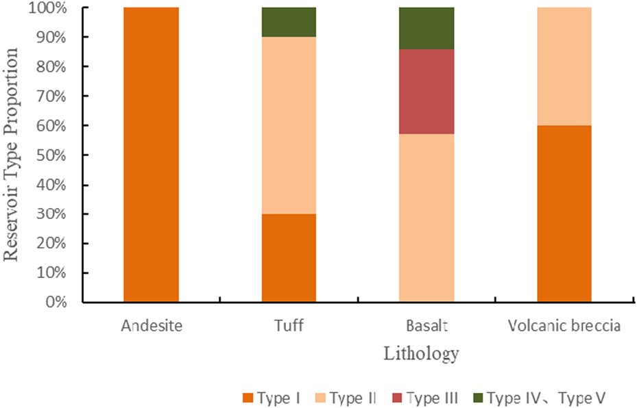
Proportional distribution of reservoir types for different lithologies in mesozoic igneous rocks of the qikou sag.
4.4 Reservoir pore structure
Nuclear magnetic resonance (NMR) experiments were systematically conducted on four representative igneous rock samples from the Middle Jurassic in the Qikou Sag, including andesite, tuff, volcanic breccia, and basalt. These experiments aimed to qualitatively and quantitatively characterize the pore structure types and their distribution patterns within the volcanic reservoirs. Based on the NMR curve morphology, the pore structures were classified into three distinct types: monomodal (Type I), continuous bimodal (Type II), and discontinuous bimodal (Type III). These classifications reflect fundamental differences in pore size distributions, which were further categorized into three groups: small pores (<1 μm), medium pores (1–50 μm), and large pores (>50 μm). A single peak reflects a single pore type, with a relatively concentrated pore size distribution. A continuous double peak reflects strong dissolution, with a large span of pore size. A discontinuous double peak reflects two relatively concentrated pore size distributions, but there is a gap between the two.
The NMR curve of andesite and tuff samples in the Qikou sag area is type II, with two continuous peaks (Figures 6): the left peak is located in the pore size distribution of the small hole, and the corresponding pore size is between 0.1 and 0.5μm; the pore size corresponding to the right peak is between 3 and 10μm, indicating the development of mesopores and macropores. The peak value of NMR curve (Figures 6a,b) of andesite and tuff is on the right, and the curve value of 0.01–100 μm pore size area is not zero, and the pore size distribution range changes greatly, indicating that andesite and tuff are mainly small and medium pores, and large pores are developed, which has good reservoir physical properties. The NMR curves of andesite and tuff are continuous, indicating that the primary pores of andesite undergo strong weathering and dissolution. The dissolution fluid not only connects the pores, but also dissolves and expands the pores, so that the andesite reservoir develops pores with different pore sizes of small pores, medium pores and large pores.
FIGURE 6

(a) K36-1696.42 Andesite (b) K23-1902.44 Tuff. (c) QG2-2319.30 Basalt (d) Q107-1-3117.7 Volcanic Agglomerate. Nuclear Magnetic Resonance Curves of igneous rock Samples.
In contrast, basalt samples display Type III NMR curves (Figure 6c), featuring two discontinuous peaks. The left peak corresponds to small pores with diameters around 30 nm, while the right peak represents small-to-medium pores with diameters around 1 μm. The significantly lower amplitude of the right peak compared to the left peak indicates a predominance of small pores, with limited development of medium pores and an absence of large pores. The discontinuity between the peaks is attributed to the combined effects of dissolution and tectonic activity. Dissolution processes primarily generated small-diameter pores, while tectonic fracturing created a limited number of larger fractures, resulting in a bimodal but discontinuous pore size distribution.
Volcanic breccia samples exhibit Type I NMR curves (Figure 6d), characterized by a single peak corresponding to small pores with diameters ranging from 1 to 800 nm.
5 Main controlling factors of high-quality reservoirs
The viability of igneous rocks as effective reservoirs is contingent upon a multitude of factors. As delineated in the preceding analysis, the development of high-quality igneous rock reservoirs within the Mesozoic strata of the Qikou Sag is predominantly governed by three factors: lithology and lithofacies, weathering, and structural modifications coupled with dissolution phenomena. Specifically, advantageous lithology and lithofacies are the fundamental prerequisite for the development of high-quality reservoirs. Weathering emerges as the pivotal factor in the development of high-quality reservoirs, while the synergistic effects of fracturing and dissolution processes significantly augment the reservoir potential of volcanic formations.
5.1 Favorable lithofacies and lithology as the basis for the development of high-quality reservoirs
Lithology and lithofacies are the internal factors and basis for determining the development of Mesozoic volcanic reservoirs in Qikou Sag, which fundamentally determine the degree and scale of reservoir development (Jiang et al., 2012). In addition, the lithology and lithofacies not only control the development of primary pores, but also affect the degree of dissolution and development of structural fractures in the later stage of the rock, thus determining the reservoir performance and effectiveness of the reservoir. In the Qikou sag area, the lithology and lithofacies are the decisive basis for the later transformation. Logging interpretation of Mesozoic volcanic rocks in Qikou sag is statistically compared (Figure 7a). It is found that the neutral overflow facies andesite is the most prominent in the oil producing section, and the total thickness of oil layer and gas layer is 55 m (Figure 7b), followed by the explosive facies tuff. In addition, there are thick possible oil and gas layers in the basic overflow facies basalt test oil layer, which has great potential and is the main target lithology for later exploration.
FIGURE 7

(a) proportion of different lithology well logging interpretation types. (b) Cumulative thickness distribution of different reservoir types based on well logging interpretation. Well logging interpretation statistical distribution for different reservoir types in the qikou sag area.
Statistics on reservoir types (Figure 8a) and physical property characteristics (Figure 8b) for different lithological facies of Mesozoic igneous rocks in the Qikou Sag reveal the following: neutral overflow facies andesite reservoirs are entirely classified as Type I reservoirs, making them the most effective reservoir lithological facies. In contrast, explosive facies volcanic breccias and basic overflow facies basalts exhibit weaker reservoir capacity. The porosity of neutral overflow facies andesite ranges from a minimum of 22.4% to a maximum of 26.0%, with an average porosity of 24.2% and an average permeability of 2.071 mD, categorizing it as a high-porosity, medium-permeability Type I reservoir.
FIGURE 8

(a) reservoir type proportion of lithology and facies in the qikou sag. (b) Physical property curve of lithology and facies in the qikou sag. Reservoir characteristics of different lithology and facies in the qikou sag.
Triaxial stress experiments were carried out on 13 igneous rock samples. By applying increasing stress to different samples, the axial and radial strain rates of the samples were observed. This experiment reveals that there are differences in the fracture-making ability of different lithologies (Figure 9). Among them, tuff and andesite can undergo brittle strain under the stress of 60–80 MPa. Therefore, the Mesozoic in Qikou sag experienced tectonic movements such as Indosinian and Yanshanian, which made the brittle tuff and andesite easy to produce cracks under tectonic stress, providing a channel for the migration and dissolution of dissolution fluid. Secondly, the stability of amphibole and plagioclase, which are the main rock-forming minerals of andesite, is relatively poor. They are easily dissolved by organic acids or acidic groundwater to form pores, which lays a material foundation for dissolution. In addition, the tuff has a large viscosity, poor fluidity, and fast consolidation speed. During the eruption process, it is easy to form a volcanic mound with a high aspect ratio, which in turn causes strong dissolution of andesite under atmospheric leaching. In summary, andesite is the lithologic basis for the development of high-quality volcanic reservoirs in the study area.
FIGURE 9

Triaxial stress curves of igneous rock samples from the Qikou area.
5.2 Weathering and dissolution effects
Favorable lithology and lithofacies can provide a foundation for the formation of favorable reservoirs. However, the lack of subsequent weathering and dissolution processes still hinders the development of high-quality reservoirs. The abundant secondary dissolution pores observed in the Mesozoic igneous rocks in the research area prove this, indicating that weathering and dissolution play a key role in the formation of high-quality reservoirs. By analyzing the logging characteristics of different regions, it was found that the igneous rock of the GG1507 well in Northern Dagang was in unconformable contact with the overlying Sha3 section, indicating that Northern Dagang has undergone strong weathering and dissolution. In the Qibei Slope area, wells such as QG8, Q131, and B60-56 are covered by thick mudstone layers in the third section of the Shahejie Formation, indicating that the Qibei Slope structural zone has not undergone significant sedimentary interruptions and has been weakly transformed by weathering and dissolution. The QG1601 well (high point) in Southern Dagang and K36 well (high point) in Kou Village are covered by thin layers of mudstone in the third section of the Shahejie Formation, indicating that there are sedimentary discontinuities in the high part of the structure in Southern Dagang and Kou Village, which have been strongly transformed by weathering and dissolution. The overlying strata of the Qikou Sag in the Mesozoic era are mainly the third member of the Shahejie Formation, indicating that the area has undergone varying degrees of weathering and dissolution. The Cretaceous igneous rocks underwent weathering for at least 30 million years. The Mesozoic volcanic rocks in the Kou Village Buried hill and Southern Dagang Buried hill in the Qikou Sag have been exposed to the surface for a long time and have undergone extensive fragmentation, dissolution, and other processes due to long-term atmospheric freshwater leaching. Due to the presence of CO2 in atmospheric fresh water, which is an acidic fluid, it has a dissolving effect on minerals such as carbonate, feldspar, and amphibole. As a result, a large number of weathering cracks, dissolution pores, and other secondary storage spaces have formed at the top of volcanic rocks. At the same time, the faults and structural fractures formed by Yanshanian Movement and Himalayan Movement provided downward infiltration channels for atmospheric freshwater. In the Qibei region, the weathering of the second stage igneous rocks in the Mesozoic era is relatively weak. However, near the fault zone, the infiltration of surface fluids caused by cracks increases the thickness of weathering and dissolution, enhancing the dissolution in deep igneous rocks. In the Qibei area (near the fault zone in stages III and II), Southern Dagang (stages I and II), Kou Village (stage II), and Northern Dagang (shallow stage III), weathering and dissolution transformation are relatively strong, making these areas favorable zones for developing high-quality igneous reservoirs (Figure 10). Chemical weathering indices (CIA and PIA) are calculated using major and trace elements, combined with porosity data, to depict the thickness of weathering crust. The results indicate that the overall weathering intensity of Mesozoic igneous rocks in the Qikou Sag is moderate. The CIA, PIA, and porosity values decrease with increasing distance from the top of the buried hill. It is worth noting that at a depth of 200 m below the buried mountaintop, the porosity suddenly decreases, indicating the bottom of the weathering crust (Figure 11).
FIGURE 10

Seismic Profile Characteristics of Mesozoic igneous rock Distribution in the Qikou Sag.
FIGURE 11

Relationship Between Weathering Index, Porosity, and Depth from the Top Surface of Mesozoic igneous rocks in the Qikou Sag.
5.3 Tectonic and fluid dissolution effects
Igneous rocks are inherently dense with poor pore connectivity. Fractures within igneous rocks not only serve as storage spaces but also act as effective pathways for the migration and accumulation of oil and gas. During the diagenetic stage, the presence of fractures enhances the physical properties of tight igneous rock reservoirs by increasing porosity and permeability. Additionally, fractures function as conduits for fluid migration, thereby intensifying dissolution processes. In the hydrocarbon accumulation stage, fractures provide pathways for oil and gas to migrate from source rocks to reservoirs. Furthermore, fractures play a significant role in the modification of Mesozoic igneous rock reservoirs. They serve as the primary channels for fluid migration within igneous rocks, connecting otherwise isolated pores and significantly improving reservoir permeability. Thin section observation shows strong dissolution around the cracks, with potassium feldspar and volcanic debris significantly dissolving along the crack path (Figure 12), which greatly affects the porosity and permeability of the reservoir.
FIGURE 12

(a) Well GG1507-2031.18m (b) Well Q107-1–3117.71m (c) Well X6-1792.00m. Fractures as Pathways for Fluid Dissolution in igneous rocks.
The formation of Mesozoic reservoirs in the periphery of the Qikou Sag experienced multi-stage effects of eruption condensation-supergene transformation-burial filling-structure and fluid activation (Figure 13). In this process, the structure plays an indispensable role in the formation of volcanic reservoir. In the late Yanshanian period of the Bohai Bay Basin, a regional transformation movement occurred, and the faults were well developed, which caused the Mesozoic volcanic rocks to be strongly damaged and denuded, forming a large number of structural fractures and weathering fractures. As a result, igneous rocks with low storage efficiency, such as Mesozoic intermediate-basic effusive lava and explosive tuff in the periphery of the Qikou Sag, can also form effective reservoirs with medium porosity and low permeability. For example, QG2 well is located in the footwall of Southern Dagang fault at the top of Mesozoic buried hill, where overflow facies igneous rock reservoirs are developed. After the transformation of the fault, the fractures are relatively developed, forming effective volcanic rock interior reservoirs, which effectively expands the vertical development thickness of large-scale tectonic volcanic rock reservoirs in QG2 well.
FIGURE 13

(a) Eruptive Stage. (b) Surface Stage. (c) Burial Stage. Evolution pattern of Mesozoic igneous rock reservoirs along the periphery of the Qikou Sag during different stages.
Constructing fractures not only provides some storage space for igneous rocks, but more importantly, provides channels for fluid migration within the reservoir, leading to stronger dissolution. Observations from thin sections of core and cast sections reveal that in well QG2, the basalt reservoir develops both matrix dissolution pores and crystal dissolution pores, with good connectivity between the pores (Figure 14). Previous studies have shown that organic matter in sediments can produce a large amount of organic acids during the burial diagenesis stage, especially when the thermal evolution temperature of organic matter is between 75 °C and 90 °C, which has the strongest ability to produce short chain carboxylic acids and can effectively dissolve alkaline minerals in volcanic rocks (Seewald, 2003). When the temperature exceeds 120 °C, carboxylic acid ions will be destroyed by thermal decarboxylation and produce organic CO2. These organic CO2 will dissolve in formation water and produce H+, which is conducive to dissolution. High quality Sha3 hydrocarbon source rocks are developed in the three hydrocarbon generating depressions of Qikou Sag, Qinan Sub Depression, and Qibei Sub Depression (Wang et al., 2014). In addition, these three hydrocarbon generating depressions reached their peak of hydrocarbon generation in the Cenozoic era, and the abundant source rocks provided a material basis for the extensive development of organic acids. At the same time, the volcanic rock buried hills in the study area are adjacent to hydrocarbon generating depressions, and the organic acids generated during the hydrocarbon expulsion process enter the interior of the volcanic rock mass along early faults or unconformities, transforming the reservoir matrix and crystal cleavage fractures, forming dissolution fractures and dissolution pore fractures, thereby improving the physical properties of the igneous rock reservoir.
FIGURE 14

(a) Well QG2-2322.00m (b) Well QG2-2319.00m. Cast thin sections of QG2 well.
5.4 Reservoir development pattern
Based on the aforementioned conditions for the development of high-quality igneous reservoirs and accumulation mechanisms in the Qikou Sag, a reservoir development pattern for the Middle Mesozoic igneous reservoirs at the periphery of the Qikou Sag has been established (Figure 15). According to the differences in the main controlling factors for reservoir formation, the reservoirs in the study area can be classified into weathered shell-type reservoirs and intramontane-type reservoirs. The weathered shell-type reservoirs mainly contain secondary pores formed by weathering and leaching. These reservoirs are developed through dissolution and fracture modification. They are found in the weathered residual hills at the top of the Kou Village anticline and in the third-phase igneous rock layers at the top of the Qibei anticline. For example, the Mesozoic weathered crust type volcanic reservoirs in wells GG1507, Q57, and K36. Intramontane-type reservoirs, due to their distance from the top boundary of the Mesozoic era, experience weak weathering and leaching. Their storage space is mainly composed of fractures in the rock and dissolution pore-fractures formed by organic acid leaching during later stages. These reservoirs are mainly developed in the first and second-phase igneous layers of the Qibei anticline. For example, the Mesozoic Intramontane-type volcanic reservoirs in wells B60-56 and BT1.
FIGURE 15

Reservoir development pattern at the periphery of the Qikou Sag.
The large-scale thick layers of medium-basic effusive lava and explosive tuff in the Middle Mesozoic strata serve as the material basis for large igneous trap reservoirs. The weathering-induced weathering fractures not only improve the reservoir’s storage properties but also enhance fluid permeability. This promotes the formation of numerous dissolution pores and fractures in the high-efficiency storage igneous rocks such as medium-basic effusive Andesite, basalt, and explosive tuff breccia at the top of the anticline. These are key for the formation of favorable reservoirs in the weathered shell. The structural actions and organic acid dissolution processes can modify the basalt reservoirs farther away from the weathered shell at the top of the anticline, forming a fractured and dissolved pore zone in the underlying bedrock, which is critical for the formation of favorable intramontane-type reservoirs.
6 Conclusion
(1) The Mesozoic volcanic rocks in the Qikou Sag are mainly composed of intermediate basic lava, with the rest being volcanic clastic rocks. At the same time, intermediate basic overflow facies are the most developed volcanic rock facies. The storage space of volcanic rocks is divided into three categories: primary pores, secondary pores, and fractures. Among them, secondary pores are the most developed, some volcanic rocks have developed fractures, and primary pores are underdeveloped. The andesite reservoir has the best reservoir properties and high-quality pore structure.
(2) The development of Mesozoic volcanic reservoirs in the Qikou Sag is mainly controlled by factors such as dissolution, lithology and lithofacies, tectonic activity, and weathering and leaching. Favorable lithology and lithofacies are the foundation for the development of high-quality reservoirs, weathering is the key to the development of high-quality reservoirs, and fractures and dissolution further improve the storage performance of volcanic reservoirs. The development patterns of weathered shell-type reservoirs and intramontane-type reservoirs have been established.
Statements
Data availability statement
The raw data supporting the conclusions of this article will be made available by the authors, without undue reservation.
Author contributions
CC: Data curation, Investigation, Project administration, Funding acquisition, Resources, Writing – original draft, Writing – review and editing. HoL: Data curation, Methodology, Resources, Writing– review and editing. XP: Data curation, Investigation, Writing – review and editing. HY: Data curation, Methodology, Writing – original draft. XD: Investigation, Methodology, Writing – review and editing. FZ: Conceptualization, Software, Writing – review and editing. LF: Data curation, Investigation, Software, Writing – review and editing. YC: Software, Writing – review and editing. HaL: Conceptualization, Writing – review and editing.
Funding
The author(s) declare that no financial support was received for the research and/or publication of this article.
Conflict of interest
Authors CC, HoL, XP, XD, FZ, LF, YC, and HaL were employed by Petrochina Dagang Oilfield Compamy.
The remaining author declares that the research was conducted in the absence of any commercial or financial relationships that could be construed as a potential conflict of interest.
Generative AI statement
The author(s) declare that no Generative AI was used in the creation of this manuscript.
Publisher’s note
All claims expressed in this article are solely those of the authors and do not necessarily represent those of their affiliated organizations, or those of the publisher, the editors and the reviewers. Any product that may be evaluated in this article, or claim that may be made by its manufacturer, is not guaranteed or endorsed by the publisher.
Supplementary material
The Supplementary Material for this article can be found online at: https://www.frontiersin.org/articles/10.3389/feart.2025.1612612/full#supplementary-material
References
1
Du X. D. Zhang Y. W. Qi J. F. (1999). Characteristics of Mesozoic concealed volcanic rocks in the Huanghua Depression and their tectonic setting. Acta Geol. Sin.20 (1), 30–38.
2
Fu J. Xu Y. X. Zhang G. Wang Z. Wei Y. Q. Chen H. X. (2024). Eruption model of volcanic rocks and distribution of volcanic clastic rocks in the Nanpu Depression. Unconvent. Oil Gas.11 (03), 19–26. 10.19901/j.fcgyq.2024.03.03
3
Fu L. X. Lou D. Feng J. Y. Si G. S. Yan H. Z. (2010). Geological characteristics and oil and gas exploration potential of middle and low sequence concealed mountains in the Qikou Depression. Nat. Gas. Earth Sci. (4), 559–565. 10.1672/1926(2010)04-0559-07
4
Huang J. F. Wang A. L. Xia G. C. Liu D. C. Zhang H. X. (2023). Study of eruption facies volcanic rock reservoir characteristics and their geological significance. Unconvent. Oil Gas.10 (06), 27–34. 10.19901/j.fcgyq.2023.06.04
5
Jiang Y. Q. Luo J. L. Wang N. J. Liu H. Q. Guo Y. F. Li S. W. (2012). Reservoir characteristics of Neogene volcanic rocks in the Qikou Depression and controlling factors of reservoir development. Peking. Univ. J. Nat. Sci. (6), 902–912. 10.13209/j.0479-8023.2012.117
6
Li R. L. Yang L. Y. Zhu J. F. Liu Y. H. Xu W. Li Z. B. et al (2023). Reservoir characteristics of volcanic rocks in the faulted layer of southern Songliao Basin and main controlling factors for oil and gas accumulation. Geosci. Front.30 (4), 100–111. 10.13745/j.esf.sf.2022.10.24
7
Li Y. G. (2024). Well log response characteristics of underwater volcanic facies of the Huoshiling Formation in the Chaganhua sub-depression, Changling Fault Depression. J. Jilin Univ. (Earth Sci. Ed.)54 (06), 2061–2074. 10.13278/j.cnki.jjuese.20240231
8
Meng F. C. Zhou L. H. Wei J. Y. Cui Y. Lou D. Chen S. Y. et al (2021). Reservoir characteristics and accumulation mechanism of Mesozoic volcanic rocks in the concealed mountains of Huanghua Depression, Bohai Bay Basin. J. Cent. South Univ. Sci. Technol.52 (03), 859–875. 10.11817/j.issn.1672-7207.2021.03.019
9
Mu D. Wang Z. W. Huang Y. L. Xu S. Zhou D. P. (2015). Lithology identification of volcanic rocks based on SVM log data: a case study of the eastern depression of the Liaohe Basin. Chin. J. Geophys.58 (05), 1785–1793. 10.6038/cjg20150528
10
Niu C. M. Yu H. B. Shan X. L. Wang B. J. Guo J. Z. Zou Y. J. et al (2024). Genesis of favorable Mesozoic volcanic rock reservoirs in the Jinzhou 25-A structural area, Bohai Sea. J. Jilin Univ. (Earth Sci. Ed.)54 (06), 1788–1800. 10.13278/j.cnki.jjuese.20240250
11
Qu F. Chen Q. H. Lian C. B. Zhang J. T. Cai F. L. (2008). Distribution and accumulation of oil and gas in southern Huanghua Depression. Pet. Explor. Dev.35 (03), 294–300. 10.1016/s1876-3804(08)60075-0
12
Seewald J. S. (2003). Organic-inorganic interactions in petroleum-producing sedimentary basins. Nature426 (6964), 327–333. 10.1038/nature02132
13
Shang Y. Z. Zhang Z. H. Xu N. Zhao W. W. Chen H. Y. Han H. B. (2024). Lithology identification of volcanic rocks based on random forest: a case study of the Carboniferous in the Dixi area, Junggar Basin. Geophys. Prospect. Chem. Prospect.48 (04), 1025–1036. 10.11720/wtyht.2024.1303
14
Tang H. F. Wang P. J. Bian W. H. Huang Y. L. Gao Y. F. Dai X. J. (2020). A review of geological research on volcanic rock reservoirs. Acta Pet. Sin.41, 1744–1773. 10.7623/syxb202012026
15
Wang J. Liu J. Chen J. Zhang B. Z. Zhou Y. Lian L. X. et al (2023). Characteristics and distribution of high-quality Carboniferous volcanic rock reservoirs in the eastern Junggar Basin. Sci. Technol. Eng.23 (22), 9388–9403.
16
Wang J. W. Qu Y. G. Xue Z. (2021). Research progress on the development of volcanic rock oil and gas reservoirs. Liaoning Chem. Ind.50 (9), 1407–1411. 10.14029/j.cnki.issn1004-0935.2021.09.036
17
Wang P. J. Chi Y. L. Liu W. Z. Cheng R. H. Shan X. L. Ren Y. G. (2003). Volcanic facies of the Songliao Basin: types, characteristics, and reservoir significance. Jilin Univ. J. (Earth Sci. Ed.)33 (4), 449–456. 10.1671/5888(2003)04-0449-08
18
Wang Z. Hua S. Xuemin Y. (2014). Grading evaluation and distribution of high-quality source rocks in the Shahejie Formation of the Qikou Sag. Nat. Gas. Geosci. (12), 1896–1902.
19
Xu F. Z. Zhu J. F. Liu Y. H. Leng Q. L. (2024). New understanding of the volcanic eruption model of the huoshiling formation in the chaganhua sub-depression, changling fault depression. Xinjiang Pet. Geol.45 (05), 533–540. 10.7657/XJPG20240504
20
Yin W. Feng C. Zhou F. X. Feng Z. Y. Sun T. B. Gao Z. W. et al (2023). Lithological and facies characteristics of Carboniferous volcanic rocks in the Hongche Fault Zone and reservoir identification. J. China Univ. Petrol. (Nat. Sci. Ed.)47 (1), 50–61. 10.3969/j.issn.1673-5005.2023.01.005
21
Zhang Z. Y. Xiong Z. F. Ji C. H. Jiang Y. X. Yang H. (2024). Petroleum geological characteristics of Permian volcanic rocks and favorable areas for natural gas exploration in eastern Sichuan. Nat. Gas. Technol. Econ.18 (03), 17–25. 10.3969/j.issn.2095-1132.2024.03.004
22
Zhi D. M. Li J. Z. Zhou Z. C. Jiao L. X. Fan T. G. Li B. et al (2024). New fields, new types, and resource potential in oil and gas exploration and development in the Santanghu Basin. Acta Pet. Sin.45 (1), 115–132. 10.7623/syxb202401007
Summary
Keywords
igneous rock, reservoirs, controlling factors, development patterns, Qikou sag, mesozoic
Citation
Chen C, Li H, Pu X, Yuan H, Dong X, Zhang F, Fu L, Cui Y and Li H (2025) Main controlling factors and development patterns of high-quality igneous rock reservoirs in the mesozoic of the Qikou Sag. Front. Earth Sci. 13:1612612. doi: 10.3389/feart.2025.1612612
Received
16 April 2025
Accepted
22 July 2025
Published
12 August 2025
Volume
13 - 2025
Edited by
Jianhua He, Chengdu University of Technology, China
Reviewed by
Zhonghu Wu, Guizhou University, China
Hao Xu, Chengdu University of Technology, China
Updates
Copyright
© 2025 Chen, Li, Pu, Yuan, Dong, Zhang, Fu, Cui and Li.
This is an open-access article distributed under the terms of the Creative Commons Attribution License (CC BY). The use, distribution or reproduction in other forums is permitted, provided the original author(s) and the copyright owner(s) are credited and that the original publication in this journal is cited, in accordance with accepted academic practice. No use, distribution or reproduction is permitted which does not comply with these terms.
*Correspondence: Haiyue Yuan, hyyuan23@mails.jlu.edu.cn
Disclaimer
All claims expressed in this article are solely those of the authors and do not necessarily represent those of their affiliated organizations, or those of the publisher, the editors and the reviewers. Any product that may be evaluated in this article or claim that may be made by its manufacturer is not guaranteed or endorsed by the publisher.