 Tao Ma
 Huabo Xiao1
- 1State Key Laboratory of Geohazard Prevention and Geoenvironment Protection, Chengdu University of Technology, Chengdu, China
- 2State Key Laboratory of Mountain Bridge and Tunnel Engineering, Chongqing Jiaotong University, Chongqing, China
The landslide displacement in the Three Gorges Reservoir Area (TGRA) follows a step-like pattern, making the evolutionary stage difficult to predict. An optimized transfer learning model integrating a convolutional neural network (CNN) and bidirectional long short-term memory (BiLSTM) is proposed for predicting the evolutionary stage of displacement. The Bayesian algorithm is used to optimize hyperparameters of the models. The CNN-BiLSTM-Bayesian model first trains a deep learning model based on the source domain (the Baishuihe landslide). Then, transfer learning techniques and parameter fine-tuning are applied to transfer knowledge from the Baishuihe landslide to the target domain (the Bazimen landslide). The results show that the CNN-BiLSTM-Bayesian model is better than other models, such as BiLSTM and gated recurrent unit (GRU). Compared with BiLSTM, the F1-score and area under the curve (AUC) of the proposed model improved by 4.94% and 4.88% for the Baishuihe landslide, respectively. The CNN layer can extract features of data, and the BiLSTM layer can capture temporal information within displacement data. The proposed model not only acquires knowledge from similar landslide cases but also has excellent accuracy despite limited new data. Therefore, the optimized transfer learning model can accurately predict the evolutionary stage and provide a reference for landslide assessment.
1 Introduction
Landslides are frequent hazardous geological events that can cause significant damage to human lives, infrastructure, and the sustainability of the local environment (Fan et al., 2018; Wu et al., 2020; Wang et al., 2022). The safety of landslides is related to the evolutionary stage of landslide displacement (Ge et al., 2022). Influenced by geological structures, rainfall, and reservoir water level, the Three Gorges Reservoir Area (TGRA) is one of China’s high-risk regions for step-like landslides (Wang et al., 2022). Affected by rainfall and reservoir water level, the displacement curve of a step-like landslide contains points with a significant increase in displacement (mutation points) (Wang et al., 2014; Lian et al., 2018; Zhou et al., 2018).
Accurately predicting mutation points in landslide evolution is crucial for landslide prevention and maintaining sustainability in the TGRA (Sun et al., 2022). Landslide displacement prediction approaches can be classified into three categories: mechanical theory, statistical methods, and machine learning models (Muhammad et al., 2022; Ma et al., 2022; Gong et al., 2022). Recent research has confirmed that machine learning (ML) and deep learning (DL) are reliable methods for studying landslides (Liu et al., 2015; Li et al., 2021; Gong et al., 2022; Wang et al., 2022). Moreover, subsurface thermal feedback under high-voltage conditions has been shown to impact material stability, reinforcing the need to consider coupled effects in prediction models (Ahmad et al., 2025).
Many researchers developed various machine learning models to predict landslide displacement (Zhang et al., 2021; Qiao et al., 2023; Zai et al., 2024). Yang et al. (2022) established a probabilistic displacement model based on a sparse Gaussian process to predict landslide displacement, and the results demonstrate the superiority of the proposed model. Li et al. (2021) established a hybrid machine learning model based on gray wolf optimization to predict step-like displacement. However, landslide evolution is complex and exhibits strong nonlinearity. In addition, influencing factors can affect subsequent displacement and stability (Wang et al., 2022). Therefore, establishing a dynamic model is appropriate for landslide deformation prediction. Geometric configuration, such as tunnels or slope shape, has been shown to significantly impact deformation under stress fields (Alsabhan et al., 2021). More importantly, most studies apply machine learning models to a single landslide case, resulting in a lack of transferability. Therefore, it is essential to construct a transferable model that can capture the influencing factors of analogous landslides.
Typically, the evolutionary stage is classified into two types: mutation points and stationary points (Sun et al., 2022). However, the method proposed by Sun et al. does not consider rainfall and reservoir water level, which are key factors affecting step-like landslides (Wang et al., 2022). Therefore, these models fail to capture local features and their coupling relationships. The model’s performance, convergence velocity, and generalization capacity are substantially affected by model hyperparameters (Xia et al., 2017; Kavzoglu and Teke, 2022).
This study aims to construct a deep transfer learning model based on Bayesian optimization for predicting the evolutionary stage of landslides. The organization of the article is depicted in Figure 1. The Baishuihe and Bazimen landslides are taken as case studies. Transfer learning is utilized to acquire knowledge from similar landslides. Finally, an optimized CNN-BiLSTM-Bayesian model is established to predict the evolutionary stage.
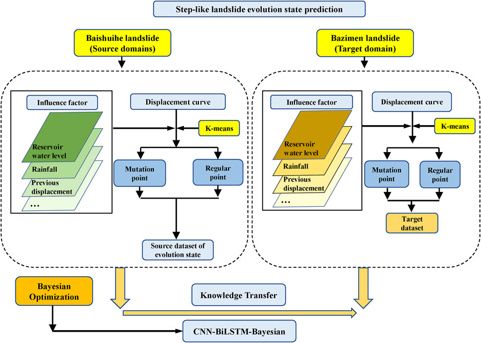
Figure 1. The structure of the article.
2 Methodology
2.1 Transfer learning
Transfer learning is a machine learning method that utilizes the knowledge from a model trained on a source task (Ds) and transfers it to a target task (Ts) to improve transferability ability (Wang et al., 2023), as shown in Figure 2. Traditional machine learning or deep learning methods typically train the model from scratch; even if the tasks are similar, the parameters of the existing model cannot be directly reused (Figure 2). For transfer learning, the model trained on the source task is initially employed to extract relevant knowledge for the target task. Subsequently, certain parameters of the model are fine-tuned to align with the specific requirements of the target task. This fine-tuning makes transfer learning more efficient than training a high-performance model from scratch.
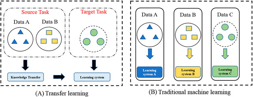
Figure 2. Diagram of transfer learning and traditional machine learning. (A) Transfer learning. (B) Traditional machine learning.
The Baishuihe and Bazimen landslides are both categorized as reservoir drawdown-induced landslides and exhibit similar monitoring characteristics (Zhang et al., 2021). Previous studies have demonstrated that transfer learning can substantially enhance the predictive performance of models for such tasks (Ye and Dai, 2021). Moreover, the target task in a transfer learning framework typically requires only limited monitoring data, thereby reducing both the data demand and the computational cost associated with model training (Wang et al., 2023). In this study, the Baishuihe landslide is used as the source task, and the Bazimen landslide is taken as the target task (Figure 3).
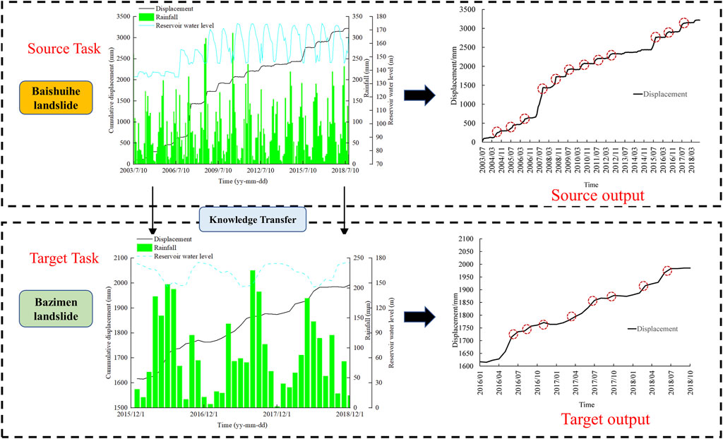
Figure 3. Transfer learning model of the Baishuihe and Bazimen landslides.
2.2 CNN-BiLSTM
CNN is designed for processing images and time-series data. It can improve computational efficiency by sharing local receptive fields and parameters (Zai et al., 2024). Because landslide displacement is related to reservoir water level and rainfall, CNN can capture features of waveform sequences by utilizing local receptive fields and weight sharing.
The LSTM network has three gates that control the flow of information, helping manage long-term information and preventing gradient vanishing problems (Zai et al., 2024). These gates are the forget gate (
Where
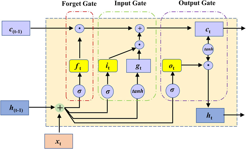
Figure 4. The components of the LSTM unit.
BiLSTM is composed of two independent LSTM networks, which are respectively responsible for processing the input sequence from two directions (forward and backward). Therefore, a BiLSTM model can obtain information before and after the current time step simultaneously (Huang et al., 2020). Incorporating attention mechanisms into wave-based networks further enhances such temporal modeling capabilities (Moreh et al., 2024).
BiLSTM can effectively capture the forward and backward dependencies of the displacement sequence by running two independent LSTM networks on the sequence data in parallel (Figure 5).
Where
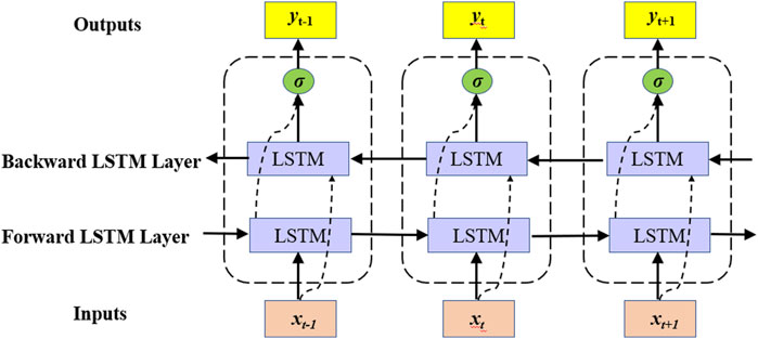
Figure 5. The BiLSTM workflow.
Therefore, a CNN-BiLSTM model can capture both the time-series features of the displacement curve and associated influencing factors, making it suitable for predicting the evolutionary stage of step-like landslides. Lattice-based simulations have also been used to model cemented geomaterials under evolving stress paths (Rizvi et al., 2020).
2.3 Bayesian optimization
The model’s hyperparameters significantly influence its accuracy (Li et al., 2021). However, grid search (GS) and random search (RS) require time resources and are inefficient (Xia et al., 2017). The Bayesian method is a global optimization technique designed to efficiently optimize machine learning models (Abbas et al., 2023). At each iteration, a surrogate model of the objective function is constructed based on all current evaluation results, and an acquisition function is employed to determine the next optimal sampling point. Therefore, the Bayesian optimization consists of two core components: a surrogate model that approximates the objective function and an acquisition function that determines the sampling strategy. The surrogate model serves as an approximation of the objective function, addressing the parameter optimization problem by constructing a stochastic mapping from the input parameter space to the corresponding objective function values. The acquisition function mathematically balances exploration and exploitation by assessing the potential optimization value of unexplored points (Abbas et al., 2023; Bischl et al., 2023). Gaussian processes (GPs) are used to model the probability of the objective function and search for the optimal solution efficiently, as seen in Figure 6. The expected improvement (EI) is utilized as the acquisition function due to its effectiveness in balancing exploration and exploitation (Xia et al., 2017).
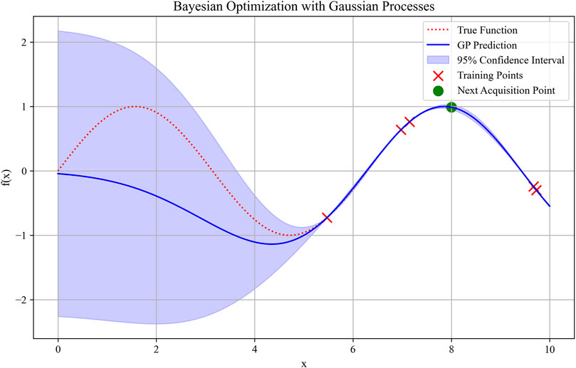
Figure 6. Gaussian processes for samples.
Table 1 presents the complete framework of the Bayesian optimization algorithm. Obj(x) presents the objective function, S is the data points, Ac is the acquisition function, N represents the number of cycles, and Sf presents the surrogate function.
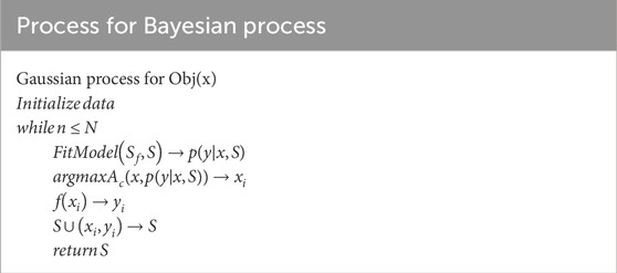
Table 1. The process of Bayesian optimization.
The optimal hyperparameters of the CNN-BiLSTM architecture can be determined through Bayesian optimization, which is conceptually similar to damping calibration in dynamic fluid modeling (Haroon et al., 2017). The complete Bayesian optimization framework is thoroughly described by Abbas et al. (2023). Both soft and hard computation strategies have been validated in predicting thermal performance of geomaterials, providing a useful framework for coupled models (Rizvi et al., 2020).
2.4 K-means cluster
K-means clustering is a distance-based machine learning model that partitions data into k distinct clusters. The basic principle is to maximize the similarity of data points of the same type while increasing the differences between data points of different categories (Gan and Ng, 2017), as shown in Figure 7. In this article, identifying mutation points and stationary points proves challenging. As a result, this study employs K-means clustering to effectively classify mutation points and stationary points. Previous work on lattice element methods for thermal conductivity mapping supports the classification potential of fine-resolution geodata (Rizvi et al., 2018).
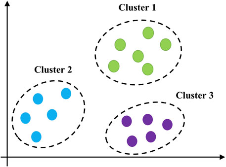
Figure 7. K-means clustering diagram.
2.5 Evaluation methods
2.5.1 Confusion matrix
Correct classifications are the true negative (TN) and true positive (TP), while misclassifications are either false positive (FP) or false negative (FN).
2.5.2 F1-score
The F1-score is composed of precision (P) and recall (R), the relevant formulas are shown in Equations 9–11.
2.5.3 ROC and AUC
The receiver operating characteristic (ROC) curve is used to evaluate the accuracy of the prediction model by the true positive rate (TPR) and the false positive rate (FPR). The relevant formulas are listed in Equations 12, 13, respectively. The area under the curve (AUC) is the area beneath the ROC curve.
Neural network models have also been applied to estimate thermal conductivity from indirect soil parameters (Rizvi et al., 2022).
3 Case study
3.1 Baishuihe landslide
The Baishuihe landslide is located in Hubei Province (coordinates: N 110°32′09″, E 31°01′34″). The location of the landslide is depicted in Figure 8. The primary slope of the landslide is approximately 20°–30°. The landslide volume is 1.26 × 10⁷ m3 with an average thickness of approximately 30 m. The Baishuihe landslide is approximately 500 m long and 430 m wide. The monitoring point plan of the Baishuihe landslide is shown in Figure 9.
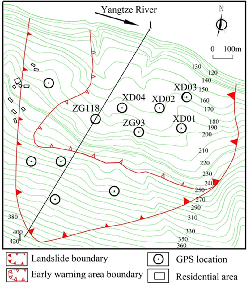
Figure 8. Location of landslide research area.
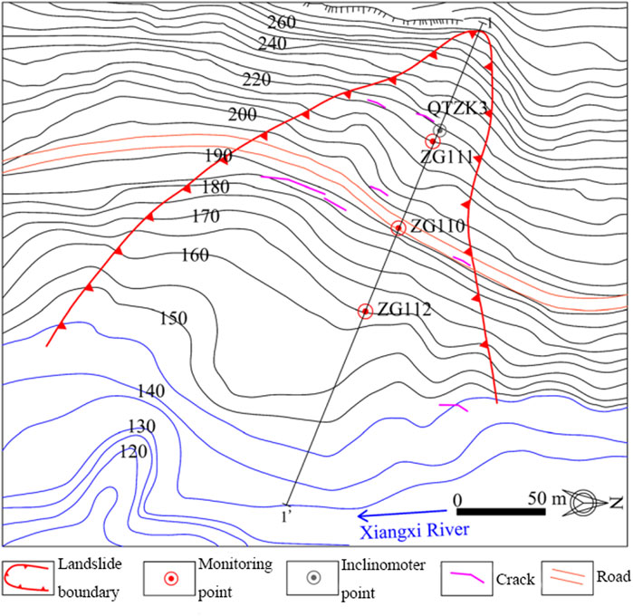
Figure 9. Layout of monitoring points for the Baishuihe landslide.
3.2 Bazimen landslide
The Bazimen landslide is situated in Hubei Province within the TGRA. The landslide elevation is between 65 m and 280 m. The slope of the landslide is approximately 20°–30°, and the volume is approximately 2.35 × 10⁶ m3. The total area of the Bazimen landslide is approximately 1.18 × 10⁵ m2, and the thickness is approximately 10–50 m. The landslide location is shown in Figure 8. The monitoring point plan of the Bazimen landslide is shown in Figure 10.
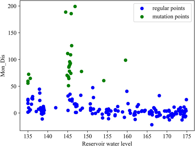
Figure 10. Monitoring point plan of the Bazimen landslide.
3.3 Analysis of the monitoring data
The landslide body is equipped with multiple high-precision global navigation satellite system (GNSS) monitoring stations, capable of capturing real-time displacement variations. Each device records data at intervals ranging from several minutes to a few hours. The raw monitoring data undergo a series of preprocessing steps, including outlier elimination, interpolation of missing values, and standardization of time formats.
Based on data completeness, the ZG118 monitoring data of the Baishuihe landslide and the ZG110 monitoring data of the Bazimen landslide are chosen. For the source domain (Baishuihe landslide), the monthly displacement (mon_dis), monthly rainfall, and reservoir water level from August 2003 to October 2018 were taken as the training data. For the target domain (Bazimen landslide), the monitoring data from February 2016 to December 2018 were selected as the test data. The statistical information of landslides is listed in Table 2. A total of 75% of the displacement points of the Baishuihe landslide are less than 17.06 mm, and the average monthly displacement of the Baishuihe landslide is greater than that of the Bazimen landslide. At the same time, because the displacement monitoring time of the landslides is different, the changes in reservoir water levels are also different.
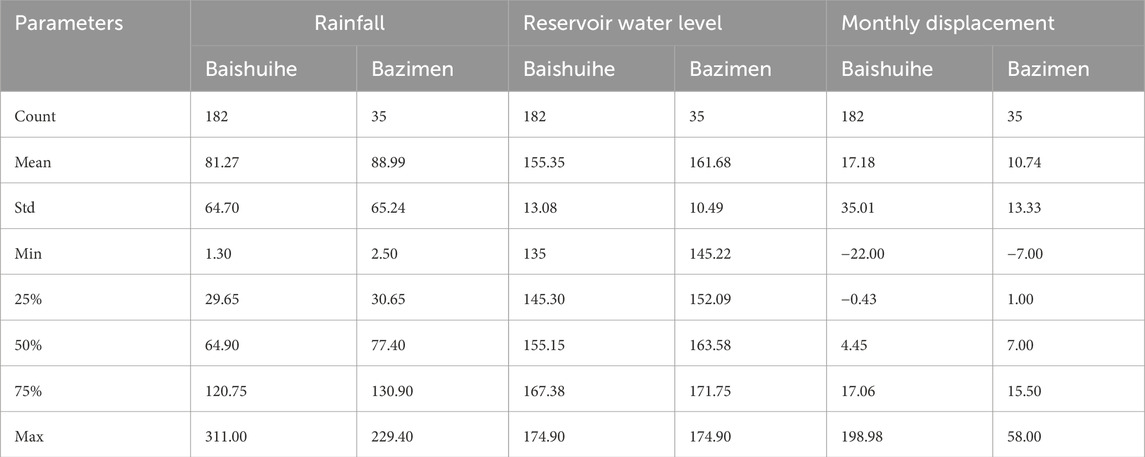
Table 2. Landslide statistical information.
Figure 11 shows the relationship between rainfall, reservoir water level, and monthly displacement. The rainfall of the Baishuihe landslide (Figure 11A) is mainly concentrated between 0 mm and 100 mm, and when the rainfall is approximately 0–50 mm, the monthly displacement within this rainfall range is between 5 mm and 20 mm. Additionally, the monthly displacement gradually increases with the increase in rainfall. The monthly displacement corresponding to the high reservoir water level is generally lower than that corresponding to the low reservoir water level. The reservoir water level primarily ranges between 145–175 m and 165–175 m. When the reservoir water level is 145 m, the corresponding monthly displacement is significantly greater than the monthly displacements corresponding to other reservoir water levels. The rainfall of the Bazimen landslide (Figure 11B) is mainly concentrated between 0 mm and 90 mm, and the monthly displacement gradually increases with the increase of rainfall. When the reservoir water level is between 145 m and 150 m, the monthly displacement is large.
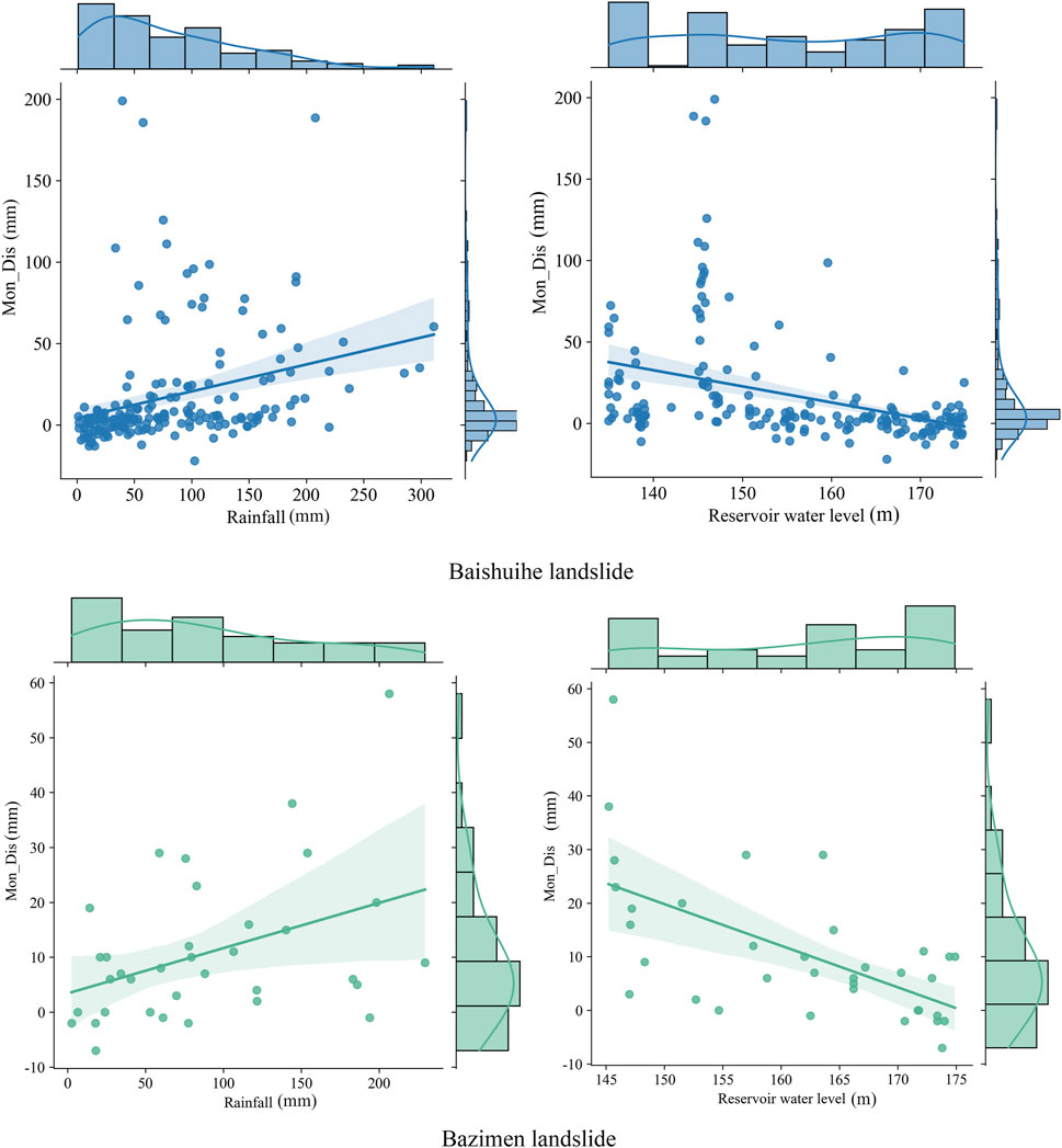
Figure 11. Rainfall, reservoir water level, and monthly displacement of (A) (Baishuihe landslide) and (B) (Bazimen landslide).
The analysis indicates that a strong correlation exists between the evolutionary stage of landslides and the decrease in the water level and rainfall, which aligns with findings in thermal backfill environments showing cyclic thermal influence on ground deformation (Ahmad et al., 2019). During the rapid drawdown of the reservoir water level, the decline in the groundwater level within the landslide body lags behind the decline of the reservoir water level, resulting in a seepage force directed outward from the slope. This significantly decreased the stability of the landslide. The coupling effect between hydrodynamic pressure and sliding force becomes more pronounced, similar to cyclic heating responses in subsurface materials (Ahmad et al., 2021). When rainfall coincides with the reservoir water level decline, step-like landslide deformation increases significantly. Therefore, the Baishuihe and Bazimen landslides belong to the type of reservoir water drop landslides.
The classification results of mutation and regular points are presented in Figure 12. Figure 12 shows that points with a monthly displacement of more than 50 mm are classified as mutation points, while points with a monthly displacement of less than 50 mm are classified as regular points. Unlike previous studies, this study established a clear criterion for classifying evolutionary state points.
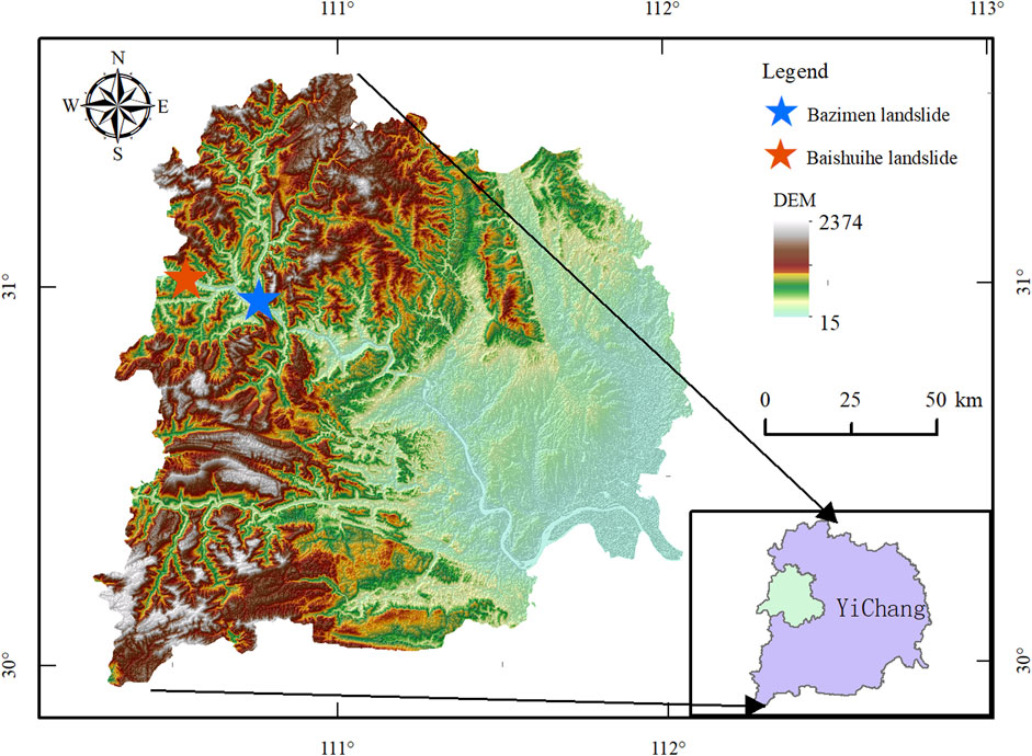
Figure 12. Classification for mutation points and regular points.
4 Results
4.1 Confusion matrix results
This article uses a variety of models to carry out comparative tests, including CNN-BiLSTM, GRU (Zhang et al., 2022), and BiLSTM. The parameter of the models is determined by integrating theoretical foundations, task-specific requirements, empirical heuristics, and computational resources (Wang et al., 2022; Zai et al., 2024). Table 3 lists the commonly used parameter ranges during the optimization process (Xia et al., 2017; Bischl et al., 2023). The main parameters of the proposed model are summarized in Table 4.
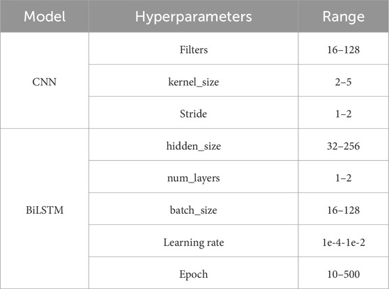
Table 3. The range of hyperparameters.

Table 4. The main parameters of the proposed model.
In the confusion matrix, label 0 represents regular points, and label 1 represents mutation points. Figures 13, 14 show the confusion matrices of different methods for the Baishuihe and Bazimen landslides, respectively. The matrix values in the CNN-BiLSTM-Bayesian model are better than those of the others. The performance of the confusion matrix is ranked as follows: CNN-BiLSTM-Bayesian, CNN-BiLSTM, BiLSTM, and GRU. After transfer learning and parameter tuning, the confusion matrix of the proposed model increased by 1.20% and 16.28%, respectively.
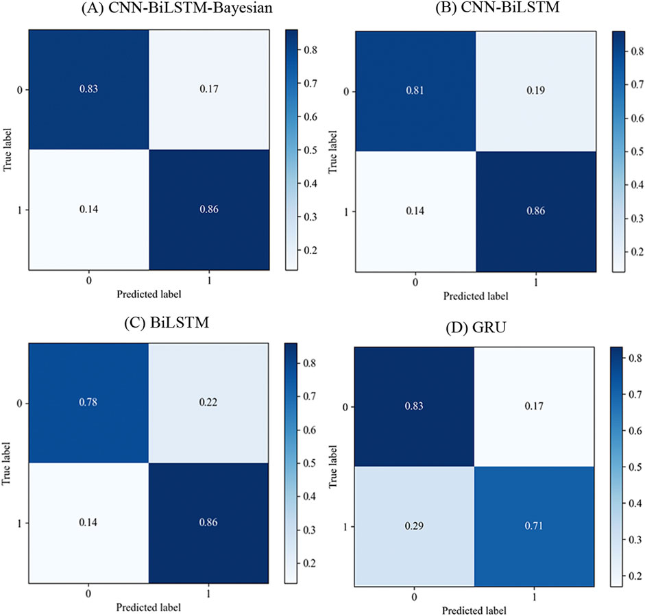
Figure 13. Confusion matrix of models for the Baishuihe landslide: (A) CNN-BiLSTM-Bayesian; (B) CNN-BiLSTM; (C) BiLSTM; (D) GRU.
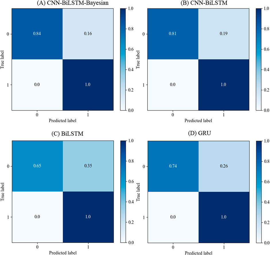
Figure 14. Confusion matrix of models for the Bazimen landslide: (A) CNN-BiLSTM-Bayesian; (B) CNN-BiLSTM; (C) BiLSTM; (D) GRU.
4.2 F1-score
The evaluation indexes for different landslides are shown in Figure 15. The CNN-BiLSTM-Bayesian model achieves the best performance on every evaluation metric, followed by CNN-BiLSTM, BiLSTM, and GRU. The precision, recall, and F1-score of the CNN-BiLSTM-Bayesian model for the Bashuihe landslide are 0.89, 0.84, and 0.85, respectively. For the Bazimen landslide, the indexes of the proposed model are 0.97, 0.84, and 0.89, respectively. After transfer learning and parameter tuning, the F1-score of the proposed model increased by 4.71%.
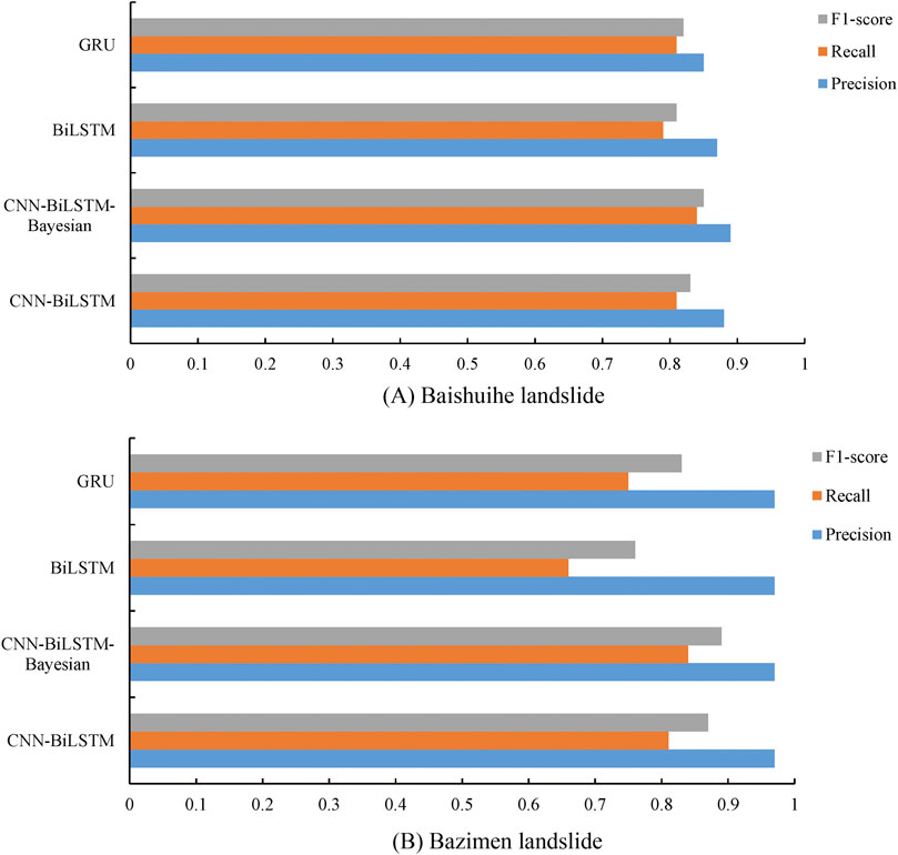
Figure 15. Evaluation indicators for (A) the Baishuihe landslide and (B) the Bazimen landslide.
F1-scores of models for the Baishuihe and Bazimen landslides are summarized in Table 5. The CNN-BiLSTM-Bayesian model achieved the best F1-scores (0.85 and 0.89), followed by CNN-BiLSTM (0.83 and 0.87), and GRU (0.82 and 0.83). Compared with BiLSTM, the F1-score of the CNN-BiLSTM-Bayesian model improved by 4.94% for the Baishuihe landslide, which means the Bayesian optimization and CNN layer can improve the F1-score. Therefore, the CNN-BiLSTM-Bayesian model is suitable for predicting the evolutionary stage of landslides.
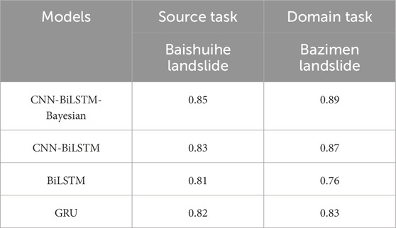
Table 5. F1-scores of the Baishuihe and Bazimen landslides.
4.3 ROC and AUC
The ROC curve and AUC values of the models for the Baishuihe landslide are shown in Figure 16. The CNN-BiLSTM-Bayesian model achieved the highest AUC score across all classes, indicating its superior capability in predicting the evolution state. Compared with BiLSTM, the AUC score of the CNN-BiLSTM-Bayesian model improved by 4.88% for the Baishuihe landslide, which means the Bayesian optimization and CNN layer can improve model accuracy. The CNN-BiLSTM and GRU models were inferior compared to the proposed model.
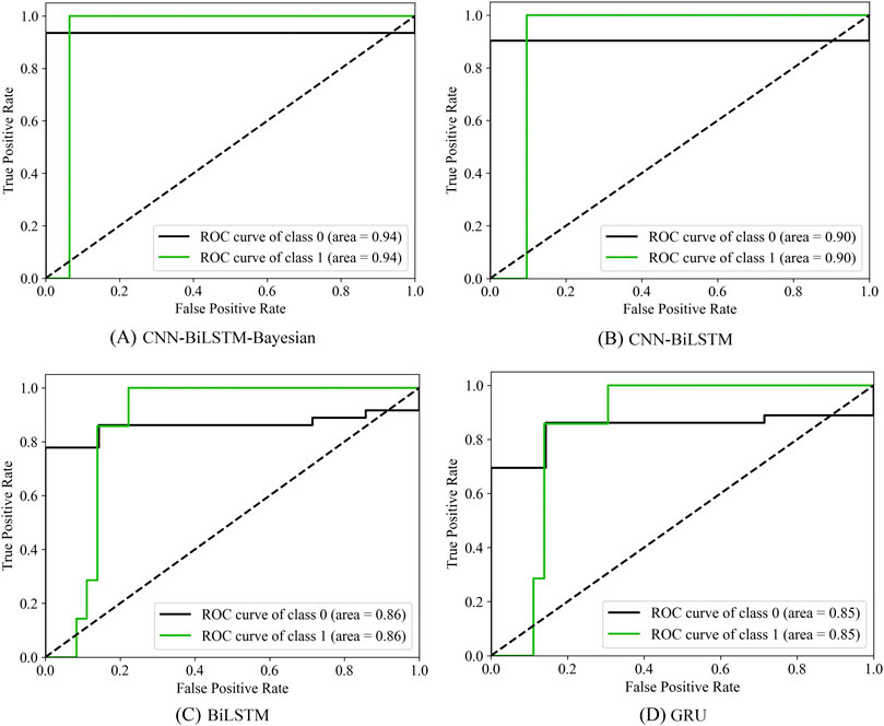
Figure 16. ROC and AUC of models for the Baishuihe landslide: (A) CNN-BiLSTM-Bayesian; (B) CNN-BiLSTM; (C) BiLSTM; (D) GRU.
Figure 17 represents the ROC and AUC of different methods for the Bazimen landslide. Compared with the model of the Baishuihe landslide, the AUC score of the CNN-BiLSTM-Bayesian model increased by 9.30%, which means that transfer learning can improve the accuracy.
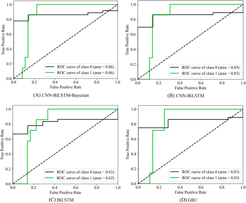
Figure 17. ROC and AUC of models for the Bazimen landslide: (A) CNN-BiLSTM-Bayesian; (B) CNN-BiLSTM; (C) BiLSTM; (D) GRU.
5 Discussion
Understanding landslide evolution is crucial for preventing step-like landslide disasters. Recently, artificial intelligence methods have been applied to landslide research (Zhang et al., 2022). However, there are few studies on predicting the evolution state of landslides in the TGRA. Moreover, it is difficult to transfer knowledge from one landslide to another using traditional machine learning models.
This study proposed a CNN-BiLSTM-Bayesian model to predict the evolutionary stage of step-like landslides. The Bayesian method was applied to search for model parameters. Additionally, transfer learning was employed to ensure prediction accuracy in cases of discontinuous and limited data.
Ge et al. (2022) proposed a density-based clustering model (DBSCAN) to identify the evolution state. The F1-score of the model is 0.8, while the F1-score of our model is 0.89. The CNN-BiLSTM-Bayesian model shows an improvement of 11.25% compared with DBSCAN. In contrast to the research by Lian et al. (2018), this research takes rainfall and reservoir water level as input, both of which significantly influence the evolutionary stage.
For the Bazimen landslide, the F1-score and AUC of the CNN-BiLSTM-Bayesian model are 0.87 and 0.94, respectively, which are 4.71% and 9.30% higher than those of the Baishuihe landslide. Based on evaluation metrics, the CNN-BiLSTM-Bayesian model outperforms other models, demonstrating the excellent performance of the proposed model. CNN focuses on short-term local features, while BiLSTM focuses on long-term dependencies. The combination of the structures can more fully explore the temporal features in the data and improve classification performance. Bayesian optimization is highly effective in adjusting model parameters and enhancing accuracy. The deep transfer learning model proposed in this article has better accuracy and generalization ability on new data.
However, this study has some limitations. The CNN-BiLSTM-Bayesian model and the proposed classification criteria are only applicable to step-like landslides in the reservoir area, and the accuracy can be further improved by combining data from various types of landslides.
6 Conclusion
This study developed a deep transfer learning model based on Bayesian optimization to predict the evolutionary stage of step-like landslides. The proposed model was trained and learned from the Baishuihe landslide, and the predictive performance for the evolutionary stage was verified using the Bazimen landslide. Additionally, the Bayesian method is applied to optimize the hyperparameters of the CNN-BiLSTM model. The conclusions are as follows:
1) For the target task, the F1-score and AUC of the CNN-BiLSTM-Bayesian model are 0.89 and 0.94, followed by CNN-BiLSTM, GRU, and BiLSTM. The predictive performance of the CNN-BiLSTM-Bayesian model is superior to that of other models.
2) A classification rule for the evolution state of step-like landslides has been established. According to this standard, points with monthly displacement exceeding 50 mm are classified as mutation points, while those with displacement less than 50 mm are regular points.
3) Compared with BiLSTM, the F1-score and AUC of the CNN-BiLSTM-Bayesian model improved by 4.94% and 4.89% for the Baishuihe landslide, which means the Bayesian optimization and CNN layer can improve the accuracy of models.
4) Compared to other models, the CNN-BiLSTM-Bayesian model can accurately predict the evolutionary stage. The proposed transfer learning method facilitates the sharing of knowledge across similar landslides and has been proven to be an intelligent and promising approach.
Data availability statement
The datasets presented in this study can be found in online repositories. The names of the repository/repositories and accession number(s) can be found below: The data presented in this study are available on request from the National Cryosphere Desert Data Center (https://www.ncdc.ac.cn/portal/).
Author contributions
TM: Writing – original draft, Writing – review and editing, Funding acquisition, Methodology, and Conceptualization. HX: Methodology, Writing – review and editing, and Supervision. YY: Writing – review and editing, Supervision, and Validation.
Funding
The author(s) declare that financial support was received for the research and/or publication of this article. We thank the Chengdu University of Technology Postgraduate Innovative Cultivation Program (No. CDUT2023BJCX006).
Acknowledgments
We gratefully acknowledge the National Cryosphere Desert Data Center (https://www.ncdc.ac.cn/portal/) for providing the research data utilized in this study.
Conflict of interest
The authors declare that the research was conducted in the absence of any commercial or financial relationships that could be construed as a potential conflict of interest.
Generative AI statement
The author(s) declare that no Generative AI was used in the creation of this manuscript.
Publisher’s note
All claims expressed in this article are solely those of the authors and do not necessarily represent those of their affiliated organizations, or those of the publisher, the editors and the reviewers. Any product that may be evaluated in this article, or claim that may be made by its manufacturer, is not guaranteed or endorsed by the publisher.
References
Abbas, F., Zhang, F., Ismail, M., Khan, G., Iqbal, J., Alrefaei, A. F., et al. (2023). Optimizing machine learning algorithms for landslide susceptibility mapping along the Karakoram highway, Gilgit Baltistan, Pakistan: a comparative study of baseline, bayesian, and metaheuristic hyperparameter optimization techniques. Sensors 23 (15), 6843. doi:10.3390/s23156843
Ahmad, S., Rizvi, Z., Khan, M. A., Ahmad, J., and Wuttke, F. (2019). Experimental study of thermal performance of the backfill material around underground power cable under steady and cyclic thermal loading. Mater. Today Proc. 17 (1), 85–95. doi:10.1016/j.matpr.2019.06.404
Ahmad, S., Rizvi, Z., and Wuttke, F. (2025). Unveiling soil thermal behavior under ultra-high voltage power cable operations. Sci. Rep. 15, 7315. doi:10.1038/s41598-025-91831-1
Ahmad, S., Rizvi, Z. H., Arp, J. C. C., Wuttke, F., Tirth, V., and Islam, S. (2021). Evolution of temperature field around underground power cable for static and cyclic heating. Energies 14 (23), 8191. doi:10.3390/en14238191
Alsabhan, A. H., Sadique, M. R., Ahmad, S., Alam, S., and Binyahya, A. S. (2021). The effect of opening shapes on the stability of underground tunnels: a finite element analysis. Int. J. Geomate 21 (87), 19–27. doi:10.21660/2021.87.j2267
Bischl, B., Binder, M., Lang, M., Pielok, T., Richter, J., Coors, S., et al. (2023). Hyperparameter optimization: foundations, algorithms, best practices, and open challenges. Wiley Interdiscip. Rev. Data Min. Knowl. Discov. 13 (2), e1484. doi:10.1002/widm.1484
Fan, X., Scaringi, G., Xu, Q., Zhan, W., Dai, L., Li, Y., et al. (2018). Coseismic landslides triggered by the 8th August 2017 M s 7.0 Jiuzhaigou earthquake (Sichuan, China): factors controlling their spatial distribution and implications for the seismogenic blind fault identification. Landslides 15 (5), 967–983. doi:10.1007/s10346-018-0960-x
Gan, G., and Ng, M. K. P. (2017). k-means clustering with outlier removal. Pattern Recognit. Lett. 90, 8–14. doi:10.1016/j.patrec.2017.03.008
Ge, Q., Sun, H., Liu, Z., Yang, B., Lacasse, S., and Nadim, F. (2022). A novel approach for displacement interval forecasting of landslides with step-like displacement pattern. Georisk 16 (3), 489–503. doi:10.1080/17499518.2021.1892769
Gong, W., Tian, S., Wang, L., Li, Z., Tang, H., Li, T., et al. (2022). Interval prediction of landslide displacement with dual-output least squares support vector machine and particle swarm optimization algorithms. Acta Geotech. 17 (9), 4013–4031. doi:10.1007/s11440-022-01455-2
Haroon, A., Ahmad, S., and Hussain, A. (2017). “CFD prediction of loss coefficient in straight pipes,” in Development of water resources in India. Water science and technology Library. Editors V. Garg, V. Singh, and V. Raj (Cham: Springer). doi:10.1007/978-3-319-55125-8_41
Huang, F., Zhang, J., Zhou, C., Wang, Y., Huang, J., and Zhu, L. (2020). A deep learning algorithm using a fully connected sparse autoencoder neural network for landslide susceptibility prediction. Landslides 17 (1), 217–229. doi:10.1007/s10346-019-01274-9
Kavzoglu, T., and Teke, A. (2022). Advanced hyperparameter optimization for improved spatial prediction of shallow landslides using extreme gradient boosting (XGBoost). Bull. Eng. Geol. Environ. 80 (5), 201. doi:10.1007/s10064-022-02708-w
Li, L., Wu, Y., Miao, F., Xue, Y., and Huang, Y. (2021). A hybrid interval displacement forecasting model for reservoir colluvial landslides with step-like deformation characteristics considering dynamic switching of deformation states. Stoch. Environ. Res. Risk Assess. 35 (6), 1089–1112. doi:10.1007/s00477-020-01914-w
Lian, C., Zhu, L., Zeng, Z., Su, Y., Yao, W., and Tang, H. (2018). Constructing prediction intervals for landslide displacement using bootstrapping random vector functional link networks selective ensemble with neural networks switched. Neurocomputing 291, 1–10. doi:10.1016/j.neucom.2018.02.046
Ma, J., Xia, D., Guo, H., Wang, Y., Niu, X., Liu, Z., et al. (2022). Metaheuristic-based support vector regression for landslide displacement prediction: a comparative study. Landslides 19 (10), 2489–2511. doi:10.1007/s10346-022-01923-6
Moreh, H., Hasan, Y., Rizvi, Z. H., Wuttke, F., and Tomforde, S. (2024). “Wave-based neural network with attention mechanism for damage localization in materials,” in International conference on machine learning and applications (ICMLA). Miami, FL, 122–129. doi:10.1109/ICMLA61862.2024.00023
Muhammad, M., Williams-Jones, G., Stead, D., Tortini, R., Falorni, G., and Donati, D. (2022). Applications of image-based computer vision for remote surveillance of slope instability. Front. Earth Sci. 10, 909078. doi:10.3389/feart.2022.909078
Qiao, J., Zhang, Y., Li, W., and Tan, J. (2023). IPSO-ELM intelligent prediction of landslide displacement in complex and unstable area of karst landform. Front. Earth Sci. 11, 1222920. doi:10.3389/feart.2023.1222920
Rizvi, Z. H., Akhtar, S. J., Husain, S. M. B., Khan, M., Haider, H., Naqvi, S., et al. (2022). Neural network approaches for computation of soil thermal conductivity. Mathematics 10 (21), 3957. doi:10.3390/math10213957
Rizvi, Z. H., Mustafa, S. H., Sattari, A. S., Ahmad, S., Furtner, P., and Wuttke, F. (2020). “Dynamic lattice element modelling of cemented geomaterials,” in Advances in computer methods and geomechanics. Lecture notes in civil engineering (Singapore: Springer). doi:10.1007/978-981-15-0886-8_53
Rizvi, Z. H., Shrestha, D., Sattari, A. S., and Wuttke, F. (2018). Numerical modelling of effective thermal conductivity for modified geomaterial using lattice element method. Heat. Mass Transf. 54 (2), 483–499. doi:10.1007/s00231-017-2140-2
Rizvi, Z. H., Zaidi, H. H., Akhtar, S. J., Sattari, A. S., and Wuttke, F. (2020). Soft and hard computation methods for estimation of the effective thermal conductivity of sands. Heat. Mass Transf. 56 (6), 1947–1959. doi:10.1007/s00231-020-02833-w
Sun, S., Wang, X., Li, J., and Lian, C. (2022). Landslide evolution state prediction and down-level control based on multi-task learning. Knowledge-Based Syst. 238, 107884. doi:10.1016/j.knosys.2021.107884
Wang, H., Wang, L., and Zhang, L. (2023). Transfer learning improves landslide susceptibility assessment. Gondwana Res. 123, 238–254. doi:10.1016/j.gr.2022.07.008
Wang, J., Xiang, W., and Lu, N. (2014). Landsliding triggered by reservoir operation: a general conceptual model with a case study at three Gorges Reservoir. Acta Geotech. 9 (5), 771–788. doi:10.1007/s11440-014-0315-2
Wang, R., Zhang, K., Qi, J., Xu, W., Long, Y., and Huang, H. (2022). A prediction model of hydrodynamic landslide evolution process based on deep learning supported by monitoring big data. Front. Earth Sci. 10, 829221. doi:10.3389/feart.2022.829221
Wang, Y., Tang, H., Huang, J., Wen, T., Ma, J., and Zhang, J. (2022). A comparative study of different machine learning methods for reservoir landslide displacement prediction. Eng. Geol. 298, 106544. doi:10.1016/j.enggeo.2022.106544
Wu, L. Z., Zhao, D. J., Zhu, J. D., Peng, J. B., and Zhou, Y. (2020). A late Pleistocene river-damming landslide, Minjiang River, China. Landslides 17 (2), 433–444. doi:10.1007/s10346-019-01305-5
Xia, Y., Liu, C., Li, Y. Y., and Liu, N. (2017). A boosted decision tree approach using Bayesian hyper-parameter optimization for credit scoring. Expert Syst. Appl. 78, 225–241. doi:10.1016/j.eswa.2017.02.017
Yang, W., Feng, Y., Wan, J., and Wang, L. (2022). Sparse gaussian process regression for landslide displacement time-series forecasting. Front. Earth Sci. 11, 1222920. doi:10.3389/feart.2022.944301
Ye, R., and Dai, Q. (2021). Implementing transfer learning across different datasets for time series forecasting. Pattern Recognit. 109, 107617. doi:10.1016/j.patcog.2020.107617
Zai, D., Pang, R., Xu, B., and Liu, J. (2024). A novel data-driven hybrid intelligent prediction model for reservoir landslide displacement. Bull. Eng. Geol. Environ. 83, 493. doi:10.1007/s10064-024-03987-1
Zhang, K., Zhang, K., Cai, C., Liu, W., and Xie, J. (2021). Displacement prediction of step-like landslides based on feature optimization and VMD-Bi-LSTM: a case study of the Bazimen and Baishuihe landslides in the Three Gorges, China. Bull. Eng. Geol. Environ. 80 (11), 8481–8502. doi:10.1007/s10064-021-02454-5
Zhang, W., Li, H., Tang, L., Gu, X., Wang, L., and Wang, L. (2022). Displacement prediction of Jiuxianping landslide using gated recurrent unit (GRU) networks. Acta Geotech. 17 (4), 1367–1382. doi:10.1007/s11440-022-01495-8
Keywords: landslide evolutionary stage, CNN-BiLSTM-Bayesian, transfer learning, landslide earning early warning, step-like landslides
Citation: Ma T, Xiao H and Yang Y (2025) Deep transfer learning with Bayesian optimization for evolutionary-stage prediction of step-like landslides. Front. Earth Sci. 13:1634728. doi: 10.3389/feart.2025.1634728
Received: 25 May 2025; Accepted: 17 July 2025;
Published: 29 August 2025.
Edited by:
Wen Nie, Jiangxi University of Science and Technology, ChinaReviewed by:
Zarghaam Rizvi, GeoAnalysis Engineering GmbH, GermanyWenmin Yao, Zhengzhou University, China
Copyright © 2025 Ma, Xiao and Yang. This is an open-access article distributed under the terms of the Creative Commons Attribution License (CC BY). The use, distribution or reproduction in other forums is permitted, provided the original author(s) and the copyright owner(s) are credited and that the original publication in this journal is cited, in accordance with accepted academic practice. No use, distribution or reproduction is permitted which does not comply with these terms.
*Correspondence: Tao Ma, b3BtYXRhb0AxNjMuY29t