 Zhansheng Chen1,2†
 Xue Chen
- 1Center for Geophysical Survey, China Geological Survey, Langfang, Hebei, China
- 2Technology Innovation Center for Earth Near Surface Detection, China Geological Survey, Langfang, Hebei, China
Background: The study of the formation and evolution of black soils holds significant implications for the sustainable utilization of black soil resources and human societal development. However, research exploring the regularity of black soil formation and evolution through surface substrate investigations remains limited.
Method: This paper, based on the novel concept of “surface substrate layer” proposed by China’s Ministry of Natural Resources, takes the black soils in Fengcheng City and Kuandian County of Dandong City, Liaoning Province, China as the research object.
Objective: Through integrated analysis of surface substrate classification and geochemical element characterization, this study systematically elucidates the multidimensional controlling mechanisms of parent rock properties on black soil pedogenesis for the first time.
Results: The results demonstrate pronounced differences in soil characteristics developed from various parent materials. In terms of physical properties: soils formed by the weathering of sedimentary rocks (e.g., carbonate rocks) exhibit finer particle sizes, while soils derived from older metamorphic rocks (e.g., TTG gneiss) have the coarsest particle sizes; soil pH is primarily influenced by parent rock mineral composition, with basic rocks (e.g., basalt) developing acidic soils whereas marble forms neutral soils; soil bulk density correlates with the compactness of parent rocks, with soils developed from Cenozoic basalt exhibiting the highest bulk density. Regarding geochemical characteristics: principal component analysis clearly distinguishes soils developed from different parent rock types, demonstrating their elemental composition inheritance from parent rocks. Chemical index of alteration (CIA) and silica-alumina ratio (Sa) analyses reveal that basic rocks (e.g., Cenozoic basalt) undergo the highest degree of weathering, while metamorphic rocks such as TTG gneiss exhibit the greatest weathering resistance. Beneficial trace elements (e.g., Se, N, P) are generally enriched, but their enrichment levels are closely related to parent rock types. Therefore, lithology of parent rocks serves as the key factor controlling the formation and differentiation of surface substrate properties in the study area’s black soil.
Conclusions: This understanding holds significant scientific importance for deepening the comprehension of black soil formation and evolution patterns, as well as for implementing precise conservation measures and soil quality improvement based on surface substrate investigation backgrounds.
1 Introduction
In 2020, the Ministry of Natural Resources of China issued the General Plan for the Construction of Natural Resources Investigation and Monitoring System (Ministry of Natural Resources, 2020), which establishes a unified natural resources investigation business system in the new era, including ground substrate layer, ground cover layer, underground resource layer and management element layer. It is of great significance to improve the natural resources supervision system, organize the implementation of natural resources investigation and monitoring, and support the Ministry of Natural Resources to serve the “two unified” functions of natural resources. The Plan introduces the “ ground substrate layer” for the first time in the hierarchical classification model of natural resources, and it is clear that the ground substrate surveys should be carried out. The Plan defines the ground substrate as the basic material layer of the earth’s surface that breeds and supports various natural resources such as forests, grasslands, water and wetlands. It clarifies the basic and natural properties of the ground substrate, which is the basis for the existence of various natural resources of “mountains, rivers, forests, fields, lakes, grasses and sand”. As the connecting layer between the underground resource layer and the ground cover layer, the ground substrate layer is a complex and open system composed of the interaction of hydrosphere, soil sphere, atmosphere, lithosphere, biosphere and anthroposphere (Song et al., 2020). It is the main carrier of the earth’s surface ecosystem, and the most dynamic level of human activities and material exchange. Although the ground substrate layer was first proposed as a layer of natural resources, it is not a new concept. Previous researches in Earth system science and natural resource disciplines have touched upon related topics, such as bedrock, weathering crust, quaternary sediments and loose deposits in geology;: groundwater table depth and storage in hydrology; soil parent material, restrictive layers and soil horizons in agronomy; site conditions in forestry/grassland science (Gu et al., 1993). From the perspective of the earth system as a whole, Zhao Songqiao et al. pointed out that “the land system is a synthesis of all natural geographical elements including geology, geomorphology, climate, hydrology, vegetation and soil” (Zhao, 1983). Zhang Ganlin et al. constructed a three-level classification system of the Earth’s key zones (Zhang et al., 2021), including rocks, groundwater, soil and the near-surface atmosphere up to vegetation canopies in the vertical dimension, covering all the Earth’s surface layers.
Following the formalization of the ground substrate layer concept, many scholars have conducted research and exploration around the classification of ground substrate, and initially proposed a three-level classification scheme of ground substrate (Ministry of Natural Resources, 2020). Many units have carried out pilot work of ground substrate investigation, explored and constructed a system of ground substrate investigation elements, indicators and technical methodologies. Scholars analyzed the basic positioning, significance and overall planning design of ground substrate survey (Ge and Yang, 2020), conducted preliminary research on ground substrate classification and survey, and proposed classification principles and schemes (Yin et al., 2020). Hou Hongxing and Lu Min et al. took the lead in carrying out pilot work of ground substrate survey in Baoding area, summarized new ground substrate survey techniques and methodologies, and proposed a systematic scheme for the classification, naming and investigation contents of surface (Lu et al., 2020; Hou et al., 2021). Kong et al. (2021), Qin et al. (2021) and Yang et al. (2024) carried out pilot investigations on black soil ground substrate in Baoqing area of Sanjiang Plain, Lishu area of Liao River Plain and Hailun area of Songnen plain respectively. The contents and index system of ground substrate investigation in black land were summarized, and the technical specifications of ground substrate investigation were improved. Shao Hai explored the investigation and mapping of ground substrate layer in Ruyi River Basin on Chengde Plateau (Shao et al., 2022). While experts hold differing views on the classification of the ground substrate, they fully affirm the critical importance of the ground substrate layer in integrated natural resource management, as well as the essential role and status of conducting ground substrate surveys within the interdisciplinary framework of natural resource sciences and the survey-monitoring systems.
The Law of the People’s Republic of China on the Protection of Black Land defined Black Soil as the cultivated land with black or dark humus topsoil, good properties and high fertility in the relevant areas of Heilongjiang, Jilin, Liaoning and Inner Mongolia Autonomous regions. According to the White paper of Northeast Black land of Chinese Academy of Sciences, black soil refers to the land marked by black or dark humus topsoil layer, which is a kind of high-quality land with good properties, high fertility and suitable for farming (Chinese Academy of Sciences, 2021). It is characterized by a deep dark-water surface layer (>20 cm), good aggregate structure, rich organic matter content (general >15 g/kg), high base saturation (>70%), suitable pH value (5.5–7.0) and suitable surface soil bulk weight (1.0–1.3 g/cm) (Hou et al., 2022). The parent material of the soil is mainly loose sediments such as loess-like clay, diluvium, alluvial, glacial and aeolian sediments. Scholars have studied the relationship between climate and geomorphic evolution and the development of black soil in the typical black soil region of Northeast China (Cui et al., 2008); Hao Xiangxiang et al. conducted a study on the relationship between the blackness of typical black soil and the composition of soil organic matter (Hao et al., 2023); Zhang Xinrong et al. studied the formation and evolution of black soil (Zhang and Jiao, 2020). However, research exploring the regularity of black soil formation and evolution through surface substrate investigations remains limited. There are about 18,667 km2 of typical black soil areas in Liaoning, which are mainly distributed in Liaohe Plain area and eastern low hilly areas, and 17 typical black soil counties (Office of National Leading Group for Soil and Water Conservation Planning, 2016). This study was conducted in two counties of Dandong City, Liaoning Province, China. Through analysis of surface substrate types and geochemical elements, the research systematically revealed the controlling effects of parent rock lithology on soil formation processes, aiming to provide new insights for studies on the formation and evolution of black soil.
2 Research area overview
The research area is located in the foothills of the Liaodong Mountains, a southwestern extension of the Changbai Mountain Range. The terrain gradually decreases from northeast to southwest. According to the topographic features, the northern region of the area is mostly dominated by mid-low mountains with slightly low terrain; The southern region is mostly hilly terrain with significant elevation variations; The southern coastal plains contain flat and gently undulating landscapes. Although the terrain is complex, it is still dominated by mountains and hills, of which 72.4% classified as mountains and hills, 14.6% as plain valleys, 8.7% as water bodies, and only 4.3% as terraces, basins, platforms and other small geomorphic units. The research area includes Fengcheng City and Kuandian Manchu Autonomous County, with a total area of about 11600 km2, both of which are under the jurisdiction of Dandong City.
The research area is located on the east coast of the Eurasia continent, with a temperate continental monsoon climate. Its climate characteristics: concurrent precipitation and warmth, high humidity, distinct seasonal variations, the annual average temperature between 6 and 9 °C, the highest temperature reaches over 30 °C. Monsoon climate is significant, south and north monsoon alternat during the spring and autumn seasons, and the southeast monsoon influences the summer season, bringing abundant rainfall up to 1,100 mm or more. The research area, i.e., Fengcheng City and Kuandian County of Dandong City, Liaoning Province, has natural resources characteristics. First, the low mountain forest is rich in reserves, which is of great significance in safeguarding the national natural ecological security. Second, the cultivated land resources are limited, and the quality of cultivated land is inferior compared to plain area. The third is abundant water resources, due to the characteristics of low mountains and hills, the cultivated land near rivers and valleys has sufficient water resources.
The Quaternary strata belong to the Liaodong stratigraphic division. Since the overall uplift occurred in this area since the Cenozoic era, the third-generation strata and the Pleistocene Mudanhe period strata have been missing. Since the Zhoukoudian period, the sedimentation has mainly been intermittent. Only in the high terrace areas of the river, glacial and volcanic deposits have been preserved. Since the Sarauzu period, a small amount of residual slope deposits have remained in the slopes of residual hills, mountainous basins, river valleys and coastal areas. Various types of deposits such as slope alluvial, flood alluvial, alluvial, lake and marsh deposits, flood sea deposits and marine deposits have developed. The strata of different periods are extremely discontinuous, and mostly presenting erosional parallel unconformities or being separated and not in contact with each other.
3 Materials and methods
3.1 Sample collection
According to the technical procedures for the investigation of ground substrate in black soil, and considering the characteristics of different ground substrate partitions, the encryption was carried out in areas with complex changes in matrix types. The investigation was carried out at a depth of 5 m in the study area using Luoyang shovel and backpack drill, which designed total of 774 sampling points and continuous stratified sampling with each investigation point covering approximately 15 square kilometers (Figure 1). The backpack drill is an SD-1 hand-held hydraulic soil sampling drill. The anti-pollution measures of ground substrate samples in the process of collection and treatment refer to the Code for multi-purpose geochemical survey (DZ/T0258-2014) (Nanjing CenterChina Geological Survey, 2014) and other relevant codes. After soil core extraction, the cataloguing is firstly carried out to determine the sampling location and quantity. Impurities such as gravel and roots should be removed when the soil sample is bagged. The sample is air-dried through a 10-mesh nylon screen and sent to the laboratory in a paper sample bag for analysis.
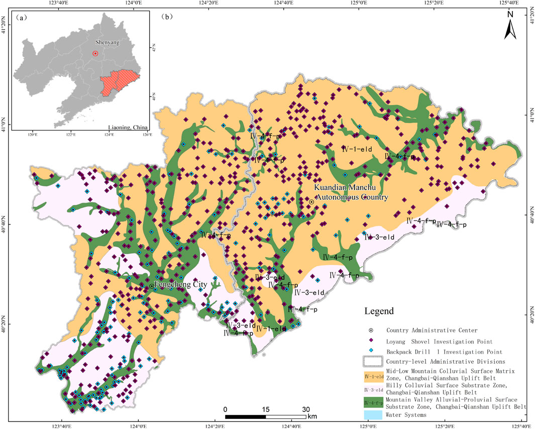
Figure 1. Location map of the research area. (a) Map of Liaoning Province showing the location of the research area (highlighted in red). (b) Surface matrix zoning and drilling point distribution in the research area.
3.2 Analysis test
The sample analysis test was completed by Liaoning Institute of Geology and Mineral Resources Co., LTD. The sample preparation is carried out in strict accordance with the requirements of quality management norms. First, the quality management personnel of the Quality Management Department will determine the batch number of the analysis, and the samples will be extracted as repetitive test samples according to 5% of the total number of samples. The leader of the sample processing group will sign and organize personnel to prepare, process and repackage the samples. The soil samples were pre-dried in a constant-temperature drying oven at 105 °C for 2 hours, and then were placed in a dry container to cool down and be ready for use. The contents of K2O, P, SiO2, Ti, Cl, CaO, TFe2O3, MgO, Mn, and Na2O in the soil samples were measured by the X-ray fluorescence spectrometer (AFS-3100, United States). The levels of Be, CaO, TFe2O3, MgO, Mn, Na2O, Al2O3, Ti, and K2O in the soil samples were determined by the plasma emission spectrometry. Briefly, the 0.20 g detected soil was placed in a 25 mL polytetrafluoroethylene crucible and wet it with water. After being decomposed by hydrofluoric acid and sulfuric acid, above indicators were measured using ICP-OES (iCAP6300, United States); the ICP-MS mass spectrometry was used to measure the contents of Cd and Mo by ICP-MS (X SERIES Ⅱ, Germany); and the levels of Se in those samples were tested by atomic fluorescence analyzer (AFS-3100, Beijing, China). The contents of FeO in the soil samples were detected by volumetric method. In detail, the hydrogen-argon acid and sulfuric acid were added into a platinum crucible with 0.50 g soil sample, and then the potassium dichromate titration was operated to measure. The Kjeldahl method was used to assess the content of N. The 1.00 g of the soil sample was placed in a Kjeldahl flask, followed by the addition of copper sulfate and potassium sulfate. Then, concentrated sulfuric acid was added and the mixture was dissolved on a temperature-controlled electric furnace at 280 °C. The nitrogen content was determined by titration. The REDOX method was selected to calculate the Corg (organic matter) content following the reference of National Environmental Protection Standards of the People’s Republic of China (HJ615-2011). The contents of TC and S in the soil samples were measured by high frequency combustion infrared absorption method using carbon-sulfur element analyzer (CS744, United States). For the assess of pH values, 25 mL of water that has been previously deoxygenated was added to a glass beaker containing 10.0 g of dried samples. Then, placed on a magnetic stirrer to stir for 3 minutes to disperse the samples, and measured the pH values using pH glass electrode (PHS-3G, Shanghai, China). In addition, the ring knife weight method was used to detect the volume weight of the pre-dried soil samples.
The accuracy, precision, reporting rate, and detection limit of the methods all meet the specification requirements. Accuracy control: the 12 soil national first-level standard substances with different contents were selected and evenly inserted into 500 samples. The logarithmic difference between the measured value and the standard value for each element was calculated separately for each analysis result. The accuracy control qualification rate reached over 98%. Precision control: according to the characteristics of the samples in the survey area, 4 national first-level standard substances with background content and high, medium, and low contents were selected as internal quality control samples and inserted into 50 samples in groups, which were analyzed together with the samples. The logarithmic difference and logarithmic standard deviation between the single measurement value and the standard value were calculated to measure the sample analysis precision, reaching over 98%. Reporting rate: different method detection limits were adopted until the reporting rate reached over 99%. The method detection limits all met the normative detection limit requirements.
3.3 Statistical analysis
This study first divided the statistical units based on the type of bedrock at the sampling points. Then, it used mathematical formulas to calculate the data parameters of each unit to quantify their differentiation characteristics. The results were visually presented through charts, and finally, in combination with the regional geological background, the data were comprehensively interpreted to form the research conclusion.
4 Analysis results discussion
From northwest to southeast, the elevation of the research area gradually decreases. The primary zone is classified within the ground substrate area of Changbai Mountain-Qianshan uplift belt (Fushun-Dandong), including 3 secondary zones and 3 tertiary zones (Figure 1). Based on the configuration of the surface substrate layer in the study area, the type of rock at the point was determined. The structural types include loam + granite, loam + schist and loam + sand gravel, etc., with loam + granite as the dominate type, accounting for 41.19% of research area. The configuration of each substrate layer in the study area was shown in Table 1. The hilly and mid-low mountain ground substrate layer are mainly denudated landform, with predominantly loam + granite and loam + schist structures. The land use is mainly forest land, followed by orchard and cultivated land. Generally, the south-facing slope has steeper gradients and dominated by shrub, while the north-facing slope has gentler gradients and dominated by coniferous mixed forests. The cropland is primarily corn cultivation. Alluvial ground substrate zone is distributed in the erosive accumulation landform area, mainly composed of sandy soil + gravel and loam + sand gravel. The land usage contains a balanced distribution of forest, cultivated land, orchards, and other uses. Different ground substrate configurations have different soil development, and the physical and chemical properties of the soil are also affected, resulting in different soil quality profiles.
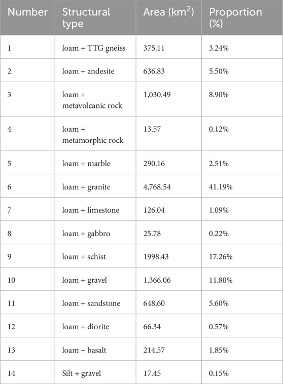
Table 1. Configuration area of each substrate layer in study area.
4.1 Physical properties of soil derived from different parent rocks
4.1.1 Granulometric Characteristics
According to the following Fork and ward formula (1957), several parameters such as mean particle size (Mz), standard deviation (
−1.00 < SK < −0.3, strongly negative. −0.30 < SK < −0. 10, negative. −0.10 < SK < 0.10, near-symmetrical. 0.10 < SK < 0.30, positive. 0.30 < SK < 1.00, strongly positive.
0.67 > KG, very platykurtic (extremely flat-peaked), 0.67 < KG < 0.90, platykurtic (flat-peaked), 0.90 < KG < 1.11, mesokurtic. 1.11 < KG < 1.50, leptokurtic. 1.50 < KG < 3.00, very leptokurtic, KG > 3, hyperleptokurtic.
The statistical analysis is shown in Table 2. Referring to the table, the highest value of the median trend is Cenozoic basalt, carbonate rock, volcanic rock, etc., and the lowest value is metagranulite, diorite, metavolcanic rock, etc. Generally, the grain size of sedimentary rocks is finer, followed by intrusive rocks. Metamorphic rocks are coarser, and the older rocks have coarser soil grain size. The Proterozoic granites are coarser than the Mesozoic granites, and the oldest TTG gneiss has the coarsest grain size. The mean values of volcanic rocks (basalt, volcanic rocks) and carbonate rocks are significantly higher than those of metamorphic rocks (schist, Leptynite) and some granites, which may reflect that some properties (such as alkalinity and mineral content) of their parent materials are stronger after weathering. From the standard deviation, the median values of all samples are between 1.1 and 1.6, indicating the overall sorting difference, and the distribution trend is consistent with the grain size, where the Cenozoic basalt is the best sorted, followed by carbonate rock, volcanic rock, marble, Mudstone/Shale; and the poorly sorted are proterozoic granite, schist, metavolcanic rock, TTG gneiss and Mesozoic granite. The composition of magmatic rocks (such as diorite) and metamorphic rocks (leptynite) may be more uneven, resulting in large data dispersion; Basaltic rocks and basalts have better compositional uniformity. The median value of kurtosis is 0.9–1.11, which is normal peaked, except for volcanic rocks, which is sharp-peaked at 1.165. The skewness ranges near-symmetrically from −0.1 to 0.1, except for the small number of variodiorite and leptynite samples.
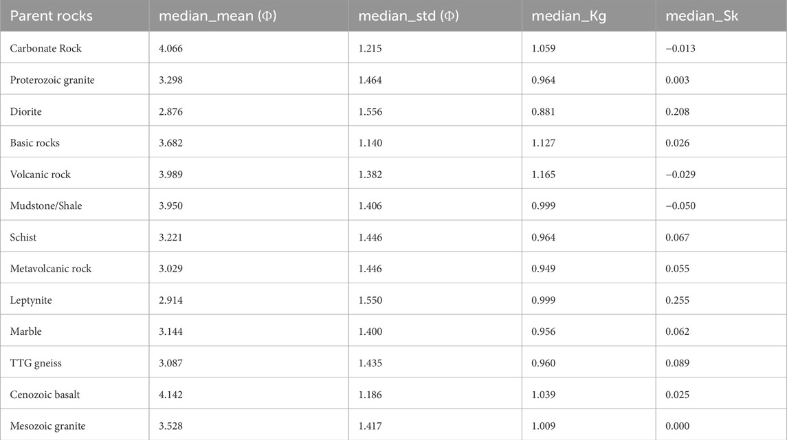
Table 2. Statistical table of soil grain size characteristics developed from different parent rocks.
4.1.2 pH
Since pH value is a logarithmic reflecting a geometric relationship, geometric mean is more suitable for handling multiplicative data or lognormal distribution data. Due to the logarithmic normal distribution of hydrogen ion concentration, the geometric mean (equivalently, calculating the arithmetic mean of hydrogen ion concentration and then converting it back to pH value) can more accurately reflect the central trend of the data. However, the median (the value ranked in the middle) is very robust and not strongly affected by extreme outliers. Thus, when the pH data distribution does not fully conform to logarithmic normality or there are some outliers, the median can provide a more stable and representative “typical” value. The median and geometric mean values are used when obtaining the statistical parameter characteristics of soil, without considering the arithmetic mean value.
Basic rock and diorite have small sample sizes hence have poor representative significance. Cenozoic basalt has the lowest pH value, followed by Mesozoic granite, proterozoic granite, schist, metavolcanic rock, volcanic rock, TTG gneisses, carbonate rock, Mudstone/Shale and marble, indicating that the pH value of the soil developed by magmatic rocks is lower than that of sedimentary rocks, while the basic rocks in magmatic rocks are lower than that of Intermediate-acid rocks (Table 3). In neutral soils (pH 6.5–7.5), marble has a median value of 6.56 and a geometric mean of 6.34. Marble is composed of carbonate minerals (such as calcite and dolomite), and carbonate ions are released (CO2-) from weathering, significantly increasing the soil pH value and forming a weakly alkaline environment. Although pH values in the table do not exceed 7.0, the pH of marble is significantly higher than that of other parent materials, which may be due to different sampling areas or weathering degrees, leading to a less alkaline environment. Acidic soils (pH 5.0–6.5) include carbonate rocks (pH 5.52–5.66), volcanic rocks (5.49–5.62), Mudstone/Shale (5.74–5.82), and TTG gneiss (5.62–5.61). The weathering process of carbonate rocks is dominated by the dissolution of carbonate, but it may not reach strong alkalinity due to regional differences (such as rainfall leaching). Volcanic rocks such as basalt contain alkaline minerals (such as feldspar) which, after weathering, release Na+ and K+ ions, maintaining a neutral to slightly acidic pH. Mudstone/Shale: Strong cushioning by clay minerals and organic matter, slightly higher pH, but may fluctuate under the influence of organic acids. Acidic soils (pH < 5.0) contain basic rocks (pH 4.72), Cenozoic basalt (4.82–5.07). Basic rocks are rich in ferromagnesia minerals (e.g., Pyroxene, olivine) and weathering produces acidic ions such as Fe3+, Al3+, which significantly reduces soil pH. Although Cenozoic basalts are categorized under basic rock, they experience a shorter weathering time or contain small amounts of alkaline minerals (such as plagioclase), hence have a slightly higher pH than typical basic rock.
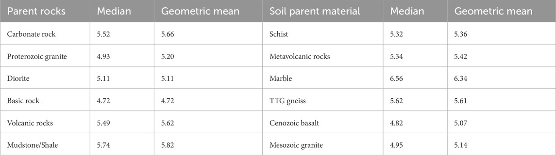
Table 3. Statistical Table of Soil pH Characteristics Developed from Different Parent Rocks.
The influence of parent material type on pH is as follows: (1) lithological composition dominates. Carbonate rocks (marble, carbonate rocks): pH is the highest (>6.0), and alkaline ions are the main weathering products. Basic-ultrabasic rocks (basic rocks, basalts): lowest pH (<5.0), decomposition of ferromagnesia minerals leads to acidity. Granite (Proterozoic/Mesozoic granite): moderate pH (4.93–5.20), silicate minerals (such as quartz, feldspar) weathering slowly, acid leaching predominates. (2) Transitional properties of metamorphic rocks. Schist, metavolcanic rock, TTG gneiss: pH ranges from 5.32 to 5.62, related to the composition of the original rock and metamorphism process. For example, metavolcanic rocks (5.34–5.42) have a slightly lower pH than primary volcanic rocks (5.49–5.62), which may be the result of the release of acid substances from mineral recombination during metamorphism. (3) cushioning of sedimentary rocks. Mudstone/Shale (5.74–5.82): the pH is slightly higher than that of igneous rocks, due to the buffering effect of adsorption of cations by clay minerals and decomposition of organic matter.
4.1.3 Surface bulk weight characteristics
Bulk weight (weight per unit volume of soil) is a direct linear measurement. In bulk weight analysis, the data is measured on a linear scale and usually follows a normal distribution, so the arithmetic mean is calculated selected to most intuitively and accurately reflect its average level.
Diorite, basic and granitic rocks have small sample sizes and do not have statistical characteristics. The number of other samples is more than 10, and the number of Mesozoic granites is more than 100. Referring to Table 4, the bulk weight of magmatic rocks (basalt, volcanic rocks) and metamorphic rocks (schist, metavolcanic rocks) is higher (>1.30), which may be due to the dense minerals or the compact structure of weathering products; Sedimentary rocks (Mudstone/Shale) and some granites (proterozoic granite) have medium bulk weight (1.20–1.30); Granitic rocks and basic rocks have the lowest bulk weight (<1.20), which may be related to their mineral composition or high porosity after weathering.
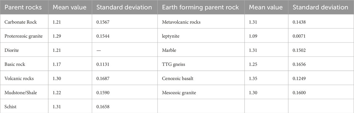
Table 4. Statistical Table of Soil Bulk weight Characteristics of Different Parent Rocks.
Relationship between parent rock type and bulk weight.
1. Magmatic rock. Cenozoic basalt (1.35) has the highest bulk weight, which may be the result of a dense structure formed by rapid cooling, and ferromagnesia minerals (such as pyroxene) have high clay content and strong compactivity after weathering; Volcanic rock (1.30) is similar to basalt, but has a larger standard deviation (0.1687), which could be due to the diversity of volcanic rock types (such as andesite, rhyolite) leading to significant differences in bulk weight. Proterozoic granite (1.29) and Mesozoic granite (1.30): the bulk weight is similar, but the standard deviation of Proterozoic granite is slightly lower, reflecting a more uniform weathering process.
2. Metamorphic rocks. Schist (1.31) and metavolcanic rocks (1.31) have high bulk weight, which may be related to the schistosity structure or the enhanced densification after mineral recrystallization; Leptynite rock (1.09) is significantly lower than other parent rocks, and has a very low standard deviation (0.0071), which may be due to the formation of light minerals (such as quartz, mica) or organic matter enrichment during metamorphism, and high porosity.
3. Sedimentary rocks. Mudstone/Shale (1.22) has medium bulk weight and strong compactibility of clay minerals, but organic matter or bedding structure may increase porosity; Carbonate rock (1.21): Low bulk weight, possibly due to dissolution of carbonate to form solution pores, or loose weathering products. (4) Others. Basic rock (1.17):
Magmatic rock with the lowest bulk weight, which may be the result of mixing of clay particles with organic matter after weathering, or the parent rock containing more pores.
Dispersion of bulk weight (standard deviation):
High dispersion (standard deviation > 0.15): TTG gneiss (0.1656), volcanic rock (0.1687), schist (0.1658). Complex parent rock composition or large weathering environment difference (e.g., rainfall, temperature affect mineral decomposition rate). Low dispersion: leptynite (0.0071): highly homogeneous bulk weight, possibly due to metamorphic process stability or single sampling area. Basalt (0.1131), Cenozoic basalt (0.1249): Weathering products are relatively homogeneous.
High bulk weight soil (such as basalt, schist): the advantages are strong erosion resistance and good water and fertilizer retention. The disadvantage is poor permeability, which may limit root growth and require improvement (such as adding organic amendments). Low bulk weight soil (such as leptynite, basic rock): the advantage is good air permeability, suitable for root development. The disadvantage is prone to nutrients leaching, water retention measures need to be strengthened. The parent rock of soil formation significantly affects soil bulk weight through mineral composition and weathering product characteristics: dense magmatic/metamorphic rocks (basalt, schist) have high bulk weight and compact structure; Light metamorphic rocks (leptynite) and some basic rocks have low bulk weight and are loose and porous; The standard deviation reflects the homogeneity of the parent rock, and the high discrete parent rock needs targeted management. In conclusion, the analysis can provide scientific basis for agricultural planning, soil improvement and engineering site selection.
4.2 Chemical properties of soils derived from different parent rocks
4.2.1 Distribution characteristics of major elements
Parent rock classification and element composition rule.
The content of each index is shown in Table 5.
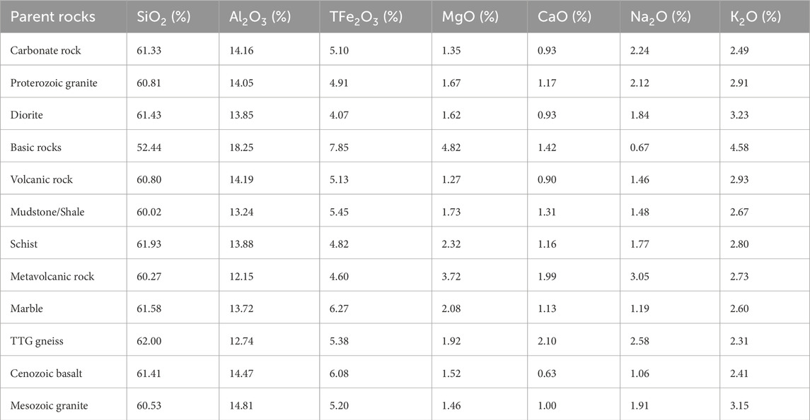
Table 5. Distribution table of major elements in soil developed from different parent rocks.
Acid rocks: Proterozoic granite, Mesozoic granite, TTG gneiss. It is characterized by high SiO2 content (60.53%–62.00%), which is in line with the high silicon characteristic of acid rocks; K2O > Na2O: implies the dominance of potassium feldspar (KAlSi3O8), such as Mesozoic granite (K2O = 3.15%) being significantly higher than Na2O8 (1.91%). Al2O3 is moderate (12.74%–14.81%) and is associated with feldspar and mica minerals.
Basic rocks: mafic rocks, Cenozoic basalts. Characterized by low SiO2 (basic rocks 52.44%, basalt 61.41%), basalt SiO2 may be high due to siliceous minerals (such as plagioclase) or weathering enrichment; High Fe, Mg, and basic rocks TFe2O3 = 7.85%, MgO = 4.82%, reflecting that ferromagnesia minerals (pyroxene, olivine) dominance. High K2O (basic rocks 4.58%) anomaly: may contain potassium feldspar or altered minerals (e.g., Chlorite).
Carbonate rocks: carbonates, marble. It is characterized by low CaO (0.93% in carbonate rock and 1.13% in marble). Abnormality: typical carbonate rocks should be rich in CaO (such as limestone CaO >30%), the working area may lose calcium due to the mixing of siliceous impurities or weathering. High SiO2 (61.33%–61.58%) indicates siliceous cemented or mixed deposits (e.g., siliceous limestone).
Metamorphic rocks such as schist, metavolcanic rocks, and leptynite are characterized by high MgO (3.72%), Na2O (3.05%) of metavolcanic rocks, inheriting volcanic rocks characteristics or enrichment during metamorphism; Schist elements are close to volcanic rocks, but MgO (2.32%) and Al2O3 (13.88%) are moderate, and are associated with mica and chlorite schistocene structure.
Sedimentary rocks such as mudstone and shale are characterized by medium SiO2 (60.02%) and low K2O (2.67%), dominated by clay minerals (such as kaolinite), low potassium feldspar content, and high TFe2O3 (5.45%): may contain hematite or pyrite oxidation products.
4.2.2 Correlation and geochemical significance of key elements
SiO2 content: TTG gneiss (62.00%) > schist (61.93%) > marble (61.58%) > basic rocks (52.44%). The overall pattern is: acid rock (granite, gneiss) > metamorphic rock, volcanic rock > basic rock, which conforms to the classification standard of rock.
Fe-Mg-Ca composition: the basic rocks contain rich TFe2O3 (7.85%) and MgO (4.82%), moderate CaO (1.42%), reflecting the dominant ferromagnesia minerals; The MgO (3.72%) and CaO (1.99%) of metavolcanic rocks are high, which may indicate that the original rocks are basic volcanic rocks and the minerals recombine after metamorphism.
Alkali metals (K2O and Na2O): potassic-rich parent rocks, base rocks (K2O = 4.58%), diorite (3.23%), Mesozoic granite (3.15%); Sodium-rich parent rocks, metavolcanic rocks (Na2O = 3.05%), TTG gneiss (2.58%); High K2O is associated with potassium feldspar or biotite, and high Na2O reflects plagioclase or sodium alteration.
4.2.3 Pedogenic processes, element mobility, and soil impacts
Silica-Alumina Ratio (SiO2/Al2O3): high ratios (e.g., TTG gneiss 4.87) indicates strong weathering resistance and sandy soil. Low ratios (e.g., 2.87 for basic rocks) indicates intensive weathering and clay-rich soils.
Base Cations (Ca2+, Mg2+, K+, Na+): Basic-rocks and Metavolcanic rocks are rich in base cations (high in MgO, CaO, K2O), and may develop high fertility soils; Mudstone/sheet rock contain low base cations, implementing organic-dependent fertility.
Soil property controls: High SiO2 parent rock (granite, gneiss) is sandy with low bulk intensity and good permeability after weathering; High Fe-Mg parent rock (basic rock) has more clay particles, high bulk weight and strong water retention; High K2O parent rock (basic rock, diorite) provides potassium, suitable for potassium crops; Low CaO parent rocks (abnormal carbonate rocks) may cause soil calcium deficiency and need artificial replacement.
In conclusion, parent rock major elements significantly dictate soil evolution pathways: acidic rocks (granites) form sandy, low salt base soil; Basic rocks (basalts) form clay and iron-magnesia-rich soil; Metamorphic rocks (schist, metavolcanic rocks) have complex elemental characteristics, which need to be combined with the analysis of primitive rocks and metamorphic processes.
The principal component analysis was conducted for the major elements, with the first principal component load as the x-axis and the second principal component load as the y-axis, and the scores of various samples in the first principal component and the second principal component were projected on the graph to make a biplot of the principal component. Referring to Figure 2, the positive load of the first principal component is SiO2, Al2O3, TFe2O3, (K2O), etc., and the negative load is CaO, MgO, Na2O; The positive load of the second principal component is MgO, TFe2O3, (CaO), and the negative load is Na2O, SiO2, and K2O. According to the distribution of high loading elements in the principal component analysis, samples projected in the Al2O3-TFe2O3 area were classified as Zone 1, those projected in the TFe2O3-MgO area as Zone 2, those projected in the MgO-CaO area as Zone 3, those projected in the CaO-Na2O area as Zone 4, and those projected in the Na2O-SiO2 area as Zone 5. Based on the projection results of soil samples from different parent rocks, soils developed in the Cenozoic basalt area are mainly distributed in Zone 1, with high contents of TFe2O3 and Al2O3. Soils developed in the basic rock area are mainly distributed in Zone 2, with high contents of MgO and TFe2O3. Soils developed from TTG gneiss and metamorphic volcanic rocks are mainly distributed in Zone 4, with high contents of CaO and Na2O. Soils developed from Mesozoic granite are mainly distributed in Zone 5, with high contents of Na2O, SiO2 and K2O. In addition, soils from Proterozoic granite are mainly distributed in Zone 4-5, with high contents of CaO and Na2O. Schist soils are mainly distributed near the loadings of MgO and K2O, with high contents of MgO and K2O. Soils developed in the marble and carbonate rock area are relatively dispersed. This indicates that the parent rock has a controlling effect (or is an influencing factor) on the chemical composition of the soil during the soil formation process. The enrichment characteristics of TFe2O3 and Al2O3 in the soil developed in the Cenozoic basalt area are closely related to the fact that the parent rock is rich in iron-magnesium minerals and releases aluminosilicate components easily during weathering. This type of soil shows a strong trend of desilication and aluminization during its evolution, further strengthening its chemical composition characteristics; the feature of soils developed in the basic rock area being rich in MgO and TFe2O3 is related to the high content of iron-magnesium minerals such as olivine and pyroxene in the parent rock, which release a large amount of Mg and Fe elements after weathering; while the soil developed from TTG gneiss and metamorphic volcanic rocks is rich in plagioclase, which is easily weathered to form soil rich in Ca and Na, thus distributed in Zone 4; Mesozoic granite is rich in potassium feldspar and sodium feldspar, which release K+, Na+ and SiO2 after weathering, resulting in the aggregation of soil in Zone 5. Although Proterozoic granite is relatively old, it still retains the characteristics of feldspar minerals, so the chemical composition of the soil is similar to that of Mesozoic granite. Schist is rich in biotite and chlorite, which release Mg and K after weathering, thus projected near the loadings of MgO and K2O. Marble and carbonate rocks are mainly composed of CaCO3, which is easily dissolved, and due to the impurity of marble and carbonate rocks and the significant influence of later leaching, the soil distribution is dispersed and deviates from the typical area. This series of patterns indicates that the type of parent rock fundamentally shapes the geochemical pattern of the soil by controlling the initial mineral composition and weathering behavior. Different rocks form characteristic patterns of element enrichment or loss during weathering due to differences in mineral stability, element release rates and migration capabilities, thus showing clear regional aggregation in the principal component space. This geochemical signal dominated by the parent material is retained even after long-term weathering, reflecting the deep coupling between geological history and surface processes.
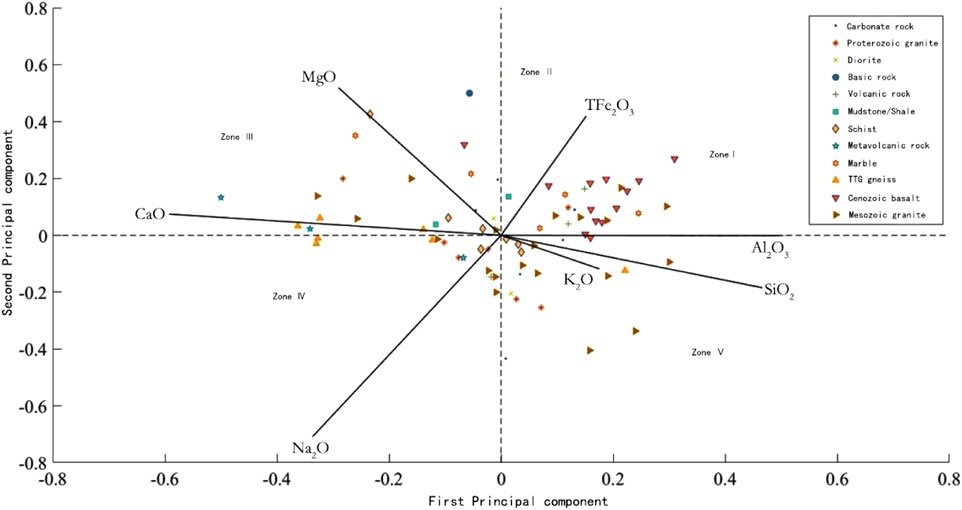
Figure 2. Biplot of principal component analysis of major elements in the research area.
4.2.4 Analysis of weathering intensity in soil derived from different parent rocks
The weathering intensity is one of the important characteristics of soil. It is the result of the comprehensive action of many factors and the comprehensive reflection of the physical and chemical properties of soil (Feng et al., 2003). According to major elements, the silica-aluminum ratio (Sa) and chemical index of alteration (CIA) of each soil sample were calculated (Li et al., 2022) to analyze the weathering intensity of the soil.
The Sa value of soil refers to the total amount of SiO2 and Al2O3 in the soil divided by their respective molecular weights, and then the molecular ratio of the two is obtained. Formula Sa = SiO2/Al2O3. SiO2 and Al2O3 are in mole fractions.
The chemical index of alteration (CIA) is the total amount of Al2O3, CaO, Na2O and K2O in soil divided by their respective molecular weights to find the change in the relationship between the elements.
CIA=(Al2O3)/(Al2O3+CaO*+ Na2O + K2O), and the mole fraction of each element is used, where CaO* only refers to the molar percentage of CaO in silicate minerals. It is necessary to correct the Ca in carbonate minerals and phosphate minerals, which generally uses the content of CO2 and P2O5 obtained from experiments, however, as the CO2 data was not obtained, the Mclennan’s method was adopted to correct P2O5: if CaOcorrected > Na2O then CaO* = NaO, and if CaOcorrected ≤ Na2O then CaO* = CaOcorrected.
According to the calculated CIA and Sa values, the Sa value is taken as the x-axis and the CIA value as the y-axis for each sample type, and the diagram, is projected separately (Figure 3).
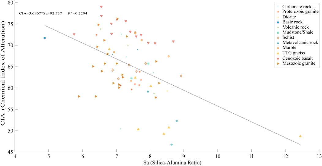
Figure 3. Diagram of soil silicon aluminum ratio and chemical weathering index for different parent rocks.
The overall CIA value of the soil developed by Cenozoic basalt is high, while the silica-aluminum ratio is slightly low. The soil developed by TTG gneiss and metavolcanic rock has low CIA value, while the Sa value is high, and a few TTG gneiss samples exceeds 12. The range of CIA and Sa values in the soils developed by Mesozoic granites is wide, while the distribution range of CIA and Sa values of the soils developed by Proterozoic granites is narrow and generally within the moderate range. Compared with metavolcanic rocks, the soil developed by volcanic rocks has a higher CIA and a lower Sa. The soil with basic-rock development has the lowest Sa values, but the CIA is relatively high. The CIA and Sa of the schist developed soil are both within a moderate range. In addition, the CIA of marble is high and Sa is medium. It can be seen from the figure that the CIA has a weak negative correlation with the Sa.
The average silica-aluminum ratio (Sa) and chemical index of alteration (CIA) values of various samples were calculated (Table 6). Referring to Table 6, the CIA of the soil developed by Cenozoic basalt is the highest, followed by basic rock, volcanic rock, marble, schist, Mesozoic granite, carbonate rock, diorite, Mudstone/Shale, proterozoic granite, and the lowest is metavolcanic rock, which followed by the TTG gneiss, both of which are far lower than the soil developed by other types of rock. The weathering index of basic magmatic rocks is generally higher than that of sedimentary rocks, while the weathering index of acidic magmatic rocks is similar or slightly lower than that of sedimentary rocks. Generally, basic rocks have higher CIA than acidic rocks, carbonate rocks in sedimentary rocks have higher CIA than Mudstone/Shale, the weathering index of specific metamorphic rocks such as TTG gneiss and metamorphic volcanic rocks is the lowest and has close correlation with the metamorphism degree and stable minerals in rocks. The Sa values are the highest for TTG gneiss and metavolcanic rocks, and the lowest for basic-rocks. It shows that lithology is an important controlling factor for the soil forming process.
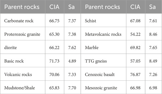
Table 6. Table of average values of weathering index CIA and silicon aluminum ratio (Sa) of soils developed from different parent rocks.
4.2.5 Distribution characteristics of beneficial trace elements
The median values of eight kinds of beneficial trace elements, such as B, Mn, S, Se, Mo, N, Cl and P, were calculated for the soils developed by various parent rocks, and compared with the national soil geochemical baseline values (Wang, 2016), the enrichment factors were obtained (Table 7).
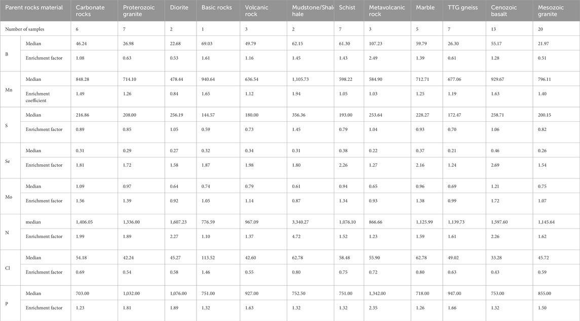
Table 7. Characteristics of beneficial trace elements in soils developed from different parent rocks.
Referring to Table 6, most of the enrichment factors of B in this area are greater than 1, among which the metamorphic volcanic soils are the highest, reaching 2.49, followed by basic rocks, Mudstone/Shale, schist and Cenozoic basalt, with enrichment factor values greater than 1.2, showing enrichment characteristics. The soil developed by volcanic rocks and carbonate rocks is slightly higher than the national soil geochemical baseline values, and TTG gneiss, Mesozoic granite, proterozoic granite, diorite, etc. Are significantly lower than the national soil geochemical baseline values.
The overall Mn enrichment factor is greater than 1. The soil developed by Mudstone/Shale has the highest enrichment factor value, followed by basic rock and Cenozoic basalt, with values greater than 1.5, indicating relatively rich Mn. The values of carbonate rock, Mesozoic granite and marble are all greater than 1.2, indicating weak enrichment, while the values of TTG gneiss, volcanic rock, schist and metavolcanic rock are between 1.0 and 1.2, indicating weaker enrichment, and Mn in diorite is slightly lower than the national baseline.
Nearly all elements enrichment factor of S is below 1, indicating that the area has a generally low S background. The enrichment factor of S in the developed soil of Mudstone/Shale is the highest, which is 1.45, indicating relatively high enrichment, while the Cenozoic basalt, metasurvite and diorite is slightly higher than 1, indicating a normal background, and the other values are less than 1, indicating a low background.
The enrichment factor of Se is the highest in the soil developed by Cenozoic basalt, which is 2.69, indicating strong enrichment, followed by marble with a value of 2.16. The background characteristics of Se content in the soils developed from other types of rocks are relatively high, and the enrichment coefficients of all of them are higher than 1. The enrichment factors of Mo are all greater than 0.9, indicating the characteristics of high background to enrichment. The soil developed from Cenozoic basalt is the most enriched, followed by proterozoic granite, carbonate rock, marble and schist, all of which are greater than 1.2, indicating weak enrichment to moderate enrichment. The values of volcanic rocks, Mesozoic granites and basic rocks are 1–1.2, showing high background characteristics, while the soils of other types of parent rocks show low background characteristics.
The enrichment factors of N are greater than 1 for all samples, the highest is the soil developed by Mudstone/Shale, followed by the soil developed by diorite and Cenozoic basalt, whose values are all greater than 2, indicating strong enrichment. In addition, the soils developed by carbonate rocks, proterozoic granites, Mesozoic granites, TTG gneiss and schist range between 1.5 and 2, indicating moderate enrichment. The values of the soils developed by metavolcanic rocks and volcanic rocks are between 1.2 and 1.5, showing weak enrichment, and the others show moderate to high background.
The enrichment factors of Cl of the soil developed by the basic rocks is 1.46 which is the highest, showing weak enrichment, while other parent rocks have enrichment factors less than 0.8, showing weak depletion.
The enrichment factor of P is 1.23–2.35, showing the characteristics of weak enrichment to strong enrichment, in which the soil developed by metasvolcanics shows strong enrichment, diorite, proterozoic granite, TTG gneiss, Mesozoic granite shows moderate enrichment, and the others are weak enrichment.
5 Conclusion
1. Parent Rock Control on Soil Physical Structure
- Granulometric Characteristics: Sedimentary rock-derived soils exhibit the highest clay content (controlled by primary fine-grained sedimentation), followed by intrusive rocks, while metamorphic rocks yield the coarsest textures (sand-dominated). Archean TTG gneiss, having undergone the longest weathering duration, produces the coarsest soil textures (coarse sand >60%), demonstrating the coupling effect of parent rock age and weathering history.
- Bulk weight Variations: Cenozoic basalt-derived soils show the highest bulk weight (1.35 g/cm3), linked to dense weathering products of ferromagnesian minerals. In contrast, carbonate rock- and Mudstone/Shale-derived soils exhibit the lowest bulk densities (<1.22 g/cm3), reflecting dissolution-induced porosity and organic matter enrichment.
2. Parent Rock Regulation of Soil Chemical Properties
- Acid-Base Dynamics: Magmatic rocks generally display lower pH than sedimentary rock-derived soils (mafic rock pH < 4.8 vs. carbonate rock pH > 6.5), attributed to differential acid leaching of ferromagnesian minerals and carbonate buffering. Mafic rocks (e.g., basalt) induce stronger soil acidification than intermediate-acid rocks due to higher Fe3+ and Al3+ release.
- Element Inheritance: Spatial distributions of major elements (SiO2, Al2O3, K2O, etc.) align closely with parent rock composition. Principal Component Analysis (PCA) confirms >70% contribution from parent rocks to soil geochemical signatures.
3. Weathering Process Dependency on Parent Rocks
- Weathering Intensity: Magma exhibit significantly higher Chemical Index of Alteration (CIA) values than sedimentary rocks (mafic rock CIA >85 vs. mudstone CIA <75). Metamorphic rocks, rich in stable minerals (quartz, muscovite), show the lowest CIA (≈65).
- Weathering Pathways: Carbonate rock weathering is dissolution-dominated (low CaO residue), whereas magmatic rocks primarily involves silicate hydrolysis (high clay mineral formation).
This study reveals that the parent rock properties control the formation and evolution of black soil through three mechanisms: physical structure shaping, chemical element inheritance and weathering path differentiation, which breaks through the traditional research paradigm of single environment driven soil science. The results can provide a geological theoretical framework for the accurate conservation of “zoning-classification - grading” in the Northeast China’s black soil region, and provide a plan for the sustainable use and management of black soil in similar climate zones around the world.
Data availability statement
The original contributions presented in the study are included in the article/supplementary material, further inquiries can be directed to the corresponding authors.
Author contributions
ZC: Writing – original draft, Writing – review & editing, Conceptualization, Methodology. XC: Writing – review & editing, Writing – original draft, Methodology. YT: Writing – original draft, Formal Analysis. DH: Writing – original draft, Data curation. XA: Writing – original draft, Investigation. GG: Writing – review and editing, Conceptualization.
Funding
The author(s) declare that financial support was received for the research and/or publication of this article. This research was funded by the research “1:250,000 Ground Substrate Survey in the Luzhong Hilly Region” was funded by China Geological Survey, grant number DD20243192, and the research “Precise Allocation of Spatiotemporal Soil Evolution Patterns and Zoning-based Conservation Technologies in Black Soil Regions”, grant number 2023YFD1500100. The APC was funded by the Center for Geophysical Survey, China Geological Survey.
Conflict of interest
The authors declare that the research was conducted in the absence of any commercial or financial relationships that could be construed as a potential conflict of interest.
Generative AI statement
The author(s) declare that no Generative AI was used in the creation of this manuscript.
Any alternative text (alt text) provided alongside figures in this article has been generated by Frontiers with the support of artificial intelligence and reasonable efforts have been made to ensure accuracy, including review by the authors wherever possible. If you identify any issues, please contact us.
Publisher’s note
All claims expressed in this article are solely those of the authors and do not necessarily represent those of their affiliated organizations, or those of the publisher, the editors and the reviewers. Any product that may be evaluated in this article, or claim that may be made by its manufacturer, is not guaranteed or endorsed by the publisher.
References
Chinese Academy of Sciences (2021). Northeast black land white paper (2020). Beijing,China: Chinese Academy of Sciences.
Cui, M., Zhang, X. D., Cai, Q. G., Wang, Y., Fan, H. M., and Zhou, J. X. (2008). Relationship between black soil development and climate change and geomorphological evolution in Northeast China. Geogr. Res. 27 (3), 527–535.
Feng, L. J., Chu, X. L., Zhang, Q. R., and Zhang, T. G. (2003). CIA (chemical index of alteration) and its applications in the world Neoproterozoic clastic rocks. Earth Sci. Front. 10 (4), 539–544.
Ge, L. S., and Yang, G. C. (2020). New field of natural resources survey and monitoring: substrate survey. Nat. Resour. Econ. China, 33 (9), 4–11. doi:10.19676/j.cnki.1672-6995.000432
Gu, Y. C., Li, Y. W., and Yang, C. D. (1993). Principles and methods of site elements for forest site classification and evaluation; Science Press: Beijing, China, 1–143.
Hao, X. X., Wang, C., Zou, W. X., Yan, J., and Han, X. Z. (2023). Study on the relationship between blackness and soil organic matter fractions of typical mollisol. Acta Pedol. Sin. 60 (5), 1421–1429. doi:10.11766/trxb202211160624
Hou, H. X., Zhang, S. J., Lu, M., Zhang, Z. Y., Sun, X., Qin, T., et al. (2021). Technology and method of the ground substrate layer survey of natural resources: taking baoding area as an example. Northwest. Geol. 54 (3), 277–288. doi:10.19751/j.cnki.61-1149/p.2021.03.026
Hou, H. X., Ge, L. S., Sun, X., Kong, X. B., Lu, W. H., Qin, T., et al. (2022). A study on the application of ground substrate in the survey and evaluation of China’s black soil resources: based on ground substrate survey in Baoqing, Heilongjiang province. J. Nat. Resour. 37 (9), 2264–2276. doi:10.31497/zrzyxb.20220905
Kong, F. P., Liu, H. B., He, J. B., Zhao, J., Dong, G. H., Liu, B. W., et al. (2021). 2021 annual progress report on the survey of surface substrate layer of black soil in baoqing area. Mudanjiang, Heilongjiang, China: Mudanjiang Natural Resources Comprehensive Survey Center, China Geological Survey, 10–14.
Li, X. L., Zhang, X., Lin, C. M., Huang, S. Y., and Li, X. (2022). Overview of the application and prospect of common chemical weathering indices. Geol. J. China Univ. 28 (1), 51–63. doi:10.16108/j.issn1006-7493.2020118
Lu, M., Wang, X., Liu, Y., Qiao, Y. Y., Wang, H. H., and Gao, W. B. (2020). Implementation plan for the pilot survey of the groung substrate layer of natural resources in baoding. Hebei.Langfang:Langfang Nat. Resour. Compr. Surv. Center,China Geol. Suevey.
Ministry of Natural Resources (2020). General scheme for construction of natural resources survey and monitoring system. Beijing, China: Ministry of Natural Resources.
Ministry of Natural Resources (2020). Classification scheme for ground substrate (Trial). Beijing, China: Ministry of Natural Resources.
Nanjing Center, China Geological Survey (2014). Specification of multi-purpose regional geochemical survey (1:250,000): DZ/T 0258-2014. Beijing, China: China Standards Press.
Qin, T., Pei, Y., Zhou, Y. Z., Gao, Y., Guan, Y. N., and Liu, W. T. (2021). 2021 annual progress report on the survey of surface substrate layer of black soil in lishu area. Hebei, Langfang: Langfang Natural Resource Comprehensive Survey Center, China Geological Survey, 15–17.
Shao, H., Wang, Y. N., Yin, Z. Q., Xing, B., Jin, A. F., Pang, J. M., et al. (2022). An exploration on investigation and mapping of ground substrate in ruyi river basin, Bashang Plateau, Chengde city. Hydrogeology & Eng. Geol. 50 (2), 150–159. doi:10.16030/j.cnki.issn.1000-3665.202112021
Song, C. Q., Cheng, C. X., Yang, X. F., Ye, S. J., and Gao, P. C. (2020). Understanding geographic coupling and achieving geographic integration. Acta Geogr. Sin. 75 (1), 3–13. doi:10.11821/dlxb202001001
Wang, X. Q. (2016). National soil geochemical baseline values of China. Beijing, China: Geological Publishing House.
Yang, K., Sun, Q. F., Hou, H. X., Yu, J. B., Yin, Q. C., Chen, Y. Y., et al. (2024). Ground substrate survey to support black soil conservation and rural revitalisation: taking hailun city, Heilongjiang province as an example. Nat. Resour. Inf. 11, 9–17.
Yin, Z. Q., Qin, X. G., Zhang, S. J., Wei, X. F., Hou, H. X., He, Z. X., et al. (2020). Preliminary study on classification and investigation of surface substrate. Hydrogeology & Eng. Geol. 47 (6), 8–14. doi:10.16030/j.cnki.issn.1000-3665.202010065
Zhang, X. R., and Jiao, J. Y. (2020). Formation and evolution of black soil. J. Jilin Univ. Earth Sci. Ed. 50 (2), 553–568. doi:10.13278/j.cnki.jjuese.20190262
Zhang, G. L., Song, X. D., and Wu, K. N. (2021). Classification method of Earth's key zones and case study in China. Sci. Sin. Terrae 51 (10), 1681–1692. doi:10.1360/sste-2020-0249
Keywords: black soil, formation and evolution, ground substrate, Changbai mountain foothills, geochemical characteristics
Citation: Chen Z, Chen X, Tang Y, Huo D, Ai X and Geng G (2025) Characteristics and evolution of ground substrate in the black soil area of the residual veins of Changbai mountain. Front. Earth Sci. 13:1648531. doi: 10.3389/feart.2025.1648531
Received: 17 June 2025; Accepted: 08 October 2025;
Published: 31 October 2025.
Edited by:
Miguel Angel Taboada, University of Buenos Aires, ArgentinaReviewed by:
Hao Wei, Hebei GEO University, ChinaRaul Miranda-Aviles, University of Guanajuato, Mexico
Copyright © 2025 Chen, Chen, Tang, Huo, Ai and Geng. This is an open-access article distributed under the terms of the Creative Commons Attribution License (CC BY). The use, distribution or reproduction in other forums is permitted, provided the original author(s) and the copyright owner(s) are credited and that the original publication in this journal is cited, in accordance with accepted academic practice. No use, distribution or reproduction is permitted which does not comply with these terms.
*Correspondence: Guoshuai Geng, aG5zbXhnZ3NAMTYzLmNvbQ==
†These authors share first authorship