 Zhirong Yang
 Haisong Wang*
- Shanghai Academy of Fine Arts, Shanghai University, Shanghai, China
The diversity and heterogeneity of the water network environment in the Jiangnan region have fostered highly distinctive water town settlement spaces. Scientific research on the interactions between water system environments and human settlement spaces is of great significance to the high-quality development of urban-rural integration in the Yangtze River Delta. However, current academic research on the spatial patterns of Jiangnan water town settlements under the influence of “water system-human settlement” coupling remains unsystematic. Therefore, this study takes the Eco-Green Integrated Development Zone (EGIDZ) of the Yangtze River Delta—located in the core area of Jiangnan water towns—as a case study, and uses Geographic Information System (GIS) software combined with the landscape pattern index analysis method to study the spatial typologies and structural characteristics of the “water system-human settlement” coupling in 29 towns within EGIDZ. The study reveals the following. 1) The settlement spaces within the EGIDZ of the Yangtze River Delta generally exhibit an agglomeration pattern characterized by ‘single-core large-scale aggregation with multi-core small-scale dispersion,’ among which linear settlements (including low-density and medium-density ones) have the widest distribution, accounting for 45.2%. 2) The water system environment has a significant impact on the spatial forms and characteristics of settlements in the region; these variations in the pattern of Jiangnan water networks determine the basic type characteristics of settlement spaces (point-like, linear, clustered). 3) Jiangnan water town settlements are constantly evolving alongside natural environments and human activities. The natural environment, especially the water system environment, determines the spatial distribution of early settlements, while human activity factors such as agricultural production and infrastructure construction drive the evolution and development of settlement spatial structures. This study further clarifies the inherent order of commonalities and differences in the spatial typologies and structural characteristics of settlements in Jiangnan water towns, providing a reference framework for future policies on protecting distinctive settlements in “new Jiangnan water towns” and methods for landscape construction.
1 Introduction
1.1 Research background
Understanding the interaction between humans and nature is crucial for achieving global sustainability and enhancing human welfare (Liu et al., 2025). In this interaction, water is irreplaceable to human life and production processes, and is inextricably linked to the formation and development of human settlements (Wu, 2014). The earliest human settlements often emerged in valley plain areas, where water systems supported agricultural development and gave birth to ancient human civilizations (Morris et al., 2018). For instance, the Mesopotamian civilization in the Tigris-Euphrates River plain, the Egyptian civilization in the Nile Valley, and the Chinese civilization in the Yellow River-Yangtze River basin. Over time, human settlements have undergone a remarkable transformation: from the wilderness (dependent on the natural environment) to the countryside (a semi-natural and semi-artificial agricultural environment) and then to the city (expansion of artificial environments) (Liu, 2015).
In recent years, the rapid advancement of urbanization posed a significant threat to natural environments such as water systems, landforms and vegetation, as well as to agricultural and residential environments (Huang et al., 2025a). In particular, the most prominent impact was made on the natural and semi-artificial environments that rural settlements have long relied on.
The Yangtze River Delta, as one of the most economically developed regions in China, contributes approximately one-fifth of the national economic output with 3.7% of the country’s land area and 16.6% of its population (National Bureau, 2024). However, with rapid urbanization, typical Jiangnan water town settlements are facing challenges in protecting their habitat and spatial structures (Zhang et al., 2024). The quick development of cities gradually eroded the characteristics of traditional Jiangnan water towns and intensified conflicts between the water environment and human settlements (Huang et al., 2025b).
In response to this confrontation, the Eco-Green Integrated Development Zone (EGIDZ) of the Yangtze River Delta was established in 2019 with an aim to explore a new paradigm for ecologically friendly development of urban and rural areas. The core area of EGIDZ is Jiangnan water towns. Subsequently, in 2023, the Chinese government approved the Master Spatial Plan for the Eco-Green Integrated Development Zone of the Yangtze River Delta (2021–2035) and put forward green development goals for 2035. As a result, Jiangnan water town settlements became a foundation for high-quality development and in-depth research with interdisciplinary collaboration. Therefore, studies on the classification and spatial morphology of settlements in the EGIDZ provide a scientific basis for the protection and development of the “water system-human settlement” principle. These research also provide theoretical support for the landscape construction and land use development of urban and rural settlements in water systems environments.
1.2 Research review
The diversity and heterogeneity of the water system in Jiangnan cultivated a very distinctive settlement space. Research on the settlement space of Jiangnan water towns has long been a focus of academic attention. In the early 1980s, Yisan Ruan and his research team carried out a series of protection measures focusing on the historical and cultural values of traditional settlements in this region (Ruan and Yuan, 2016). Besides, Jin Duan regarded the poetic landscape of traditional settlements featuring “small bridges, flowing water, and residences (小桥, 流水, 人家)” as the distinctive spatial characteristic of Jiangnan water towns (Duan and Ji, 2002).
In addition, the study of settlement typologies and characteristics of Jiangnan water towns has long been a priority in the fields of architecture, urban planning and landscape science, and is in a phase of stable and rapid development (Li and Song, 2023). In terms of existing research, scholars with different academic backgrounds place different emphasis on their research approaches and methods, leveraging the strengths of their disciplines. For example, based on the general geographical features of the Jiangnan region, where the west is dominated by plains with low mountains and hills, Qiming Jin divided the rural villages around Taihu Lake in Jiangsu Province into mountainous, plains, and lake-marsh types (Jin, 1982). In contrast, Junfan Wu focused on the historical differentiation mechanisms of water town settlement patterns in Jiangnan (Wu, 2016a), arguing that three types of human settlement zones—“low-lying areas,” “high-lying areas,” and “coastal areas”— gradually formed in the Jiangnan water environment region since the Tang Dynasty (Wu, 2016b). Meanwhile, based on the positional relationship of “water systems - human settlements” and the rural survey reports in Wuxi area, Jin Duan classified settlements into spatial patterns characterized by the following features: construction along water, integration of waterways and settlements, surrounded by mountains and water, development along roads (Duan, 2015). As revealed by the literature review analysis (Table 1), current scholars differ in their research perspectives on the spatial types and characteristics of rural settlements within the Jiangnan water system environment. Qualitative classification of spatial types is primarily conducted from dimensions such as geomorphic features, historical geography, positional relationships between water sources and towns, and paddy field landscape patterns.
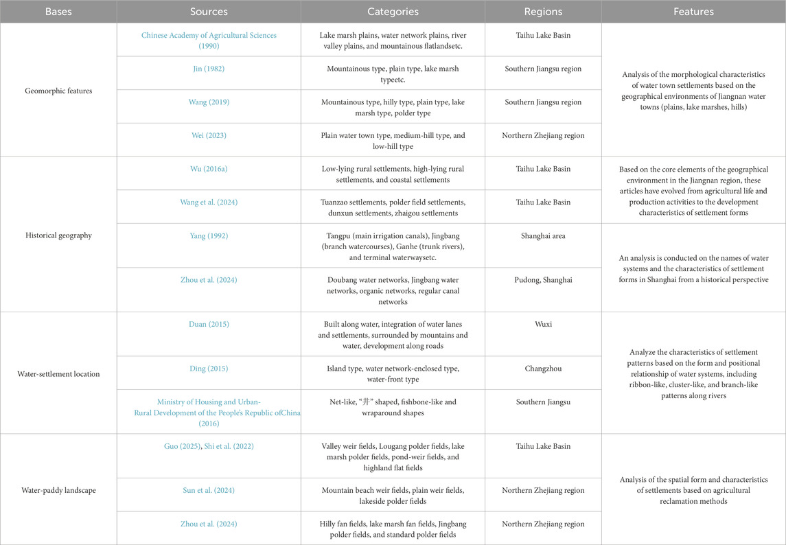
Table 1. Research on spatial typologies and characteristics of settlements in Jiangnan water towns.
In recent years, with the rapid development of computer science and artificial intelligence, the application of intelligent technologies such as remote sensing information (Cai et al., 2025), GIS technology (Huang et al., 2025c), spatial models (Chen et al., 2023), and machine learning (Zhong et al., 2025) made it possible to overcome the limitations of current research on the spatial characteristics of water town settlements. This gradually contributed to methodological innovations and technological transformations in interdisciplinary and integrated research within this field (Huang et al., 2024). For instance, Yipeng Wang extracted 31 samples of vernacular landscape fragments in the Hang-Jia-Hu region using satellite images. By integrating knowledge from disciplines such as environmental history, agricultural history, and human geography, he derived settlement structure types consisting of concepts and abstract schemas (Wang, 2025). Xinqu Liu created 3D village models via ArcGIS and BIM. He also established a water environment spectrum of village spaces within the region by taking 728 traditional villages in the Jiangnan area as research objects (Liu H. et al., 2022). From the perspective of architectural heritage value of ancient settlements, Yuhao Huang conducted quantitative analysis on the spatial forms and characteristics of traditional settlements in the Nanxi River Basin. This analysis considered geographical information such as topography and water systems, as well as historical and cultural factors (Huang et al., 2025d; Huang et al., 2025e). Focusing on the spatiotemporal patterns and accessibility assessment of settlements, Yi Zhang adopted overlay analysis of global (OLS) and local spatial regression (GWR) models. Through these methods, he analyzed the global and local spatial factors influencing the accessibility of traditional villages in the Jiangnan region (Zhang et al., 2024).
Research on the typology of settlement spaces in the Jiangnan water towns has continuously made methodological breakthroughs. However, as revealed by the literature review, current studies still lean heavily towards qualitative analyses of the natural, humanistic, and historical dimensions of settlement spaces. In particular, research describes the characteristics of spatial patterns of rural settlements (Zhang and Zhang, 2022). There is a lack of comprehensive, cross-scale quantitative studies on the relationship between water systems and settlement environments. Furthermore, scientific understanding has not yet been established in terms of their mutual construction and interrelationship.
1.3 Problem statement and objectives
The Tang Dynasty poet Du Xunhe once depicted the intimate connection between the environment of Jiangnan water town and human settlements with the lines, “When you arrive in Gusu, you will see that every household rests upon the river (君到姑苏见, 人家尽枕河).” Due to the diverse forms of water systems in the Jiangnan region, their interactions and mutual influences with settlement spaces manifest at different scales (Zhao and Wang, 2018). A single-scale perspective does not allow to accurately capture the spatial types and internal structural characteristics of rural settlements within such water systems environments (Chen et al., 2022). Therefore, this study focuses on the multi-scale characteristics of “water system-human settlement” paired structure, taking the EGIDZ as an example. It uses the geographic information system to interpret the characteristics of the settlement space in the Yangtze River area, so as to develop ideas and methods for preserving values and recommendations for sustainable construction in the area.
Nowadays, under the value pursuit of ecological and green integrated development in the Yangtze River Delta, a spatial model and ecological safety model are being established where the “water system-human settlements” in the Jiangnan water towns interact and coexist (Wei et al., 2023). Creating the human settlement scenarios of the “new Jiangnan water towns” under the metropolis at multiple spatial scales became a continuous driving force for stimulating the sustainable development of this region. Thereby, this study aims to answer the following research questions: (1) What kind of settlement spatial model does the EGIDZ present in the Jiangnan water network environment? (2) What settlement spatial types and significant characteristics does it possess? (3) How do the settlement spatial forms and structures evolve under the interaction of “water system-human settlements”?
2 Materials and methods
2.1 Study area: the EGIDZ of Yangtze River Delta
“Jiangnan (江南)” is a term with historical origins, which not only generally refers to the geographical concept of “south of the Yangtze River” but also a cultural symbol that embodies elements of China’s history, politics, and economy. However, the scope it refers to has undergone significant changes in history. In fact, scholars in disciplines such as literature, geography, history, and economics have not yet reached a consensus (Wang et al., 2016). It is certain that with the change of dynasties and social development, the core area of “Jiangnan” gradually converged with the area of the Taihu Lake Basin (Li, 2007) (Figure 1). Based on historical documents, survey materials, and the focus of previous studies, the water-based settlements within the water system environment of the Taihu Lake Basin, which express the cultural emotions and imagery elements of Jiangnan, are defined as “Jiangnan water towns”.
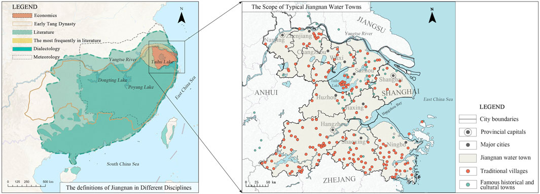
Figure 1. Jiangnan and Jiangnan Water Towns. (Image source: drawn by the author).
The Yangtze River basin is recognized as an ecological security barrier of China (Liu X. et al., 2022). Since ancient times, it has been known as a habitable “land of fish and rice (鱼米之乡)”. The “Jiangnan water towns” based in the Taihu Lake Basin, constitute the core area of China’s “Yangtze River Delta Regional Integration Development.” Located in the subtropical mild and humid monsoon climate zone, these water towns feature four distinct seasons and concurrent rainfall and heat. The average monthly temperature in summer ranges from 25 °C to 30 °C. Such climatic conditions, combined with the complex water system of the Taihu Lake Basin, shaped the unique agricultural landscape of the region and laid a solid foundation for its long-term prosperity and cultural continuity.
In 2019, the Eco-Green Integrated Development Zone (EGIDZ) of the Yangtze River Delta (30°45′36″–31°17′24″E, 120°21′36″–121°19′48″N) was established. It is located at the intersection of provinces Jiangsu, Zhejiang and Shanghai, including Wujiang District of Suzhou City, Jiashan County of Jiaxing City and Qingpu District of Shanghai.
The EGIDZ covers a total land area of approximately 2,413 km2. Due to the geographical location, it stands as a core region of typical Jiangnan water towns ((Figure 2). The region is located in the low-lying area on the eastern side of the Taihu Lake Basin and features a flat terrain with dense clusters of lakes. The average altitude is only about 6 m. Its water surface area reaches 438.2 km2, which is 18.16% of the total area. The environment of water systems and human settlement areas are closely interconnected. The region allows us to study this connection and it also reflects the typical characteristics of Jiangnan’s water towns. Based on the relevant data published in the Master Spatial Plan for the Eco-Green Integrated Development Zone of the Yangtze River Delta (2021–2035), the research samples in this study are determined as 29 towns within the region. The rural area among these towns is 1337.8 km2, which is 55.44% of the total area (Zuo and Zhang, 2023).
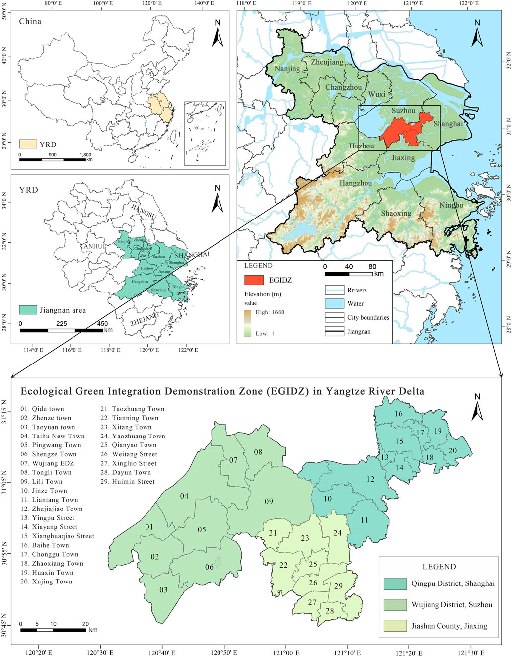
Figure 2. EGIDZ in the Yangtze River Delta. (Image source: drawn by the author).
The unique natural environmental conditions of the Jiangnan water system determine the main functional positioning of EGIDZ as “ecological and green” (Ji et al., 2023). However, the urban sprawl and growing rural construction in recent years have also brought a series of problems. For example, the ecosystem where the water system is dominant has been seriously damaged, which has led to the overall deterioration of the water village style. This is one of the reasons why it is necessary to ensure the protection and development of the local landscape and cultural values (Zhang and Zhai, 2021).
In February 2025, the Executive Committee of the EGIDZ issued and implemented the Special Plan for the Water Demonstration Zone in the Pioneer Zone of the Yangtze River Delta Ecological and Green Integrated Development Demonstration Zone (2021–2035). This plan further clarifies the characteristics of Jiangnan water towns featuring “taking water as the vein and integrating blue and green spaces”. The purpose is to form a settlement spatial system characterized by large-scale dispersion, small-scale concentration, and strong connectivity. This strategic approach emphasizes the ecological value of water systems and provides a clear direction for optimizing the spatial structure of settlements in the region. Therefore, it is urgent to identify and optimize the area of settlements in EGIDZ.
2.2 Data sources and processing
This study uses the data obtained from public databases (Table 2), including: (1) Digital Elevation Model data with a resolution of 30 m, sourced from the Geospatial Data Cloud; (2) Current land use and land cover data with a spatial resolution of 30m, obtained from the National Tibetan Plateau Data Center and the European Space Agency; (3) Spatial distribution data of water systems and basins, etc., derived from the Resource and Environmental Science Data Center of the Chinese Academy of Sciences; (4) Public space data such as roads, infrastructure, and construction land, retrieved from Baidu Maps Points of Interest (POIs); (5) Vector data of the EGIDZ and data related to the functional structure of territorial space, acquired from national administrative boundary data and the Master Spatial Plan for the Yangtze River Delta Ecological and Green Integrated Development Demonstration Zone (2021–2035). The above data (all from 2022) collectively constitute the spatial dataset of this study. In addition, relevant image data within the region were mainly obtained from the government’s Bureau of Natural Resources and Planning, the National Geographical Information Public Service Platform (Tianditu), the website of the United States Geological Survey (USGS), and Google Earth.
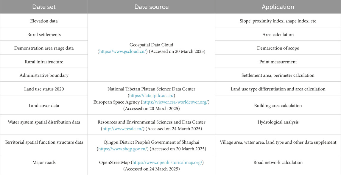
Table 2. The sources of the EGIDZ spatial data.
All indicators were standardized to a data resolution of 100m, and geographical coordinate calibration and spatial information processing were performed in ArcGIS.
2.3 Research methodology
2.3.1 Research framework
This study employs various methods, including historical document analysis, spatial information processing and field surveys, to conduct a digital analysis of the settlement space and structural characteristics in the study area (Figure 3).
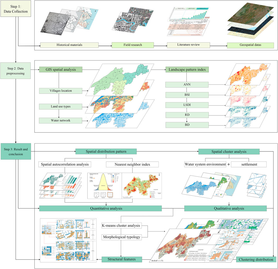
Figure 3. Research framework. (Image source: drawn by the author).
Firstly, based on the GIS spatial analysis method, the following data were pre-processed for visualization and scientific justification: settlement land use types, digital terrain data, hydrological data and infrastructure data. Secondly, processed data were combined with the formula calculation of landscape pattern indices, so it revealed digital analysis results of the morphological characteristics and internal structure of EGIDZ settlement spaces. Thirdly, the qualitative research methods verified the digital results through an investigation of historical documents and an analysis of current state of the settlement water systems and agricultural residential environments. Finally, this study integrates clustering methods and qualitative research to conduct a typological analysis of rural and urban settlement spaces in the region. On this basis, the analysis combines remote sensing imagery and field survey data to examine the evolutionary patterns in the spatial structure within each settlement type. These findings produce a reference framework for sustainable urban-rural development and the protection of traditional settlements.
2.3.2 Methods
Landscape pattern indices form the foundation for understanding settlement spaces. They are technical tools that quantify and measure settlement morphology and spatial characteristics using statistics and spatial analysis (Huang et al., 2025b). This method has the ability to describe the spatial characteristics of settlements and express the interaction of “water system–human settlement” (Hu et al., 2008). At the macro scale, the spatial distribution characteristics of settlements can be explored by the Approximate Nearest Neighbor index (ANN) of settlements. It plays a key role in determining the spatial distribution type and agglomeration degree of settlement points. The calculation method of ANN is shown in Equation 1. When ANN<1, the settlement distribution tends to cluster pattern; when ANN>1, the distribution tends to be random.
Where
The Settlement Boundary Shape Index (BSI) is a mathematical indicator widely used in landscape ecology (Jiang et al., 2025). It can reflect the complexity of the contour shapes of rural and urban settlements at the macro level. The higher the value, the more complex the boundary. The calculation is shown in Equation 2.
Where
The Land Use Diversity Index (LSDI) of settlements indicates the complexity and diversity of the composition between settlement land and other ecological spaces. Ecological space types are classified into nine categories, including forests, grasslands, swamps, lakes, rivers, farmlands, and built environment (Cai et al., 2023). A higher land use diversity implies a more complex spatial structure of land use. The calculation is shown in Equation 3.
Where N is the total number of settlement land types in all villages and towns;
In addition, at the medium and micro scale, the structural differences and correlation characteristics inside the settlements are analysed through Road Density (RD) and Building Density (BD). The calculation is shown in Equations 4, 5.
Where L is the length of the road center line; A is the area; S is the total built-up area of the settlement.
3 Results: spatial typologies and structural characteristics
3.1 Index recognition
The measurement of landscape pattern index enables a quantitative analysis of the EGIDZ’s settlement composition characteristics and spatial structure. Moreover, GIS spatial analysis method can serve for the data visualization.
Figure 4 shows the overall and local spatial correlations of settlement distribution in the Demonstration Zone (EGIDZ). The finding of the study is that the spatial distribution of settlements in this region exhibits the typical pattern characteristics of “single-core large agglomeration and multi-element small dispersion” (Bi et al., 2024) (P > 0.01, Z = 1.78 < 2.58). Spatial clusters mainly show consistency of H-L and L-H, occasionally interspersed with H-H and L-L cluster patterns, where H is for “high” and L is for “low”. From the 29 market towns studied, eight towns such as Wujiang WDG, Shengze Town, Yingpu Street, and Weitang Street show significant spatial clustering. In lake areas such as Dianshan and Yuandang (towns such as Lili town and Jinze town), the agglomeration of settlement areas is small due to the wide distribution of water areas. This indicates that a well-developed water system limits the clustering of settlements and promotes their uniform distribution across the territory.
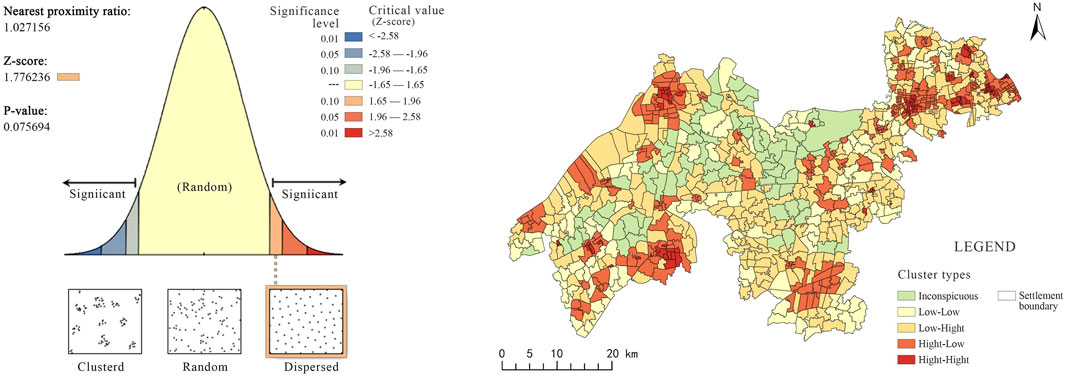
Figure 4. Approximate Nearest Neighbor index (ANN). (Image source: drawn by the author).
In terms of settlement boundaries and the environment, the integration degree of the Boundary Shape Index (BSI) of settlements in the EGIDZ is low with little variation, ranging from a minimum of 0.05 to a maximum of 0.83. The largest proportion falls in the interval of 0.25–0.39. Overall, the rural and urban settlement morphology presents a relatively regular multi-point distribution pattern with low complexity (Figure 5). In town centers and their surrounding areas, a higher economic level leads to more complex settlement patterns. In areas like Wujiang EDZ and Yingpu Street, the complexity of rural and urban settlements morphology shows a tendency to diverge outward. This spatial differentiation indicates that economic development may act as a driving force in shaping settlement boundaries. At the same time, the overall low complexity reflects the constrained influence of the regional natural environment on settlement expansion.
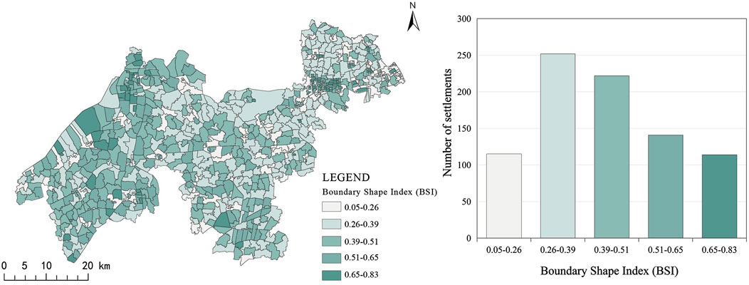
Figure 5. Settlement Boundary Shape Index (BSI). (Image source: drawn by the author).
In terms of settlement land use structure, the Land Use Diversity Index (LSDI) of settlements in the EGIDZ ranges from 0.21 to 1.36. The largest proportion is in the interval of 1.00–1.12, and the overall pattern shows obvious characteristics of east-west differentiation. The dense network of lakes and marshes in Wujiang District generates complex land use patterns. This results in a more intricate structure for the land categories like grasslands, swamps, and water bodies compared to other areas (Figure 6).
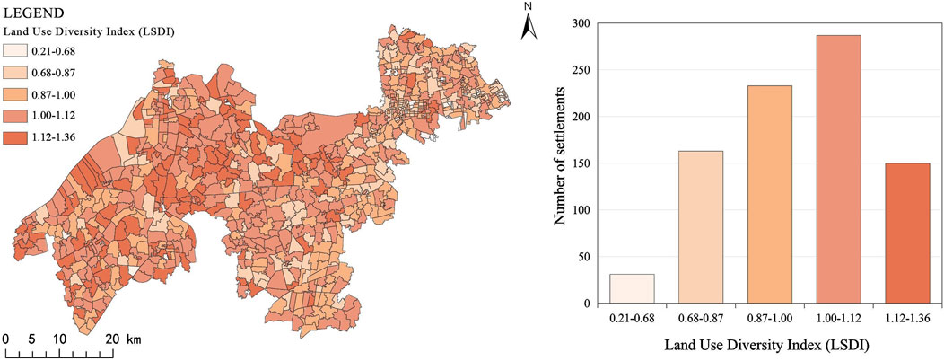
Figure 6. Land Use Diversity Index (LSDI). (Image source: drawn by the author).
There is a positive correlation between settlement building density and road network density. This can intuitively reflect the development level of settlements. Situated across three provincial-level administrative divisions (Jiangsu Province, Zhejiang Province, and Shanghai Municipality), the EGIDZ boasts well-developed internal transportation within its settlements, with generally high road network density (RD). Specifically, 63.3% of the settlements have an RD ranging from 4.46 to 12.18 km/km2 (Figure 7). Driven by the Yangtze River Delta Integration Strategy, the EGIDZ has achieved a leading urbanization level in China. Correspondingly, the building density in its central urban areas and town centers is generally high; among these, Qingpu District of Shanghai registers the highest value (Figure 8), with the maximum density reaching 47%. In contrast, relatively low building density is found in other townships where water areas are extensively distributed, and 66.5% of the settlements in these regions have a building density below 13%.
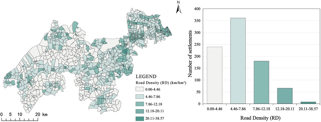
Figure 7. Building Density (BD). (Image source: drawn by the author).
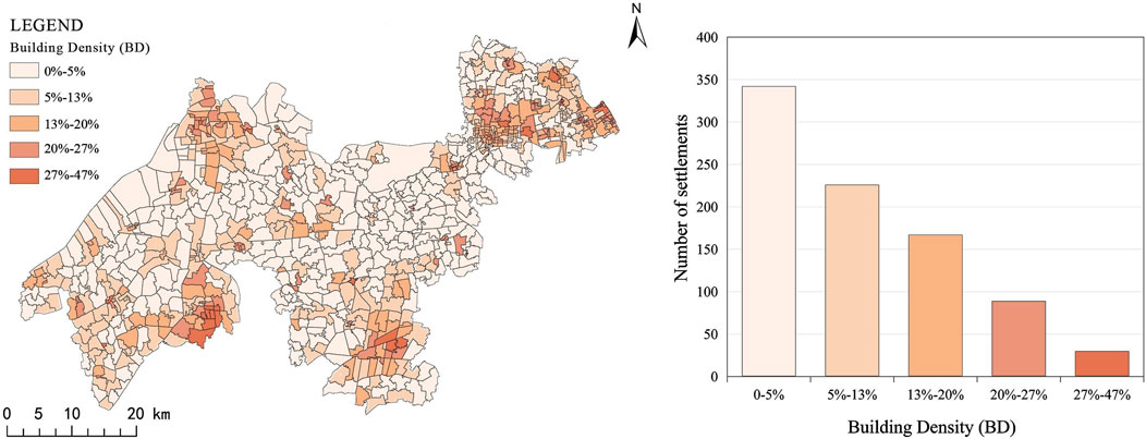
Figure 8. Road Density (RD). (Image source: drawn by the author).
The identification of landscape pattern indices in the EGIDZ reveal the differentiation characteristics of settlement spaces within the water system region. In particular, it shows the correlation between the water systems and human settlements. The water system plays a significant role in urban and rural ecological environments, transportation facilities, and human life. It shapes the basic framework of settlement distribution, affects the operational efficiency of transportation systems and the quality of residents’ daily lives. Thereby, it becomes an irreplaceable element in maintaining the stability and vitality of the regional spatial structure.
3.2 Spatial typologies
The quantitative research on landscape pattern index allows to identify the spatial characteristics of settlements in EGIDZ. This study employs a combination of quantitative and qualitative clustering methods. Combined with historical and typological analysis, this approach performs a detailed clustering analysis of regional settlement space types. This study first quantifies spatial morphological characteristics using settlement landscape pattern indices. It then applies the K-Means clustering method to classify rural and urban settlements. The K value is preliminarily estimated according to research experience, then evaluated and verified using the elbow method. This process ultimately determined K = 5 as the final number of clusters. The subsequent analysis, using tests for the significance of variances, examines the uniqueness of morphological types. This occurs from the point of view of historical-morphological typology based on differences in the stability of various settlement spatial form elements.
Combined with the topographic conditions and state of water system in EGIDZ (Figure 9), the qualitative analysis method serves to test the results. This leads to a clear visualization of the interaction of “water systems-human settlements”. On this basis, the settlement space in the region was divided into three types: Point, Linear and Cluster. They include five sub-categories: Near Bāng - Low density - Point settlement, Riverside - Low density–Linear settlement, Riverside - Medium density–Linear settlement, Lakeside - Medium density - Cluster settlement, River network - High density - Cluster settlement (Figure 10). Among them, the linear settlement type is the most widely distributed, accounting for 45.2%, as detailed in Table 3.
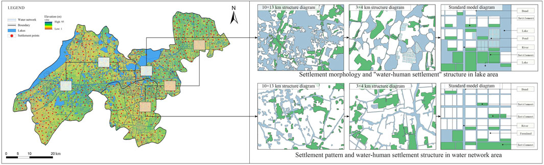
Figure 9. Water network environment. (Image source: drawn by the author).
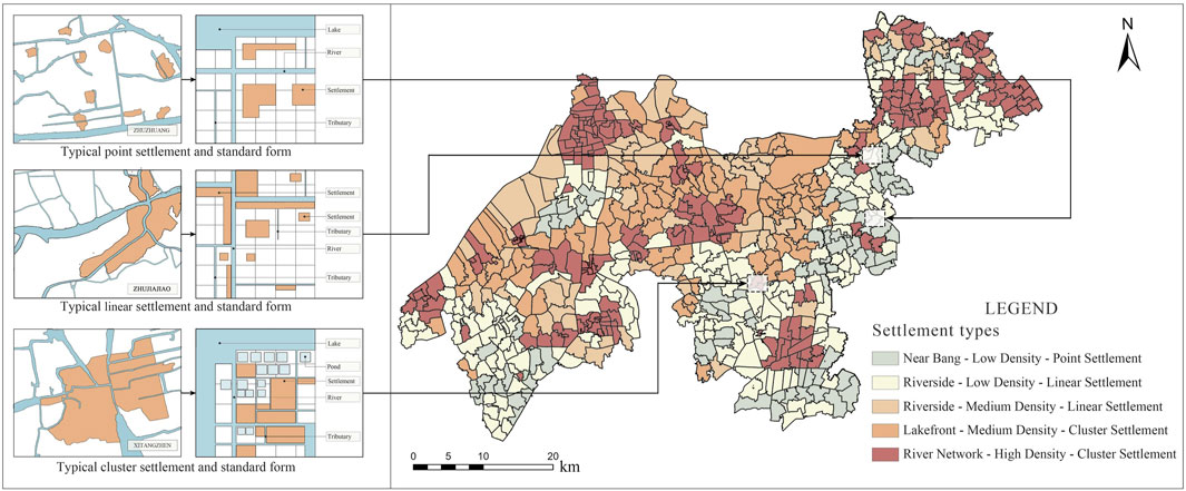
Figure 10. Distribution of settlement types. (Image source: drawn by the author).
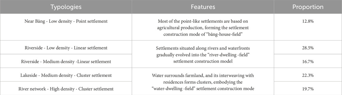
Table 3. Spatial types of settlements in the EGIDZ.
In addition, the study analyzed the structure of sample settlements using satellite imagery and field data. This approach clearly reveals the texture characteristics of “water-field-dwelling” settlements.
3.3 Structural features
Through the analysis of clustering results, we can gain a more in-depth understanding of the settlement space categories in the EGIDZ. Thereby it is possible to achieve a thorough understanding of the settlement spatial characteristics within the region. The study used identification and spatial morphological typology to extract structural characteristics from various types of settlements in EGIDZ. These methods also constructed a standardized the spatial pattern to summarize the adaptive development status of each type (Figure 11).
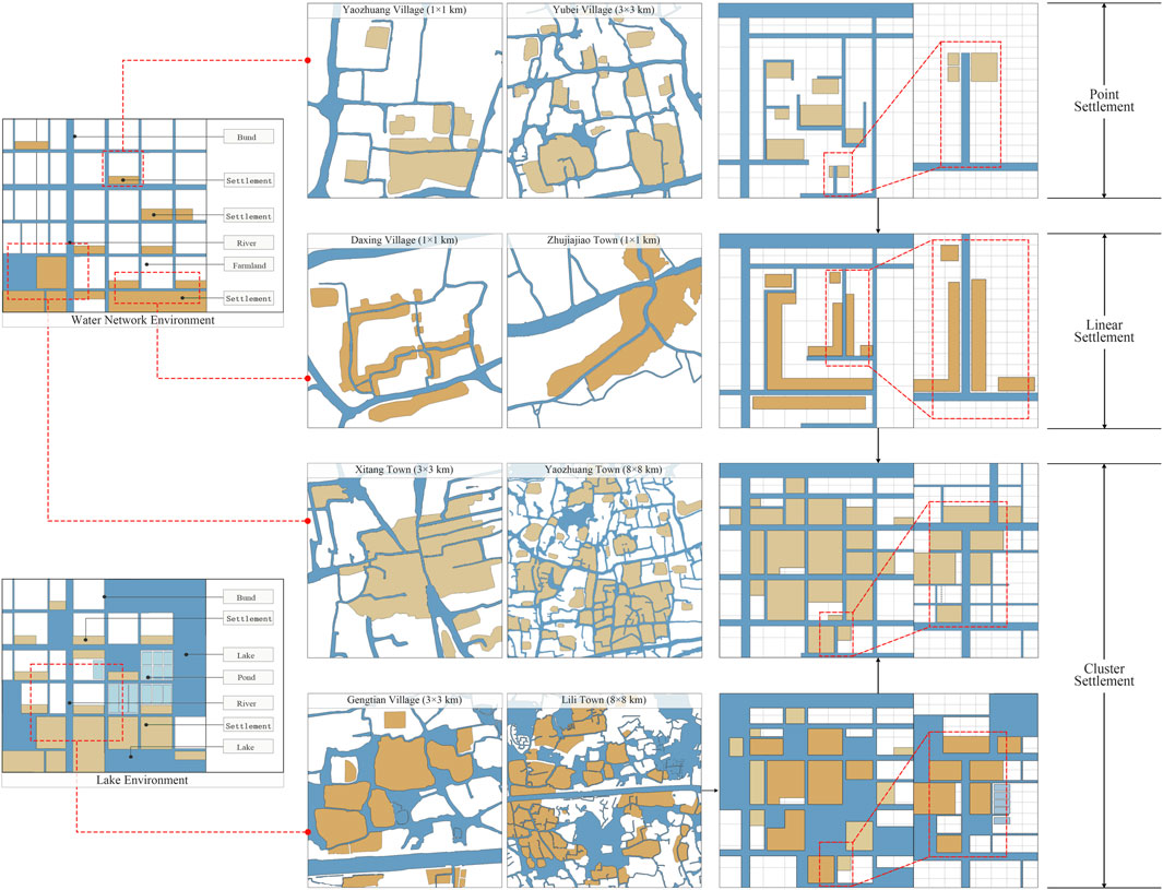
Figure 11. Spatial structure characteristics of settlements. (Image source: drawn by the author).
3.3.1 Point settlement: Near Bāng - Low density–Point settlement
The point settlements are mostly scattered around the river outside of the town. In the eastern part of Taihu Lake, “bāng (浜)” originally refers to a small river with a second separated riverbed, usually at the end of a water system. Gradually developing, “Jing (泾)” (mostly small man-made rivers) and “bāng” formed irregular and curved water systems (Wang, 2009). Due to the small population scale, most of the point-like settlements are based on agricultural production, forming the settlement construction mode of “bāng-house-field”.
In EGIDZ, the Near Bāng-Low density-Point settlements are mostly distributed in Qingpu area of Shanghai and Jiashan region of Jiaxing. This type of settlement is small in scale and its spatial distribution factors are point-like. In addition, the traffic network density is low, and the settlements are scattered in the periphery of the city. There is no significant agglomeration trend. Affected by man-made canals and relatively low urbanization level, the overall land use structure of the settlements is mainly farmland. It shows the characteristics of farmland parcel and Jing-Bāng interlace. It is worth mentioning that point-like settlements tend to develop in all directions over time, gradually forming lines or clusters.
3.3.2 Linear settlement: Riverside - Low/medium density – Linear settlement
The formation of Linear Settlements is closely related to river morphology. About 80% of the settlements in Jiangnan Water Village are built along the river (Sun et al., 2024). The settlement patterns and polder layout often show linear structures along the water system. After the small plots were occupied, the settlements close to the water body expanded linearly along both sides of the river. Thus, they formed a band-like agglomeration pattern. Due to the needs of agricultural production, the distribution characteristics of settlements located by the waterfronts gradually developed into the “river-dwelling-field” settlement construction model.
The Riverside-Low density-Linear settlements are mostly distributed in the central periphery of EGIDZ. The spatial distribution factors tend to converge towards areas of dense river networks. The boundary shape is relatively simple, the road network and building combination pattern also show a linear development state. In addition, with the rapid urbanization, the linear settlements are not only distributed along the river, but also toward the road. This leads to the formation of a multi-level linear extension of the rural space.
The Riverside-Medium density-Linear settlements are mostly developed from low-density settlements, distributed along the river. There is a trend of getting closer to the urban center, and form a larger scale settlement center. Due to its relatively developed economic level and high urbanization rate, all factors such as the settlement boundary shape, land use structure, road network and building combination model shows a high level.
3.3.3 Cluster settlement: Lakeside - Medium density – Cluster settlement; river network - High density - Cluster settlement
The cluster settlements are mainly distributed by the large and small lakes and next to the places of the confluence of rivers. Since the water area is quite large, agriculture and shipping are developed. The economic level is relatively high and the settlements are clustered in units. The eastern part of Taihu Lake was initially a swamp. Throughout the dynasties, people employed water conservation projects, dug rivers and canals to drain silt, and enclosed lakes for reclamation. Over time, intersecting rivers, ports, streams, and creeks formed an extensive waterway system, with addition of scattered lakes and swamps (Fan, 1986). People gather and settle in the intersection of river and lake network, so the water surrounds farmland and human settlements. The settlements form a unit, creating the “water-dwelling-field” settlement construction model.
Lakeside - Medium density - Cluster settlements in EGIDZ are mainly distributed in the central and western regions. Lakes densely cover the area (such as Dianshan Lake, Fen Lake, etc.), water surrounds the settlements, the river passes through the village. The complex water environment promotes the scattering of the settlement centers along the lake shore. The shape of the settlement boundary has a complex form. Cultivable land resources are quite limited. However, numerous fish ponds create a distinct “lake - fish pond - polder - village” land use structure. The road network and building densities remain relatively low. Although the lakes initially shaped the settlement units, the complex water network limited their expansion, resulting in a moderate overall density.
River network - High density - Cluster settlements usually form a large-scale settlement center at the intersection of rivers and develop a certain level of infrastructure (agriculture, tourism, etc.). An active spatial distribution pattern emerged as settlements gradually diverged. Their expansion followed the paths of rivers, lakes, and roads. Rivers intertwine with settlements, creating a complex land use structure where water system and human settlements interact. The settlement network shows an obvious centralization and units layout. Under the influence of economic development and related policies, cluster settlements tend to leverage river network resources to spread outward. This expansion will result in transforming them into larger agglomeration centers.
In general, due to the diverse forms of water systems, there are obvious differences in among different settlement types and their spatial structures. However, they all share the spatial features of Jiangnan water towns. The settlements form a landscape sequence of “water-polder-dwelling-mountain” with elements such as rivers, lakes, streets, dwellings, and fields. This common feature reflects the adaptation of settlements to the local natural environment and embodies the unique spatial logic of integrating nature and human-made spaces in the region.
4 Discussion
4.1 The evolution of settlement space amid the dynamic development of water systems
In-depth development of ecological integration in the Yangtze River Delta allows to establish the theoretical unity of “water system - human settlement” in the Jiangnan region. It contributes to the creation of a new style of Jiangnan water towns that meets the needs of time. Shaoyan Fan elaborated the three basic stages: the emergence, growth, and maturity of settlements in China (Fan, 1994). He also described two evolutionary forms - concentration and dispersion - laying the theoretical foundation for the spatial structure of human settlements in China. Through the scientific analysis above, we defined the “water system-human settlement” relationships in the EGIDZ. Settlements are close to waterfronts of rivers and lakes and surrounded by an interwoven river network. There are settlement categories of point, linear, and cluster shapes. Tracking spatial patterns and comparing structural elements - buildings, roads, water networks, and land use - across settlements reveals the evolutionary laws and agglomeration behind the settlements spatial morphology of EGIDZ (Figure 12).
1. Spatial form development from point to cluster. Water town settlements adhere strictly to the path of the natural landscape. Their layout appears as a point-like structure, scattered across the water network plain. Such point-like settlements tend to grow with the development of human activities. Over time, it forms linear or cluster shapes. Point-like settlements, often centered at river confluences, step by step expand along both sides of the water. This process, guided by the water system, forms an overall linear development. The settlement has an opportunity to eventually evolve into large cluster-like agglomeration.
2. Cluster spatial pattern from low to high density. Initially, people formed low-density point-like settlements mainly at the ends of river creeks. River creeks provide various essential conditions for human survival, such as water sources, transportation, and agricultural irrigation. With the formation of settlements and the growth of population, especially at the intersections of water ways, the convenience of transportation enabled settlements to develop into high-density economic and cultural centers.
3. Spatial structure evolution from river-oriented to road-oriented. In the era of water transport, the settlement space growing along riversides determined the parallel spatial structure of “river-street-house” in water town settlements. With the rapid development of urbanization, thoroughfares became an important factor in the spatial evolution of settlement forms, street organization, and residential courtyards. In addition to the linear distribution along rivers, the master plans of settlements developed towards roads. The settlement space expanded on multiple levels. This transition indicates the adaptation of human settlements to the water system. Moreover, it is clear that the transportation accessibility has the driving role in promoting agglomeration growth and functional upgrading.
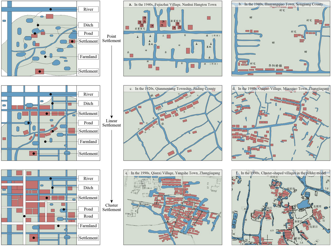
Figure 12. The dynamic evolution of settlement space in water towns and representative cases. (Image source: author redrew based on historical documents, surveying and mapping data and other materials.) (a) Based on the Compilation of the Genealogy of the Fu Family Branches in Hangtou, Pudong, Shanghai compiled in 2010, the Map at the Beginning of the Volume was redrawn; (b) Redrawn based on the illustration on page 150 of Huang Zongzhi’s Small Peasant Families and Rural Development in the Yangtze River Delta in 2000, Zhonghua Book Company; (c) Based on the Continuation Annals of Jiading County of the Republic of China era, the Map of Qianmen Tang Township at the top of the table and the caption was redrawn; (d) Redrawn based on the 148-page illustration in (Li, 2007) book Rural Settlements: Form, Type and Evolution: A Case Study of the Jiangnan Region, Southeast University Press; (e) Based on the 164-page illustration in (Li, 2007) book Rural Settlements: Form, Type and Evolution: A Case Study of the Jiangnan Region, Southeast University Press; (f) Redrawn based on the 43-page illustration in (Li, 2007) book Rural Settlements: Form, Type and Evolution: A Case Study of the Jiangnan Region, Southeast University Press.
4.2 The influencing mechanism of the spatio-temporal evolution of water town settlements
Water resources not only serve as the foundation for human survival but also underpin diverse human activities and agricultural processes, making significant contributions to both the natural environment and human wellbeing (Liu et al., 2024). The settlement pattern of Jiangnan water towns results from a combination of natural, agricultural, and economic factors. Nature provides the terrain and water systems, agriculture shapes land use, and water transportation drives the economy. Together, they create an orderly pattern characterized by openness, diversity, complexity, and sustainability. The evolution of water systems provides the main reference point for the spatiotemporal process of traditional settlement development in water town areas. This process reveals the influence mechanism behind Jiangnan settlement spatial evolution (Figure 13). This mechanism reflects the long-term interaction between human activities and the natural environment. It also provides a historical perspective for understanding current settlement patterns and predicting future development trends.
1. The water system environment determines the basic form and distribution pattern of human settlement spaces. Settlements and riversides are inseparably linked. Rivers are directly related to the construction of settlements and people’s daily lives. It evolves into a settlement environment and spatial form characterized by “villages depending on creeks (浜村相依)”. The unique feature of Jiangnan water towns is their riverside existence. Settlements live directly alongside the water, set up markets and form streets on its banks. This layout creates a structure ideal for both water and land transportation.
2. Human activities drive the dynamic development of settlement spatial structures. The types and characteristics of settlement spaces in the Jiangnan region are shaped by a combination of social, economic, and political factors. Human demands for living environments, agricultural production, transportation, trade, and cultural activities drive the evolution and development of settlement spaces. Exploring the causal mechanisms behind Jiangnan water town spatial formations makes the ecological development more sustainable. This process requires a thorough consideration of complex “nature-society-culture” factors.
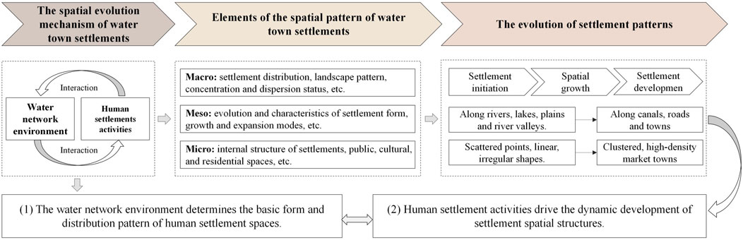
Figure 13. Influencing factors of the spatial evolution of settlements.
5 Conclusion
5.1 Research findings
Focusing on the “water systems - human settlements” interaction, this paper analyzes multi-scale settlement space typologies and structural characteristics in the EGIDZ. Geographic information technology, remote sensing images, historical documents, and survey data together enable a schematic analysis of each settlement typologies and its structural characteristics. The following are the main findings of this study. 1) The settlement space in the EGIDZ generally presents a distribution pattern of “large dispersion and small units” and shows a tendency to spread outward with towns as the center. 2) The differences in water system forms determine the basic spatial types of settlement spaces (point, linear and cluster) and the structural characteristics of “water-field-dwelling”. Specifically, they are divided into five categories: Near Bāng - Low density - Point settlement, Riverside - Low density–Linear settlement, Riverside - Medium density–Linear settlement, Lakeside - Medium density - Cluster settlement, River network - High density - Cluster settlement. 3) The water system environment is closely related to the settlement space. Different settlement forms response to the water system environment in the region. The water system environment determines the spatial distribution and basic morphological characteristics of settlements. At the same time, human activity factors such as agricultural production and infrastructure construction promote the evolution and development of the settlement spatial structure.
The research framework of “water system-human settlement” interconnection serves as a basis for an in-depth exploration of the spatial characteristics and evolution laws of settlements in the EGIDZ. It provides important insights and references for the protection policies and landscape construction methods in the “New Jiangnan Water Towns”. (1) The spatiotemporal evolution of settlements in the EGIDZ under the “water system-human settlement” coupling reveals a critical insight: China’s policies of urban-rural integration and the integration of the Yangtze River Delta should be implemented in coexistence with the natural environment. In particular, building an adaptive ecological coupling system enhances the ecosystem service efficiency of mountains, water, forests, and lakes. This process is vital for maintaining the ecological balance of water town settlement spaces. (2) Although there are obvious differences in characteristics among different settlement types and their spatial structures, they all share the common features of Jiangnan water towns. Therefore, in the practice of modern rural planning and urban renewal, it is necessary to respect the principle of the “water-polder-dwelling-mountain” landscape pattern in Jiangnan. (3) Human settlement space is the most precious cultural and material wealth of Jiangnan water towns. In the protection policies of historical towns, it is crucial to pay attention to the correlation between the traditional human settlements and other environmental elements. Architectural heritage protection must adapt to local conditions. An effective approach builds a protection path through ecological governance, spatial optimization, industrial development, and cultural inheritance.
5.2 Limitations and future directions
The “water system-human settlement” coupling morphology in this study provides a reference for the research on the sustainable development of water town settlement spaces. However, there are still some limitations. Firstly, the comprehensive method combining geographic information, historical documents, and field surveys may have deviations in data collection. Second, landscape pattern indices reveal interactions between water systems and human settlements while identifying spatial morphology. Nevertheless, complex theoretical research on the dynamic factors behind morphological changes remains underdeveloped. Furthermore, systematic research on “water system-human settlement” coupling requires more interdisciplinary technologies. Integrating cutting-edge GIS analysis with machine learning can provide a more detailed understanding of the interaction between the natural environment and human settlements.
Finally, subsequent studies should adopt more comprehensive perspectives from architecture, geography, ecology, and history. These investigations must also account for the unique regional characteristics of Jiangnan to systematically explore water town settlements. The implementation of rural revitalization and urban-rural integration policies provides a foundation for examining the “water system-human settlement” coupling structure and its underlying causal mechanisms. Comprehensive planning should formulate targeted, interactive construction strategies. These strategies should adapt to the trend of the Yangtze River Delta integration under the conditions of rapid urbanization.
Data availability statement
The original contributions presented in the study are included in the article/supplementary material, further inquiries can be directed to the corresponding author.
Author contributions
ZY: Writing – original draft, Formal Analysis, Project administration, Visualization, Data curation, Resources, Validation, Conceptualization, Methodology, Supervision, Writing – review and editing, Funding acquisition, Investigation, Software. HW: Resources, Project administration, Validation, Methodology, Writing – review and editing, Supervision, Conceptualization, Funding acquisition. AK: Formal Analysis, Writing – review and editing.
Funding
The author(s) declare that financial support was received for the research and/or publication of this article. The following funding sources support this research: the Project of National Social Science Fund of China (Art Science). Research on the Mutual Adaptation Mechanism and Transformation of the “Water Town Environmental System” and “Traditional Human Settlements” in Jiangnan (grant number: 23BG141).
Conflict of interest
The authors declare that the research was conducted in the absence of any commercial or financial relationships that could be construed as a potential conflict of interest.
Generative AI statement
The author(s) declare that no Generative AI was used in the creation of this manuscript.
Any alternative text (alt text) provided alongside figures in this article has been generated by Frontiers with the support of artificial intelligence and reasonable efforts have been made to ensure accuracy, including review by the authors wherever possible. If you identify any issues, please contact us.
Publisher’s note
All claims expressed in this article are solely those of the authors and do not necessarily represent those of their affiliated organizations, or those of the publisher, the editors and the reviewers. Any product that may be evaluated in this article, or claim that may be made by its manufacturer, is not guaranteed or endorsed by the publisher.
References
Bi, S., Du, J., Tian, Z., and Zhang, Y. (2024). Investigating the spatial distribution mechanisms of traditional villages from the human geography region: a case study of Jiangnan, China. Ecol. Inf. 81, 102649. doi:10.1016/j.ecoinf.2024.102649
Cai, W., Shu, C., and Zhu, Y. (2023). Using ecosystem services to inform sustainable waterfront area Management: a case study in the Yangtze River Delta ecological green integration Demonstration zone. Land 12 (7), 1351. doi:10.3390/land12071351
Cai, H., Yu, J., and Guo, Y. (2025). Spatial and temporal distribution and evolution of traditional villages in Xin'an River Basin of China based on geographic detection and remote sensing technology. Ecol. Indic. 171, 113239. doi:10.1016/j.ecolind.2025.113239
Chen, D., Yang, J., and Shi, Y. (2022). Study on the construction of spatial Genealogy of village and town settlements based on spatial Genes. Chin. Landsc. Archit. 38 (12), 115–120. doi:10.19775/j.cla.2022.12.0115
Chen, W., Yang, L., Wu, J., Wu, J., Wang, G., Bian, J., et al. (2023). Spatio-temporal characteristics and influencing factors of traditional villages in the Yangtze River Basin: a Geodetector model. Herit. Sci. 11 (1), 111. doi:10.1186/s40494-023-00948-x
Chinese Academy of Agricultural Sciences (1990). A history of agriculture in the Taihu Lake area. Beijing: Agricultural Press.
Ding, W. (2015). “2012 Jiangsu rural survey: Changzhou Chapter,” in Jiangsu provincial Department of housing and urban-rural development. Beijing: The Commercial Press.
Duan, J. (2015). “2012 Jiangsu rural survey,” in Jiangsu provincial Department of housing and urban-rural development (Beijing: The Commercial Press).
Duan, J., and Ji, S. (2002). Analysis of urban space: spatial structure and form of ancient towns in the Taihu Lake Basin. Beijing: China Architecture and Building Press.
Fan, C. (1986). Records of Wujun (Collated by Lu, Z.). Nanjing: Jiangsu Ancient Books Publishing House.
Fan, S. (1994). Evolution mechanism of rural settlement spatial structure. J. Northwest Univ. Nat. Sci. Ed. (4), 295–298+304. Available online at: https://xdxbzk.nwu.edu.cn/thesisDetails?columnId=9589700&Fpath=home&index=0&lang=zh.
Guo, W. (2025). Taihu plain polder residential system research. Riv-habitats Research Center. Available online at: https://mp.weixin.qq.com/s/uHptiJeJ0Jw0DcuUm0KRsA.
Hamashima, A. (1990). Some investigations on “Wei” in Jiangnan. Hist. Geogr. (1), 188–200. Available online at: https://qikan.cqvip.com/Qikan/Article/Detail?id=7103853444&from=Qikan_Search_Index.
Hu, W., Wang, G., and Deng, W. (2008). Research progress on the relationship between landscape pattern and ecological processes. Prog. Geogr. (1), 18–24. doi:10.11820/dlkxjz.2008.01.003
Huang, Y., Xia, J., Chen, Y., and Hong, J. (2024). Global research progress on rural settlement spatial patterns from 2000–2024: a comprehensive review of hotspots, frontiers, and emerging trends. Front. Earth Sci. 12, 1505570. doi:10.3389/feart.2024.1505570
Huang, Y., Huang, Y., Chen, Y., Yu, Y., Zheng, L., and Ying, Z. (2025a). Interpretation of the Jiangnan landscape and countryside (Shan-shui) pattern: evidence from the classification and spatial form of traditional settlements in the Nanxi River basin. Buildings 15 (3), 413. doi:10.3390/buildings15030413
Huang, Y., Huang, Y., Chen, Y., Song, J., Yang, S., Huang, L., et al. (2025b). The evolution and construction of Shan-shui cities: evidence from the ancient city of Hangzhou from the sixth to the twenty-first century via geographical information systems and space syntax. Front. Earth Sci. 13, 1551117. doi:10.3389/feart.2025.1551117
Huang, Y., Huang, Y., Chen, Y., and Yang, S. (2025c). Spatial evolution of traditional waterside settlements south of the Yangtze River and the distribution of settlement heritage: evidence from the Nanxi River Basin. npj Herit. Sci. 13 (1), 62. doi:10.1038/s40494-025-01649-3
Huang, Y., Shi, Z., Chen, Y., Zhou, K., Ying, Z., Zheng, L., et al. (2025d). Urban form evolution and transformation of traditional water towns based on space syntax and GIS: evidence from ancient Wenzhou city (16th to the 20th century). Front. Earth Sci. 13, 1520643. doi:10.3389/feart.2025.1520643
Huang, Y., Chen, Y., and Hong, J. (2025e). Regional spatiotemporal evolution and influencing factors of rural construction areas in the Nanxi River Basin via GIS. Open Geosci. 17 (1), 20250801. doi:10.1515/geo-2025-0801
Ji, S., Duan, J., Xue, S., Li, L., and Gong, Z. (2023). Exploration of urban Design methods based on spatial Gene inheritance: a case study of the water town living Room in the Yangtze River Delta integration Demonstration zone. City Plan. Rev. 47 (12), 4–12+48. doi:10.11819/cpr20231202a
Jiang, B., Huang, Y., Chen, Y., Lu, J., and Yang, T. (2025). The distribution pattern and spatial morphological characteristics of Military settlements along the ming great Wall in the Hexi Corridor region. Buildings 15 (7), 1136. doi:10.3390/buildings15071136
Jin, Q. (1982). A study on rural settlement geography: a case study of Jiangsu province. Geogr. Res. 1 (3), 11–20. doi:10.11821/yj1982030002
Li, L. (2007). Rural settlements: form, type and evolution: a case study of the Jiangnan region. Nanjing: Southeast University Press.
Li, J., and Song, W. (2023). Review of rural settlement research based on bibliometric analysis. Front. Environ. Sci. 10, 1089438. doi:10.3389/fenvs.2022.1089438
Liu, B. (2015). Methodology and application of human settlements research. Beijing: China Architecture and Building Press.
Liu, H., Xing, L., Wang, C., and Zhang, H. (2022a). Sustainability assessment of coupled human and natural systems from the perspective of the supply and demand of ecosystem services. Front. Earth Sci. 10, 1025787. doi:10.3389/feart.2022.1025787
Liu, X., Li, Y., Wu, Y., and Li, C. (2022b). The spatial Pedigree in traditional villages under the perspective of urban Regeneration—taking 728 villages in Jiangnan region, China as cases. Land 11 (9), 1561. doi:10.3390/land11091561
Liu, J., Pei, X., Zhu, W., and Jiao, J. (2024). Water-related ecosystem services interactions and their natural-human activity drivers: Implications for ecological protection and restoration. J. Environ. Manag. 352, 120101. doi:10.1016/j.jenvman.2024.120101
Liu, H., Lu, J., Li, X., Wang, Y., Xu, D., Yin, J., et al. (2025). Evaluating human-nature relationships at a grid scale in China, 2000–2020. Habitat Int. 156, 103282. doi:10.1016/j.habitatint.2024.103282
Morris, A. E. J., Cheng, Y., and Lu, F. (2018). A history of urban form: before the industrial Revolution. World Archit. (5), 115. doi:10.16414/j.wa.2018.05.058
National Bureau (2024). National Bureau of statistics. Available online at: https://www.stats.gov.cn/xxgk/sjfb/zxfb2020/202412/t20241223_1957823.html.
Ruan, Y., and Yuan, F. (2016). From Guardianship to inheritance: 30 Years of protection practice for ancient water towns in the Jiangnan region. China Anc. City (7), 4–7. Available online at: https://kns.cnki.net/kcms2/article/abstract?v=d7HKHDfP4kcRJ1O38lV-owbuzdUKHiZX7-k2EjV5IG-4YO7UBwrbhIEc7ngQa5k88y0DslbkRXs75G3naraFJZLwB8xoC2vqKmxAdRNgbFCg0OL-04ps21r44fJVnWY_3g0Hu6S_lAtQJ7pHVD1QzV8fFwxtuB_Kyk-4hFsrLsBR8rPM5O9OhA==&uniplatform=NZKPT&language=CHS.
Shi, X., Wu, D., and Guo, W. (2022). Layout pattern of “water-field-village” under the landscape pattern of polder-duo fields. Landsc. Archit. 29 (2), 53–58. doi:10.14085/j.fjyl.2022.02.0053.06
Sun, J., Wang, Q., and Guo, W. (2024). Causes and characteristics of traditional human settlement system of (㘰)-Polder fields in Xitiaoxi Watershed. Landsc. Archit. 31 (1), 64–70. doi:10.3724/j.fjyl.202306080266
Urban-Rural Development(2016). “Ministry of housing and urban-rural development of the people's Republic of China,” in Analysis and inheritance of Chinese traditional architecture: Jiangsu Volume(Beijing: China Architecture and Building Press).
Wang, J. (2009). The development of jing and Bang and the polder water Conservancy in the Wusong River basin (9th-15th Centuries). J. Chin. Hist. Geogr. 24 (2), 30–42. Available online at: https://kns.cnki.net/kcms2/article/abstract?v=d7HKHDfP4kcVs6EOnYaQ4fGHYcaXl43QCN7EWwykHByiUllLvgplu6bVsB0VmhXykEqSp5Lu3Myz8_QUumr3oCmywk6IiP755njJXz6XzwQgkBKQCukujAtq0rsnbjfGy4JkfWUDF4iAy7_ffHtFWXoEBMQzkPxRRdlINUQpH-y9n48B5FqONg==&uniplatform=NZKPT&language=CHS.
Wang, Y. (2025). From fragments to system: a research on the mesoscale structure of vernacular landscapes in the Hang-Jia-Hu area, China. J. Asian Archit. Build. Eng. 24 (4), 2191–2210. doi:10.1080/13467581.2024.2358209
Wang, H., Pu, X., Wang, R., Zeng, Y., and Qi, X. (2016). A study on closed halls in traditional dwellings in the Jiangnan Area, China. J. Asian Archit. Build. Eng. 15 (2), 139–146. doi:10.3130/jaabe.15.139
Wang, H., Zhou, R., Yang, Z., Chen, Y., and Bin, H. (2024). The "environment-human settlement" form and its causes of traditional settlements in the coastal area of southern Yangtze river under the influence of tides. New Architecture 24 (2), 46–52. doi:10.12069/j.na.202311402
Wei, Q. (2023). Zhejiang settlements (series on protection of Chinese traditional settlements). Beijing: China Architecture and Building Press.
Wei, J., Ni, Y., Shou, T., and Zhang, Y. (2023). Study on the construction of ecological security pattern based on water-land coupled ecosystem services: a case study of the Yangtze River Delta ecological and green integrated development Demonstration zone. Acta Ecol. Sin. 43 (13), 5305–5319. doi:10.5846/stxb202105071202
Wu, L. (2014). A history of Chinese human settlements. Beijing: China Architecture and Building Press.
Wu, J. (2016a). The differentiation of settlement forms and driving mechanisms in the eastern plain of Taihu Lake since the Song and Yuan dynasties. J. Chin. Hist. Geogr. 31 (2), 14–26. Available online at: https://kns.cnki.net/kcms2/article/abstract?v=d7HKHDfP4kcI1L6QLHkTbjD66GbqukQcyYvM8IvSMnsHWJkaPAp_rWJFrp0Ib4T_DvLwJMzvwebYSSsxR2c610CmXt1O63QYNsb_kWlE2WkeOBZ5wS2cy0quYc4iLvuIKayajgp3pG4PBwBRUqs4Ixo7q-sJ__x53-E6YS3jKyAMlDWE2ysoSg==&uniplatform=NZKPT&language=CHS.
Wu, J. (2016b). Water town settlements: a study on the ecological history of Homesteads east of Taihu Lake. Shanghai: Shanghai Classics Publishing House.
Zhang, M., and Zhai, J. (2021). Development model of “new Jiangnan water towns” based on landscape infrastructure: a case study of the Yangtze River Delta ecological and green integrated development Demonstration zone. Chin. Landsc. Archit. 37 (8), 115–120. doi:10.19775/j.cla.2021.08.0115
Zhang, R., and Zhang, X. (2022). Distribution characteristics and influencing factors of rural settlements in Metropolitan Fringe area: a case study of Nanjing, China. Land 11 (11), 1989. doi:10.3390/land11111989
Zhang, Y., Tian, Z., Du, J., and Bi, S. (2024). Multidimensional evaluation of traditional villages in Jiangnan region, China: spatial pattern, accessibility and driving factors. Buildings 14 (3), 823. doi:10.3390/buildings14030823
Zhao, Y., and Wang, J. (2018). Study on traditional rural settlement planning based on morphological Integrity: application of Performance-oriented Improvement planning technology for settlements. City Plan. Rev. 42 (11), 33–40+53. doi:10.11819/cpr20181105a
Zhong, Q., Xie, L., and Wu, J. (2025). Reimagining heritage villages' sustainability: machine learning-driven human settlement suitability in Hunan. Humanit. Soc. Sci. Commun. 12 (1), 661–19. doi:10.1057/s41599-025-04971-0
Zhou, Q., and Guo, W. (2024). Study on the morphological type system of traditional settlements in Pudong guided by Hydrology. Urban Environ. Des. (1), 252–258. Available online at: https://kns.cnki.net/kcms2/article/abstract?v=d7HKHDfP4keDm5-zX52rBe486rDTixLamCvQj0E1AkSoi91YgSvYEYai2QWAGen_nHToTRbJ3qoOnopoTC4KvgmBX2So_EErSkUi3Hsks2Q31isHMDQ8JYX1IukVcFNIDAVC7DO0qPJxEdsRX4dLR4Pxuq2JVbaHyuEmkxp4T7DcjaP6EZTHHg==&uniplatform=NZKPT&language=CHS.
Zhou, M., He, Y., Chen, Y., and Pu, X. (2024). Study on spatial form and formation mechanism of rural settlements in Xiaoshan area, Zhejiang province under the influence of water systems. Modern Urban Res. 24 (04), 42–49. doi:10.3969/j.issn.1009-6000.2024.04.007
Keywords: Jiangnan water towns, human settlements, typologies and characteristics, waternetwork environment, Yangtze River Delta
Citation: Yang Z, Wang H and Kharchenko A (2025) Spatial typologies and structural characteristics of Jiangnan water town settlements: a “water system–human settlement” perspective. Front. Earth Sci. 13:1652780. doi: 10.3389/feart.2025.1652780
Received: 24 June 2025; Accepted: 03 September 2025;
Published: 25 September 2025.
Edited by:
Haimeng Liu, Chinese Academy of Sciences (CAS), ChinaReviewed by:
Christopher Okech, Moi University, KenyaYuhao Huang, City University of Macau, Macao SAR, China
Copyright © 2025 Yang, Wang and Kharchenko. This is an open-access article distributed under the terms of the Creative Commons Attribution License (CC BY). The use, distribution or reproduction in other forums is permitted, provided the original author(s) and the copyright owner(s) are credited and that the original publication in this journal is cited, in accordance with accepted academic practice. No use, distribution or reproduction is permitted which does not comply with these terms.
*Correspondence: Haisong Wang, MzA2NzQ2OTExM0BxcS5jb20=