 Daniele Cifaldi
 Guido Leone
 Davide Mazza
 Paola Revellino
- Department of Sciences and Technologies, University of Sannio, Benevento, Italy
Monitoring activities are fundamental for properly assessing landslide dynamics and safety of infrastructures exposed to landslide risk. Considering the expense of professional instruments, building a dense sensor network to collect distributed data is often challenging. A low-cost Arduino©-based 3-axis inclinometer is presented here as an alternative and valuable solution for widespread monitoring on low-budget projects. This sensor was developed to perform structural health monitoring (SHM), and assess the damage level and its growth rate by measuring the angular rotations of structures. In particular, the device takes measurements along three directions (x, y and z-axes) in a full range of rotation and is characterized by very compact size and low power consumption. These characteristics represent major advantages compared to most professional inclinometers, which usually measure tilt angles along one or two directions in a range of less than 90°. The open-source Internet of Things (IoT) based instrument - equipped with capacitive 3D-MEMS technology (Micro Electro Mechanical Systems) and developed with an SPI (Serial Peripheral Interface) digital interface chip, an online data sending system and local data storage - finds applications in several environmental settings. Preliminary field tests were carried out in different landslide contexts, to evaluate the reliability and versatility of use of the device.
1 Introduction
Coupling slope and infrastructure monitoring is fundamental to assess how natural processes affect the safety of anthropogenic features, such as buildings, bridges, roads, railways (Scarpelli et al., 2024). In this context, structural health monitoring (SHM) is required to prevent the future failure and potential risks. Over the last years, several SHM systems have been installed on civil infrastructures (Konovalov et al., 2018; Warsi et al., 2019; Scuro et al., 2021). Nonetheless, the application of this technique is generally limited to high-budget projects, primarily due to the expense of professional equipment. For this reason, the development of innovative low-cost sensors has become more and more important in slope instability contexts (Benoit et al., 2015; Guerriero et al., 2017; Revellino et al., 2021; Ruzza et al., 2020; Guerriero et al., 2021; Zuliani et al., 2022; Fang et al., 2024; Pavanello et al., 2024; Cifaldi et al., 2025; Li et al., 2025). Several examples of cost-effective projects for SHM purposes can be found in the literature (Nguyen et al., 2015; Girolami et al., 2017; Zonzini et al., 2020; Villacorta et al., 2021; Caballero-Russi et al., 2022; Yang et al., 2023; Andò et al., 2024; Brito et al., 2025), comprehending sensors for the assessment of structural behaviour under dynamic and static conditions (Andò et al., 2023). In particular, inclinometers are widely used in SHM systems. An inclinometer determines the angular inclination with respect to the vertical axis, providing high-accuracy measurements (Pehlivan and Bayata, 2016; Wierzbicki et al., 2020; Bertagnoli et al., 2021; Komarizadehasl et al., 2022; Lozano et al., 2024).
Most professional inclinometers - also commercially known as “tiltmeters” or “clinometers” - are developed to measure rotations along two axes within a limited range of values. Moreover, it is also important to consider the high costs of these devices (from around 1,000 up to several thousand euros), especially in large structures monitoring projects, where chains of multiple sensors are often necessary.
We present an innovative low-cost and customizable inclinometer, which could be a valid compromise between environment adaptability, user friendliness and cost-efficiency. This device was designed for structural health monitoring on landslide-related structures by observing their deformation over time. The instrument’s architecture is based on a micro-electro-mechanical sensor (MEMS) composed of 3D digital acceleration units capable of measuring the full range of rotation on three axes. In this context, MEMS have made an important forward step in tilt monitoring environments, allowing the implementation of compact and cost-effective solutions. It is worth noting that several experiments involving the use of this innovative technology are available in the literature. Barile et al. (2017) developed a wireless sensors network equipped with MEMS sensors for detecting rockfall events and monitoring vibrations and inclination of protection barriers. Andò et al. (2018) presented an Arduino device consisting of MEMS-based sensors (MMA7361L accelerometers and CA61T-FAHH1G inclinometers) for monitoring buildings’ seismic response. Ruzza et al. (2020) developed and tested a low-cost multi-module inclinometer (LSM9DS0 MEMS IMU) for borehole inclination monitoring in landslide contexts, reporting the results of laboratory and field experimentations. Ragnoli et al. (2022) developed a rockfall and landslide monitoring system applied on Pantelleria island using low-cost hardware equipped with LIS3DH sensors. Komarizadehasl et al. (2022) proposed an innovative low-cost instrument developed using multiple MEMS MPU9250 units embedding gyroscopes, accelerometers and magnetometers, for inclination measurements. Yang et al. (2023) showed a testing method based on conical motions for MEMS inclinometers. Paganis et al. (2025) designed and developed a low-cost instrument based on a MEMS sensor (MPU6050) interfaced with a Raspberry Pi 3B + board for inclination and acceleration monitoring. Li et al. (2025) implemented an inter-quartile range methodology to enhance MEMS-based inclinometers’ accuracy by eliminating noisy data during signal acquisition.
The presented inclinometer consists of an architecture with highly customizable hardware and software interface for local data storage and an online sending system. The development of this instrument was performed to keep the costs as low as possible and overcome the central issue in large-scale monitoring activities, represented by the expense of professional instruments. The cost reductions, in combination with low-power request and compatibility with multiple sensor network configurations, can guarantee an impressive suitability for several monitoring contexts. In addition, only a basic knowledge of electronics and programming is required for developing and maintaining this kind of device, making this project worthy of attention. Table 1 compares the main specifications of the presented low-cost sensor to those of the main professional devices.
This sensor was tested in the field in different environmental conditions to assess the versatility and reliability of the device. For this purpose, two locations situated in southern Italy were chosen for preliminary medium-term tests.
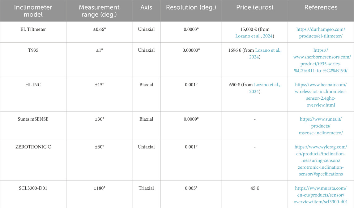
Table 1. Technical comparison between the low-cost inclinometer sensor (SCL330-D01) and some of the commercially available devices.
2 Materials and methods
2.1 Hardware section
The overall hardware structure of the device can be schematized in the following main components: (a) sensing unit consisting of an inclinometer sensor, (b) embedded data management system (acquisition, data storage and online transmission infrastructure, also housing the sensing unit), (c) power supply unit.
Waterproof plastic boxes were used to ensure long-term protection of the parts from weathering effects, in particular: the (a) and (b) components are housed into a 20 × 15 × 8 cm box and are bolted to an external metallic bracket; except for the solar panel, the (c) components are accommodated into a 30 × 22 × 14 cm box.
2.1.1 Sensing unit
SCL 3300-D01 by Murata is a triaxial inclinometer sensor designed for applications that require high reliability and accuracy, such as structural health monitoring, levelling, machine control and robotics. The sensor’s high performance allowed it to be used as a reference system for laboratory tests (Vacalebre et al., 2024a; Vacalebre et al., 2024b): showed the implementation of an SCL 3300-D01 unit for reference tilt measurements in a PCB-based inductive position sensors’ accuracy test. This sensor is based on capacitive 3D-MEMS technology and is developed with a Serial Peripheral Interface (SPI) chip. Usually, most professional inclinometers can measure tilt angles along one (monoaxial) or two directions (biaxial) in a limited range of inclinations (<90°), as shown in Table 1. On the other hand, the above described device can take measurements along three directions (x, y and z-axes) in a full range of rotation. It has low-power consumption and a wide temperature stability range (Supplementary Figure S1), making it suitable for harsh environments. It also offers four user-selectable operation modes that allow the setting of different inclination ranges. In our case, the full range of measurement (±180°) was set on the device to provide the optimal installation in every context.
The working principles of the sensor are based on the measurement of angles between the gravity vector and the instrument’s position. Four acceleration masses are housed in the inclinometer, and are free to change their position depending on the gravity vector’s orientation. The position of the masses results in specific electric voltage levels that can be converted in acceleration values. Then, the inclination can be obtained from acceleration by applying the following formulas (Equations 1–3):
where accx,y,z are acceleration values observed along each axis, while incx,y,z are inclinations along the three directions, expressed in decimal format. The inclinations, expressed in degrees, are derived as follows (Equation 4):
2.1.2 Embedded data management system
The components adopted for communicating with the sensing unit, local data storage and online transmission are housed - by connection pins or solder points - on a 10 × 10 cm electronic board (Supplementary Figure S2). A DS1307 Real Time Clock is installed to provide the device with the correct date and time. A micro SD card guarantees data local storage, while a SIM 800L GPRS GSM unit has the task of sending data via mobile connection by using a SIM card to a dedicated PHP web server All the components are managed by an Arduino Nano Every board; the combination of low-power drainage, high computing capacity and small size makes it a very suitable device for the project.
2.1.3 Power supply unit
The instrument can be powered directly from an electric network with a 12 V power supply or from solar energy. In our case, we used the solar energy, given the good sun exposure of the investigated sites. This power system (Supplementary Figure S3) consists of a 30 W photovoltaic panel and a 12 V, 20 Ah battery pack - composed of two 12 V 10 Ah batteries wired up in parallel - that are linked together to a 12 V, 10 A solar charge controller. Since the electronic board of the device cannot exceed a voltage of more than 7 V, a step-down DC-DC converter was installed. In addition, the FUTURA ELETTRONICA AL3005 power supply unit was involved in bench-testing the power absorption of the device under different load conditions. Tests showed a peak power consumption of approximately 0.14 A at 12 V that lasted for a few seconds, caused by the activation of the GSM unit during the online data-sending operation. Tests also showed a minimum continuous power consumption of approximately 0.05 A at 12 V for the rest of the time. The average power drain can be conservatively calculated as a mean of approximately 0.10 A, resulting in an average of 29 Wh daily electrical current request. Considering that annual average solar radiation is around 3 h per day in southern Italy (information obtained from the “ENEA Energia solare” website, URL: www.solaritaly.enea.it), the photovoltaic panel can produce around 90 Wh daily. This amount of electrical current is approximately 3 times the device power request, allowing the system to be fully charged even during cloudy days. The battery pack can provide approximately 8 days of autonomy in case of issues in the functioning of the solar panel. Extra panels or batteries could be added to the power unit if more capacity were required.
2.2 Software section
As discussed in a previous low-cost experiment by Cifaldi et al. (2025), the device was programmed using a dedicated free and open-source software named Arduino IDE (Integrated Development Environment). Arduino IDE is an advanced editor based on a language derived from C and C++ and optimised to write and upload programs for Arduino boards. This software, characterised by a user-friendly interface and constantly updated by a large support community, is designed to give complete access without advanced programming skills, encouraging the development of more innovative prototypes. The code lines of the program were specifically developed for the inclinometer, starting from the “SCL3300” program models - available by accessing the examples section of the IDE editor - and consulting several online public forums. In addition, the “GitHub” (https://github.com/) online platform for project repositories was also visited for programming problem-solving purposes. The program was designed to be easy to use by grouping all the fundamental setting parameters in a dedicated section.
3 Field tests
Two different cases were chosen for the preliminary filed tests of the low-cost inclinometer. Specifically, the measuring sites were located in Campania Region, in southern Italy, and the tested environments included indoor and outdoor installations, to evaluate the instrument’s medium-term reliability and versatility under multiple conditions.
3.1 Montaguto landslide case study
A first field test was performed in the area of the Montaguto landslide (Figure 1A). This landslide can be categorised as an earthflow, following the classification by Hungr et al. (2014), and has a total length of around 3 km, involving a volume of approximately 6 million m3 (Guerriero et al., 2013). The age of this mass movement has been estimated in about 100 years, and periodic reactivations have happened since 1946 (Guerriero et al., 2015). In terms of damages to the downslope linear infrastructures (national road and interregional railway), the two most important landslide reactivations took place in 2006 and 2010: the first one caused the closure of the SS90 state road; the second one caused damages to the national road again, and even to the Benevento-Foggia railway. Several mitigation measures were installed after the 2010 reactivation, consisting in a diffuse artificial drainage system and a rock-block wall at the landslide toe (Guerriero et al., 2018).
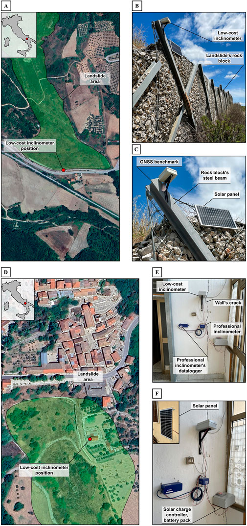
Figure 1. Global view of the Montaguto landslide toe (A); low-cost inclinometer’s installation details (B,C). Global view of Buonalbergo landslide source area (D); low-cost inclinometer’s installation details (E,F).
The low-cost inclinometer was installed in the upper part of the rock-block wall (Figures 1B,C; 41°14′15.51″ N; 15°13′15.82″ E) to monitor the structure deformation under the thrust applied by the landslide toe. The device’s software unit was set to record data with a 6-h sampling rate. The hardware frame was bolted on a rock block’s steel beam with an L-shaped metallic bracket. The device was oriented to have the x-axis in the direction of the landslide movement, the y-axis perpendicularly to it, and the z-axis in the vertical direction (Figure 2A). The precise levelling of the instrument is not important during the mounting process, thanks to the possibility of assuming the first data observed as a zero position and then calculating the tilt gaps over time. The field test started on 1 September 2023 and ended on 12 January 2024. The steel beam’s inclination data were compared with the beam’s top horizontal motion through multi-temporal Global Navigation Satellite System (GNSS) measurements (Figure 3), used as a reference system. This surveying technique was performed on a benchmark painted on the steel beam’s top (Figure 2B). A Topcon mobile station (Table 2) mounted on a 1.40-m-high stake was used. The procedure adopted is the same as described in a previous paper by Cifaldi et al. (2025). During the field test, 6 GNSS measurements were carried out: 1 September 2023, 2 October 2023, 19 October 2023, 24 November 2023, 15 December 2023, and 12 January 2024. The comparison between the two data sets was possible by obtaining the GNSS displacement components occurring on the horizontal plane, along the same axes observed by the inclinometer (named as GNSS x and y-components). The GNSS x-component is oriented along the landslide main movement direction, while the GNSS y-component is perpendicular to it (Figure 2B).
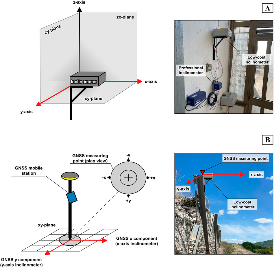
Figure 2. Low-cost inclinometer’s axes orientation (A); GNSS measuring point and x, y components orientation on the horizontal plane (B).
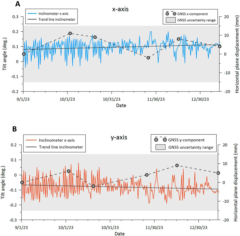
Figure 3. Low-cost inclinometer tilt angles and GNSS surveys data during the Montaguto landslide field test (A) Comparison between inclinometer’s x-axis and GNSS x-component readings. (B) Comparison between inclinometer’s y-axis and GNSS y-component readings.
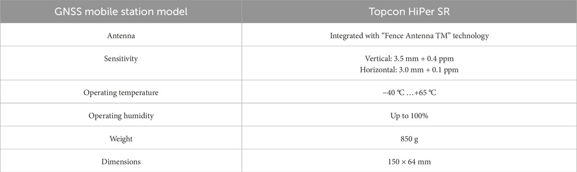
Table 2. Technical features of the GNSS receiver.
3.2 Buonalbergo landslide case study
The second field test site is the Buonalbergo landslide area (Figure 1D): it is considered a complex movement, involving a length of about 500 m. This landslide has moved during the last 30 years, causing severe damages to the main road and the nearby historic centre. A series of mitigation measures were adopted, such as pile bulkheads and drainage systems (Guerriero et al., 2021).
For this second test, the device was installed inside a house (41°13′11.63″ N; 14°58′50.15″ E), structurally compromised by the landslide dynamics (Figures 1E,F). The instrument was mounted by bolting an L-shaped metallic bracket on a wall. The wall shows signs of complex deformation and is affected by a wide sub-vertical crack. The device monitored the tilting of the wall over time (the axes orientation is shown in Figure 2A). The test started on 25 January 2025 and lasted until 30 May 2025. Data acquired in this monitoring period, were compared with those of a professional biaxial inclinometer (SIM STRUMENTI IN 921-MM; Table 3). The professional inclinometer was installed near the low-cost device, as shown by Figures 1E,F.
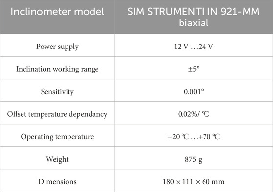
Table 3. Technical features of the professional inclinometer.
4 Data analysis
4.1 Montaguto landslide field test
Field test results from the Montaguto case study are represented in Figure 3. Low-cost inclinometer readings, performed on the steel beam of the landslide’s toe, were compared with GNSS horizontal displacements observed on the beam’s top measuring point (Figure 2B). The inclinometer data show a floating pattern whose range is around 0.2° for both axes. Except for the data fluctuations, no evident tilt angle variation was recorded from the beginning to the end of the test. This behaviour is also confirmed by GNSS readings, showing no effective steel beam’s top movement: in fact, the measured peak values are around 11 mm of motion for the GNSS x-component (Figure 3A) and around 9 mm for the GNSS y-component (Figure 3B). The observed displacement - smaller than the measurement accuracy of the mobile GNSS station (represented by a grey shading in the graphs of Figures 3A,B) - falls within the range considered as instrumental error and, for this reason, cannot be treated as effective linear displacement. Considering the sun exposure of the area and the limited changes in inclination observed, data floating could be caused by the steel beam’s thermal deformation. A thermal effect analysis was also carried out (Supplementary Figure S4) by comparing inclinometer data to hourly air temperature recorded at a nearby meteorological station. To this scope, a classic time series analysis approach was adopted (Leone et al., 2023; Leone et al., 2024). For the sake of simplicity, only the y-axis is shown. It can be seen how the “noisy” period of the inclinometer’s time series is associated with higher-frequency fluctuations in air temperature. Similarly, lower-frequency fluctuations in temperature cause slow changes in inclinometer measurements. However, the temperature-tilt relationship appears not linear.
4.2 Buonalbergo landslide field test
Figure 4 compares the monitoring time series acquired by the low-cost and professional inclinometers; tilt angles along the x and y-axis are shown. For an easier representation, both data sets start from zero to fit them on a standard scale, maintaining the original gaps between the values. Both devices were set to acquire four measurements per day (6-h sampling rate). However, we selected only the overnight readings for each day, to minimise the thermal effect on the wall-instrument infrastructure. Analysing in detail the inclination angles, it is possible to observe a common decreasing trend along the x-axis (Figure 4A), representing an inward tilting of the upper part of the wall during the test period (Figure 2A). On the other hand, an increasing trend was recorded along the y-axis (Figure 4B), indicating a lateral tilt of the wall (Figure 2A). Considering the fluctuation in the readings of the devices, the angular variations along the axes can be quantified using a representative method. For this purpose, time series were filtered by a linear trend. The angular variation is the difference between first and last datum taken on the trend line. Along the x-axis, variations of 0.14° and 0.05° were estimated for the low-cost and professional inclinometers, respectively. Along the y-axis, variations of 0.13° for the low-cost device and 0.04° for the professional one were estimated.
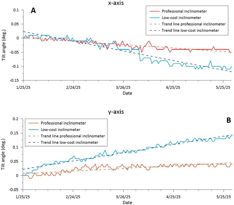
Figure 4. Low-cost and professional inclinometer tilt angles recorded during the Buonalbergo landslide field test (A) Device’s data correlation along the x-axis. (B) Device’s data correlation along the y-axis.
The gap shown between low-cost and professional instrument readings is limited (one-tenth of a degree difference). However, measurements seem to be affected by air temperature. Supplementary Figures S5A,C compares temperature and inclinometer data, revealing a possible temperature influence on measurements acquired by the professional sensor. Note that the inclinometer time series have been centred on the mean. The measurement gap between the two inclinometer sensors is associated with differences in the standard deviation of the time series. In Supplementary Figures S5B,D low-cost sensor measurements were adjusted by the standard deviation, highlighting similar temporal trends. The correlation between time series, particularly for the x-axis (Supplementary Figures S5A,B), is so evident that the two sensors practically measure the same signal. As such, a possible explanation for the measurement gap shown in Figure 4 lies in the mounting system. Specifically, the metallic bracket adopted is not the same as the professional one - L-shaped against the planar steel bracket - probably leading to a different deformation of the bracing architecture under certain thermal conditions (Ahmad et al., 2021).
5 Discussions and conclusions
This study discussed practical applications of a low-cost Arduino©-based 3-axis inclinometer, which offers a valid solution for widespread monitoring on low-budget projects. The device, equipped with a 3D-MEMS digital sensor, is capable of measuring the full range of rotation on three axes; this feature, in combination with the small size, low-power consumption and multiple user-selectable modes, makes this device very versatile, allowing it to be set in any orientation in space with minimal modifications to the mounting system. The high adaptability of the system’s software and hardware interfaces, combined with the factory calibration of the inclinometer sensor, provided a user-friendly environment, where a proper device’s implementation requires only basic knowledge of informatics and electronics. This aspect allows to avoid the necessity of specific training courses, unlike most professional instruments, which should be used by qualified people.
The low-cost inclinometer’s transmission system allows the configuration of networks of multiple devices by setting up the software interface to send data online to a common web server address. The synchronisation of the monitoring network can be easily obtained by configuring the same data uploading frequency for all the inclinometers.
However, poor mobile network coverage could be encountered in open field installations, especially in rural or densely forested areas, where other solutions could be necessary. A valid alternative is represented by devices equipped with Low Power Wide Area Network technologies (LPWAN) such as Sigfox© and LoRaWAN©. LoRaWAN (Long Range Wide Area Network) represents one of the most customizable, flexible and scalable radio communication protocols, capable of transmitting information up to 10 km in remote areas (https://edalab.it/lora-iot/) through LoRa signal modulation technology. This solution might allow the development of monitoring networks in areas lacking internet connection, by equipping all the instruments with LoRa electronic boards, responsible for sharing information via radio to the nearest gateway provided with a mobile connection. The gateway, consisting of a LoRa receiver and a router with a SIM card, would collect all the data packages coming from each instrument of the monitoring network and send them to a web server via internet connection.
The results from the first field test (Montaguto landslide) revealed that the low-cost inclinometer detected no significant angle variation. The absence of deformation assessed by the inclinometer is confirmed by GNSS measurements. The 6-h inclinometer time series shows daily fluctuations, probably attributable to the thermal deformation of the metallic structure monitored. The thermal effect is evident from the visual time series analysis. This last aspect could represent an interesting topic for further field tests by exploiting a combination of professional inclinometers and thermal probes (Ahmad et al., 2025) as reference systems for the low-cost device and the application of a deformation model for compensating inclinometer measurements for the thermal effect.
The second field test (Buonalbergo landslide) showed a clear correlation between low-cost and professional inclinometers. Time series obtained from both instruments showed trends associated with daily temperature variations. Trend directions detected by the low-cost inclinometer are consistent with those detected by the professional device, confirming the correct functioning of the designed instrument. However, the gap observed between time series highlights the necessity of improving the installation infrastructure in future tests (e.g., using a ticker and flat metallic braces for device installation) with the aim of minimising its effect on the device’s performance. For this purpose, further laboratory tests should be carried out to validate and quantify the impact of different mounting systems on the low-cost instrument’s performance over the seasons. In particular, specific experiments under controlled environmental conditions could be performed through a climatic chamber. Static and dynamic temperature tests could be planned for future analysis using a professional inclinometer as a reference system.
The low-cost inclinometer, equipped with a customizable data management unit, local storage, online data transmission system and high versatility features in terms of installation options, can work correctly in multiple contexts. In addition, the hardware section of the device was developed to be easily scalable by adding or changing components to the electronic board for specific context customisation or just in case of failure. Configuration and troubleshooting sections were also created to set the device properly and to avoid or manage the most common software problems which can be encountered during monitoring activities. The main problem faced is related to the mobile connection network: for this purpose, the instrument was programmed to ensure local data storage as long as the system is powered. The preliminary field tests shown in this research are still continuing to assess the device’s long-term reliability under several humidity and temperature conditions (Ahmad et al., 2025). Annual or even multi-annual field experimentations might assess the correct functioning of the low-cost inclinometer under environmental stress factors–such as heavy thermal excursions, variable sun exposure, wind, snow loads, icing, storms, etc. – especially in the case of strong seasonality typical of the Mediterranean climate. Longer time series could also let to highlight and quantify the main drifts caused by systematic errors (such as general lifetime drift, floating supply voltage influence and mounting system deformation) and random errors (such as seasonal or annual thermal offset caused by the mounting system deformation under the varying air temperature, the direct sunlight exposure and the low frequency vibrations caused by wind action) affecting the inclinometer’s measurements. These conditions should expose the instrument’s main weaknesses, allowing for improvement of the overall quality of the project. However, cheap components were chosen to lower the instrument’s price, resulting in a higher probability of malfunctioning. Thus, periodic technical inspections should be necessary to evaluate the state of maintenance and guarantee the system’s proper functioning over the entire test duration.
Finally, some device’s aspects might be the object of future improvements on the basis of the experimentation carried out. Considering the high variability of environmental factors, such as for the aforementioned Mediterranean climate, more specific measures could be adopted to protect the device. For example, a double waterproof plastic box and an external protective shield–detached from the unit to avoid possible sources of oscillations–could be implemented to minimise thermal excursions caused by the direct sun exposure during daytime and, consequently, contain the thermal effects on the instrument. Furthermore, the protective external shield used for outdoor monitoring contexts could also avoid inclinometer oscillations caused by exposure to the wind, possibly resulting in noise reduction. In addition, considering the safety of device locations during preliminary tests (indoor and not visible outdoor sites), no acts of vandalism were reported. However, the adoption of protective measures for in outdoor and open-field installations would be highly recommended. Anti-theft boxes and adhesive markers containing the main scopes of the monitoring activity, and eventually direct contacts of the installation responsible, might be used. In these cases, the socio-spatial integration of monitoring systems is an important aspect that could improve the residents’ acceptance of the technical system. This aspect could lead to decreased acts of vandalism (Werthmann et al., 2024), raising awareness about the utility of these instruments in terms of public security.
The project, developed as a cost-effective solution, is characterized by an overall cost of around 360 euros (Table 4), in contrast with the price of at least a thousand euros for a professional unit. Thus, the low-cost inclinometer becomes suitable for large monitoring areas and diversified environments where a network of multiple sensors is required.
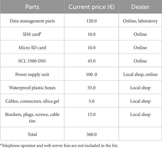
Table 4. Low-cost inclinometer’s price and dealers.
Data availability statement
The raw data supporting the conclusions of this article will be made available by the authors, without undue reservation.
Author contributions
DC: Formal Analysis, Investigation, Validation, Methodology, Writing – original draft, Writing – review and editing. GL: Formal Analysis, Validation, Writing – review and editing. DM: Conceptualization, Writing – review and editing, Validation. PR: Funding acquisition, Project administration, Validation, Supervision, Writing – review and editing.
Funding
The author(s) declare that financial support was received for the research and/or publication of this article. This research activity was funded by the LIVES project (PRIN 2022 prot. 20224ZNHPA, Resp. PR).
Acknowledgments
The authors would like to express their gratitude to the reviewers for their insightful criticism that enhanced the quality of this manuscript. The authors would also like to thank the homeowners Antonio Martino and Maria Iorizzo for allowing us to install the devices and to perform the indoor monitoring test.
Conflict of interest
The authors declare that the research was conducted in the absence of any commercial or financial relationships that could be construed as a potential conflict of interest.
Generative AI statement
The author(s) declare that no Generative AI was used in the creation of this manuscript.
Any alternative text (alt text) provided alongside figures in this article has been generated by Frontiers with the support of artificial intelligence and reasonable efforts have been made to ensure accuracy, including review by the authors wherever possible. If you identify any issues, please contact us.
Publisher’s note
All claims expressed in this article are solely those of the authors and do not necessarily represent those of their affiliated organizations, or those of the publisher, the editors and the reviewers. Any product that may be evaluated in this article, or claim that may be made by its manufacturer, is not guaranteed or endorsed by the publisher.
Supplementary material
The Supplementary Material for this article can be found online at: https://www.frontiersin.org/articles/10.3389/feart.2025.1662640/full#supplementary-material
References
Ahmad, S., Rizvi, Z. H., Arp, J. C. C., Wuttke, F., Tirth, V., and Islam, S. (2021). Evolution of temperature field around underground power cable for static and cyclic heating. Energies 14, 8191. doi:10.3390/en14238191
Ahmad, S., Rizvi, Z. H., and Wuttke, F. (2025a). Unveiling soil thermal behavior under ultra-high voltage power cable operations. Sci. Rep. 15, 7315. doi:10.1038/s41598-025-91831-1
Ahmad, S., Ahmad, S., Akhtar, S., Ahmad, F., and Ansari, M. A. (2025b). Data-driven assessment of corrosion in reinforced concrete structures embedded in clay dominated soils. Sci. Rep. 15, 22744. doi:10.1038/s41598-025-08526-w
Andò, B., Baglio, S., and Pistorio, A. (2018). A low cost multi-sensor system for investigating the structural response of buildings. Ann. Geophys. 61, SE217. doi:10.4401/ag-7702
Andò, B., Castorina, S., Graziani, S., Greco, D., Manenti, M., and Pistorio, A. (2023). “An embedded multi-sensor architecture for applications in structural health monitoring,” in 2023 IEEE Sensors Applications Symposium (SAS). Presented at the 2023 IEEE Sensors Applications Symposium (SAS). Ottawa, ON, Canada: IEEE, 1–5. doi:10.1109/SAS58821.2023.10253981
Andò, B., Greco, D., Navarra, G., and Lo Iacono, F. (2024). A low-cost sensing solution for SHM, exploiting a dedicated approach for signal recognition. Sensors 24, 4023. doi:10.3390/s24124023
Barile, G., Ferri, G., Leoni, A., Muttillo, M., Pantoli, L., Stornelli, V., et al. (2017). Automatic wireless monitoring system for real-time rock fall events, in: proceedings of eurosensors 2017, Paris, France, 3–6 September 2017. Present. at Eurosensors, MDPI. doi:10.3390/proceedings1040569
Benoit, L., Briole, P., Martin, O., Thom, C., Malet, J.-P., and Ulrich, P. (2015). Monitoring landslide displacements with the Geocube wireless network of low-cost GPS. Eng. Geol. 195, 111–121. doi:10.1016/j.enggeo.2015.05.020
Bertagnoli, G., Anerdi, C., and Ferrara, M. (2021). Structural health monitoring issues using inclinometers on prestressed concrete girder bridge decks. IOP Conf. Ser. Mater. Sci. Eng. 1203, 032101. doi:10.1088/1757-899X/1203/3/032101
Brito, D. S. S. D., Santos, L. M. D., Santos, F. L., and Scinocca, F. (2025). Development of a low-cost structural health monitoring system applied to wooden bridges as a management tool. Cad. Pedagógico 22, e14076. doi:10.54033/cadpedv22n4-127
Caballero-Russi, D., Ortiz, A. R., Guzmán, A., and Canchila, C. (2022). Design and validation of a low-cost structural health monitoring system for dynamic characterization of structures. Appl. Sci. 12, 2807. doi:10.3390/app12062807
Cifaldi, D., Mazza, D., Guadagno, F. M., and Revellino, P. (2025). A new IoT low-cost bi-directional wire extensometer for landslide monitoring. Front. Earth Sci. 12, 1494067. doi:10.3389/feart.2024.1494067
Fang, K., Dong, A., Tang, H., An, P., Wang, Q., Jia, S., et al. (2024). Development of an easy-assembly and low-cost multismartphone photogrammetric monitoring system for rock slope hazards. Int. J. Rock Mech. Min. Sci. 174, 105655. doi:10.1016/j.ijrmms.2024.105655
Girolami, A., Brunelli, D., and Benini, L. (2017). “Low-cost and distributed health monitoring system for critical buildings,” in 2017 IEEE workshop on environmental, Energy, and Structural Monitoring Systems (EESMS). Presented at the 2017 IEEE workshop on environmental, Energy, and Structural Monitoring Systems (EESMS) (Milan, Italy: IEEE), 1–6. doi:10.1109/EESMS.2017.8052686
Guerriero, L., Revellino, P., Coe, J. A., Focareta, M., Grelle, G., Albanese, V., et al. (2013). Multi-temporal maps of the Montaguto Earth Flow in Southern Italy from 1954 to 2010. J. Maps 9, 135–145. doi:10.1080/17445647.2013.765812
Guerriero, L., Diodato, N., Fiorillo, F., Revellino, P., Grelle, G., and Guadagno, F. M. (2015). Reconstruction of long-term earth-flow activity using a hydroclimatological model. Nat. Hazards 77, 1–15. doi:10.1007/s11069-014-1578-5
Guerriero, L., Guerriero, G., Grelle, G., Guadagno, F. M., and Revellino, P. (2017). Brief communication: a low-cost arduino® -based wire extensometer for earth flow monitoring. Nat. Hazards Earth Syst. Sci. 17, 881–885. doi:10.5194/nhess-17-881-2017
Guerriero, L., Revellino, P., Grelle, G., Diodato, N., Guadagno, F. M., and Coe, J. A. (2018). “The Montaguto earth flow: nine years of observation and analyses,” in Landslides and engineered slopes. Experience, theory and practice. Editors S. Aversa, L. Cascini, L. Picarelli, and C. Scavia (CRC Press), 1035–1042. doi:10.1201/9781315375007-113
Guerriero, L., Prinzi, E. P., Calcaterra, D., Ciarcia, S., Di Martire, D., Guadagno, F. M., et al. (2021). Kinematics and geologic control of the deep-seated landslide affecting the historic center of Buonalbergo, southern Italy. Geomorphology 394, 107961. doi:10.1016/j.geomorph.2021.107961
Hungr, O., Leroueil, S., and Picarelli, L. (2014). The Varnes classification of landslide types, an update. Landslides 11, 167–194. doi:10.1007/s10346-013-0436-y
Komarizadehasl, S., Komary, M., Alahmad, A., Lozano-Galant, J. A., Ramos, G., and Turmo, J. (2022). A novel wireless low-cost inclinometer made from combining the measurements of multiple MEMS gyroscopes and accelerometers. Sensors 22, 5605. doi:10.3390/s22155605
Komary, M., Alahmad, A., Komarizadehasl, S., Turmo, J., Lozano-Galant, J. A., and Sun, Y. (2023). “A novel low-cost inclinometer sensor based on fusion technology for structural health monitoring applications,” in Life-Cycle of structures and infrastructure systems (London: CRC Press), 1729–1736. doi:10.1201/9781003323020-212
Konovalov, S., Mayorov, D., Ponomarev, Y., and Soloveva, T. (2018). “High-precision smart system on accelerometers and inclinometers for structural health monitoring: development and applications,” in 2018 12th France-Japan and 10th Europe-Asia congress on mechatronics. Presented at the 2018 12th France-Japan and 10th Europe-Asia congress on mechatronics (Tsu: IEEE), 52–57. doi:10.1109/MECATRONICS.2018.8495730
Leone, G., D’Agostino, N., Esposito, L., and Fiorillo, F. (2023). Hydrological deformation of karst aquifers detected by GPS measurements, Matese massif, Italy. Environ. Earth Sci. 82, 240. doi:10.1007/s12665-023-10905-3
Leone, G., Ginolfi, M., Esposito, L., and Fiorillo, F. (2024). Relationships between river and groundwater flow in an alluvial plain by time series analysis and numerical modeling. Water Resour. Manage 38, 2851–2868. doi:10.1007/s11269-024-03795-y
Li, D., Du, Y., Zhang, Q., Huang, G., Wang, L., Bai, Z., et al. (2025). Low-cost miniaturized GNSS antenna for landslide monitoring and application in baige landslide (western China). Adv. Space Res. 76, 128–142. doi:10.1016/j.asr.2025.04.046
Li, E., Zhong, J., Jian, J., Hao, Y., and Chang, H. (2025). On enhancing the accuracy of inclinometer based on multiple dual-axis MEMS accelerometers fusion. J. Mech. Sci. Technol. 39, 1329–1337. doi:10.1007/s12206-025-0227-0
Lozano, F., Emadi, S., Komarizadehasl, S., González-Arteaga, J., and Xia, Y. (2024). Enhancing performance evaluation of low-cost inclinometers for the long-term monitoring of buildings. J. Build. Eng. 87, 109148. doi:10.1016/j.jobe.2024.109148
Nguyen, T., Chan, T. H. T., Thambiratnam, D. P., and King, L. (2015). Development of a cost-effective and flexible vibration DAQ system for long-term continuous structural health monitoring. Mech. Syst. Signal Process. 64–65, 313–324. doi:10.1016/j.ymssp.2015.04.003
Paganis, A., Georgiannou, V. N., Lignos, X., and El Dahr, R. (2025). Laboratory evaluation of a low-cost micro electro-mechanical systems sensor for inclination and acceleration monitoring. Deep Undergr. Sci. Eng. 4, 46–54. doi:10.1002/dug2.12135
Pavanello, M., Bordoni, M., Vivaldi, V., Reguzzoni, M., Tamburini, A., Villa, F., et al. (2024). Low-cost sensors for the measurement of soil water content for rainfall-induced shallow landslide early warning systems. Water 16, 3244. doi:10.3390/w16223244
Pehlivan, H., and Bayata, H. F. (2016). Usability of inclinometers as a complementary measurement tool in structural monitoring. Struct. Eng. Mech. 58, 1077–1085. doi:10.12989/SEM.2016.58.6.1077
Ragnoli, M., Leoni, A., Barile, G., Ferri, G., and Stornelli, V. (2022). LoRa-Based wireless sensors network for rockfall and landslide monitoring: a case study in pantelleria island with portable LoRaWAN access. JLPEA 12, 47. doi:10.3390/jlpea12030047
Revellino, P., Guerriero, L., Ruzza, G., and Guadagno, F. M. (2021). “Defining kinematic and evolutive features of Earth flows using integrated monitoring and low-cost sensors,” in Understanding and reducing landslide disaster risk, ICL contribution to landslide disaster risk reduction. Editors N. Casagli, V. Tofani, K. Sassa, P. T. Bobrowsky, and K. Takara (Cham: Springer International Publishing), 25–40. doi:10.1007/978-3-030-60311-3_2
Ruzza, G., Guerriero, L., Revellino, P., and Guadagno, F. M. (2020). A multi-module fixed inclinometer for continuous monitoring of landslides: design, development, and laboratory testing. Sensors 20, 3318. doi:10.3390/s20113318
Scarpelli, G., Ferretti, A., Mammoliti, E., Ruggeri, P., and Sakellariadi, E. (2024). Ground investigation: a tool for landslide risk mitigation of infrastructures. Procedia Struct. Integr. 62, 530–537. doi:10.1016/j.prostr.2024.09.075
Scuro, C., Lamonaca, F., Porzio, S., Milani, G., and Olivito, R. S. (2021). Internet of things (IoT) for masonry structural health monitoring (SHM): overview and examples of innovative systems. Constr. Build. Mater. 290, 123092. doi:10.1016/j.conbuildmat.2021.123092
Vacalebre, A., Campagna, F., and Specogna, R. (2024a). Simulation-driven machine learning for position estimation in PCB-based tilt inductive position sensors. doi:10.36227/techrxiv.172166240.04918501/v1
Vacalebre, A., Campagna, F., and Specogna, R. (2024b). “Simulation-driven machine learning for solving the inverse problem of PCB-based tilt-inductive position sensors,” in 2024 IEEE 21st biennial conference on electromagnetic field computation (CEFC). Presented at the 2024 IEEE 21st biennial conference on electromagnetic field computation (CEFC) (IEEE). doi:10.1109/CEFC61729.2024.10585990
Villacorta, J. J., del-Val, L., Martínez, R. D., Balmori, J.-A., Magdaleno, Á., López, G., et al. (2021). Design and validation of a scalable, reconfigurable and low-cost structural health monitoring system. Sensors 21, 648. doi:10.3390/s21020648
Warsi, Z. H., Irshad, S. M., Khan, F., Shahbaz, M. A., Junaid, M., and Amin, S. U. (2019). “Sensors for structural health monitoring: a review,” in 2019 second international conference on latest trends in electrical engineering and computing technologies (INTELLECT). Presented at the 2019 second international conference on latest trends in electrical engineering and computing technologies (INTELLECT) (Karachi, Pakistan: IEEE), 1–6. doi:10.1109/INTELLECT47034.2019.8955453
Werthmann, C., Sapena, M., Kühnl, M., Singer, J., Garcia, C., Breuninger, T., et al. (2024). Insights into the development of a landslide early warning system prototype in an informal settlement: the case of Bello Oriente in Medellín, Colombia. Nat. Hazards Earth Syst. Sci. 24, 1843–1870. doi:10.5194/nhess-24-1843-2024
Wierzbicki, S., Pióro, Z., Osiniak, M., and Antoszkiewicz, E. (2020). Inclinometer method of displacement measurements as an alternative to optical measurements in structural health monitoring — laboratory tests. Archives Civ. Eng., 147–164. doi:10.24425/ace.2020.131802
Yang, Q., Cai, C., Yang, M., Kong, M., Liu, Z., and Liang, F. (2022). Dynamic tilt testing of MEMS inclinometers based on conical motions. Metrology Meas. Syst., 31–47. doi:10.24425/mms.2023.144398
Yang, Y., Xu, W., Gao, Z., Yu, Z., and Zhang, Y. (2023). Research progress of SHM system for super high-rise buildings based on wireless sensor network and cloud platform. Remote Sens. 15, 1473. doi:10.3390/rs15061473
Zonzini, F., Malatesta, M. M., Bogomolov, D., Testoni, N., Marzani, A., and De Marchi, L. (2020). Vibration-based SHM with up-scalable and low-cost sensor networks. IEEE Trans. Instrum. Meas., 1. doi:10.1109/TIM.2020.2982814
Keywords: landslide monitoring, structural health monitoring, low-cost inclinometer, 3D-MEMS, Arduino©, Internet of Things (IoT)
Citation: Cifaldi D, Leone G, Mazza D and Revellino P (2025) A new low-cost inclinometer for landslide related structural health monitoring. Front. Earth Sci. 13:1662640. doi: 10.3389/feart.2025.1662640
Received: 09 July 2025; Accepted: 29 September 2025;
Published: 16 October 2025.
Edited by:
Wen Nie, Jiangxi University of Science and Technology, ChinaReviewed by:
Zarghaam Rizvi, GeoAnalysis Engineering GmbH, GermanyKun Fang, Hong Kong University of Science and Technology, Hong Kong SAR, China
Copyright © 2025 Cifaldi, Leone, Mazza and Revellino. This is an open-access article distributed under the terms of the Creative Commons Attribution License (CC BY). The use, distribution or reproduction in other forums is permitted, provided the original author(s) and the copyright owner(s) are credited and that the original publication in this journal is cited, in accordance with accepted academic practice. No use, distribution or reproduction is permitted which does not comply with these terms.
*Correspondence: Daniele Cifaldi, ZGNpZmFsZGlAdW5pc2FubmlvLml0