 Baolong Jiang
 Tao Jiang
 Jingyi Si
 Yuhao Huang
 Yuxuan Du
 Yile Chen
- 1College of Art, Xi’an University of Architecture and Technology, Xi’an, China
- 2College of Forestry, Gansu Agricultural University, Lanzhou, China
- 3Institute of Urban and Sustainable Development, City University of Macau, Macau, China
- 4Faculty of Humanities and Arts, Macau University of Science and Technology, Taipa, China
Settlements in the Multi-ethnic Areas (SiMAs) of the Gansu-Qinghai Plateau reflect the long-term coordinated adaptation of rugged terrain, diverse ethnic cultures, and sacred beliefs, but rapid urbanization and secularization are threatening their spatial integrity. Based on a framework of 10 morphological indicators, this study conducted Principal Component Analysis (PCA) and Agglomerative Hierarchical Clustering analysis on 51 locals SiMAs to reveal the underlying spatial patterns. The results show that (1) four key factors—morphological cognition, structural order, traffic layout, and boundary shaping—greatly help explain the shape of SiMAs, accounting for 78.549% of the total variation. (2) This study identified five typical settlement space paradigms and listed six typical examples to support them. Ethnic settlements under different geographical environments and sacred beliefs have formed adaptive layouts with significant morphological differences. (3) Comparing different cases shows that sacred space, as a fundamental organizing idea, goes beyond ethnic differences to influence how settlements are arranged, while secular space changes and adapts based on various factors. The “spatial organization paradigm” proposed in this study clarifies how nature, culture, and functional drivers interweave to shape plateau settlements and provides a transferable practical path for community participation in conservation and sustainable planning of multi-ethnic mountain heritage sites around the world.
1 Introduction
Typical highland rural settlements around the world—from pueblos in the Andes (Cordillera de los Andes) (Herrán Gómez et al., 2019) to gompas in the Himalayas (Choephel, 2019)—reflect the long-term coordinated adaptation of rugged terrain, multi-ethnic cultures, and belief systems. Since the mid-20th century, under the wave of rapid global urbanization, rural settlements, often regarded as “backward transition zones,” have been concerned not only with physical space, but also with the continuation of ethnic culture, social structure, and ecological balance (Harun et al., 2021). In recent years, climate pressure, tourism impact, and rapid urbanization have continuously eroded the spatial resilience and community identity of rural settlements, making them a hot topic in the fields of architectural space and urban and rural planning. Around the world, problems such as the decline of community cohesion and cultural identity (Ghahramani et al., 2020), illegal occupation of settlement space (Muñoz and Ramos, 2024), imbalanced planning and management mechanisms (Zhong and Dong, 2024), lack of economic development, and population growth (Gizelis et al., 2021) have become increasingly prominent. These problems have posed great challenges to the sustainable development of highland settlements. Although studies have conducted large-scale mapping of mountain villages of a single ethnic group, little is known about the interaction between sacred and secular space in a multi-ethnic highland context.
As the world’s largest developing country, China provides a rich testing ground for this issue. China’s mountains, terraces, and hills account for 74.38% of its land area (Central People’s Government of China), and a large number of rural settlements are distributed in plateaus above 1,000 m above sea level. The Qinghai-Tibet Plateau and the Loess Plateau in the northwest are also major areas where multiple ethnic groups live together in China (Moser, 2019). Their settlement forms are also a true reflection of China’s urban-rural dual structure (Tu and Long, 2020). Although the Comprehensive Rural Revitalization Plan (2024–2027) issued in 2025 advocates “integration of protection and revitalization” (The State Council), it lacks quantitative evidence to support spatial design guidelines. At the same time, existing research mostly stays in the one-dimensional discussion of building types (Ruggiero et al., 2019; Philokyprou and Michael, 2021; Lin et al., 2024) or intangible cultural heritage (Huang et al., 2025a; Nie Z. et al., 2022), lacking an integrated perspective of the two.
In this context, the plateau mountains at the junction of Gansu and Qinghai are particularly prominent due to their ecological fragility and cultural overlap, especially the coexistence of Tibetans (藏族), Hui people (回族), Bonan people (保安族), Han Chinese (漢族), Salar people (撒拉族), and other ethnic groups. The formation of settlements in the region is a dynamic geopolitical historical process: ethnic migration, competition, conflict, adaptation, and integration are the basic patterns of the development of local ethnic relations (Park, 1925), which constantly shape the spatial pattern and social structure of settlements. Zhuangkuo settlements formed to adapt to the high-altitude climate, and ethnic relations have become strong evidence of the interaction between nomadic culture and agricultural civilization (Cui et al., 2012). Ethnic culture and religious beliefs permeate all aspects of regional social structure and settlement space organization. They play an important role in the inheritance of local culture, human-land relations, and the development of economic activities. These settlements are defined as Settlements in Multi-Ethnic Areas (SiMAs) in this study because of their distinctive characteristics of ethnic diversity, cultural identity, and economic complementarity. In addition, sacred space refers to the spatial carrier of transcendental spiritual activities such as religious rituals, folk beliefs, or deity worship in the settlement. It is the spatial anchor of belief practice; secular space refers to the complex functional places that serve the daily production and life of residents. As a container of social relations, it carries local knowledge and reflects the practical rationality of human-land interaction. However, road construction, labor migration, and the commercialization of “heritage tourism” have blurred the boundaries between sacred and secular spaces (Hancock and Srinivas, 2008). We urgently need new understandings of spatial resilience and identity maintenance to counteract the cultural disconnect resulting from modernization.
In response to the above problems, this study constructed a typological-morphological framework with ten indicators in three dimensions: geographical environment, settlement space, and architectural layout. The study used Principal Component Analysis (PCA) and Agglomerative Hierarchical Clustering (AHC) on 51 settlements in the Gansu-Qinghai Plateau, along with GIS mapping and visits to gather local information for checking the results. The study focused on three major questions: (1) What morphological factors dominate the spatial variation of multi-ethnic plateau settlements? (2) What is the interactive influence mechanism between sacred space elements and secular living areas? (3) Can a transferable “space—organization paradigm” be extracted to provide a reference for conservation planning in other regions?
Most existing studies view settlement morphology as the result of a single dominant factor and overlook the dynamic role of sacred beliefs in the formation of ethnic settlement morphology. It is urgent to incorporate the multiple couplings of natural substrates and religious drivers in a unified analytical perspective to unravel the morphogenesis of SiMAs. This study provides a unique religious perspective for analyzing the relationship between people and land to examine the morphology of ethnic settlements; at the same time, it elevates the previous research on single-ethnic settlements in urban morphology to the level of multi-ethnic integration and symbiosis. Finally, the researchers present a clear visual operational pathway for analyzing the morphological patterns of SiMAs in Gansu-Qinghai Plateau by constructing a “paradigm” map. The work provides scientific guidance for the maintenance, renewal design, planning, and governance of the regional spatial characteristics of ethnic settlements. At the same time, this study has reference value for promoting harmonious and diverse multicultural symbiosis.
2 Literature review
This chapter follows the progressive logic of “theoretical origins - method criticism - object focus - gap positioning,” nesting the academic evolution trajectory of morphological typology with the practical needs of multi-ethnic plateau settlement research layer by layer.
2.1 Localization of morphological typology
Typo-Morphology, as an important method for studying urban morphology, aims to analyze urban morphology in a graphical way by deconstructing the morphological characteristics and topological evolution of spatial layout elements and their organizational relationships (Moudon, 1989). In the 1990s, British scholar Kropf Karl integrated the core concepts of urban morphology and architectural typology, successfully promoting the integration of morphology and typology (Kropf, 2013), and bridging the theoretical gap between micro-architectural structure and macro-urban morphology.
The study of Chinese morphological typology began in the early 21st century. Gu (2001) introduced the theory and methods of Conzen urban morphology (Gu, 2001) and conducted a collaborative study on the space of ancient Chinese cities with Whitehand and Gu (2007). The local development of this theory can be divided into three stages: initial theoretical localization construction, mid-term practical exploration and application, and recent expansion and deepening. In the early stage, Chen and Grzybowski (2010) and Tian et al. (2010) explored a new research framework adapted to China’s national conditions based on the theory of morphological typology, which was used for urban morphological research, urban design, and architectural heritage protection (Chen and Grzybowski, 2010; Tian et al., 2010). In the mid-term, this theory was widely used in the fields of historical block protection and renewal (Shen, 2011) and traditional village research (Zhao et al., 2013; Xu et al., 2018) and was deeply integrated with disciplines such as architecture and urban planning. In recent years, with the advancement of rural revitalization, cultural revival, and urban sustainable development strategies, the scope of research has been further expanded to include historical ancient cities and rural settlements of various types in vast areas. These studies use spatial morphology as a medium to link natural constraints, cultural genes, and modern functions and have made important contributions to the morphological changes of rural settlements (Huang et al., 2025b), spatial differentiation (Shi et al., 2022), adaptive construction (Wang and Wang, 2019), protection and renewal (Gao et al., 2024), and regional cultural mapping (Bu and Lai, 2024). In addition, the “space gene” theory proposed by Academician Jin et al. (2019) has become an important branch of the localization of morphological typology (Jin et al., 2019). It focuses on the morphological typological expression of the morphological structure of historical towns in a specific environment. In China, morphological typology has developed from a static classification tool to a core framework that drives the dynamic and sustainable development of rural areas. China’s localized practice provides a “Chinese paradigm” for global rural governance.
However, many current studies have only focused on the analysis of the morphological types and characteristic factors of rural settlement space, and the systematic organization and induction of settlement space organization prototypes is insufficient, and a comprehensive prototype genealogy study has not yet been formed. It lacks cross-regional, large-scale settlement morphology and organization prototype classification. In addition, the exploration of the multiple adaptation mechanism of the settlement system under the coupling of human-land relationship also needs further interpretation.
2.2 Practical analysis of morphological typology in settlement spatial order
Based on tracing the origins and clarifying the evolution of morphological typology and its localized application in China, this section reflects on the methodological level and attempts to build a research framework based on theory. Morphological typology uses the analytical framework of urban morphology on the structure and characteristics of material forms and the evolutionary perspective of architectural typology to examine the social logic of urban form generation and evolution (Chen et al., 2017). It not only reveals the evolution process of material space form but also provides the possibility for the study of the derivation and generalization of space. The urban built environment is a process. The generation and evolution of the urban built environment’s form stem from the close relationship between architectural texture, the natural environment, and social humanities. The three constitute a dynamic equilibrium system of mutual dependence and mutual restraint. Specifically, the natural environment is the material basis and fundamental constraint of the system operation, which provides basic resources (water, plants, animals) and restrictive conditions (topography, climate). Social humanities (culture, economy, values, etc.) are the core driving force of the system evolution, which determines the cognition of the natural environment and the use and transformation of space. Architectural texture is the material presentation of the joint action of natural constraints and human needs. It is not only a spatial carrier for human adaptation and transformation of nature; its form and function, in turn, affect natural processes and human activities.
From the perspective of morphological typology, the evolution of the built environment is a combination of synchronous variations and diachronic variations, which are two characteristics of the evolution of the architectural archetype (leading type) (Rahbarianyazd, 2020). In addition, both the “Morphological Period” and the “Typological Process“ believe that urban form is a collection of morphological elements with similar composition methods. M.R.G. Conzen proposed the concept of “morphogenetic priority” (Slater, 2000). It points out that the influence of multi-level morphological elements on urban spatial form has different genetic stability or vitality. This clearly indicates the preservation of the established spatial order during the evolution of settlement morphology and the adaptive renewal of the complex urban system resulting from interactions between humans and land. This is the self-organizing operation mode of settlement morphological development. Therefore, studying the spatial organization mode of the built environment of settlements based on morphological typology seems to be a feasible research path. It is no longer limited to the isolated study of spatial material forms but provides a local mechanism explanation for the morphological formation of settlements from the perspective of diachronic evolution and synchronic derivation (Figure 1).
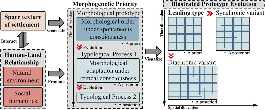
Figure 1. The explanatory model of typo-morphology for spatial heredity (image source: drawn by the authors).
Most current research on types of settlement shapes mainly looks at how these shapes change over time or what materials create them (Table 1). Among them, the former perspective focuses on exploring the social structural changes that occur behind morphological changes (the interaction between space and people) (Jiang et al., 2025; Thinh and Kamalipour, 2022; Xv et al., 2019; Ünlü and Baş, 2017). However, its emphasis on individual initiative largely ignores the underlying constraints that environmental factors impose on morphology, making it difficult for qualitative analysis to accurately identify the trends in morphological evolution. Additionally, the latter looks at the makeup of spatial morphology and how it interacts with the natural environment based on construction outcomes (how space fits with nature) (Huang et al., 2025b; Shi et al., 2022; Kamalipour and Iranmanesh, 2021). However, it is a product of “geographical spatial determinism” and weakens the environmental adaptation and active shaping power of humanity. Both lack analysis of spatial organizational relationships in value orientation and technical application and regard space as a template organization of “form + function”. At the same time, their research further separates the relationship between “people-land-settlement”. This viewpoint is not conducive to grasping the inherent spatial order and system generation mechanism of the complex development process in settlement space.
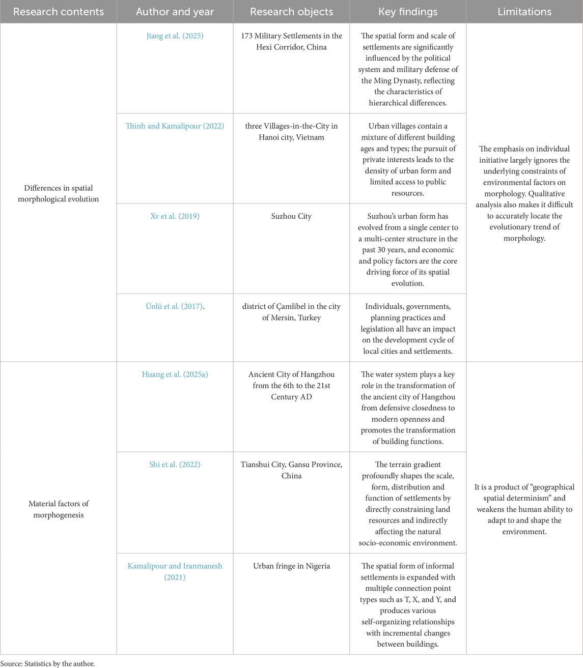
Table 1. Two major perspectives of existing morphological typology research.
2.3 Settlement space of ethnic group
Based on the unclear mechanism of settlement morphology generation under the “people-land-settlement” framework pointed out above, this section reviews previous research on ethnic settlements and explains the necessity of research in the context of multi-ethnic cohabitation.
The term “ethnic group” is mainly used to describe the characteristics of a group of immigrants that are different from the mainstream society in terms of religion, language, etc. (Nianxing, 2009). Early geographers believed that the formation of the spatial form of European settlements was related to the distribution and migration of ethnic groups (Meitzen, 1895). Dear (2001) regarded this multi-ethnic culture mixed in the city as part of the “socio-cultural” driving force (Dear, 2001). The religious sacredness and cultural interaction of ethnic groups have had a long-term impact on the development of settlement space (Siwi et al., 2020).
Although the expansion of urban roads and the popularization of infrastructure such as communications and media have provided various conveniences for the life of ethnic settlements, the development of ethnic settlements and the continuation of their unique culture are facing the dual threats of urban modernization and religious secularization (Burchardt, 2021; Hua and Nakatani, 2025). This situation is similar to the concept of “Disenchantment (Entzaubern)” proposed by German sociologist Weber et al. (1994). This concept is used to describe the process of eliminating all mysterious elements through rational thinking in the process of social modernization, turning the world towards secularization and rationalism (Weber et al., 1994). Some scholars have emphasized the importance of reshaping the social and cultural identity of the sacred space of settlements under the impact of modernization (Zhang, 2022; Zou and Bahauddin, 2024). In fact, the convergence of traditional village characteristics and the desacralization and secularization of religious space have continuously weakened the sacredness and spirituality of religious belief space and further weakened the community identity and cohesion on which ethnic settlements rely. Their work suggests two major problems facing ethnic settlements: one is how ethnic settlements can maintain the symbiosis and balance of the sacred and the secular in the context of modernization (Woods and Kong, 2022). The second is how to use objective morphological type methods to explore the spatial paradigms of the settlement forms of various ethnic groups in the region and the human-land coupling mechanisms they reflect.
The research methods of ethnic settlement space in the early days were relatively simple, and descriptions based on historical literature and field surveys (Wang et al., 2005) were the common methods. With the development of technology and the improvement of cognitive level, the research on ethnic settlement space has gradually turned to quantitative or the combination of qualitative and quantitative methods. This has promoted precision of theoretical research and spatial measurement. Commonly used mathematical methods can be roughly divided into three types: Euclidean geometry (Ma and Ma, 2007), fractal geometry (Batty and Longley, 1994; Lagarias and Prastacos, 2020; Shen and Fan, 2024), and topological geometry (Tutuko et al., 2021; Stevens and Thai, 2024) (Table 2). These include the measurement of settlement scale and distribution characteristics, self-similarity of complex forms, spatial perception, and connectivity. In addition, GIS technology can efficiently visualize and manage geographic spatial elements (Huang et al., 2024; Nahiduzzaman et al., 2020). By combining it with the above methods, it provides more innovative methods and perspectives for the study of settlement space patterns. However, the use of quantitative indicators in previous studies lacks systematicity, making it insufficient for conducting a comprehensive analysis of the multi-level morphological characteristics of settlement space of ethnic groups.
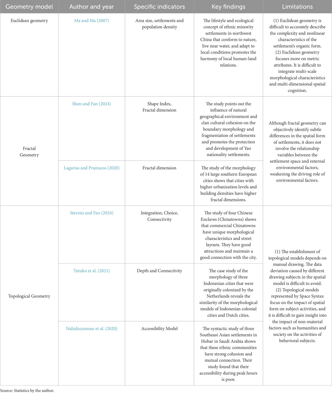
Table 2. Common geometric models in settlement space research.
It can be seen that existing research is mainly carried out from the dual perspectives of human settlement construction and regional social composition, laying the foundation for analyzing the relationship between religious beliefs and settlement space. In terms of content, spatial morphology research looks at how settlements are built and change over time on a medium scale, helping to protect and renew these areas (Xiao et al., 2023; Wu et al., 2024; Gunawan et al., 2023). Ecological sustainability research focuses on the ecological explanation of the geographical environment on settlement development (Xu et al., 2022; Zhang et al., 2023). Social development research reveals the isomorphism between spatial entities and social organizations and cultural heritage (Xu, 2015). Its theoretical basis is mostly based on urban morphology, rural geography, and landscape ecology. The research objects are concentrated on ethnic minority settlements in the Yunnan, Guizhou, and Sichuan regions in southwest China (Xiao et al., 2023; Zheng et al., 2022); Southeast Fujian (Xu et al., 2022), the water-country areas of Jiangsu and Zhejiang (Huang et al., 2025c) and Huguang regions (Li et al., 2023). The exploration of the “sacred-secular” interaction mechanism of settlements in high-altitude multi-ethnic areas (such as the Qinghai-Tibet Plateau) needs to be deepened.
2.4 Summary of related research progress
This section summarizes the above three clues into a triple gap and demonstrates the necessity of establishing a “progressive-hierarchical-structured” quantitative framework.
Rich research methods and theoretical frameworks have facilitated the systematic understanding of ethnic settlements. However, current research on ethnic settlements still has limitations. First, morphological type research isolates the differences in the appearance of settlement morphology from the driving factors. This process leads to the “static” and “linear” nature of morphological type research. It only regards morphology as the result of static classification and the linear causal relationship between a single dominant factor. Secondly, when looking at different ethnic groups, religious beliefs are often seen as simple parts of the environment, without showing how they actually affect the shape of settlements beforehand; at the same time, we also need to look more closely at how religious organizations play a key role in shaping spaces, how different ethnic groups interact in these areas, and how faith and administrative boundaries change over time. Finally, the complex spatial practices of multi-ethnic mixed settlements in plateau mountains have been ignored, and the separation of the “people-land-settlement” relationship and research scale has caused cognitive biases in the local generation mechanism of settlements (especially sacred and secular spaces). These limitations not only blur the interaction between religious beliefs, as the core humanistic driving force, behind settlement morphology and spatial organization, but also hinder the in-depth understanding of the complex adaptation mechanism of multi-ethnic mixed settlements.
Up to now, no studies have clearly shown how sacred and secular aspects are connected in multi-ethnic plateau settlements; the current research on creating mathematical indicators often does not fully examine the different shapes and overlooks religious understanding. Therefore, it is necessary to establish a systematic methodology to conduct a deeper discussion on the local characteristics of SiMAs. The use of step-by-step, organized, and detailed measurement methods aims to thoroughly investigate how natural factors and human activities influence the shape and design of local SiMAs.
3 Materials and methods
3.1 Study area: Baizhuang Town and Daowei Tibetan Township
This study is located in Xunhua Salar Autonomous County (35°25′N–35°56′N, 102°E–102°49′E) (Figures 2a,b) in Haidong City, Qinghai Province, northwest China, which has a typical plateau continental climate. The focus is on Baizhuang Town (白莊鎮) and Daowei Tibetan Township (道帷藏族鄉) in its southeast (total area 846.49 km2, altitude 2024–4,640 m) (Figure 2cC). There are 51 ethnic villages in the territory. Among them, there are 27 in Daowei Tibetan Township and 24 in Baizhuang Town. The area belongs to the transition zone from the Loess Plateau to the Qinghai-Tibet Plateau, with the mountainous and hilly landforms at the eastern end of Laji Mountain as the main feature, and the settlements are distributed along the Qingshui River (a tributary of the Yellow River). As a multi-ethnic intersection area in the highland cold region, Tibetans, Hui people, Han Chinese, and Salar people have formed a symbiotic pattern under the diverse belief systems of Tibetan Buddhism, Confucianism, Taoism, and Islam, and they have long been coping with the harsh climate and complex geopolitical environment. The region’s intersecting geomorphologies, intermingling ethnic groups, overlapping cultures, and diverse spatial organization make it a prime location for the study of settlements in multiethnic areas. It is not only a multicultural belt where multiple ethnic groups and faiths coexist but also a representative sample area for exploring the coupling mechanisms and research frameworks of “people-land-settlement.”
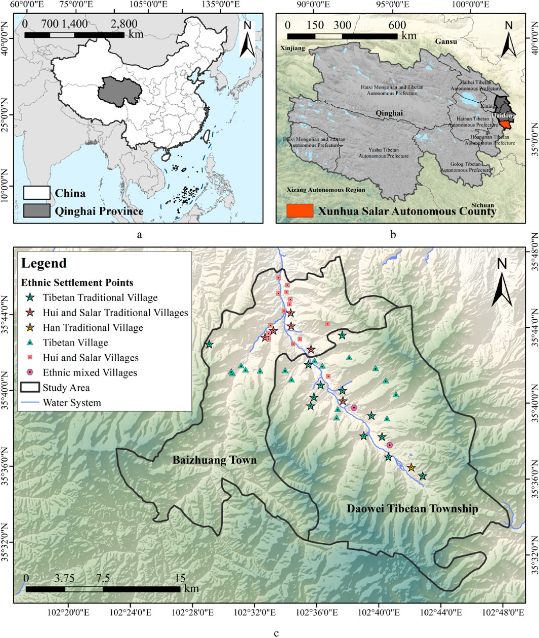
Figure 2. The location of the study area and distribution of SiMAs: (a) The location of Qinghai Province, China; (b) The location of Xunhua Salar Autonomous County in Haidong; (c) The location of SiMAs in Baizhuang Town and Daowei Tibetan Township, Xunhua Salar Autonomous County (image source: drawn by the authors).
3.2 Data source and preprocessing
This study includes the following data (Table 3):
1. Geospatial data. This type of data includes satellite image data, DEM (digital elevation model) data, water system data, and administrative division data. In addition, this study combined the public information provided by the National Bureau of Statistics of China (https://www.stats.gov.cn/, accessed on 1 May 2025) to determine all village-level administrative units in the study area.
2. Settlement spatial morphological data. This study selected all settlement samples in the region whose spatial morphological characteristics are typical and can be used as the sample basis for extracting the “spatial organization paradigm.” This type of data includes settlement boundary morphology, road network structure, building and public space texture. Based on field research and Google satellite images at levels 18 and 19, we used ArcGIS 10.8 to draw settlement patches for research. At the same time, we screened and counted representative buildings (residential houses, religious buildings) in local SiMAs to confirm the location of the patches.
3. Field research and mapping. The research team conducted a field survey of representative buildings (residential buildings, religious buildings) in local SiMAs to confirm and count their patch locations. Through consultation with local residents, we mastered the spatial layout of some residential buildings, laying the foundation for analyzing the sacred-secular relationship of residential space.
4. SiMAs morphological information database. Based on the above data preprocessing, we used ArcGIS 10.8, AutoCAD (2018 Version), and Microsoft Excel (2023 version) to save the settlement morphological pattern and spatial data, thereby constructing a morphological information database of local SiMAs.
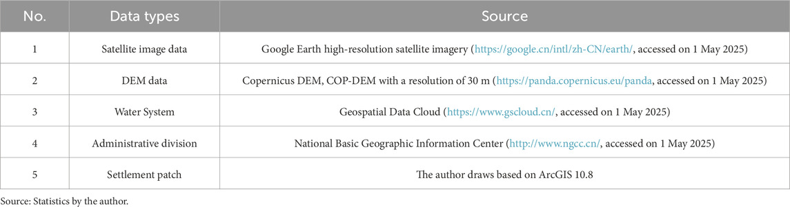
Table 3. Research data sources.
3.3 Research process and methods
3.3.1 Research process
In the face of the complex adaptive development of urban modernization, this study attempts to analyze the morphological derivative relationship of settlement space in multi-ethnic mixed areas based on morphological typology. We construct a structured “spatial organization paradigm” graphical language framework. It is used to identify and study how the layout and arrangement of SiMAs in the Gansu-Qinghai Plateau are affected by various factors and elements that change at the same time. Therefore, this study follows the research path of “quantitative indicator analysis-morphological type analysis-paradigm map construction” (Figure 3). First, in the selection of quantitative indicators, we construct a “macro-meso-micro” multi-level and multi-scale analysis framework based on “geographical environment-settlement morphology-architectural layout”, and comprehensively consider three-dimensional terrain and two-dimensional morphological factors. On this basis, the study sets up 10 indicators to identify the morphological characteristics of 51 SiMAs in study area. Then, using the numbers we gathered, we analyze the main components and group similar characteristics, and we explain how they came to be. The study creates a framework for understanding the layout of SiMAs in the Gansu-Qinghai Region, considering how people interact with the land and how religious beliefs shape both sacred and everyday spaces. Finally, guiding strategies are provided for the settlement heritage planning and spatial restoration of local SiMAs in the future.
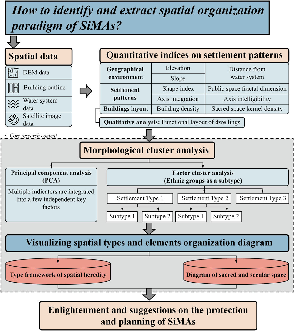
Figure 3. The research framework of SiMAs morphological feature extraction (image source: drawn by the authors).
3.3.2 Quantitative indicators of morphological feature
This study quantitatively analyzes both two-dimensional plane morphology and three-dimensional geographic space. We use three models of Euclidean geometry, fractal geometry, and topological geometry for analysis. The corresponding methods are GIS spatial data collection (ArcGIS 10.8), fractal measurement, and space syntax (DepthMap beta 1.0). The specific indicator definitions and method applications are as follows (Table 4):
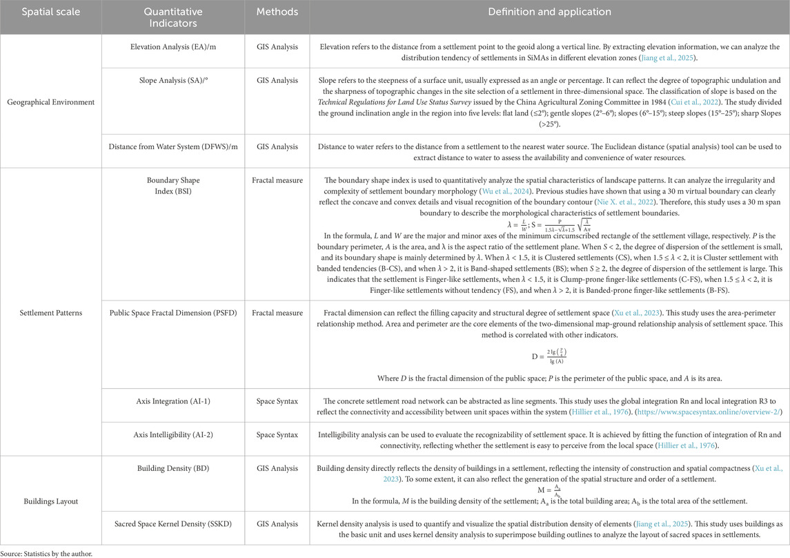
Table 4. Quantitative indices and definitions of morphological features.
In addition, based on the investigation and mapping of different residential buildings, the researchers analyzed their interior layouts and clarified the differences in spatial and functional organization of village dwellings of different ethnic groups to improve the spatial penetration of sacred imagery into secular life. This helps to reveal the multi-scale association mechanism between sacred and secular space.
3.3.3 Clustering of settlement morphology
This study used Principal Component Analysis (PCA) and Agglomerative Hierarchical Clustering (AHC) to classify settlement morphology with the help of IBM SPSS Statistics Version 27. PCA extracts principal component factors with a contribution rate of ≥70% by reducing dimensionality and integrates quantitative indicators to reveal the core morphological generation mechanism (Bryant and Yarnold, 1995); AHC iteratively clusters based on the proximity relationship between morphological data to avoid subjective classification bias (Dubes, 1999). The combination of the two methods objectively quantifies the morphological characteristics of settlements and achieves scientific classification.
4 Results
4.1 Descriptive statistics of 10 indicators
4.1.1 Geographical environment indices
The geographical environment is the carrier of rural settlements. The location, scale, form, and architectural style of settlements are all affected by the natural environment. In the long-term interaction between people and land, different ethnic groups have built adaptive human settlements based on the natural environment. Due to differences in altitude, climate, landform, vegetation type, and agricultural conditions, the local area can be roughly divided into the Alpine meadow area (3,200–4,640 m), the Plateau hill area (Naoshan) (2,800–3,200 m), the Shallow hill area (Qianshan) (2,200–2,800 m), and the Valley plain area (Chuanshui) (2,024–2,200 m) (Figure 4).
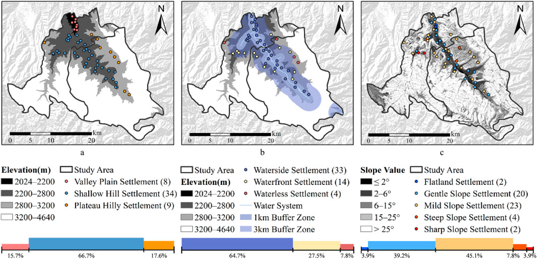
Figure 4. Distribution of local SiMAs under different geographical factors: (a) Distribution of Settlement Types under elevation factors; (b) Distribution of Settlement Types under water system factors; (c) Distribution of Settlement Types under slope factors (image source: drawn by the authors).
4.1.1.1 Elevation analysis (EA)
The study area has a large difference in altitude and complex terrain. The local multi-ethnic settlements are mainly distributed in the range of 2,053–3,099 m above sea level (Supplementary Table SA1 in Appendix A). The settlement types can be roughly divided into valley plain (Chuanshui) settlements, shallow hilly (Qianshan) settlements, and plateau hilly (Naoshan) settlements (Figure 4a). Among them, most settlements are distributed in low mountain and hilly areas (2,200–2,800 m). There are 34 of them, accounting for 66.7%. The Alpine Meadow area has no large-scale settlement environment due to its high altitude and unsuitability for agricultural production.
4.1.1.2 Distance from water system (DFWS)
The water system is an important factor in the development of residents’ lives, agriculture, and animal husbandry. This study uses Euclidean distance to analyze the vertical distance from the settlement center to the water system (Supplementary Table SA1 in Appendix A) and uses buffer zone analysis to illustrate (Figure 4b). Among them, 64.7% of the settlements were built by the waterside, with a total of 34 settlements. They are all located within the 1 km buffer zone of the water system to facilitate water collection for production and life. There are 14 settlements within the 3 km water system buffer zone, accounting for 27.5%. Only four settlements have a straight-line distance of more than 3 km from the water system, which are waterless settlements. As shown in Figure 4b, the distribution of SiMAs has a good fitting relationship with the direction of the water system.
4.1.1.3 Slope analysis (SA)
Slope is an important indicator for analyzing settlement site selection and spatial layout. The study combined the settlement locations with the slope data to find out the slope values for each settlement (see Supplementary Table SA1 in Appendix A) and created a diagram showing how settlements are distributed based on slope (see Figure 4c). In the region, the highest slope value of the settlement is 31.29° and the lowest is 1.35°. Among them, the vast majority of settlements are in the range of gentle slopes (2°–6°) and slopes (6°–15°), with 20 and 23 settlements, accounting for 39.2% and 45.1%, respectively.
On the other hand, the settlements in the multi-ethnic groups’ region are restricted by the environment of less flat land and more mountainous hills, and the settlements are mostly distributed along the gentle slopes and slopes on both sides of the Qingshui River Valley. At the same time, the elevation selection of settlements is restricted by multiple factors, such as vegetation type and agricultural and animal husbandry production, and it is widely distributed in the valley plain area (Chuanshui), shallow hill area (Qianshan), and plateau hill area (Naoshan).
4.1.2 Indices of settlement patterns
Settlement morphology includes settlement boundary shape index, public space fractal dimension, axis integration, and axis comprehensibility. Among them, the shape index reflects the fragmentation and complexity of the settlement boundary. The public space fractal dimension reflects the structural compactness and densification of the settlement space. The axis integration shows how easy it is to get around the settlement’s transportation network, while intelligibility indicates how recognizable the settlement space is. The above factors express the morphological characteristics within the village.
4.1.2.1 Boundary shape index (BSI)
The aspect ratios λ of the settlements in the multi-ethnic groups in this region are 1.058–4.532, and the shape index is 1.113–5.476 (see Supplementary Table SA1 in Appendix A). This information indicates that the morphological characteristics of the settlement samples vary greatly. Based on the quantitative results, this study summarized the 51 settlement samples into six categories (Table 5): clump-prone finger-like settlements and finger-like settlements without tendency are the most common, with 16 each. Banded-prone finger-shaped settlements are the second most common. However, clustered settlements, cluster settlements with banded tendencies, and band-shaped settlements are relatively rare, with 3, 1, and 4, respectively. This study shows that a high degree of boundary fragmentation and more complex morphology are the general trends of the local multi-ethnic settlements. Among them, the Salar and Hui settlements tend to be clump-prone finger-shaped settlements and finger-shaped settlements without tendency; the Tibetan settlements tend to be finger-shaped settlements without tendency compared with the Hui and Salar settlements; and the ethnically mixed settlements are finger-shaped settlements with cluster-shaped and band-shaped tendencies.
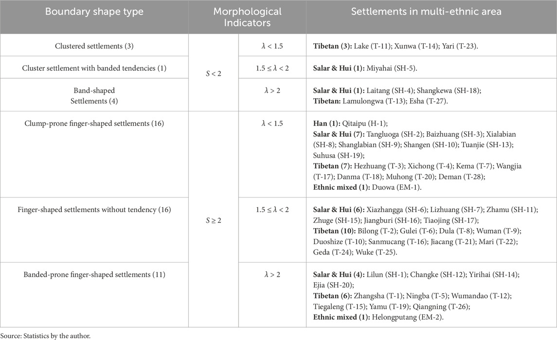
Table 5. Summary of settlements of different boundary shape types.
4.1.2.2 Public space fractal dimension (PSFD)
The PSFD of the settlement samples in the study area is 1.381–1.532 (Supplementary Table SA1 in Appendix A). Among them, the PSFD of the Salar and Hui settlements is 1.406–1.532; the value of the Tibetan settlement is lower than the former, 1.381–1.503; the value of the ethnic mixed settlements is 1.476 and 1.499; and the value of the Han is 1.464. In terms of quantitative indicators, the Salar and Hui settlements have the highest organizational efficiency, and the buildings are more fully developed for filling and expansion within a specific plot. Compared with the former, the upper limit of the PSFD of the Tibetan settlement is second, and the lower limit is lower, indicating that the space of the low PSFD settlement is looser and the sense of space is weaker. The spatial structure of the high PSFD settlement is denser, and the street system is more mature and developed. The PSFD of the ethnic mixed settlements and the Han settlements is higher, and the degree of structuring is satisfactory.
4.1.2.3 Axis integration (AI-1)
The average global integration value Rn of SiMAs in this region was 0.291–0.888 (Supplementary Table SA1 in Appendix A), and the accessibility of different settlement spaces varied greatly. The local integration value R3 of the SiMAs was 0.997–1.395, indicating that the accessibility of settlement spaces in the three topological units was generally high. As for different ethnic settlements, the global integration value Rn of Salar and Hui settlements was 0.404–0.888; the local integration value R3 was 0.997–1.395. The Rn and R3 of Tibetans were 0.291–0.743 and 1.072–1.263, respectively; the Rn of ethnic mixed settlements was 0.625 and 0.753, and the R3 was 1.294 and 1.338; the Rn and R3 of Han settlements were 0.465 and 1.117, respectively.
The data show that the spatial accessibility of Rn in ethnically mixed settlements is relatively stable and good. The spatial accessibility of Salar, Hui, and Tibetan settlements fluctuates greatly, but the transportation network of Hui and Salar settlements has higher connectivity and convenience. The global accessibility of Han settlements is poor. In terms of local integration R3, Salar, and Hui settlements occupy the maximum and minimum values of the data; the local spatial accessibility of ethnically mixed settlements is higher, followed by Tibetans and Han.
4.1.2.4 Axis intelligibility (AI-2)
The intelligence range of the axes of the 51 samples is 0.037–0.774 (Supplementary Table SA1 in Appendix A). Among them, the intelligence
4.1.3 Indices of buildings layout
This study uses the 30 m settlement boundary as the calculation range for building density and sacred space core density.
4.1.3.1 Buildings density (BD)
The data (Supplementary Table SA1 in Appendix A) indicates that the majority of settlements fall within the 0.210–0.401 building density range. Among them, the building density of Salar and Hui settlements is in the range of 0.249–0.401; the value of Tibetan settlements is 0.21–0.398; the values of ethnic mixed settlements are 0.306 and 0.324; and the value of Han settlements is 0.231. Compared with other ethnic settlements, most Salar and Hui settlements have higher building density. The building density of Tibetan settlements is uneven and fluctuates greatly. The building density of Han settlements is the sparsest.
4.1.3.2 Sacred space kernel density (SSKD)
The highest value of building core density of local SiMAs ranges from 1,037.377 to 8,191.626, and the lowest value ranges from 0 to 2,556.299. For different ethnic groups, the highest building core density for the Salar and Hui groups is between 1953.649 and 8,181.626; for Tibetan settlements, it ranges from 1,037.377 to 4,902.227; and for mixed ethnic settlements and the Han group, the values are 2,776.054–3,744.856 and 2,171.402, respectively (Supplementary Table SA1 in Appendix A). This graph shows that the concentration of the building density area of the Salar and Hui settlements is the highest, far exceeding that of other settlements. The spatial utilization rate of the building agglomeration areas of the Tibetan and other settlements is different from that of the former. In general, the building distribution of settlements of different ethnic groups in the region is mostly point-shaped agglomeration to form a ring-shaped agglomeration center. A few settlements show scattered and strip-shaped agglomeration characteristics.
4.1.4 Statistical description of indicator data
The mean, standard deviation, and extreme value of morphological quantitative indicators are shown in Table 6. The study found that when the sample size is sufficient, the Salar and Hui settlements are significantly better than other ethnic settlements in terms of altitude, distance to water, land area, and building core density. They have the morphological characteristics of being located in low places, close to water systems, large groups, and high density. Tibetan settlements have the morphological characteristics of being in high places, choosing mountain systems, fragmented morphology, and being built on slopes. In general, the boundary morphology of the settlements is highly fragmented, and most of them tend to be strip-shaped.
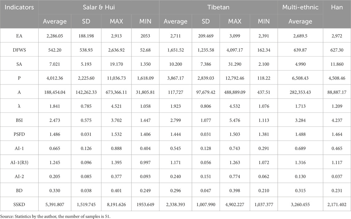
Table 6. Statistical description of indicator data of SiMAs in study area.
4.2 Functional layout of dwellings
Courtyard compound architecture (莊廓建築) is widely used in the study area. It is a courtyard-style building surrounded by a thick rammed earth wall and a gate. Different ethnic groups have made unique modifications to the courtyard compound architecture based on this design (Figure 5). The main space of Tibetan dwellings consists of the main house, bedroom, and Buddhist Hall (Figure 5a). Among them, the Buddhist Hall is for family members to chant scriptures and worship daily. As the main public space in the courtyard, the glass greenhouse is not only a living space that integrates leisure and entertainment and other functions but also effectively improves the indoor thermal insulation performance. Near the gate are mostly livestock rooms and dry toilets. Salar and Hui dwellings are mainly composed of the main room, kitchen, bedroom, and ablution room (Figure 5b). The ablution room, as a sacred space, is mostly connected to the bedroom or main room. The garden enclosed by the building is filled with flowers and plants to decorate the courtyard space. The space of Han dwellings has a clear orientation and axis (Figure 5c). Most of them face north and south, with the main house at the end of the axis and the bedrooms arranged symmetrically on both sides. Near the gate is the grocery room. There are vegetable plots in the courtyard.
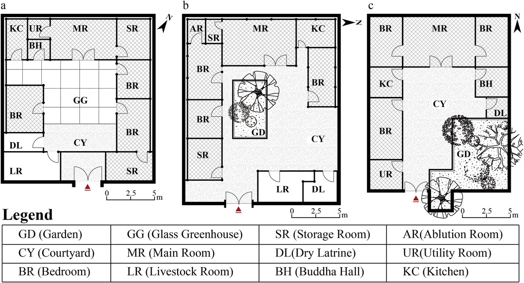
Figure 5. Functional layout of different ethnic dwellings (a) Tibetan dwellings; (b) Salar and Hui dwellings; (c) Han dwellings (image source: drawn by the authors).
4.3 Principal-component extraction
This study used Principal Component Analysis (PCA) to extract the main influencing factors of SiMAs morphology (Table 7). We performed Min-Max Scaling on the morphological data. The eigenvalues of the first four principal components were greater than 1 (KMO Value = 0.632; p < 0.001). Its cumulative variance contribution reached 78.549%, which has certain explanatory and representativeness. In the main factor loading matrix after Kaiser Normalized Varimax rotation (Table 8), PCA1 has high loads on area, perimeter, shape index and comprehensibility (26.17%), reflecting the scale and spatial recognition of settlements, and is called the “morphological cognition factor.” PCA2 dominates elevation, public space structure, building density and kernel density (24.91%), characterizing structural order and density, and is called the “structural order factor.” PCA3 is related to slope and axis integration (14.11%), controlling terrain undulation and accessibility, and is called the “transportation layout factor.” PCA4 has a significant load (13.36%) on hydrophilicity and aspect ratio, revealing the constraints of the water system on the boundary morphology, which is called the “boundary shaping factor.”
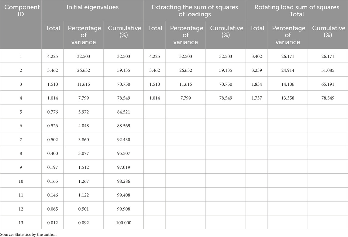
Table 7. Matrix eigenvalues and variance contribution rate of PCA.
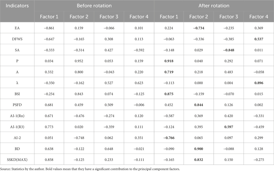
Table 8. Principal factor load matrix of local SiMAs quantitative indicators.
4.4 Agglomerative Hierarchical Clustering (AHC) and typologies
The hierarchical clustering heatmap of 51 SiMAs samples in study area obtained a cluster pedigree diagram (Figure 6). The pedigree diagram divides the samples into three categories and four subcategories. After multiple data adjustments, this study found that this classification result is the most ideal summary of the geographical distribution and morphological characteristics of the SiMAs, and the ethnic division is the clearest. The similarity of each sample in the same cluster is high, and the differences between samples in different clusters are significant. Type 1–3 are small-scale discrete settlements in hilly terraces, large-scale discrete Tibetan settlements in terrace river valleys, and dense hydrophilic settlements on gentle slopes in river valleys. Type 1 is divided into two subcategories, namely, Tibetan settlements on gentle slope terraces on the plateau and clustered Tibetan settlements on steep slopes in shallow hills. Type 3 is divided into two subcategories, namely, multi-scale ethnic symbiotic settlements on gentle slope plains and high-density clusters of Salar and Hui settlements on gentle slope terraces.
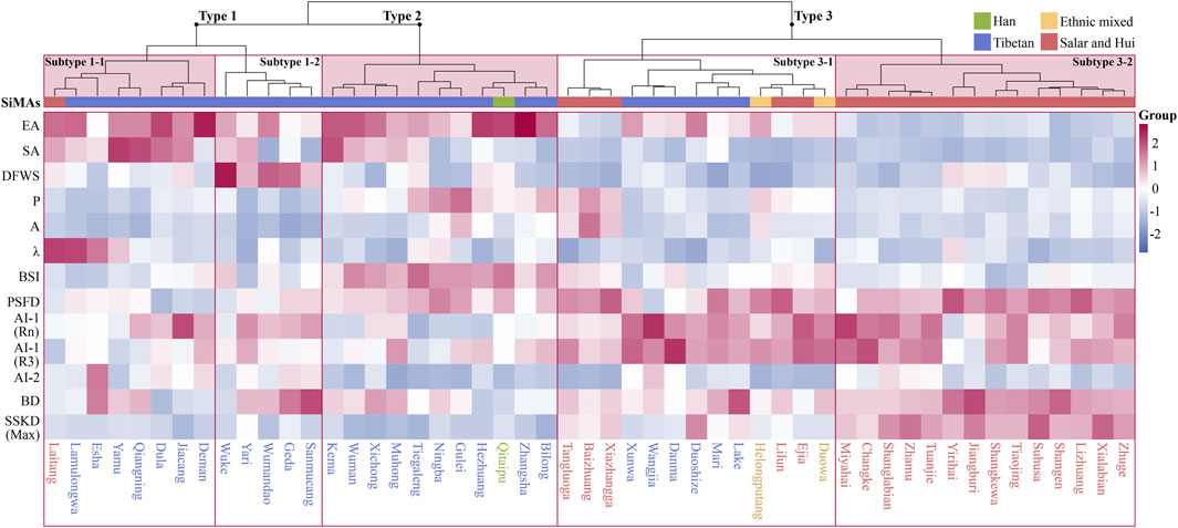
Figure 6. Hierarchical clustering heatmap of 51 SiMAs samples (image source: drawn by the authors).
Through qualitative analysis, the researchers tested the morphological correlation between the clustering results and the geographical environment and spatial structure of the settlement. We found that the classification of settlement types is not only related to the two-dimensional morphological structure but also highly correlated with the three-dimensional geographical environment. The relationship between mountains and water plays a key role in the classification of settlement morphological types. This morphological typology division is conducive to further insight into the spatial organization paradigm of different types of settlements.
4.5 Different types of representative settlement spaces
The settlement types of three categories and five subcategories show the adaptability to the geographical environment and the national wisdom of settlement space practice. With the decrease of altitude and the relaxation of terrain, the overall organizational logic of SiMAs in the region is “steep slope dispersion-gentle slope elasticity-river valley aggregation,” and its road network structure shows the layout change of “topography dominance-flexible expansion-religious centripetal.” The cultural characteristics of different ethnic groups have a significant impact on the recognition of settlement forms.
4.5.1 Type 1: small-scale settlements on hilly terraces
Most of these settlements are located in the high-altitude shallow hill area (Qianshan) and plateau hill area (Naoshan). The distinctive features of these settlements include their location in the mountains and the presence of steep slopes. This feature means the settlements tend to follow the terrain, so they are less structured and dense. These settlements are often limited to narrow plots between mountains, forming a compact and flexible spatial combination pattern under limited natural resources (Figure 7). It reflects the adaptation of living space to the ecological pattern.
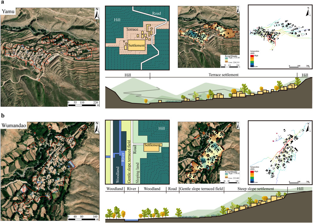
Figure 7. Characteristics of spatial composition patterns of small-scale settlements on hill terraces: (a) Subtype 1-1: Tibetan settlements scattered on the gently sloping terrace; (b) Subtype 1-2: Tibetan settlements clustered on steep slopes in shallow hill (image source: drawn by the authors).
4.5.1.1 Subtype 1–1: Tibetan settlements scattered on the gently sloping terrace
Most of the settlements in this cluster are Tibetan, with only one Salar Hui settlement. Like Tibetan settlements, they share a mountainous surround and water separation. These settlements are located at a high altitude and in a remote area, mostly on gently sloping terraces near the mountainside or ridge. This terrain greatly increases the cost of living for residents and limits the scale and form of settlements. The settlement road network is a Z-shaped structure that rises along the contour lines and is differentiated into a tree-shaped structure, reflecting the layout adaptation to the hilly terrace environment. The terrain has less impact on the settlement’s architectural layout. The settlement’s distribution is free and flexible, characterized by relative discreteness and a dotted pattern. This condition also leads to the fragmentation of settlement boundaries and the weakening of spatial structure. Yamu is a typical settlement of this type (Figure 7a). Its road network is developed along the mountain road, with branches formed in a tree-shaped structure and “Z”-shaped ramps connecting the upper and lower parts. Buildings are arranged in a strip-shaped pattern with single groups as the main feature, following the contour lines.
4.5.1.2 Subtype 1–2: Tibetan settlements clustered on steep slopes in shallow hill
All these settlements are Tibetan, and most are situated in the shallow hill area known as Qianshan, which has a significant slope. The terrain of different settlements varies greatly. This type of settlement is characterized by leaning against the mountain, facing the water but not close to the water. This construction method can not only effectively avoid floods but also ensure the convenience of water collection. At the same time, it can effectively block the northern cold current in high-altitude areas. The construction land is tight under the terrain restrictions. The road network is mainly grid-shaped, supplemented by tree-shaped structure branches to connect the various building units. The tight land use has led to the formation of a layered group development pattern in the building layout, which has prompted the settlement to present a relatively flat strip boundary form. It relies on the advantageous relationship between mountains and water to form a large-scale spatial layout, showing the organic integration of ecology and life. The characteristics of being surrounded by mountains on many sides have led to the concentration of settlement buildings on small plots, and the spatial texture is relatively homogeneous. For example, Wumandao is located on a steep slope terrace sandwiched between mountain ridges (Figure 7b). It has only one main road leading to the village, and the traffic routes are spread out in a tree-shaped manner and connected in a series to form a network. The layout of the buildings follows the undulating terrain, showing the coexistence of large clusters and small groups. The white pagoda of Tibetan Buddhism is located at the outer boundary of the village.
4.5.2 Type 2: large-scale dispersed Tibetan settlements on shallow hill terraces
Except for one Han settlement, all settlements in this subtype are Tibetan settlements. Altitude is an important basis for its classification. Most settlements are located at the intersection of the large, undulating plateau region (Naoshan) and the small, undulating shallow hill area (Qianshan). Most settlements are located on relatively gentle large-scale slopes and small-scale valleys at the foot of the mountain, with distances varying from water. Most settlements are attached to the main roads or ring roads around the mountain, forming a relatively obvious network structure supplemented by a tree-shaped structure. Its internal buildings form multiple groups, and the degree of densification is not high. However, the spatial structure is excellent. The scale of this subtype is relatively uniform, and the boundaries of the settlements show complex finger-shaped development, with both cluster and banded tendencies. Overall, the settlements show a spatial pattern of interdependence between mountains and water.
Bilong, as a typical settlement of this type, shows a clear band-shaped tendency (Figure 8a). The settlement is located on a gentle slope between two mountains. Highways and water systems pass through it and divide the settlement into two parts. The main part of the settlement relies on the main road to create a network structure, while the road network of the smaller, discrete group exhibits a clear tree-shaped differentiation. The building units tend to be distributed in a finger-shaped manner in a continuous cluster, and the main part is relatively homogeneous in space. The pagoda is on the village’s edge, while the Mani house (or Mani Lhakang) is in the settlement center. Bilong Temple is built on high ground, separated from the village.
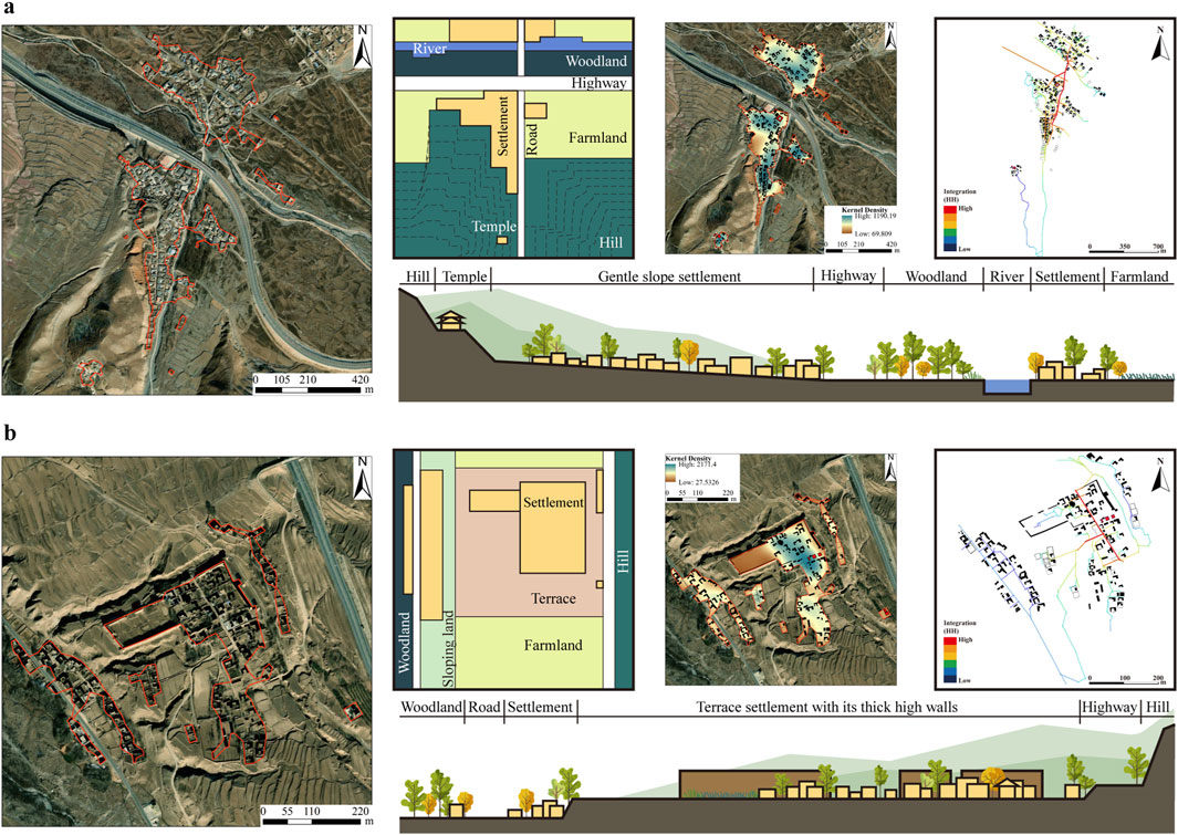
Figure 8. Characteristics of spatial composition patterns of large scale dispersed Tibetan settlements on shallow hill terraces: (a) Tibetan settlement: Bilong; (b) Han settlement: Qitaipu (image source: drawn by the authors).
Another typical case is the Han settlement Qitaipu, which was a military fortress in the Ming Dynasty (Figure 8b). At that time, it was mainly used to guard the border and prevent invasions by nomadic peoples such as the Qiang (the ancient name of the Tibetans). The settlement is on the terrace’s gentle slope, with a square layout of buildings and roads. The sacred space Guandi Temple was built next to the city wall, and the Wushan Temple was located at the commanding height in the southeast corner of the settlement. The limited land space in the fortress could not meet the growing population and housing needs, so the settlement space expanded from the inside of the broken fortress wall to the surrounding area.
4.5.3 Type 3: dense waterside settlement in gentle slope of river valley
The settlement samples in this category account for more than half of all settlement samples. The settlements are located in the low-altitude shallow hill area (Qianshan) and the valley plain area (Chuanshui). The terrain is gradually gentle. The gentle terrain promotes the development of settlement scale and the improvement of spatial structure. The settlements are mainly composed of Salar and Hui people, with Tibetans and Han people as a minority. This category also shows the integration and symbiosis of settlement space units and ethnic cultures among various ethnic groups.
4.5.3.1 Subtype 3–1: multi-scale ethnic coexistence settlements on gentle slopes and plains
This subtype of settlements shows the ethnic collision and integration adaptation of local SiMAs over a long period of time. This subtype is mostly composed of Salar and Hui settlements, as well as Tibetan settlements and ethnically mixed settlements. The scale of settlements varies. They are mainly distributed in the gentle slope plain area of the Shallow Hill area (Qianshan), close to the river. The gentle terrain has little restriction on the scale of settlement form. The settlements can expand their land use scale in multiple directions, showing finger-shaped characteristics. The degree of spatial concentration is also constantly improving, forming a clear and definite texture structure. The settlement road network is mostly attached to one side of the main road, and the road network is free and flexible, forming an irregular network structure. The settlement space is highly accessible. The convenience of transportation and water collection and the gentle terrain have significantly improved the quality of life of this subtype of settlements, which is the internal driving mechanism for the expansion of settlement scale and structural integrity.
Helongputang, a mixed ethnic settlement, is representative (Figure 9a). It is mainly inhabited by Tibetans, Hui people, and Salar people, supplemented by Han people. It is divided into two parts, north and south. Tibetans and Han people live in the southern part of the settlement on a gentle slope with higher terrain. Salar and Hui people live in the flat northern part of the settlement. The building density in the Tibetan and Han areas is relatively loose. In the Salar and Hui neighborhoods, the building layout is rather condensed. The main road organically integrates the settlement space and connects them together to facilitate the transportation and communication of multiple ethnic groups in the settlement. The village roads run parallel to the main roads, connecting in series to form a network. The sacred spaces of different ethnic groups (Buddhist temples and white pagodas, Islamic mosques) stand at the intersection of the north and south parts of the settlement.
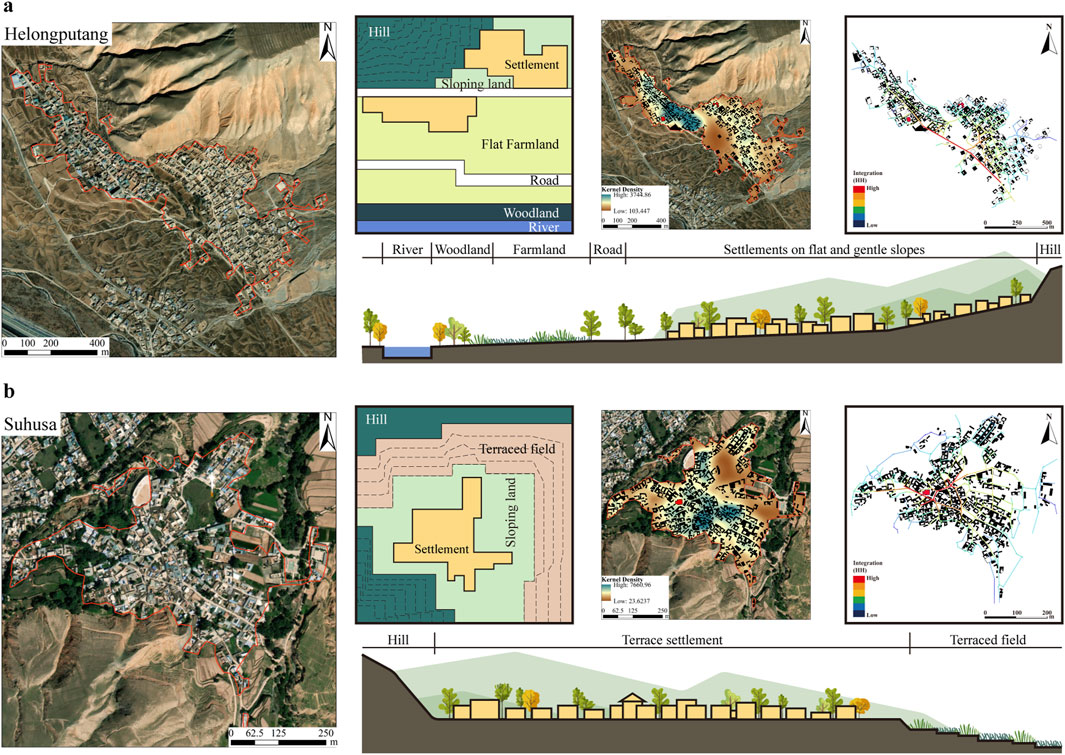
Figure 9. Characteristics of spatial composition patterns of dense waterside settlement in gentle slope of river valley: (a) Subtype 3–1: Multi-scale ethnic coexistence settlements on gentle slopes and plains; (b) Subtype 3–2: High-density clustered settlements on gentle slope terraces (Salar and Hui) (image source: drawn by the authors).
4.5.3.2 Subtype 3–2: high-density clustered settlements on gentle slope terraces (Salar and Hui)
All the settlements of this type belong to the Salar and Hui ethnic groups. Their settlement style is distinct, and their appearance is uniform. The settlements in this cluster are generally located on the gentle slope terrace at the foot of the mountain and the flat area of the river valley. The settlement distribution transitions from the shallow hill area (Qianshan) to the valley plain area (Chuanshui). The outstanding features are strong hydrophilicity, moderate scale, and compact clustered form. The settlement road network layout is flexible and diverse with high accessibility, and it is in three styles: circular radial, tree-shaped bifurcated, and mesh. The settlement building density is high, and the structure is highly orderly. This is especially reflected in the degree of densification in the hotspot area. The sacred space is located between multiple building density areas in the core position of the settlement. Suhusa is one of the representative settlements (Figure 9b). The settlement is built against the mountain and is located on a gentle slope terrace. Its spatial layout takes the mosque as the origin, forms a scattered ring structure to the periphery, and expands in a finger-shaped manner according to the contour lines. The buildings present a compact and orderly centripetal layout.
4.6 Diagram of SiMAs’ spatial genetic type
Combined with the summary of morphological types and analysis of typical cases in the above content, we created a detailed map showing the different types of local SiMAs in the Gansu-Qinghai Plateau (Figure 10). This map shows the spatial characteristics of different SiMAs types, which help researchers and planners to intuitively distinguish their heterogeneous characteristics. In addition, the map also provides visual support for in-depth understanding of the multi-level spatial organization laws of SiMAs.
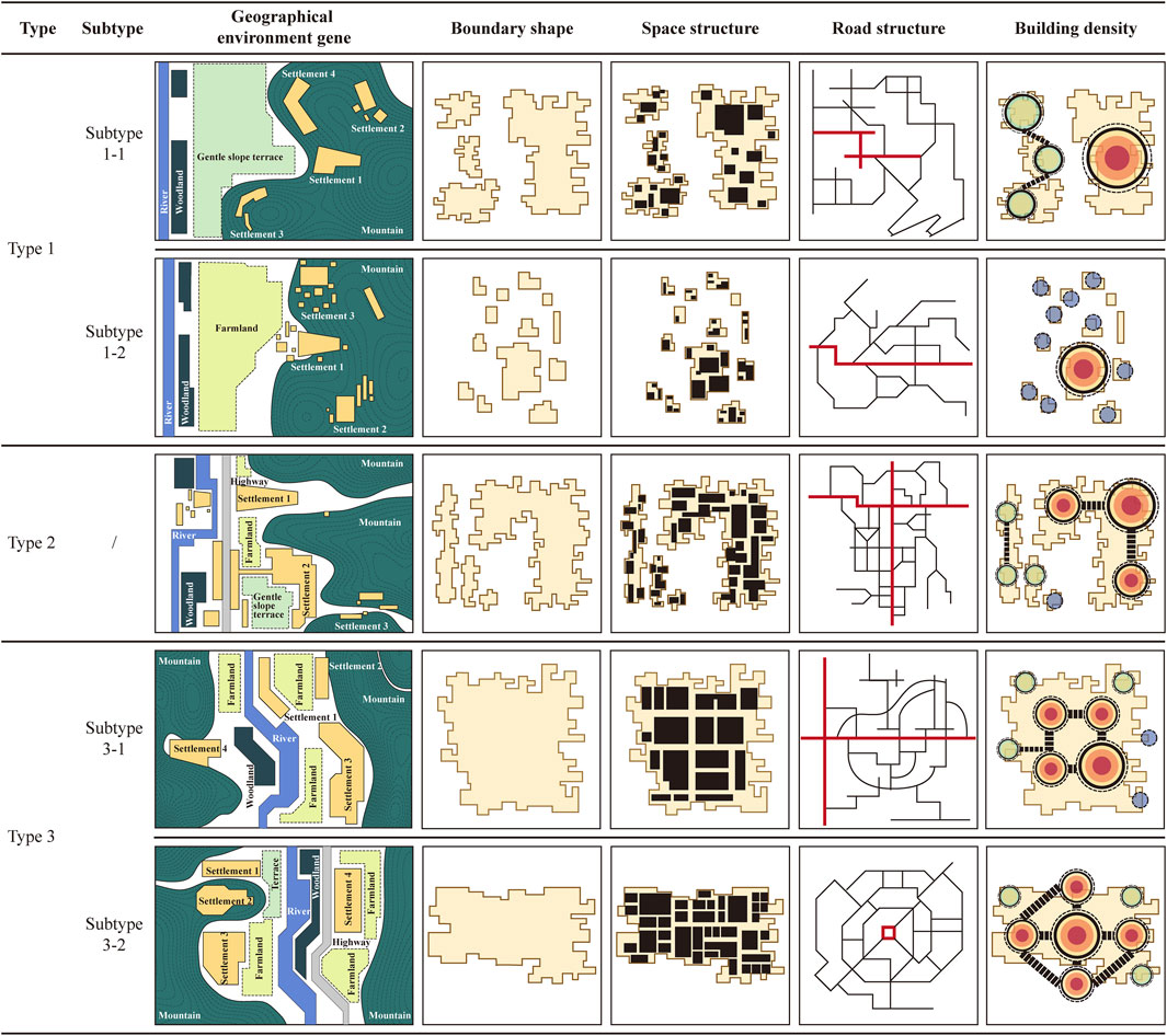
Figure 10. Different SiMAs diagram of spatial derivative types (image source: drawn by the authors).
The main population of SiMAs of type 1 and type 2 is Tibetan. In terms of spatial organization, building on the slope and choosing high places are their typical spatial patterns. Their spatial structure is relatively dispersed, with diverse layout forms, and the scale of settlements gradually increases as the terrain becomes gentler. Type 3 is divided into two subtypes, among which subtype 3-1 is the type interval where Tibetans, Han, Hui, and Salar peoples merge and intersect. Tibetans adapt to the site selection patterns of Han, Hui, and Salar peoples, living at the foot of the mountain and building near the water. Han people spread their traditional production model of intensive farming to other ethnic groups, especially Tibetans. Hui and Salar people infiltrated the structuring and orderliness of their settlement space forms into settlements of other ethnic groups. This illustration shows the mutual adaptation and integration of different ethnic groups in ethnically mixed areas. Subtype 3-2 SiMAs are Hui and Salar gathering areas. The typical spatial pattern of their settlements features finger-shaped development, which is located near water and roads. The spatial layout of their settlements is compact and highly structured. This layout demonstrates the high community cohesion and cultural identity of the Hui and Salar ethnic groups.
5 Discussion
This study conducts in-depth discussions around the three research questions raised in introduction and responds to and contributes to them in different chapters (Table 9). For Research Question 1, through mathematical and statistical analysis of 10 quantitative indicators, four main component factors and five morphological types are obtained, providing example support for the subsequent analysis of the generation mechanism of the settlement system. In Research Question 2, the relationship between sacred and secular space and the morphological generation mechanism are deeply analyzed to reveal the dominance of morphological generation and the priority of morphological inheritance of sacred beliefs. This paper promotes the dialectical unity of multi-dimensional factors in morphological typology research and provides a systematic theoretical basis for subsequent research and planning suggestions. For Research Question 3, the “paradigm” extraction realizes the upgrade from morphological classification to “organizational relationship interpretation” and accurately summarizes the local generation law of SiAMs. It provides a replicable framework for morphological typology research in theory and a reference for local SiMAs planning in practice.
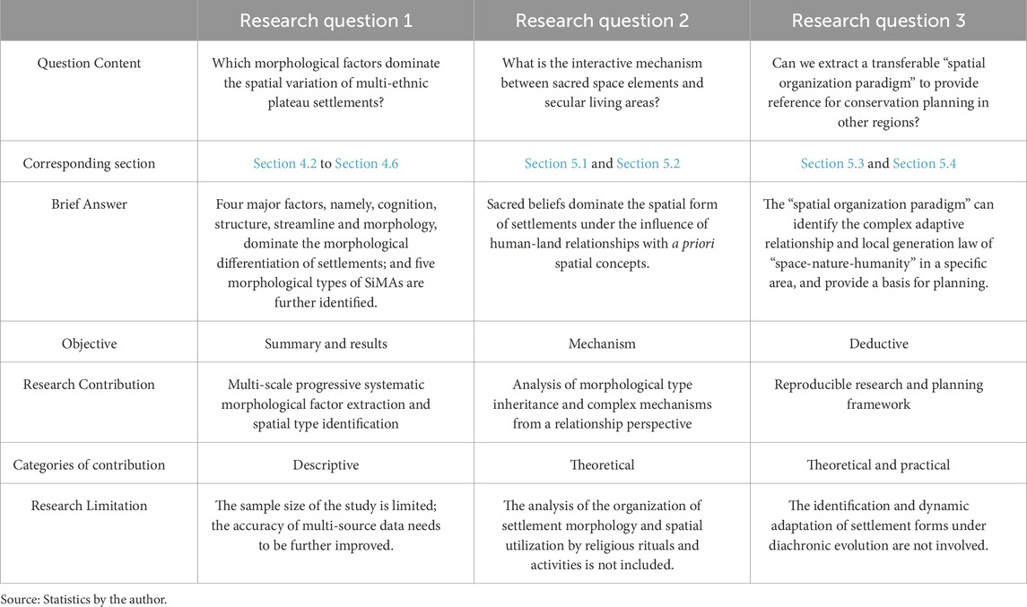
Table 9. Summary of research questions, relevant answers, research contributions and conclusions.
5.1 The relationship between the sacred and the secular in local SiMAs
5.1.1 Relationship between sacred and secular space: a priori association or layout
Based on the morphological analysis of secular space using quantitative indicators, the mechanism of the sacred-secular spatial connection further reveals the spatial patterns (principles) driven by humanities. The quantitative results provide a more comprehensive morphological feature and objective premise for the analysis of the mechanism (the “nature-space” relationship). The arrangement of SiMAs in the Gansu-Qinghai Plateau shows how religious spaces are planned from above while everyday living spaces are created from the ground up (Figure 11). Its spatial organization mode is a physical mapping of the coupling of orderliness (religious planning) and randomness (self-organization of life). The settlements and religious buildings contain a priori spatial concepts at the beginning of their construction, and residents spontaneously build courtyard dwellings to meet their living needs.
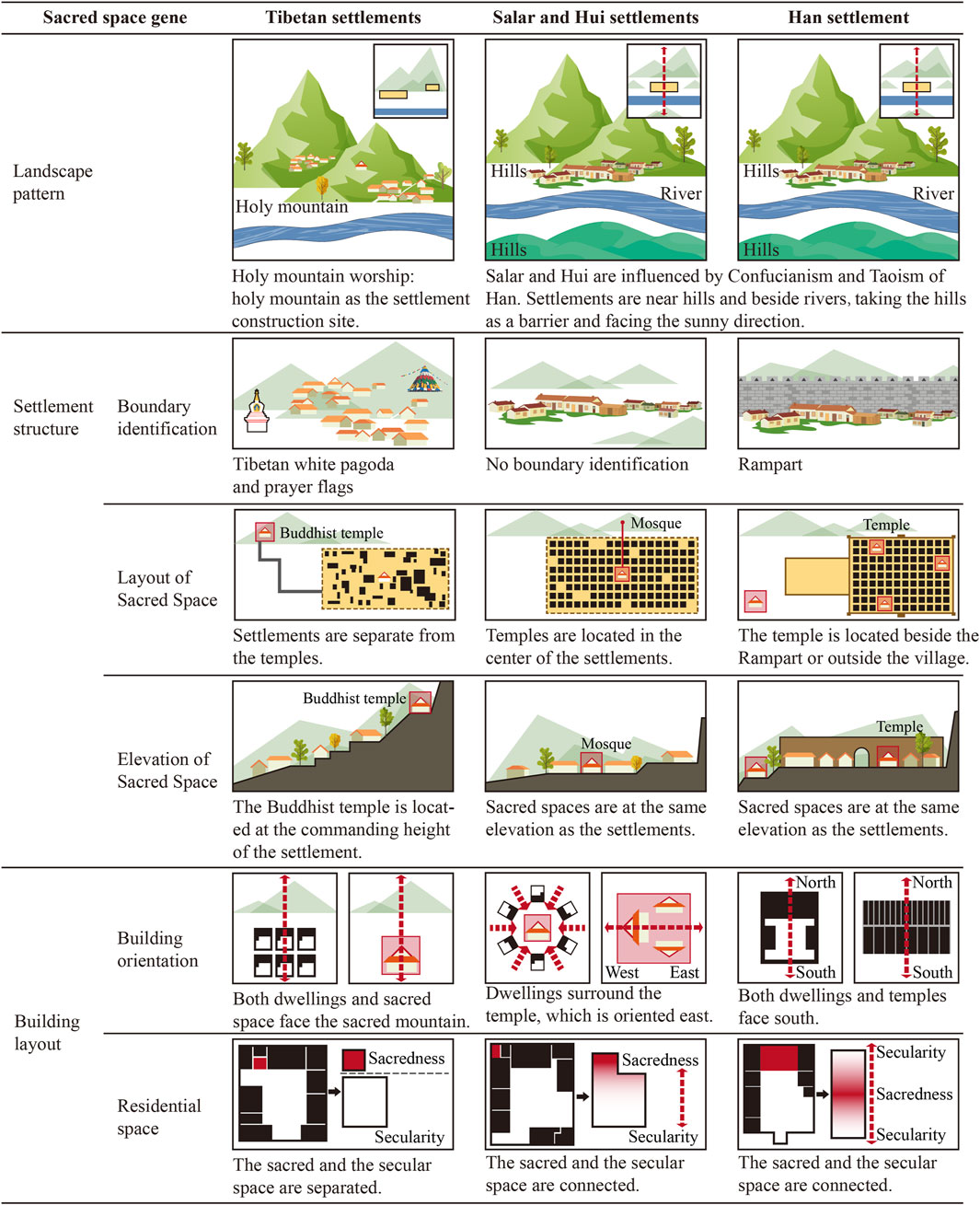
Figure 11. The relationship between sacred and secular space in SiMAs at multiple scales (image source: drawn by the authors).
Tibetan settlements present a dual relationship of coexistence and separation of the sacred and the secular. Their forms are usually characterized by high mountains and distant waters, small scale, low density and loose structure, and are deeply influenced by Tibetan Buddhism and Bon religion. At the macro level, “sacred mountain worship” constitutes the core belief. The sacred mountain and lake space protect the secular living space, and the settlements and religious building foundations are all facing the sacred mountain. At the meso level, Tibetan Buddhism has a significant transcendental characteristic. Buddhist temples are mostly located on high ground far away from the village, forming a typical pattern of “temples above and villages below,” and the connecting paths are also endowed with sacredness. Sacred symbols, such as white pagodas, mani piles, and prayer flags, scatter throughout the settlement space, acting as anchors and symbols of sacred activities. At the micro level, the village dwellings radiate outward with the courtyard building and the greenhouse as the center, and the main house or the door of the house often faces the sacred mountain; the scripture hall, as a necessary sacred space, is mostly adjacent to the main room and is independently separated. In general, the sacred space of the Tibetans is independent of secular life in most situations.
Han settlements embody the “unity of man and nature” and ritual order, with regular shapes, clear axes, and high spatial accessibility. In terms of settlement layout, the Feng Shui concept of “back to the mountain and face the water, with the yin behind and the yang in the embrace” is followed; historically, most of them were military settlements, and their religious buildings (often located in a corner of the city wall) mainly undertake the functions of comforting the soul, gathering thoughts, and worshipping, and are closely related to secular space. At the dwelling unit level, the spatial orientation is clearly defined, with houses facing north and south, emphasizing a central axis order; the main house is situated at the end of this axis, making it the most important ritual space. This layout deeply reflects the relationship between heaven and man and the order of human relations and is a spatial concrete expression of traditional rituals and patriarchal systems.
Influenced by both Han rituals and Islamic culture, Salar and Hui settlements are often located in lowlands near water, with high building density and strict spatial order. Islam prioritizes worldly practices and the unification of sacred faith and secular life. The mosque, serving as the focal point for periodic collective worship, typically locates itself in the settlement’s area with the highest traffic accessibility. It strongly radiates the spatial generation and morphological development of the settlement, forming a distinct “surrounding the temple and living” centripetal model. Both the houses and the mosques face eastward, towards the Islamic holy city of Mecca. The meditation rooms in the dwellings are often connected to the bedrooms or the main house, and the courtyard buildings are planted with flowers and trees, reflecting the characteristics of naturally integrating sacred rituals into daily life. The settlement is linked by blood ties and takes religion as its spiritual center, and the spatial organization is significantly centripetal.
5.1.2 Spatial narrative of the sacred and secular coupling
Principal component analysis (PCA) as a quantitative method disproves the dominance of sacred belief as a priori spatial concept in the formation of settlement spatial morphology and points out four major morphological generation factors that contribute to spatial differentiation under different construction concepts of multiple ethnic groups: morphological cognition, structural order, traffic layout, and boundary shaping. Its spatial narrative reflects the spatial translation of ethnic cultural genes, belief systems, and social structures under the adaptation of geographical environment and continuously strengthens ethnic identity and cultural inheritance through the organizational logic of spatial morphology. Among them, morphological cognition factors and boundary-shaping factors dominate the macro-morphological scale and spatial recognition of settlements. The rigid constraints of the geographical environment limit the maximum spatial scale and fragmentation of settlements. For example, the site selection patterns of Tibetans choosing to live in the mountains, Han people facing the mountains and facing the water, and Salar and Hui people living by the water have strengthened their own unique geographical constraints, resulting in non-ideal settlement forms such as small scale, fragmentation, and high aspect ratio. Such behavior leads to a decrease in the clarity and readability of the spatial structure. As a result, it is difficult for the overall morphological image to form a unified cognition in a complex mountain environment.
The structural order factor reflects the orderliness and density of the internal structure of the settlement. Different ethnic groups form different spatial layouts based on priori spatial concepts. Tibetans present temples above and villages below, Hans have a regular axis, and Salars and Huis have a centripetal layout. Religious beliefs have materialized in the concrete space of the settlement through social production practices, regulating the behavior of believers and cohesion of society, and shaping the settlement form with the sacred spiritual core as an abstract prototype.
The traffic layout factor reflects the spatial accessibility efficiency under terrain adaptation. The slope divides the settlement space into elevation units, and the adaptive adjustment of the road network is difficult to overcome the cross-unit traffic resistance, especially under steep terrain; it is difficult to form a networked system layout with few branch expansion roads. The tree-shaped and Z-shaped nonlinear structure also increases the complexity of connection. Tibetans place sacred spaces in low-accessibility locations due to religious needs, while Hui and Salars optimize the location of mosques and road networks to achieve high accessibility, reflecting the choice of different ethnic groups between “sacred faith” and “secular convenience.”
5.2 The morphogenesis mechanism of SiMAs under the interaction of multi-factors
The above-mentioned “quantitative-qualitative” analysis has improved the “people-land-settlement” relationship framework and promoted this study. On the basis of recognizing and supporting the two previous viewpoints of geographical constraints (Ruggiero et al., 2019; Zhang et al., 2023; Li et al., 2023) and humanistic spirit drive (Moudon, 1989; Gunawan et al., 2023), this study further explored the settlement morphology generation and sacred-secular relationship mechanism of SiMAs in the Gansu-Qinghai Plateau under the synchronous spatiotemporal cross-section, promoting the systematic cognition and development of ethnic settlement morphology. The spatial pattern of the SiMAs is the synchronous product of the nonlinear interaction of multiple subjects, the natural environment, and social culture. Multiple subjects (ethnic communities, government forces) endow settlements with dynamic evolution capabilities through adaptive transformation. The natural environment (landform, water bodies, vegetation) as a rigid ecological substrate not only provides material carriers but also imposes spatial constraints. Social culture (religious rituals, folk norms) constructs cultural identity and social cohesion. The three form a complex adaptive system through collaborative self-organization. In this mechanism, religious sacredness becomes the core link of spatial organization, driving the formation of a “spatial magnetic field” with religious buildings or sacred images as the spiritual core (Figure 12). The settlement develops in accordance with the inward order of “single/multiple sacred nodes controlling the surface form.” The sacred space anchors the settlement boundary, and religious rituals strengthen the geopolitical structure and domain awareness, significantly enhancing the sense of community belonging and security. At the same time, the settlement maintains the system balance through dual adaptive regulation: on the one hand, residents actively match geographical elements (such as mountain shape and water potential) with sacred symbols in ideology, condense the regional spirit of the trinity of “human-god-nature,” and shape a unique view of nature and values. On the other hand, the settlement form is deeply isomorphic to the natural environment, which is manifested in the topological adaptation of the spatial pattern to topography, hydrology, and other elements. This regulation fosters a dynamic coupling between religious order, residents’ self-organization, and environmental isomorphism. Additionally, internal factors such as religious culture and social production, along with external factors like geopolitical relations and natural constraints, spontaneously generate an ordered structure through nonlinear interactions. Any change in a factor can disrupt the current equilibrium and initiate the system’s adaptive evolution. This evolution shows changes in how space is organized and how social and ecological relationships are rebuilt, which helps the SiMAs system create a new balance between cultural heritage and sustainable development.
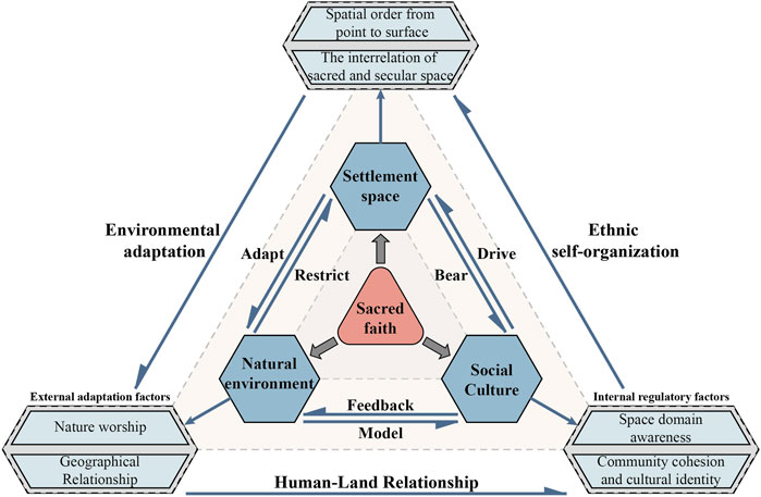
Figure 12. Morphological generation mechanism of SiMAs under multi factor coupling interaction (image source: drawn by the authors).
5.3 Research innovation and universal application
This study innovatively proposed a “spatial organization paradigm” based on morphological typology, breaking through the dual limitations of previous studies: first, it transcends the traditional static description of material form itself or the analysis of the driving mechanism of a single factor (Shi et al., 2022; Masoumi et al., 2019). Second, it abandons the simplified cognition of “geographic determinism” (Ji et al., 2022). This paradigm summarizes the morphological types and sacred images of SiMAs in study area based on four major morphological factors. The atlas paradigm constructed in this way objectively incorporates spatial cultural perception into the judgment framework of morphological types, clarifies the construction attributes of cultural significance, and reveals the complex adaptive relationship and local generation law of the “space-nature-humanity” system in a specific region of the Gansu-Qinghai Plateau. Its core contribution lies in analyzing the interactive order of multiple factors under synchronous morphological differentiation—the natural environment constitutes a rigid foundation, and social humanities (especially religious sacredness) as a subjective driving force drives spatial self-organization, and the dynamic coupling of the two shapes the concrete morphology of the aggregation. The study found that although the settlements in southern China (Yuan and Jiang, 2024) and southwestern Indonesia (Muda et al., 2022) also show the characteristics of the interweaving of the sacred and the secular, their core driving force is clan blood rather than religious sacredness, highlighting the uniqueness of the spatial pattern dominated by religious beliefs in Gansu and Qinghai SiMAs. In addition, the morphogenetic priority proposed by the Conzenian school was visualized as a priori organization of the sacred space magnetic field in this study. This theory explains “how space is carried by history”, and the sacred space magnetic field reveals how the settlement space is reshaped by meaning from the perspective of humanistic spirit. The integration of the two enables morphological typology research to truly touch the essence of settlement organisms.
At the methodological level, this study combines a multi-scale geometric model with qualitative research and uses mathematical statistics to objectively identify settlement morphological types. The complementary synergy of quantitative and qualitative non-substitutability helps to break the subjectivity of empirical description in qualitative research (Wang et al., 2005) and improve the comparability between different morphological types. This study breaks through the limitations of traditional quantitative research (Lagarias and Prastacos, 2020; Shen and Fan, 2024), which is one-sided and single-perspective, and introduces a multi-scale and multi-geometric model to comprehensively analyze the material space of the settlement, providing an objective yardstick for the qualitative judgment of “sacred dominance” and “sacred and secular interweaving”, and enhancing the transferability of the conclusions. At the theoretical level, the paradigm focuses on “morphological inheritance and derivative mechanisms of multi-factor associations in the construction process”, which promotes the shift of morphological typology from material space analysis to cultural space interpretation and provides empirical support for the dialectical relationship between “space-nature-humanity”. This has promoted the transformation of the perspective of morphological typology research from “built results” to “construction process and interactive relationship”. In addition, it also requires that morphological typological research must place local cultural logic at the core of analysis and deny the “decontextualized” universal type induction. This “nature-humanity-space” relationship framework has significant universal value: it can explain the logic of settlement morphology generation in regions with complex terrain and diverse cultures around the world (Figure 13), such as the mountain adaptation of Miao and Dong settlements in Guizhou, China (Zheng et al., 2022), the landscape synergy of the Medieval town in the Wachau Valley, Austria (Riedl et al., 2022), and the religious organization of the traditional vernacular settlements in Hadramaut Governorate, Yemen (Leiermann, 2021). This framework offers a universal tool for extracting the prototype of settlement space organization, which aids in achieving coordinated protection of both physical heritage and intangible civilization within the context of globalization. It particularly supports planning theory for regions affected by modernization, considering both cultural continuity and sustainable development.
Figure 13. Research subjects with similar geographical or cultural conditions (image source: drawn by the authors).
5.4 Planning inspiration and suggestions
In order to promote the sustainable development of SiMAs in the Gansu-Qinghai Plateau, the paradigm map constructed in this study provides a planning path for the protection of settlement heritage, considering both the inheritance of sacredness and the adaptation to modernization. The map clarifies the core characteristics and sensitive elements of different settlement types, such as the Tibetan “upper temple and lower village,” the Salar and Hui “living around the temple,” and the Han “ritual system” core. Specific planning suggestions are as follows: First, implement the “core-buffer” double-circle land use control mechanism (Fan et al., 2025), delineate the protection boundary in space, and include religious buildings and traditional residential clusters into the core protection area to maintain their adaptability and functional integrity. The buffer coordination zone is set up on the periphery to maintain the integrity of sacred images, visual corridors, and historic environments through gradient control. For example, Tibetan settlements with separate sacred and secular locations, such as Bilong, should maintain the sacred spatial order and sacred-secular relationship of their religious buildings based on the original landscape pattern. The secular space of their settlements should focus on the coexistence of multiple functions and reasonably organize the folk space sequence. Second, promote the embedding of “sacred axis” into the statutory plan of village planning (Liu et al., 2022), and mark the Tibetan pilgrimage route, Hui worship direction line, Han ritual axis, etc., as mandatory spatial control elements. For example, optimize the connection of spatial nodes such as mosques, Buddhist temples, white pagodas, and squares as carriers of folk activities; constrain the distance between buildings; and maintain interface continuity and business development through special land use coding. Third, promote the adaptive renewal of courtyard compound architecture units, repair historical residential buildings to continue the courtyard layout and rural style, and innovate the use of building materials and rammed earth technology (Zhang et al., 2018). For example, under the premise of respecting the differentiation characteristics of sacred and secular spaces, improve the performance of insulation, lighting, ventilation, etc., according to the needs of modern life, and realize the sustainable regeneration of traditional spatial structures. Fourth, implement the bottom-up planning of multi-subject collaboration at the same time, guide villagers to participate in independent construction, call on the government to incorporate the control of sacred axes into the national land space planning, coordinate the interests and development of multiple parties, and enterprises need to coordinate economic interests with the protection of local cultural ecology.
5.5 Limitations
The limitations of this study are mainly reflected in three aspects: (1) There are constraints on sample size and data accuracy. The insufficient number of settlement samples (especially the Han cases) may lead to the one-sidedness of the summary of SiMAs morphological characteristics; the limited accuracy of geographic data makes it difficult to analyze the morphological differences under the hidden micro-topography, and the spatial texture relies on manual mapping, which is both inefficient and inaccurate. In the future, the sample size needs to be expanded to refine the universal spatial paradigm, and the high-precision modeling of UAV LiDAR and the automatic extraction technology of machine learning should be integrated to improve data quality. (2) There is a lack of analysis of the behavioral dimension. The study focuses on the material spatial form and does not include the influence mechanism of sacred activities such as religious rituals on spatial organization. In the future, it can combine environmental behavior and anthropology methods to analyze how individual behavior in the sacred environment drives the evolution of macro space based on the Agent-Based Model (ABM). (3) The diachronic perspective is weak. The current synchronous cross-sectional analysis is difficult to reveal the logic of the dynamic evolution of morphology. In the future, we should combine Sentinel-2 images, old maps, and documents to create a historical spatial database that can help us understand how and why the shapes of these areas have changed over time. Nevertheless, this study still provides solid theoretical support for the spatial resilience and identity maintenance of mountain ethnic settlements.
6 Conclusion
This study aims to clarify how sacred and secular spatial logics jointly construct the morphology of multiethnic plateau settlements. Based on the 10-indicator type-morphological framework, 51 settlements on the Gansu-Qinghai Plateau were analyzed, and four main components, namely, morphological cognition, structural order, transportation layout, and boundary shaping, were extracted, and five settlement prototypes were summarized.
First, through PCA, four principal components were identified—Morphological Cognition, Structural Order, Traffic Layout, and Boundary Shaping—which collectively account for 78.549% of the total variance. Among them, morphological cognition and structural order together reveal more than 50% of spatial variation, showing the important role of landscape sequence in the formation of settlement morphology. Secondly, AHC classified the settlements into five distinct spatial paradigms, supported by six representative cases. These paradigms reflect adaptive strategies under specific geographical constraints and sacred beliefs, demonstrating significant morphological differentiation. The layout forms, such as the separation and coupling of sacred and secular space, the sacred layout of single buildings, and the spatial anchoring of sacred elements, are manifested as a priori organizational principles. Its role transcends ethnic differences; secular space achieves adaptive development through multi-factor coupling. Finally, sacred space serves as a fundamental and enduring organizing element that cuts across ethnic identities, whereas secular space exhibits adaptability and variability influenced by “human-land” relationship. The “spatial organization paradigm” proposed in this study extracts the sacred a priori organizational prototype and the adaptive settlement morphological type. This effectively builds a bridge between morphological typology and religious research.
Theoretically, this study expands the perspective of settlement morphology from the monoethnic lowlands to the multiethnic plateau. This study resolves the lack of discussion on the spatial linkage mechanisms between sacred and secular in existing research and further identifies the self-organizing evolutionary logic of the “people-land-settlement” settlement system. This advances morphological typology toward a new research paradigm of “multi-factor co-evolution.” In practice, the results offer an evidence-based foundation for implementing “core-buffer” land use control and integrating sacred axes into statutory village planning, which can be applied to protect and enhance the spatial resilience of multicultural cultural heritage sites in mountainous areas.
Data availability statement
The original contributions presented in the study are included in the article/Supplementary Material, further inquiries can be directed to the corresponding authors.
Author contributions
BJ: Conceptualization, Data curation, Formal Analysis, Investigation, Methodology, Resources, Software, Validation, Visualization, Writing – original draft. TJ: Conceptualization, Data curation, Formal Analysis, Investigation, Methodology, Resources, Software, Validation, Visualization, Writing – original draft. JS: Conceptualization, Data curation, Formal Analysis, Investigation, Methodology, Resources, Software, Validation, Visualization, Writing – original draft. YH: Conceptualization, Formal Analysis, Funding acquisition, Methodology, Project administration, Resources, Software, Validation, Visualization, Writing – original draft. YD: Conceptualization, Data curation, Formal Analysis, Investigation, Methodology, Resources, Software, Validation, Visualization, Writing – original draft. YC: Formal Analysis, Project administration, Supervision, Writing – review and editing.
Funding
The author(s) declare that financial support was received for the research and/or publication of this article. This research was funded by (1) the General Research Project of the Zhejiang Provincial Department of Education: “The Impact of Local Identity on Rural Settlements in the Middle Reaches of the Nanxi River and Optimization Strategies” (grant number: Y202353008); (2) the 2024 Zhejiang Provincial Philosophy and Social Science Planning “Provincial-City Cooperation” Project: “The Distribution Characteristics, Spatiotemporal Evolution, and Influencing Factors of Rural Settlements in the Nanxi River Basin from 1990 to 2020” (grant number: 24SSHZ085YB). The funders had no role in the study conceptualization, data curation, formal analysis, methodology, software, decision to publish, or preparation of the manuscript. This study received no additional external funding.
Acknowledgments
The authors are grateful to the Editor and Reviewers for their valuable comments and suggestions.
Conflict of interest
The authors declare that the research was conducted in the absence of any commercial or financial relationships that could be construed as a potential conflict of interest.
Generative AI statement
The author(s) declare that no Generative AI was used in the creation of this manuscript.
Any alternative text (alt text) provided alongside figures in this article has been generated by Frontiers with the support of artificial intelligence and reasonable efforts have been made to ensure accuracy, including review by the authors wherever possible. If you identify any issues, please contact us.
Publisher’s note
All claims expressed in this article are solely those of the authors and do not necessarily represent those of their affiliated organizations, or those of the publisher, the editors and the reviewers. Any product that may be evaluated in this article, or claim that may be made by its manufacturer, is not guaranteed or endorsed by the publisher.
Supplementary material
The Supplementary Material for this article can be found online at: https://www.frontiersin.org/articles/10.3389/feart.2025.1674493/full#supplementary-material
Abbreviations
PCA, Principal Component Analysis; AHC, Agglomerative Hierarchical Clustering; DEM, Digital Elevation Model; EA, Elevation Analysis; SA, Slope Analysis; DFWS, Distance from Water System; BSI, Boundary Shape Index; PSFD, Public Space Fractal Dimension; AI-1, Axis Integration; AI-2, Axis Intelligibility; BD, Building Density; SSKD, Sacred Space Kernel Density; CS, Clustered settlements; B-CS, Cluster settlement with banded tendencies; BS, Band-shaped settlements; C-FS, Clump-prone finger-shaped settlements; FS, Finger-shaped settlements without tendency; B-FS, Banded-prone finger-shaped settlements; ABM, Agent-Based Model.
References
Batty, M., and Longley, P. (1994). Fractal cities: a geometry of form and function. Cambridge, United States: Academic Press. Available online at: https://books.google.com.hk/books?id=gYR9QgAACAAJ (Accessed May 16, 2025).
Bryant, F. B., and Yarnold, P. R. (1995). “Principal-components analysis and exploratory and confirmatory factor analysis,” in Reading and understanding multivariate statistics (Washington, DC: American Psychological Association), 99–136.
Bu, Y., and Lai, P. (2024). Research on the morphological typology of traditional villages in the Fujiang River Basin in the multicultural interlaced area (in Chinese). Archit. J., 16–21. Available online at: https://xueshu.baidu.com/usercenter/paper/show?paperid=1u0v0mn0643w0tx0tw7t08b0rg120472&site=xueshu_se (Accessed May 16, 2025).
Burchardt, M. (2021). Creating religious spaces in cape town, Barcelona and Montreal: perspectives from cultural theory on the Re-Figuration of spaces and cross-cultural comparison. Forum Qual. Sozialforschung/Forum Qual. Soc. Res. 22, 1–31. doi:10.17169/fqs-22.2.3716
Central People’s Government of China. Resources, environment, national conditions and national strength have been accurately depicted. Available online at: https://www.gov.cn/xinwen/2017-04/25/content_5188665.htm (Accessed May 16, 2025).
Chen, F., and Grzybowski, S. (2010). Secrets of my research success: advice from the experts. Archit. J. 8, 85–90. (in Chinese). doi:10.1370/afm.1086
Chen, J., Yao, S., and Tian, Y. (2017). The theory and localization about typo-morphological approach. Urban Plan. Int. 32, 57–64. (in Chinese). doi:10.22217/UPI.2014.109
Choephel, T. (2019). Ethnographic profiling of semi Nomadic pastoral communities: a study on socio-cultural characteristics of yak herders in Arunachal Pradesh. Int. J. Res. Anal. Rev. 6, 313–332.
Cui, W., Wang, J., Yue, B., and Li, Y. (2012). A study on the renewal model of traditional dwellings in multi-ethnic areas: a case study of Zhuangkuo dwellings in Hehuang area of Qinghai. Archit. J., 83–87. (in Chinese).
Cui, X., Zhou, T., Xiong, X., Xiong, J., Zhang, J., and Jiang, Y. (2022). Farmland suitability evaluation oriented by non-agriculturalization sensitivity: a case study of Hubei Province, China. Land 11, 488. doi:10.3390/land11040488
Dear, M. J. (2001). The postmodern urban condition. New Jersey, United States: Wiley-Blackwell. Available online at: https://books.google.com.hk/books?id=mEROJ23D9ZoC (Accessed May 16, 2025).
Dubes, R. C. (1999). “Cluster analysis and related issues,” in Handbook of pattern recognition and computer vision. Singapore: World Scientific, 3–32.
Fan, L., Zhang, D., Li, X., and Shi, Y. (2025). Research on the coordinated development of traditional village protection and utilization from a centralized and contiguous perspective: taking mentougou in Beijing as an example. Chin. Landsc. Archit. 41, 79–86. doi:10.19775/j.cla.2025.04.0079
Gao, D., Cao, J., Bai, M., and Liu, J. (2024). Feasibility study on the preservation and renewal of historic districts based on urban morphological typology: taking dalian chain street as an example. Archit.Cult., 154–156. (in Chinese). doi:10.19875/j.cnki.jzywh.2024.01.049
Ghahramani, L., McArdle, K., and Fatorić, S. (2020). Minority community resilience and cultural Heritage preservation: a case Study of the Gullah geechee community. Sustainability 12, 2266. doi:10.3390/su12062266
Gizelis, T.-I., Pickering, S., and Urdal, H. (2021). Conflict on the urban fringe: urbanization, environmental stress, and urban unrest in Africa. Polit. Geogr. 86, 102357. doi:10.1016/j.polgeo.2021.102357
Gu, K. (2001). Theory and methods of urban morphology: exploring a comprehensive and rational research framework. City Plan. Rev., 36–42. (in Chinese).
Gunawan, I., Soemardiono, B., and Septanti, D. (2023). Typology of development at spatial patterns of water edge area in Malay ethnic community in pontianak. IOP Conf. Ser. Earth Environ. Sci. 1218, 012012. doi:10.1088/1755-1315/1218/1/012012
Hancock, M., and Srinivas, S. (2008). Spaces of modernity: religion and the urban in Asia and Africa. Int. J. Urban Regional Res. 32, 617–630. doi:10.1111/j.1468-2427.2008.00800.x
Harun, N. Z., Jaffar, N., and Mansor, M. (2021). The contributions of public space to the social sustainability of traditional settlements. Plan. Malays. 19, 192–205. doi:10.21837/pm.v19i19.1071
Herrán Gómez, J., Torres-Toukoumidis, Á., and Afonso Gallegos, A. (2019). Efecto de la territorialidad en la identidad andina: caso Ecuador. Rev. Estud. del Desarro. Soc. Cuba América Lat. 7, 68–87.
Hillier, B., Leaman, A., Stansall, P., and Bedford, M. (1976). Space syntax. Environ. Plan. B Plan. Des. 3, 147–185. doi:10.1068/b030147
Hua, Y., and Nakatani, N. (2025). Historic conservation in Tibetan region amidst rapid urbanization: a case study of Dukezong Old Town. J. Asian Archit. Build. Eng. 24, 1–15. doi:10.1080/13467581.2023.2287196
Huang, Y., Xia, J., Chen, Y., and Hong, J. (2024). Global research progress on rural settlement spatial patterns from 2000–2024: a comprehensive review of hotspots, frontiers, and emerging trends. Front. Earth Sci. 12, 1505570. doi:10.3389/feart.2024.1505570
Huang, Y., Huang, Y., Chen, Y., and Yang, S. (2025a). Spatial evolution of traditional waterside settlements south of the Yangtze River and the distribution of settlement heritage: evidence from the Nanxi River Basin. NPJj Herit. Sci. 13, 62. doi:10.1038/s40494-025-01649-3
Huang, Y., Huang, Y., Chen, Y., Song, J., Yang, S., Huang, L., et al. (2025b). The evolution and construction of Shan-shui cities: evidence from the ancient city of Hangzhou from the sixth to the twenty-first century via geographical information systems and space syntax. Front. Earth Sci. 13, 1551117–1552025. doi:10.3389/feart.2025.1551117
Huang, Y., Huang, Y., Chen, Y., Yan, Y., Zheng, L., and Ying, Z. (2025c). Interpretation of the jiangnan landscape and countryside (Shan-Shui) pattern: evidence from the classification and spatial form of traditional settlements in the nanxi River Basin. Buildings 15, 413. doi:10.3390/buildings15030413
Ji, Z., Xu, Y., Sun, M., Liu, C., Lu, L., Huang, A., et al. (2022). Spatiotemporal characteristics and dynamic mechanism of rural settlements based on typical transects: a case study of Zhangjiakou city, China. Habitat Int. 123, 102545. doi:10.1016/j.habitatint.2022.102545
Jiang, B., Huang, Y., Chen, Y., Lu, J., and Yang, T. (2025). The distribution pattern and spatial morphological characteristics of military settlements along the ming great Wall in the Hexi Corridor region. Buildings 15, 1136. doi:10.3390/buildings15071136
Jin, D., Runqing, S., Wenlong, L., Jinhua, L., and Ying, J. (2019). Space gene. City Plan. Rev. 43, 14–21. (in Chinese). doi:10.11819/cpr20190204a
Kamalipour, H., and Iranmanesh, A. (2021). Morphogenesis of emerging settlements: mapping incremental urbanism. Land 10, 89. doi:10.3390/land10010089
Kropf, K. (2013). Ambiguity in the definition of built form. Urban Morphol. 18, 41–57. doi:10.51347/jum.v18i1.3995
Lagarias, A., and Prastacos, P. (2020). Comparing the urban form of South European cities using fractal dimensions. Environ. Plan. B 47, 1149–1166. doi:10.1177/2399808318820911
Leiermann, T. (2021). Rehabilitation of historic Shibam and Zabid, Yemen as an impulse for community and economy. Built Herit. 5, 20. doi:10.1186/s43238-021-00044-8
Li, T., Li, C., Zhang, R., Cong, Z., and Mao, Y. (2023). Spatial heterogeneity and influence factors of traditional villages in the wuling Mountain Area, Hunan Province, China based on multiscale geographically weighted regression. Buildings 13, 294. doi:10.3390/buildings13020294
Lin, X., Zhang, Y., Wu, Y., and Yang, Y. (2024). Assessment of architectural typologies and comparative analysis of defensive rammed Earth dwellings in the Fujian region, China. Buildings 14, 3652. doi:10.3390/buildings14113652
Liu, S., Li, Y., Zhang, B., and Fan, H. (2022). Research progress and review on the application of traditional planning in China since 2000. Mod. Urban Res., 30–36. doi:10.3969/j.issn.1009-6000.2022.08.005
Ma, Z., and Ma, X. (2007). Harmony between the living space and natural environment: research on the ecological living culture of the Northwest minorities. Heilongjiang Natl. Ser., 127–131. (in Chinese). doi:10.16415/j.cnki.23-1021/c.2007.04.029
Masoumi, H. E., Terzi, F., and Serag, Y. M. (2019). Neighborhood-scale urban form typologies of large metropolitan areas: observations on Istanbul, Cairo, and Tehran. Cities 85, 170–186. doi:10.1016/j.cities.2018.09.005
Meitzen, A. (1895). Siedelung und agrarwesen der Westgermanen und Ostgermanen: der Kelten, Römer, Finnen und Slawen, 3. Berlin, Germany: Wilhelm Hertz. doi:10.1177/000271629700900313
Moser, L. J. (2019). The Chinese mosaic: the peoples and provinces of China. London, United Kingdom: Routledge. doi:10.4324/9780429309588
Moudon, A. V. (1989). The role of typomorphological studies in environmental design research. Changing Paradigms, 41–48. Available online at: https://scholar.google.com.hk/scholar?hl=zh-CN&as_sdt=0%2C5&q=The+role+of+typomorphological+studies+in+environmental+design+research.+In%3A+20th+meeting+of+the+environmental+design+research+association&btnG= (Accessed May 16, 2025).
Muda, I., Hasibuan, E. J., Siregar, M., and Pulungan, W. (2022). Harmonization village based on Dalihan Na Tolu in Sibadoar village, Sipirok District, Selatan Tapanuli Regency, Indonesia. Path Sci. 8, 4001–4007. doi:10.22178/pos.86-4
Muñoz, C. A., and Ramos, F. J. (2024). Adaptability and interconnectedness in Latin American innerburbs: an assessment of the public/private interface in informal settlements. Buildings 14, 1378. doi:10.3390/buildings14051378
Nahiduzzaman, K. M., Aldosary, A., Ahmed, S., Hewage, K., and Sadiq, R. (2020). Urban cohesion vis-à-vis organic spatialization of “Third places” in Saudi Arabia: the need for an alternative planning praxis. Habitat Int. 105, 102258. doi:10.1016/j.habitatint.2020.102258
Nianxing, Y. (2009). Symbiotic attribute and symbiotic logic of ethnic group. Guangxi Ethnic Studies, 50–56. (in Chinese). doi:10.3969/j.issn.1004-454X.2009.04.009
Nie, Z., Li, N., Pan, W., Yang, Y., Chen, W., and Hong, C. (2022). Quantitative research on the form of traditional villages based on the space Gene—A case Study of Shibadong village in Western Hunan, China. Sustainability 14, 8965. doi:10.3390/su14148965
Nie, X., Xie, Y., Xie, X., and Zheng, L. (2022). The characteristics and influencing factors of the spatial distribution of intangible cultural heritage in the Yellow River Basin of China. Herit. Sci. 10, 121. doi:10.1186/s40494-022-00754-x
Park, R. E. (1925). The City. Chicago, United States: University of Chicago Press. Available online at: https://books.google.com.hk/books?id=AKdMAAAAMAAJ (Accessed May 16, 2025).
Philokyprou, M., and Michael, A. (2021). Environmental sustainability in the conservation of vernacular Architecture. The case of rural and urban traditional settlements in Cyprus. Int. J. Archit. Herit. 15, 1741–1763. doi:10.1080/15583058.2020.1719235
Rahbarianyazd, R. (2020). Typo- morphological analysis as a method for physical revitalization: the case of Famagusta’s residential district. Proc. Int. Conf. Contemp. Aff. Archit. Urbanism-ICCAUA 3, 264–276. doi:10.38027/N262020ICCAUA316381
Riedl, D., Roetzel, R., Pöppl, R. E., and Sprafke, T. (2022). “Wachau world Heritage site: a diverse riverine landscape,” in Landscapes and landforms of Austria. Editor C. Embleton-Hamann (Cham: Springer International Publishing), 163–178.
Ruggiero, G., Parlavecchia, M., and Dal Sasso, P. (2019). Typological characterisation and territorial distribution of traditional rural buildings in the Apulian territory (Italy). J. Cult. Herit. 39, 278–287. doi:10.1016/j.culher.2019.02.012
Shen, P. (2011). The application of urban morphology typology in the protection and renewal of historical blocks: a case study of the “one river and two banks” area in Changjing Town, Jiangyin City (in Chinese). China Homes, 10–11. Available online at: https://www.zhangqiaokeyan.com/academic-journal-cn_china-homes_thesis/020123829355.html (Accessed May 16, 2025).
Shen, Z., and Fan, Y. (2024). Morphological characteristics of Yao nationality rural settlement boundary in nanling corridor. Guangdong Landsc. Archit. 46, 73–79. (in Chinese). doi:10.12233/j.gdyl.2024.02.011
Shi, Z., Ma, L., Zhang, W., and Gong, M. (2022). Differentiation and correlation of spatial pattern and multifunction in rural settlements considering topographic gradients: evidence from Loess Hilly Region, China. J. Environ. Manag. 315, 115127. doi:10.1016/j.jenvman.2022.115127
Siwi, S. H., Yatmo, Y. A., and Atmodiwirjo, P. (2020). Maintaining social sustainability through the boundary Formation of sacred spaces in moslem dwellings. Int. J. Technol. 11, 133–319. doi:10.14716/ijtech.v11i1.3764
Stevens, Q., and Thai, H. M. H. (2024). Mapping the character of urban districts: the morphology, land use and visual character of Chinatowns. Cities 148, 104853. doi:10.1016/j.cities.2024.104853
Thinh, N. K., and Kamalipour, H. (2022). The morphogenesis of villages-in-the-city: mapping incremental urbanism in Hanoi city. Habitat Int. 130, 102706. doi:10.1016/j.habitatint.2022.102706
The State Council. Comprehensive rural revitalization plan (2024–2027) issued by the Central Committee of the Communist Party of China and the. Beijing: State Council. Available online at: https://www.gov.cn/gongbao/2025/issue_11846/202502/content_7002798.html (Accessed May 15, 2025).
Tian, Y., Gu, K., and Tao, W. (2010). Urban morphology and conservation planning. City Plan. Rev. 34, 21–26. (in Chinese).
Tu, S., and Long, H. (2020). The theoretical cognition of rural settlements spatial restructuring. Geogr. Sci. 40, 509–517. doi:10.13249/j.cnki.sgs.2020.04.002
Tutuko, P., Bonifacius, N., Yuniawan, D., and Jati, R. M. B. (2021). Measuring spatial arrangement of Indonesian colonial cities using depth and connectivity calculations: ratio study on master plans using space syntax. Int. Rev. Spatial Plan. Sustain. Dev. 9, 67–81. doi:10.14246/irspsd.9.4_67
Ünlü, T., and Baş, Y. (2017). Morphological processes and the making of residential forms: morphogenetic types in Turkish cities. Urban Morphol. 21, 105–122. doi:10.51347/jum.v21i2.4064
Wang, J., and Wang, Z. (2019). The research of syntactic diagrams and ecological adaptability for spatial morphology of tunpu traditional settlement: a case study of Yunshan Tunpu. Mod. Urban Res., 108–116. (in Chinese). doi:10.3969/j.issn.1009-6000.2019.02.015
Wang, X., Huang, W., and Hou, X. (2005). Traditional fortress settlements in Shaanxi (in Chinese). J. Northwestern Polytech. Univ. Soc. Sci. 35–39. Available online at: https://xueshu.baidu.com/usercenter/paper/show?paperid=c55902f9db5ea5634885e3baabab4213&site=xueshu_se&hitarticle=1 (Accessed May 16, 2025).
Weber, M., Mommsen, W. J., Schluchter, W., and Morgenbrod, B. (1994). Wissenschaft als Beruf, 1917/1919; Politik als Beruf, 1919. Tübingen, Germany: Mohr Siebeck. Available online at: https://books.google.com.hk/books?id=SKAXjoTZR5YC (Accessed May 14, 2025).
Whitehand, J., and Gu, K. (2007). Urban conservation in China: historical development, current practice and morphological approach. Town Plan. Rev. 78, 643–670. doi:10.3828/tpr.78.5.6
Woods, O., and Kong, L. (2022). Aestheticized temples, rationalized affects: sacred modernities and the micro-regulation of Hinduism in Singapore. J. Cult. Geogr. 39, 182–200. doi:10.1080/08873631.2022.2059234
Wu, J., Li, Z., Zhong, Q., and Xie, L. (2024). Spatial morphological characteristics of traditional settlements: a comparative study along the Miaojiang Border Wall and Miaojiang Corridor in Hunan, China. Ain Shams Eng. J. 15, 103071. doi:10.1016/j.asej.2024.103071
Xiao, H., Xue, C., Yu, J., Yu, C., and Peng, G. (2023). Spatial morphological characteristics of ethnic villages in the dadu River Basin, a Sino-Tibetan area of Sichuan, China. Land 12, 1662. doi:10.3390/land12091662
Xu, G. (2015). The internal logic of space production and EthnicCulture: a case Study of Dong Village Settlement. J. Guangxi Minzu Univ. Soc. Sci. Ed. 37, 74–80. (in Chinese).
Xu, J., Ma, C., You, K., and Li, B. (2018). A typological study on the evolution of settlement morphology along the Tianjin Canal: a case study of Duliu Town. In Proceedings of the 2018 (13th) Urban Development and Planning Conference, Suzhou, Jiangsu Province, China, 720–725. Available online at: https://www.zhangqiaokeyan.com/academic-conference-cn_meeting-66665_thesis/020223012391.html (Accessed May 16, 2025).
Xu, X., Genovese, P. V., Zhao, Y., Liu, Y., Woldesemayat, E. M., and Zoure, A. N. (2022). Geographical distribution characteristics of ethnic-minority villages in Fujian and their relationship with topographic factors. Sustainability 14, 7727. doi:10.3390/su14137727
Xu, H., Guo, Q., Siqin, C., Li, Y., and Gao, F. (2023). Study of settlement patterns in farming–pastoral zones in Eastern Inner Mongolia using planar quantization and cluster analysis. Sustainability 15, 15077. doi:10.3390/su152015077
Xv, Y., Wang, D., and Sha, M. (2019). Morphological evolution and influence mechanism of Suzhou urban space from the perspective of double dimension. Econ. Geogr. 39, 75–84. doi:10.15957/j.cnki.jjdl.2019.04.010
Yuan, C., and Jiang, M. (2024). Single-clan settlements and multiple-clan settlements: a case study based on the evolution of spatial fractals in four traditional villages in the Xianggan region of China. J. Asian Archit. Build. Eng., 1–16. doi:10.1080/13467581.2024.2412390
Zhang, Z. (2022). Sacredness and secularity: evolution of sacred space of traditional villages in Western Hunan. Open J. Soc. Sci. 10, 407–423. doi:10.4236/jss.2022.1012027
Zhang, N., Song, X., and Wang, J. (2018). Study on the renovation of the construction technology of the zhuangkuo dwelling houses in the Eastern of Qinghai (in Chinese). Archit. J., 115–120. Available online at: https://xueshu.baidu.com/usercenter/paper/show?paperid=398d94059a0f246ed2ed9e1a6bffc94c&site=xueshu_se (Accessed August 28, 2025).
Zhang, Z., Wan, Z., Xu, S., Wu, H., Liu, L., Chen, Z., et al. (2023). Environmental adaptation in the process of human-land relationship in Southeast China’s ethnic minority areas and its significance on sustainable development. Int. J. Environ. Res. Public Health 20, 2737. doi:10.3390/ijerph20032737
Zhao, C., Tan, L., and Li, Y. (2013). Study on The Fortress settlement by typology methods in Yu County of Hebei Province (in Chinese). Fujian Archit.Constr., 33–35. Available online at: https://qikan.cqvip.com/Qikan/Article/Detail?id=47525739 (Accessed May 16, 2025).
Zheng, G., Jiang, D., Luan, Y., and Yao, Y. (2022). GIS-based spatial differentiation of ethnic minority villages in Guizhou Province, China. J. Mt. Sci. 19, 987–1000. doi:10.1007/s11629-020-6627-9
Zhong, Q., and Dong, T. (2024). Exploring the spatiotemporal trends and influencing factors of human settlement suitability in Hunan province traditional villages. Sci. Rep. 14, 25319. doi:10.1038/s41598-024-76746-7
Keywords: Gansu-Qinghai plateau, typo-morphology, GIS analysis technology, settlements in multi-ethnic areas, sacred space, secular space
Citation: Jiang B, Jiang T, Si J, Huang Y, Du Y and Chen Y (2025) Mechanism of the connection between sacred and secular space: settlement morphology characteristics in the multi-ethnic areas of the Gansu-Qinghai Plateau. Front. Earth Sci. 13:1674493. doi: 10.3389/feart.2025.1674493
Received: 28 July 2025; Accepted: 02 September 2025;
Published: 23 September 2025.
Edited by:
Karoly Nemeth, Institute of Earth Physics and Space Science (EPSS), HungaryReviewed by:
Vladyslav Zakharovskyi, Massey University, New ZealandAn Yuyuan, Lanzhou University of Technology, China
Copyright © 2025 Jiang, Jiang, Si, Huang, Du and Chen. This is an open-access article distributed under the terms of the Creative Commons Attribution License (CC BY). The use, distribution or reproduction in other forums is permitted, provided the original author(s) and the copyright owner(s) are credited and that the original publication in this journal is cited, in accordance with accepted academic practice. No use, distribution or reproduction is permitted which does not comply with these terms.
*Correspondence: Yuhao Huang, dTI0MDkyMTIwMTc2QGNpdHl1LmVkdS5tbw==; Yile Chen, Y2hlbnlpbGVAbXVzdC5lZHUubW8=