 Yi Liu
 Shenli Wang2
- 1State Grid Electric Power Engineering Research Institute Co., Ltd., Beijing, China
- 2State Grid Hubei Electric Power Co., Ltd. Extra High Voltage Company, Wuhan, China
The construction of ultra-high voltage (UHV) transmission corridors often spans complex mountainous regions, which are characterized by intricate geographical environments and frequent geological hazards. This study aims to improve deformation monitoring in low-coherence areas of UHV transmission corridors, such as those with dense vegetation, by utilizing Distributed Scatterer Interferometry (DS-InSAR). Using Sentinel-1A data, long-term deformation time series were derived. Compared to traditional time-series InSAR methods, DS-InSAR demonstrated significant improvements across several dimensions. Specifically, phase quality was notably enhanced after optimization using the Phase Linking method, resulting in clearer deformation region boundaries and a significant reduction in noise. Additionally, the number of effective monitoring points increased from 1,481 to 7,698, leading to more densely distributed and reliable deformation results. The annual average deformation rates extracted by traditional time-series InSAR ranged from −146 to 49 mm/year, while those obtained by DS-InSAR ranged from −144 to 74 mm/year. While the overall deformation trends were similar, the traditional time-series InSAR technique slightly overestimated the deformation magnitude. This study provides theoretical support for key technologies in deformation extraction for low-coherence areas in UHV transmission corridor construction.
1 Introduction
In recent decades, Ultra-High Voltage (UHV) transmission corridors have become crucial infrastructure for ensuring national energy security and promoting regional economic development, with widespread construction and application. However, due to the complex mountainous terrain these transmission corridors cross, they face significant natural disaster risks, particularly landslides. Landslides, which are common geological hazards in mountainous areas, are driven by multiple factors such as topography, climate, and rock-soil types (Kang et al., 2017; Yin et al., 2010; Zhang et al., 2020). The evolution of temperature fields under static and cyclic heating in buried cable systems has been analyzed in detail, providing a basis for understanding soil response under long-term operations (Ahmad et al., 2021; 2025).When landslides occur, particularly large-scale ones, they can severely impact UHV transmission lines, potentially causing widespread power outages or equipment damage. Therefore, monitoring and early warning of landslides, especially in areas with steep and densely vegetated mountainous regions, have become critical research topics for ensuring the safety of UHV transmission corridors. Experimental investigations on soil backfill behavior around underground power cables under steady and cyclic thermal loading have provided valuable insights into ground-structure interaction.
Traditional landslide monitoring methods, such as ground observations, meteorological data monitoring, and geological surveys, although capable of providing some early warning information, are often limited due to the complex terrain and dramatic environmental changes in mountainous areas (Schlögel et al., 2015). With the development of remote sensing technologies, particularly the maturity of Synthetic Aperture Radar (SAR) and Interferometric Synthetic Aperture Radar (InSAR) technologies, landslide monitoring has been significantly enhanced (Yao et al., 2022). InSAR technology, which utilizes satellite data to obtain ground deformation information, has advantages such as high temporal resolution and wide-area coverage, enabling real-time acquisition of deformation information in landslide-prone areas (Sun et al., 2015). Beyond geotechnical and remote sensing approaches, AI-driven diagnostic methods are emerging as powerful tools for infrastructure monitoring. For instance, recent work on corrosion diagnostics in clay-rich soils demonstrates the potential of predictive data-driven frameworks (Ahmad et al., 2025).
Currently, time-series InSAR technology, developed from D-InSAR, includes Permanent Scatterer InSAR (PS-InSAR), Small Baseline Subset InSAR (SBAS-InSAR), and Distributed Scatterer InSAR (DS-InSAR) (Moretto et al., 2021; Novellino et al., 2021; Rosi et al., 2018). These methods have been widely used in monitoring geological hazards, including landslides, subsidence, and slope deformations. In the context of UHV transmission corridors, time-series InSAR has shown great potential in detecting slow-moving landslides that pose risks to infrastructure. For instance, demonstrated the application of time-series InSAR for monitoring deformation along transmission line routes, which plays a crucial role in providing early warnings for mitigating potential hazards. InSAR is a radar technology that is fundamentally based on the interference of the dual or more coherent pulses. The consequence is the backscattering of the phase difference of these pulses, which is utilized to determine the millimeter-scale changes in deformation over spans of days to years. In this regard, when imaging a surface, the phase fronts from the two sources interfere, in the measured phase differences determine the topographic information owing to the surface topography slicing the interference pattern (Marghany, 2021).
In 2012, Lei et al. utilized PS-InSAR to successfully identify the Berkeley Hills landslide area, obtaining surface deformation rates that contributed to a better understanding of landslide behavior and providing valuable insights for future studies in similar environments (Lei et al., 2012). In the same year, Greif and Vlcko extracted deformation information before and after sliding from the Lubietova landslide in Slovakia using PS-InSAR and conducted long-term monitoring (Greif and Vlcko, 2012). In 2018, Kiseleva et al. applied PS-InSAR for monitoring active landslides along the Black Sea coast. While PS-InSAR performs well in areas with good coherence and stable scatterers, its effectiveness is significantly reduced in densely vegetated mountainous areas, where the number of available PS points is sparse, leading to insufficient deformation information for landslide hazard identification and monitoring (Kiseleva et al., 2014). Marghany demonstrated InSAR phase unwrapping using a Hybrid Genetic Algorithm (HGA). The three-dimensional phase unwrapping was carried out with a three-dimensional best-path algorithm that avoids singularity loops (3DBPASL). Phase matching was then implemented through 3DBPASL combined with the Hybrid Genetic Algorithm. This integration was applied to suppress the phase decorrelation effects in interferograms.
The results showed that conventional InSAR produced discontinuous interferogram patterns due to high decorrelation, while the three-dimensional sorting reliabilities algorithm (3D-SRA) generated accurate 3-D coastline deformation. Specifically, the 3DBPASL algorithm retrieved a 3-D coastline deformation with a bias of −0.06 m, which was lower than both ground measurements and standard InSAR estimates. The algorithm also achieved a standard error of ±0.03 m, again outperforming ground data and InSAR results.Furthermore, the 3D-SRA effectively removed phase decorrelation impacts, and the combined HGA and 3DBPASL approach provided superior performance compared to conventional InSAR, with a validated error range of 0.04 ± 0.22 m at 90% confidence intervals. Marghany concluded that the HGA is suitable for solving decorrelation problems and for producing accurate 3-D coastline deformation using ENVISAT ASAR data.
To overcome the limitations of PS-InSAR, SBAS-InSAR has been increasingly used for monitoring deformation in areas with high vegetation coverage. In 2023, Chen Baolin et al. conducted deformation analysis of the Jun Gong Gu landslide in the mainstream of the Yellow River using SBAS-InSAR, demonstrating that SBAS-InSAR has stronger applicability in high-vegetation mountainous areas compared to PS-InSAR. Meanwhile, DS-InSAR has gained prominence due to its ability to obtain a higher density of target points for interferometric analysis in non-urban environments. Li et al. studied the application of DS-InSAR in landslide monitoring and proposed improvements in phase recovery methods to enhance the quality of interferograms, particularly in low-coherence environments (Li et al., 2023). In 2022, Sheng Lei et al. used DS-InSAR technology to extract high-precision radar line-of-sight surface deformation spatial distribution in the Gongjue area of the Jinsha River basin, identifying 22 significant geological hazard risks. Marghany (2024) invented a novel technique to address the long-standing problem of decorrelation in SAR interferometry. The method is based on quantum interferometry with a four-dimensional phase unwrapping framework. This new approach is termed the Marghany 4-D Quantized Holographic Interferometry Algorithm. The algorithm employs a 4-D quantum walk search quality map to transform conventional 2-D TerraSAR-X data into four-dimensional images, thereby eliminating decorrelation impacts and enabling more accurate deformation retrieval (Marghany, 2024).
In the complex mountainous areas traversed by UHV transmission corridors, many landslides, due to their low scattering properties or discontinuity in high-coherence regions, make monitoring in low-coherence areas very difficult. These low-coherence landslides not only cause phase information loss but may also affect the accuracy of subsequent deformation extraction. Therefore, how to effectively recover time-series phases for low-coherence landslides and accurately extract their deformation information has become a major challenge in the current application of InSAR technology (Bao J. et al., 2021).
To address this issue, this paper proposes an innovative approach for temporal phase recovery and deformation extraction, aiming to overcome the monitoring challenges of low-coherence landslides in the complex mountainous regions of UHV transmission corridors. By fully utilizing SAR imagery data, this study not only recovers the temporal phases of landslides but also employs improved algorithms to precisely extract ground deformation information. Specifically, this paper combines the advantages of multi-temporal SAR data and proposes an improved method based on phase recovery and multi-source data fusion. This method significantly enhances the monitoring accuracy in low-coherence areas, overcomes the phase unwrapping difficulties in traditional InSAR methods, and enables dynamic monitoring of landslides through temporal analysis, thereby providing more reliable technical support for landslide disaster early warning and prevention in UHV transmission corridor areas.
2 Study area overview and data
2.1 Study area
Wufeng County is located in the western part of Hubei Province and is under the jurisdiction of Yichang City. The county is situated in the Wuling Mountain area, which is characterized by mountainous and hilly terrain with an average elevation of around 800 m. This region has a subtropical humid climate, with an average annual temperature of approximately 16 °C and substantial annual rainfall exceeding 1,000 mm. Wufeng County is known for its high forest coverage rate and diverse vegetation types (Figure 1).
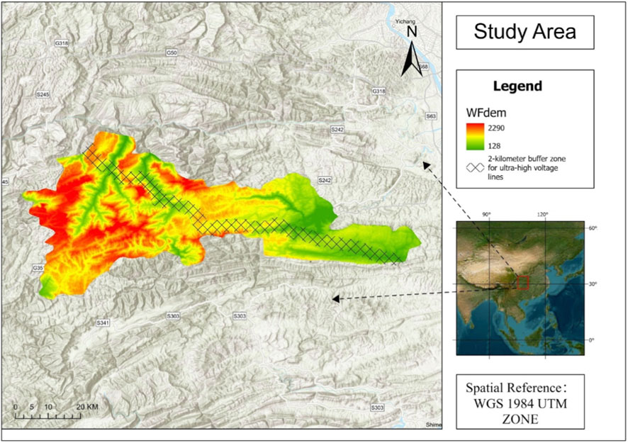
Figure 1. Overview map of the study area.
Geologically, Wufeng County lies within the tectonic belt of the middle and upper reaches of the Yangtze River, featuring complex geological structures. The area is prone to geological hazards such as mountain soil erosion, landslides, and rockfalls, with certain regions experiencing significant ground deformation risks. These characteristics make Wufeng County an ideal case study for monitoring ground deformation in UHV transmission corridors, particularly in mountainous and hilly areas where high-voltage power transmission lines are often installed.
Given the complexity of the terrain and the potential risks posed by geological hazards, the stability of transmission lines in this region is a critical concern. Therefore, monitoring ground deformation in Wufeng County is essential to ensure the safe operation of high-voltage transmission infrastructure and to mitigate the risks associated with potential geological disasters. This makes Wufeng County a representative site for studying the stability of UHV transmission corridors and their vulnerability to geohazards.
2.2 Data acquisition
The Sentinel-1A satellite is the first environmental monitoring satellite in the European Space Agency’s Copernicus program. It offers advantages such as high-frequency revisit, wide coverage, rich polarization and operational modes, as well as high reliability. In this study, a total of 24 Sentinel-1A satellite images from October 2023 to October 2024 were selected, covering the study area. The image data are in Level-1 SLC format, with an interferometric wide swath (W) imaging mode, VV polarization, an incident angle of 28.9°, and a spatial resolution of 5 m × 20 m (in azimuth and range directions) (in Table 1). Additionally, precise orbit data provided by the European Space Agency were used for orbit correction, and external reference DEM data from the 30-m resolution SRTM Digital Elevation Model (DEM) were used.
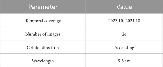
Table 1. Sentinel-1 dataset parameter information.
3 Methodology
DS-InSAR (Differential Synthetic Aperture Radar Interferometry) is a differential interferometric technique based on SAR imagery that uses image data from multiple time points to calculate surface deformation. The basic principle involves measuring the phase differences between images taken at different times to obtain deformation information. Specifically, for each pair of differential interferometric images, the phase difference can be expressed as:
In Equation 1, Where
First, using the registered single-look complex (SLC) image set, a baseline combination strategy of single-master image and multi-master image is employed for differential interferometric processing. This strategy effectively increases the time coverage of the interferograms and improves the monitoring accuracy, especially in landslide monitoring, a dynamic geological hazard. The extended time span is crucial for capturing deformation changes. Then, the differential interferogram is used to generate a single-look intensity image set to provide data support for subsequent target point extraction.
For target point extraction, the FaSHPS algorithm is used to select homogeneous point samples. The advantage of the FaSHPS algorithm lies in its ability to maintain a high level of point selection certainty in low-coherence areas, thus improving the quality of DS point selection. The algorithm’s settings require the number of homogeneous point samples to be greater than 20, with a posterior coherence greater than 0.3, ensuring that the extracted DS points are sufficiently reliable, providing accurate data support for subsequent deformation analysis. The FaSHPS algorithm enhances DS-InSAR’s ability to extract reliable distributed scatterers, which is particularly important in landslide monitoring applications where coherence varies significantly.
Subsequently, based on the differential interferometric set and the selected homogeneous point samples, the Phase Linking method is used for phase optimization. The Phase Linking method effectively reduces phase errors caused by terrain variations, atmospheric effects, and other factors, improving phase recovery accuracy. This optimization step further ensures the stability and consistency of the selected DS points in the time series analysis. Finally, the DS points are merged with the PS points to enhance monitoring accuracy. PS points typically exhibit higher scattering stability and can effectively complement the DS points, particularly in complex terrains and low-coherence areas. The fused data will be processed through 3D unwrapping to remove atmospheric effects, terrain residuals, and other factors influencing the phase, ultimately extracting time-series deformation information of the landslide area. This process effectively removes noise and errors, improving the precision and reliability of deformation monitoring.
Among these, the quality of the interferogram is a key factor influencing the deformation calculation results, making the selection of interferometric combinations a critical technical step in data processing. Currently, two main interferometric combination strategies exist: single-master image combination and small baseline combination. The core idea of the single-master image combination is to select one image from the multi-temporal SAR images as the common master image, with the other images serving as slave images. The basic idea of the small baseline combination is to set time baseline and spatial baseline thresholds, combining all images that meet both thresholds into pairs to form interferometric combinations, where each SAR image can serve as either the master or slave image. Lattice element modeling has also been employed to simulate cemented geomaterials under coupled loading conditions (Rizvi et al., 2020).
Among different interferometric techniques, PS-InSAR and SBAS-InSAR are suitable for areas with high coherence, while DS-InSAR is capable of obtaining more interferometric pairs in low-coherence regions. Marghany’s 4-D Quantized Holographic Interferometry Algorithm (Marghany, 2024) has further advanced this technology, particularly in solving the phase unwrapping problem in low-coherence areas. This algorithm introduces four-dimensional quantized phase recovery and quantum interference principles, significantly improving monitoring accuracy in complex terrain areas. Compared to traditional InSAR methods, Marghany’s algorithm can handle more complex terrain and low-coherence regions, greatly enhancing the reliability of deformation detection.
Since the observation targets in this study are landslides in the southwestern mountainous area, where the coherence of C-band SAR data is relatively poor compared to urban areas—especially in the summer when coherence is very low—the small baseline strategy is selected for this experiment. However, in phase optimization, a single-master image interferometric pair is included to assist in temporal phase optimization. When selecting the small baseline combination, the spatial baseline is controlled within 250 m, and the time baseline is controlled within 36 days. Figure 2 shows the interference connection diagram.

Figure 2. Interference connection diagram (a) Single master image connection diagram (b) Small baseline set connection diagram.
In addition, time-series phase optimization is one of the key cores in DS-InSAR, and its specific principles are as follows:
In Equation 2, where
4 Results
4.1 Extraction of backscatter point targets in low-coherence areas of complex mountainous regions
The hypothesis testing problem can be converted into a confidence interval estimation problem. Once the confidence interval is established, the similarity between all candidate points and reference points can be determined through simple logical operations, which significantly improves the speed of selecting distributed targets. Moreover, when the number of images is small, this algorithm exhibits better determinism in selecting homogeneous points compared to traditional non-parametric hypothesis testing methods. Particularly in the case of single-view data, where the pixel count of a single image is large, the FaSHPS algorithm can greatly improve computational efficiency while maintaining the quality of sample selection. SAR images are typically processed in single view to preserve the image’s detailed information as much as possible. For the small-area deformation extraction involved in this study, retaining the original resolution and capturing more deformation details are critical. Therefore, single-view processing becomes a necessary choice. The FaSHPS algorithm, based on this characteristic, can quickly and accurately extract distributed targets under complex data conditions. In this study, the FaSHPS algorithm was selected as the DS point extraction method, with a threshold set for homogeneous sample numbers greater than 20 to preliminarily filter candidate points, thereby efficiently identifying distributed target points. It is important to note that DS point extraction is not a one-time process and needs further optimization based on the phase consistency principle. The phase consistency principle can effectively help remove errors and inconsistent points, ensuring that the final extracted DS points accurately reflect deformation information.
Figure 3a shows the posterior coherence distribution map of the study area, where warm colors represent higher coherence and cool colors represent lower coherence. As shown in the figure, although most areas exhibit poor coherence, with the coherence coefficient of most points being below 0.3, the FaSHPS algorithm can still extract relatively reliable target points under low coherence conditions. Although the majority of the landslide body is non-man-made terrain and thus belongs to DS points, there are also some permanent scatterers in the region, such as houses, towers, and large rocks. These points, which have high backscatter stability, can be used as PS points in calculations to help improve the overall data quality. The selection of PS points can be based on the spectral characteristics of single SLC images and the amplitude deviation of multi-scene SLC images. By combining these two methods, the selection of PS points can be further optimized. In Figure 3b, we selected 6,580 PS points using both spectral characteristics and amplitude deviation methods, which are shown in red in the figure. However, although a large number of PS points were selected through these methods, the areas with low coherence still influenced the selection results, leading to some limitations in the quality of the selected points.
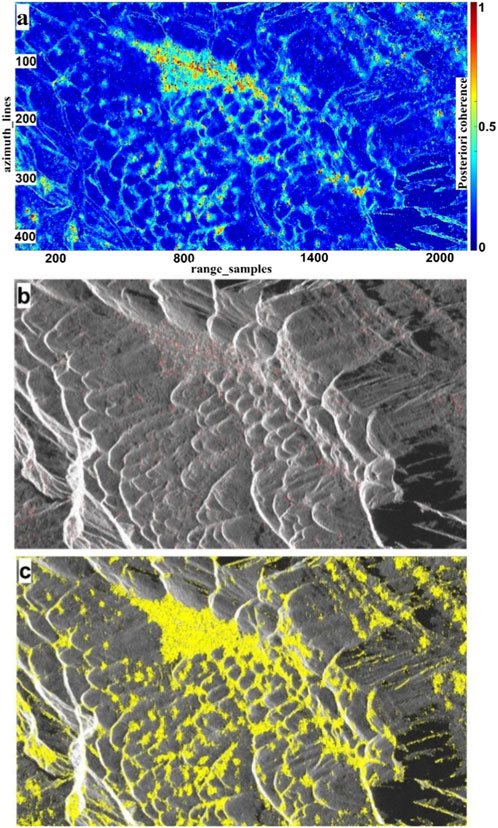
Figure 3. Point selection results: (a) Posteriori coherence; (b) Point selection results based on spectral characteristics and backscatter coefficient; (c) Point selection results based on homogeneous samples.
Although most of the landslide body consists of non-man-made surfaces and belongs to DS points, there are still permanent scatterer targets such as houses, towers, and large rocks. These PS points, though few, have high backscatter stability and can assist in calculations to improve the overall data quality. PS points can be selected based on the spectral characteristics of single SLC images and the amplitude deviation of multi-scene SLC images, and the final selection of PS points is a fusion of these two methods. As shown in Figure 3b, by using both spectral characteristics and amplitude deviation for point selection, 6,580 points were extracted, shown in red in the figure. Clearly, low coherence severely affected the selection results. However, by selecting points based on homogeneous samples, the number of selected points was significantly increased, greatly improving the quality for subsequent point-time series analysis.
4.2 Time-series phase recovery
Phase Linking is used for phase optimization, which significantly improves phase results compared to the original phase, especially in areas with low coherence, where a certain degree of phase information can still be recovered. This effectively increases the number of available observation points. By using the phase linking method, this technology overcomes the limitations of traditional InSAR technology in regions with poor coherence, significantly enhancing the accuracy and stability of deformation monitoring. In large-scale deformation areas, many observation points are not selected using traditional methods due to the effects of spatiotemporal decorrelation. However, after phase linking optimization, these observation points can potentially be restored, greatly increasing the number of available observation points and improving the reliability of deformation data. The application of this optimization technology in deformation monitoring, especially in complex terrains or extreme environments, is of great significance.
Figures 4a,b show the comparison before and after optimization for the 20231019_20231031 interferogram, where the XY axes represent pixel distance. The interferogram before optimization exhibits significant noise, particularly at the boundaries of high-coherence regions, where the image details are blurry, affecting the accuracy of deformation analysis. After applying the Phase Linking technology, the optimized interferogram can more stably and reliably extract phase information, with significantly improved boundary clarity and overall phase recovery. Compared to traditional spatial filtering methods, Phase Linking filters in the time domain, which more effectively captures the spatiotemporal characteristics in the observational data, thus optimizing the phase recovery.
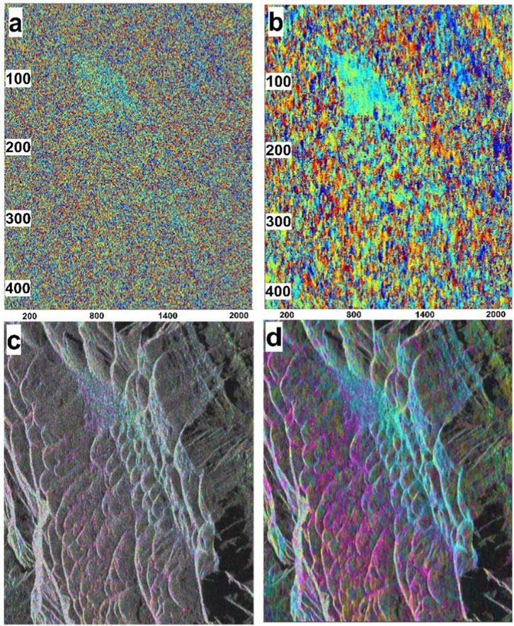
Figure 4. Time-series phase optimization results: (a) and (c) are before optimization; (b) and (d) are after optimization.
Figures 4c,d show the comparison before and after optimization for the 20231019_20231206 interferogram. The significant improvement in phase recovery after optimization further verifies the universality and reliability of Phase Linking across different interferograms. In this interferogram, the optimized phase map shows clearer details and significantly reduced noise, indicating that Phase Linking technology not only meets the optimization needs of a single interferogram but also has strong versatility, making it widely applicable to deformation monitoring in different time spans and geographic environments.
4.3 Time-series deformation extraction and analysis
Figure 5 shows the line-of-sight (LOS) deformation rate of the study area obtained using different methods. The study area primarily consists of mountainous terrain with dense vegetation cover, lacking typical strong scatterer targets such as buildings and bare rock. This makes it difficult for the traditional SBAS-InSAR method to obtain effective point target information, resulting in a sparse distribution of point targets in the analysis (Figure 5a). This limitation restricts the application of SBAS-InSAR in complex terrain and vegetation-covered areas, particularly in low-coherence regions, where traditional methods fail to provide enough valid information, making accurate deformation monitoring challenging. In contrast, the DS-InSAR method significantly improves the spatial density of point targets by optimizing the data processing workflow and enhancing the coherence of the interferogram. This is particularly effective in low-coherence areas (Figure 5b). This method effectively overcomes the limitations of traditional SBAS-InSAR, and even in complex terrain environments such as high mountains and dense forests, it can stably extract more point targets and perform precise deformation monitoring. This makes DS-InSAR the preferred method for application in adverse environments.
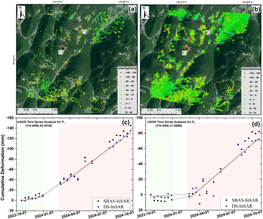
Figure 5. Deformation extraction results: (a) SBAS-InSAR extraction results; (b) DS-InSAR extraction results; (c) Time series of point P1; (d) Time series of point P2.
Figures 5c,d show that although there are slight differences in the deformation results between the two methods in terms of time series, the overall trends are consistent. At feature point P1, the maximum cumulative deformation using the SBAS-InSAR method is −140 mm, while the DS-InSAR method gives a maximum cumulative deformation of −130 mm. At feature point P2, the maximum cumulative deformation for the SBAS-InSAR method is −80 mm, and for DS-InSAR it is −70 mm. Although these differences are relatively small, they still indicate a significant bias in deformation estimation using the SBAS-InSAR method. This bias may be due to the insufficient processing ability of the method in low-coherence areas, leading to an overestimation of deformation values.
Further comparison of the time series reveals a clear phase change in the deformation behavior of the study area. At feature points P1 and P2, a sudden change in deformation trend is observed around April 2024, characterized by a significant acceleration in the deformation rate. This change may be related to geological activity, climate change, or human engineering activities in the region.
5 Discussion and conclusion
The construction of ultra-high voltage transmission corridors typically requires traversing complex geological environments such as mountains, hills, and rivers. These areas are often prone to geological disasters. On the other hand, the detectability in vegetation-covered, low-coherence regions is significantly reduced. These regions, often regarded as monitoring blind spots, warrant further attention.
The study area selected in this paper lies within an ultra-high voltage transmission corridor. This region exhibits significant topographical changes, with continuous elevation variations and terrain features. Additionally, the dense vegetation cover makes it an ideal area for algorithm validation. The Phase Linking phase optimization technology has significant advantages in handling complex environments, improving deformation monitoring accuracy, increasing the number of observation points, and enhancing monitoring stability. By using the phase linking method, this technology overcomes the limitations of traditional InSAR technology in regions with poor coherence, significantly enhancing the accuracy and stability of deformation monitoring. In large-scale deformation areas, many observation points are not selected using traditional methods due to the effects of spatiotemporal decorrelation. However, after phase linking optimization, these observation points can potentially be restored, greatly increasing the number of available observation points and improving the reliability of deformation data. The application of this optimization technology in deformation monitoring, especially in complex terrains or extreme environments, is of great significance.
Furthermore, the time series analysis results from two InSAR methods offer valuable insights. Although DS-InSAR tends to be more conservative in deformation estimation, it provides a more stable and reliable deformation trend, especially in low-coherence regions. However, the SBAS-InSAR method, while limited in data processing and result estimation, can still be effectively applied in areas with strong scatterer targets. DS-InSAR, by optimizing data processing algorithms, enhances monitoring capabilities in low-coherence regions, making it particularly suitable for deformation monitoring in complex terrains and vegetation-covered areas. It shows stronger applicability and accuracy compared to traditional methods.
This study addresses some key technical issues in deformation extraction in low-coherence areas within ultra-high voltage transmission corridors. The results show that DS-InSAR can effectively tackle the deformation errors caused by sparse InSAR monitoring points in low-coherence regions. After optimization with the Phase Linking method, the phase results are significantly improved, with clearer boundaries of deformation regions and a significant reduction in noise. Additionally, the number of valid monitoring points increased from 1481 to 7698, leading to the extraction of reliable deformation results. The annual average deformation rate extracted using SBAS-InSAR is −146 to −49 mm/year, while the annual average deformation rate extracted using DS-InSAR is −144 to −74 mm/year. The overall deformation trends are similar, but the SBAS-InSAR technology slightly overestimates the magnitude of deformation. The successful application of this method provides a feasible approach for deformation extraction in low-coherence regions and offers theoretical support for addressing geological disaster-related issues in the construction of ultra-high voltage transmission corridors.
Data availability statement
The original contributions presented in the study are included in the article/supplementary material, further inquiries can be directed to the corresponding author.
Author contributions
YL: Writing – review and editing, Writing – original draft. SW: Writing – original draft, Writing – review and editing. BL: Writing – review and editing, Writing – original draft. BZ: Validation, Writing – review and editing. HH: Writing – original draft, Writing – review and editing. XK: Supervision, Writing – original draft. YD: Writing – original draft, Writing – review and editing.
Funding
The author(s) declare that financial support was received for the research and/or publication of this article. This work was supported by the Science and technology project of State Grid “Research and Engineering Application of Key Technologies for Digitized Monitoring of High Slope Hazards on Power Transmission Line Towers” under Grant No. 5200-202322139A-1-1-ZN.
Conflict of interest
Authors LY, LB, ZB, and XK were employed by State Grid Electric Power Engineering Research Institute Co., Ltd. Authors WS, HH, and DY were employed by State Grid Hubei Electric Power Co., Ltd. Extra High Voltage Company.
Generative AI statement
The author(s) declare that no Generative AI was used in the creation of this manuscript.
Any alternative text (alt text) provided alongside figures in this article has been generated by Frontiers with the support of artificial intelligence and reasonable efforts have been made to ensure accuracy, including review by the authors wherever possible. If you identify any issues, please contact us.
Publisher’s note
All claims expressed in this article are solely those of the authors and do not necessarily represent those of their affiliated organizations, or those of the publisher, the editors and the reviewers. Any product that may be evaluated in this article, or claim that may be made by its manufacturer, is not guaranteed or endorsed by the publisher.
References
Ahmad, S., Rizvi, Z. H., Arp, J. C. C., Wuttke, F., Tirth, V., and Islam, S. (2021). Evolution of temperature field around underground power cable for static and cyclic heating. Energies 14, 8191. doi:10.3390/en14238191
Ahmad, S., Ahmad, S., Akhtar, S., Ahmad, F., and Ansari, M. A. (2025). Data-driven assessment of corrosion in reinforced concrete structures embedded in clay dominated soils. Sci. Rep. 15, 22744. doi:10.1038/s41598-025-08526-w
Bao, J., Luo, X., Liu, G., Chang, L., Wang, X., Shi, Y., et al. (2021). An improved distributed scatterers extraction algorithm for monitoring tattered ground surface subsidence with DSInSAR: a case study of loess landform in tongren county. Int. J. Appl. Earth Obs. Geoinformation 99, 102322. doi:10.1016/j.jag.2021.102322
Ferretti, A., Colombo, D., Fumagalli, A., Novali, F., and Rucci, A. (2011). “InSAR data for monitoring land subsidence: time to think big,” in Proceedings of the International Association of Hydrological Sciences, 331–372.
Greif, V., and Vlcko, J. (2012). Monitoring of post-failure landslide deformation by the PS-InSAR technique at Lubietova in Central Slovakia. Environ. Earth Sci. 66, 1585–1595. doi:10.1007/s12665-011-0951-x
Kang, Y., Zhao, C., Zhang, Q., Lu, Z., and Li, B. (2017). Application of InSAR techniques to an analysis of the Guanling landslide. Remote Sens. 9, 1046. doi:10.3390/rs9101046
Kiseleva, Е., Mikhailov, V., Smolyaninova, E., Dmitriev, P., Golubev, V., Timoshkina, E., et al. (2014). PS-InSAR monitoring of landslide activity in the Black Sea coast of the caucasus. Procedia Technol. 16, 404–413. doi:10.1016/j.protcy.2014.10.106
Lei, L., Zhou, Y. Q., Li, J. W., and Burgmann, R. (2012). Application of PS-InSAR technology in Berkeley Hills landslide monitoring. J. Beijing Univ. Aeronautics Astronautics 38, 1224–1226. doi:10.13700/j.bh.1001-5965.2012.09.005
Li, Z., Dai, K., Deng, J., Liu, C., Shi, X., Tang, G., et al. (2023). Identifying potential landslides in steep mountainous areas based on improved seasonal interferometry Stacking-InSAR. Remote Sens. 15, 3278. doi:10.3390/rs15133278
Marghany, M. (2021). Advanced algorithms for mineral and hydrocarbon exploration using synthetic aperture radar. Elsevier.
Marghany, M. (2024). “Four-dimensional radar hologram interferometry for monitoring oil and gas exploration near kharg island,” in Oceanographic and marine environmental studies around the arabian peninsula (Boca Raton, FL, United States: CRC Press), 173–182.
Moretto, S., Bozzano, F., and Mazzanti, P. (2021). The role of satellite InSAR for landslide forecasting: limitations and openings. Remote Sens. 13, 3735. doi:10.3390/rs13183735
Novellino, A., Cesarano, M., Cappelletti, P., Di Martire, D., Di Napoli, M., Ramondini, M., et al. (2021). Slow-moving landslide risk assessment combining machine learning and InSAR techniques. Catena 203, 105317. doi:10.1016/j.catena.2021.105317
Rizvi, Z. H., Mustafa, S. H., Sattari, A. S., Ahmad, S., Furtner, P., and Wuttke, F. (2020). “Dynamic Lattice Element Modelling of Cemented Geomaterials,” in Advances in Computer Methods and Geomechanics. Lecture Notesin Civil Engineering, Editor A. Prashant, A. Sachan, and C. Desai (Singapore: Springer), Vol. 55.
Rosi, A., Tofani, V., Tanteri, L., Tacconi Stefanelli, C., Agostini, A., Catani, F., et al. (2018). The new landslide inventory of tuscany (italy) updated with PS-InSAR: geomorphological features and landslide distribution. Landslides 15, 5–19. doi:10.1007/s10346-017-0861-4
Schlögel, R., Doubre, C., Malet, J.-P., and Masson, F. (2015). Landslide deformation monitoring with ALOS/PALSAR imagery: a D-InSAR geomorphological interpretation method. Geomorphology 231, 314–330. doi:10.1016/j.geomorph.2014.11.031
Sun, Q., Zhang, L., Ding, X. L., Hu, J., Li, Z. W., and Zhu, J. J. (2015). Slope deformation prior to zhouqu, China landslide from InSAR time series analysis. Remote Sens. Environ. 156, 45–57. doi:10.1016/j.rse.2014.09.029
Yao, J., Yao, X., and Liu, X. (2022). Landslide detection and mapping based on SBAS-InSAR and PS-InSAR: a case study in gongjue county, Tibet, China. Remote Sens. 14, 4728. doi:10.3390/rs14194728
Yin, Y., Zheng, W., Liu, Y., Zhang, J., and Li, X. (2010). Integration of GPS with InSAR to monitoring of the jiaju landslide in sichuan, China. Landslides 7, 359–365. doi:10.1007/s10346-010-0225-9
Keywords: DS-InSAR, phase linking, homogeneous sample selection, ultra-high voltage (UHV) transmission, geological disasters
Citation: Liu Y, Wang S, Liu B, Zhao B, Han H, Kong X and Do Y (2025) Interferometry phase recovery and deformation extraction in low-coherence UHV transmission corridors of complex mountainous regions. Front. Earth Sci. 13:1682093. doi: 10.3389/feart.2025.1682093
Received: 08 August 2025; Accepted: 23 October 2025;
Published: 18 December 2025.
Edited by:
Manoj Khandelwal, Federation University Australia, AustraliaReviewed by:
Zarghaam Rizvi, Geo Analysis Engineering GmbH, GermanyMaged Marghany, Universitas Malikussaleh, Indonesia
Copyright © 2025 Liu, Wang, Liu, Zhao, Han, Kong and Do. This is an open-access article distributed under the terms of the Creative Commons Attribution License (CC BY). The use, distribution or reproduction in other forums is permitted, provided the original author(s) and the copyright owner(s) are credited and that the original publication in this journal is cited, in accordance with accepted academic practice. No use, distribution or reproduction is permitted which does not comply with these terms.
*Correspondence: Yi Liu, bGl1X3lpXzM2OUAxNjMuY29t
†ORCID: Yi Liu, orcid.org/0000-0002-0234-3504