 Siyang Li
 Yanbo Cao
 Xin Huang
 Yufan Xu
 Sheng Li
- Yunnan Earthquake Agency, Kunming, China
Honghe Prefecture in Yunnan Province is rich in mineral resources, with a large number of tailings ponds distributed extensively. Located in the southern segment of the Xiaojiang fault zone, it has complex geological structures and frequent seismic activities, making it one of the high seismic risk areas in China. Under seismic action, tailings ponds may trigger secondary disasters such as dam failure and tailings leakage, posing severe threats to the environment and socio-economy. This study identifies the spatial distribution characteristics and disaster-causing mechanisms of tailings ponds by analyzing seismic hazard factors, and constructs a hazard assessment model using GIS spatial analysis, information quantity model, and analytic hierarchy process (AHP) to generate a seismic hazard zoning map of tailings ponds. Twelve evaluation indicators for seismic geological hazards and eight factors for tailings pond seismic hazards are selected. By integrating multi-source data, quantifying the correlation between each indicator and disasters, and determining factor weights, a comprehensive evaluation model is formed. Based on the results, prevention and control strategies such as dam reinforcement and monitoring early warning are proposed. The results show that tailings ponds with low hazard are mostly distributed in geologically stable areas, while those with medium to high hazard are concentrated in eastern Gejiu City, southern Jianshui County, and southern Mile City, significantly affected by factors such as fault zone activities. The research results not only provide a scientific basis for the safety management of tailings ponds but also offer technical support for seismic resistance management and disaster prevention in other earthquake-prone areas.
1 Introduction
Honghe Prefecture in Yunnan Province is rich in mineral resources. Mining development provides important material and energy support for economic growth, while mineral processing generates a large amount of solid waste, namely, tailings (Owen et al., 2020). Except for a small portion utilized comprehensively, most tailings are stored in tailings ponds for environmental protection or potential future use (Chen and Ma, 2022). To maximize storage capacity, most mountainous tailings ponds are constructed by blocking valley mouths. Due to the large amount of tailings and water stored in the ponds, tailings ponds become potential hazard sources with high potential energy and high destructive power (Cheng et al., 2021), and their safety is directly related to the sustainable development of mining areas and the stability of the surrounding environment (Wu et al., 2023). However, under seismic action, tailings ponds may cause dam deformation and slope instability, triggering a series of disasters (Villavicencio et al., 2014), including secondary disasters such as dam landslides, liquefaction failure, dam rupture, and tailings leakage (Verdugo et al., 2012), which can result in losses of lives and properties as well as ecological environment damage in severe cases (Ren et al., 2018; Chen et al., 2023). Although some studies at home and abroad have focused on the stability and seismic design of tailings ponds, systematic research on hazard assessment combining historical earthquakes and seismic geological disasters remains insufficient (Aswathi and Jakka, 2024). This study comprehensively evaluates the seismic geological hazard of tailings ponds in Honghe Prefecture, Yunnan Province, by integrating multi-source data, using GIS spatial analysis, and combining information quantity model and AHP to construct a modern hazard evaluation model. The results not only provide a scientific basis for tailings pond safety management but also offer technical support for seismic resistance management and disaster prevention in Yunnan and other earthquake-prone regions.
Seismic geological hazard analysis, as a key field of environmental safety and disaster prevention, has attracted extensive attention from scholars worldwide in recent years. For example, Chen et al. (2025) evaluated landslide susceptibility in the high-intensity area of the Luding earthquake using game theory-based combination weighting and information quantity model, and mapped the landslide susceptibility zoning. Chen et al. (2014) considered 10 potential factors in Chencang District, Baoji City, used the information value model to produce a geological hazard susceptibility map, and divided susceptibility zones and prevention zones. Du et al. (2017) proposed an integrated model combining information quantity method and logistic regression for geological hazard susceptibility assessment in the Bailongjiang River basin, Gansu Province. Malakar et al. (2022) assessed seismic risk in the Himalayan tectonic region, generated hazard maps, and provided references for seismic disaster mitigation and strategy formulation. Mavroulis et al. (2022) studied earthquake-triggered landslide susceptibility using multiple landslide-causing factors on Cephalonia Island, found high correlations between multiple factors and landslide locations, and evaluated regional seismic hazard. With the rise of GIS technology, international studies have combined spatial analysis with regional disaster assessment (Kavzoglu et al., 2013; Bopche et al., 2022). Shadmaan and Popy (2023) used AHP to assess seismic vulnerability in Sylhet, Bangladesh, revealing geological hazard areas in different aspects of the region. Ahmad et al. (2022) conducted geological hazard risk assessment in Pakistan based on remote sensing and GIS data models. Yu et al. (2020) used 3D numerical simulation and GIS to reveal the impact of earthquake-triggered tailings pond disasters on complex terrain areas. Jena et al. (2020) proposed that GIS can be integrated with traditional models to assess potential seismic risks of tailings ponds. In addition, with the expansion of resource development, seismic hazard issues have become prominent, and remote sensing, machine learning, and big data technologies have been introduced into hazard risk assessment (Sahar et al., 2010; Theilen-Willige et al., 2016). For example, Yang et al. (2023) used the weight-of-evidence method to assess earthquake-induced landslide risks. Devara et al. (2021) combined AHP with MT-InSAR technology for geological hazard susceptibility mapping, demonstrating its potential in generating and updating near-real-time susceptibility maps. Fentahun et al. (2021) integrated AHP and Differential Interferometric Synthetic Aperture Radar (DInSAR) to assess seismic hazard susceptibility in the Ethiopian Rift and produced susceptibility maps. Li et al. (2024) introduced a random forest-weighted information quantity method to address the limitations of traditional information quantity models in geological hazard susceptibility evaluation. Zou et al. (2023) analyzed the pollution diffusion hazards of tailings ponds after earthquakes using GIS and data simulation. These studies provide rich theoretical and practical experiences for seismic geological hazard analysis and prevention.
However, existing studies still have limitations: insufficient accuracy in seismic hazard assessment, the need to improve models simulating the interaction between earthquakes and tailings ponds, weak data sharing mechanisms affecting emergency response speed, inadequate regional hazard assessment research, and unclear understanding of disaster distribution patterns in tailings ponds in complex geological areas. Given the uncertainty of earthquake-induced geological hazards, GIS-based, statistically driven spatial analysis methods for regional seismic geological hazards (Li et al., 2021; Qazi et al., 2023), which determine evaluation indicator weights based on historical data and hazard-forming environment factors (Nyimbili et al., 2018), are becoming a research hotspot, making regional geological hazard evaluation more scientific and reliable.
This study focuses on tailings ponds in Honghe Prefecture, Yunnan Province, targeting seismic geological hazards. Combining geological survey data, and using GIS, GEE platforms (Google Earth Engine), and SPSS statistical software, it explores the spatial distribution of seismic disasters and impact factors of tailings pond seismic disasters through GIS spatial analysis, information quantity model, and AHP, and evaluates seismic geological hazards under moderate conditions. The results can enrich theoretical research on seismic disasters and provide long-term scientific and technical support for tailings pond seismic risk planning, prevention engineering layout, and disaster reduction, with significant scientific and applied value.
1.1 Study area overview
As shown in the Figure 1, Honghe Prefecture is located in southern Yunnan, covering an area of approximately 32,174 km2. It lies in the transition zone between the southern margin of the Yunnan-Guizhou Plateau and the northern end of the Hengduan Mountains, with rugged terrain where mountainous areas account for 88.5%. The terrain is high in the northwest and low in the southeast, with an elevation difference exceeding 3,000 m. Geologically, it is controlled by the Ailao Mountain-Honghe fault zone, a boundary between the Indochina Block and the South China Block with frequent activities, making it an earthquake-prone area. Since 886 AD, there have been 19 earthquakes with Ms ≥ 5.0 in the region, and high-intensity areas are concentrated along both sides of the Ailao Mountain-Honghe fault zone. Honghe Prefecture has complex topographic and geological conditions, frequent earthquakes, and severe geological hazard risks, posing a serious threat to the safety of facilities such as tailings ponds.
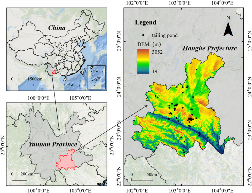
Figure 1. Location of the study area.
To date, 1,806 geological hazard points have been identified in the prefecture, with 1,262 points (69.88% of the total) in 6 southern counties, threatening 115,000 people. Tailings ponds in Honghe Prefecture are mostly distributed in mineral-rich areas, with small-scale ponds accounting for over 70%. Once the dam is unstable, it will severely affect downstream ecology and residents’ safety. Despite local investment in special funds for geological hazard prevention, including hazard investigation and monitoring early warning, traditional assessment methods rely on subjective surveys, lack probabilistic model support, and struggle to quantify risks accurately, highlighting the need for more scientific assessment methods to improve disaster prevention capabilities.
2 Data and methods
2.1 Data sources
This study collected extensive data, including geological structure, topographic and geomorphic data, Digital Elevation Model (DEM) data, and geological survey results from the Ministry of Natural Resources of China, ensuring the accuracy of basic geological information. Seismic activity data were obtained from the earthquake monitoring network of Yunnan Earthquake Agency, covering key parameters such as historical earthquake magnitude, epicenter location, and occurrence time, providing a reliable basis for seismic hazard analysis. Tailings pond data were collected through field surveys, enterprise reports, and archives from emergency management departments, including location, scale, type, and dam structure. Auxiliary data such as hydrometeorological data were sourced from local meteorological monitoring records. Seismic geological hazard point data were obtained from the data platform of the Ministry of Natural Resources of China, GEE platform, and global disaster data platforms. Multi-source data complement each other to ensure comprehensiveness, accuracy, and reliability.
When integrating multi-source datasets, aiming at the spatial uncertainty of various types of data under the GIS framework, this study implements control from three stages. Firstly, hierarchical control of data sources is conducted, with high-reliability data prioritized, such as 30 m × 30 m DEM, 1:50,000 geological maps, fault zone data and seismic data integrated in the database of Yunnan Earthquake Agency. For tailings pond data, enterprise-reported data combined with statistical data from Yunnan Earthquake Agency is adopted. Secondly, preprocessing correction is carried out: basic geological data undergoes unified data cleaning, ArcGIS topological inspection is used to eliminate tailings pond boundary errors, and Kriging interpolation is applied to data-missing areas with error ranges marked (Salari, 2025). Thirdly, result verification is performed: by adjusting the spatial thresholds of key parameters (e.g., changing the fault distance classification from 0-1,000 m to 0–1,500 m), the change rate of hazard zoning is analyzed, and the stability of results against spatial parameter fluctuations is verified to ensure that the impact of uncertainty is minimal.
This study uses 76 tailings ponds in Honghe Prefecture. Sample data of tailings ponds are shown in Table 1.
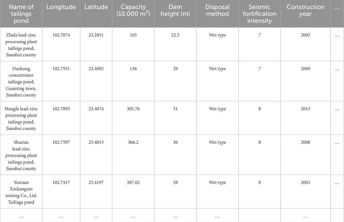
Table 1. Some sample data of tailings ponds.
2.2 Research methods
This study uses GIS spatial analysis, information quantity model, and AHP to analyze the seismic geological hazard of tailings ponds, study the relationship between tailings ponds and distance from epicenters and earthquake-prone areas, construct a tailings pond seismic hazard evaluation model, and conduct a comprehensive zoning evaluation of seismic geological hazards of tailings ponds in Honghe Prefecture.
First, GIS spatial analysis is used to extract data on hazard factors such as basic geological information, seismic activity, and geological hazards. The information quantity model calculates the information value of each hazard factor, and superimposing these values identifies the seismic geological hazard level of the area where tailings ponds are located. Then, AHP analyzes the weight of each hazard factor for tailings ponds, constructs a hazard evaluation model based on factor weights, and finally conducts a comprehensive zoning evaluation of tailings pond seismic hazards.
In this study, 12 seismic geological hazard assessment indicators and 8 tailings pond seismic hazard assessment factors were selected for analysis, and these indicators and factors can reflect the impacts of seismic geological hazards and human factors on tailings ponds from multiple aspects. The selection of the 12 seismic geological hazard indicators and 8 tailings pond seismic hazard assessment factors followed three procedures: literature review, statistical optimization, and expert verification, so as to ensure the independence and relevance of the indicators. Firstly, through a systematic review of research by various scholars and combining with the on-site regional characteristics of Honghe Prefecture (where mountainous areas account for 88.5% and small-scale wet tailings ponds account for over 70%), 18 candidate indicators and factors were initially identified. Secondly, SPSS was used to conduct Pearson correlation analysis and Variance Inflation Factor test on the data of 76 tailings ponds, 6 indicators with low correlation were eliminated, and finally 12 seismic geological indicators were retained. Finally, 10 experts in the field, covering geological engineering, seismology, tailings pond management and other fields, were invited to score the necessity of the 8 tailings-specific factors using the Delphi method, with a consistency rate of 92%. Additionally, 10 typical tailings ponds were selected for on-site verification to confirm the rationality of the indicators and factors.
In this study, 12 seismic geological hazard assessment indicators and 8 tailings pond seismic hazard assessment factors were selected for analysis. These indicators and factors can reflect the impacts of seismic geological hazards and human factors on tailings ponds from various aspects. Among the 12 seismic geological hazard assessment indicators, topographic and geomorphic indicators, such as elevation, slope, and aspect, are closely related to the occurrence of seismic hazards. In areas with large elevation differences, steep slopes, and obvious mountain aspects, tailings ponds are more prone to instability phenomena such as dam failure during earthquakes. Regarding geological lithology indicators, hard rocks can provide stable support for tailings pond dams (Ahmad et al., 2025a), while soft rocks are prone to deformation and damage under seismic action (Ahmad et al., 2025b), increasing the risk of tailings pond dam failure. The distribution of fault zones determines the frequency and intensity of earthquakes, thereby affecting the safety of tailings ponds (Akbarzadeh et al., 2024; Dehghananari, 2025). For water system indicators, the erosion of water bodies will reduce the resistance of slopes (Ahmad et al., 2019), making landslides more likely to occur near tailings ponds during earthquakes. As for road indicators, road construction will damage and affect the rock slopes and vegetation near tailings ponds, leading to greater vulnerability to damage during earthquakes. Concerning seismic activity indicators, the closer to the epicenter, the higher the probability and degree of damage to tailings ponds. The greater the peak ground acceleration, the larger the inertial force on tailings ponds, making them more prone to damage. In terms of land use type, areas with frequent human activities cause significant disturbance to the ground surface, which easily leads to geological hazards and subsequent damage to tailings ponds (Nikvand and Bonab, 2024). For vegetation coverage, good vegetation coverage can enhance soil stability and prevent the occurrence of geological hazards near tailings ponds. Regarding rainfall factors, heavy rainfall tends to loosen the surface soil, making tailings ponds more vulnerable to impact when earthquakes occur. By synthesizing the above 12 seismic geological hazard assessment indicators, information on the hazard level of the location where the tailings pond is situated can be obtained. The more unstable the geological conditions of the location, the more likely the tailings pond is to be damaged by geological hazards when an earthquake occurs. The 8 tailings pond seismic hazard assessment factors enable a comprehensive evaluation of the hazard level of tailings ponds. The seismic geological hazard level zone factor intuitively demonstrates the potential impact degree of tailings ponds under different geological conditions through the division of hazard levels based on the geological conditions where the tailings ponds are located. For the seismic fortification level factor, a higher fortification level results in a more stable tailings pond dam. Factors such as the presence of residential areas, important facilities, rivers, important road facilities, and farmland downstream of the tailings pond indicate the scope and degree of harm that would be caused in the event of a tailings pond dam failure. For the seismic intensity factor, a higher intensity leads to greater gravitational and inertial forces acting on the tailings pond under seismic action, making it more likely to affect the stability of the tailings pond. Historical earthquake disaster events can reflect whether the tailings pond has suffered partial damage under seismic action. By synthesizing the above factors, a clear understanding of the seismic geological hazard risk of tailings ponds can be obtained.
2.2.1 GIS spatial analysis
GIS spatial analysis is a spatial data analysis technology based on the location and form of geographic objects (Shu et al., 2024). Using GIS’s powerful spatial analysis and data processing functions (Wu et al., 2019), spatial data such as the geographical location, topography, geological structure, and geological hazards of tailings ponds can be quickly obtained. Hazard evaluation results are visually displayed in maps (Zhai et al., 2019), facilitating intuitive understanding of the spatial distribution characteristics of tailings pond seismic hazards. The application of GIS technology improves research efficiency and visualization (Mahmoody Vanolya and Jelokhani-Niaraki, 2019; Kang et al., 2024), providing more intuitive support for decision-making.
2.2.2 Information quantity model
The information quantity model is a statistical prediction method that calculates the information value of each evaluation factor in an evaluation unit based on the number of seismic geological hazards in each influencing factor (Zhang et al., 2023; Qiao et al., 2025), The total information value of geological hazards in each unit is obtained by superimposing the information values of all evaluation factors (Ding et al., 2025). A higher information value indicates a higher probability of geological hazards in the region. The calculation formula is shown in Equation 1:
where: xi represents the evaluation factor of the evaluation unit, Ii is the sum of information values of each evaluation factor in the unit, n is the total number of evaluation factors, Ni is the number of geological hazard points in a certain factor classification, N is the total number of geological hazard points in the study area, Si is the area of the corresponding factor classification in the study area, S is the total area of the study area.
2.2.3 Analytic hierarchy process (AHP)
AHP is a decision-making evaluation method combining multi-objective, qualitative and quantitative analysis, and integrating weights of different information (Lai et al., 2019; Panchal and Shrivastava, 2022). It has obvious advantages in handling complex systems that are difficult to solve entirely with quantitative methods, as well as multi-factor, multi-level, and multi-objective complex systems (Lyu et al., 2018; Noorollahi, 2018).
The main steps of AHP in this paper are as follows: Take the comprehensive evaluation of seismic geological hazard as the target layer, decompose it into the criterion layer and factor layer, determine the importance of each factor relative to the target layer using a 9-point scale, and construct a judgment matrix, Calculate the maximum eigenvalue and corresponding normalized eigenvector of the matrix to determine the weight of each factor, And calculate the consistency test of the results. If the consistency ratio CR < 0.1, the constructed judgment matrix is considered reasonable, otherwise, the judgment matrix needs to be adjusted until CR < 0.1.
The maximum eigenvalue of the judgment matrix is calculated using Equation 2:
where: λmax is the maximum eigenvalue of the judgment matrix, A is the judgment matrix, W is the weight matrix, n is the order of the judgment matrix, (AW)i is the ith element of AW, Wi is the corresponding element of the normalized W.
The consistency test index of the judgment matrix is calculated using Equation 3:
where: CI is the consistency index of the judgment matrix.
Considering that consistency deviation may be caused by random factors, when testing whether the judgment matrix has satisfactory consistency, CI should be compared with the random consistency index RI to obtain the test coefficient CR. The calculation formula is shown in Equation 4:
where: CR is the random consistency ratio, RI is the random consistency index.
3 Analysis
3.1 Classification of seismic geological hazard evaluation indicators
Based on the analysis of seismic geological hazards and hazard-forming environmental factors in the study area, 12 factors were selected for geological hazard assessment, including elevation, slope, Slope direction, geological lithology, distance from faults, distance from rivers, distance from main roads, distance from historical earthquake epicenters, peak ground acceleration, land use type, NDVI, and rainfall. The value of a single evaluation index has a certain range, and its different states will affect the evaluation results (Chawla et al., 2019). The classification of evaluation indices is to find a reasonable division of the state space for each evaluation index (Tan et al., 2020).
Topographic factors such as elevation, slope, and aspect can change the propagation characteristics of seismic waves and affect the stress state of dams. In steep slope areas, dams are more prone to instability such as landslides during earthquakes (Ding et al., 2025). Different geological lithologies have significant differences in physical and mechanical properties, directly affecting the stability of tailings pond dams. Hard rocks such as granite have high shear strength and can provide stable support for dams; while soft rocks such as shale and mudstone have low shear strength (Ahmad et al., 2021), easily deforming and failing under seismic action, increasing the risk of dam instability (Lai et al., 2020). Fault distribution in geological structures determines the frequency and intensity of earthquakes, as well as the propagation path and energy distribution of seismic waves, thereby affecting the safety of tailings ponds (Chang et al., 2022). Water systems such as rivers and lakes erode and damage rock and soil masses, reducing slope resistance and increasing imbalance, thus significantly influencing the formation of seismic disasters (Psomiadis et al., 2020). Road construction can damage nearby rock slopes and vegetation, increasing the possibility of geological hazards (Wang et al., 2019). For seismic activity factors, epicentral distance determines the intensity of seismic impact on tailings ponds: the closer to the epicenter, the stronger the ground motion, and the higher the probability and degree of damage to tailings ponds. Peak ground acceleration is a key parameter measuring ground motion intensity, directly acting on tailings pond dams; higher acceleration leads to greater inertial force on dams, increasing the risk of structural damage (Yousuf et al., 2020). Land use type: Areas with frequent human activities severely disturb the surface, making geological hazards more likely (Mao et al., 2022). Vegetation coverage: Good vegetation coverage can slow surface runoff, enhance slope stability, and prevent geological hazards (Yan et al., 2021). Rainfall factor: natural rainfall can scour and erode the ground, and also increase the water pressure in rock pores (Li et al., 2025), which is one of the main inducing conditions for geological hazards (Wang et al., 2024).
The classification of evaluation indices is shown in Table 2.

Table 2. Classification of evaluation indices.
3.2 Zoning of seismic geological hazard using information quantity method
This study utilizes ArcGIS as a processing tool for seismic geological hazard risk zoning. First, ArcGIS was used to obtain the hazard classification map of a single evaluation index, and then the information quantity of the evaluation index was determined. The extraction methods for each factor are as follows: elevation, slope, and aspect were extracted from 30 m × 30 m DEM data; geological lithology was obtained from 1:50,000 regional geological maps; distances from faults, highways, and water systems were extracted by buffer analysis of faults, highways, and rivers in the region; distance from historical earthquake epicenters was extracted by buffer analysis of epicenters; data on peak ground acceleration, land use type, NDVI, and rainfall were extracted by raster analysis.
The classification results of 12 evaluation indices are shown in the Figures 2a–l.
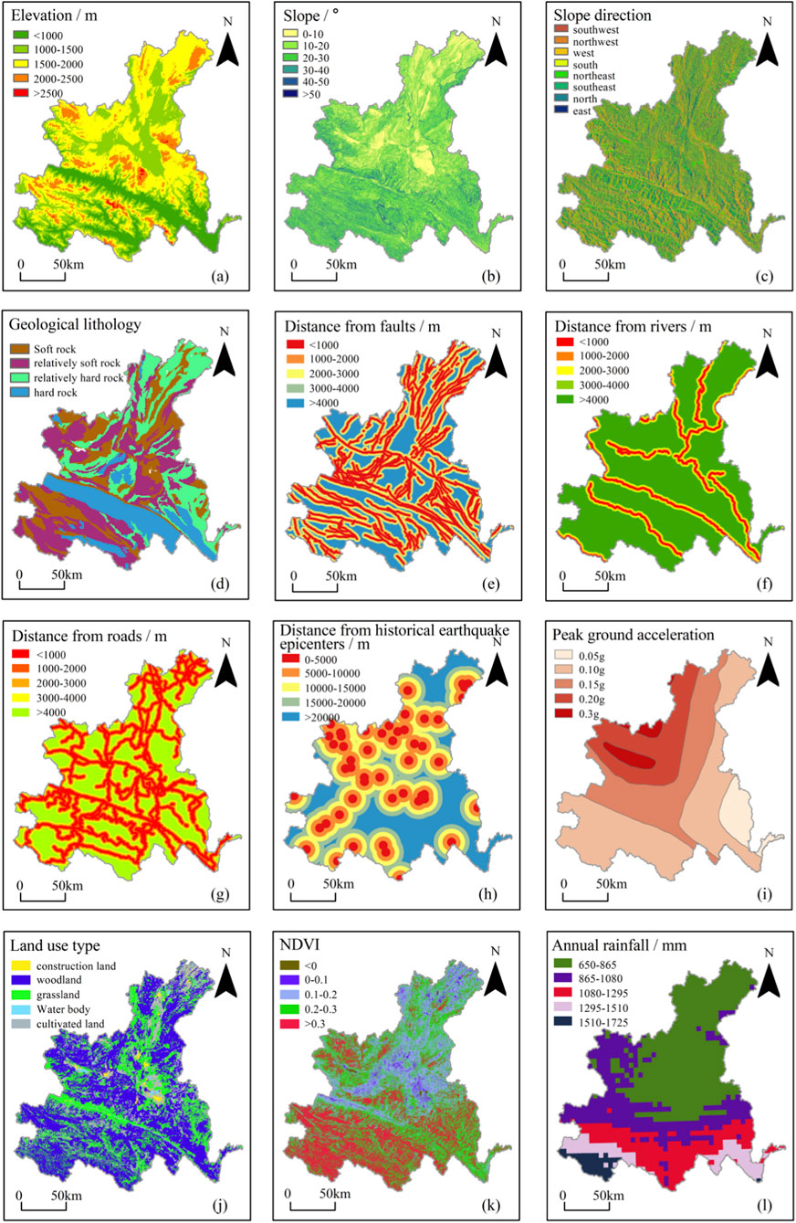
Figure 2. Hazard classification of evaluation indices, (a) Elevation, (b) Slope, (c) Slope direction, (d) Geological lithology, (e) Distance from faults, (f) Distance from rivers, (g) Distance from main roads, (h) Distance from historical earthquake epicenters, (i) Peak ground acceleration, (j) Land use type, (k) NDVI, (l) Annual rainfall.
3.3 Superposition of information quantity model
The information quantities of each evaluation index were calculated using Formula 1, and the results are shown in Table 3.
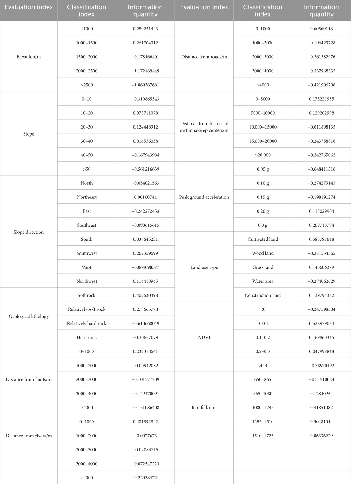
Table 3. Information quantities of hazard evaluation indices.
The total information quantity was obtained by summing the information quantities of each evaluation factor using the field calculator tool in the ArcGIS attribute table, with the maximum value of 3.78778 and the minimum value of −5.28537. Based on the natural breaks method, boundaries were set at positions with relatively large differences in data values to maximize differences between classes. The total information quantity was divided into five levels: low hazard [−5.29, −2.19], relatively low hazard [−2.19, −1.19], medium hazard [−1.19, −0.34], relatively high hazard [−0.34, 0.62], and high hazard [0.62, 3.79].
Finally, Kriging interpolation was performed using the interpolation analysis tool in spatial analysis, and the seismic geological hazard zoning results were obtained through superposition analysis, as shown in the Figure 3.
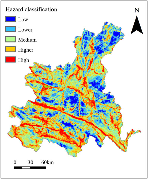
Figure 3. Zoning results of seismic geological hazard in Honghe Prefecture.
Through the calculation and analysis of information quantities of each evaluation factor, the impact degree of each factor on seismic geological hazards can be explored in depth. The calculation results show that most areas in Honghe Prefecture are medium hazard zones, accounting for approximately 30%; followed by relatively low hazard zones, accounting for approximately 26%; low hazard zones, medium-high hazard zones, and high hazard zones account for approximately 10%, 22%, and 12% respectively. In addition, the total information quantity in areas near fault zones is relatively high, indicating that fault zones have a significant impact on seismic geological hazards. The main reason is that Honghe Prefecture is dominated by mountainous landforms, and disasters are mainly collapses, landslides, and debris flows developed along fault lines. Therefore, in areas with high hazard levels around fault zones, tailings pond dams are at high risk of cracks, landslides, or even dam failure.
3.4 Division of target layer, criterion layer, and index layer
To conduct tailings pond seismic hazard analysis using AHP, it is first necessary to clarify the evaluation target (Zheng et al., 2021), i.e., to accurately assess the possibility of tailings ponds suffering disasters under seismic action, providing a scientific basis for tailings pond safety management and disaster prevention. Around this target, various evaluation factors affecting tailings pond seismic hazard are identified, which constitute the criterion layer and index layer in the subsequent hierarchical structure model (Pourghasemi et al., 2012; Sur et al., 2020). First, the evaluation of tailings pond seismic hazard is taken as the target layer; second, factors affecting tailings pond seismic hazard, including seismic geological hazard impact and field investigation and data information, are taken as the criterion layer; and specific indices under each criterion layer, such as the seismic geological hazard level zone where the tailings pond is located, the seismic fortification level of the tailings pond, and whether there are residential areas or important facilities downstream of the tailings pond, are taken as the index layer, forming a multi-level analysis structure. This hierarchical structure helps to clearly express various factors in the problem and their relationships.
The specific hierarchical structure model is shown in the Figure 4.
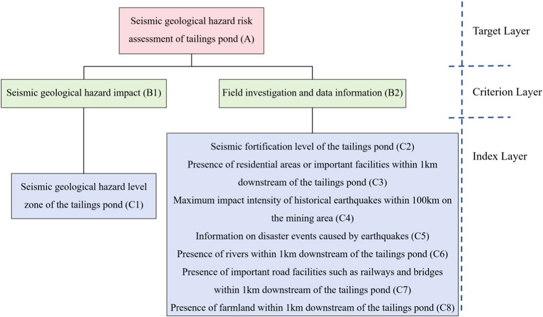
Figure 4. Hierarchical structure diagram.
Seismic geological hazard impact includes the index of the seismic geological hazard level zone where the tailings pond is located. A higher hazard level of the zone indicates that geological hazards are more likely to occur when an earthquake strikes, and the tailings pond dam is vulnerable to damage from geological hazards. In field investigation and data information, a higher seismic fortification level means that the dam is less likely to deform or be damaged under seismic action. If there are residential areas or important facilities, rivers, important road facilities, farmland, etc., downstream of the tailings pond, the scope and degree of harm caused by dam failure will be greater. A higher seismic intensity means that the tailings pond is subject to greater gravity and inertial force under seismic action, which is more likely to affect the stability of the tailings pond. Historical earthquake disaster events can reflect whether the tailings pond has suffered partial damage under seismic action.
3.5 Construction of judgment matrix
To obtain accurate data for constructing the judgment matrix, expert scoring was used to evaluate the mutual importance of selected evaluation factors. A total of 10 experts, including 3 professor, 3 associate professors, and 4 senior engineers, were invited to score. For each element in the factor layer, pairwise comparison questions were designed using the 1-9 scale method. The selected experts all have rich experience and profound professional knowledge in related fields such as geological engineering, seismology, and tailings pond safety management, covering university scholars, researchers from research institutions, and technical personnel engaged in tailings pond management for many years. This ensures the reliability and validity of the data, providing a solid data basis for the subsequent construction of the judgment matrix.
In this study, the expert scoring of the Analytic Hierarchy Process (AHP) is a crucial link connecting qualitative factors and quantitative evaluation, and the weights of the 8 factors determined by it provide a basis for the tailings pond hazard model. Therefore, this study invited multiple experts from different fields to conduct multiple rounds of scoring, and combined specific data such as the ground motion parameter zoning map of the Yunnan Earthquake Agency. Historical disaster data (such as records of past earthquake-induced secondary disasters of tailings ponds in Honghe Prefecture) were used to calibrate the rationality of expert weights, the correlation between factors and historical dam failure events was analyzed, and objective data were used to assist in assignment, reducing reliance on pure subjectivity. By optimizing the composition of experts, conducting multiple rounds of scoring, performing objective calibration, and carrying out sensitivity analysis, the subjectivity and uncertainty of the AHP can be effectively alleviated, making the evaluation results more scientific and practically valuable.
Combined with the actual seismic hazard evaluation factors in the study area, each factor was scored based on the 1-9 scale and expert opinions, and the judgment matrix was constructed as shown in Table 4.
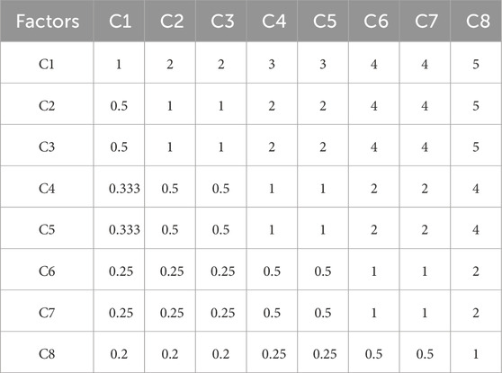
Table 4. Judgment matrix of evaluation factors.
3.6 Weight calculation and consistency test
Based on 8 evaluation factors for tailings pond seismic hazard, the sum-product method in SPSS was used to calculate the weights of evaluation factors and conduct consistency tests. The evaluation factors, eigenvectors, weight values, and maximum eigenvalues are shown in Table 5.
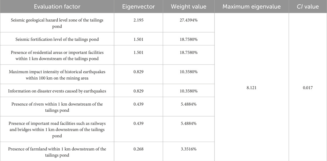
Table 5. Evaluation factors and weights.
The maximum eigenvalue λmax obtained from the analysis of various evaluation factors is 8.121. The consistency test of the judgment matrix is shown in Table 6.
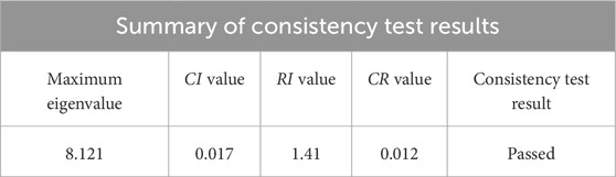
Table 6. Consistency test results.
The calculation results show that the CR value of the 8 evaluation factors after consistency test is less than 0.1, indicating that each judgment matrix has good consistency and passes the consistency test. The judgment matrix results show that the factor of the seismic geological hazard level zone where the tailings pond is located has a relatively high weight, indicating that it has a significant impact on tailings pond seismic hazard. The combined weights of indices such as the seismic fortification level of the tailings pond, the presence of residential areas or important facilities downstream, and the impact intensity of historical earthquakes are relatively large, indicating that these indices play important roles in tailings pond seismic hazard evaluation. These weight results will provide an important basis for the subsequent construction of the tailings pond seismic hazard evaluation model.
4 Results
4.1 Evaluation model
The core goal of this study is to accurately and comprehensively evaluate the seismic hazard of tailings ponds in Honghe Prefecture. As key facilities in mining production, tailings ponds, once suffering disasters such as dam failure and leakage under seismic action, will cause immeasurable losses to the ecological environment, residents’ lives and property, and social and economic development in surrounding areas. Accurately assessing their seismic hazard can provide a scientific and reliable basis for tailings pond safety management, disaster prevention, and emergency decision-making. Through evaluation, the potential risk levels of different tailings ponds in seismic disasters can be clarified, so as to formulate targeted disaster prevention and mitigation measures, allocate resources reasonably, and prioritize reinforcement, monitoring, and management of high-hazard tailings ponds, minimizing the impact of seismic disasters on tailings ponds and ensuring regional safety and stability.
Based on the identified evaluation factors and GIS spatial analysis results, a tailings pond seismic hazard assessment model was constructed. This model considers the impact degree of various hazard factors, quantifies the occurrence probability and potential harm of tailings pond seismic disasters, and classifies the hazard of tailings ponds based on hazard assessment results. The calculation formula is shown in Equation 5:
where: L is the seismic hazard index of the tailings pond; a larger value indicates a higher probability of disaster occurrence, n is the number of evaluation factor classifications, xi is the level value corresponding to the ith evaluation factor of the tailings pond, wi is the weight of the ith evaluation factor.
The tailings pond seismic hazard evaluation model calculates and analyzes geological hazard impact information and field investigation information, and the weights of each evaluation factor are determined by AHP. The weights of each factor are shown in Table 7.
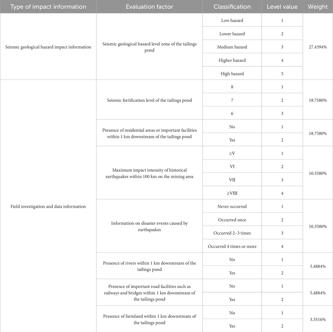
Table 7. Classification of evaluation factors and corresponding weights.
The comprehensive seismic hazard index of each tailings pond was calculated using data obtained from simulation analysis, field investigation, and data statistics. In the calculation process, taking the Zala Lead-Zinc Beneficiation Plant Tailings Pond in Jianshui County, Honghe Prefecture as an example, the xiwi values of each factor were obtained through model calculation: the value of the seismic geological hazard level zone was 0.274394, the value of the seismic fortification level was 0.18758, the value of whether there were residential areas or important facilities downstream was 0.18758, the value of the impact intensity of historical earthquakes was 0.10358, the value of disaster events caused by earthquakes was 0.10358, the value of whether there were rivers downstream was 0.054884, the value of whether there were important road facilities downstream was 0.054884, and the value of whether there were farmland downstream was 0.033516. Therefore, the corresponding hazard index L calculated by the tailings pond seismic hazard evaluation model was 2.388734. By substituting the factor values and weights into all tailings ponds, the comprehensive hazard indices were calculated, and the results are shown in Table 8.
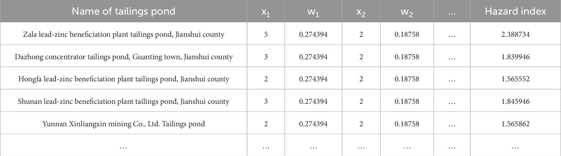
Table 8. Partial examples of tailings pond hazard indices.
Based on the calculation results, the hazard indices of each tailings pond were comprehensively analyzed using the map algebra tool in ArcGIS, and the value range of the tailings pond seismic hazard evaluation index was 1–3.4. Based on the natural breaks method, it was reclassified into 5 levels: low hazard (<1.5), lower hazard (1.5–2), medium hazard (2–2.5), higher hazard (2.5–3), and high hazard (>3). The quantity and proportion of tailings pond hazard classifications are shown in the Figure 5.
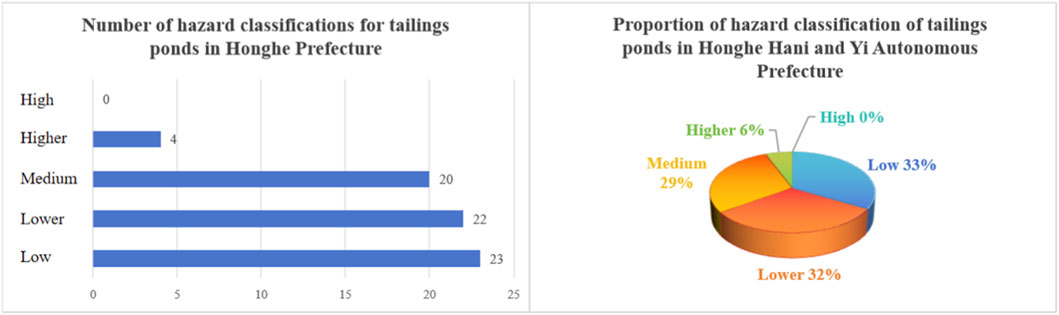
Figure 5. Quantity and proportion of tailings pond hazard classifications in Honghe Prefecture.
To clarify the sensitivity of hazard classification, this study conducted a test by simulating the impact of seismic intensity on the hazard index using the controlled variable method. The results are as follows: the impacts of different historical seismic intensities on tailings ponds were classified and considered in combination with the seismic fortification level of tailings ponds and the scale of dam bodies, and different impact weight proportions were assigned under different seismic intensities. For the sensitivity simulation of seismic intensity scenario changes, four seismic intensity scenarios (VI, VII, VIII, and IX degrees) were set. With other parameters fixed, the changes in the hazard level distribution of tailings ponds in Honghe Prefecture were calculated. When the intensity increased from VI to IX degrees, the number of high-hazard tailings ponds (L > 3) increased from 0 to 5 (accounting for 6.6%), and the number of medium-high hazard tailings ponds (L > 2.5) increased from 4 to 16 (accounting for 21.1%). The key change node was VIII degrees; when the intensity was ≥VIII degrees, the historical seismic impact intensity (C4) grade value of tailings ponds in eastern Gejiu City and southern Jianshui County (originally medium-hazard areas) increased from 3 to 4, and the hazard index increased by an average of 0.32. This proves that the hazard classification is sensitive to high-intensity earthquakes, and focus should be placed on the prevention and control of tailings ponds in areas where the seismic intensity is ≥VIII degrees.
4.2 Discussion
In this study, the information value model and the Analytic Hierarchy Process (AHP) were coordinated through hierarchical integration and functional complementarity, with the core logic being that the information value model quantifies objective correlations and AHP determines subjective importance. On one hand, the information value model was used to calculate the information values of the 12 seismic geological hazard assessment indicators, and the total information value (−5.285–3.788) was obtained by superposition. The natural breaks method was adopted to divide the seismic geological hazard risk into 5 levels; this result only reflects the objective correlation between indicators and hazards, serving as the geological hazard base for tailings ponds. On the other hand, the aforementioned seismic geological hazard zoning was incorporated into the AHP hierarchical structure as a key factor. A judgment matrix was constructed through expert scoring, and consistency checks were conducted with the weights of other tailings-specific factors. Finally, integration was achieved using Formula 5, which combines the geological zoning grade values (1–5) with AHP weights. This enables the hazard index L to encompass both objective correlations and subjective importance, avoiding the limitations of a single method.
By means of weighted summation, the results of the information quantity model and AHP were organically integrated, making the comprehensive evaluation results not only reflect the objective correlation between various environmental factors and tailings pond seismic disasters but also reflect the relative importance of various human impact factors. This integration method improves the scientificity and accuracy of the evaluation results, providing a more reliable basis for the subsequent analysis and prevention of tailings pond seismic hazard.
In ArcGIS software, based on the obtained tailings pond data, spatial visualization was performed to obtain the seismic hazard classification map of tailings ponds in Honghe Prefecture, as shown in the Figure 6. GIS spatial analysis shows that medium and higher hazard zones are concentrated in 3 areas: eastern Gejiu City (7 ponds); southern Jianshui County (11 ponds); southern Mile City (4 ponds).
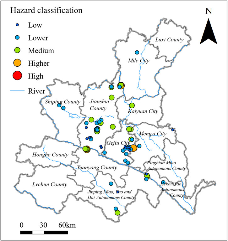
Figure 6. Seismic hazard classification map of tailings ponds in Honghe Prefecture.
A comprehensive evaluation of the seismic hazard of tailings ponds in different regions of Honghe Prefecture reveals obvious characteristics in their distribution. In the concentration area of medium and relatively high hazard tailings ponds in eastern Gejiu City, due to its location near the Gejiu Fault Zone, the geological structure is complex, seismic activities are frequent and intense, and there are a large number of tailings ponds in this area. Some tailings ponds have large dam heights and certain safety hazards in dam structures, and some have been affected to varying degrees in historical earthquakes. These factors lead to generally high seismic hazard of tailings ponds in this area, with concentrated distribution of medium and relatively high hazard tailings ponds.
In the concentration area of medium and high hazard tailings ponds in southern Jianshui County, which is close to the Honghe Fault Zone, there are a large number of tailings ponds. Some tailings ponds were built earlier with low design standards and defective dam structures. The dam slopes of some tailings ponds are steep, and the compaction degree of dam materials is insufficient, making them prone to landslides and deformation under seismic action, resulting in high comprehensive hazard indices. Some tailings ponds have large dam heights, such as the Jianshui Mingtai Mining Co., Ltd. Tailings Pond with a dam height of 60 m. The dam is subject to large gravity and inertial force during earthquakes, and once dam failure occurs, the scope and degree of harm will be very serious.
In the concentration area in southern Mile City, in terms of seismic activity parameters, the peak ground acceleration in this area is relatively large, and it has been affected by strong ground motion many times in historical earthquakes. The higher peak ground acceleration increases the inertial force on the tailings pond dam, making the dam structure more vulnerable to damage.
According to historical earthquake data, the 1970 Tonghai Ms7.7 earthquake in Honghe Prefecture caused cracks and partial landslides in the dams of 3 tailings ponds (archival data of Yunnan Earthquake Agency). The hazard levels of these affected tailings ponds in this study are all medium to relatively high, which fully correspond to the historical damage situation. Among them, the dam of the Mingtai Mining Tailings Pond in Jianshui County (with a hazard index of 2.679894 in this study) was damaged and suffered a landslide during this earthquake. The peak ground acceleration in the area where it is located is 0.20 g, and the distance to the fault zone is less than 1,000 m, which is consistent with the parameters of the hazard model constructed in this study, directly demonstrating the retrospective verification ability of the evaluation model for historical disasters.
In this study, historical event comparison and statistical cross-validation methods were employed to verify the reliability of hazard zoning. Through the verification using historical events from the Yunnan Earthquake Agency, the actual damage status of 32 tailings ponds within the impact range of 19 earthquakes with Ms ≥ 5.0 was matched with the predicted zoning. Results showed that 87.5% of the damaged tailings ponds were located in the medium-to-relatively high hazard zones, which was consistent with the evaluation model. For statistical cross-validation, 76 tailings ponds were divided into a training set and a validation set at a ratio of 7:3. The consistency rate of the grading results of the training set model for the validation set reached 86.9%, which confirms the stability of the model.
Overall, the seismic hazard of tailings ponds in Honghe Prefecture shows obvious spatial differences. Medium and higher hazard tailings ponds are mainly concentrated in areas with complex geological structures and frequent seismic activities, as well as areas with poor conditions of tailings ponds themselves. In contrast, low and lower hazard tailings ponds are mostly distributed in areas with stable geological conditions and weak seismic activities. This distribution characteristic provides an important basis for relevant departments to formulate targeted disaster prevention and mitigation measures.
4.3 Prevention and control strategies
According to the damage degree of tailings ponds and the loss of structural functions, combined with the classification results of the hazard evaluation model, the damage status of tailings pond seismic disasters is divided into 5 levels. The specific classification is shown in Table 9.
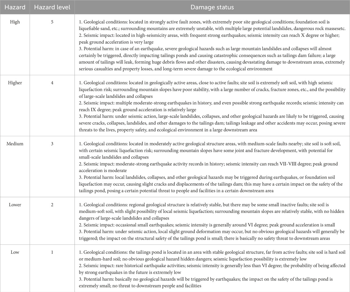
Table 9. Classification of tailings pond hazard and damage status.
According to the hazard classification results of tailings ponds in Honghe Prefecture, there are 23 low-hazard tailings ponds (L ≤ 1.5), accounting for 33%. These tailings ponds are located in areas with stable geological structures, no obvious geological hazard hidden dangers, and basically no geological hazards will be triggered by earthquakes, with extremely small impact on the safety of tailings ponds. There are 22 relatively low-hazard tailings ponds (1.5 < L ≤ 2), accounting for 32%, which are located in areas with relatively stable geological structures, occasional small earthquakes, generally no obvious geological hazards, small impact on the structural safety of tailings ponds, and basically no safety threat to downstream areas. There are 20 medium-hazard tailings ponds (2 < L ≤ 2.5), accounting for 29%, located in areas with relatively active geological structures; local geological hazards may be triggered during earthquakes, which may affect the safety of tailings ponds and pose a certain potential threat to people and facilities in a certain downstream area. There are 4 relatively high-hazard tailings ponds (2.5 < L ≤ 3), accounting for 6%, mainly distributed in the core area of fault zones; these tailings ponds are located in geologically active areas with multiple moderate-strong earthquakes in history; under seismic action, large-scale geological hazards are likely to be triggered, causing relatively severe damage to the tailings dam, and posing a great threat to the lives, property safety, and ecological environment in a large downstream area. There are no high-hazard tailings ponds (L > 3), accounting for 0%.
For tailings ponds in these medium and relatively high hazard areas, a series of targeted measures need to be taken. It is necessary to strengthen the monitoring and maintenance of tailings pond dams, increase the quantity and types of monitoring equipment, improve monitoring frequency, promptly detect safety hazards such as dam deformation and cracks, and take effective reinforcement measures. Reinforce the dam with geotextiles to improve its anti-sliding stability; grout cracks to prevent further expansion. Scientifically calculate and design the dam slope to ensure that the dam can remain stable under seismic action.
Monitoring equipment shall be rationally deployed around tailings ponds to form a sound monitoring network. The monitoring and early warning of seismic activities shall be strengthened, and seismic early warning information shall be promptly released to tailings pond managers and surrounding residents to make emergency preparations in advance. A seismic early warning information release platform shall be established to ensure that early warning information is transmitted to tailings pond managers and surrounding residents quickly and accurately, thus gaining more emergency response time. The analysis and research on seismic monitoring data shall be enhanced to promptly grasp the laws of seismic activities, providing a scientific basis for the seismic design and safety management of tailings ponds.
The operation and management of tailings ponds shall be optimized, and the discharge height and slope of tailings shall be reasonably controlled to reduce the pressure on the dam. Scientific and rational emergency plans shall be formulated to clarify the emergency response procedures, the responsibilities of various departments and personnel, and emergency rescue measures in the event of an earthquake. The emergency plans shall cover contents such as emergency organizations, emergency response levels, emergency disposal measures, personnel evacuation plans, and material guarantees, so as to ensure that rescue work can be carried out rapidly and orderly when a seismic disaster occurs. Emergency drills shall be organized regularly to verify the feasibility and effectiveness of the emergency plans, and improve the emergency response capabilities and self-protection awareness of tailings pond managers and surrounding residents.
For tailings ponds with limited active fault zone data, early warning prevention or monitoring adjustments can be implemented based on actual conditions. Given that geological conditions vary across different regions, it is necessary to integrate local geological characteristics, appropriately add or remove relevant data, and focus on prevention for different aspects. Methods such as dynamic monitoring, data substitution, and analogy can be adopted for auxiliary decision-making. For instance, real-time data from seismic networks and GNSS dam displacement monitoring can be integrated for dynamic early warning; once triggered, information is pushed through a cloud platform, and a simplified emergency plan is activated simultaneously. Surface deformation data can be obtained via remote sensing data inversion on the GEE platform; fault zone parameters can be acquired by comparing similar geological structure areas using the analogy method; and historical event data can be supplemented through community surveys. By enriching the dataset from multiple channels and perspectives, the scientificity of hazard zoning is enhanced. Based on the evaluation results, hierarchical management of tailings ponds should be conducted, and regular emergency drills should be organized for staff and surrounding residents. A comprehensive assessment should be carried out once a year for high-hazard tailings ponds and once every 3 years for low-hazard ones. Additionally, a cross-regional data sharing platform should be established to support the planning and management of tailings ponds.
5 Conclusion
Based on multi-source remote sensing data, basic geological data, and field investigation data, this paper selected and extracted 12 evaluation indices for seismic geological hazards and 8 evaluation factors for tailings pond seismic hazards, and evaluated the seismic hazard of tailings ponds in Honghe Prefecture, with the following conclusions:
1. This study successfully established a comprehensive evaluation model for tailings pond seismic hazard based on GIS spatial analysis, information quantity model, and AHP. Through comprehensive collection and in-depth analysis of relevant data of tailings ponds in Honghe Prefecture, the information quantity model was used to quantitatively analyze multiple indices affecting seismic geological hazards, such as topography, lithology, and seismic parameters, measuring the correlation between each evaluation index and the occurrence of seismic disasters. AHP was used to construct a weight model for tailings pond seismic hazard evaluation, and the relative weights of each evaluation factor were determined through expert scoring and judgment matrix calculation, realizing the organic combination of qualitative and quantitative analysis.
2. Based on this comprehensive evaluation model, a systematic evaluation of the seismic hazard of tailings ponds in Honghe Prefecture was conducted. The distribution characteristics of tailings pond seismic hazard in different regions were clarified: medium and relatively high hazard tailings ponds are mainly concentrated in areas with complex geological structures and frequent seismic activities, such as Xicheng Town and Kafang Town in Gejiu City near the Gejiu Fault Zone, and some areas in Jianshui County near the Honghe Fault Zone. Affected by complex geological conditions and intense seismic activities, coupled with structural and management problems of some tailings ponds themselves, these areas have a high probability of seismic disasters. In contrast, low and relatively low hazard tailings ponds are mostly distributed in areas with stable geological conditions and weak seismic activities. A key analysis of relatively high hazard areas revealed the internal reasons for their high seismic hazard, providing a basis for formulating targeted prevention and control measures.
3. Based on the evaluation results, a series of targeted and operable prevention and control strategies for tailings pond seismic hazards were proposed. Technologies such as dam reinforcement with geotextiles and grouting were adopted to improve dam stability; advanced monitoring equipment was installed and an intelligent monitoring system was established to grasp the dam safety status in real time; seismic monitoring and early warning systems were strengthened, early warning information was released in advance, scientific and reasonable emergency plans were formulated, and regular drills were organized to improve emergency response capabilities; communication and collaboration with surrounding communities and relevant departments were strengthened, and an emergency linkage mechanism was established. These prevention and control strategies are of great practical significance for reducing the seismic hazard risk of tailings ponds in Honghe Prefecture and ensuring the safety of people’s lives and property and the stability of the ecological environment.
Data availability statement
The original contributions presented in the study are included in the article/supplementary material, further inquiries can be directed to the corresponding author.
Author contributions
SiL: Writing – review and editing, Writing – original draft. YC: Writing – review and editing. XH: Writing – review and editing. YX: Writing – review and editing. ML: Writing – review and editing. ShL: Writing – review and editing.
Funding
The authors declare that financial support was received for the research and/or publication of this article. This work was supported by [The Key Science and Technology Program of the Ministry of Emergency Management of the People’s Republic of China] (Grant numbers [2024EMST040405]).
Conflict of interest
The authors declare that the research was conducted in the absence of any commercial or financial relationships that could be construed as a potential conflict of interest.
Generative AI statement
The authors declare that Generative AI was used in the creation of this manuscript. We used ChatGPT (OpenAI) to improve the language and readability of the manuscript. All scientific content, interpretation, and conclusions are solely those of the authors.
Any alternative text (alt text) provided alongside figures in this article has been generated by Frontiers with the support of artificial intelligence and reasonable efforts have been made to ensure accuracy, including review by the authors wherever possible. If you identify any issues, please contact us.
Publisher’s note
All claims expressed in this article are solely those of the authors and do not necessarily represent those of their affiliated organizations, or those of the publisher, the editors and the reviewers. Any product that may be evaluated in this article, or claim that may be made by its manufacturer, is not guaranteed or endorsed by the publisher.
References
Ahmad, S., Rizvi, Z., Arsalan Khan, M., Ahmad, J., and Wuttke, F. (2019). Experimental study of thermal performance of the backfill material around underground power cable under steady and cyclic thermal loading. Mater. Today. Proc. 17, 85–95. doi:10.1016/j.matpr.2019.06.404
Ahmad, S., Rizvi, Z. H., Arp, J. C. C., Wuttke, F., Tirth, V., and Islam, S. (2021). Evolution of temperature field around underground power cable for static and cyclic heating. Energies 14 (23), 8191–19. doi:10.3390/en14238191
Ahmad, M. N., Shao, Z., Aslam, R. W., Ahmad, I., Liao, M., Li, X., et al. (2022). Landslide hazard, susceptibility and risk assessment (HSRA) based on remote sensing and GIS data models: a case study of muzaffarabad Pakistan. Stoch. Env. Res. Risk. A 36 (12), 4041–4056. doi:10.1007/s00477-022-02245-8
Ahmad, S., Ahmad, S., Akhtar, S., Ahmad, F., and Ansari, M. A. (2025a). Data-driven assessment of corrosion in reinforced concrete structures embedded in clay dominated soils. Sci. Rep. 15 (1), 22744–17. doi:10.1038/s41598-025-08526-w
Ahmad, S., Rizvi, Z. H., and Wuttke, F. (2025b). Unveiling soil thermal behavior under ultra-high voltage power cable operations. Sci. Rep. 15 (1), 7315–7317. doi:10.1038/s41598-025-91831-1
Akbarzadeh, A., Radfar, S., and Bafti, S. S. (2024). Evaluation of high-risk dynamic ZoneszCausec by Kinemktic Brittbe Defordation in Northnastern Kerman. Civ. Geoengineering Lett. 1 (2), 1–12. doi:10.22034/CGEL.1.2.e100016
Aswathi, T. S., and Jakka, R. S. (2024). Seismic analysis of hybrid tailings dams: insights into stability and responses. B. Eng. Geol. Environ. 83 (2), 56–23. doi:10.1007/s10064-024-03541-z
Bopche, L., and Rege, P. P. (2022). Landslide susceptibility mapping: an integrated approach using geographic information value, remote sensing, and weight of evidence method. Geotechnical Geol. Eng. 40 (6), 2935–2947. doi:10.1007/s10706-022-02070-4
Chang, M., Cui, P., Xu, L., and Zhou, Y. (2022). The spatial distribution characteristics of coseismic landslides triggered by the Ms7.0 lushan earthquake and Ms7.0 Jiuzhaigou earthquake in southwest China. Environ. Sci. Pollut. Res. Int. 28 (16), 20549–20569. doi:10.1007/s11356-020-11826-5
Chawla, A., Pasupuleti, S., Chawla, S., Rao, A. C. S., Sarkar, K., and Dwivedi, R. (2019). Landslide susceptibility zonation mapping: a case study from darjeeling district, eastern himalayas, India. J. Indian. Soc. Remote. 47 (3), 497–511. doi:10.1007/s12524-018-0916-6
Chen, C., and Ma, B. (2022). Safety assessment of dam failure of tailings pond based on variable weight method: a case study in China. Min. Metall. Explor 39 (6), 2401–2413. doi:10.1007/s42461-022-00686-x
Chen, W., Li, W., Hou, E., Zhao, Z., Deng, N., Bai, H., et al. (2014). Landslide susceptibility mapping based on GIS and information value model for the chencang district of Baoji, China. Arab. J. Geosci. 7 (11), 4499–4511. doi:10.1007/s12517-014-1369-z
Chen, C., Zhao, Y., and Ma, B. (2023). Three-dimensional risk matrix for risk assessment of tailings storage facility failure: theory and a case study. Geotech. Geol. Eng. 42 (3), 1811–1833. doi:10.1007/s10706-023-02647-7
Chen, J., Guo, Q., Yang, J., Luo, J., and Wang, L. (2025). Seismic landslide susceptibility assessment based on game theory combination weighting and information volume model: a case study of luding earthquake high-intensity area. Sādhanā 50 (1), 6–20. doi:10.1007/s12046-024-02652-3
Cheng, D., Cui, Y., Li, Z., and Iqbal, J. (2021). Watch out for the tailings pond, a sharp edge hanging over our heads: lessons learned and perceptions from the brumadinho tailings dam failure disaster. Remote. Sens. 13 (9), 1775–22. doi:10.3390/rs13091775
Dehghananari, M. (2025). Seismic hazard mapping of southern Kerman using GIS: Integiating Activa Geostguctural Featufes. Civ. Geoengin. Lett. 2 (2), 1–13. doi:10.22034/CGEL.2.2.e100038
Devara, M., Tiwari, A., and Dwivedi, R. (2021). Landslide susceptibility mapping using MT-InSAR and AHP enabled GIS-based multi-criteria decision analysis. Geomat. Nat. Haz. Risk. 12 (1), 675–693. doi:10.1080/19475705.2021.1887939
Ding, D., Wu, Y., Wu, T., and Gong, C. (2025). Landslide susceptibility assessment in Tongguan district Anhui China using information value and certainty factor models. Sci. Rep. 15 (1), 12275. doi:10.1038/s41598-025-93704-z
Du, G.-L., Zhang, Y.-S., Iqbal, J., Yang, Z.-H., and Yao, X. (2017). Landslide susceptibility mapping using an integrated model of information value method and logistic regression in the Bailongjiang watershed, Gansu province, China. J. Mt. Sci. 14 (2), 249–268. doi:10.1007/s11629-016-4126-9
Fentahun, T. M., Bagyaraj, M., Melesse, M. A., and Korme, T. (2021). Seismic hazard sensitivity assessment in the Ethiopian rift, using an integrated approach of AHP and DInSAR methods. Egypt. J. Remote. Sens. Space. Sci. 24 (3), 735–744. doi:10.1016/j.ejrs.2021.05.001
Jena, R., Pradhan, B., Beydoun, G., Al-Amri, A., and Sofyan, H. (2020). Seismic hazard and risk assessment: a review of state-of-the-art traditional and GIS models. Arab. J. Geosci. 13 (2), 50–21. doi:10.1007/s12517-019-5012-x
Kang, J., Kang, T., Lee, K., Kim, H., and Shin, J. (2024). Static analysis-based rapid fire-following earthquake risk assessment method using simple building and GIS information. Sci. Rep. 14 (1), 21492. doi:10.1038/s41598-024-72363-6
Kavzoglu, T., Sahin, E. K., and Colkesen, I. (2013). Landslide susceptibility mapping using GIS-based multi-criteria decision analysis, support vector machines, and logistic regression. Landslides 11 (3), 425–439. doi:10.1007/s10346-013-0391-7
Lai, F., Shao, Q., Lin, Y., Yi, X., Sun, X., Shao, H., et al. (2019). A method for the hazard assessment of regional geological disasters: a case study of the panxi area, China. J. Spat. Sci. 66 (1), 143–162. doi:10.1080/14498596.2019.1606741
Lai, C. G., Bozzoni, F., Conca, D., Famà, A., Özcebe, A. G., Zuccolo, E., et al. (2020). Technical guidelines for the assessment of earthquake induced liquefaction hazard at urban scale. B. Earthq. Eng. 19 (10), 4013–4057. doi:10.1007/s10518-020-00951-8
Li, B., Wang, N., Chen, J., and Ji, J. (2021). GIS-Based landslide susceptibility mapping using information, frequency ratio, and artificial neural network methods in Qinghai province, Northwestern China. Adv. Civ. Eng. 2021 (1), 4758062–14. doi:10.1155/2021/4758062
Li, R., Tan, S., Zhang, M., Zhang, S., Wang, H., and Zhu, L. (2024). Geological disaster susceptibility evaluation using a random forest empowerment information quantity model. Sustainability 16 (2), 765–18. doi:10.3390/su16020765
Li, S., Qing, Y., Li, N., Lu, N., Yang, S., Xu, Y., et al. (2025). Geomorphologic feature and its tectonic significance in the middle and upper reaches of Yunnan section of the lancang river basin. Front. Earth. Sci. 13, 1594817–1594821. doi:10.3389/feart.2025.1594817
Lyu, H.-M., Shen, J., and Arulrajah, A. (2018). Assessment of geohazards and preventative countermeasures using AHP incorporated with GIS in lanzhou, China. Sustainability 10 (2), 304–321. doi:10.3390/su10020304
Mahmoody Vanolya, N., and Jelokhani-Niaraki, M. (2019). The use of subjective–objective weights in GIS-Based multi-criteria decision analysis for flood hazard assessment: a case study in Mazandaran, Iran. GeoJournal 86 (1), 379–398. doi:10.1007/s10708-019-10075-5
Malakar, S., Rai, A. K., and Gupta, A. K. (2022). Earthquake risk mapping in the himalayas by integrated analytical hierarchy process, entropy with neural network. Nat. Hazards. 116 (1), 951–975. doi:10.1007/s11069-022-05706-z
Mao, Z., Shi, S., Li, H., Zhong, J., and Sun, J. (2022). Landslide susceptibility assessment using triangular fuzzy number-analytic hierarchy processing (TFN-AHP), contributing weight (CW) and random forest weighted frequency ratio (RF weighted FR) at the pengyang county, northwest China. Environ. Earth. Sci. 81 (3), 86–33. doi:10.1007/s12665-022-10193-3
Mavroulis, S., Diakakis, M., Kranis, H., Vassilakis, E., Kapetanidis, V., Spingos, I., et al. (2022). Inventory of historical and recent earthquake-triggered landslides and assessment of related susceptibility by GIS-based analytic hierarchy process: the case of cephalonia (ionian islands, Western Greece). Appl. Sci. 12 (6), 2895–34. doi:10.3390/app12062895
Nikvand, V., and Bonab, M. H. (2024). Seismic response analysis of tunnels using a coupled polygonal finite element method. Civ. Geoengin. Lett. 1 (1), 1–15. doi:10.22034/CGEL.1.1.e100009
Noorollahi, Y. (2018). Landslide modelling and susceptibility mapping using AHP and fuzzy approaches. Int. J. Hydrol. 2 (2), 137–148. doi:10.15406/ijh.2018.02.00063
Nyimbili, P. H., Erden, T., and Karaman, H. (2018). Integration of GIS, AHP and TOPSIS for earthquake hazard analysis. Nat. Hazards. 92 (3), 1523–1546. doi:10.1007/s11069-018-3262-7
Owen, J. R., Kemp, D., Lèbre, É., Svobodova, K., and Pérez Murillo, G. (2020). Catastrophic tailings dam failures and disaster risk disclosure. Int. J. Disast. Risk. Re. 42, 1–10. doi:10.1016/j.ijdrr.2019.101361
Panchal, S., and Shrivastava, A. K. (2022). Landslide hazard assessment using analytic hierarchy process (AHP): a case study of national highway 5 in India. Ain. Shams. Eng. J. 13 (3), 101626–11. doi:10.1016/j.asej.2021.10.021
Pourghasemi, H. R., Pradhan, B., and Gokceoglu, C. (2012). Application of fuzzy logic and analytical hierarchy process (AHP) to landslide susceptibility mapping at haraz watershed, Iran. Nat. Hazards. 63 (2), 965–996. doi:10.1007/s11069-012-0217-2
Psomiadis, E., Papazachariou, A., Soulis, K., Alexiou, D.-S., and Charalampopoulos, I. (2020). Landslide mapping and susceptibility assessment using geospatial analysis and Earth observation data. Land 9 (5), 133–26. doi:10.3390/land9050133
Qazi, A., Singh, K., Vishwakarma, D. K., and Abdo, H. G. (2023). GIS based landslide susceptibility zonation mapping using frequency ratio, information value and weight of evidence: a case study in kinnaur district HP India. B. Eng. Geol. Environ. 82 (8), 332–24. doi:10.1007/s10064-023-03344-8
Qiao, J., Jiang, Y., Lv, F., Yuan, D., Bakhtari, M. F., Zhang, H., et al. (2025). Study on the susceptibility of geological disasters in loess tableland area of northern Shaanxi based on GIS and information quantity model. All. Earth. 37 (1), 1–15. doi:10.1080/27669645.2025.2477936
Ren, Z., Wang, K., Zhang, Q.-S., Xu, Z.-M., Tang, Z.-G., Chen, J.-P., et al. (2018). Earthquake dynamic response behavior of xiangchong valley type tailings impoundment in Yunnan, China. J. Mt. Sci. 15 (1), 82–99. doi:10.1007/s11629-017-4468-y
Sahar, L., Muthukumar, S., and French, S. P. (2010). Using aerial imagery and GIS in automated building footprint extraction and shape recognition for earthquake risk assessment of urban inventories. Ieee. T. Geosci. Remote. 48 (9), 3511–3520. doi:10.1109/tgrs.2010.2047260
Salari, F. (2025). Seismic hazard assessment of minab city using the preliminary Gutenberg-Richter Methom. Civ. Geoengin. Lett. 2 (2), 1–16. doi:10.22034/CGEL.2.2.e100044
Shadmaan, M. S., and Popy, S. (2023). An assessment of earthquake vulnerability by multi-criteria decision-making method. Geohazard. Mech. 1 (1), 94–102. doi:10.1016/j.ghm.2022.11.002
Shu, B., Liu, Y., Wang, C., Zhang, H., Amani-Beni, M., and Zhang, R. (2024). Geological hazard risk assessment and rural settlement site selection using GIS and random forest algorithm. Ecol. Indic. 166, 112554–18. doi:10.1016/j.ecolind.2024.112554
Sur, U., Singh, P., and Meena, S. R. (2020). Landslide susceptibility assessment in a lesser himalayan road corridor (India) applying fuzzy AHP technique and earth-observation data. Geomat. Nat. Haz. Risk. 11 (1), 2176–2209. doi:10.1080/19475705.2020.1836038
Tan, Q., Huang, Y., Hu, J., Zhou, P., and Hu, J. (2020). Application of artificial neural network model based on GIS in geological hazard zoning. Neural. Comput. Appl. 33 (2), 591–602. doi:10.1007/s00521-020-04987-4
Theilen-Willige, B., Aher, S., Gawali, P., and Venkata, L. (2016). Seismic hazard analysis along Koyna dam area, Western Maharashtra, India: a contribution of remote sensing and GIS. Geosciences 6 (2), 20–19. doi:10.3390/geosciences6020020
Verdugo, R., Sitar, N., Frost, J. D., Bray, J. D., Candia, G., Eldridge, T., et al. (2012). Seismic performance of Earth structures during the February 2010 Maule, Chile, earthquake: dams, levees, tailings dams, and retaining walls. Earthq. Spectra. 28 (1_Suppl. 1), 75–96. doi:10.1193/1.4000043
Villavicencio, G., Espinace, R., Palma, J., Fourie, A., and Valenzuela, P. (2014). Failures of sand tailings dams in a highly seismic country. Can. Geotech. J. 51 (4), 449–464. doi:10.1139/cgj-2013-0142
Wang, Q., Guo, Y., Li, W., He, J., and Wu, Z. (2019). Predictive modeling of landslide hazards in Wen county, northwestern China based on information value, weights-of-evidence, and certainty factor. Geomat. Nat. Haz. Risk. 10 (1), 820–835. doi:10.1080/19475705.2018.1549111
Wang, Y., Kang, L., and Wang, J. (2024). Landslide risk assessment combining kernel extreme learning machine and information value modeling-A case study of Jiaxian country of Loess plateau, China. Heliyon 10 (17), e37352–17. doi:10.1016/j.heliyon.2024.e37352
Wu, Z., Shen, Y., Wang, H., and Wu, M. (2019). Assessing urban flood disaster risk using Bayesian network model and GIS applications. Geomat. Nat. Haz. Risk. 10 (1), 2163–2184. doi:10.1080/19475705.2019.1685010
Wu, M., Ye, Y., Hu, N., Wang, Q., and Tan, W. (2023). Scientometric analysis on the review research evolution of tailings dam failure disasters. Environ. Sci. Pollut. Res. Int. 30 (6), 13945–13959. doi:10.1007/s11356-022-24937-y
Yan, Y., Zhuang, Q., Zan, C., Ren, J., Yang, L., Wen, Y., et al. (2021). Using the Google Earth engine to rapidly monitor impacts of geohazards on ecological quality in highly susceptible areas. Ecol. Indic. 132, 108258–12. doi:10.1016/j.ecolind.2021.108258
Yang, H., Wu, Q., Dong, J., Xie, F., and Zhang, Q. (2023). Landslide risk mapping using the weight-of-evidence method in the datong mining area, Qinghai province. Sustainability 15 (14), 11330–27. doi:10.3390/su151411330
Yousuf, M., Bukhari, S. K., Bhat, G. R., and Ali, A. (2020). Understanding and managing earthquake hazard visa viz disaster mitigation strategies in Kashmir valley, NW Himalaya. Prog. Disaster. Sci. 5, 100064–11. doi:10.1016/j.pdisas.2020.100064
Yu, D., Tang, L., and Chen, C. (2020). Three-dimensional numerical simulation of mud flow from a tailing dam failure across complex terrain. Nat. Hazard. Earth. Sys. 20 (3), 727–741. doi:10.5194/nhess-20-727-2020
Zhai, Y., Chen, S., and Ouyang, Q. (2019). GIS-Based seismic hazard prediction system for urban earthquake disaster prevention planning. Sustainability 11 (9), 2620–12. doi:10.3390/su11092620
Zhang, S., Tan, S., Liu, L., Ding, D., Sun, Y., and Li, J. (2023). Slope rock and soil mass movement geological hazards susceptibility evaluation using information quantity, deterministic coefficient, and logistic regression models and their comparison at Xuanwei, China. Sustainability 15 (13), 10466–19. doi:10.3390/su151310466
Zheng, Q., Lyu, H.-M., Zhou, A., and Shen, S.-L. (2021). Risk assessment of geohazards along Cheng-Kun railway using fuzzy AHP incorporated into GIS. Geomat. Nat. Haz. Risk. 12 (1), 1508–1531. doi:10.1080/19475705.2021.1933614
Zou, H., Ren, B., Deng, X., and Li, T. (2023). Geographic distribution, source analysis, and ecological risk assessment of PTEs in the topsoil of different land uses around the antimony tailings tank: a case study of Longwangchi tailings pond, Hunan, China. Ecol. Indic. 150, 110205–110211. doi:10.1016/j.ecolind.2023.110205
Keywords: seismic hazard, tailings pond, GIS, information quantity model, analytic hierarchy process (AHP)
Citation: Li S, Cao Y, Huang X, Xu Y, Luo M and Li S (2025) Seismic hazard analysis of tailings ponds in Honghe Prefecture based on information quantity model and analytic hierarchy process. Front. Earth Sci. 13:1698729. doi: 10.3389/feart.2025.1698729
Received: 04 September 2025; Accepted: 06 November 2025;
Published: 27 November 2025.
Edited by:
Wenling Tian, China University of Mining and Technology, ChinaReviewed by:
Zarghaam Rizvi, GeoAnalysis Engineering GmbH, GermanyMohammad Azarafza, University of Tabriz, Iran
Copyright © 2025 Li, Cao, Huang, Xu, Luo and Li. This is an open-access article distributed under the terms of the Creative Commons Attribution License (CC BY). The use, distribution or reproduction in other forums is permitted, provided the original author(s) and the copyright owner(s) are credited and that the original publication in this journal is cited, in accordance with accepted academic practice. No use, distribution or reproduction is permitted which does not comply with these terms.
*Correspondence: Yanbo Cao, Njc0NzE0NDE0QHFxLmNvbQ==