 Huang Chao
 Zeng Jianhui1
- 1College of Geosciences, China University of Petroleum, Beijing, China
- 2Research Institute of Exploration and Development, Shengli Oilfield Company, SINOPEC, Dongying, China
The physical property boundary between conventional low-permeability and unconventional tight sandstone oil reservoirs is generally defined at a permeability of 1 × 10⁻³ μm2. Understanding the reservoir characteristics and hydrocarbon enrichment patterns within this transitional zone is of significant importance for the comprehensive evaluation of the whole petroleum system. This study investigates the petrology, physical properties, and microscopic pore-throat structures of this transition zone using core analysis data from four cored wells of the Jishan Sandstone in the Shang 541 area, located in the Huimin Sag of the Jiyang Depression. Furthermore, it analyzes the oil-bearing characteristics and controlling factors by integrating drilling results from 13 wells, core water-drop tests, and core oil saturation measurements. The reservoirs in the study area are composed of lithic arkose, with intergranular dissolution pores and primary intergranular pores as the dominant storage space types. Petrophysical properties are strongly influenced by burial depth, causing the reservoir to transition from a conventional low-permeability system in the west to a tight system in the east as depth increases. The transitional zone reservoirs exhibit an average pore-throat radius of 0.2–0.3 μm, and a strong positive correlation is observed between permeability and mean pore-throat radius. Areal hydrocarbon distribution is controlled by two primary factors. First, as reservoir quality improves towards shallower depths, the capillary self-sealing effect weakens, leading to a decrease in oil saturation and a shift from oil layers to oil-water and water layers. Second, under a “source-fault-reservoir” lateral contact charging model, enrichment is greatest in proximity to faults. Far from the fault conduit, hydrocarbon expulsion pressure diminishes, preventing effective charge and resulting in water-bearing reservoirs. This research significantly enhances the understanding of enrichment patterns in conventional-unconventional transitional reservoirs and provides valuable guidance for exploration and development in the Jiyang Depression.
1 Introduction
Unlike conventional reservoirs where buoyancy is the dominant trapping force (White I C, 1885), the accumulation of tight oil is a process where capillary and viscous forces exceed buoyancy. This necessitates a different trapping mechanism, primarily the “self-sealing effect” (also known as capillary sealing), where high capillary entry pressures within the fine-grained rock matrix effectively trap hydrocarbons (Jia et al., 2024; Jia et al., 2025). Consequently, tight oil accumulations are typically characterized by their proximity to source rocks, large-scale continuous distribution, lack of distinct trap boundaries, and minimal influence from structural geometry (Sun et al., 2019; Suyun et al., 2019). In November 2017, the People’s Republic of China established a national standard, “Geological Evaluating Methods for Tight Oil” (GB/T34906—2017), which quantitatively defined the boundary for tight oil reservoirs as having a surface air permeability less than or equal to 1 × 10⁻³ μm2 and an in-situ permeability less than or equal to 0.1 × 10⁻³ μm2. This standard provides a clear distinction between tight and conventional resources.
While the enrichment patterns for distinct tight oil and conventional reservoirs have been extensively studied, the characteristics of the transitional zone around the 1 × 10⁻³ μm2 permeability threshold remain poorly understood. The Jishan Sandstone, located within the Huimin Sag of the Jiyang Depression in eastern China, presents an ideal case study. It spans a wide range of burial depths, with significant portions falling within this conventional-to-unconventional transition zone, leading to a complex oil-water distribution and an unclear understanding of enrichment controls.
Historically, geological interpretations in this area have been limited, and previous explanations for the heterogeneity of oil-bearing properties have primarily focused on conventional reservoirs, proposing three main viewpoints: (1) lithological variations, where oil-bearing differences between lithological units are influenced by interbedded sealing layers (Zhang et al., 2002; Zhang, 2006; Sun et al., 2007; Zhang et al., 2021); (2) the reservoir’s pore-throat structure, which significantly affects oil-water distribution, and under specific hydrocarbon accumulation conditions, the peak pore-throat radius determines whether oil and gas can migrate and accumulate within the reservoir (Zhang et al., 2007); (3) diagenetic control, where tight cementation layers formed by diagenesis act as barriers, stratigraphically compartmentalizing oil-bearing properties (Yang, 2006).
The theory of self-sealing in tight reservoirs offers a new framework for re-evaluating the enrichment patterns in the Jishan Sandstone. This paper utilizes an extensive dataset of core analyses and well log data to investigate the petrological, petrophysical, and microscopic pore-throat characteristics of the conventional-unconventional transition zone. By doing so, it aims to clarify the primary controlling factors of hydrocarbon accumulation and establish a robust model for oil and water distribution, which will be of significant value for the exploration and development of similar transitional reservoirs.
2 Regional geological overview
The Jishan Sandstone is a large-scale deltaic system deposited during the middle part of the Shahejie Formation (Es3) in the Huimin Sag, a sub-basin of the Jiyang Depression, sourced from the Chengning Uplift, passing through the Zizhen Sub-depression and the central anticlinal belt, and extending to the northern slope of the Linnan Sub-depression. Stratigraphically, the sandstone is divided into seven sand groups. In plan view, it exhibits a “tongue-shaped” geometry, covering an area of approximately 300 km2.
2.1 The structure contours are the top of sand group 3 of Jishan Sandstone
The study focuses on the Shang 541 area, where the primary reservoir intervals are found in sand groups 3 through 7, at burial depths ranging from 2900 m to 3500 m. The area’s structure is a gentle monocline that rises from southeast to northwest (Figure 1). The depositional environments vary stratigraphically, sand groups 3–4 consist of discontinuously distributed distributary channel sandstones, whereas sand groups 5–7 are composed of thick, laterally continuous mouth bar sandstones. A total of 13 wells have been drilled in the area, with 10 encountering oil layers. However, wells in the west (S541-X56) and south (S544, S547) are predominantly water-bearing. This complex areal distribution of oil and water suggests that structural position is not the primary control on hydrocarbon accumulation, presenting a significant geological anomaly that requires a more nuanced explanation.

Figure 1. Structural map and well location in the Shang 541 block.
3 Data and methods
Among the 13 completed wells in the study area, a total of 4 are cored wells. The foundation of this study is a comprehensive dataset derived from all the 13 wells and a total of 136 m of core provided by the four cored wells in the Shang 541 area (Figure 1). To preserve in-situ fluid saturations, sections of fresh, full-diameter core were immediately sealed with wax upon retrieval. These preserved samples were later used for laboratory analysis of oil saturation. On-site, qualitative assessment of oil distribution was performed on the remaining core using water-drop tests. A comprehensive analytical program was conducted on the core samples, including measurements of porosity and permeability, whole-rock mineralogy via X-ray diffraction (XRD), high-pressure mercury injection (HPMI) for pore-throat characterization, thin section petrography, and scanning electron microscopy (SEM). Porosity and permeability samples were collected at intervals of 2 m from sandstone cores to analyze physical property characteristics. The samples used for analyzing petrological and pore structure characteristics via SEM, thin sections, XRD, and HPI all exhibit permeability ranging from 0.5 to 5mD. All samples used for oil saturation testing were selected based on favorable oil-bearing properties observed on-site. This core-based analysis was supplemented by well log and drilling data from all 13 wells in the study area to build a complete picture of reservoir and fluid characteristics.
The robustness of the dataset is demonstrated by the large number of analyses performed, as summarized in Table 1. This extensive analytical program, with 300 permeability measurements and 127 thin sections, provides a high degree of confidence in the subsequent interpretations of reservoir properties and their impact on hydrocarbon distribution.

Table 1. Testing items and quantities in the Shang 541 Area.
4 Results
4.1 Petrological characteristics
The reservoir rock in the Shang 541 area is classified as a lithic arkose, predominantly composed of fine-to very-fine-grained sand. The framework grains consist of quartz (average 44.8%), feldspar (average 35.1%), and lithic fragments (average 20.1%). Quartz grains are mainly monocrystalline with some chert, exhibiting poor rounding and sub-angular shapes. Feldspars include both potassium feldspar and plagioclase, which are also poorly rounded and often show signs of partial dissolution. The lithic fragments are primarily composed of quartzite and crystalline rock fragments.
The interstitial material filling the space between grains is composed of matrix and cement. The matrix, averaging 7.4% by volume, consists of terrigenous clay minerals and silt-sized detrital particles that either coat grain surfaces or fill intergranular spaces. The cement, averaging around 10% by volume, is dominated by dolomite and calcite.
Due to the high plasticity of feldspar and rock fragments under high-temperature and deeply-buried conditions, the Jishan sandstone formation is deeply buried (2900–3500 m), leading to significant compaction effects on reservoir properties. The deeper the burial depth, the poorer the physical properties.
4.2 Physical property characteristics
The reservoirs in the Shang 541 area exhibit porosities ranging mainly from 8% to 20% and permeabilities from 0.5 × 10⁻³ μm2 to 5 × 10⁻³ μm2.These properties place the reservoir squarely within the transitional zone around the 1 × 10⁻³ μm2 boundary that separates conventional low-permeability and unconventional tight reservoirs.
A distinct trend of deteriorating reservoir quality is observed with increasing burial depth. Below 3250 m, reservoir permeability is consistently less than 1 × 10⁻³ μm2, and porosity is typically below 15% (Figure 2). In the intermediate depth range of 3100–3250 m, permeability varies between 0.4 × 10⁻³ μm2 and 3 × 10⁻³ μm2, with porosity between 12% and 16%. This depth-dependent trend translates into a clear areal pattern due to the regional structure, which deepens from west to east. Consequently, reservoir quality degrades from west to east. The westernmost well, S549, encountered a conventional very-low-permeability reservoir with permeabilities of 3–12 ×10−3 μm2. In contrast, the central and eastern wells, including S541-1, S541-X20, and S548, are all situated in the transitional zone with permeabilities hovering around the 1 × 10⁻³ μm2 threshold.

Figure 2. Distribution of permeability and porosity with depth. (a) Permeability distribution map (b) Porosity distribution map.
4.3 Microscopic pore-throat characteristics
Thin section petrography and SEM analysis reveal that the dominant pore types are intergranular dissolution pores and primary intergranular pores, with minor intragranular dissolution pores within feldspar and lithic grains. The pores are geometrically complex, with triangular, quadrilateral, and irregular shapes (Figure 3a). Overall pore connectivity is poor. The pore throats, which control fluid flow, are primarily sheet-like, with some smaller, point-like constrictions. Fractures are not well-developed. The pore system is significantly impacted by diagenesis, with authigenic minerals such as quartz overgrowths, clay minerals, calcite, and ferroan dolomite frequently occluding both pores and throats (Figures 3b,c).

Figure 3. Photomicrographs of reservoir space and infillings in well S541-X20. (a) Cast thin section from well S541-X20 (3230 m) (b) SEM photomicrographs of well S541-X20 (3333.7 m) (c) SEM photomicrographs of well S541-X20 (3297.3 m).
Quantitative analysis from 16 HPMI samples shows that the mean pore-throat radius ranges from 0.05 μm to 0.6 μm. A strong positive correlation exists between reservoir permeability and the mean pore-throat radius (Figure 4). Specifically, samples with permeability below 1 × 10⁻³ μm2 have a mean pore-throat radius of 0.2–0.3 μm, while samples with permeability between 1 × 10⁻³ μm2 and 2.5 × 10⁻³ μm2 have a larger mean radius of 0.3–0.6 μm. The pore system is highly heterogeneous, as indicated by a sorting coefficient ranging from 0.11 to 0.32 and a coefficient of variation from 0.8 to 1.1.

Figure 4. Variation of permeability versus mean pore-throat radius for S548 and S541-X20 wells.
4.4 Hydrocarbon enrichment patterns
Drilling results from 13 wells reveal a complex spatial distribution of hydrocarbons that defies simple structural explanation. From east to west, the fluid distribution follows a pattern of an oil zone, followed by an oil-water zone, a water zone, and then another oil zone. In the eastern, tighter part of the area, oil accumulations are concentrated near faults and appear independent of structural elevation.
This complexity is best illustrated by comparing key wells along the east-west transect (Figure 5a). The eastern S548 well, located in the tight-transitional zone, is interpreted to be entirely oil-bearing with a net pay of 29.4 m and log-derived oil saturations of 60%–65%. The central S541-1 well, in a similar transitional reservoir, is dominated by oil-water and water zones with lower oil saturations of 50%–55%. The S541-X56 well in the western high-altitude zone, located in the conventional low-permeability portion of the system, is entirely water-bearing. Further west,in the structurally higher T12-2 well, oil layers reappear with a thickness of 12 m and logging-derived oil saturation of approximately 65%. This pattern directly contradicts conventional trapping models where hydrocarbons should accumulate at the highest structural positions.

Figure 5. Reservoir cross-section of SHANG 541 Area (see Figure 1 for location of cross-sections). (a) E-W reservior profile of Shang 541 area (b) S-N reservior profile of Shang 541 area.
The influence of faulting is also evident in the north-south direction (Figure 5b). Oil-bearing layers in the transitional zone are generally confined to a zone within 1000 m of a major fault. Although the existing data are still insufficient to establish a quantitative relationship between distance from the fault and oil saturation, drilling results show that, under conditions of stable sandstone development, well Shang 541 is 250 m from the fault with oil layers’ thickness of 67 m, well Shang 543 is 800 m from the fault with oil layers’ thickness of 28 m, and well Shang 544 is 1,400 m from the fault with pure water layers. It is evident that the farther away from the fault, the less developed the oil-bearing layers become. In the north–south direction, structural highs and lows have no obvious controlling effect on oil-bearing properties. Well S544, for example, is at a similar structural elevation to the oil-bearing S541 well but is located far from the fault and is entirely water-bearing.
Heterogeneity is also pronounced at the core scale. Water-drop tests on a 20 cm core segment from well S541-X20 showed that one end was strongly oil-wet (water beaded up and did not penetrate), while the other end was water-wet (water was immediately absorbed), indicating a sharp gradient in oil saturation over a very short distance (Figure 6a). Quantitative core plug measurements confirm this, with oil saturation values varying widely between 20% and 50%. A critical relationship emerges when plotting oil saturation against permeability (Figure 6b): in the tight portion of the reservoir (permeability <1 × 10⁻³ μm2), oil saturation decreases as permeability increases. Above 1 × 10⁻³ μm2, in the conventional low-permeability domain, oil saturation remains consistently low, typically between 20% and 30%.

Figure 6. Core photos and permeability-oil saturation relationship plot of well S541-X20. (a) Core photographs from well S541-X20 (b) statistical plot of permeability vs. oil saturation relationship.
5 Discussion
5.1 The influence of reservoir physical properties on hydrocarbon enrichment, a self-sealing mechanism
The seemingly paradoxical relationship where oil saturation decreases as reservoir quality improves is a direct manifestation of the transition from a capillary-dominated unconventional system to a buoyancy-dominated conventional system. The governing mechanism is the effectiveness of capillary self-sealing.
In the deeper, eastern part of the study area (e.g., well S548), the reservoir properties fall within the tight oil classification (permeability <1 × 10⁻³ μm2). The small pore throats create very high capillary entry pressures. During hydrocarbon charge, these high pressures form an effective seal, trapping oil within the reservoir matrix and leading to high oil saturations. This is the essence of the self-sealing mechanism.
As one moves westward into shallower, better-quality rock (e.g., well S541-1), the permeability increases and crosses the critical 1 × 10⁻³ μm2 threshold. In this transitional zone, the pore throats are larger, and consequently, the capillary entry pressures are significantly lower. The self-sealing mechanism becomes ineffective or fails entirely. Without the capillary seal to retain them, mobile hydrocarbons are no longer trapped efficiently. The oil saturation drops to residual or immobile levels (20%–30%), which explains the prevalence of oil-water and water-bearing layers in this part of the reservoir.
The hydrocarbons that were not trapped by the failed self-sealing mechanism are now subject to buoyancy forces and are free to continue their migration. This initiates a secondary migration phase, where the oil moves further updip to accumulate in conventional traps, such as the structural closures encountered by wells T12-2 and S549 (Figure 7). This model also explains why well S541-X56, despite being structurally high, is water-bearing, it is located in the conventional part of the system but lies below the newly established oil-water contact for this secondary accumulation.
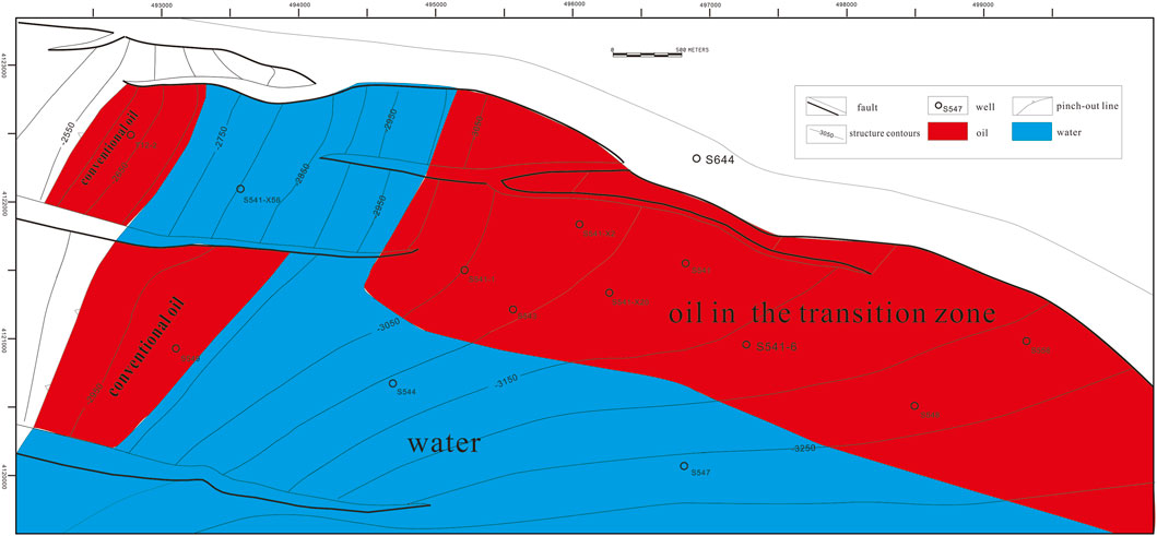
Figure 7. Planar oil-water distribution map of Shang 541 area.
In conclusion, oil-bearing properties are closely related to depth. Above 3100 m, conventional reservoirs dominate, where the oil-water interface primarily controls fluid distribution. Between 3100 and 3250 m, oil-water transition zones are developed, with oil saturation decreasing from 65% to approximately 20% as burial depth shallows. Below 3250 m, tight oil reservoirs exhibit a consistent oil saturation of around 65%.
This reinterpretation completely redefines the exploration strategy for this play. The most prospective targets are not necessarily the rocks with the highest permeability or those at the highest structural crest. Instead, the sweet spot is the zone that is precisely tight enough to provide an effective capillary self-seal while still possessing adequate storage capacity and access to hydrocarbon charge.
5.2 The influence of distance from faults on hydrocarbon enrichment: The source-fault-reservoir charging model
The distribution of hydrocarbons is not only controlled by the reservoir’s ability to trap oil but also by its access to charge. For tight oil systems, which require short migration pathways, the source-reservoir configuration is paramount. The source-reservoir associations of China’s continental tight oil are classified into four types: interbedded source-reservoir type, source-under-reservoir type, source-over-reservoir type, and integrated source-reservoir type (Zhu et al., 2019; Luo et al., 2023). Due to the complex fault system, the source-fault-reservoir lateral connection is another significant source-reservoir assemblage type for tight oil in the eastern China rift basins (Wang et al., 2025).
The specific charging mechanism in the Shang 541 area is a “source-fault-reservoir lateral contact” model. The Jishan Sandstone is charged from the underlying, mature source rocks of the lower Shahejie Formation (Es3). A major normal fault acts as a vertical conduit, juxtaposing the thick source rock in the footwall directly against the reservoir sandstone in the hanging wall. The primary driving force for charging the low-permeability reservoir is the overpressure generated during hydrocarbon maturation and expulsion from the source rock. This pressure-driven charge is a highly localized and inefficient process. The expulsion pressure dissipates rapidly as hydrocarbons move away from the fault conduit into the tight reservoir matrix. Consequently, effective hydrocarbon charge is limited to the portion of the reservoir in close proximity to the fault, empirically determined to be within a radius of approximately 1000 m in this area.
This charging model explains why wells located far from the fault, such as S544 and S547, are entirely water-bearing. Regardless of their reservoir quality or structural position, they were simply too far from the conduit to be charged. This finding has profound implications for exploration. It suggests that the primary exploration fairway is not a broad, structurally defined area but a relatively narrow corridor bounded by the charging fault. Therefore, the most critical exploration tool is not traditional structural mapping but detailed seismic mapping of the fault architecture and its juxtaposition relationships with the reservoir sandstone and the underlying source rock.
Both reservoir quality and distance to faults are critical because the structure uplifts westward and the main fault extends westward. Reservoir quality affects the oil-bearing boundary to the west, while distance to faults controls the oil-bearing boundary to the south.
6 Conclusion
The reservoirs in the Shang 541 area exhibit a systematic degradation of physical properties with increasing burial depth, transitioning from conventional low-permeability sandstones to unconventional tight sandstones. The transitional zone is composed of lithic arkose. Its pore system is dominated by intergranular dissolution and primary intergranular pores, with a mean pore-throat radius ranging from 0.05 μm to 0.6 μm.
Hydrocarbon enrichment is co-controlled by two critical factors, reservoir physical properties and distance from the charging fault. Moving from east to west, as burial depth decreases and reservoir quality improves, the capillary self-sealing effect weakens. This leads to a decrease in oil saturation and causes the reservoir to transition from being primarily oil-bearing to containing oil-water and water zones. The area is charged via a source-fault-reservoir lateral contact model. Hydrocarbon expulsion pressure from the source rock drives oil into the adjacent reservoir. This pressure dissipates with distance, limiting effective charge to reservoirs proximal to the fault. Distal areas remain uncharged and are consequently water-bearing.
Data availability statement
The original contributions presented in the study are included in the article/supplementary material, further inquiries can be directed to the corresponding author.
Author contributions
HC: Data curation, Writing – review and editing, Software, Writing – original draft, Investigation, Conceptualization. ZJ: Methodology, Supervision, Writing – original draft, Writing – review and editing. ZY: Data curation, Investigation, Writing – review and editing.
Funding
The authors declare that financial support was received for the research and/or publication of this article. The study is funded by the research project of Sinopec Corporation (P24021). The funder was not involved in the study design, collection, analysis, interpretation of data, the writing of this article, or the decision to submit it for publication.
Acknowledgements
Sinopec Corporation provided equipment for high-pressure mercury injection tests, scanning electron microscopy tests, and whole-rock mineral analysis.
Conflict of interest
Authors HC and ZY were employed by Shengli Oilfield Company, SINOPEC.
The remaining author declares that the research was conducted in the absence of any commercial or financial relationships that could be construed as a potential conflict of interest.
Generative AI statement
The authors declare that no Generative AI was used in the creation of this manuscript.
Any alternative text (alt text) provided alongside figures in this article has been generated by Frontiers with the support of artificial intelligence and reasonable efforts have been made to ensure accuracy, including review by the authors wherever possible. If you identify any issues, please contact us.
Publisher’s note
All claims expressed in this article are solely those of the authors and do not necessarily represent those of their affiliated organizations, or those of the publisher, the editors and the reviewers. Any product that may be evaluated in this article, or claim that may be made by its manufacturer, is not guaranteed or endorsed by the publisher.
References
Jia, C., Pang, X., and Yan, S. (2024). Basic principles of the whole. Petroleum System Petroleum Explor. Dev. 51 (4), 679–691. doi:10.11698/PED.20240150
Jia, C., Lin, J., and Wen, Z. (2025). Tight oil and gas in whole petroleum system:, accumulation mechanism, enrichment regularity, and resource prospect. Acta Pet. Sin. 46 (1), 1–16. doi:10.7623/syxb202501001
Luo, Q., Lan, H., Yang, G., Yuan, D., Yingyan, L., Wang, S., et al. (2023). Differential mechanism of tight oil enrichment and reservoir controlling model of source and reservoir combinations: a case study of qingxi sag, Jiuquan Basin. Petroleum Geol. and Exp. 45 (1), 1–10. doi:10.11781/sysydz202301001
Sun, Y., Zhong, J., Jiang, Z., Wang, Z., and Gao, X. (2007). Sedimentary features and reservoir-forming conditions of Jishan sand body in Huimin sag. J. Southwest Petroleum Univ. 29 (01), 40-43+141–142. doi:10.3863/j.issn.1674-5086.2007.01.013
Sun, L., Zou, C., Jia, A., Yunsheng, W., Zhu, R., Wu, S., et al. (2019). Development characteristics and orientation of tight oil and gas in China. Petroleum Explor. Dev. 46 (6), 1073–1087. doi:10.1016/s1876-3804(19)60264-8
Suyun, H., Shizhen, T., Weipeng, Y., Guangtian, M., Tang, Z., Xue, J., et al. (2019). Advances on continental tight oil accumulation and key technologies for exploration and development in China. Nat. Gas. Geosci. 30 (8), 1083–1093. doi:10.11764/j.issn.1672-1926.2019.04.018
Wang, Y., Yang, G., Junliang, L., and Zheng, L. (2025). New exploration fields and resource potential of Paleogene clastic tight oil in Jiyang depression, Bohai Bay Basin. Acta Pet. Sin. 46 (1), 118–136. doi:10.7623/syxb202501009
White, I. C. (1885). The geology of natural gas. Science 5 (125), 521–522. doi:10.1126/science.ns-5.125.521
Yang, L. (2006). Sandstone diagenesis and its influences on hydrocarbon traps in Jishan sand-body in Huimin depression, north China. Acta Petrol. Sin. 22 (8), 2205–2212. doi:10.3969/j.issn.1000-0569.2006.08.010
Zhang, X., and Zha, M. (2006). Analysis of the controls on lithologic oil reservoir in Linyi sub sag, Huimin Sag. Acta Sedimentol. Sin. 24 (2), 289–293. doi:10.3969/j.issn.1000-0550.2006.02.018
Zhang, Y., Guiqiang, Q., Chenyi, L., and Cuntang, F. (2002). Exploration trend for litho-oil reservoir in 3rd member of Shahejie formation of Huimin depression. Oil and Gas Geol. 23 (2), 162–165. doi:10.3321/j.issn:0253-9985.2002.02.013
Zhang, X., Ming, Z., and Yi, Y. (2007). Pore structure features of lithologic reservoirs in the third member of Shahejie formation in Huimin sag and their significance in petroleum exploration. Oil and Gas Geol. 28 (2), 287–292.
Zhang, Z., Liu, T., Xie, F., Yang, M., He, R., Liu, Y., et al. (2021). Study on the main controlling factors of hydrocarbon accumulation of Jishan sand body of Es3 in linbei area of Huimin depression. J. Liaoning Petrochem. Univ. 41 (3), 48–56.
Keywords: tight oil, microscopic characteristics, enrichment features, source-reservoir assemblage, transition zone
Citation: Chao H, Jianhui Z and Yuanyuan Z (2025) Reservoir characteristics and enrichment features of the low-permeability to tight transition zone in the Jishan Sandstone, Shang 541 area. Front. Earth Sci. 13:1708691. doi: 10.3389/feart.2025.1708691
Received: 19 September 2025; Accepted: 18 November 2025;
Published: 04 December 2025.
Edited by:
Albert Griera, Autonomous University of Barcelona, SpainReviewed by:
Zhengzheng Cao, Henan Polytechnic University, ChinaSaipeng Huang, Northeast Petroleum University, China
Copyright © 2025 Chao, Jianhui and Yuanyuan. This is an open-access article distributed under the terms of the Creative Commons Attribution License (CC BY). The use, distribution or reproduction in other forums is permitted, provided the original author(s) and the copyright owner(s) are credited and that the original publication in this journal is cited, in accordance with accepted academic practice. No use, distribution or reproduction is permitted which does not comply with these terms.
*Correspondence: Huang Chao, aHVhbmdjaGFvOTUyLnNseXRAc2lub3BlYy5jb20=