 Antony John Lynam1*
 Drew T. Cronin2
 Serge A. Wich3
 Jordan Steward1
 Andrew Howe4
 Namrata Kolla4Michael Markovina5Omar Torrico6
 Vanesa Reyes7
 Kong Sophalrachana8Xia Stevens9
 Eric Schmidt10Henrik Cox11
- 1EarthRanger Program, Allen Institute for Artificial Intelligence, Seattle, WA, United States
- 2International Conservation, North Carolina Zoo, Asheboro, NC, United States
- 3Biological and Environmental Sciences, Liverpool John Moores University, Liverpool, United Kingdom
- 4Skylight Program, Allen Institute for Artificial Intelligence, Seattle, WA, United States
- 5Parcs de Noé, Paris, France
- 6Wildlife Conservation Society - Global Conservation Technology Program, La Paz, Bolivia
- 7Wildlife Conservation Society - Argentina Program, Buenos Aires, Argentina
- 8Wildlife Conservation Society - Cambodia Program, Phnom Penh, Cambodia
- 9Panthera, New York, NY, United States
- 10Wildlife Protection Solutions, Golden, CO, United States
- 11Conservation X Labs, Washington, DC, United States
Introduction: Market-driven poaching and unsustainable wildlife harvest are significant drivers of population decline for numerous plant and animal species, including high-profile species like Asian and African elephants, wild cats, sharks and rays, and pangolins. This publication reviews the emerging role of conservation technology in combating this trade.
Technologies and applications: We showcase how innovative technological tools are revolutionizing the detection and disruption of illegal and unsustainable wildlife trade, with a focus on those available to frontline staff working to prevent poaching and trafficking from source sites. We consider a diverse array of deployed technologies ranging from open-source software platforms, AI, and mobile apps to cutting-edge hardware, including camera traps, acoustic sensors, and remote sensing tools.
Case studies: To demonstrate the complex threats posed by IUWT to wildlife and the consequent need for tailored solutions, we present two case studies, one terrestrial and one marine, showcasing the importance of appropriate suites of technology tools for conservation implementation.
Discussion: Technology has potential to empower rangers, park staff, wildlife and fisheries inspectors, customs officials, police, and conservation practitioners with unprecedented capabilities to monitor threatened wildlife, detect illegal activities, gather evidence, and support law enforcement interventions.
1 Introduction
The illegal and/or unsustainable wildlife trade (IUWT) is a wicked problem in biodiversity conservation (Thomas-Walters et al., 2020) because it has complex ecological and social impacts ranging from decimation of wildlife populations, driving species to the brink of extinction, disrupting ecosystems, and fueling organized crime. IUWT is driven by a range of cultural and socioeconomic factors in communities surrounding protected areas (Duffy et al., 2016), burgeoning demand for wildlife and wildlife products, and operates across multiple sometimes complex networks, often spanning countries and continents. Traditional enforcement methods, while essential, are often outmatched by the sophisticated tactics of professional poachers and traffickers thus requiring new tools and approaches (Moreto, 2015; Lemieux et al., 2022).
The integration of technology into conservation practice (Marvin et al., 2016; Hahn et al., 2022) marks a paradigm shift in the fight to secure wildlife populations against market-driven poaching and unsustainable harvest. No longer solely reliant on traditional methods like foot patrols and informant networks, conservationists are harnessing the power of data and connectivity to combat this complex challenge.
● Open-source software platforms provide a centralized hub for integrating and visualizing real-time data from various sources, enabling comprehensive situational awareness and informed decision-making.
● Mobile apps empower rangers and communities in the field with tools for data collection, communication, and navigation, enhancing their effectiveness and safety.
● Handheld devices equipped with Global Navigation Satellite System (GNSS) and satellite communication capabilities enable real-time tracking of patrol teams and wildlife, facilitating rapid response to poaching incidents.
● Remote sensing technologies, such as satellite imagery and aerial surveillance, provide a bird’s-eye view of vast landscapes, aiding in the detection of deforestation, habitat encroachment, and illegal activities.
● Camera traps strategically placed in wildlife hotspots capture photographic evidence of poaching, providing crucial intelligence for law enforcement.
● Acoustic sensors detect gunshots, chainsaws, boat engines and other suspicious sounds, providing conservation practitioners and authorities with robust, verifiable data to assess current strategies and adapt future approaches effectively.
● Tracking devices attached to animals allow for close monitoring of their movements, aiding in the avoidance of human-wildlife conflict and poaching.
● AI-powered systems process and interpret data from the field creating actionable information for management.
Additionally, advancements in communications technologies hold the potential to enable data from field-based sensors to alert authorities to illegal activities in close to real-time allowing for expedient adaptive management responses.
Strategic implementation of these technologies can empower conservation practitioners, revolutionize conservation operations, enhance ranger safety, and ultimately drive significant improvements in wildlife protection and conservation outcomes (Cronin et al., 2021b):
Online platforms, mobile apps and devices help rangers and other frontline staff to record, map and report poaching and other illegal activities at the source. This is essential given the enormous scale of the task; for example, at any one time an estimated 13 million snares are on the ground in protected areas in just three Asia countries; Cambodia, Vietnam and Lao PDR (Belecky and Gray, 2020) putting immense pressure on limited resources available for protection (Tilker et al., 2024). Camera traps, acoustic sensors, and tracking devices help detect and deter poaching activities (Kamminga et al., 2018). Mobile apps and data analysis tools assist in monitoring local wildlife markets, shark and ray landing sites, and identifying suspicious trade patterns. Remote sensing and data analysis platforms aid customs officials in identifying high-risk shipments and intercepting illegal wildlife products at international borders. Online monitoring tools and forensic techniques help trace the origin of wildlife products, disrupting the demand side of the trade.
Here we focus on conservation technologies that are widely available and relatively easy to train rangers, managers, and conservation practitioners working to reduce the supply end of the IUWT chain. DNA databases and other forensic tools for monitoring trafficking, online trade and end use for illegal wildlife require specialist training and expertise for effective use and are discussed elsewhere (Ahlers et al., 2017; Fukushima et al., 2021; Stringham et al., 2021).
2 Technologies and applications
When considering the range of IUWT tasks, conservation planners and operations managers should decide what technologies will be needed, what are the challenges in using them, their availability, and who should be responsible for their implementation and end use (Table 1). Seven core tasks undertaken are 1) detection of poaching and human intrusions into and wildlife transport from protected areas, 2) real-time monitoring of animals, and surveillance of human activity, 3) recording observations of live and dead animals, and human encounters, 4) real-time tracking of subjects (field teams, animals, vessels) and alerts, 5) management of IUWT data, historical analysis of poaching and local trade networks, 6) management of IUWT data, real-time analysis for law enforcement operations, and 7) sharing data and reporting.
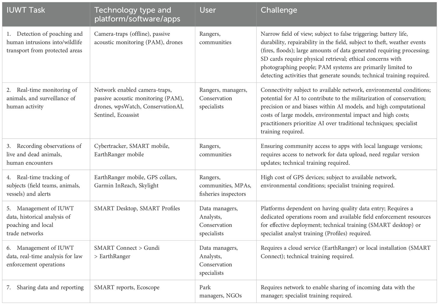
Table 1. IUWT management tasks and conservation technology applications.
2.1 Open-source platforms
Two platforms specifically designed for documenting, analyzing and reporting on poaching and unsustainable wildlife harvest have wide global use at the present time: The Spatial Monitoring and Reporting Tool (SMART) and EarthRanger.
SMART is an open source platform developed through a partnership of 8 conservation NGOs: Frankfurt Zoological Society (FZS), North Carolina Zoo, Panthera, Rewild, Wildlife Conservation Society (WCS), Wildlife Protection Solutions (WPS), World Wildlife Fund (WWF), Zoological Society of London (ZSL), that was designed to enhance management effectiveness and combat threats like IUWT across protected and conserved areas globally (Cronin et al., 2021a). It was created in response to the pressing need to equip rangers and managers with a set of tools to standardize the collection, analysis and reporting of field patrol, antipoaching and wildlife data (Cronin et al., 2021a).
EarthRanger is an open-source web application developed by the Allen Institute for AI (Ai2) a non-profit research institute headquartered in Seattle. EarthRanger is designed to provide a comprehensive solution for ecological monitoring and wildlife management (Wall et al., 2024). It was created in response to the Great Elephant Census that showed a 29% drop in elephant populations across Africa in 7 years (Chase et al., 2016).
SMART and EarthRanger are collectively deployed across >1,500 sites globally with an increasing number of these sites using both platforms. These platforms can be effectively applied to manage poaching and unsustainable wildlife harvest through several key functionalities.
2.1.1 Data aggregation, visualization and analysis
Data from a range of sources, including reports of poaching incidents, trap and snare locations, carcass encounters, community reports of suspect human activity, and live wildlife sightings can be simply collected in the field, compiled and visualized in a single platform. SMART Reports and Ecoscope, an add-on tool for EarthRanger, enable managers to analyze spatial and temporal patterns and identify hotspots of illegal activities, helping to inform targeted anti-poaching strategies and resource allocation. Profiles, an add-on tool for SMART, additionally enables network analysis to calculate relationships between entities involved in local wildlife crime networks.
SMART provides a robust framework to efficiently capture and manage data from a range of sources related to wildlife monitoring, patrolling activities, and illegal activities within protected areas. EarthRanger complements SMART by offering real-time data visualization and advanced asset management tools. Particularly, EarthRanger’s capacity to aggregate diverse data sources, including SMART patrol observations, those from tracked subjects and devices and environmental sensors, ensures that conservation managers have a comprehensive view of their operational landscape. This integration allows for better coordination of patrols and resource deployment, helping rangers anticipate and mitigate threats effectively.
2.1.2 Enhanced patrol efficiency
Detecting and removing traps and snares can impose high financial burden on park protection programs (Tilker et al., 2024). SMART and EarthRanger can help optimize patrol routes and schedules based on data about poaching threats and wildlife movements.
Collaboration across jurisdictions - SMART and EarthRanger facilitate coordination among multiple organizations and agencies involved in wildlife protection. Additionally, data can be pushed or pulled between EarthRanger deployment sites and shared among SMART sites. By sharing data and insights, stakeholders can work together more effectively to combat illegal wildlife trade across park boundaries, jurisdictions, even different regions.
2.1.3 Community engagement
The platforms can support community-based conservation efforts by providing local communities with tools, such as SMART Collect (a community-focused feature of SMART Mobile) and EarthRanger Mobile, to report illegal activities and engage in monitoring efforts. Empowering communities to participate in conservation can help reduce illegal wildlife trade by fostering stewardship and awareness.
Long-term data storage, analysis and dissemination - SMART’s long-term data archiving capabilities allow for the analysis of and reporting on trends over time, which can be crucial for understanding the dynamics of IUWT and the effectiveness of conservation interventions. These historical data can inform future strategies and policies aimed at combating wildlife trafficking. Data may be disseminated using Ecoscope providing highly configurable visualizations and representations of data (Wall et al., 2024).
2.1.4 Real-time monitoring
EarthRanger provides for real-time tracking of wildlife movements and behaviors (Wall et al., 2024). By integrating data from GNSS collars and other tracking devices, conservationists can monitor the locations of endangered species and identify potential poaching threats. Geofencing creates virtual boundaries that trigger automated alerts when animals, particularly those vulnerable to poaching, enter high-risk zones. This early warning system can identify emerging hotspots for human-wildlife conflict and allows for timely interventions when animals are at risk of being targeted for retribution, poaching and illegal trade.
2.1.5 Integrations
Some kinds of data collected in one platform may be visualized in the other. For example, patrol observations collected in SMART may be seen as events on the EarthRanger dashboard (Figure 1). Conversely EarthRanger events can be visualized as independent incidents and patrol waypoints in SMART. This is possible through the creation of Gundi, a tool for use in importing data sources and making them interchangeable in different platforms. Gundi is the result of a collaboration between WCS, WPS and EarthRanger.
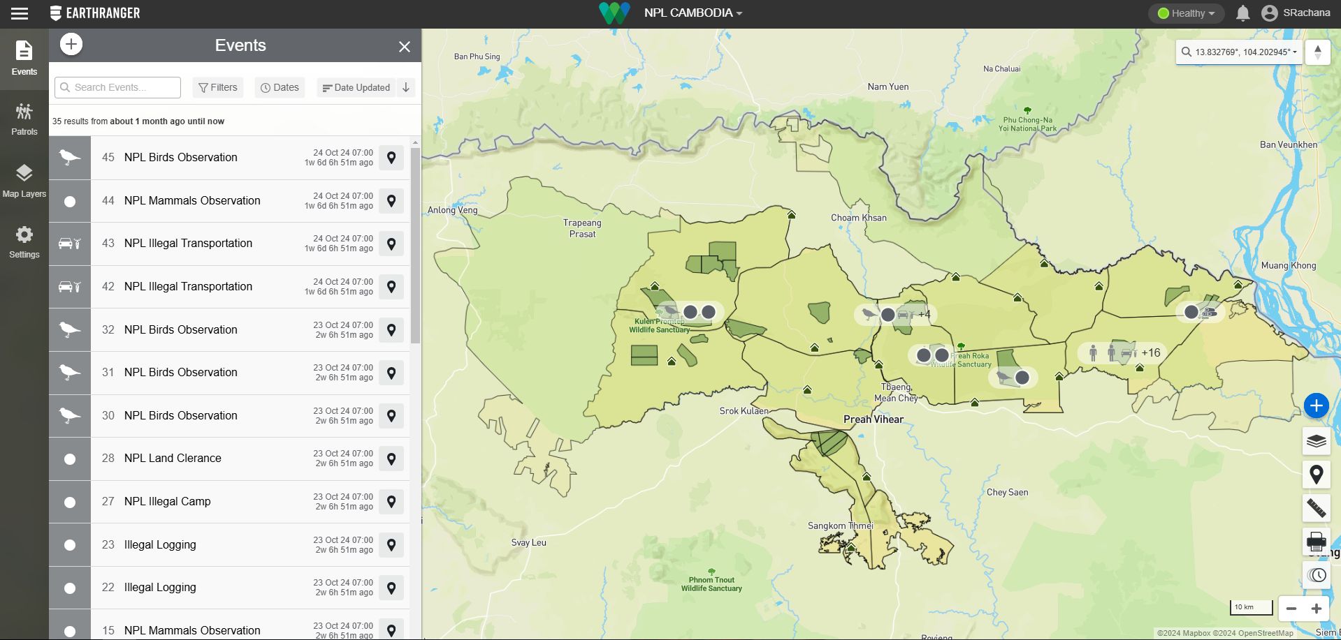
Figure 1. Integration of SMART patrol observations visualized in EarthRanger including illegal wildlife and logging events from Cambodia’s Northern Plains (Wildlife Conservation Society Cambodia).
2.1.6 Add-ons
SMART Profiles is a plug-in to the SMART desktop application which permits the analysis of relationships between entities involved in local poaching and trade networks (vehicles, registrations, houses, licenses, people). It is a standalone, offline tool that can be used to create information on trade networks for guiding law enforcement interventions. For example, using results from 163 interviews of traders involved in trafficking tigers and SMART Profiles Uddin et al. (2023) identified 20 ports used to import and export tigers, highlighting the regional importance of Bangladesh for international tiger trade.
2.1.7 Limitations
The limitations of open-source platforms are first that their usefulness depends on accurate data input from field personnel. Errors in data entry, inconsistent reporting or hardware malfunctions can compromise the quality of the information. Second, a laptop or desktop computer, internet connection and operations room are required. The cost of deploying and maintaining these can be a significant barrier for resource-constrained conservation agencies and organizations. Third, while these tools improve real-time monitoring, eliciting a response to illegal activity is challenging where ranger numbers and field enforcement resources are limited. Fourth, EarthRanger and SMART are primarily designed for site-based monitoring and enforcement and may not adequately address other aspects of illegal wildlife trade (complex networks of traffickers and buyers, online wildlife sale and demand-side drivers of illegal wildlife consumption). Finally, integrating data from diverse sources (e.g. satellite imagery, acoustic monitoring, other sensors) requires an Application Programming Interface (API) and can be complex and time consuming.
Together, SMART and EarthRanger offer an integrated, holistic approach to conservation management that optimizes resources, enhances situational awareness, and supports strategic, data-driven decisions. By leveraging the strengths of both platforms, and by providing timely information and facilitating proactive action, SMART and EarthRanger can play a vital role in enhancing the effectiveness of efforts to combat illegal wildlife trade, ultimately contributing to the protection of threatened species and the preservation of biodiversity.
2.2 Mobile devices and apps
Mobile devices such as rugged smartphones and tablets are adaptable for use in monitoring poaching and illegal transport of wildlife through enhanced navigation, real-time tracking, and improved communication.
GNSS-enabled mobile devices provide accurate navigation in remote areas, crucial for patrolling and navigating protected areas. Ruggedized devices and protective cases ensure durability and multi-day battery life in challenging field conditions.
EarthRanger allows data integration from GNSS tracking devices attached to wildlife or connected camera-traps to monitor real-time movements of live animals (Adams et al., 2017) and identify trafficking routes for poached carcasses. The health and safety of remotely operating field teams can be tracked using Garmin InReach data feeds to the EarthRanger platform.
Open-source apps can be tailored to the specific needs of IUWT monitoring. For example, SMART Mobile (Cronin et al., 2021a) and Cybertracker (Steventon, 2002) enable efficient spatial data collection, including the mapping of significant wildlife observations and recording animal surveys. EarthRanger Mobile additionally provides live tracking and communication by field teams.
EarthRanger mobile and SMART mobile enable rangers and community members to report incidents of poaching, illegal logging and suspicious incidents.
Apps designed for species identification in trade such as Wildlife Witness and Nature Intelligence System (Julia, 2016; Tlusty et al., 2023) provide valuable information for field enforcement officers combating IUWT. WildScan, an app created by FREELAND Foundation, is a digital field guide for identifying protected species and a reporting tool for frontline rangers to document suspected illegal wildlife trade at the point of harvest or initial transport. Furthermore, platforms like iNaturalist, a free, global citizen science platform and social network dedicated to connecting people with nature, EarthRanger Mobile and SMART Collect can empower local communities to contribute to monitoring efforts by recording and transmitting observations of endangered species and suspected illegal activities. Observations recorded in iNaturalist may be visualized in EarthRanger through an integration between the platforms.
2.2.1 Limitations
Communities do not always have access to the tools thus requiring support from NGOs, as well as training, and local language options in the user interface. The apps need updating to ensure compatibility with new hardware. The apps need to respond to evolving needs of the community. If these limitations can be overcome, these tools can help enhance the reach and responsiveness of enforcement efforts.
In summary, mobile devices and apps are indispensable tools in documenting poaching and other threats to wildlife at source sites. Their versatility, affordability, and ease of use empower a wide range of stakeholders, from rangers and researchers to local communities and law enforcement agencies, to contribute to the protection of wildlife and the disruption of illegal trade networks.
2.3 Aerial based technologies
2.3.1 Remote-sensing
Remote sensing technologies are revolutionizing conservation efforts by providing a means to evaluate wildlife habitats and track human-induced changes (Pimm et al., 2015; Marvin et al., 2016). Satellite imagery, aerial surveillance, and open-data platforms like Global Forest Watch (GFW), Fire Information for Resource Management System (FIRMS), and Ororatech offer a “bird’s-eye view” of vast landscapes, enabling real-time monitoring and detection of threats (Tabor and Holland, 2021; Shea, 2022). These technologies have an important role to play in detecting and tracking forest loss and degradation, identifying drivers of deforestation, including the creation of roads which poachers and traders use to access a forest for its wildlife (Clements et al., 2014; Hughes, 2018), supporting rapid response efforts, and monitoring changes in land use and identifying areas at risk of habitat loss. They have potential as tools for verifying targets for Reduced Emissions from Deforestation and forest Degradation (REDD+). Global Forest Watch fire and deforestation (GLAD) alerts can easily be configured for any area and may be visualized in the standalone platform or as an integrated data source in EarthRanger via Gundi (a platform for integrating external data sources).
2.3.1.1 Limitations
Even high-resolution satellite imagery may not be able to detect small-scale activities such as poaching, especially in dense vegetation. It can be difficult to differentiate between legitimate human activities (e.g., farming, logging) and illegal poaching activities. The presence of vehicles or trails does not necessarily indicate poaching. There are temporal limitations as for example, satellite imagery provides snapshots in time. Poaching can occur between image captures, making it difficult to detect in real-time. Cloud cover and other weather conditions can also limit the availability of usable imagery. Remote sensing can detect the “where” but not always the “why.” Understanding the complex behavioral patterns of poachers requires on-the-ground intelligence. Many poaching activities occur at night, when visual satellite imagery is ineffective. While thermal imaging can help, it also has limitations in terms of resolution and coverage.
Remote sensing technologies are powerful tools for conservation, but they must be used in conjunction with other methods, such as: on-the-ground patrols, intelligence gathering, community engagement, and law enforcement, the use of technologies such as camera traps, and acoustic monitoring (see below). By combining these approaches, we can create a more comprehensive and effective strategy for combating poaching and the illegal wildlife trade.
2.3.2 Drones
Due to the vast areas that require monitoring for conservation, unmanned aircraft systems (UAS) also known as conservation drones have become a relatively common tool for conservationists as they can rapidly cover relatively large areas (several square kilometers) in one flight to collect data on animal locations, poaching or logging, and can carry several different sensors for such data collection.
Generally their usage focuses on three aspects of wildlife conservation (Chabot and Bird, 2015; Wich and Koh, 2018). First, mapping and monitoring land cover to determine the extent of various land cover types and changes such as deforestation or degradation in those. Second, to determine the distribution and abundance of animal species (Corcoran et al., 2021). Third, to detect the presence of poaching or other activities that might impact animal species or the habitat they occur in such as fires. Obtaining data on animal distribution and abundance can give valuable insights into whether populations are stable or not which can be linked to hunting or capture for wildlife trade if there are signs of people (Hambrecht et al., 2019; Doull et al., 2021) or their activities (e.g. fires) in drone images.
The most commonly used drones for the three use cases are multirotor and fixed wing types that are pre-programmed to carry out flights along a set of waypoints or are flown manually by the pilot (Wich and Koh, 2018).
For land cover mapping drones with a visual spectrum camera by itself or in combination with a multispectral camera, and less commonly a hyperspectral sensor would be used (Chabot and Bird, 2015; Wich and Koh, 2018). Due to the high resolution of the images collected from drones small deforestation can be readily detected. To detect animals a visual spectrum camera on its own or in combination with a thermal infrared camera have been used for a wide variety of animal species from small birds to large marine mammals (Chabot and Bird, 2015; Wich and Koh, 2018). In addition drones equipped with very high frequency (VHF) antennas or other systems to localize collars or tags on animals have been used (Desrochers et al., 2018). Detection of humans has largely been done with thermal infrared cameras (Hambrecht et al., 2019; Doull et al., 2021) as well as for the detection of fires even though visual spectrum cameras have been used as well to detect the smoke.
An example of drones’ application in biodiversity is a study that addressed the challenge of counting animals in spatially aggregated populations using drone-derived orthomosaics, focusing on the mass nesting of the endangered Giant Amazon River Turtles (Podocnemis expanasa) on a river separating Bolivia from Brazil. By developing a method that enhances the accuracy of surveys during mass nesting events, researchers aimed to provide more reliable data for conservation efforts.
The study used a novel approach combining drones and tagging of individuals led by the University of Florida and Wildlife Conservation Society, together with a capture-recapture model to address the difficulties involved in counting turtle nesting aggregations. This allowed variations in daily counts to be highlighted and corrections for errors encountered to be incorporated. This comprehensive approach improves the accuracy of wildlife population estimation using drones and can serve as an example for other ecological studies and conservation efforts. But also, together with local communities, drones are planned to monitor the illegal harvesting of eggs once the turtles have finished nesting, making this tool essential for different purposes. The advances highlight the importance and impact of use of drones in conservation, envisioning the future role of technology in research, and emphasizing the critical need for accuracy in data collection for monitoring animal populations.
2.3.2.1 Limitations
There are, however, still challenges for drone usage. A major challenge is the regulatory framework that often only allows flights within visual line of sight (e.g. < 500 m in many countries) unless detailed safety cases are developed for the civil aviation authorities. In areas with low risk to people, property and animals some more flexibility would facilitate the usage of drones. Limited flight duration is often seen as a constraint as well but flight durations have been increasing and given the civil aviation authorities’ regulations increased flight duration might not always lead to increased operational options. Drones generate large amounts of data for which manual inspecting by human analysts is often slow and costly. The need for machine learning to be further integrated for near-real time or slower analyses is paramount to increase drone survey efficiency.
2.4 Ground-deployed technologies
2.4.1 Acoustic sensors
Conservation bioacoustics, the study of sounds for understanding, managing, restoring, and protecting species and ecosystems (Rice et al., 2023), is a rapidly growing field with significant potential in wildlife crime prevention. A central tool within this field is Passive Acoustic Monitoring (PAM), enabled by autonomous recording units (ARUs). These devices capture environmental soundscapes, including biological, geophysical and anthropogenic sounds. ARUs have become increasingly accessible due to advancements in technology and reductions in cost (Hill et al., 2019), allowing for broader spatial and temporal monitoring (Lahoz-Monfort and Magrath, 2021). ARUs can be deployed in remote, vast areas non-invasively, with high temporal resolution, including nighttime monitoring. Depending on conservation and research goals, the devices can be configured to record continuously or at scheduled intervals. A limitation is that high frequency recordings for bats for example drains batteries fast and quickly fills up SD cards requiring ARUs to be checked more frequently.
PAM systems generate massive datasets, capturing sounds from a wide variety of species across multiple ecosystems, such as birds, bats, cetaceans and other mammals, fish, and amphibians (Darras et al., 2024), as well as from human activities such as logging and firearm-based hunting (Astaras et al., 2017; Prince et al., 2019; Dobbins et al., 2020; Sethi et al., 2020; Wrege et al., 2024). These datasets offer valuable insights, but handling their large volume poses challenges. The integration of artificial intelligence (AI) into acoustic monitoring is addressing this issue. Advances in AI, particularly in deep learning techniques have significantly improved the capabilities of automated recognition systems (Stowell, 2022). These technologies enable the detection of gunshots and chainsaw sounds, which can indicate illegal poaching and logging activities (Liu et al., 2019; Katsis et al., 2022).
PAM provides an efficient way to monitor gun hunting pressure across large areas with high spatial and temporal resolution (Astaras et al., 2017, Astaras et al., 2020; Wrege et al., 2017; Katsis et al., 2022). In such applications, a grid of semi-autonomous sensors is deployed across a landscape to record the soundscape over extended periods. In some regions, even mobile smartphones have proven effective for recording gunshots, offering a more accessible alternative to ARUs for practitioners (Vu et al., 2024). The recorded data is later analyzed to identify events of interest.
Dobbins et al. (2020) demonstrated the effectiveness of PAM by comparing it to camera traps for monitoring gunshot hunting activity in a tropical ecosystem. Acoustic sensors detected hunting events significantly more frequently than camera traps, which have a limited field of view (120° and 5-meter range). In contrast, ARUs can detect sounds from all directions and at estimated distances of up to about 1.2 km (Prince et al., 2019; Astaras et al., 2020, Astaras et al., 2023; Dobbins et al., 2020; Pardo et al., 2022), giving them a considerable advantage for detecting poaching events and conducting studies across large areas.
PAM systems are a valuable tool for adaptive management strategies in areas prone to poaching and illegal deforestation (Astaras et al., 2017, Astaras et al., 2020; Wrege et al., 2017; Katsis et al., 2022; Pardo et al., 2022; Vu et al., 2024; Yoh et al., 2024). These systems provide robust long-term datasets that help conservation managers assess the effectiveness of current strategies and refine future plans. This approach enables the identification of temporal trends and spatial hotspots of illegal activities, which can inform more efficient allocation of resources for patrolling and monitoring. For instance, the international NGO Panthera has used acoustical monitoring systems to support their anti-poaching patrols in Guatemala and Honduras. Their acoustic monitoring project enabled patrols to focus on specific areas and times when illegal activity is most likely, improving the effectiveness of their interventions (Alberts, 2021). While quantitative data on the overall improvement in patrol effectiveness is not available, Panthera has observed that the acoustic data provides actionable insights. For example, acoustic monitoring revealed that poaching activity tends to increase on dark nights when the moon is not out, as evidenced by an increase in shotgun sounds. This information allows patrols to adapt their schedules and focus efforts during high-risk times.
Rainforest Connection’s Guardian system exemplified how, in some cases, PAM can be used for both adaptive management and real-time interventions (Hatcher, 2021). The Guardian devices, powered by solar panels and equipped with AI and machine learning, use mobile networks or satellite connectivity to monitor forest soundscapes and transmit audio data in real time to the Rainforest Connection (RFCx) guardian cloud platform. When connected via mobile networks, the devices continuously send recordings for immediate analysis, detecting suspicious sounds like chainsaws or trucks. With satellite connectivity, on-board analysis detects these sounds and sends immediate alerts to rangers in the field. The initial version of the system, which used repurposed smartphones, successfully detected illegal logging in real time in Sumatra, allowing authorities to intervene and stop the activity (Gross, 2014). The system has since been expanded to regions in Africa, Latin America, and Southeast Asia. Audiomoth is another low-cost acoustic monitoring device that records ambient sounds, enabling the detection of gunshots, snares, or animal distress calls indicative of poaching events.
Although real-time monitoring in remote environments is still in its infancy (Vu et al., 2024), it represents a critical area for future development, as it could significantly improve the timeliness of patrol interventions. As AI continues to evolve, the possibility of automating this real-time response becomes more feasible (Sethi et al., 2020). However, several challenges must be overcome to realize the full potential of these technologies. One of the primary limitations is bandwidth, particularly in remote areas where connectivity is limited, which hinders real-time data transmission (Vu et al., 2024). Moreover, the accuracy of AI-driven systems in identifying sounds associated with poaching activities needs further refinement to reduce false positives (Wrege et al., 2017; Katsis et al., 2022; Vu et al., 2024). Unsupervised deep learning, a promising alternative that needs further research, can detect anomalous sounds like gunshots and chainsaws by identifying deviations from typical patterns in the soundscape (Sethi et al., 2020).
Another promising technology still in development is Wireless Anti-Poaching for Elephants and Rhinos (WIPER), a collaboration between researchers from Vanderbilt University and Colorado State University (Kalmár et al., 2019, Wittemyer G., personal communication, October 2024). WIPER detects gunshots by capturing the ballistic shockwave generated by a bullet from up to 50 meters away. Integrated into existing GPS tracking collars, WIPER is expected to send real-time alerts to authorities with the precise location of the shot. Although the system doesn’t prevent poaching, it could provide vital evidence for law enforcement and potentially enable rangers to intercept poachers. Other technologies aimed at localizing sound from illegal activities are also in development but have not yet been fully implemented for conservation purposes. One such example is the Time Difference Of Arrival (TDOA) sound localization platform, which uses low-cost Raspberry Pi units synchronized via GPS to pinpoint sounds from different sources (Hendrikse, 2023). Though still evolving, these innovations represent the growing potential for real-time responses in conservation efforts.
In the marine environment, PAM systems have been employed to detect illegal blast fishing (Braulik et al., 2017; Melo-Souza et al., 2024), a destructive practice that devastated both marine life and habitats (Slade and Kalangahe, 2015). Acoustic monitoring allows for the identification of the distinct shockwave signature from underwater explosions, easily distinguished from other sounds (Woodman et al., 2003). In Tanzania, acoustic monitoring provided a spatial assessment of blast fishing intensity along the entire coastline. This study detected 281 blasts, revealing hotspots of illegal activity, primarily near reefs and in shallow coastal waters. The acoustic data enabled conservation managers to pinpoint areas where enforcement should be focused for maximum impact. Additionally, the monitoring identified the times of day when blasting was most frequent, providing valuable information for targeted enforcement operations (Braulik et al., 2017).
PAM and acoustic animal tracking (AT) have proven valuable for detecting illegal fishing (Salloum et al., 2018; Tickler et al., 2019; Villegas-Ríos et al., 2020; Alós et al., 2022). PAM can detect vessel activities in restricted areas by capturing their acoustic signatures, including motorized vessels that cannot be detected by satellite monitoring. This can help authorities to redirect compliance and surveillance efforts more effectively (Kline et al., 2020). AT is increasingly used to collect spatial data on marine species (Matley et al., 2022) using acoustic tags that emit ID-coded signals detected by arrays or gates of acoustic receivers (Heupel et al., 2006). According to Villegas-Ríos et al. (2020), specific detection patterns can indicate fishing mortality. A study conducted in the British Indian Ocean Territory found that a sudden spike in the loss of acoustic tags from multiple reef sharks was strongly correlated with the presence of illegal fishing vessels (Tickler et al., 2019). This “fishing signature” in the telemetry data highlighted how acoustic monitoring could help detect illegal activities in real or near real-time, providing crucial evidence for enforcement. However, for effective detection of illegal activities using AT, the area intended to be protected must be monitored via a dense receiver array that has overlapping detection ranges, and the target species must exhibit high site fidelity or home range within the monitored area (Tickler et al., 2019; Villegas-Ríos et al., 2020).
2.4.1.1 Limitations
Not all forms of hunting can be detected with PAM. PAM systems are primarily limited to detecting activities that generate sounds, such as gunshots, chainsaws, vessel noise indicative of illegal fishing. Silent hunting methods, such as trapping, snaring, or poisoning, are less likely to be detected, highlighting the need for a combination of complementary technologies to monitor a broader range of threats effectively.
2.4.2 Camera traps
Camera traps have long been used for monitoring wildlife populations (Burton et al., 2015) including species critically threatened by IUWT (Khwaja et al., 2019; Petersen et al., 2020). More recently camera traps have become recognized for their potential to support anti-poaching efforts (Cress and Zommers, 2014; Moore et al., 2021). Remotely triggered cameras, strategically placed in wildlife corridors and hotspots accessed by humans, detect both animals and human activity, offering valuable insights into temporal and spatial patterns of animal movement as well as illegal activities such as poaching, logging, and encroachment.
Camera traps offer several advantages as security devices: 1) they provide objective observations of illegal activities including georeferenced images of both animals and human activity with time and date stamps, thus supporting law enforcement efforts with unbiased evidence that may be admissible in court, 2) they can remotely monitor inaccessible areas, reducing the need for costly ground patrols, 3) technological advancements have made camera traps more affordable, efficient and accessible (Wearn and Glover-Kapfer, 2019).
Several recent studies demonstrate the effectiveness of camera traps in detecting and deterring wildlife crime. Illegal human activity associated with tiger and tiger prey in the Bangladesh Sundarban flooded forest was quantified by setting camera-traps at entrances to creeks accessible to small boats (Hossain et al., 2016). Using camera-traps to detect human incursions, poaching activity in parks in Brazil was predicted to occur in places with concentrations of game species abundance, near water resources near roads and forest edges (Ferreguetti et al., 2018; de Matos Dias et al., 2020).
2.4.2.1 Limitations
The limitations of camera-traps for detecting poaching and other security threats are first, that camera traps capture images within a relatively narrow field of view. This means they may miss activities that occur outside of their range. Deploying enough cameras to cover vast landscapes or complex habitats can be logistically challenging and expensive. Second, cameras can be triggered by non-target objects, such as vegetation movement, small animals, or even changes in light. This can result in a large number of false positives, requiring significant time and effort to review and classify images. Conversely, if the trigger sensitivity is too low, the camera may miss important events. Third, camera traps generate massive amounts of data, particularly when deployed in high-traffic areas. Reviewing and analyzing these images can be time-consuming and labor-intensive. Managing and storing large image datasets requires robust data management systems. Fourth, camera traps are vulnerable to theft or damage by poachers, wildlife, or environmental factors. Concealing cameras effectively can be challenging, and their presence may be detected by those engaging in illegal activities. Fifth, while camera traps can capture images of humans, identifying individuals can be difficult, especially if they are wearing masks or other disguises. Identifying specific wildlife individuals can also be challenging, particularly for species with subtle variations. Sixth, battery life and memory card capacity can limit the duration of continuous monitoring. Gaps in monitoring can occur when batteries need to be replaced or memory cards need to be retrieved. Extreme weather conditions, such as heavy rain, snow, or fog, can affect camera performance. Dense vegetation or challenging terrain can limit camera placement and effectiveness. Seventh, while some systems have the capability to issue real-time alerts, many budget-friendly camera trap systems require physical retrieval of the data stored on internal SD cards. This means that poaching can occur, and not be known about for days, or weeks. Finally, the use of camera traps raises ethical concerns regarding privacy, particularly when deployed in areas frequented by humans (Sharma et al., 2020). It is important to ensure that camera trap deployments are conducted in a responsible and ethical manner, respecting the privacy of individuals and communities.
By complementing camera trap data with data from acoustic sensors (Dobbins et al., 2020), and AI-powered surveillance systems (see below), conservationists can further enhance their ability to detect, analyze, and respond to wildlife crime. This integrated approach empowers rangers, communities and managers with objective information, enabling more effective and targeted interventions to protect endangered species and their habitats.
2.4.3 AI-powered surveillance systems
Artificial intelligence (AI) has emerged as a tool with great potential for conservation including for applications related to combating IUWT (Reynolds et al., 2024). By leveraging machine learning, computer vision, and real-time data processing, either in the field or in the cloud, these systems can open the door to rapid detection and response of dangerous events and potential poaching activities across vast, remote landscapes where traditional surveillance methods might fall short.
Wildlife Protection Solutions (WPS) has developed wpsWatch, a free-for-conservation, hardware agnostic web platform to help protected area managers fight wildlife crime and promote human-wildlife coexistence. wpsWatch uses AI to analyze imagery from more than 3,500 connected camera traps and other surveillance systems globally. Users are provided with secure alerts via SMS, WhatsApp, email, and dashboards, and data also flows to protected area management tools such as SMART, EarthRanger, Cmore (a field data collection platform used by South African National Parks), and others via Gundi. wpsWatch enables conservationists to maximize real-time knowledge of conserved areas by identifying potential threats including humans and vehicle intrusions in real-time. Such detections allow conservation practitioners to rapidly develop “pattern of life” awareness as well as respond to emerging threats immediately.
wpsWatch improves management efficiency by ensuring that field staff receive instant notifications based on rules specified in the platform’s alerting engine. In addition, a complete record of all imagery is maintained for awareness of other details such as non-target species observations, fire detection, environmental changes, and other “bycatch” intelligence. wpsWatch also automatically activates remotely deployed lights, alarms, audio equipment, scent dispensers, and other electric wildlife deterrent devices to prevent human-wildlife conflict. Finally, the platform monitors and reports the overall health of the network to ensure that all deployed technology is functioning properly. For operations that do not have 24-hour monitoring capacity WPS also offers an optional program wherein certified volunteers remotely assist by reviewing anonymized camera feeds for additional assistance.
This technology, when paired with strong field presence and well-defined operational procedures contributes to an integrated approach combining real-time awareness with on-the-ground action. Such systems enhance a protected area’s capacity to effectively combat poaching and IUWT (Figure 2), monitor wildlife health (Figure 3) and safeguard endangered species.
Figure 2. Poachers who were eventually apprehended due to alerts from wpsWatch. Credit Wildlife Protection Solutions.

Figure 3. An image of a leopard caught in a snare, prompting a veterinary response. Credit Wildlife Protection Solutions.
ConservationAI is an online platform that detects and classifies animals, humans, and poaching-related objects using visual spectrum and thermal infrared cameras (Fergus et al., 2024). The platform can process historical camera trap image and video data as well as data from cameras that are either connected to WIFI or a mobile phone network. The latter provides users with the option to get near-real time detections emailed to them within approximately 30 seconds or so after the camera trap has been triggered. It thus provides a system for rapid interventions if needed. ConservationAI also offers a desktop application that allows users to run the models on their own computers without uploading the data to the online platform. ConservationAI has a number of regional multi-species camera trap models that are regularly updated and expanded with new species. The platform also has several drone models for optical and thermal data and aims to expand drone models (Chalmers et al., 2021).
AddaxAI is an offline tool that uses the open-source MegaDetector model as well as other regional models to analyze and classify images from camera-traps on a local computer.
Conservation X Labs’ Sentinel team has been building a device to plug into regular camera traps to turn them smarter with AI capabilities and communications. These units filter all images taken on the cameras, highlighting species, people, and events of particular interest, and send this information back to users over cellular, satellite networks, or LoRa. LoRa is physical proprietary radio communication technique, designed for long-range, low-power communication, particularly for IoT applications. The devices are designed to be robust for field use and act as the first data filtering step, as information is processed before it ever leaves the field, cutting down significantly on the time it takes to retrieve SD cards, manually sort recorded photos, and respond to field events (Figure 4).
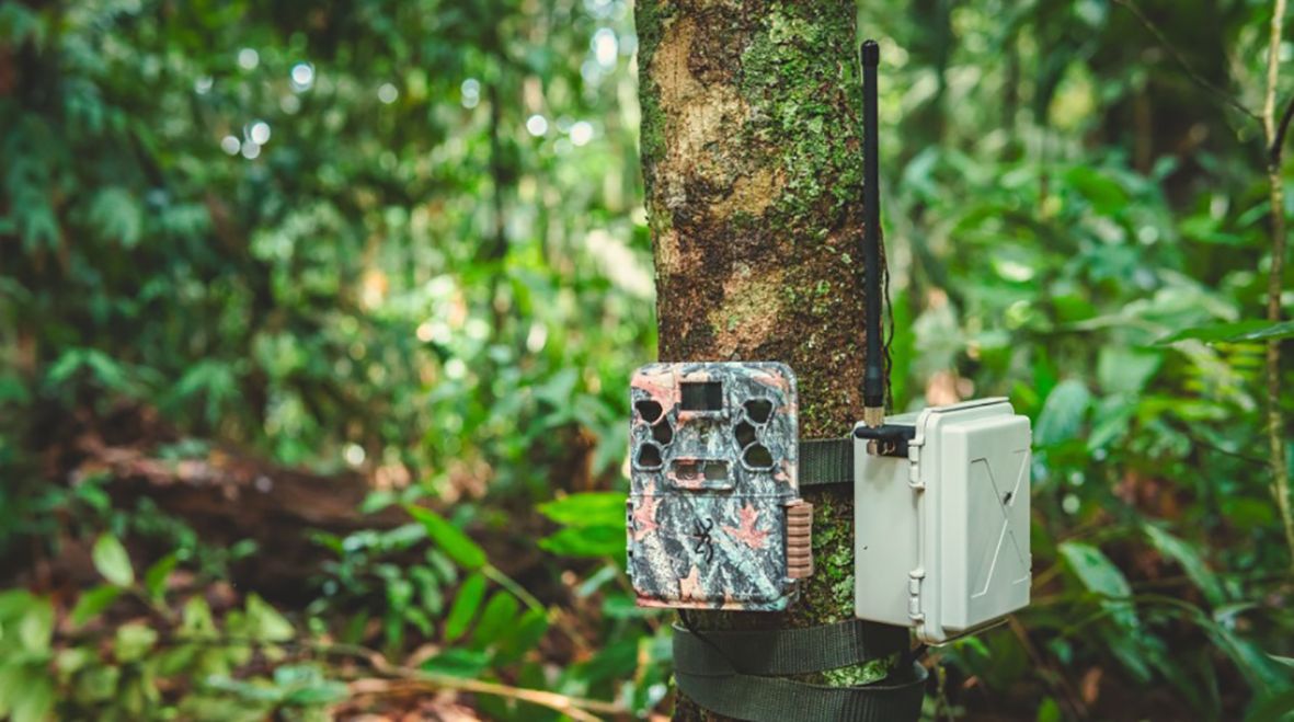
Figure 4. A Sentinel device connected to a Browning trail camera in Peru. Credit. Conservation X Labs.
Trailguard AI is a camera-based alert system powered by artificial intelligence. It is designed to identify specific wildlife species, humans, and vehicles, instantly sending real-time image alerts via GSM, long-range radio, or satellite networks.
Skylight extends the use of AI to support efforts to tackle illegal fishing and other threats to marine biodiversity. Developed by Ai2, the no-cost and real-time maritime monitoring and analysis software empowers the visualization and analysis of vessel behaviors. Using publicly available satellite data offered by NASA, the European Space Agency (ESA), and others, along with data from the Automatic Identification System (AIS), the software provides its users with AI-powered vessel detections (Beukema et al., 2023) and insights based on specific behaviors, such as at-sea transshipment of goods, a key challenge to transparency in the fight against illegal fishing and IWT.
Skylight’s AI has the ability to monitor activities in the most isolated areas (see also 3.2 below). Skylight’s AI processes data globally at scale, handling approximately 100 million AIS messages as well as nearly two terabytes of satellite imagery daily. By analyzing this volume of information, Skylight can detect over 290,000 vessels per week across all of its public satellite data sources, revealing patterns and uncovering vessels potentially evading detection. This is crucial, given maritime transport is a popular way to smuggle illegal wildlife products.
With its AI-driven intelligence, Skylight flags suspicious behaviors in real-time such as unauthorized entry into protected areas, sudden changes in a vessel’s speed, or covert transshipments with non-AIS transmitting vessels. These alerts enable authorities to investigate potential IWT activity on the open sea, helping to intercept smuggled wildlife products from entering the black market.
By design, AI-powered surveillance systems should generate and send alerts in real-time as events occur and send that information to the relevant authorities. These systems are not made to replace human capacity to identify threats, but ensure analysts are made aware of potential threats as soon as possible, and ultimately decide if a response is required. AI-powered surveillance systems can help law enforcement and local communities, who struggle to get information from remote field locations in the first place, have reliable and faster access to that information, so that response times can be minimized.
Beyond providing these data through Skylight’s web platform, Ai2 has open sourced the models and makes the data available via API for other systems to integrate the data, helping extend the value of Skylight to reach more enforcement, parks and fisheries agencies in more than 75 countries.
Integrating these AI tools with existing platforms like EarthRanger provides teams with comprehensive data on poaching patterns from an array of input sensors, allowing for predictive analytics to preempt future poaching incidents.
2.4.3.1 Limitations
The increasing integration of AI in conservation holds great promise but also presents some risks that need careful consideration. One major concern is the potential for AI to contribute to the militarization of conservation, with automated systems triggering enforcement without understanding local contexts, potentially leading to conflict. Biases within AI models, “AI pollution,” and the high computational costs of large models pose further challenges (Reynolds et al., 2024). Moreover, the environmental impact of AI infrastructure’s energy consumption must be addressed. The dual-use nature of AI tools means they could be exploited by malicious actors, such as poachers or wildlife traders, for harmful purposes. There is potential for AI to exacerbate existing inequalities. If AI-driven conservation becomes the dominant approach, funding and resources may shift towards wealthy institutions capable of implementing it, leaving traditional, field-based conservation efforts underfunded. This could undermine the diversity of voices and knowledge in conservation, particularly those of local communities and indigenous populations. Furthermore, there’s a risk of losing essential conservation skills as practitioners prioritize AI over traditional techniques. Maintaining expertise in species, ecosystems, and communities is crucial for creating reliable AI and ensuring that AI-driven recommendations are grounded in reality. The reliance on data, raises concerns about “AI colonialism,” where data extracted from the Global South is used to train models in the Global North, leading to externally imposed management decisions (Reynolds et al., 2024). This could perpetuate colonial legacies and disregard local rights and knowledge.
To mitigate these risks, it’s crucial to adopt ethical guidelines, integrate diverse perspectives, ensure equitable access to resources, and prioritize human-in-the-loop designs and democratic decision-making.
3 Case studies
In this section we present two case studies; one terrestrial and one marine that illustrate the nature of complex sets of threats from IUWT that impact wildlife, requiring the design of context specific solutions to support conservation teams with appropriate conservation technology tools.
3.1 Ensuring patrol effectiveness across the Greater Kafue Ecosystem with SMART and EarthRanger
Kafue National Park (22,400 km²), Africa’s third-largest unfenced park, sits within Zambia’s Greater Kafue Ecosystem (GKE) of 66,000 km², which includes nine Game Management Areas. The GKE’s diverse landscapes—ranging from the Busanga plains to expansive Miombo woodlands—host Zambia’s largest cheetah population, over 200 lions, and 21 antelope species. However, wildlife here has suffered from intense poaching and habitat loss, severely impacting predator-prey dynamics, especially for large herbivores and big cats.
In 2018, Zambia’s Department of National Parks and Wildlife (DNPW) joined forces with conservation groups, including Game Rangers International, Musekese Conservation, Panthera, Wildlife Crime Prevention, and Mushingashi (joined by African Parks in 2021), to coordinate conservation activities in the GKE with a strong focus on Kafue NP. This coalition brought increased funding and resources, bolstering efforts across the landscape.
At the heart of this conservation initiative are the SMART and EarthRanger platforms, which together strengthen patrol management and conservation monitoring across the Greater Kafue Ecosystem (GKE) (Figure 5) (UNEP-WCMC and IUCN, 2021). In the GKE, SMART was used to standardize the collection and visualization of patrol data, monitor routes, and track sightings, offering park managers transparent insights into antipoaching effectiveness. By mid-2022, SMART had aggregated data from all 49 patrol teams across 11 hubs and six different organizations in the GKE. This data informed monthly coordination meetings, enabling adaptive management and boosting patrol productivity (Figure 6).
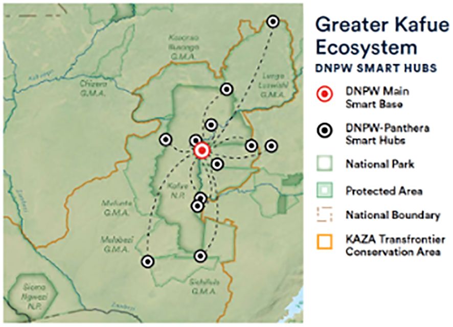
Figure 5. Map of the Greater Kafue Ecosystem in Zambia showing the Department of National Parks and Wildlife (DNPW) Smart Hubs network including main Smart Base, Smart Hubs, Kafue National Park and other protected areas within the KAZA Transfrontier Conservation Area.
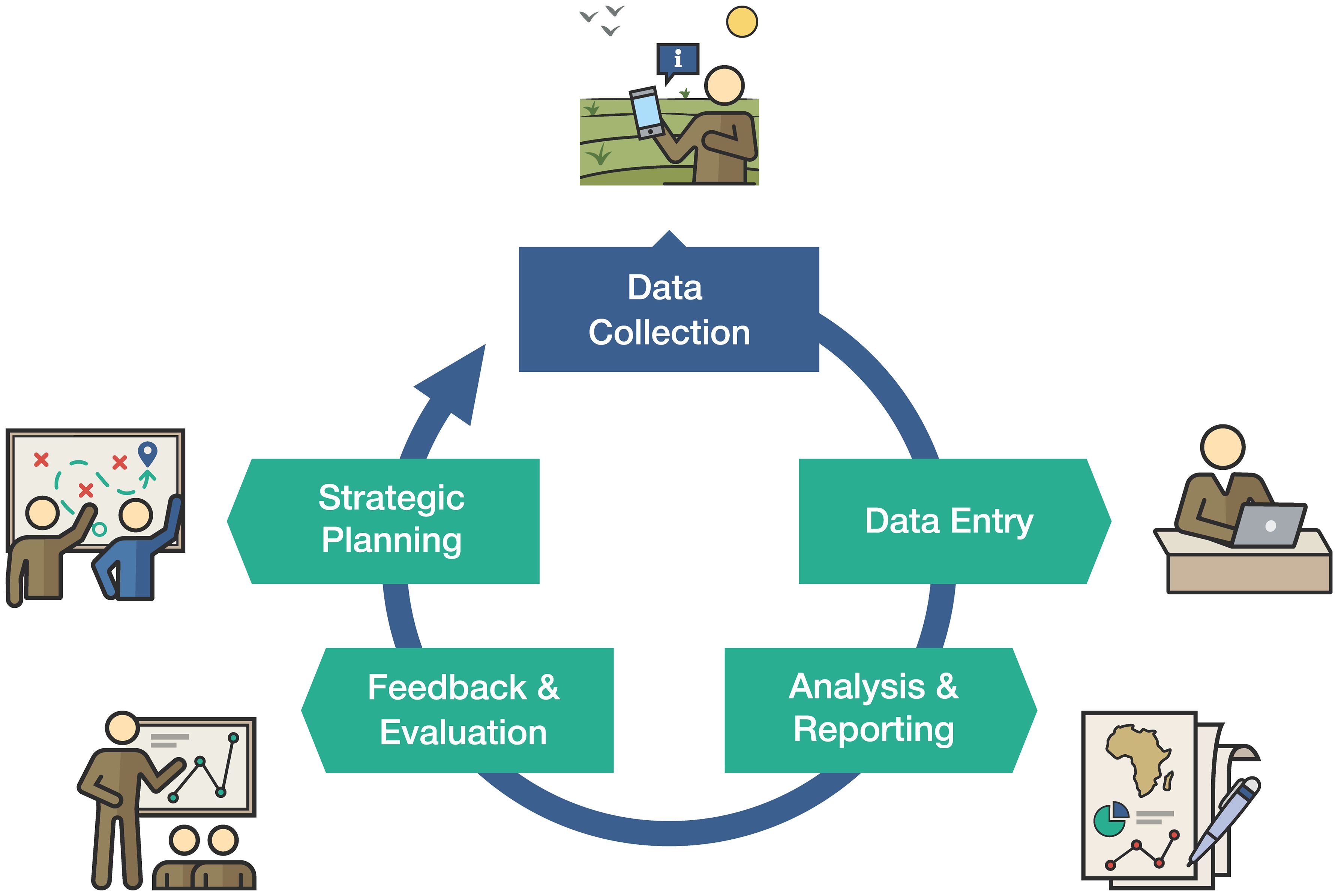
Figure 6. Infographic explaining the SMART adaptive management cycle used by DNPW and Panthera for adaptive patrol operations. The cycle includes five stages: Data Collection which includes Pre-briefing and De-briefing, Data Entry, Analysis & Reporting, Feedback & Evaluation, and Strategic Patrol Planning. The cycle begins when patrol teams are briefed on the day of deployment and given relevant targets to meet during their patrol duty. Patrol teams collect and record data on threats and wildlife. Patrol teams report on their patrol activities and data is vetted and entered in the SMART database. Data is processed into highly visual tables, charts and maps, showing patrol effort and encounters in spatial context. Reports are created showing patrol efforts and results. Patrol objectives and targets are created and evaluated using SMART data. Finally plans are created using the updated data and information reports.
In 2021 alone, patrol teams covered 211,073 km and made 322 apprehensions through diverse methods, from foot patrols to aerial surveillance. SMART’s design, especially with SMART Mobile, enables each organization to retain control of its own data while contributing to a unified, ecosystem-wide database. This shared resource facilitates a landscape-wide adaptive management approach, enhancing collaboration among organizations to optimize conservation efforts across the Greater Kafue Ecosystem.
Complementing SMART, EarthRanger was implemented in 2021 to provide real-time monitoring of assets such as vehicles, patrol teams, and collared wildlife. This platform integrates data from patrols and wildlife monitoring, enabling what’s known as the “Halo approach” to specifically protect wild cats in real-time. EarthRanger’s centralized display allows law enforcement teams from different organizations to coordinate seamlessly, boosting situational awareness and resource efficiency across Kafue NP. Together, SMART and EarthRanger underpin a collaborative approach that strengthens patrolling effectiveness, allowing DNPW and partners to respond adaptively to the ever-evolving challenges within the GKE.
3.2 Protecting the Conkouati-Douli marine protected area with EarthRanger and Skylight
Conkouati-Douli National Park (PNCD) in the Republic of Congo is located along the Atlantic coastline. It encompasses marine and terrestrial habitats, making it the second-largest protected area in the country. The Park covers 7,995 km², of which 4,275 km² is designated for marine protection, which makes up 12% of the country’s Exclusive Economic Zone (EEZ). The PNCD borders the Mayumba MPA in Gabon, forming the Mayumba-Conkouati Transfrontier Marine Protected Area, which aims to protect shared marine resources and valuable habitats for biodiversity resilience. Despite cooperative efforts to create the Transfrontier MPA, illegal, unreported and unregulated (IUU) fishing remains a persistent threat, particularly from industrial demersal trawlers and the growing artisanal fishing fleet that targets key species like sharks (Figure 7). IUU fishing undermines conservation and protection efforts within the PNCD and the larger Mayumba-Conkouati Transfrontier MPA, highlighting an urgent need for strengthened surveillance initiatives, cost-effective compliance measures and enhanced enforcement strategies.
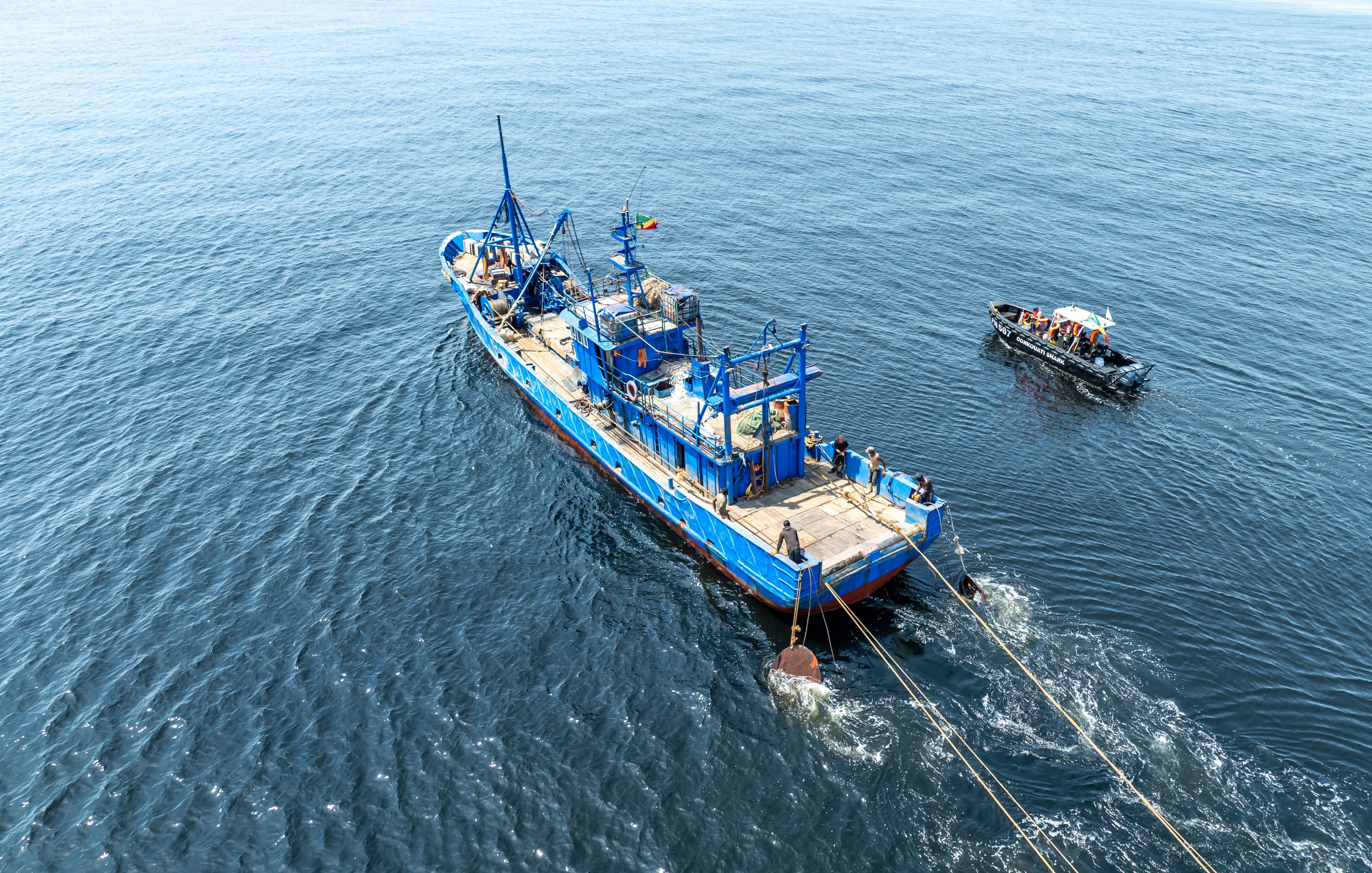
Figure 7. Patrol vessel (black) approaching illegal fishing vessel (blue) inside the Conkouati-Douli National Park. Credit PNCD.
In 2023, NGO Noé, the management partner of the PNCD, acquired a high-tech nine-meter patrol vessel to aid in marine compliance operations. However, detecting IUU fishing remained a significant challenge. This was due to inconsistent reports from local fishers, limited ability to differentiate between commercial and fishing vessels from a distance, and the park’s remote location, which makes direct monitoring from the PNCD headquarters difficult. As a result, compliance efforts have primarily relied on visible policing rather than intelligence-driven missions. To improve IUU vessel detection and marine compliance mission effectiveness, Noé started using Skylight, a maritime monitoring and analysis tool using satellite data and AI algorithms to determine vessel activity from the Allen Institute for AI (Ai2), integrated with EarthRanger.
Skylight utilizes the Sentinel satellite array and Night Lights (VIIRS) data to provide weekly data on vessel presence and activity within a specified area. This data is analyzed to generate a threat assessment with precise geospatial references to the borders of the PNCD. The analysis includes filtering to identify “dark vessel” detections (vessels not actively transmitting their Automatic Identification System (AIS) signals). These dark vessels are flagged as potential targets for IUU fishing. Based on data clusters, specific zones within the PNCD are prioritized for compliance missions, maximizing the likelihood of successful intervention by focusing on high-risk zones. Integrating Skylight data with EarthRanger allows alerts of vessels entering the PNCD to be generated using a geofence setup in Skylight. For example, Figure 8 shows four vessels registered in different countries (China, Spain, United Kingdom and the Netherlands) detected by Skylight entering the PNCD. These alert notifications allow for near real-time data to advise operational requirements. Skylight technology has significantly improved the ability to detect vessels and analyze data related to IUU fishing activities within the PNCD.
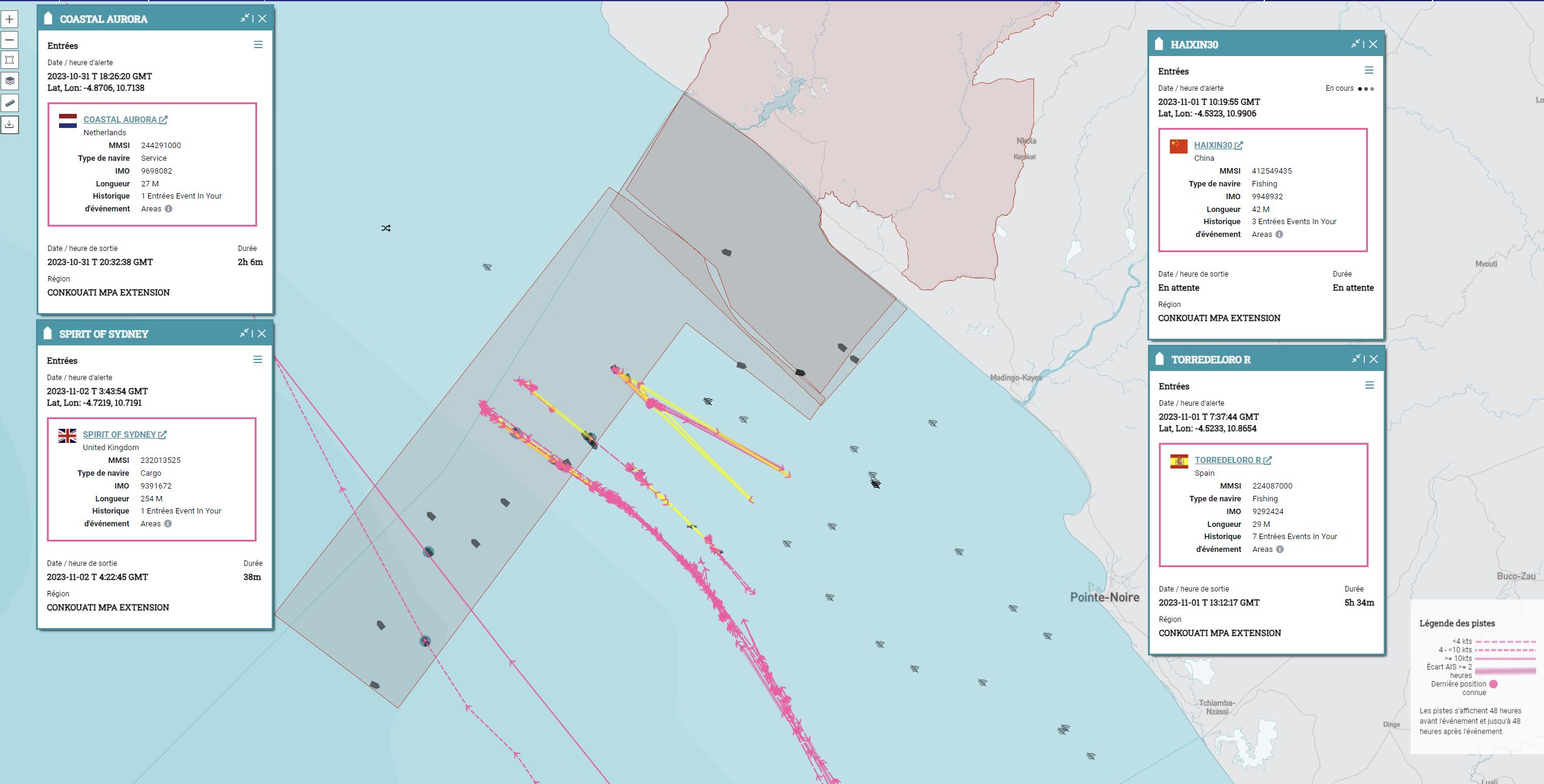
Figure 8. Visualization of marine traffic off the coast of the Republic of the Congo using Skylight showing tracklogs of detected vessels actively fishing inside the Conkouati Marine Protected Area Extension (pink and yellow lines of HAIXIN30 and TORREDOLORO operating closer to the mainland) compared with tracklogs of commercial vessels passing through (pink lines of COASTAL AURORA and SPIRIT OF SYDNEY operating further from mainland).
The implementation of EarthRanger’s unified platform for real-time monitoring, tracking, and communication has markedly enhanced operational safety, streamlined the systematic recording of intervention data through the EarthRanger mobile application, and improved the recording of marine observations during patrols. Over an eight month period, using an integrated combination of EarthRanger’s core functionalities with Skylight’s AI capabilities and real-time satellite data analysis, the PNCD marine program conducted 40 sea-going missions, of which Skylight data-informed 18. In total, 111 vessels were detected at sea, of which 60 were intercepted. Of the 60 intercepted vessels, 55 were artisanal pirogues, and five were industrial fishing trawlers. Analyzing Skylight data, an additional nine industrial vessels were prevented from crossing into the PNCD due to visible patrols based on vessel grouping detections in high-risk zones. In addition, Skylight identified two dark vessels in the PNCD, prompting a compliance mission; the vessels were Congolese-flagged semi-industrial shark fishing gillnetters operated by foreign captains.
The integration of Skylight and EarthRanger has improved all operational aspects of the PNCD marine program. By developing standard operating procedures based on these management tools, the PNCD has enhanced mission safety and communication (Figure 9). This integration has also led to better detection capabilities, quicker compliance response times, and strengthened data and evidence collection. By streamlining and strengthening Monitoring, Control, and Surveillance (MCS) tools, the PNCD has created an effective marine compliance strategy that is flexible to changes in threats imposed by IUU fishing activity.
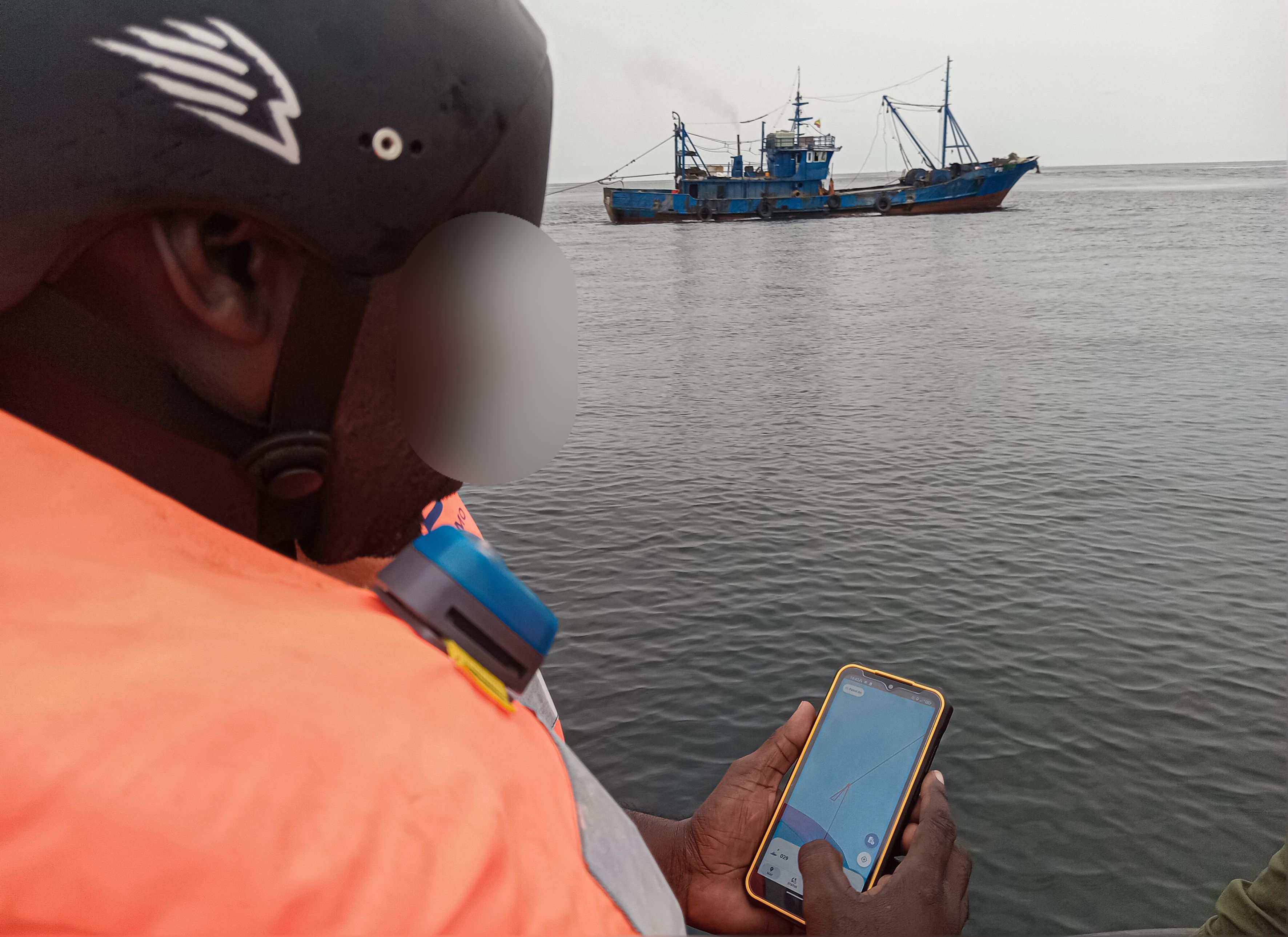
Figure 9. An observer uses EarthRanger mobile to record an illegal fishing vessel. Credit PNCD.
4 Discussion
Illegal and unsustainable wildlife trade is a complex and multifaceted threat that is constantly changing with market-specific demand for wildlife species and products and as availability fluctuates due to changes in law enforcement effort and effectiveness across the trade chain, and as species populations increase or decrease across their ranges. As evidenced from the case studies presented here, conservation operations aimed at protecting fish stocks, or wildlife in source populations from entering the trade chain need to be carefully tailored to address local and regionally specific threats, utilize the best available local and scientific knowledge of wildlife behavior and distribution, and be flexible to adapt to changing conditions. The evolution of conservation technology has produced powerful support tools in containing these threats with some important caveats;
1. What the technology can and cannot do needs to be clearly understood by the user or it will not be used effectively;
2. Ensure the right technology is in the hands of the right people;
3. Focus technology development on supporting rangers, managers and other practitioners involved in IUWT work;
4. Build technology competence and capacity;
5. Foster community building and create opportunities around technology;
6. Engage the technology sector to innovate and design technology to support IUWT work;
7. Technology adoption should be encouraged as a complement to antipoaching and IUWT investigation skills rather than as a replacement.
How these challenges may be addressed is described in detail by (Cronin et al., 2021b). Future improvements to the platforms and technologies described in this report could include the following;
1. Using enhanced AI and machine learning by incorporating predictive analytics to forecast poaching hotspots and trafficking routes (Xu et al., 2019). Automating data analysis to identify patterns and anomalies that may indicate illegal activity.
2. Improved sensor networks by expanding the use of acoustic sensors and camera-traps to provide continuous monitoring of wildlife populations and potential threats. Developing more durable and energy-efficient sensors for long-term deployment in remote areas.
3. Application of blockchain technology to track the legal trade of wildlife products, making it easier to identify and intercept illegal shipments.
4. Developing tools for automated monitoring of social media platforms for the sale and trade of illegal wildlife products. Using social media analytics to understand consumer demand and identify key markets.
5. Developing systems that facilitate seamless data sharing and strengthen collaboration between law enforcement agencies in different countries.
6. Employing demand reduction strategies by integrating data that can help to understand and counteract the motivations for poaching and illegal trade. This could include indicators derived from poaching encounters, social science data and economic data.
By harnessing the power of data, connectivity, and innovation, conservation technology can empower those on the front lines (rangers, communities, managers, conservation specialists) to protect wildlife, disrupt poaching networks, and safeguard habitats for species that are subject to unsustainable levels of harvest and trade (Speaker et al., 2022; Fergus et al., 2023). We have shown here the transformative potential of technology in combating the poaching and unsustainable harvest components of illegal wildlife trade, offering a roadmap for a more effective and sustainable future for wildlife conservation.
Data availability statement
The original contributions presented in the study are included in the article/supplementary material. Further inquiries can be directed to the corresponding author.
Author contributions
AL: Conceptualization, Investigation, Methodology, Project administration, Supervision, Writing – original draft, Writing – review & editing. DC: Conceptualization, Writing – review & editing. SW: Methodology, Writing – original draft. JS: Writing – original draft. AH: Writing – review & editing. MM: Writing – original draft. OT: Writing – original draft. VR: Writing – original draft, Writing – review & editing. KS: Writing – review & editing. XS: Writing – original draft. ES: Writing – original draft. HC: Writing – original draft. NK: Writing – review & editing.
Funding
The author(s) declare that no financial support was received for the research and/or publication of this article.
Acknowledgments
The authors acknowledge the support of their institutions that facilitated the contributions of the authors. VR additionally acknowledges support from WILDLABS for her contribution.
Conflict of interest
AL, JS, AH, NK, DC, SW, OT, VR, KS, XS, ES, HC are employed by non-governmental organizations that have created or co-created software and applications mentioned in this report.
The remaining author declares that the research was conducted in the absence of any commercial or financial relationships that could be construed as a potential conflict of interest.
SW declared that they were an editorial board member of Frontiers, at the time of submission. This had no impact on the peer review process and the final decision.
Generative AI statement
The author(s) declare that no Generative AI was used in the creation of this manuscript.
Publisher’s note
All claims expressed in this article are solely those of the authors and do not necessarily represent those of their affiliated organizations, or those of the publisher, the editors and the reviewers. Any product that may be evaluated in this article, or claim that may be made by its manufacturer, is not guaranteed or endorsed by the publisher.
References
Adams T. S. F., Chase M. J., Rogers T. L., and Leggett K. E. A. (2017). Taking the elephant out of the room and into the corridor: can urban corridors work? Oryx 51, 347–353. doi: 10.1017/S0030605315001246
Ahlers N., Creecy J., Frankham G., Johnson R. N., Kotze A., Linacre A., et al. (2017). ‘ForCyt’ DNA database of wildlife species. Forensic Sci. Int. Genet. Suppl. Ser. 6, e466–e468. doi: 10.1016/j.fsigss.2017.09.195
Alberts E. C. (2021). Electronic ears listen to poachers in a key Central American jaguar habitat. Mongabay.2021
Alós J., Aarestrup K., Abecasis D., Afonso P., Alonso-Fernandez A., Aspillaga E., et al. (2022). Toward a decade of ocean science for sustainable development through acoustic animal tracking. Glob. Change Biol. 28, 5630–5653. doi: 10.1111/gcb.16343
Astaras C., Linder J. M., Wrege P., Orume R., Johnson P. J., and Macdonald D. W. (2020). Boots on the ground: the role of passive acoustic monitoring in evaluating anti-poaching patrols. Environ. Conserv. 47, 213–216. doi: 10.1017/S0376892920000193
Astaras C., Linder J. M., Wrege P., Orume R. D., and Macdonald D. W. (2017). Passive acoustic monitoring as a law enforcement tool for Afrotropical rainforests. Front. Ecol. Environ. 15, 233–234. doi: 10.1002/fee.1495
Astaras C., Sideri-Manoka Z.-A., Vougioukalou M., Migli D., Vasiliadis I., Sidiropoulos S., et al. (2023). Acoustic Monitoring Confirms Significant Poaching Pressure of European Turtle Doves (Streptopelia turtur) during Spring Migration across the Ionian Islands, Greece. Animals 13 (4), 687. doi: 10.3390/ani13040687
Belecky M. and Gray T. N. E. (2020). Silence of the snares: southeast asia’s snaring crisis (Gland, Switzerland: WWF International).
Beukema P., Bastani F., Wolters P., Herzog H., and Ferdinando J. (2023). Satellite imagery and AI: A new era in ocean conservation, from research to deployment and impact. arxiv.doi: 10.48550/arXiv.2312.03207
Braulik G., Wittich A., Macaulay J., Kasuga M., Gordon J., Davenport T. R. B., et al. (2017). Acoustic monitoring to document the spatial distribution and hotspots of blast fishing in Tanzania. Mar. Pollut. Bull. 125, 360–366. doi: 10.1016/j.marpolbul.2017.09.036
Burton A. C., Neilson E., Moreira D., Ladle A., Steenweg R., Fisher J. T., et al. (2015). REVIEW: Wildlife camera trapping: a review and recommendations for linking surveys to ecological processes. J. Appl. Ecol. 52, 675–685. doi: 10.1111/1365-2664.12432
Chabot D. and Bird D. M. (2015). Wildlife research and management methods in the 21st century: Where do unmanned aircraft fit in? J. Unmanned Veh. Syst. 3, 137–155. doi: 10.1139/juvs-2015-0021
Chalmers C., Fergus P., Aday C., Montanez C., Longmore S. N., and Wich S. E. (2021). Video analysis for the detection of animals using convolutional neural networks and consumer-grade drones. J. Unmanned Veh. Syst. 9, 112–127. doi: 10.1139/juvs-2020-0018
Chase M. J., Schlossberg S., Griffin C. R., Bouché P. J. C., Djene S. W., Elkan P. W., et al. (2016). Continent-wide survey reveals massive decline in African savannah elephants. PeerJ 4, e2354. doi: 10.7717/peerj.2354
Clements G. R., Lynam A. J., Gaveau D., Yap W. L., Lhota S., Goosem M., et al. (2014). Where and how are roads endangering mammals in southeast asia’s forests? PloS One 9, e115376. doi: 10.1371/journal.pone.0115376
Corcoran E., Winsen M., Sudholz A., and Hamilton G. (2021). Automated detection of wildlife using drones: Synthesis, opportunities and constraints. Methods Ecol. Evol. 12, 1103–1114. doi: 10.1111/2041-210X.13581
Cress D. and Zommers Z. (2014). Emerging Technologies: Smarter ways to fight wildlife crime. Environ. Dev. 12, 62–72. doi: 10.1016/j.envdev.2014.07.002
Cronin D. T., Benbow S., Bergl R. A., Bourgault L., Caro L., Dancer A., et al. (2021b). Empowering rangers through technology and innovation. Parks Steward. Forum 37, 196–205. doi: 10.5070/P537151750
Cronin D. T., Dancer A., Long B., Lynam A. J., Muntifering J., Palmer J., et al. (2021a). “Application of SMART software for conservation area management,” in Conservation technology. Eds. Wich S. A. and Piel A. K. (Oxford, UK: Oxford University Press). doi: 10.1093/oso/9780198850243.003.0010
Darras K. F., Rountree R., Van Wilgenburg S., Cord A. F., Chen Y., Dong L., et al. (2024). Worldwide Soundscapes: a synthesis of passive acoustic monitoring across realms. bioRxiv 2024, 4.10.588860. doi: 10.1101/2024.04.10.588860
de Matos Dias D., Ferreguetti Á.C., and Rodrigues F. H. G. (2020). Using an occupancy approach to identify poaching hotspots in protected areas in a seasonally dry tropical forest. Biol. Conserv. 251, 108796. doi: 10.1016/j.biocon.2020.108796
Desrochers A., Tremblay J. A., Aubry Y., Chabot D., Pace P., and Bird D. M. (2018). Estimating wildlife tag location errors from a VHF receiver mounted on a drone. Drones 2 (4), 44. doi: 10.3390/drones2040044
Dobbins M., Sollmann R., Menke S., Almeyda Zambrano A., and Broadbent E. (2020). An integrated approach to measure hunting intensity and assess its impacts on mammal populations. J. Appl. Ecol. 57, 2100–2111. doi: 10.1111/1365-2664.13750
Doull K. E., Chalmers C., Fergus P., Longmore S., Piel A. K., and Wich S. A. (2021). An evaluation of the factors affecting ‘Poacher’ Detection with drones and the efficacy of machine-learning for detection. Sensors 21 (12), 4074. doi: 10.3390/s21124074
Duffy R., St John F. A. V., Büscher B., and Brockington D. (2016). Toward a new understanding of the links between poverty and illegal wildlife hunting. Conserv. Biol. 30, 14–22. doi: 10.1111/cobi.12622
Fergus P., Chalmers C., Longmore S., and Wich S. (2024). Harnessing artificial intelligence for wildlife conservation. arxiv.doi: 10.48550/arXiv.2409.10523
Fergus P., Chalmers C., Longmore S., Wich S., Warmenhove C., Swart J., et al. (2023). Empowering wildlife guardians: an equitabl e digital stewardship and reward system for biodiversity conservation using deep learning and 3/4G camera traps. Remote Sens. 15 (11), 2730. doi: 10.3390/rs15112730
Ferreguetti Á.C., Pereira-Ribeiro J., Prevedello J. A., Tomás W. M., Rocha C. F. D., and Bergallo H. G. (2018). One step ahead to predict potential poaching hotspots: Modeling occupancy and detectability of poachers in a neotropical rainforest. Biol. Conserv. 227, 133–140. doi: 10.1016/j.biocon.2018.09.009
Fukushima C. S., Tricorache P., Toomes A., Stringham O. C., Rivera-Téllez E., Ripple W. J., et al. (2021). Challenges and perspectives on tackling illegal or unsustainable wildlife trade. Biol. Conserv. 263, 109342. doi: 10.1016/j.biocon.2021.109342
Gross M. (2014). Connecting with the natural world. Curr. Biol. 24, R629–R632. doi: 10.1016/j.cub.2014.07.005
Hahn N. R., Bombaci S. P., and Wittemyer G. (2022). Identifying conservation technology needs, barriers, and opportunities. Sci. Rep. 12, 4802. doi: 10.1038/s41598-022-08330-w
Hambrecht L., Brown R. P., Piel A. K., and Wich S. A. (2019). Detecting ‘poachers’ with drones: Factors influencing the probability of detection with TIR and RGB imaging in miombo woodlands, Tanzania. Biol. Conserv. 233, 109–117. doi: 10.1016/j.biocon.2019.02.017
Hatcher T. (2021). Rainforest connection: protecting Indonesia’s forests through threat response. Huaweiblog 27.
Heupel M. R., Semmens J. M., and Hobday A. J. (2006). Automated acoustic tracking of aquatic animals: scales, design and deployment of listening station arrays. Mar. Freshw. Res. 57, 1–13. doi: 10.1071/MF05091
Hill A. P., Prince P., Snaddon J. L., Doncaster C. P., and Rogers A. (2019). AudioMoth: A low-cost acoustic device for monitoring biodiversity and the environment. HardwareX 6, e00073. doi: 10.1016/j.ohx.2019.e00073
Hossain A. N. M., Barlow A., Barlow C. G., Lynam A. J., Chakma S., and Savini T. (2016). Assessing the efficacy of camera trapping as a tool for increasing detection rates of wildlife crime in tropical protected areas. Biol. Conserv. 201, 314–319. doi: 10.1016/j.biocon.2016.07.023
Hughes A. C. (2018). Have Indo-Malaysian forests reached the end of the road? Biol. Conserv. 223, 129–137. doi: 10.1016/j.biocon.2018.04.029
Julia J. (2016). Empowering smartphone users to bear witness to illegal wildlife trade. Mongabay.Available at: https://news.mongabay.com/2016/05/empowering-smartphone-users-bear-witness-illegal-wildlife-trade/ (Accessed May 26, 2016).
Kalmár G., Wittemyer G., Völgyesi P., Rasmussen H. B., Maróti M., and Lédeczi Á. (2019). Animal-borne anti-poaching system. Proc. 17th Annu. Int. Conf. Mob. Syst. Appl. Serv. 91–102. doi: 10.1145/3307334.3326080
Kamminga J., Ayele E., Meratnia N., and Havinga P. (2018). Poaching detection technologies—A survey. Sensors 18 (5), 1474. doi: 10.3390/s18051474
Katsis L. K. D., Hill A. P., Piña-Covarrubias E., Prince P., Rogers A., Patrick Doncaster C., et al. (2022). Automated detection of gunshots in tropical forests using convolutional neural networks. Ecol. Indic. 141, 109128. doi: 10.1016/j.ecolind.2022.109128
Khwaja H., Buchan C., Wearn O. R., Bahaa-el-din L., Bantlin D., Bernard H., et al. (2019). Pangolins in global camera trap data: Implications for ecological monitoring. Glob. Ecol. Conserv. 20, e00769. doi: 10.1016/j.gecco.2019.e00769
Kline L. R., DeAngelis A. I., McBride C., Rodgers G. G., Rowell T. J., Smith J., et al. (2020). Sleuthing with sound: Understanding vessel activity in marine protected areas using passive acoustic monitoring. Mar. Policy 120, 104138. doi: 10.1016/j.marpol.2020.104138
Lahoz-Monfort J. J. and Magrath M. J. L. (2021). A comprehensive overview of technologies for species and habitat monitoring and conservation. BioScience 71, 1038–1062. doi: 10.1093/biosci/biab073
Lemieux A. M., Pickles R. S. A., and Weekers D. (2022). “Problem analysis for wildlife protection in 55 steps,” in Center for problem-oriented policing,: center for problem-oriented policing. Ed. Phoenix A. Z. :. (Phoenix, USA: Arizona State University).
Liu Y., Cheng Z., Liu J., Yassin B., Nan Z., and Luo J. (2019). AI for Earth: Rainforest conservation by acoustic surveillance. arxiv.doi: 10.48550/arXiv.1908.07517
Marvin D. C., Koh L. P., Lynam A. J., Wich S., Davies A. B., Krishnamurthy R., et al. (2016). Integrating technologies for scalable ecology and conservation. Glob. Ecol. Conserv. 7, 262–275. doi: 10.1016/j.gecco.2016.07.002
Matley J. K., Klinard N. V., Barbosa Martins A. P., Aarestrup K., Aspillaga E., Cooke S. J., et al. (2022). Global trends in aquatic animal tracking with acoustic telemetry. Trends Ecol. Evol. 37, 79–94. doi: 10.1016/j.tree.2021.09.001
Melo-Souza V., Gavrilov A., and Rossi-Santos M. R. (2024). Dropping a bombshell: Acoustic characterization of blast fishing in Todos os Santos Bay, Brazil, and its implication for marine conservation. Mar. Pollut. Bull. 202, 116332. doi: 10.1016/j.marpolbul.2024.116332
Moore J. F., Uzabaho E., Musana A., Uwingeli P., Hines J. E., and Nichols J. D. (2021). What is the effect of poaching activity on wildlife species? Ecol. Appl. 31, e02397. doi: 10.1002/eap.2397
Moreto W. D. (2015). Introducing intelligence-led conservation: bridging crime and conservation science. Crime Sci. 4, 15. doi: 10.1186/s40163-015-0030-9
Pardo J. M., Cruz P., Moya S., Pizzio E., Foletto F., Robino F., et al. (2022). Predicting poaching hotspots in the largest remnant of the Atlantic Forest by combining passive acoustic monitoring and occupancy models. Biol. Conserv. 272, 109600. doi: 10.1016/j.biocon.2022.109600
Petersen W. J., Savini T., and Ngoprasert D. (2020). Strongholds under siege: Range-wide deforestation and poaching threaten mainland clouded leopards (Neofelis nebulosa). Glob. Ecol. Conserv. 24, e01354. doi: 10.1016/j.gecco.2020.e01354
Pimm S. L., Alibhai S., Bergl R., Dehgan A., Giri C., Jewell Z., et al. (2015). Emerging technologies to conserve biodiversity. Trends Ecol. Evol. 30, 685–696. doi: 10.1016/j.tree.2015.08.008
Prince P., Hill A., Piña Covarrubias E., Doncaster P., Snaddon J. L., and Rogers A. (2019). Deploying acoustic detection algorithms on low-cost, open-source acoustic sensors for environmental monitoring. Sensors 19 (3), 553. doi: 10.3390/s19030553
Reynolds S. A., Beery S., Burgess N., Burgman M., Butchart S. H. M., Cooke S. J., et al. (2024). The potential for AI to revolutionize conservation: a horizon scan. Trends Ecol. Evol. 40, 191–207. doi: 10.1016/j.tree.2024.11.013
Rice A. N., García M. L., Symes L. B., and Holger K. (2023). Conservation bioacoustics: listening to the heartbeat of the earth. Acoust. Today 19 (3), 46–53. doi: 10.1121/AT.2023.19.3.46
Salloum H., Sutin A., and Pollara A. (2018). Detecting illegal fishing activity with acoustic technology: Passive acoustic methods help USCG fight illegal fishing. Coast Guard J. Saf. Secur. Sea Proc. Mar. Saf. Secur. Counc. 75, 40–44.
Sethi S. S., Jones N. S., Fulcher B. D., Picinali L., Clink D. J., Klinck H., et al. (2020). Characterizing soundscapes across diverse ecosystems using a universal acoustic feature set. Proc. Natl. Acad. Sci. 117, 17049–17055. doi: 10.1073/pnas.2004702117
Sharma K., Fiechter M., George T., Young J., Alexander J. A., Bijoor A., et al. (2020). Conservation and people: Towards an ethical code of conduct for the use of camera traps in wildlife research. Ecol. Solut Evid. 1, e12033. doi: 10.1002/2688-8319.12033
Shea K. (2022). “Measuring the impact of monitoring: how we know transparent near-real-time data can help save the forests,” in Transformational change for people and the planet: evaluating environment and development. Eds. Uitto J. I. and Batra G. (Springer International Publishing, Cham), 263–273. doi: 10.1007/978-3-030-78853-7_18
Slade L. M. and Kalangahe B. (2015). Dynamite fishing in Tanzania. Mar. Pollut. Bull. 101, 491–496. doi: 10.1016/j.marpolbul.2015.08.025
Speaker T., O’Donnell S., Wittemyer G., Bruyere B., Loucks C., Dancer A., et al. (2022). A global community-sourced assessment of the state of conservation technology. Conserv. Biol. 36, e13871. doi: 10.1111/cobi.13871
Stowell D. (2022). Computational bioacoustics with deep learning: a review and roadmap. PeerJ 10, e13152. doi: 10.7717/peerj.13152
Stringham O. C., Toomes A., Kanishka A. M., Mitchell L., Heinrich S., Ross J. V., et al. (2021). A guide to using the internet to monitor and quantify the wildlife trade. Conserv. Biol. 35, 1130–1139. doi: 10.1111/cobi.13675
Tabor K. M. and Holland M. B. (2021). Opportunities for improving conservation early warning and alert systems. Remote Sens. Ecol. Conserv. 7, 7–17. doi: 10.1002/rse2.163
Thomas-Walters L., Veríssimo D., Gadsby E., Roberts D., and Smith R. J. (2020). Taking a more nuanced look at behavior change for demand reduction in the illegal wildlife trade. Conserv. Sci. Pract. 2, e248. doi: 10.1111/csp2.248
Tickler D. M., Carlisle A. B., Chapple T. K., Curnick D. J., Dale J. J., Schallert R. J., et al. (2019). Potential detection of illegal fishing by passive acoustic telemetry. Anim. Biotelemetry 7, 1. doi: 10.1186/s40317-019-0163-9
Tilker A., Niedballa J., Viet H. L., Abrams J. F., Marescot L., Wilkinson N., et al. (2024). Addressing the Southeast Asian snaring crisis: Impact of 11 years of snare removal in a biodiversity hotspot. Conserv. Lett. 17, e13021. doi: 10.1111/conl.13021
Tlusty M. F., Cawthorn D.-M., Goodman O. L. B., Rhyne A. L., and Roberts D. L. (2023). Real-time automated species level detection of trade document systems to reduce illegal wildlife trade and improve data quality. Biol. Conserv. 281, 110022. doi: 10.1016/j.biocon.2023.110022
UNEP-WCMC and IUCN (2021). Protected Planet The World Database on Protected Areas (WDPA Online) October 2021, Cambridge UK, UNEP-WCMC and IUCN. Available at: https://www.protectedplanet.net WDPA_Oct2021_Public.
Uddin N., Enoch S., Harihar A., Pickles R. S. A., and Hughes A. C. (2023). Tigers at a crossroads: Shedding light on the role of Bangladesh in the illegal trade of this iconic big cat. Conserv. Sci. Pract. 5, e12952. doi: 10.1111/csp2.12952
Villegas-Ríos D., Freitas C., Moland E., Thorbjørnsen S. H., and Olsen E. M. (2020). Inferring individual fate from aquatic acoustic telemetry data. Methods Ecol. Evol. 11, 1186–1198. doi: 10.1111/2041-210X.13446
Vu T. T., Phan D. V., Le T. S., and Clink D. J. (2024). Investigating hunting in a protected area in Southeast Asia using passive acoustic monitoring with mobile smartphones and deep learning. Ecol. Indic. 167, 112501. doi: 10.1016/j.ecolind.2024.112501
Wall J., Lefcourt J., Jones C., Doehring C., O’Neill D., Schneider D., et al. (2024). EarthRanger: An open-source platform for ecosystem monitoring, research and management. Methods Ecol. Evol. 15 (11), 1968–1979. doi: 10.1111/2041-210x.14399
Wearn O. R. and Glover-Kapfer P. (2019). Snap happy: camera traps are an effective sampling tool when compared with alternative methods. R. Soc Open Sci. 6, 181748. doi: 10.1098/rsos.181748
Woodman G. H., Wilson S. C., Li V. Y. F., and Renneberg R. (2003). Acoustic characteristics of fish bombing: potential to develop an automated blast detector. Mar. Pollut. Bull. 46, 99–106. doi: 10.1016/S0025-326X(02)00322-3
Wrege P. H., Bambi F. B.-D., Malonga P. J. F., Samba O. J., and Brncic T. (2024). Early detection of human impacts using acoustic monitoring: An example with forest elephants. PloS One 19, e0306932. doi: 10.1371/journal.pone.0306932
Wrege P. H., Rowland E. D., Keen S., and Shiu Y. (2017). Acoustic monitoring for conservation in tropical forests: examples from forest elephants. Methods Ecol. Evol. 8, 1292–1301. doi: 10.1111/2041-210X.12730
Xu L., Gholami S., Mc Carthy S., Dilkina B., Plumptre A., Tambe M., et al. (2019). Stay ahead of poachers: illegal wildlife poaching prediction and patrol planning under uncertainty with field test evaluations. arXiv, 1903.06669. doi: 10.48550/arXiv.1903.06669
Keywords: conservation technology, poaching, artificial intelligence, open-source software, camera-traps, remote sensing, drones, acoustic sensors
Citation: Lynam AJ, Cronin DT, Wich SA, Steward J, Howe A, Kolla N, Markovina M, Torrico O, Reyes V, Sophalrachana K, Stevens X, Schmidt E and Cox H (2025) The rising tide of conservation technology: empowering the fight against poaching and unsustainable wildlife harvest. Front. Ecol. Evol. 13:1527976. doi: 10.3389/fevo.2025.1527976
Received: 14 November 2024; Accepted: 07 April 2025;
Published: 27 May 2025.
Edited by:
Astrid Andersson, The University of Hong Kong, Hong Kong SAR, ChinaReviewed by:
Kim Feddema, Edith Cowan University, AustraliaJordi Janssen, Utrecht University, Netherlands
Copyright © 2025 Lynam, Cronin, Wich, Steward, Howe, Kolla, Markovina, Torrico, Reyes, Sophalrachana, Stevens, Schmidt and Cox. This is an open-access article distributed under the terms of the Creative Commons Attribution License (CC BY). The use, distribution or reproduction in other forums is permitted, provided the original author(s) and the copyright owner(s) are credited and that the original publication in this journal is cited, in accordance with accepted academic practice. No use, distribution or reproduction is permitted which does not comply with these terms.
*Correspondence: Antony John Lynam, dG9ueWxAZWFydGhyYW5nZXIuY29t