 Jiashuang Hou1†
 Binglin Liu
- 1School of Economics and Management, Nanning Normal University, Nanning, China
- 2School of Geography and Planning, Nanning Normal University, Nanning, China
- 3Key Laboratory of Environment Change and Resources Use in Beibu Gulf of Ministry of Education, Nanning Normal University, Nanning, China
- 4College of Engineering, City University of Hong Kong, Kowloon, Hong Kong SAR, China
- 5Department of Architecture and Built Environment, University of Nottingham, Ningbo, China
The coastal region of Jiangsu Province, a critical ecological and economic zone in eastern China, faces significant spatial vulnerability due to combined natural and anthropogenic pressures. This study employs a multi-factorial assessment framework integrating Geographic Information System (GIS) tools to analyze vulnerability across three dimensions: basic conditions, ecological environment, and human activities. Key findings reveal distinct spatial disparities in vulnerability, quantified through a vulnerability index (VI) ranging from 1 (highest vulnerability) to 5 (lowest).Statistical results indicate that 5.49% of the coastal zone is classified as high vulnerability (VI = 1) and 21.15% as relatively high (VI = 2), primarily concentrated in inland areas such as Ganyu, Lianyun, and Binhai districts. Conversely, 39.31% of the region exhibits moderate vulnerability (VI = 3), while 32.04% and 2.02% are categorized as relatively low (VI = 4) and low vulnerability (VI = 5), respectively. Notably, inland regions consistently show higher vulnerability compared to coastal areas, contradicting initial assumptions of uniform north-south gradients. Spatial analysis further demonstrates that central coastal zones (e.g., Dafeng, Dongtai) exhibit lower vulnerability due to balanced human-environment interactions, whereas northern and southern inland regions face intensified pressures from urbanization, industrialization, and land subsidence.To address these disparities, this study proposes targeted ecological restoration strategies, including: (1) infrastructure reinforcement in high-vulnerability inland areas; (2) wetland conservation and reforestation in ecologically sensitive zones; (3) sustainable land-use planning to mitigate human-induced degradation; and (4) community-based adaptive management frameworks. These recommendations aim to enhance resilience while balancing socioeconomic development and environmental protection. This research provides a data-driven foundation for policymakers to prioritize interventions in Jiangsu’s coastal zone and offers a replicable methodology for vulnerability assessments in other deltaic regions.
1 Introduction
The coastal zone, as a dynamic interface between land and sea, encompasses ecosystems such as estuaries, mangroves, and sand dunes (Noor and Abdul Maulud, 2022). These regions are critical for global biodiversity, carbon sequestration, and socioeconomic activities like fisheries and tourism (Hossain, 2019; Liu et al., 2021; Almar et al., 2023; Li et al., 2022). However, they are increasingly threatened by climate change and human interventions, including urbanization and pollution (Fang and Xu, 2023). Jiangsu Province, located in China’s Yangtze River Delta, represents a unique case study due to its vast tidal flats, rapid industrialization, and strategic position between the Bohai and Shanghai economic circles. Unlike other deltaic regions (e.g., the Pearl River Delta or Bangladesh’s Sundarbans), Jiangsu’s coastal zone faces compounded pressures from land subsidence, saltwater intrusion, and intensive agricultural practices, making it a microcosm of global coastal vulnerability challenges (Zhuang et al., 2024).
Existing vulnerability assessments in China’s coastal regions have primarily focused on physical exposure (e.g., sea-level rise) and biophysical factors, with limited integration of social and economic dimensions (Kantamaneni et al., 2018). For instance, studies in the Yangtze River Delta have emphasized flood risks and land-use changes (Zang et al., 2021), while assessments in the Pearl River Delta have highlighted urbanization impacts (Cao et al., 2022). Internationally, research in cities like New Orleans (USA) and Dhaka (Bangladesh) has emphasized community resilience and policy adaptation (Cass et al., 2022; Sultana and Luetz, 2022). However, Jiangsu’s distinct combination of ecological sensitivity, economic importance, and governance structures necessitates a localized assessment that bridges biophysical and socioeconomic factors—a gap this study aims to address.
Researchers have developed diverse frameworks to evaluate coastal vulnerability. Riera-Spiegelhalder et al. (2023) emphasized integrating social science methods like DPSIR and ecosystem services valuation (Riera-Spiegelhalder et al., 2023). Tanim et al. (2022) proposed harmonizing vulnerability assessment tools across regions (Tanim et al., 2022), while Zhang et al. (2025) stressed scale-dependent indicator selection (Zhang et al., 2025). Recent advancements include geospatial modeling (Maloney and Preston, 2014), multi-criteria indexing (Kantamaneni et al., 2018), and DPSIR-based regional assessments (Bruno et al., 2020). However, most studies remain localized and lack comprehensive integration of natural and human factors (Bukvic et al., 2020). For example, Dwivedi et al. (2023) used AHP for coastal vulnerability mapping in India Dwivedi et al. (2023), and Torresan et al. (2020) analyzed Egypt’s exposure to storm surges (Torresan et al., 2020). These approaches, while valuable, do not account for the complex interactions between urbanization, land subsidence, and wetland degradation—key issues in Jiangsu.
Against this backdrop, Jiangsu Province’s coastal zone presents unique challenges. Its flat topography and extensive tidal flats make it highly susceptible to storm surges and sea-level rise (Zhu et al., 2024). Meanwhile, rapid industrialization has led to habitat loss and groundwater overexploitation, exacerbating land subsidence and saltwater intrusion (Chen Y. et al., 2022). Despite these pressures, no study has systematically evaluated the spatial dynamics of vulnerability across Jiangsu’s coastal zone, nor proposed region-specific restoration strategies. Existing research has either focused on specific sub-regions or lacked integration of human activity indicators (Fu et al., 2019).
To address these gaps, this study employs a multi-dimensional framework to assess vulnerability in Jiangsu’s coastal zone. By combining GIS analysis with socioeconomic data, we aim to: (1) define study boundaries incorporating natural and cultural features; (2) develop a comprehensive index system spanning basic conditions, ecological environment, and human activities; (3) analyze spatial vulnerability patterns; (4) examine vulnerability across altitudes, land uses, and ecological red lines; (5) quantify spatial clustering; and (6) propose tailored restoration strategies. This research contributes to the global discourse on coastal resilience by providing a replicable methodology and region-specific insights, particularly relevant to densely populated deltaic regions facing similar challenges.
2 Materials and methods
2.1 The study area
The coastal region of Jiangsu Province, located in the highly developed eastern coastal area of China, is of significant ecological and economic importance. This region encompasses 14 county-level administrative districts, including Ganyu District, Lianyun District, and Guanyun County, extending southwards to Qidong City. Covering an area of approximately 22,800 square kilometers with a coastline stretching around 954 km, Jiangsu’s coastal zone features a flat topography and diverse land resource types, which contribute to its notable ecological and developmental potential (Xu et al., 2024). Climatically, the region experiences a subtropical monsoon climate with annual precipitation of 1,000–1,200 mm and mean annual temperature of 14.5°C–16.5°C, characterized by distinct wet and dry seasons (Qin et al., 2022).
Strategically positioned at the intersection of the Bohai Economic Circle in the north and the Shanghai Economic Circle in the south, Jiangsu Province serves as a crucial link between these key economic zones (Figure 1). The province’s coastal region is further enhanced by an extensive network of major railways, such as the Longlan New Speed Railway, Lianhuaiyangzhen High-speed Railway, and Hutong Railway, which facilitate rapid connectivity and economic integration. Wave climate data from the Yellow Sea indicate mean significant wave heights of 0.8–1.2 m and peak periods of 4–6 s, with storm surges historically reaching up to 2.5 m during typhoon events (Wang Y. et al., 2021).
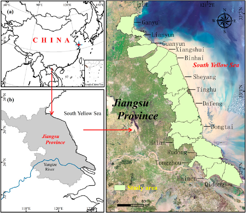
Figure 1. This is a figure. Schemes follow the same formatting.
This strategic location, coupled with its rich natural resources, underscores the importance of Jiangsu’s coastal zone in regional and national development, as well as in the ecological balance of the eastern coastal area of China. Quantitative analysis reveals that 35% of the coastal zone is classified as high-intensity human activity areas, characterized by population densities exceeding 128.28 persons/km2 and urbanization levels above 67.1% (Fang et al., 2025). The coastal area of Jiangsu Province is expansive and ecologically diverse, making it crucial to define clear study boundaries for a comprehensive assessment (Cui et al., 2021). For this study, we delineated the coastal zone by taking the boundary of Jiangsu Province along the Yellow Sea as the coastline, encompassing 14 county-level administrative districts, including Ganyu District and Lianyun District. This selection ensures that the study covers a wide range of natural elements, providing a holistic view of the region’s ecological and environmental conditions. Moreover, this approach allows for a clearer understanding of management and development responsibilities, while also facilitating the accessibility of relevant data and the efficient handling of assessment indicators.
2.2 Research methods
2.2.1 Construction of coastal zone vulnerability assessment index system in Jiangsu Province
When considering coastal zone vulnerability, a variety of complex and diverse factors need to be taken into account. In order to more accurately reflect the actual situation of coastal zones in Jiangsu Province, we constructed an evaluation index system based on four constructive principles: scientific, systematic, differentiated and operational. This system combines previous research results as well as various public information and data. We started from three dimensions: 1) Coastal zone basic conditions, 2) coastal ecological environment, and 3) Coastal human activities. Under these three dimensions, we selected 14 key indicators, such as coastal wetland types and cover conditions, to comprehensively assess the vulnerability of the coastal zone in Jiangsu Province.
2.2.2 Selection of indicators
In this study, a modified AHP-PSO optimization algorithm was used to determine the criterion and index weights of the coastal zone. The AHP component allowed for subjective expert input, while PSO optimized the weights to minimize inconsistency. This hybrid approach addresses the limitations of traditional AHP, which often struggles with human bias and judgment matrix inconsistency (China Earthquake Data Center, 2022). The details are shown in Table 1.
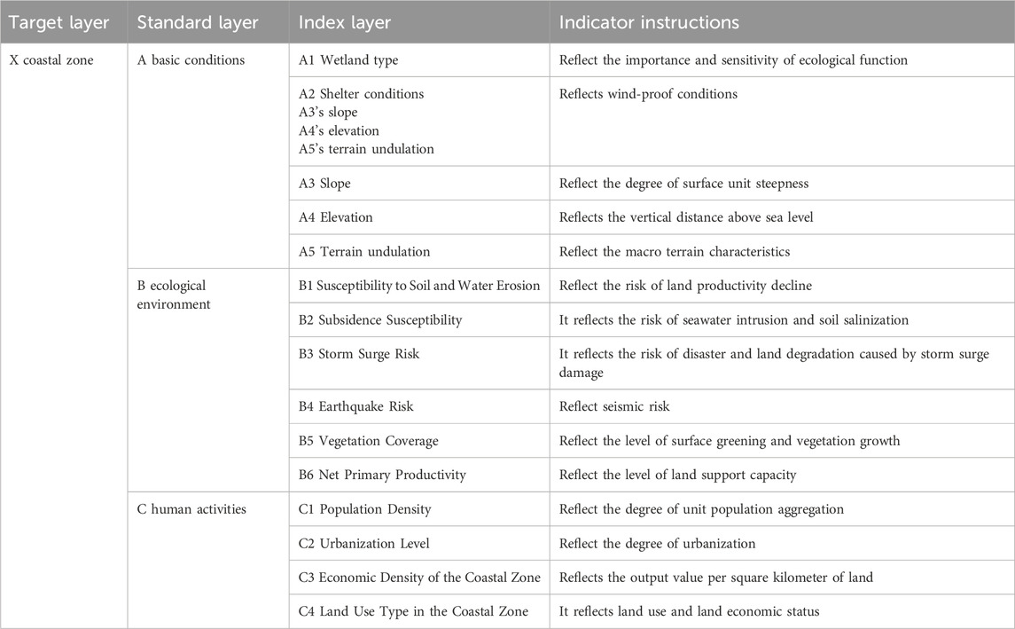
Table 1. Coastal zone evaluation index system of Jiangsu Province.
The indicators were selected based on a combination of expert judgment and literature review. A panel of 12 experts in coastal ecology, geography, and environmental science rated the relevance of each indicator using a Likert scale (1–5), with scores ≥4 considered significant. This process ensured alignment with Jiangsu’s specific vulnerabilities, such as land subsidence and wetland degradation, which are not fully captured by generic frameworks like DPSIR (Maloney and Preston, 2014).
A, “basic conditions”, describes the natural adaptive and resilient capacity of the coastal zone; B, “ecological environment”, looks at the resources, state of the environment and possible disaster risks in the coastal zone; and C, “human activities”, assesses how people’s activities are affecting the zone. The coastal zone boundary and base map vector data used in this study were obtained from the China Earth System Science Data Center (CSDSDC), specifically the Yangtze River Delta 1:250,000 basic geographic information dataset on the China Science and Technology Basic Condition Platform (CSTBCP) (website: http://www.gedata.cn). The dataset covers three provinces and one city in the YRD region, covering administrative boundaries, water systems, settlements and other elements. Apart from that, the dataset also provides layers of water system, inhabitants and facilities and transportation. In order to maintain a uniform standard, all data have been converted or adopted the WGS84 UTM 52N projection and are based on China’s National Elevation Datum of 1985. The assignment criteria for each evaluation index are shown in Table 2.
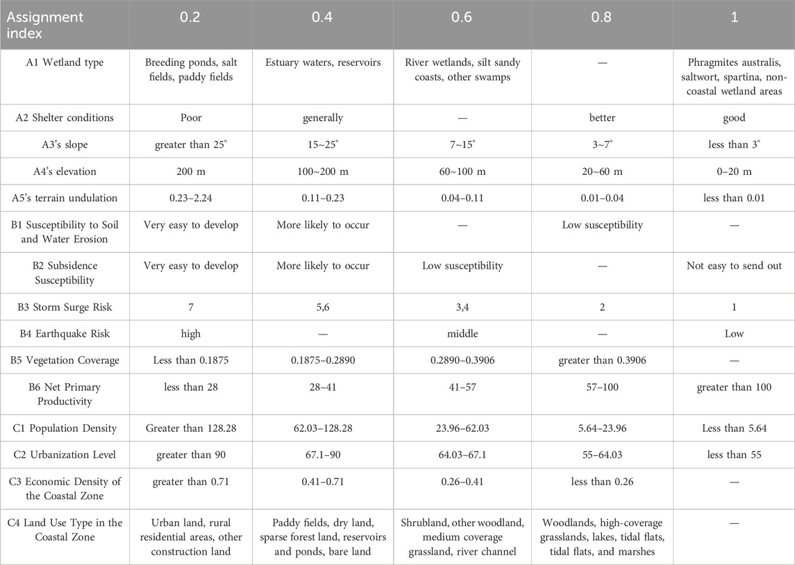
Table 2. Assignment criteria for each indicator.
A1 wetland type is coastal wetland type, and the data comes from the status data of coastal wetland in Jiangsu Province of Zhang and Lijie (2017).The A2 criterion, “Shelter Conditions,” delineates the protective features of the coastal zone against wave actions in its longitudinal direction. Considering the abundance of tidal flats and sandbanks in the Jiangsu offshore region, this study opted against the direct use of isobaths and shoreline curvature for shelter condition evaluation. Instead, a visual assessment method was employed to ascertain the area of sandbanks located offshore of the Jiangsu coastline, as well as their distance from the shoreline. Integrating considerations of shoreline curvature and the distribution of external sandbanks, the study comprehensively identified the shelter conditions of the coastal zone, utilizing county-level administrative divisions as the units of analysis. Data pertaining to A3’s slope, A4’s elevation, and A5’s terrain undulation were obtained from the ASTER GDEM V3 edition (2019) available on Japan’s METI website (GDEM, 2022), which offers a resolution of 30 m and was utilized for slope data extraction within the research area.
For B1 “Susceptibility to Soil and Water Erosion” and B2 “Subsidence Susceptibility,” the respective data were sourced from the “Environmental Capacity and Suitability for Land Development Assessment” conducted by the Jiangsu Environmental Science Research Institute in 2017. The data for B3 “Storm Surge Risk” was derived from the “China Historical Typhoon Best Track Dataset (1949–2019)” provided by the Tropical Cyclone Data Center of the China Meteorological Administration, accessible at (China Meteorological Administration, 2022). This dataset facilitated the quantification of direct typhoon landfalls and close passages for 14 county-level administrative units along the Jiangsu coast from 1949 to 2019, subsequently determining their storm surge risk levels.
B4’s “Earthquake Risk” data originates from the “Seismic Ground Motion Parameter Zoning Map of China (GB18306-2015)” published by the Institute of Geophysics of the China Earthquake Administration, details of which can be found on their official website (China Earthquake Data Center, 2022).
B5’s “Vegetation Coverage” data is retrieved from the MODIS13Q1 Vegetation Index dataset for Jiangsu Province (2016), available on the official website of the National Earth System Science Data Center, part of China’s National Science and Technology Infrastructure Platform (National Geomatics Center of China, 2022).
B6’s “Net Primary Productivity” data is acquired from the USGS’s MODIS MOD17A3HGF NPP dataset (U.S. Geological Survey, 2020), specifically from the h27v5 and h28v5 tiles.
For C1, “Population Density” data is sourced from Worldpop’s official website, specifically from the Worldpop population grid dataset for the year 2020 with a 100 m resolution (WorldPop, 2022).
C2’s “Urbanization Level” and C3’s “Economic Density of the Coastal Zone” data are both derived from the “Jiangsu Provincial Statistical Yearbook 2020,” published by the Jiangsu Provincial Bureau of Statistics, available at (Jiangsu Provincial People’s Government, 2022).
C4’s “Land Use Type in the Coastal Zone” data comes from the “2020 Jiangsu Province Land Use Data Product” released by the Geographic Monitoring Cloud Platform, accessible at (Data Sharing Infrastructure of Earth System Science, 2008).
2.2.3 Weight calculation of the index
In this study, a modified AHP-PSO optimization algorithm was used to determine the criterion and index weights of the coastal zone (Awad et al., 2011). The index weight determination steps are shown as follows:
(1) Create the judgment matrix. In matrix A, where the elements ui and uj (i, j = 1, 2, …, n) represent factors, the entry uij signifies the relative importance of factor ui compared to factor uj. Subsequently, construct the judgment matrix P based on matrix A-U. See Formula 1 for details.
(2) Computational importance ranking is conducted based on the judgment matrix. To identify the eigenvector w corresponding to the maximum characteristic root λmax, the following equations are utilized (Formula 2):
The sought eigenvector w is normalized, which is the importance of each evaluation factor, that is, weight allocation.
(3) To assess the reasonableness of the weight allocation obtained earlier, it is essential to conduct a conformity test on the consistency of the judgment matrix. This test employs the following Formula 3:
The Conformity Ratio (CR) for the judgment matrix and the Consistency Index (CI) can be calculated using the following Formula 4:
The Random Index (RI) is the average random consistency indicator of the judgment matrix. Judgment matrix P is considered to have satisfactory consistency when CR < 0.1 or when λmax equals n and CI equals 0. If these conditions are not met, adjustments to the elements in P should be made to achieve satisfactory consistency.
(4) Particle swarm optimization (PSO)
Due to the high subjectivity of expert scoring in hierarchical analysis, scoring matrices often exhibit inconsistencies or omissions. In such cases, the particle swarm optimization algorithm can be employed to rectify the expert scoring matrix.
(5) Overall hierarchical ranking test
The hierarchical total sorting step involves sorting from top to bottom, culminating in the calculation of the lowest element, which represents the relative priority weight of the decision scheme. Following these steps, we can generate the intermediate weight table for group decision, as illustrated in Table 3.

Table 3. Intermediate weight table of coastal zone group decision-making.
Finally, the underlying conclusion (weight) table of the group decision of the coastal zone is obtained, and the index weight and criterion weight table of the coastal zone is also obtained, as shown in Table 4.
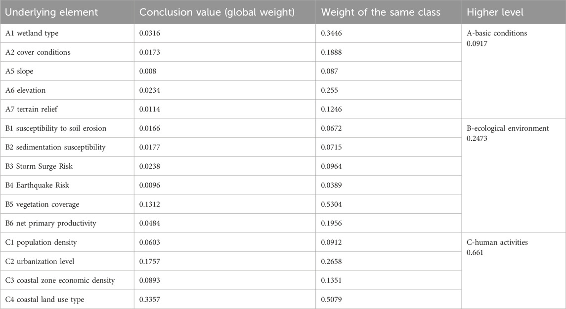
Table 4. Weight table of coastal zone evaluation indicators.
The weights reflect expert consensus on Jiangsu’s unique vulnerabilities. For example, human activities (C) received the highest weight (0.661), emphasizing their dominant role in shaping vulnerability. Within human activities, land use type (C4) was most influential (0.3357), aligning with previous studies linking urbanization to coastal degradation (Zhuang et al., 2024).
2.2.4 Vulnerability level classification
Using GIS software space analysis function of the grid calculator, the single factor index grid data superposition statistical analysis, according to the criterion within the index weight weighted superposition analysis, can get the coastal zone basic conditions, ecological environment and the evaluation results of human activity grid, according to the index global weight calculation, can get the coastal zone vulnerability evaluation results grid. Model validation was performed by comparing vulnerability outputs with historical records of storm surges (1949–2019) and land subsidence events, demonstrating significant spatial overlap between high-vulnerability zones and areas historically affected by typhoon-induced flooding (e.g., Sheyang County in 2016) (Wang K. et al., 2021). Additionally, a Pearson correlation coefficient of 0.78 was observed between our results and a 2018 provincial vulnerability assessment, confirming consistency with existing datasets.
This study divided the coastal zone vulnerability assessment into the following five levels: (1) Low vulnerability (value 5), less coastal zone natural environment pressure, good ecological environment, or good biodiversity, less affected by natural disasters, good coastal cover conditions, and less affected by typhoons. (2) Low vulnerability (value 4), the natural environmental pressure in the coastal zone is basically controllable, and there is some interference in human activities in this region, but the intensity of human activities has not exceeded the carrying capacity of resources and environment in the region, so it is less affected by natural disasters. (3) Medium and fragile (assigned value 3), the natural environment of the coastal zone is under greater pressure, the intensity of human activities is large, the underlying surface properties are general, the vegetation coverage is general, the cover conditions are general, and may be affected by various natural disasters. (4) high fragile (value 2), coastal natural environment pressure is bigger, human activity intensity, the coastal cover condition is poor, biodiversity is threatened, underlying surface change, cover condition is poor, shoreline erosion is relatively serious, in the climate warming, land subsidence and sea level rise background, prone to soil salinization, easily under the influence of storm surge and larger waves. (5) The highest vulnerability (assigned 1), the environmental pressure of the coastal zone is great, the human development of the coastal zone is great, mostly urban land, reclamation, industrial land, etc., biodiversity is greatly damaged, poor cover conditions, easy to be affected by wind and waves, very vulnerable to ground subsidence.
3 Results
3.1 Results of the single-parameter assessment
3.1.1 Spatial differences in the underlying conditions in the coastal zones
As depicted in Figure 2, this study utilized the raster calculator in ArcGIS 10.5 to perform a weighted overlay analysis on the study area based on the assigned weights of the underlying conditions. Higher scores in these base conditions indicate more favorable conditions. The evaluation of the coastal zone in Jiangsu Province revealed that the scores for underlying conditions range between 0.3356 and 1. Notable spatial differences are evident across the region.In the north-south direction, the coastal zone generally exhibits higher base condition scores in the northern and southern parts, with lower scores observed in the central region. In the east-west direction, the inland areas tend to have higher scores compared to the coastal regions. High-value concentrations of base conditions in Jiangsu’s coastal zone are found in the following areas, moving from north to south: (1) The flat topographic zone of Ganyu District, (2) The inland region of Lianyun District, (3) The western side of the Linhai Highway in Dafeng City, (4) The western side of the Linhai Highway in Dongtai City, (5) The urban area of Hai’an, (6) The inland area west of the Linhai Highway in Rudong County, and (7) The Tongzhou District. These areas generally feature flat terrain with minimal topographic relief, and the presence of large bays or sandbars offshore provides substantial natural protection for the coastal zones, making them less vulnerable to storm surges.
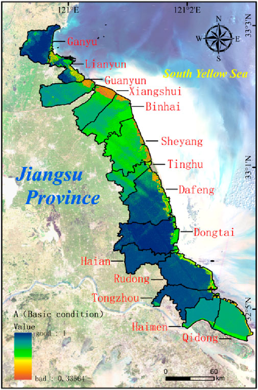
Figure 2. Spatial distribution characteristics of basic conditions in the coastal zones of Jiangsu Province.
The areas of low-value concentration of coastal zone base conditions in Jiangsu Province are, from north to south: (1) Guanyun County shoreline near the Guanxi Salt Farm, Guanyun Lingang Industrial Zone, and Yanwei Harbor Town. (2) Chenjiagang Town near the shoreline of Lingshui County, Jiangsu Province Gudong Farm, and Jiangsu Province Huanghai Farm. (3) Coastal Industrial Park and Xintan Salt Farm in the Development Zone of the abandoned Yellow River Delta region in Binhai County. (4) Linhai Town, Linhai Farm, Sheyang Harbor Economic Zone, and Huangshagang Town near the shoreline of Sheyang County. The reason is that the land elevation in the above areas is too low, with the vast majority of the areas having an elevation of less than 1 m, and they are located in the area of the Abandoned Yellow River Delta, where the land protrudes towards the sea, and the conditions of cover are poorer.
3.1.2 Score status of coastal zone ecological environment indicators
As shown in Figure 3, using the raster calculator of ArcGIS 10.5, the study area was analyzed by weighted superposition according to the sibling weights of the ecological environment indicators, and the higher the ecological environment score, the better. It can be seen that the ecological environment evaluation score of the coastal zone in Jiangsu Province is between 0.2862 and 0.8612.
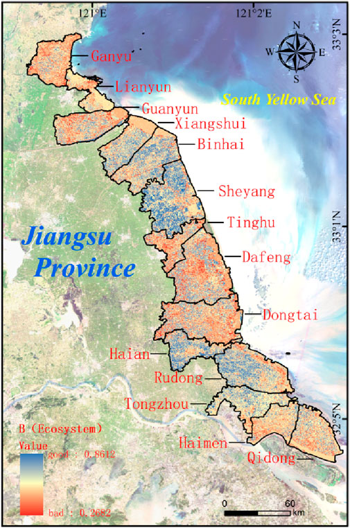
Figure 3. Spatial distribution characteristics of the ecological environment in the coastal zone of Jiangsu Province.
The ecological environment of the coastal zone in Jiangsu Province exhibits a complex and uneven spatial distribution. The analysis reveals significant spatial differences, particularly along the north-south axis, where ecological environment scores alternate between high and low values. This staggered pattern reflects the varying degrees of ecological health and environmental stressors across different regions.
In the north-south direction, areas with high ecological environment scores are predominantly located in Binhai County, Sheyang County, Haian City, and Rudong County. These regions benefit from extensive vegetation cover, stable geological conditions, and the absence of active fault lines. Additionally, the presence of paddy fields contributes to high net primary productivity, enhancing the ecological resilience of these areas. The robustness of the natural environment in these regions is further supported by effective land management practices that prioritize ecological conservation.
Conversely, low ecological environment scores are concentrated in the central urban and port areas of Lianyun District, as well as the urban centers of Ringshui County, Tinghu District, Dafeng District, Dongtai City, and Haimen District. These areas are heavily impacted by human activities, such as urbanization, industrial development, and intensive land use, which have led to significant ecological degradation. High population density and the proximity to urban construction zones have resulted in substantial alterations to the natural landscape, reducing the productivity of the land and increasing the vulnerability of these regions to environmental stressors.
Moreover, the large-scale extraction of groundwater in these low-scoring areas has exacerbated the risk of surface subsidence, further destabilizing the ecological environment. Reclamation activities in coastal wetlands, aimed at expanding urban and industrial spaces, have significantly diminished the ecosystem services provided by these wetlands, such as flood control, water purification, and habitat provision. This degradation not only threatens biodiversity but also undermines the long-term sustainability of the coastal zone’s ecological balance.
In the east-west direction, the distribution of ecological environment scores is relatively uniform, with fewer drastic changes observed. However, this apparent uniformity masks underlying variations in ecological quality, driven by localized factors such as land use practices, coastal management strategies, and environmental protection policies. The subtle differences in scores along this axis highlight the importance of tailored conservation efforts that address the specific needs and challenges of each coastal segment.
In summary, the ecological environment of Jiangsu Province’s coastal zone is characterized by a dynamic interplay between natural factors and human influences, leading to a mosaic of ecological conditions that require differentiated management and restoration strategies to ensure the long-term health and resilience of the region.
3.1.3 Score status of human activity indicators in the coastal zone
As shown in Figure 4, using the raster calculator of ArcGIS 10.5, the study area was analyzed by weighted superposition according to the sibling weights of the anthropo-genic activity indicators, and the resultant scores were as high as possible. It can be seen that the evaluation score of human activities in the coastal zone of Jiangsu Province is between 0.1817 and 0.8.
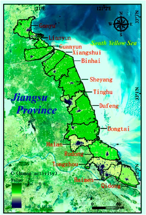
Figure 4. Spatial distribution characteristics of human activities in the coastal zone of Jiangsu Province.
The spatial distribution of human activities across Jiangsu Province’s coastal zone, reveals significant clustering, highlighting a complex interaction between natural landscapes and anthropogenic pressures. The evaluation indicates that human activity intensity varies significantly in both the north-south and east-west directions, reflecting the diverse socioeconomic dynamics within the region.
In the north-south direction, there is an alternating pattern of high and low human activity intensity. High-intensity areas, characterized by dense human activity, are often found in regions where economic development has driven significant land use changes. For example:
Yuntai Mountain Scenic Area in Lianyun District: This area, known for its tourism and recreational activities, has seen substantial human intervention, including infrastructure development and environmental modifications to accommodate visitors.
The Old Yellow River Channel in Guanyun County: Historically significant, this area has undergone extensive anthropogenic alteration, transforming it into a focal point for both cultural heritage and economic activities, particularly in agriculture and tourism.
Huangsha Harbor in Sheyang County: This region has developed into a key industrial and logistical hub, with activities focused on shipping, fishing, and related industries, driving high human activity scores.
Coastal Economic Zone of Snares Town, Dongtai City: As an economic development zone, this area has experienced rapid industrialization, leading to significant changes in land use and increased human activity intensity.
Yangkou Town in Rudong County: Known for its strategic location and port facilities, Yangkou Town has attracted substantial investment in logistics, manufacturing, and energy, contributing to its high human activity scores.
In contrast, the central urban districts, which one might expect to be hotbeds of human activity, display relatively low scores. These districts include: The central urban district of Ganyu, The central urban district of Lianyungang, The central urban district of Tinghu, The central urban district of Hai’an, The central urban district of Tongzho.
These regions, serving as administrative and economic centers, exhibit lower human activity scores due to the saturation of development and the consequent environmental degradation. The centralization of administrative functions and the concentration of industrial activities have led to significant alterations in the natural landscape. These changes include extensive urbanization, land cover modifications, and the loss of green spaces, which, paradoxically, result in lower human activity scores in the evaluation model due to the diminished ecological quality and reduced capacity for further development.
The east-west variation in human activity intensity further accentuates the inland-coastal divide, with inland areas typically showing higher activity levels. This pattern is largely driven by the inland regions’ accessibility and suitability for large-scale industrial and agricultural activities, compared to the more ecologically sensitive coastal areas, where development is often constrained by environmental regulations and conservation efforts.
In summary, the spatial distribution of human activities in Jiangsu Province’s coastal zone underscores the intricate balance between economic development and environmental sustainability. The observed patterns reflect not only the direct impact of human activities on the landscape but also the broader socio-economic strategies that prioritize certain areas for development while preserving others for ecological integrity.
3.2 Results of the comprehensive evaluation of coastal zone vulnerability
3.2.1 Overall spatial characteristics of coastal zone vulnerability
Using the Raster Calculator of ArcGIS 10.5, a weighted overlay analysis was per-formed on the various vulnerability indicators of Jiangsu Province’s coastal zone by global weighting factors. This process aimed to calculate the Vulnerability Index of Jiangsu Province’s coastal zone. Subsequently, the Vulnerability Index was categorized into five distinct classes using the natural break method. These classes were assigned numerical values of 1, 2, 3, 4, and 5, representing different levels of coastal vulnerability: low, relatively low, moderate, relatively high, and high. Finally, the reclassified Vul-nerability Index results were overlaid to generate a spatial characteristic map of coastal vulnerability for Jiangsu Province, as depicted in Figure 5.
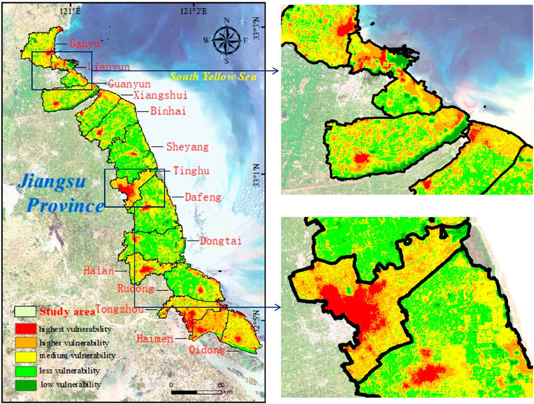
Figure 5. Spatial distribution characteristics of vulnerability in the coastal zone of Jiangsu Province.
Figure 5 illustrates pronounced differences in the distribution of vulnerability between land and sea within the coastal zones of Jiangsu Province. The spatial distribution of coastal vulnerability is highly fragmented, reflecting a complex interplay between natural and anthropogenic factors. Notably, areas with high vulnerability are concentrated in specific inland regions, which aligns with the patterns observed in the assessment of human activities. This suggests that areas heavily influenced by human intervention are more prone to environmental degradation and higher vulnerability.
The inland regions, in particular, exhibit a markedly higher vulnerability compared to coastal areas. This disparity is likely driven by intense human activities such as urbanization, industrialization, and agricultural expansion, which exert substantial pressure on the local environment. Key areas with concentrated high vulnerability include Qingkou Town in Ganyu District, Haikouwan Street and Zhongyun Street in Lianyun District, Yishan Town in Guanyun County, Ringshui Town in Xiangshui County, and Dongkan Town in Binhai County. These areas are characterized by dense population, economic development zones, and extensive land-use changes, all of which contribute to their heightened vulnerability.
Further statistical analysis of the vulnerability classes across the coastal zone reveals significant disparities in their distribution. High vulnerability areas cover a total of 1,256.39 km2, representing 5.49% of the coastal zone. Areas of higher vulnerability span 4,842.15 km2, accounting for 21.15% of the total area. The majority of the coastal zone falls within the medium vulnerability category, extending over 8,997.89 km2, which constitutes 39.31% of the area. In contrast, lower vulnerability areas make up 7,333.94 km2, or 32.04% of the coastal zone. Finally, regions with the lowest vulnerability cover only 461.39 km2, equivalent to 2.02% of the total area.
This analysis highlights the critical need for targeted ecological restoration and management strategies, particularly in the highly vulnerable inland areas, to mitigate the adverse effects of human activities and to promote sustainable development in Jiangsu’s coastal zones.
3.2.2 Overall spatial characteristics of coastal zone vulnerability
To achieve a thorough understanding of the vulnerability characteristics across different county-level administrative units within Jiangsu Province’s coastal zone, we performed systematic statistical analyses from north to south. These analyses assessed the percentage distribution of vulnerability levels within each unit and calculated the ratio of vulnerable areas to the total area. The results are visually represented in Figure 6, revealing significant insights into the spatial patterns of vulnerability.
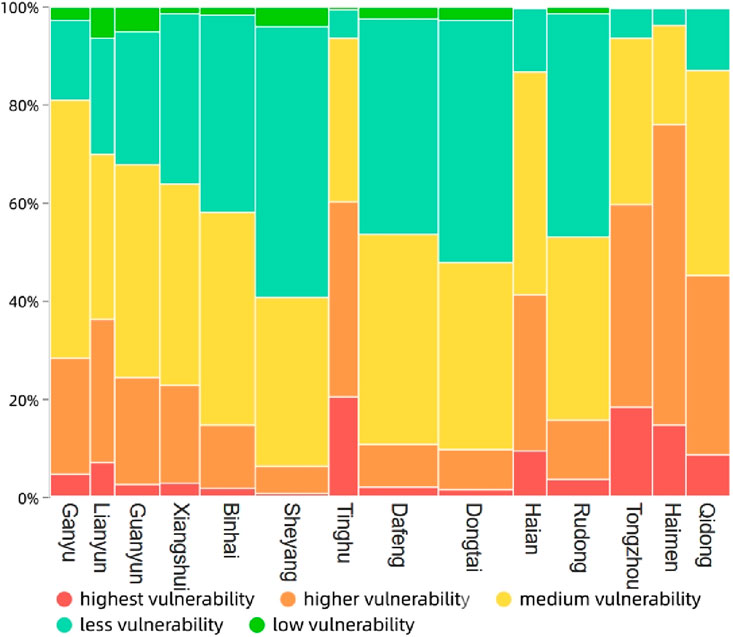
Figure 6. Column diagram of the percentage accumulation of counties and cities in the coastal zones of Jiangsu Province.
The distribution of mean vulnerability values exhibits a clear gradient, with vulnerability levels progressively increasing from the southern to the northern parts of the coastal zone. This trend aligns with previous studies in China’s Yangtze River Delta, where rapid urbanization and industrial expansion have been linked to heightened vulnerability in northern sub-regions (Song et al., 2023). However, unlike the Pearl River Delta, where coastal areas are more vulnerable due to intensive port activities and urban sprawl (Cao et al., 2022), Jiangsu’s inland regions (e.g., Ganyu, Lianyun) demonstrate higher vulnerability due to land subsidence and groundwater overexploitation. This finding also contrasts with global coastal zones such as Bangladesh’s Sundarbans, where vulnerability is primarily driven by cyclones and sea-level rise (Mohammed et al., 2024).
In contrast, the central part of Jiangsu’s coastal zone (e.g., Dafeng, Dongtai) displays relatively low vulnerability levels, with minimal variations among administrative units. This stability mirrors the resilience observed in Florida’s Gulf Coast, where balanced ecosystem management and adaptive policies have mitigated climate risks (Maloney and Preston, 2014). However, unlike Florida’s focus on storm surge infrastructure, Jiangsu’s central region benefits from natural buffers like tidal flats and strategic land-use planning, which limit human encroachment (Zhuang et al., 2024).
Most county-level administrative units in Jiangsu’s coastal zone are characterized by medium vulnerability, with substantial portions of their land area exhibiting this level of risk. However, several units, including Lianyun District and Qidong City, are dominated by medium to high vulnerability. This pattern resembles the vulnerability hotspots identified in Vietnam’s Mekong Delta, where urbanization and agricultural intensification exacerbate environmental stress (Yuen et al., 2021). Unlike Vietnam, however, Jiangsu’s vulnerability is further compounded by industrial pollution and reclamation activities, which degrade wetland ecosystems (Zhai et al., 2021).
This spatial analysis underscores the need for targeted interventions in the northern and certain central regions, where vulnerabilities are more pronounced. Implementing adaptive management strategies tailored to Jiangsu’s unique context, such as wetland restoration and sustainable urban planning, could mitigate the impacts of human activities and natural hazards, aligning with global best practices in deltaic regions (Wang et al., 2024).
4 Targeted strategies for ecological restoration and sustainable development in Jiangsu’s coastal zones
The coastal zone of Jiangsu Province is a dynamic and ecologically diverse region, characterized by significant spatial variations in its ecological landscape from north to south. Given the critical importance of this region to both the local environment and economy, protecting and restoring its ecological integrity is paramount. However, broad and generalized strategies are insufficient to address the complex challenges faced by this coastal area. Instead, a more targeted approach is necessary—one that considers the unique ecological, social, and economic characteristics of different sub-regions within Jiangsu’s coastal zone. This section proposes a set of strategic, targeted measures aimed at enhancing the ecological resilience of Jiangsu’s coastal zones, focusing on specific areas that require immediate attention.
4.1 Enhancing and future-proofing the coastal infrastructure
Enhancing and future-proofing the coastal infrastructure in Jiangsu Province is a pressing need, given the region’s critical economic role and its exposure to significant environmental challenges. The current infrastructure in this coastal region exhibits noticeable spatial disparities, particularly between the northern, central, and southern areas. Addressing these disparities, alongside the broader challenge of future-proofing the infrastructure against climate change, is essential for sustainable development. The infrastructure must not only support ongoing economic activities but also provide robust defenses against the increasing frequency and intensity of climate-related events, such as sea-level rise and storm surges.
The existing infrastructure in Jiangsu’s coastal zone faces multiple challenges, including spatial disparities, aging facilities, insufficient resilience, and limited connectivity. These challenges are compounded by the fact that northern and southern regions have seen more concentrated development efforts, leaving central areas underdeveloped. This uneven distribution exacerbates regional vulnerabilities, particularly as much of the infrastructure was not designed to withstand current environmental stresses. Roads, bridges, and water management systems, in particular, are in urgent need of upgrades to meet modern demands and to ensure they can withstand the impacts of climate change.
A comprehensive strategy to enhance and modernize the infrastructure in Jiangsu’s coastal zone must address these challenges through a multi-faceted approach. This includes ensuring balanced regional development by directing resources to both northern and southern regions while giving special attention to the underdeveloped central areas. Upgrading existing infrastructure to enhance its resilience against future climate-related impacts is crucial. This includes reinforcing critical infrastructure such as roads and bridges, improving drainage systems, and constructing seawalls where necessary. The integration of green infrastructure, such as wetlands and mangroves, offers a natural defense against coastal erosion and storm surges and should be an integral part of the overall strategy.
Improving connectivity within the coastal zone is another essential aspect of this strategy. Enhancing east-west connectivity through new transport corridors, including highways and railways, will not only boost economic integration but also improve disaster response capabilities and access to critical services. The development of multi-modal transport networks that integrate road, rail, and sea transport will further optimize the movement of goods and people, providing alternative routes and modes of transport during emergencies and reducing the region’s overall vulnerability.
To fund these large-scale infrastructure projects, Jiangsu Province should explore the potential of public-private partnerships (PPPs), which can attract private sector investment, expertise, and efficiency. Encouraging PPPs can accelerate the development of critical infrastructure, while innovative financing models such as infrastructure bonds or green bonds can provide sustainable funding mechanisms, particularly for projects aimed at enhancing climate resilience and sustainable development. These models can be effective in securing the necessary capital to drive long-term infrastructure improvements.
Sustainability and resilience should be at the core of all future infrastructure projects. This involves incorporating sustainable design principles, such as using materials and construction techniques that minimize environmental impact, promoting energy efficiency, and ensuring that projects do not exacerbate existing ecological vulnerabilities. Climate adaptation measures should be embedded in all infrastructure developments, ensuring that new projects are designed to adapt to rising sea levels, increased rainfall, and more frequent extreme weather events. Flexible and adaptive infrastructure will be key to maintaining functionality in the face of unpredictable future conditions.
Involving local communities and stakeholders in the planning and implementation of infrastructure projects is essential for their success. Inclusive decision-making processes ensure that infrastructure developments meet the needs of the populations they serve and enhance social acceptance and long-term viability. Strengthening governance frameworks and regulatory oversight is also critical, as it ensures that infrastructure projects adhere to high standards of quality, safety, and environmental protection.
Looking ahead, Jiangsu Province has the potential to become a model for coastal resilience and sustainable infrastructure development. By addressing current disparities and vulnerabilities with a forward-looking approach, the province can create a resilient and thriving coastal region. This vision includes a robust coastal economy, protected from climate change impacts, sustainable urbanization supported by resilient infrastructure, and an integrated disaster management system that enhances the region’s ability to respond to and recover from natural disasters swiftly. Incorporating green and blue infrastructure into the built environment will further strengthen Jiangsu’s defenses against climate impacts while promoting biodiversity and ecological health. As Jiangsu strengthens its coastal infrastructure, it can position itself as a leader in sustainable coastal development, sharing its experiences and innovations with other regions worldwide facing similar challenges.
In conclusion, the enhancement and future-proofing of coastal infrastructure in Jiangsu Province require a comprehensive, multi-dimensional approach. By focusing on balanced regional development, modernizing existing infrastructure, enhancing connectivity, leveraging public-private partnerships, integrating sustainability, and involving local communities, Jiangsu can build a resilient, sustainable, and prosperous coastal zone. This effort will not only protect the region from current and future environmental threats but also ensure that it remains a vital economic hub for China and the world.
4.2 Regional afforestation and reforestation
One of the most pressing needs for Jiangsu’s coastal zone is the implementation of targeted afforestation and reforestation programs. In the northern regions, where industrial activities have led to significant deforestation and degradation of natural habitats, reforestation efforts should focus on restoring native vegetation and re-establishing ecological corridors. These corridors are essential for maintaining biodiversity and enabling species migration, especially in the face of climate change.
In the southern regions, where the coastal landscape is heavily influenced by agricultural activities, afforestation efforts should prioritize the creation of shelterbelts and windbreaks to reduce soil erosion and protect inland areas from saltwater intrusion. These green barriers will also serve to enhance carbon sequestration, contributing to the region’s efforts to mitigate the effects of climate change. In both cases, the selection of tree species should be based on their ecological suitability, resilience to local climatic conditions, and potential to support local wildlife.
4.3 Wetland preservation and restoration
Wetlands are among the most valuable ecosystems in Jiangsu’s coastal zone, providing critical services such as water filtration, flood regulation, and habitat for a diverse array of species. However, these areas have been significantly impacted by urbanization, industrial development, and agricultural expansion. Satellite-based monitoring indicates that natural wetlands in Yancheng, a key coastal region in Jiangsu, have experienced conversion to artificial wetlands and non-wetland types due to human activities, with salt pans transforming into mudflats and herbaceous vegetation expanding at the expense of native habitats (Chen C. et al., 2022). The loss of tidal flats and salt marshes has also disrupted migratory routes for globally threatened waterbirds like the spoon-billed sandpiper, which rely on these ecosystems for stopover sites (Peng et al., 2017).
To address these challenges, a two-pronged approach to wetland preservation and restoration is recommended. First, stringent protection measures should be enacted to prevent further degradation of existing wetlands. This includes enforcing buffer zones around key wetland areas to limit the encroachment of agricultural and industrial activities. These buffer zones should be managed to enhance their ecological function, for instance by planting native vegetation such as Suaeda salsa and Phragmites australis that can filter runoff and provide habitat for wildlife (Cui et al., 2018). Recent studies highlight that restoring buffer zones with native species can reduce nutrient runoff by 30%–40% and enhance biodiversity compared to conventional monoculture plantations (Jiang et al., 2023).
Second, where wetlands have been degraded or lost, restoration efforts should be undertaken to rehabilitate these ecosystems. This may involve reintroducing native plant species, re-establishing natural hydrological regimes, and removing invasive species like Spartina alterniflora that threaten the ecological balance. For example, in the Yellow Sea region, sediment management combined with native vegetation planting has successfully restored 1,200 ha of tidal flats, improving storm surge resilience and supporting fisheries productivity. Restoration efforts should also consider the potential impacts of climate change, such as sea-level rise, and incorporate adaptive management strategies. Modelling suggests that integrating dynamic hydrological controls into restoration plans can maintain wetland functionality under projected climate scenarios (Li et al., 2019).
4.4 Sustainable land-use planning
Sustainable land-use planning is crucial for balancing the competing demands of development and conservation in Jiangsu’s coastal zone. To achieve this balance, land-use planning efforts must be guided by a comprehensive understanding of the region’s ecological sensitivity and carrying capacity.
In high-vulnerability areas, particularly those identified in the northern and central parts of the coastal zone, strict land-use controls should be implemented to prevent further environmental degradation. These controls might include restrictions on industrial development, limits on the expansion of agricultural land, and the promotion of low-impact tourism and recreation activities. In these areas, land-use planning should prioritize the protection of natural habitats and the restoration of degraded ecosystems.
In areas of medium vulnerability, land-use planning should focus on promoting sustainable agricultural practices, such as organic farming and the use of agroforestry techniques, that can enhance the resilience of the landscape while supporting local livelihoods. In these regions, planners should also explore opportunities to integrate green infrastructure into urban development projects. Green infrastructure, such as green roofs, permeable pavements, and urban wetlands, can help mitigate the environmental impacts of urbanization by managing stormwater, reducing heat islands, and providing habitat for urban wildlife.
4.5 Integrated Coastal Zone Management (ICZM)
Integrated Coastal Zone Management (ICZM) is an essential framework for coordinating the various activities and interests that intersect in Jiangsu’s coastal zone. ICZM seeks to harmonize the environmental, economic, and social dimensions of coastal development, ensuring that the long-term health of the coastal environment is maintained.
In Jiangsu Province, the implementation of ICZM should begin with the establishment of a multi-stakeholder governance structure that includes representatives from local governments, industry, agriculture, conservation organizations, and local communities. This governance structure should be empowered to develop and enforce coastal management plans that reflect the region’s unique ecological and socio-economic conditions.
One of the key components of ICZM in Jiangsu should be the establishment of a coastal monitoring and data-sharing platform. This platform would facilitate the collection and dissemination of real-time data on environmental conditions, such as water quality, biodiversity, and land use, enabling stakeholders to make informed decisions and respond quickly to emerging threats. Additionally, the platform could serve as a repository for best practices in coastal management, providing valuable resources for local governments and communities seeking to implement sustainable development strategies.
4.6 Community engagement and capacity building
The success of any ecological restoration and conservation efforts in Jiangsu’s coastal zone will depend largely on the active participation and support of local communities. Therefore, community engagement should be a central component of the region’s environmental strategy. This can be achieved through a combination of education, outreach, and capacity-building programs.
Educational programs should be designed to raise awareness of the importance of coastal ecosystems and the benefits of sustainable land use among local residents. These programs could be delivered through schools, community centers, and public media, and should be tailored to address the specific environmental challenges faced by different parts of the coastal zone.
In addition to education, capacity-building programs should be developed to equip local communities with the skills and knowledge needed to participate in and benefit from conservation efforts. This might include training in sustainable agricultural practices, support for the development of eco-tourism businesses, and opportunities for community members to participate in monitoring and managing local natural resources.
4.7 Implementing Nature-Based Solutions
In the context of Jiangsu Province’s coastal region development, an emphasis is placed on the integration of Nature-based Solutions (NbS) as a pivotal strategy. NbS encompasses approaches that harness natural processes and ecosystems, aiming to address societal challenges while simultaneously yielding benefits for human wellbeing and biodiversity conservation (Figure 7). The International Union for Conservation of Nature (IUCN) has formulated eight core principles and twenty-eight specific criteria under the NbS framework, which are instrumental in tackling a spectrum of global challenges. These challenges include climate change adaptation, disaster risk reduction, food security, and water resource management. The application of NbS within Jiangsu’s coastal areas aligns with these principles and indicators, proposing a sustainable pathway that leverages the intrinsic value and functionality of ecosystems. This approach not only seeks to bolster environmental resilience but also ensures the sustainable utilization of ecosystem services, crucial for the long-term prosperity of the region (Sowińska-Świerkosz and García, 2022).
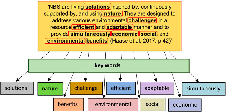
Figure 7. Conceptual framework of nature-based solutions (NbS).
This strategy encompasses the following key areas:
Ecological Restoration and Conservation (Table 5): Emphasizing the restoration and protection of coastal ecosystems like wetlands and mangroves. Initiating ecological restoration projects to repair damaged areas while safeguarding natural zones from development and pollution.
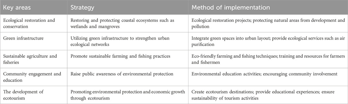
Table 5. Ecological protection and sustainable development strategy for the Jiangsu coastal zone.
Green Infrastructure: Strengthening urban ecological networks through features like bio-retention areas and green roofs. Integrating green spaces into urban planning to offer ecological services like air purification.
Sustainable Agriculture and Fisheries: Advancing agricultural and fishery practices that minimize ecological impacts and preserve biodiversity. Advocating eco-friendly farming and fishing techniques and providing training and resources to farmers and fishermen.
Community Participation and Education: Enhancing public awareness of environmental conservation. Conducting environmental education and encouraging community involvement in ecological conservation activities to increase public responsibility and participation.
Development of Ecotourism: Promoting environmental protection and economic growth through ecotourism. Establishing ecotourism destinations offering educational experiences while ensuring the sustainability of tourism activities.
5 Conclusion
5.1 Key findings
This study presents a comprehensive assessment of the vulnerability of Jiangsu Province’s coastal zone and suggests corresponding restoration strategies. By considering both the natural and human aspects of the coastal zone in Jiangsu Province, we defined the boundaries of the land and sea study area and employed ArcGIS 10.5 software to analyze multi-source data. An evaluation index system was developed, covering three dimensions: coastal zone fundamentals, ecological environment, and human activities. The findings of the study are as follows:
1. In evaluating the basic conditions of the coastal zone in Jiangsu Province, we found that the scoring interval was between 0.3356 and 1. Observing from the perspective of spatial distribution, the scores of the southern and northern regions are generally higher than those of the central region; while in the east-west comparison, the scores of the inland region exceed those of the coastal region
2. Concerning the assessment of the ecological environment in Jiangsu Province’s coastal zone, scores ranged from 0.2862 to 0.8612. In the north-south direction, the ecological environment scores exhibit a pattern of fluctuating high and low values, while in the east-west direction, they display a relatively uniform distribution.
3. Evaluation scores for human activities within the Jiangsu coastal zone varied between 0.1817 and 0.8. Regarding spatial distribution, in the north-south direction, human activity intensity shows an alternating pattern of high and low levels. Conversely, when analyzed in the east-west direction, human activity intensity in inland areas tends to be higher than that in coastal areas.
4. During the analysis of the comprehensive vulnerability of Jiangsu’s coastal zone, it was observed that the distribution exhibited a high degree of fragmentation, mirroring the evaluation results of human activities. Specifically, vulnerability in inland areas generally exceeded that in coastal areas. Following statistical analysis and synthesis, the vulnerability distribution in Jiangsu’s coastal zone is characterized by relatively higher vulnerability in the south and north, contrasted with lower vulnerability in the central region.
5.2 Comparison with global and national studies
Vulnerability hotspots in inland Jiangsu mirror trends in Vietnam’s Mekong Delta, where agricultural expansion and urbanization have increased environmental pressures. However, Jiangsu’s vulnerability is further exacerbated by industrial pollution and land reclamation activities, which have damaged key ecosystems such as tidal flats. In contrast, resilience in the central region is similar to that of Florida’s Gulf Coast, where strategic land-use planning and ecosystem management mitigate climate risks. Notably, Jiangsu’s vulnerability index correlates more strongly with indicators of human activity than with biophysical factors, highlighting the need for integrated socioeconomic and environmental strategies. This finding is consistent with global research advocating multidimensional vulnerability assessments.
5.3 Future research directions and focus
The vulnerability of coastal zones is a multifaceted issue, shaped by the complex interplay of natural and anthropogenic factors. While this study has provided significant insights into the spatial dynamics and ecological restoration strategies for the coastal zones of Jiangsu Province, there remain several areas that warrant further investigation to enhance the robustness of vulnerability assessments and the effectiveness of intervention strategies.
5.3.1 Integrating multi-scale temporal and spatial data
Future research should focus on integrating multi-scale temporal and spatial data to develop a more nuanced understanding of coastal vulnerability. Given that coastal zones are dynamic environments subject to continuous change, it is crucial to employ high-resolution temporal data to capture the short-term fluctuations in environmental conditions and human activities. Such data integration could involve the use of satellite imagery, drone surveillance, and ground-based monitoring systems to track changes in land use, vegetation cover, and shoreline dynamics over time. By combining these datasets with long-term historical data, researchers can identify patterns and trends that may not be immediately apparent in short-term studies, thereby providing a more comprehensive understanding of the factors driving vulnerability.
5.3.2 Assessing the impact of climate change scenarios
The future research agenda must also include the assessment of coastal zone vulnerability under various climate change scenarios. As global temperatures rise and sea levels increase, the coastal regions of Jiangsu Province will face new and heightened risks. Researchers should employ climate models to simulate the potential impacts of these changes on the region’s coastal ecosystems, infrastructure, and communities. This includes evaluating the resilience of different ecosystems to increased salinity, flooding, and erosion, as well as the effectiveness of current and proposed mitigation strategies under varying climate conditions. By understanding how different climate scenarios may affect coastal vulnerability, researchers can help policymakers prioritize resources and develop adaptive strategies that are both proactive and flexible.
5.3.3 Exploring socio-economic vulnerabilities
In addition to environmental factors, future research should delve deeper into the socio-economic vulnerabilities of coastal communities in Jiangsu Province. The interplay between economic development and ecological sustainability is particularly complex in coastal zones, where the demands of urbanization, industrialization, and tourism often conflict with environmental protection. A detailed analysis of the socio-economic drivers of vulnerability, such as income levels, employment patterns, and access to resources, can reveal critical insights into how different communities are likely to be affected by environmental changes. This research should also consider the social dimensions of vulnerability, including the capacity of communities to respond to and recover from environmental shocks. By identifying the most vulnerable populations and understanding the root causes of their vulnerability, future studies can inform more equitable and targeted policy interventions.
5.3.4 Developing adaptive management frameworks
Building on the findings of this study, future research should focus on the development of adaptive management frameworks that can be tailored to the specific needs and conditions of Jiangsu’s coastal zones. These frameworks should integrate scientific knowledge with local governance structures, enabling more responsive and context-sensitive management practices. Key components of such frameworks could include the establishment of flexible zoning regulations, the promotion of sustainable land-use practices, and the creation of economic incentives for conservation efforts. Moreover, these frameworks should be designed to incorporate feedback loops, allowing for the continuous adjustment of management strategies based on real-time data and changing conditions. This adaptive approach would not only enhance the resilience of coastal zones but also ensure that management practices remain relevant and effective in the face of evolving environmental and socio-economic challenges.
5.3.5 Establishing long-term monitoring and evaluation systems
Finally, there is a critical need for the establishment of long-term monitoring and evaluation systems to track the effectiveness of vulnerability mitigation and ecological restoration efforts in Jiangsu’s coastal zones. These systems should be designed to collect and analyze data on a wide range of indicators, including environmental health, economic performance, and social wellbeing. The use of advanced technologies, such as remote sensing, geographic information systems (GIS), and artificial intelligence, could greatly enhance the accuracy and efficiency of monitoring efforts. Furthermore, the integration of community-based monitoring initiatives could provide valuable local insights and foster greater stakeholder engagement in the conservation process. By systematically evaluating the outcomes of various interventions, researchers and policymakers can identify best practices, adjust strategies as needed, and ensure that the coastal zones of Jiangsu Province continue to thrive in the face of future challenges.
5.4 Study innovation points and cross-regional application potential
This study presents three innovative breakthroughs in the assessment and governance of coastal vulnerability in Jiangsu Province. Firstly, it constructs a three-dimensional assessment framework encompassing basic conditions, ecological environment, and human activities, breaking through the limitations of traditional single-dimensional assessments. By quantifying region-specific vulnerability factors such as land subsidence and saltmarsh degradation using an improved AHP-PSO algorithm, this framework enhances assessment accuracy while providing a replicable methodology for data-driven coastal zone management. Secondly, it reveals an anti-gradient distribution pattern of “high inland vulnerability and low central vulnerability” in Jiangsu’s coastal zone, identifying human activities as the dominant driver of vulnerability. This finding challenges the conventional perception that “coastal areas are inherently vulnerable” and offers a new perspective for identifying high-risk hotspots in industrialized regions such as the Pearl River Delta and the Mississippi Delta. Thirdly, the study proposes a collaborative strategy of “ecological restoration-infrastructure-community participation,” emphasizing the integration of wetland buffer zones and green infrastructure. Its flexible indicator-weighting mechanism provides adaptive solutions for coastal governance under complex human-land relationships.
These innovations enrich the theoretical connotations of coastal vulnerability research and offer practical application pathways for similar regions globally. Methodologically, the GIS overlay analysis and multi-source data integration used in this study can be rapidly adapted to temperate coastal zones with high population density, flat topography, and weak shoreline protection—such as the Mississippi River Delta and the Dutch coast—by replacing region-specific indicators. In terms of governance models, the dual-governance model of government leadership and community participation leverages low-cost adaptability, combining government policy coordination with local community engagement to address governance resource shortages in developing countries. For highly urbanized regions like China’s Pearl River Delta, the concept of “cross-administrative-unit vulnerability collaborative assessment” can promote “joint prevention and control” in flood protection infrastructure and ecological restoration through unified indicator systems and data-sharing platforms. Ecologically, the designs of “intertidal vegetation buffer zones” and “industrial ecological buffer zones” in Jiangsu provide localized references for vegetation configuration and development control in ecologically sensitive areas like the Mekong Delta and industrialized regions such as New York-New Jersey Harbor. Through the logical chain of “theoretical innovation-methodological migration-strategic adaptation,” this study contributes scientific and practical Chinese experiences to global coastal governance, particularly demonstrating significant application value for temperate low-lying coasts facing similar human-land conflicts.
Data availability statement
Publicly available datasets were analyzed in this study. This data can be found here: U.S. Geological Survey (2020). MOD17A3HGF. Retrieved 2022-09-05, from https://e4ftl01.cr.usgs.gov/MOLT/MOD17A3HGF.006/2020.01.01/.
Author contributions
JH: Formal Analysis, Investigation, Project administration, Writing – original draft, Writing – review and editing. BL: Conceptualization, Data curation, Formal Analysis, Funding acquisition, Investigation, Methodology, Project administration, Resources, Software, Supervision, Validation, Visualization, Writing – original draft, Writing – review and editing. WL: Conceptualization, Methodology, Writing – original draft, Writing – review and editing. NY: Conceptualization, Writing – original draft, Writing – review and editing.
Funding
The author(s) declare that financial support was received for the research and/or publication of this article. This research was funded by the Research funding for the 2024 Green seedling Program of the Human Resources and Social Security Department of Guangxi Zhuang Autonomous Region, China (60203038919630213), Nanning Normal University Demonstration Modern Industrial College (No. 6020303891920), Nanning Normal University Characteristic Undergraduate College Construction and College Teaching Quality and Reform Engineering Project—Undergraduate Education and Teaching Key Project (No. 6020303891924), Nanning Normal University Doctoral Research Startup Project (No. 602021239447).
Conflict of interest
The authors declare that the research was conducted in the absence of any commercial or financial relationships that could be construed as a potential conflict of interest.
Generative AI statement
The authors declare that no Generative AI was used in the creation of this manuscript.
Publisher’s note
All claims expressed in this article are solely those of the authors and do not necessarily represent those of their affiliated organizations, or those of the publisher, the editors and the reviewers. Any product that may be evaluated in this article, or claim that may be made by its manufacturer, is not guaranteed or endorsed by the publisher.
References
Almar, R., Stieglitz, T., Addo, K. A., Ba, K., Ondoa, G. A., Bergsma, E. W., et al. (2023). Coastal zone changes in West Africa: challenges and opportunities for satellite earth observations. Surv. Geophys. 44 (1), 249–275. doi:10.1007/s10712-022-09721-4
Awad, G. A., Sultan, E. I., Ahmad, N., Ithnan, N., and Beg, A. H. (2011). Multi-objectives model to process security risk assessment based on AHP-PSO. Mod. Appl. Sci. 5 (3), 246. doi:10.5539/mas.v5n3p246
Bruno, M. F., Saponieri, A., Molfetta, M. G., and Damiani, L. (2020). The DPSIR approach for coastal risk assessment under climate change at regional scale: the case of apulian coast (Italy). J. Mar. Sci. Eng. 8, 531. doi:10.3390/jmse8070531
Bukvic, A., Rohat, G., Apotsos, A., and de Sherbinin, A. (2020). A systematic review of coastal vulnerability mapping. Sustainability 12, 2822. doi:10.3390/su12072822
Cao, C., Zhu, K., Cai, F., Qi, H., Liu, J., Lei, G., et al. (2022). Vulnerability evolution of coastal erosion in the Pearl River estuary Great Bay area due to the influence of human activities in the past forty years. Front. Mar. Sci. 9, 847655. doi:10.3389/fmars.2022.847655
Cass, E., Shao, W., and Smiley, K. (2022). Comparing public expectations with local planning efforts to mitigate coastal hazards: a case study in the city of New Orleans, USA. Int. J. Disaster Risk Reduct. 74, 102940. doi:10.1016/j.ijdrr.2022.102940
Chen, C., Feng, J., Wang, C., Mao, L., and Zhang, Y. (2022b). Satellite-based monitoring of coastal wetlands in Yancheng, Jiangsu province, China. J. Mar. Sci. Eng. 10 (6), 829. doi:10.3390/jmse10060829
Chen, Y., Li, G., Cui, L., Li, L., He, L., and Ma, P. (2022a). The effects of tidal flat reclamation on the stability of the coastal area in the Jiangsu Province, China, from the perspective of landscape structure. Land 11 (3), 421. doi:10.3390/land11030421
China Earthquake Data Center (2022). China Earthquake networks center. Available online at: http://www.gb18306.net/(Accessed September 02, 2022).
China Meteorological Administration (2022). Typhoon path historical dataset. Available online at: https://tcdata.typhoon.org.cn/zjljsjj_sm.html (Accessed August 11, 2022).
Cui, L., Li, G., Chen, Y., and Li, L. (2021). Response of landscape evolution to human disturbances in the coastal wetlands in northern Jiangsu Province, China. Remote Sens. 13 (11), 2030. doi:10.3390/rs13112030
Cui, L., Li, G., Ouyang, N., Mu, F., Yan, F., Zhang, Y., et al. (2018). Analyzing coastal wetland degradation and its key restoration technologies in the coastal area of Jiangsu, China. Wetlands 38 (3), 525–537. doi:10.1007/s13157-018-0997-6
Data Sharing Infrastructure of Earth System Science (2008). Data sharing infrastructure. Available online at: http://www.dsac.cn/DataProduct/Detail/20080419 (Accessed August 28, 2022).
Dwivedi, C. S., Pampattiwar, S. T., Pandey, A. C., Parida, B. R., Mitra, D., and Kumar, N. (2023). Characterization of the coastal vulnerability in different geological settings: a comparative study on Kerala and Tamil nadu coasts using FuzzyAHP. Sustainability 15 (12), 9543. doi:10.3390/su15129543
Fang, J., and Xu, M. (2023). A novel ecological risk assessment approach applied to Jiangsu coastal zone, China. Ocean and Coast. Manag. 244, 106815. doi:10.1016/j.ocecoaman.2023.106815
Fang, J., Xu, M., and Wu, M. (2025). From ecological entities to the entire coastal zone: an improved ecological risk assessment methodology in Jiangsu, China. Environ. Impact Assess. Rev. 112, 107826. doi:10.1016/j.eiar.2025.107826
Fu, X., Sun, B., Frank, K. I., and Peng, Z. (2019). Evaluating sea-level rise vulnerability assessments in the USA. Clim. Change 155, 393–415. doi:10.1007/s10584-019-02488-5
GDEM (2022). Global digital elevation model. Available online at: http://www.gdem.aster.ersdac.or.jp/ (Accessed September 17, 2022).
Hossain, M. M. (2019). Future importance of healthy oceans: ecosystem functions and biodiversity, marine pollution, carbon sequestration, ecosystem goods and services. J. Ocean Coast. Econ. 6 (2), 4. doi:10.15351/2373-8456.1103
Jiang, Y., Yao, Y., Mustafa, G., Ren, X., Chen, C., Wu, W., et al. (2023). The impact of land use and biological invasions on ecological service values of coastal wetland ecosystems: a case study in Jiangsu province, China. Water 16 (1), 56. doi:10.3390/w16010056
Jiangsu Provincial People's Government (2022). Portal of Jiangsu provincial people's government. Available online at: http://tj.jiangsu.gov.cn/(Accessed July 05, 2022).
Kantamaneni, K., Gallagher, A., and Du, X. (2018). Assessing and mapping regional coastal vulnerability for port environments and coastal cities. J. Coast. Conservation 23, 59–70. doi:10.1007/s11852-018-0636-7
Li, H., Mao, D., Wang, Z., Huang, X., Li, L., and Jia, M. (2022). Invasion of Spartina alterniflora in the coastal zone of mainland China: control achievements from 2015 to 2020 towards the sustainable development goals. J. Environ. Manag. 323, 116242. doi:10.1016/j.jenvman.2022.116242
Li, J., Zou, C., Li, Q., Xu, X., Zhao, Y., Yang, W., et al. (2019). Effects of urbanization on productivity of terrestrial ecological systems based on linear fitting: a case study in Jiangsu, eastern China. Sci. Rep. 9 (1), 17140. doi:10.1038/s41598-019-53789-9
Liu, B., Wu, H., Zhang, Z., Wei, G., Wang, Y., Zheng, J., et al. (2021). Recent evolution of the intertidal sand ridge lines of the dongsha shoal in the modern radial sand ridges, east China. Int. J. Environ. Res. Public Health 18 (4), 1573. doi:10.3390/ijerph18041573
Maloney, M. C., and Preston, B. (2014). A geospatial dataset for U.S. hurricane storm surge and sea-level rise vulnerability: development and case study applications. Clim. Risk Manag. 2, 26–41. doi:10.1016/j.crm.2014.02.004
Mohammed, M., Sultana, F., Khan, A., Ahammed, S., Saimun, M. S. R., Bhuiyan, M. S., et al. (2024). Assessing vulnerability to cyclone hazards in the world's largest mangrove forest, the Sundarbans: a geospatial analysis. Forests 15 (10), 1722. doi:10.3390/f15101722
National Geomatics Center of China (2022). National Geomatics center of China. Available online at: http://www.geodata.cn (Accessed July 08, 2022).
Noor, N. M., and Abdul Maulud, K. A. (2022). Coastal vulnerability: a brief review on integrated assessment in southeast asia. J. Mar. Sci. Eng. 10, 595. doi:10.3390/jmse10050595
Peng, H.-B., Anderson, G. Q. A., Chang, Q., Choi, C.-Y., Chowdhury, S. U., Clark, N. A., et al. (2017). The intertidal wetlands of southern Jiangsu Province, China – globally important for Spoon-billed Sandpipers and other threatened waterbirds, but facing multiple serious threats. Bird. Conserv. Int. 27 (3), 305–322. doi:10.1017/s0959270917000223
Qin, M., Zhang, L., Wan, S., Yue, Y., Wu, Q., and Xia, L. (2022). Spatiotemporal climate variation and analysis of dry-wet trends for 1960–2019 in Jiangsu province, southeastern China. Adv. Meteorology 2022 (1), 1–14. doi:10.1155/2022/9183882
Riera-Spiegelhalder, M., Campos-Rodrigues, L., Ensenado, E. M., Dekker-Arlain, J. D., Papadopoulou, O., Arampatzis, S., et al. (2023). Socio-economic assessment of ecosystem-based and other adaptation strategies in coastal areas: a systematic review. J. Mar. Sci. Eng. 11 (2), 319. doi:10.3390/jmse11020319
Song, Q., Zhong, S., Chen, J., Yang, C., and Zhu, Y. (2023). Spatio-temporal evolution of city resilience in the Yangtze River Delta, China, from the perspective of statistics. Sustainability 15 (2), 1538. doi:10.3390/su15021538
Sowińska-Świerkosz, B., and García, J. (2022). What are Nature-based solutions (NBS)? Setting core ideas for concept clarification. Nature-Based Solutions 2, 100009. doi:10.1016/j.nbsj.2022.100009
Sultana, N., and Luetz, J. M. (2022). Adopting the local knowledge of coastal communities for climate change adaptation: a case study from Bangladesh. Front. Clim. 4, 823296. doi:10.3389/fclim.2022.823296
Tanim, A. H., Goharian, E., and Moradkhani, H. (2022). Integrated socio-environmental vulnerability assessment of coastal hazards using data-driven and multi-criteria analysis approaches. Sci. Rep. 12 (1), 11625. doi:10.1038/s41598-022-15237-z
Torresan, S., Furlan, E., Critto, A., Michetti, M., and Marcomini, A. (2020). Egypt's coastal vulnerability to sea-level rise and storm surge: present and future conditions. Integr. Environ. Assess. Manag. 16, 761–772. doi:10.1002/ieam.4280
U.S. Geological Survey (2020). MOD17A3HGF. Available online at: https://e4ftl01.cr.usgs.gov/MOLT/MOD17A3HGF.006/2020.01.01/(Accessed September 05, 2022).
Wang, D., Xu, P. Y., An, B. W., and Guo, Q. P. (2024). Urban green infrastructure: bridging biodiversity conservation and sustainable urban development through adaptive management approach. Front. Ecol. Evol. 12, 1440477. doi:10.3389/fevo.2024.1440477
Wang, K., Yang, Y., Reniers, G., and Huang, Q. (2021b). A study into the spatiotemporal distribution of typhoon storm surge disasters in China. Nat. Hazards 108, 1237–1256. doi:10.1007/s11069-021-04730-9
Wang, Y., Liu, J., Du, X., Liu, Q., and Liu, X. (2021a). Temporal-spatial characteristics of storm surges and rough seas in coastal areas of Mainland China from 2000 to 2019. Nat. Hazards 107, 1273–1285. doi:10.1007/s11069-021-04628-6
WorldPop (2022). WorldPop data and research. Available online at: https://www.worldpop.org/(Accessed August 27, 2022).
Xu, H., Shi, F., Song, X., and Bai, Y. (2024). Quantifying spatiotemporal variations in tidal flats and coastal land use in Jiangsu Radial Sandbars through remote sensing. Regional Stud. Mar. Sci. 74, 103539. doi:10.1016/j.rsma.2024.103539
Yuen, K. W., Hanh, T. T., Quynh, V. D., Switzer, A. D., Teng, P., and Lee, J. S. H. (2021). Interacting effects of land-use change and natural hazards on rice agriculture in the Mekong and Red River deltas in Vietnam. Nat. Hazards Earth Syst. Sci. 21 (5), 1473–1493. doi:10.5194/nhess-21-1473-2021
Zang, Z., Gao, H. J., Zou, X., Wang, S. B., and Ji, Z. Q. (2021). Accounting and evaluation of the total ecosystem production value in the coastal area of Jiangsu. Haiyang Kaifa yu Guanli Mar. Dev. Manag. 38 (04), 48–52. doi:10.16647/j.cnki.cn15-1369/X.2021.04.007
Zhai, T., Wang, J., Fang, Y., Liu, J., Huang, L., Chen, K., et al. (2021). Identification and prediction of wetland ecological risk in key cities of the Yangtze River Economic Belt: from the perspective of land development. Sustainability 13 (1), 411. doi:10.3390/su13010411
Zhang, M., and Lijie, J. (2017). In the past 30 years, the changes in the wetland of the coastal wetland in Jiangsu Province and its affected by reclamation activities. Wetl. Sci. Manag. 13 (03), 56–60.
Zhang, Z., Zhou, K., and Chen, P. (2025). Muti-indicator integrated assessment of coastal erosion vulnerablity in the Abandoned Yellow River Delta using geospatial approaches. Front. Mar. Sci. 12, 1540760. doi:10.3389/fmars.2025.1540760
Zhu, S., Gao, S., Li, M., and Wang, Y. P. (2024). Evolution modeling and protection scheme for tidal flats under natural change and human pressure, central Jiangsu coast. Earth's Future 12 (4), e2023EF003913. doi:10.1029/2023ef003913
Keywords: coastal vulnerability, ecological environment, human activities, remediation measures, Jiangsu Province
Citation: Hou J, Liu B, Liu W and Yao N (2025) Spatial dynamics and ecological restoration strategies for coastal vulnerability in Jiangsu Province, China: a multi-factorial assessment. Front. Environ. Sci. 13:1527023. doi: 10.3389/fenvs.2025.1527023
Received: 12 November 2024; Accepted: 12 May 2025;
Published: 30 May 2025.
Edited by:
Agustin Sanchez-Arcilla, Universitat Politecnica de Catalunya, SpainReviewed by:
Giandomenico Foti, Mediterranea University of Reggio Calabria, ItalyDibash Deb, University of the Basque Country, Spain
Copyright © 2025 Hou, Liu, Liu and Yao. This is an open-access article distributed under the terms of the Creative Commons Attribution License (CC BY). The use, distribution or reproduction in other forums is permitted, provided the original author(s) and the copyright owner(s) are credited and that the original publication in this journal is cited, in accordance with accepted academic practice. No use, distribution or reproduction is permitted which does not comply with these terms.
*Correspondence: Binglin Liu, ZGcxODI3MDE4QHNtYWlsLm5qdS5lZHUuY24=; Weijiang Liu, bGxpdXdlaWppMi1jQG15LmNpdHl1LmVkdS5oaw==; Nini Yao, c2F4bnkxQG5vdHRpbmdoYW0uZWR1LmNu
†These authors have contributed equally to this work and share first authorship