 Dongchang Liu
 Aruhan
 Sai Na3
- 1College of Desert Control Science and Engineering, Inner Mongolia Agricultural University, Hohhot, China
- 2Key Laboratory of State Forest Administration for Desert Ecosystem Protection and Restoration, Inner Mongolia Agricultural University, Hohhot, China
- 3College of Basic Medical Science, Inner Mongolia Medical University, Hohhot, China
The Production-Living-Ecological Space (PLES) serve as a crucial link for regional sustainable development, making the study of their development suitability of significant importance. This research focuses on Duolun County in Inner Mongolia, utilizing meteorological and soil data from 2000 to 2020. Advanced statistical models, including geographically weighted regression and spatial autocorrelation analysis, were employed to systematically analyze the spatiotemporal evolution characteristics of PLES development suitability and spatial conflicts. The findings reveal that: (1) The suitability of production space, ecological space, and the comprehensive suitability of PLES in the study area exhibit a spatial differentiation pattern with higher values in the southwest and lower values in the northeast. Specifically, the suitability of production space and the average suitability index of living space show a slight upward trend, while the suitability of ecological space and the comprehensive suitability index of PLES display a downward trend. (2) From the perspective of spatial center migration, the suitability centers of production space and living space have shifted towards the southwest, whereas the functional centers of ecological space and the comprehensive suitability centers of PLES have moved towards the northeast. (3) The spatial distribution characteristics indicate that the suitable areas for PLES are mainly concentrated in the central and southern parts of the county, with the ecological space suitable area being the largest. The non-suitable areas are predominantly distributed in the northern part of the county. The study suggests that the incoordination of PLES suitability is the primary contradiction restricting the development of land space in the county, and land use patterns are the key factors affecting the coupling coordination degree of PLES suitability. Based on these findings, it is recommended that county spatial planning should fully consider the suitability evaluation results and formulate differentiated development strategies according to local conditions to achieve regional sustainable development goals.
1 Introduction
Production - life - ecological space (hereinafter referred to as PLES) is a comprehensive way of land spatial zoning (Zhang et al., 2023). With the continuous deepening of Rural Revitalization and ecological civilization construction, the suitability evaluation of regional PLES land is an important basis for the sustainable and efficient use of regional land and resources (Wang J. et al., 2023) As early as the end of the 19th century and the beginning of the 20th century, the United States began to use hand-painted and superimposed images to evaluate land suitability (Hopkins, 1977). With the advancement of 3S technologies—specifically Remote Sensing (RS), Global Positioning System (GPS), and Geographic Information System (GIS)—the use of GIS technology for land suitability analysis has become the mainstream approach. The high-intensity development of land and space has led to the imbalance of regional spatial development, the aggravation of the conflict of “three living spaces”, the tightening of resource and environmental constraints, and other land relationship problems (Zhu et al., 2022), the imbalance of land and space structure (Li et al., 2023), and the phenomenon of mutual occupation of three living spaces (Liu et al., 2022), which has limited the stable and healthy development of regional social economy (Wang et al., 2022), and led to the greater pressure of space conflict on ecological protection and food security (Shangshang et al., 2024). In response to the increasingly prominent conflicts between human activities and land resources, countries have adopted land suitability evaluation methods to explore rational land use strategies. For example, V.K. Kalichkin conducted a land suitability assessment for the forest-steppe region of Western Siberia, Russia. Using the GIS-MCDA (Geographic Information System–Multi-Criteria Decision Analysis) approach, he applied a weighted linear combination to calculate the land suitability index for selected ecosystems. Based on the index values, suitability levels for different ecosystems were determined. Ultimately, a land suitability map was generated, specifically evaluating the optimal areas for spring wheat cultivation (Kalichkin et al., 2021). Amanjot Bhullar et al. conducted a multi-crop land suitability assessment using semi-supervised learning for remote sensing-based simultaneous prediction. Their findings revealed that barley, oats, and mixed grains exhibit greater resilience to variations in soil, climate, and landscape conditions, making them suitable for cultivation across many regions of Canada. In contrast, non-grain crops were found to be more sensitive to environmental factors (Bhullar et al., 2023). Ullah et al., conducted a land suitability assessment focusing on Dhaka, Bangladesh, a rapidly developing urban area. Through literature review and expert consultations, they identified 14 key factors based on local environmental conditions and data availability. By defining influencing factors and criteria, they developed a multi-criteria land suitability evaluation model using the Analytic Hierarchy Process (AHP) within a GIS framework. This approach enables regional planning to better align with local development needs (Ullah and Mansourianet al., 2016). Ramya et al. focused on Tehri Garhwal district in India, developing a multi-criteria Geographic Information System (GIS) framework to automate the selection of suitable land uses. Through this framework, they conducted a land suitability assessment, enabling more efficient and data-driven land-use planning (Ramya and Devadas et al., 2019). Through the comprehensive integration of regional resource endowment, ecological environment, social economy and other factors (Wang et al., 2022), evaluating the suitability of human development and protection of land and space activities is the basic content of realizing the sustainable development of land and resources (Wang et al., 2022), and also an important basis for the optimization of spatial pattern (Wang S. et al., 2023). In order to meet the needs of production development, livable life and ecological protection, exploring the suitability of land and space development has become a hot issue in land science (Zhao Y. et al., 2022). At present, scholars at home and abroad mainly use the multi factor overlay comprehensive model (Yang et al., 2022), niche model (Zhao Z. et al., 2022), machine learning model (Ismaili et al., 2023), cellular automata model (Chen et al., 2022), matter-element analysis model (Luo et al., 2022), and cumulative resistance model (Wang C. et al., 2023) to evaluate the suitability of the spatial development of land PLES. In terms of the research scale, most studies have focused on the macroscopic national scale (Toba et al., 2023), provincial (Ma et al., 2023) and municipal scales (Xiao and Gu, 2022), as well as the scales of resource-based urban agglomerations, etc. Moreover, the selection of specific regional types is highly distinctive, covering ecologically sensitive areas (Cheng, 2013), mountainous and hilly areas (Zhanjun and Chengtai, 2009), and nature reserves (Xu, 2018), etc. However, the research achievements regarding the county-level and village-town-level scales are relatively scarce. The Beijing Tianjin sandstorm source area is an ecological engineering treatment area divided by the Chinese government to improve and optimize the ecological environment of Beijing Tianjin and its surrounding areas and reduce sandstorm disasters. It is an important ecological barrier in northern China (Zhao et al., 2020). Duolun county is located in the central part of Inner Mongolia and the southern edge of Hunshandake sandy land. It is a typical ecological fragile area in the Beijing Tianjin sandstorm source area. It is the nearest flag County in Inner Mongolia to Beijing, with a straight-line distance of 180 km (Zhu H. et al., 2023). It belongs to the farming pastoral ecotone in Northern China. It is clear that the spatio-temporal evolution of the suitability of the three living spaces in Duolun County of Inner Mongolia is an effective basis for identifying and mediating potential conflicts in land space. Therefore, based on the remote sensing images, meteorological and soil data of Duolun County in Inner Mongolia from 2000 to 2020, this paper analyzes the suitability and spatial conflict of the development of the rural PLES in Duolun County by using the statistical model, so as to provide a scientific basis for optimizing the land spatial structure and improving the land spatial function in the sandstorm source area of Beijing and Tianjin.
2 Study area and data sources
2.1 Study area
Duolun county (Figure 1) is located in the southern edge of Hunshandake Sandy Land in the farming pastoral ecotone of northern China (Yang et al., 2024). The terrain is high around and low in the middle, with an altitude of 1,039–1795 m. The geomorphic types are mainly low mountains, hills, valleys and depressions, piedmont sloping plains and accumulation type dunes. The climate belongs to the typical continental climate of the transition from semi-arid to semi humid in the temperate zone. It is rainy and hot in the same season. The annual average temperature is 2.8°C, the annual average precipitation is 378 mm, the annual average wind speed is 3.3 m/s, and the number of strong wind days is 49.1 days. The soil types are mainly chestnut soil, meadow soil and aeolian sand soil, and the vegetation types are typical grassland vegetation, meadow grassland vegetation, sand; y vegetation, swamp vegetation, etc. Duolun county is rich in water resources, with the only surviving natural elm forest in Asia, 65 administrative villages and relatively developed transportation. In 2020, the Gross Regional Product of Duolun County will reach 4.79 billion yuan, with a total population of 104000.
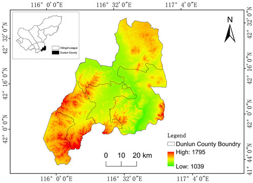
Figure 1. Location map of the study area.
2.2 Data sources
In this paper, remote sensing images and DEM data are derived from geospatial data cloud (http://www.gscloud.cn/) The meteorological data is from the official website of the National Meteorological Data Center (https://data.cma.cn/) The soil data is from the Geographical remote sensing ecological network (http://www.gisrs.cn/). Using remote sensing images, DEM data and arcgis10.8 software from 2000 to 2020, the slope, topographic relief, annual average temperature and the distance from the main water areas are obtained. Use ENVI 5.3 software to obtain vegetation coverage.
3 Research methodology
3.1 Identification and delimitation of PLES
PLES is a complex multi-functional complex. Its delimitation and classification should follow scientific principles and legal basis (Song et al., 2024). The land administration law of the people’s Republic of China clearly stipulates that the rational use and protection of land resources should be achieved through the scientific delimitation of permanent basic farmland protection red line and ecological protection red line (Li et al., 2024). Based on this, this paper constructs the classification system of PLES with the principle of keeping the permanent basic farmland red line and ecological red line, and guided by the land use function. In the process of classification, not only the main functions of land use are fully considered, but also the secondary functions are taken into account, so as to ensure full connection with the standards such as the general plan for land use, the classification of land use status (GB/t 21010–2007), the classification of urban planning land (GB 50137–2011), and the national ecological protection red line - Technical Guide for the delimitation of ecological function red line (Trial) (Liu, 2017). At the same time, referring to the identification and classification methods of liujilai and other scholars, combined with the current situation of land use in Duolun County, and taking the dominant function of land as the criterion, the land space is divided into three categories: production space, living space and ecological space (Table 1).
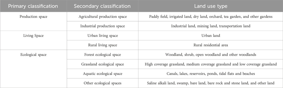
Table 1. PLES delimitation.
3.2 Construction of evaluation index system
The Analytic Hierarchy Process (AHP) is an important method for multi-objective decision-making proposed by Saaty (2001). According to the Analytic Hierarchy Process, the problem to be solved is divided into three levels: the goal layer (A), the criterion layer (B), and the alternative layer (C) (Saaty, 2008). This study, based on the specific characteristics of the research area, considers factors such as evaluation objectives, evaluation content, and evaluation scale. Administrative villages are selected as the basic units for the suitability evaluation, which is structured into three hierarchical levels: the target layer, the criterion layer, and the indicator layer. The study employs a research methodology integrating the Analytic Hierarchy Process (AHP) and the Delphi Method to construct the judgment matrix. A panel of 20 experts specializing in land resource management, urban and rural planning, and landscape ecology was invited to systematically assess the relative importance of various evaluation factors. The expert ratings were subjected to a consistency check using the Yaahp software platform (version 10.3) to ensure reliability. Based on the verified results, the weight values of each indicator were calculated, establishing the suitability evaluation system for the three-function spatial zones in Duolun County, as presented in Table 2.
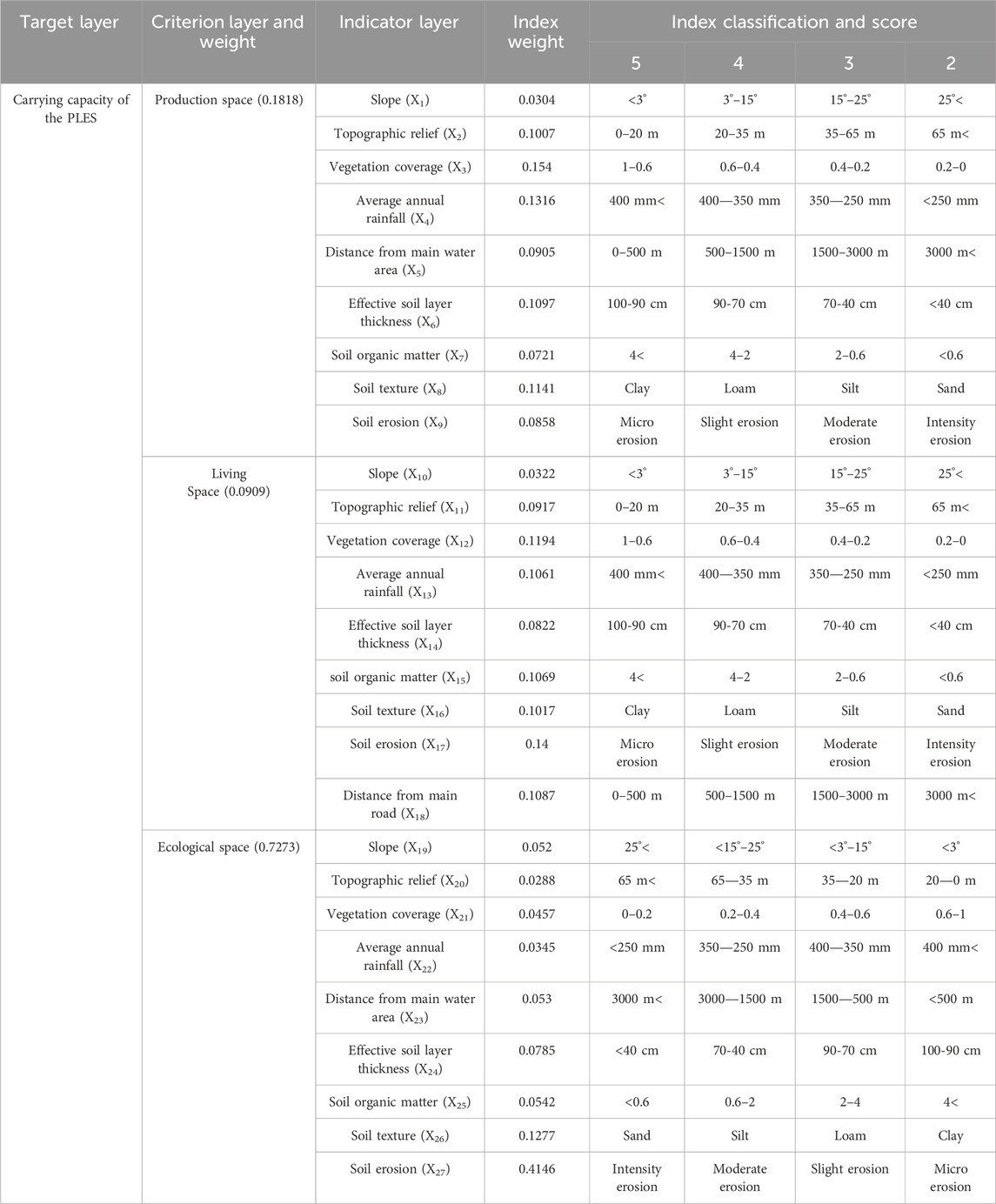
Table 2. Suitability evaluation index system and its weight of PLES space development.
3.3 Graded assignment
Using the Delphi method (Toumbourou, 2020) and the hierarchical assignment method (Cengiz and Akbulak, 2009), and in accordance with the geographical location and natural environmental conditions of the research area, starting from several key factors such as slope, topographic relief, vegetation coverage, average annual rainfall, distance from the main water bodies, effective soil layer thickness, soil organic matter, soil texture, soil erosion, and distance from the main roads, score, screen, and determine the cultivated land suitability evaluation factors. Based on the alternative factors, conduct Delphi expert scoring and calculate the weights to obtain a suitable factor system. Then, divide the assignment of various evaluation indicators into four levels, with the values assigned as 5, 4, 3, and 2 respectively (Table 2).
3.4 Determine indicator weight
First, the Analytic Hierarchy Process (AHP) (Toumbourou, 2020) is employed. Specifically, the problem is disassembled into multiple levels and factors. Subsequently, experts conduct pairwise comparisons of the importance of each factor, gradually establishing a judgment matrix. Based on this, the maximum eigenvalue and eigenvector are calculated, and the consistency index of the judgment matrix is computed and a consistency test is carried out. After completing all the tests, the final decision result is obtained through the overall hierarchical ranking (Rabiul Islam et al., 2024).
tIn the formula:
In the formula: CI is the consistency index of the judgment matrix. The closer CI is to 0, the better the consistency is, and the larger CI is, the worse the consistency is. RI is the average random consistency index. If CR < 0.1, it is considered that the judgment matrix passes the consistency test. Otherwise, the judgment matrix needs to be adjusted according to the actual situation until it meets the standard so that the results can continue to be verified (Panchal and Shrivastava et al., 2022).
In this research, the weights of three subsystems, namely, production space, living space, and ecological space at the criterion layer, as well as the index weights of the index layer of production space, living space, and ecological space, have been calculated, and all the results have passed the consistency test (CR < 0.1). By using ArcGIS 10.8 software, the expert assignment data of various evaluation indicators of the production space is opened. Then, the weighted sum tool of ArcGIS 10.8 software and the index weights of the production space are utilized to acquire the suitability data of the production space from 2000 to 2020. Using the same method, the suitability data of the living space and ecological space from 2000 to 2020 are obtained.
3.5 Suitability classification
Using Excel software and the suitability evaluation results of PLES, and Using ArcGIS10.8 natural breakpoint classification method, the suitability evaluation results of PLES from 2000 to 2020 are divided into four levels: high suitability area, higher suitability area, lower suitability area and low suitability area (Figures 2–5). The formula for calculating the suitability value is:
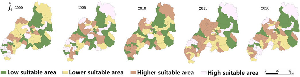
Figure 2. Spatio temporal distribution map of production space suitability.
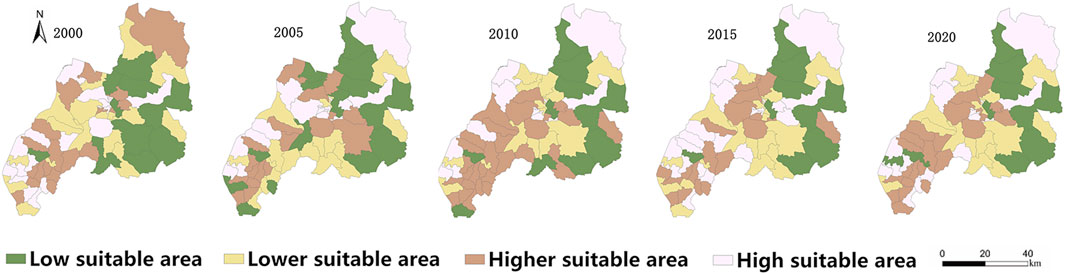
Figure 3. Spatio temporal distribution map of living space suitability.
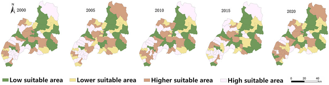
Figure 4. Spatio temporal distribution map of ecological space suitability.
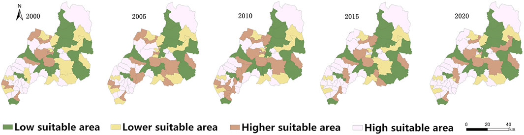
Figure 5. Distribution map of PLES carrying capacity in Duolun County.
In the formula: f(x) represents the suitability value of each criterion layer;
4 Results
4.1 Spatiotemporal evolution characteristics of PLES suitability
4.1.1 Suitability change of production space
As depicted in Figure 1, the changes in production space suitability in Duolun County from 2000 to 2020 profoundly reflect the optimization process of land use structure in China’s northern agro-pastoral ecotone under national spatial planning policy guidance. Data indicates that the county’s production space underwent a transition from low-suitability area dominance to an increased proportion of high-suitability areas, with the average suitability index exhibiting a “V-shaped” pattern, first decreasing then increasing. This transformation can be divided into two phases: First, the 2000–2005 suitability structure adjustment period, when under the influence of the “Returning Farmland to Forest Regulation” (2002) and the “National Ecological Environmental Protection Outline” (2000), the lower-suitability areas decreased significantly from 1,578.98 km2 (40.9%), while the proportion of high-suitability areas increased to 30.7%. The average suitability index declined from 4.398 to 3.967, with the production space centroid shifting 0.169 km northeast, reflecting the initial constraints of ecological policies on production land. Second, the 2005–2020 suitability optimization and enhancement period, when with the implementation of the “Land Use Master Plan” and the “Xilingol League Grassland Ecological Protection and Construction Plan,” the higher-suitability areas reached 35.0% (1,351.79 km2) in 2010, with significant improvements in the central and western regions of the county. The average suitability index recovered to 4.495, with the centroid shifting 0.320 km southwest (Table 3). This evolutionary process exhibits three core characteristics: spatial structure optimization—substantial reduction in lower-suitability areas, conforming to the “inefficient land reduction” requirement in the “National Land Spatial Planning”; functional layout adjustment—notable improvement in the suitability of central and western county areas, consistent with the “Township and Village Layout Planning” direction; and policy guidance effectiveness—the suitability index pattern reflects the policy shift from ecological protection priority to coordinated ecological and production development. From a regulatory framework perspective, the optimization of Duolun County’s production space results from the combined effects of multiple policies including the “Land Management Law,” “Basic Farmland Protection Regulations,” and “Inner Mongolia Autonomous Region Grassland Protection Regulations,” demonstrating the evolution of national spatial governance concepts for agro-pastoral ecotones.
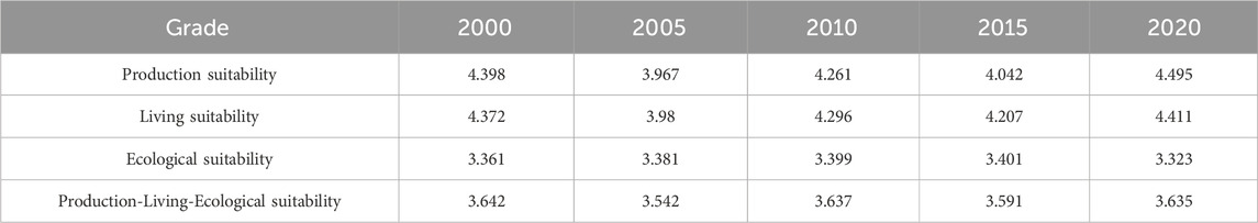
Table 3. Changes in the suitability index of PLES.
According to the “National Land Spatial Development and Protection 14th Five-Year Plan” and the “Inner Mongolia Autonomous Region Land Spatial Planning” (2021–2035), future optimization of production space suitability in Duolun County should continue to promote ecologically friendly production methods to achieve high-quality coordinated development of production, living, and ecological spaces. This regional case provides valuable reference for spatial planning practices in similar ecologically fragile areas in northern China, reflecting the significant enhancement of national spatial governance capabilities.
4.1.2 Suitability change of living space
As illustrated in Figure 3, from 2000 to 2020, the suitability of living spaces in Duolun County exhibited pronounced spatiotemporal heterogeneity, characterized by a general decline in low- and moderately low-suitability areas and an expansion of high-suitability zones, indicating a gradual improvement in regional habitability. In 2000, low- and moderately low-suitability areas were predominantly concentrated in the central region, accounting for 55.8% of the total land area, with the largest low-suitability zone (1,144.29 km2) located in the east. By 2005, the proportion of low- and moderately low-suitability areas decreased to 53%, yet the low-suitability area expanded further to 1,218.12 km2, suggesting a temporary decline in living space quality, likely due to extensive urban sprawl during early-stage urbanization or insufficient implementation of ecological conservation policies. A notable shift occurred in 2010, when high- and moderately high-suitability areas surged to 54% of the total area, with the latter becoming dominant (1,180.02 km2) and spatially reoriented toward the northern and southwestern regions—a change potentially linked to infrastructure upgrades or ecological migration initiatives. By 2015, high-suitability zones reached 51.11%, expanding from the southern core to central-northern and western areas, with the largest high-suitability area (1,202.96 km2) reflecting enhanced human settlement conditions. In 2020, low- and moderately low-suitability areas slightly rebounded to 51.4%, though the moderately low-suitability area (1,011.06 km2) remained below 2000 levels, indicating localized fluctuations possibly influenced by ecological constraints or regulatory adjustments.
Dynamically, the overall reduction in low- and moderately low-suitability areas and the steady growth of high-suitability zones from 2000 to 2020 were accompanied by a decline in the mean suitability index during 2000–2005, likely attributable to resource overexploitation or imbalanced coordination among production-living-ecological spaces (PLES). In contrast, the index showed a consistent annual increase (cumulatively 0.039%) from 2010 to 2020 (Table 3), underscoring the positive impact of later-stage spatial planning policies, such as the National Major Function-Oriented Zoning Plan and ecological redline mechanisms, on living space optimization. Furthermore, centroid shift analysis revealed that the living space centroid migrated 0.298 km northeastward during 2000–2005, possibly signaling intensified development pressure in eastern regions, while a 0.338 km southwestward shift from 2005 to 2020 aligned with western ecological restoration and compact urban planning strategies, consistent with national initiatives like the Western Development Strategy and New-Type Urbanization.
In conclusion, the evolution of living space suitability in Duolun County reflects the interplay of natural conditions, policy interventions, and development models: early-phase expansion of low-suitability areas exposed the drawbacks of extensive growth, whereas later-phase gains in high-suitability zones demonstrated the efficacy of ecological-priority spatial planning. Future efforts should further harmonize PLE space allocation, strengthen the synergy between living space development and ecological conservation, and ensure regional sustainable development.
4.1.3 Suitability change of ecological space
As manifested in Figure 4, from 2000 to 2020, the ecological space suitability of Duolun County underwent significant dynamic changes. Specifically, the areas of both highly suitable and low-suitability zones showed a general declining trend, while the areas of moderately high and moderately low suitability zones increased. These changes reflect adjustments in land use and ecological conservation patterns and were jointly influenced by natural environmental changes, policy regulations, and socio-economic development.
In 2000, highly and moderately highly suitable ecological zones were primarily distributed in the southwestern region, covering 55.2% of the total land area. The low-suitability zone was the largest, occupying 1,212.48 km2, or 31.4% of the total land area, mainly located in the northeastern region. By 2005, the highly and moderately highly suitable zones in the southwestern region further expanded, covering 61.4% of the total land, with the highly suitable area reaching 1,307.39 km2. During this period, the ecological suitability index declined, indicating a decrease in the ecological carrying capacity of the region.
In 2010, highly and moderately highly suitable zones remained concentrated in the southwestern region, occupying 56.7% of the total land area, while the low-suitability zone slightly decreased to 1,178.02 km2. However, by 2015, the spatial distribution changed: the area of highly and moderately highly suitable zones shrank to 48.3%, still mainly in the southwestern region, while the moderately low and low-suitability zones expanded toward the northeastern part of the county, reaching 51.7% of the total land area. This trend became more pronounced by 2020, when the proportion of highly and moderately highly suitable zones further declined to 31.4%, shifting from the southwestern region to the eastern and southern parts of the county. Meanwhile, the moderately low suitability zone became the largest, occupying 51.9% of the total land area, mainly in the northeastern region.
In terms of the ecological suitability index, it exhibited a declining trend between 2000 and 2005, indicating a deterioration in ecological conditions. However, from 2005 to 2020, the index showed a gradual increase, reflecting improvements in ecological suitability. Despite this upward trend, the overall index still declined by 0.038 compared to 2000, suggesting that although ecological conservation efforts have been strengthened, the quality of ecological space has not fully recovered to its original state (Table 3).
The spatial distribution of production and living spaces also changed, as analyzed through the center of gravity model. From 2000 to 2005, the center of gravity of the living space shifted southwest by 0.219 km. In contrast, between 2005 and 2020, the center of gravity of the production space moved northeast by 0.315 km. These shifts may have been influenced by changes in industrial structure, urbanization processes, and ecological conservation policies.
Several key factors contributed to the changes in ecological space suitability in Duolun County:
1. Implementation of national and regional ecological conservation policies–Projects such as the “Three-North Shelterbelt” program and the “Grain for Green” policy have improved ecological suitability in certain areas while simultaneously affecting the spatial distribution of production land.
2. Land use changes–Urban expansion and agricultural restructuring have led to the reduction of highly suitable ecological zones while increasing moderately low suitability areas.
3. Natural environmental factors–Climate change and variations in water resources have affected ecosystem stability and vegetation restoration capacity, influencing ecological suitability.
Overall, from 2000 to 2020, Duolun County experienced significant changes in ecological space suitability, with a reduction in highly suitable and low-suitability zones, while moderately high and moderately low suitability zones expanded. Although the ecological suitability index showed an increasing trend after 2005, it remained lower than in 2000. The spatial shifts in production and living spaces reflect the adjustments in ecological, urban, and economic structures. In the future, it is necessary to balance ecological conservation with production and living space optimization to promote coordinated and sustainable development of the ecological, economic, and social systems.
4.1.4 Suitability change of PLES
In this research endeavor, the functions of production space, living space, and ecological space are accorded equal significance. Based on the results of the suitability evaluation of individual spaces, the comprehensive suitability index value of PLES was computed using the arithmetic mean method. Subsequently, the comprehensive suitability evaluation outcomes of PLES from 2000 to 2020 were categorized into four levels, namely, high suitability area, higher suitability area, low suitability area, and lower suitability area, by employing the ArcGIS 10.8 natural breakpoint classification technique.
As illustrated in Figure 5, the analysis of comprehensive suitability evolution of PLES in Duolun County from 2000 to 2020 reveals significant spatiotemporal differentiation characteristics, which align closely with China’s ecological protection policies and regional development strategies. Research demonstrates that the total area of low suitability zones (decreasing from 54.6% to 43.8%) and relatively low suitability zones (decreasing from 17.1% to 14.6%) has continuously contracted, while high suitability zones (increasing from 11.3% to 56.2%) and relatively high suitability zones have exhibited exponential growth, portraying an overall optimization pattern of “two decreases and two increases” in spatial suitability. This transformation validates the effective implementation of the “dual emphasis on farmland quality improvement and ecological restoration” strategy proposed in the National Land Consolidation Planning (2016-2020). By 2010, high and relatively high suitability zones further expanded to 2,123.11 km2, accounting for 55% of the total area, maintaining their aggregation characteristics in the southwestern region. The proportion of relatively low suitability zones decreased to 14.6%, with their spatial distribution center shifting eastward. In 2015, high and relatively high suitability zones experienced some contraction, declining to 1,946.98 km2 (50.4% of the total area), still concentrated in the southwestern region, while low and relatively low suitability zones increased to 49.6%, predominantly distributed in the northeastern region. By 2020, high and relatively high suitability zones significantly rebounded to 2,170.23 km2 (56.2%), maintaining their southwestern aggregation pattern, while low and relatively low suitability zones decreased to 43.8%, with their distribution pattern remaining primarily in the northeastern region.
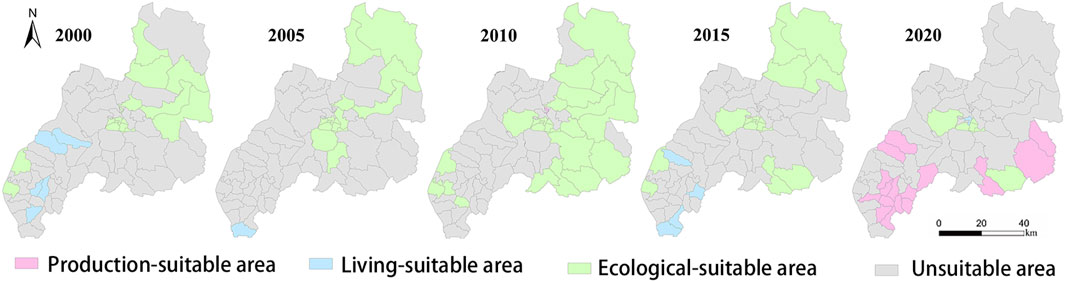
Figure 6. Spatial Distribution map of suitable land types in PLES.
Throughout the 2000-2020 research period, the comprehensive suitability of PLES in Duolun County exhibited spatial pattern evolution characterized by a gradual reduction in low and relatively low suitability zones, coupled with an overall increasing trend in high and relatively high suitability zones. It can be seen from Table 3, the comprehensive suitability index of PLES showed a declining trend during 2000-2005, followed by continuous growth during 2005-2020, though the overall suitability index slightly decreased (by 0.007) compared to the base period. Analysis using the gravity center migration model indicates that the suitability spatial center shifted 0.094 km southwestward during 2000-2005, while it migrated 0.12 km northeastward during 2005-2020, reflecting the dynamic fluctuation characteristics of regional production-living-ecological space suitability.
This spatiotemporal evolution pattern reveals that the suitability of PLES in Duolun County results from the combined effects of natural-social composite systems, exhibiting distinct regional differentiation and phased variation characteristics, thereby providing a scientific basis for future optimization and allocation of PLES in Duolun County.
4.2 Evolution characteristics of PLES conflict
This research thoroughly analyzes the evolutionary characteristics of PLES conflicts and systematically identifies three representative types of spatial conflicts: (1) Areas that are legally compliant but ecologically suboptimal, which meet current regulatory requirements but have not achieved ecological optimization from the perspective of ecosystem health and sustainable development; (2) Areas with resource competition between legal land uses, manifested as tensions in resource allocation among production, living, and ecological functions, which do not constitute regulatory violations but require coordination and balance at the policy level; (3) Potential ecological optimization areas, which have high ecological conservation value where strengthened protection would bring significant ecological benefits, but remain outside appropriate protection categories under the current regulatory framework.
Based on the suitability evaluation of production, living, and ecological land use, combined with ArcGIS10.8 spatial overlay analysis (Al-Najjar et al., 2024). we observed clear patterns in the spatiotemporal evolution of suitable land types in Duolun County: Between 2000–2015, suitable areas for the three types of land use were mainly distributed in the northeastern region of the county, while in 2020, they became concentrated in the piedmont plains and Luan River basin in the southern part of the county. The proportion of suitable areas experienced a “rise-fall” fluctuation process, increasing from 27.27% in 2000 to 54.2% in 2010, then decreasing to 24.9% in 2020. Among these, the ecological suitable area showed the most significant change, rising from 22.8% in 2000 to 54.2% in 2010, and then sharply declining to 6.1% in 2020. The proportion of living suitable areas remained consistently low and was mainly distributed in the southwestern part of the county. Production suitable areas were almost non-existent in 2000 and 2010, but developed to occupy 18.7% of the total area by 2020, primarily distributed in the sloping plains and Luan River basin in the southern part of the county. Overall, Duolun County has relatively small areas suitable for production and living land use, resulting in obvious conflicts in land resource competition.
This research does not focus on regulatory non-compliance issues, but rather explores the potential for spatial optimization within the existing legal framework. By scientifically identifying these three types of spatial conflicts, it provides decision-makers with scientific basis for optimizing spatial planning, aiming to promote coordinated development of intensive and efficient production space, moderately livable living space, and ecologically pristine space within the framework of production-living-ecological spaces. The research finds that the suitability pattern of the three spaces in Duolun County has undergone significant changes, with the substantial fluctuation of ecologically suitable areas being particularly noteworthy, reflecting the dynamic interplay between ecological protection and economic development in regional development processes. Future spatial planning should focus on balancing the proportional relationships among the three spaces, especially enhancing the intensive efficiency of production spaces, ensuring the livable quality of living spaces, and emphasizing the restoration and protection of the authenticity of ecological spaces. Through scientific planning and policy guidance, the strategic goal of regional sustainable development can be achieved.
5 Discussion
Duolun County in Inner Mongolia is situated at the southern periphery of the Hunshandake Sandy Land (Yi et al., 2023), constituting a paradigmatic farming-pastoral ecotone and an area highly susceptible to land desertification (Dai et al., 2024). Owing to the protracted influence of natural and anthropogenic factors, the incessant expansion of the land desertification area has exacerbated the deterioration of its ecological milieu. Concomitantly, the area of natural land suitable for utilization has been continuously contracting, while the area suitable for non-land use has been expanding. Since 2000, Duolun County has initiated a plethora of ecological projects, such as the treatment project of the Beijing-Tianjin sandstorm source area, ecological immigration, conversion of farmland to forest, prohibition of grazing and adoption of stall-feeding, afforestation of one million mu of Pinus sylvestris var. Mongolica, and the establishment of the Hunshandake large-scale forest farm (Dai et al., 2024). These initiatives have led to the remediation of a substantial expanse of desertified land, thereby resulting in a reduction of cultivated land, an augmentation of artificial grassland and other forest land with production functions, an increase in the area of suitable production land, and a significant diminution of the area of suitable ecological land, predominantly desertified land. This phenomenon is intricately correlated with the enhancement of vegetation coverage in Duolun County.
Under the aegis of the ecological immigration policy, the reduction of rural residential land area has concomitantly led to a decrease in the area of suitable living land (Liu X. et al., 2022). The comprehensive suitability of the three growth spaces has not exhibited an overt alteration, which is attributable to the paucity of production land and living land in Duolun County. Agriculture and animal husbandry constitute the preponderant industries in Duolun County. The progression of local agriculture and animal husbandry has augmented the demand for the utilization of land space, thereby intensifying the conflict among the three types of land uses and precipitating an annual increment in the area of the conflict zone.
Based on the developmental requisites of ecological, living, and production spaces, this study, from the vantage point of the PLES, constructed a suitability evaluation index system for PLES in Duolun County, Inner Mongolia. Subsequently, an in-depth analysis was conducted regarding the suitability of PLES development within the district. The resultant findings can serve as a valuable reference for the optimal configuration of land space.
Due to the limitations of time and data acquisition, the changes of the suitability of the Sansheng space from 2020 to 2024 are not considered, but Duolun county is located in the temperate continental climate zone, and its natural environment and socio-economic factors have changed little in recent years. Therefore, the results of this paper can provide a scientific basis for the optimization and management of land space in Duolun region. In the follow-up study, we can focus on the further improvement of the evaluation index system to make up for the deficiencies of the current research.
6 Conclusion
(1) During the period from 2000 to 2020, the production space in the southwest exhibited a higher degree of suitability in comparison to that in the northeast. Concurrently, its average suitability index manifested a mildly ascending propensity. The center of gravity of production space suitability underwent a translocation of 0.151 km towards the southwest, which could potentially be attributed to a confluence of factors such as differential land endowments, patterns of resource allocation, and the impact of anthropogenic activities on the spatial configuration of production-related land uses.
(2) Over the same temporal span from 2000 to 2020, the living space in the southwest also demonstrated a superior level of suitability relative to the northeast. Its average suitability index likewise evinced a feeble upward trend. The center of gravity of living space suitability migrated 0.04 km in the southwesterly direction. This shift might be ascribed to alterations in demographic distributions, urban-rural development dynamics, and the evolving preferences and requirements of the populace regarding living environments and associated land uses.
(3) The ecological spatial suitability was more pronounced in the southwest than in the northeast. However, its average suitability index exhibited a marginally descending trajectory. The center of gravity of ecological spatial function displaced 0.096 km towards the northeast. Such a displacement could be the result of complex ecological processes, including but not limited to changes in vegetation cover, soil quality degradation or improvement in different regions, and the influence of climate change on ecological habitats and their spatial distributions.
(4) The comprehensive suitability of PLES was preponderantly higher in the southwest and relatively lower in the northeast. Its average suitability index displayed a slight downward inclination. The comprehensive suitability center of PLES shifted 0.026 km towards the northeast. This overall trend implies a complex interplay of the three major spatial components - production, living, and ecological - and reflects the challenges and opportunities in achieving a balanced and sustainable spatial development paradigm.
(5) The areas suitable for ecological land use were principally concentrated in the central and southern precincts of the county, and they occupied the largest proportion of the total suitable areas. Notably, the area of the intense conflict zone, which might arise from competing demands between different land use functions, has been progressively expanding year by year. These conflict areas were mainly distributed in the central and western regions of the county, signifying the need for more refined land use planning and management strategies to reconcile the diverse and often conflicting interests and requirements of various stakeholders and ecological imperatives.
Data availability statement
The original contributions presented in the study are included in the article/supplementary material, further inquiries can be directed to the corresponding author.
Author contributions
DL: Conceptualization, Data curation, Formal Analysis, Funding acquisition, Methodology, Writing – original draft, Writing – review and editing. A: Conceptualization, Data curation, Formal Analysis, Funding acquisition, Supervision, Validation, Visualization, Writing – original draft, Writing – review and editing, Methodology, Investigation, Project administration, Resources. SN: Conceptualization, Data curation, Writing – review and editing.
Funding
The author(s) declare that financial support was received for the research and/or publication of this article. This research was funded by Natural Science Foundation of Inner Mongolia Autonomous Region (Grant No. 2020MS04012); And Key Laboratory of State Forest Administration for Desert Ecosystem Protection and Restoration.
Conflict of interest
The authors declare that the research was conducted in the absence of any commercial or financial relationships that could be construed as a potential conflict of interest.
Generative AI statement
The authors declare that no Generative AI was used in the creation of this manuscript.
Publisher’s note
All claims expressed in this article are solely those of the authors and do not necessarily represent those of their affiliated organizations, or those of the publisher, the editors and the reviewers. Any product that may be evaluated in this article, or claim that may be made by its manufacturer, is not guaranteed or endorsed by the publisher.
References
Al-Najjar, H., Zhang, W., Yirsaw, E., Nega, W., Zhang, Z., et al. (2024). Enhancing coffee agroforestry systems suitability using geospatial analysis and sentinel satellite data in gedeo zone, Ethiopia. Sensors 24, 6287. doi:10.3390/s24196287
Bhullar, A., Nadeem, K., and Ali, R. A. (2023). Simultaneous multi-crop land suitability prediction from remote sensing data using semi-supervised learning. Sci. Rep. 13 (1), 6823. doi:10.1038/s41598-023-33840-6
Bu, Z., Fu, J., Jiang, D., and Lin, G. (2023). Production–living–ecological spatial function identification and pattern analysis based on Multi-Source geographic data and machine learning. Land 12 (11), 2029. doi:10.3390/land12112029
Cengiz, T., and Akbulak, C. (2009). Application of analytical hierarchy process and geographic information systems in land-use suitability evaluation: a case study of Dümrek village (Çanakkale, Turkey). Int. J. Sustain. Dev. and World Ecol. 16 (4), 286–294. doi:10.1080/13504500903106634
Chen, Y., Zheng, B., and Liu, R. (2022). The evolution of ecological space in an urban agglomeration based on a suitability evaluation and cellular automata simulation. Sustainability 14 (12), 7455. doi:10.3390/su14127455
Cheng, J., et al. (2013). Spatial conflict and governance mechanism in ecologically fragile ethnic areas in our country:a case study of Gannan Tibetan Autonomous Prefecture of Gansu Province. Shanghai: East China Normal University.
Dai, L., Tang, H., Pan, Y., and Zhang, L. (2024). Assessment of ecosystem stability in the agro-pastoral transitional zone for local sustainable management: a case study in Duolun County, northern China. Ecol. Indic. 162, 112018. doi:10.1016/j.ecolind.2024.112018
Hopkins, L. D. (1977). Methods for generating land suitability maps: a comparative evaluation. J. Am. Inst. planners 43 (4), 386–400. doi:10.1080/01944367708977903
Ismaili, M., Krimissa, S., Namous, M., Htitiou, A., Abdelrahman, K., Fnais, M. S., et al. (2023). Assessment of soil suitability using machine learning in arid and semi-arid regions. Agronomy 13 (1), 165. doi:10.3390/agronomy13010165
Kalichkin, V. K., Pavlova, A. I., and Logachova, O. M. (2021). GIS-based multi-criteria analysis of the suitability of Western Siberian forest-steppe lands. Ann. GIS 27 (2), 225–237. doi:10.1080/19475683.2020.1848920
Li, C., Yang, H., Wang, Z., and Yan, S. (2024). Evaluating the implementation of ecological control line planning (ECLP): a case study of wuhan metropolitan development zone. Land 13 (7), 926. doi:10.3390/land13070926
Li, Y., Zhao, J., Zhang, S., Zhang, G., and Zhou, L. (2023). Qualitative-quantitative identification and functional zoning analysis of production-living-ecological space: a case study of urban agglomeration in central Yunnan, China. Environ. Monit. Assess. 195 (10), 1163. doi:10.1007/s10661-023-11716-6
Liu, J. (2017). Classification, evaluation and spatial-temporal analysis of “production-living-ecological” space in China. Acta Geogr. Sin. 72 (07), 1290–1304. doi:10.11821/dlxb201707013
Liu, Q., Yang, D., and Cao, L. (2022). Evolution and prediction of the coupling coordination degree of production–living–ecological space based on land use dynamics in the Daqing River Basin, China. Sustainability 14 (17), 10864. doi:10.3390/su141710864
Liu, X., Long, L., Fucang, Q., Yonghong, L., Chen, J., and Fang, X. (2022). Ecological policies enhanced ecosystem services in the Hunshandak sandy land of China. Ecol. Indic. 144, 109450. doi:10.1016/j.ecolind.2022.109450
Luo, Z., Yuan, Y., Qi, S., and Xu, J. (2022). RETRACTED: evaluating the carrying capacity and spatial pattern matching of urban and rural construction land in a representative city of Middle China. Forests 13 (9), 1514. doi:10.3390/f13091514
Ma, Y., Xue, F., and Yang, Z. (2023). Coupling study on territory space suitability evaluation and construction land expansion simulation: a case study of Jiangxi province, China. Environ. Dev. Sustain. 25 (8), 8279–8298. doi:10.1007/s10668-022-02399-z
Mishra, A. P., Singh, S., Jani, M., Singh, K. A., Pande, C. B., and Varade, A. M. (2022). Assessment of water quality index using Analytic Hierarchy Process (AHP) and GIS: a case study of a struggling Asan River. Int. J. Environ. Anal. Chem. 104 (5), 1159–1171. doi:10.1080/03067319.2022.2032015
Panchal, S., and Shrivastava, A. K. (2022). Landslide hazard assessment using ana lytic hierarchy process (AHP): a case study of National High way 5 in India. Ain Shams Eng. J. 13 (13), 101626. doi:10.1016/j.asej.2021.10.021
Rabiul Islam, M. D., Tareq Aziz, M. D., Kaderet, Z., and Islam, M. R. (2024). Site suitability assessment for solar power plants in Bangladesh: a GIS-based analytical hierarchy process (AHP) and multi-criteria decision analysis (MCDA) approach. Renew. Energy 220, 119595. doi:10.1016/j.renene.2023.119595
Ramya, S., and Devadas, V. (2019). Integration of GIS, AHP and TOPSIS in evaluating suitable locations for industrial development: a case of Tehri Garhwal district, Uttarakhand, India. J. Clean. Prod. 238, 117872. doi:10.1016/j.jclepro.2019.117872
Saaty, T. L. (2001). Fundamentals of the analytic hierarchy process. The analytic hierarchy process in natural resource and environmental decision making. Dordrecht, Netherlands: Springer. 10, 978–94.
Saaty, T. L. (2008). Decision making with the analytic hierarchy process. Int. J. Serv. Sci. 1, 83. doi:10.1504/ijssci.2008.017590
Shangshang, S., Dan, Y., and Xiaojie, L. (2024). Achieving coordinated development of multi-functional urban agriculture in Xiamen, China. Sustain. Cities Soc. 101, 105070. doi:10.1016/j.scs.2023.105070
Shi, M., Wu, J., Yang, N., Zhang, C., and Yi, X. (2023). Spatio-temporal patterns and driving forces of desertification in otindag sandy land, inner Mongolia, China, in recent 30 years. Remote Sens. 15, 279. doi:10.3390/rs15010279
Song, W., Cao, S., Du, M., and He, Z. (2024). Aligning territorial spatial planning with sustainable development goals: a comprehensive analysis of production, living, and ecological spaces in China. Ecol. Indic. 160, 111816. doi:10.1016/j.ecolind.2024.111816
Tang, H., Pan, Y., and Liang, D. (2022). Enhancing ecosystem services in the agro-pastoral transitional zone based on local sustainable management: insights from Duolun county in northern China. Land 11, 805. doi:10.3390/land11060805
Toba, A.-L., Paudel, R., Lin, Y., Mendadhala, R. V., and Hartley, D. S. (2023). Integrated land suitability assessment for depots siting in a sustainable biomass supply chain. Sensors 23, 2421. doi:10.3390/s23052421
Toumbourou, T. (2020). Using a Delphi approach to identify the most efficacious interventions to improve Indonesia’s forest and land governance. Land Use Policy 99, 102768. doi:10.1016/j.landusepol.2017.05.017
Ullah, K. M., and Mansourian, A. (2016). Evaluation of land suitability for urban land-use planning: case study D haka City. Trans. GIS 20 (1), 20–37. doi:10.1111/tgis.12137
Wang, C., Li, Z., Chen, H., and Wang, M. (2023). Comprehensive evaluation of agricultural water resources’ carrying capacity in anhui province based on an improved TOPSIS model. Sustainability 15 (18), 13297. doi:10.3390/su151813297
Wang, J., Wei, X., Sun, S., Li, M., Shi, T., and Zhang, X. (2023). Assessment of carbon sequestration capacity of E. Ulmoides in Ruyang County and its ecological suitability zoning based on satellite images of GF-6. Sensors 23 (18), 789. doi:10.3390/s23187895
Wang, L., Zhou, S., and Ouyang, S. (2022). The spatial prediction and optimization of production-living-ecological space based on Markov–Plus model: a case study of yunnan province. Open Geosci. 14 (1), 481–493. doi:10.1515/geo-2022-0373
Wang, S., Zhang, Y., Fan, J., Haiyan, Z., and Fang, H. (2023). Comprehensive sustainability indicator for land resource-carrying capacity in a farming-pastoral region. Remote Sens. 15 (15), 3726. doi:10.3390/rs15153726
Xiao, Z., and Gu, R (2022). Spatio - temporal pattern and multi-scenario simulation of land use conflict:A case study of the Yangtze River delta urban agglomeration. Geogr. Res. 41 (5), 1311–1326. doi:10.11821/dlyj020210375
Xu, Z. (2018). Harmonizing conflicts of land multifunction in natural reserves-Qiangtang National Natural Reserve as an example. Sci. and Technol. Review 36 (7), 8–13. doi:10.3981/j.issn.1000-7857.2018.07.001
Yang, Y., Liu, H., and Tao, W. (2024). Spatiotemporal variation characteristics and driving force analysis of precipitation use efficiency at the North foot of yinshan mountain. Water 16, 99. doi:10.3390/w16010099
Yang, Z., Yang, D., Geng, J., and Tian, F. (2022). Evaluation of suitability and spatial distribution of rural settlements in the karst mountainous area of China. Land 11 (11), 2101. doi:10.3390/land11112101
Zhang, K., Wei, W., Yin, L., and Zhou, J. (2023). Spatial-temporal evolution characteristics and mechanism analysis of urban space in China’s three-river-source region: a land classification governance framework based on “Three Zone Space”. Land 12 (7), 1380. doi:10.3390/land12071380
Zhanjun, L., and Chengtai, D. (2009). Land resource conflicts and coordination in hilly area of Southwestern China: A case study of Jiangjin District, Chongqing. Res. Soil Water Conservation 16 (2), 239–244.
Zhao, Y., Chi, W., Kuang, W., Bao, Y., and Ding, G. (2020). Ecological and environmental consequences of ecological projects in the Beijing–Tianjin sand source region. Ecol. Indic. 112 (C), 106111. doi:10.1016/j.ecolind.2020.106111
Zhao, Y., Li, T., Li, J., and Song, M. (2022). Study of township construction land carrying capacity and spatial pattern matching in Loess Plateau Hilly and gully region: a case of Xifeng in China. Int. J. Environ. Res. Public Health 19 (23), 16316. doi:10.3390/ijerph192316316
Zhao, Z., Deng, X., Zhang, F., Zhihui, L., Shi, W., Sun, Z., et al. (2022). Scenario analysis of livestock carrying capacity risk in farmland from the perspective of planting and breeding balance in Northeast China. Land 11 (3), 362. doi:10.3390/land11030362
Zhu, H., Huajun, W., Rong, G., and Yongqiang, Z. (2023). Surface subsidence characteristics of mining panel layout configuration with multi-seam longwall mining. Processes 11, 1590. doi:10.3390/pr11061590
Zhu, J., Zhengyong, S., Cheng, L., and Song, L. (2023). Functional measurements, pattern evolution, and coupling characteristics of “production-living-ecological space” in the Yangtze Delta Region. Sustainability 15 (24), 16712. doi:10.3390/su152416712
Zhu, Y., Zhang, R., and Cui, J. (2022). Spatial differentiation and influencing factors in the ecological well-being performance of urban agglomerations in the middle reaches of the Yangtze River: a hierarchical perspective. Int. J. Environ. Res. Public Health 19 (19), 12867. doi:10.3390/ijerph191912867
Keywords: production-living-ecological space (PLES), suitability evaluation, Duolun county, Inner Mongolia, the analytic hierarchy process (AHP)
Citation: Liu D, Aruhan and Na S (2025) Research on the suitability of production, living and ecological space development in Duolun County, Inner Mongolia. Front. Environ. Sci. 13:1541978. doi: 10.3389/fenvs.2025.1541978
Received: 09 December 2024; Accepted: 24 March 2025;
Published: 16 April 2025.
Edited by:
Cunyi Yang, Sun Yat-Sen University, ChinaReviewed by:
Svitlana Delehan, Uzhhorod National University, UkraineI Gusti Ngurah Parikesit Widiatedja, Udayana University, Indonesia
Copyright © 2025 Liu, Aruhan and Na. This is an open-access article distributed under the terms of the Creative Commons Attribution License (CC BY). The use, distribution or reproduction in other forums is permitted, provided the original author(s) and the copyright owner(s) are credited and that the original publication in this journal is cited, in accordance with accepted academic practice. No use, distribution or reproduction is permitted which does not comply with these terms.
*Correspondence: Aruhan, YXJ1aGFuQGltYXUuZWR1LmNu