 Baoling Dong
 Xiaowei Guo2
- 1School of International Tourism and Culture, Guizhou Normal University, Guiyang, Guizhou, China
- 2Academy of Arts, GuiZhou University of Finance and Economics, Guiyang, Guizhou, China
- 3School of Geography and Tourism, Shaanxi Normal University, Xi’an, Shaanxi, China
Based on the analysis of tourists’ digital footprints from 2018 to 2022, this paper examines the desert tourism in the Upper Reaches of the Yellow River in Ningxia, China. By combining social network analysis and ArcGIS methods, it visually presents the spatial network structure characteristics of tourism flow in Ningxia’s desert destinations in recent years. The results indicate that (1) the high rate of visitors in Ningxia is closely related to the grade value of the scenic spots and the popularity of cities, and the most popular scenic spots are concentrated in the Ningxia section of the Yellow River Basin. (2) Hot desert scenic spots with historical, cultural, and urban development characteristics have greater advantages and competitiveness; these spots can better connect with less popular tourism nodes and serve as breakthrough points for the rational allocation of tourism resources. (3) The tourism flow network among scenic spots in Ningxia is relatively loose, with an imbalance in the tourism network among these spots. (4) The spatial tourism flow presents a pattern of superposition and coincidence of multiple triangular structures. Among them, Zhongwei, Yinchuan, and Shizuishan are more attractive to tourists than Wuzhong and Guyuan.
1 Introduction
In China’s past, the desert was once synonymous with ecological threats, endangering the natural ecological environment and posing challenges to human survival and development. People living in desert areas have suffered from the invasion of the desert for many years, and their survival and development once lagged behind that of the areas with superior natural ecological environments. With the continuous and in-depth advancement of the desert ecological restoration project, the natural ecological environment in the core and edge areas of the desert has been improved, and the living conditions have also been greatly improved. With advances in environmental management technology, deserts, once known for dust storms and lack of drinking water for people and animals, have gradually become magnificent natural landscapes and popular tourist destinations. People’s understanding and utilization of the desert are constantly changing. The functions of the desert have been redefined, with the most significant transformation being the rise of desert tourism. Desert tourism destinations, desert tourism products, desert scenic spots, and desert tourism routes have been favored by an increasing number of tourists and have gradually become an important growth pole to promote the economic and social development of relevant regions.
In the new century, desert tourism has become a new form of tourism, following cultural tourism, ecotourism, ocean tourism, and adventure tourism (Carnicelli-Filho et al., 2010). Together with mountaineering tourism (Pomfret, 2006), drifting tourism, cave tourism, ice and snow tourism, and polar tourism, desert tourism has been listed as one of the six major styles of adventure tourism. The unique natural landscape, historical and cultural relics of the desert, and the optimization of the desert ecological environment not only provide tourists with different visual feelings and imagination space to find the human footprint in the desert but also create a natural space suitable for living, traveling, and releasing vitality. The boundless desert, the undulating sand dunes, the magical whistling sand beach, the dromedaries in groups, the sunrise and sunset in the sea of sand, the vast and lonely starry sky, and other unique desert landscapes and destinations are attracting tourists from all over the world to visit and meeting people’s demand for novelty, beauty, and exploration.
Sandy deserts are found on all continents except Europe and Antarctica. The geographical range of deserts is mainly located on both sides of the Tropic of Cancer (between 15° and 30° north and south latitudes) and in the mid-latitudes of the Eurasian continent in the northern hemisphere (between 35° and 50° north latitude). China is one of the countries in the world with a wide distribution of deserts, which are mainly concentrated in the arid and semi-arid zones in the northwest, such as Xinjiang, Inner Mongolia, Gansu, Ningxia, Qinghai, and other places. In recent years, as the effectiveness of China’s desertification control has become increasingly significant, the deserts and sandy areas that used to be uninhabited are now showing a new scene of booming industries and tourists. At present, there are more than 100 desert tourist attractions in China, covering 8 deserts and 4 sandy lands, and they are mainly distributed in Xinjiang, Gansu, Qinghai, Ningxia, Inner Mongolia, Shaanxi, Hebei, and other places, showing a strip layout extending from west to east. Among them, the earliest desert scenic spot in China is Crescent Lake in Dunhuang, which developed in the middle of the last century. In 1986, Wuwei Desert Park in Gansu Province became China’s first tourist park combining desert scenery with an oasis. In 1994, Shapotou Nature Reserve in Ningxia became the first national desert nature reserve in China. With the restoration of ecological environment and the development of scenic spots, China’s desert tourism products and destinations are becoming increasingly diverse and gaining widespread recognition.
With the rapid l growth of desert tourism products and well-developed desert tourism routes, the Shapotou Tourism Resort in Ningxia has become a renowned model of desert tourism in Western China, gaining recognition at home and abroad. The planning and construction of the Ningxia desert tourist destination not only has a great impact on the choice of tourist destination and spatial flow mode but also has a great impact on the economic and social development of the destination in Ningxia. However, the existing studies on desert tourism in Ningxia lag behind the speed of its development, which is not beneficial to the analysis of the development trend of desert tourism. Therefore, this study takes Ningxia Hui Autonomous Region, China, as an example, gathers online travel notes published by tourists on major websites as data samples, and analyzes the network spatial structure of Ningxia tourism flow and tourists’ preferences to analyze the development status and trend of regional tourism and expand the perspective of desert tourism research.
2 Literature review
2.1 Desert tourism
The desert is an important tourism resource and tourism attractions. The vastness of the desert provides a huge space for the development of tourism activities. Desert tourism includes not only desert tourism products and scenic spots but also experiences such as desert sightseeing, vacation and leisure, and adventure tourism. Based on the study area, desert tourism case sites are mainly well-developed and popular desert scenic spots, tourism destinations, cities, national parks, and world heritage sites. Examples include the Painted Desert and Grand Canyon National Park (Cole et al., 2008); Death Valley National Park (Dorn and Day, 2025); the Mojave Desert and Sonoran Desert in Mexico; the Atacama Desert in South America (Bull et al., 2018); the Nazca Desert in southern Peru; the Sahara Desert in northern Africa (Gil-Sánchez et al., 2025); the Tozeur Desert tourist area in southern Tunisia; the pyramids, the Sphinx, and desert landscapes in Egypt; the famous Black and White Desert; the South African Desert National Parks; Dubai in the United Arab Emirates; Jordan’s Wadi Rum desert (Khater et al., 2025); Israel’s Negev Desert (Margulis and Rosen, 2025); the Karakum Desert in Central Asia; the Great Indian Desert in northwest South Asia (Saeed et al., 2024); Australia’s deserts, including the Great Sandy Desert, Victoria Desert, Gibson Desert, and Simpson Desert; and the famous Uluru-Kata Tjuta National Park, a major desert tourism destination. These locations are key research areas for desert tourism worldwide.
In terms of the development value of desert tourism and the promotion of regional sustainable development, Narayanan and Macbeth (2009) regard desert tourism as a type of pilgrimage tourism and believe that the desert is both an internal space for isolation and purification of the soul and an external space for pilgrims, adventurers, and travelers to visit and reside in, and the mysterious natural environment of the desert gives the desert a special spiritual significance and enriches the spirituality of the tourists. Mousazadeh et al. (2023) argue that qanats are an important cultural heritage landscape in the desert region, that qanat tourism in the desert region is a way to promote sustainable development in the region, and that the destination’s diversified desert tourism development plan, which combines cultural heritage and natural landscape, contributes to the sustainable development of the region.
In terms of the impacts of desert tourism on environmental justice, social equity, and the interests of multiple actors, Schmidt and Uriely (2019) examined the tourism development process in the Israeli desert town of Mitzpe Ramon over the past 60 years from the perspective of community-based tourism (CBT) and found that the local residents living in the core area of Mitzpe Ramon tended to participate in the development of the tourism industry and benefited from it, while the residents in the peripheral communities were indifferent to the development of the tourism industry. Schmidt et al.’s study of desert tourism focuses on the impact of the development of desert tourism on the improvement of living conditions and the change in relationships among community members.
In terms of industry development extension, product diversification, and environmental safety of the destination, (Reichel and Uriely, 2003) focused on the impacts of the desert tourism product portfolio of sandy beaches, deserts, and typical shopping items of the world tourist destination Dubai on the economic and social development of the local community. Torabi (2024) studied how farmers near Iran's Tulan Park sustain their livelihoods by selling agricultural products to tourists. Sutton (2016) used a series of tourism festivals as a case study to analyze the impact of the diversified marketing strategies of Dubai, a world-class tourist destination located in a desert region, on destination branding, brand extension, and brand cooperation on destination promotion and marketing. Santarém and Paiva (2015) found that developing desert ecotourism in arid areas is an effective way to alleviate poverty, but desert ecotourism is often neglected by the government due to the large investment capital and slow results, so the investment of funds for desert ecotourism management should be emphasized by the relevant departments.
Although researchers have studied the development of the desert tourism industry and desert tourism destinations from different perspectives, they have relatively neglected the tourism flow, tourism market, and hot and cold scenic spots of desert tourism destinations, which is not conducive to analyzing the future development trend of desert tourism destinations in a more comprehensive way. Taking tourism flow as the starting point of desert tourism analysis can make up for the shortcomings of desert tourism marketing analysis and also help further improve the comprehensive understanding of desert tourism destinations.
2.2 Tourism flow
Tourism flow is the projection of tourist itineraries and tourism activities in a geographical space (Kádár and Gede, 2021). It has the geographical concept of tourism spatial attribute (Leiper, 1989); specifically, it refers to the number and flow mode of tourists flowing from the original location to the destination, which is called O–D research in geography. It consists of three basic elements, namely, direction, rate, and link mode (Bowden, 2003). Some scholars try to understand the complexity and dynamics of tourism flow between different destinations and scenic spots (Ruiz-Ortega et al., 2021) so that tourism destinations can carry out tourism planning and management more effectively. Other scholars have learned about cold and hot spots through the analysis of the spatial network structure of tourism flow (Gidebo, 2021) to analyze the influencing factors of the low visitor rate of cold spots and provide effective opinions and suggestions for improving the attraction and quality of scenic spots (Beritelli et al., 2020; Mou, et al., 2020). Among these scholars, Gunn was one of the first scholars to discuss the relationship and difference between the ‘destination trip’ and the ‘touring trip’ (Gunn and Var, 2020). Pearce (1987) was the first to study the spatial model of backpackers’ tourism.
In addition, many scholars have conducted several research studies on tourism flow from the dimensions of space and time (Chancellor and Cole, 2008), including the temporal and spatial patterns of tourism activities, tourist destination choice behavior and preference, forecasting of tourist volume and tourist trajectory driving force of the tourism destination choice (Lee and Kim, 2018), and influential factors of tourist flow and travel behavior (González-Pérez, 2019). As an interdisciplinary subject of geography and tourism, the study of tourism flow is not only helpful for researching tourists’ destination choice preferences and the influencing factors of tourism decision-making but is also helpful for understanding the cold and hot spots in a region to carry out scenic spot planning and development, which is advantageous to public infrastructure construction and sustainable development of tourism destinations.
Although researchers have studied the temporal and spatial distribution characteristics of tourism flow from different aspects such as rural tourism, urban tourism, and ecotourism, the research on the temporal and spatial distribution of tourism flow in desert tourism destinations is still relatively lacking, which is not beneficial for development in desert tourism destinations.
2.3 Tourist digital footprint
With the wide application of information technology and digital tools in the field of tourism, a large number of geospatial databases have been created to record the trajectory of tourism activities. These databases provide data support for studying tourism spatial network patterns in the modern geographic information age. The rapid development of the Internet in China has promoted the emergence of Qunar, Ctrip, and other large online travel agencies. They are not only powerful information interaction and tourism products’ marketing platforms but also media platforms for many users and tourists (Salas-Olmedo et al., 2018). These users not only provide information from non-tourism suppliers for other tourists but also accumulate massive and accurate tourism digital footprints for studying the spatial structure characteristics of destination tourism flow by sharing geo-tagged photos, publishing online travel notes, and sharing tourism itineraries and experiences on these online social media platforms.
In the digital age, texts and photos are the digital manifestations of the Internet. These digital forms contain a large amount of temporal and spatial information about tourists’ past tourism. Publishers share details about when and where they traveled, how many days they traveled, the places they visited, and numerous destination photos (Mou et al., 2020) By analyzing this data, researchers can understand tourists' destination selection preferences by exploring the digital footprint of their activities. Therefore, “digital footprints,” such as text and photos, provide a new perspective for studying tourists’ movement patterns and consumption behavior in real-world geographical spaces. Salas-Olmedo et al. (2018) considered that the “tourism digital footprint” is the relevant tourism information left on the network or other information systems after people use various communication devices and network media. As a way to reveal tourists’ time and spatial information, digital footprints can be used to analyze tourists’ choices and behaviors. Digital footprint photos were used to study the tourism situation of Florence and Rome. In Japan, Arreeras et al. (2019) used a Wi-Fi scanner device to track tourists’ traveling behavior in Hokkaido’s tourism area. In China, with the development of information technology and network media, the sources of tourism digital footprints are becoming increasingly richer. A large number of scholars began to use big data information, such as travel notes data of Ctrip and Mafengwo, check-in data of Sina micro-blog users, Lvmama ticket comment mobile operator data, etc., to build multi-scale tourism flow network temporal and spatial characteristics, with countries, regions, and cities as research objects, and it established a good methodological and empirical foundation for the research on the spatial network structure of tourism flow.
Although these studies are well-established, studies on the spatial structure characteristics of the tourism network in the western cities of Ningxia are relatively lacking, with little focus on the direction of tourism flow in the region. Therefore, this study takes Ningxia as an example to explore its spatial structure and characteristics of tourism flows, as a way to make up for the lack of attention paid to desert tourism cities in western China.
To sum up, the various phenomena in the development of desert tourism are essentially a social phenomenon composed of a multi-factor and multi-level complex system. In the tourism context, the interaction between tourists and tourism activities conveys all types of material and non-material flows. The interaction between these flows generates the spatial network structure of tourism flow. Understanding the spatial network structure of tourism flows can reveal ‘competitive and cooperative’ relationships between destinations but also serves as an index for evaluating regional tourism competitiveness. Therefore, based on the perspective of destination spatial relationships, this paper studies the spatial structure of the desert destination tourism route network in Ningxia, hoping to provide an empirical reference for the construction of destination infrastructure, transportation development, product development, scenic spot planning, and social environment management by understanding the spanning spatio-temporal footprint of tourists.
3 Research area overview, data, and methods
3.1 Research area overview
Ningxia Hui Autonomous Region, located in the northwest of China, is at the intersection of the eastern monsoon region, the northwest arid region, and the Qinghai Tibet Plateau. In Ningxia, the Helan Mountains stand in the northwest, Liupan Mountain lies in the southwest, and the Yellow River flows in from Zhongwei city in the west. Ningxia is also the smallest provincial-level region in China.
The total area of Ningxia is approximately 66,400 square kilometers, with the Tengger Desert being the most dominant desert region. The total desert and sandy area in Ningxia is approximately 12,600 square kilometers, accounting for approximately 19% of its total land area. The deserts and sandy areas are mainly distributed in the central and northern parts of Ningxia. Among them, Zhongwei city is the core area of desert distribution in Ningxia, especially the Shapotou area, which is located at the southeast edge of the Tengger Desert. There are some sandy areas in the eastern foothills of the Helan Mountains in the western part of Yinchuan city. There are also sandy areas in Yanchi County and other places in Wuzhong city. In addition, there are a small number of sandy areas in the northern part of Shizuishan city, which is close to Inner Mongolia. Tengger Desert is the fourth largest desert in China, spanning Ningxia, Inner Mongolia, and Gansu. The Tengger Desert in Ningxia, represented by Shapotou, features large, undulating sand dunes and magnificent landscapes; it serves as a model area for desert tourism and ecological management.
There are three reasons why we chose Ningxia as the case study area. First, Ningxia is a typical area of an optimized ecological environment; the region's natural geographic features of sand, water, mountains, and wood coexist, which gives the region a unique landscape advantage. This distinctive combination has earned Ningxia the nickname “Chinese Miniature Bonsai,” with its desert areas becoming great tourism resources. Through years of continuous development and construction, Shapotou in Ningxia has been created as a first-class desert tourism attraction; Ningxia is also known as the “sand capital of the world.” Second, Ningxia is the ancient capital of Xixia, an important node of the Silk Road, and the largest Hui Autonomous Region in China. Ningxia’s profound history, vibrant culture, and unique ethnic customs create a distinctive desert cultural charm, providing tourists diverse cultural experiences and a sense of mystery. Third, Zhongwei in Ningxia is famous at home and abroad for its ecological miracle and the wonder of “the bell ringing on the sand slope.” Ningxia was known as “the pearl of the Silk Road,” and the saying ‘go to Ningxia, give your heart a holiday’ shows its position as the main destination of desert tourism in Western China. By 2020, Ningxia had 96 national A-grade scenic spots, including 4 5A scenic spots and 92 4A scenic spots, as shown in Figure 1.
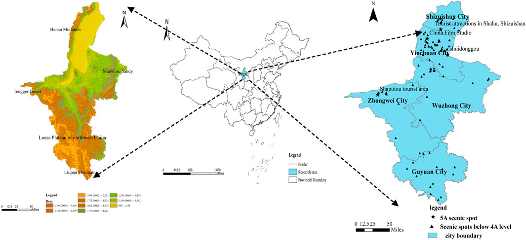
Figure 1. Research area location and spatial distribution of A-level scenic spots in Ningxia.
3.2 Data
In this study, Python technology was applied to obtain a total of 745 travelogues published on the three representative Chinese travel service platforms, namely, Mafengwo (https://www.mafengwo.cn), Qunar (https://www.qunar.com/), and TravelGo (https://www.travelgo.com/). The period of data collection was from January 2018 to December 2022. The study mainly included travel notes from well-known OTA websites in China, and since overseas tourists are less familiar with these platforms, there is little to no information on their travel experiences, leading to a lack of records on overseas tourists’ travel notes. A total of 745 travel notes were reviewed, of which 135 were excluded due to incomplete descriptions tourist attractions, unclear records of travel time and location, and inconsistencies between travel records and tourist destinations. This left 610 travel notes that met the research requirements for analyzing travel flow.
3.3 Methodology
This paper uses social network analysis with ArcGIS to analyze the spatial structure of the Ningxia tourism flow network (Figure 2) (Mou et al., 2020). First, an evaluation index system for the Ningxia tourism flow network structure is established and analyzed from two aspects, namely, tourism node structure and tourism network structure. The tourism node structure is composed of structural holes and centrality. The structural hole of the tourism node includes Freeman’s degree, closeness centrality, and Freeman betweenness centrality. The centrality of tourism node includes effsize, efficiency, and constraint. The tourism network structure includes network density, network centrality, core and periphery, and roles and positions (Asero et al., 2016), which mainly measures the structural attributes of the whole tourism network (Mou et al., 2020; Liu, 2009; Table 1).
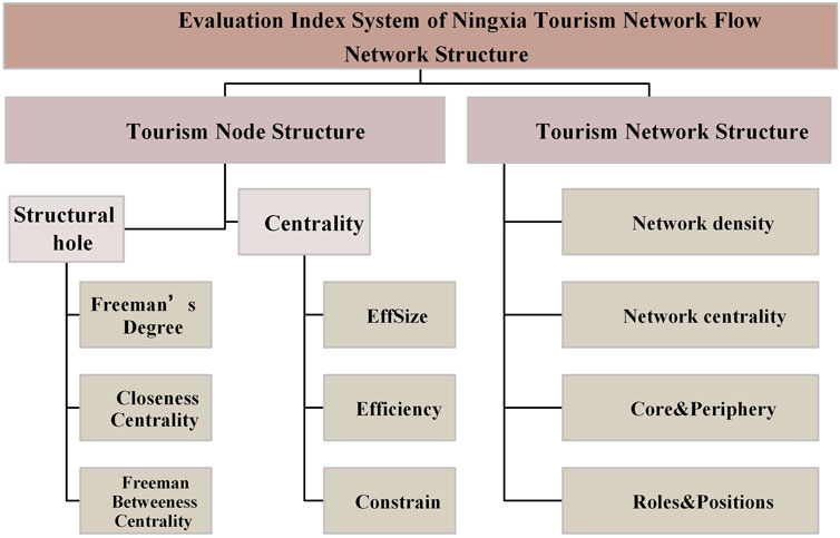
Figure 2. Evaluation index system of the Ningxia tourism flow network structure.
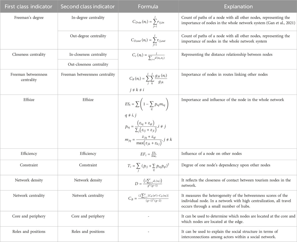
Table 1. Tourism node structure.
First, in terms of social network analysis, this paper transforms the text information into mathematical information, determines the network relationship of tourism flow, builds the data matrix Xij of tourist node flow direction, and establishes the assignment matrix. For example, according to the visiting sequence, the tourists’ itinerary is divided into directional node pairs, such as China Film Studio→Folk custom garden in Ningxia→Nanmen square, which can be split into China Film Studio→Folk custom garden in Ningxia and Folk custom garden in Ningxia→Nanmen square; if there is a direct flow between node pairs, it is recorded as 1; if not, it is recorded as 0, and it is stored in Excel in the form of a matrix.
Second, the matrix is imported into UCINET, the correct breakpoint value is selected, and the assignment matrix is transformed into a dichotomous matrix. Finally, according to the dichotomous matrix, the index values for individual tourism flow nodes and the whole network in Ningxia are calculated.
Finally, ArcGIS is used to visualize the spatial distribution of tourism resources in Ningxia to understand the spatial distribution as a whole.
4 Result and analysis
We collected a total of 745 travel notes from 2018 to 2022, from which we excluded 135 travel notes with incomplete information records and retained 610 travel notes that met the requirements. According to the order of tourists’ visits, the actual itinerary of tourists was divided into directed node pairs, which were stored in Excel in the form of a matrix. There were a total of 74 nodes relationship data units, resulting in a 74*74 multi-valued directed relationship matrix; furthermore, 2,687 pieces of information were extracted regarding the flow pattern between nodes.
4.1 Characteristics of tourism flow and network structure
We inserted the matrix in Excel into UCINET, and the spatial structure network diagram of Ningxia desert tourism flow was generated using NetDraw (Figure 3). According to Figure 3, the larger the area of the box, the greater the inflow and outflow of tourists in the scenic spot. The thicker the connecting line between nodes, the more frequent the tourist travel between them.
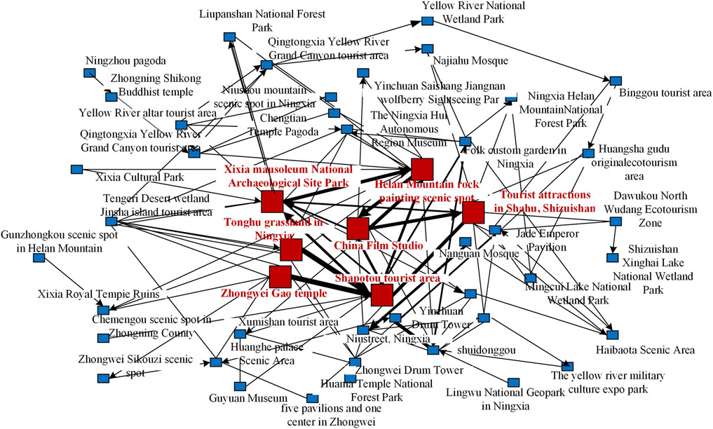
Figure 3. Structure of the tourism flow network in Ningxia.
As shown in Figure 3, there are seven scenic spots with large red boxes and close connections, namely, Helan Mountain rock painting scenic spot, Xixia Mausoleum National Archaeological Site Park, China Film Studio, Tonghu grassland in Ningxia, Shapotou tourist area, Shahu tourist area in Shizuishan, and Zhongwei Gao temple. All these seven nodes are located in the Ningxia section of the Yellow River Basin. These seven scenic spots have some common features.
First, they are not only historical and cultural relics derived from the desert but also symbols and image cards of Ningxia cities. Most of them are located in Yinchuan city, Zhongwei city, and Shizuishan city, where the economy of Ningxia is more developed. For example, Helan Mountain rock painting scenic spot, Xixia Mausoleum National Archaeological Site Park, and China Film Studio are located in Yinchuan city, the capital of Ningxia. Historically, Yinchuan was the seat of the Xixia Dynasty, so there are the royal mausoleums of the Xixia Dynasty and the rock paintings that are very rich in the regional characteristics of the northwest frontier. China Film Studio was the most popular film shooting base in China in the last century and served as an important filming location for “Journey to the West” and “The New Dragon Inn.” It enjoys high popularity and reputation, particularly among those interested in city tourism, historical and cultural tourism, and film tourism. Yinchuan city, as the capital city, has boasts abundant tourism resources, a rich historical heritage, modern urban infrastructure, and excellent transportation accessibility; therefore, these three attractions become the best choice for tourists.
Second, Zhongwei Gao temple is located in the Shapotou tourist area. Desert tourism popularity is also high in Zhongwei city, Shapotou tourist area, due to the rise in its popularity and influence of the show “Where Are We Going, Dad?.” which attracted a lot of family tourism and parent–child tourism groups to enjoy the desert scenery, leisure, and vacation. The Zhongwei Gao temple in downtown Zhongwei has become a must-visit place for tourists in Zhongwei due to its rich history and culture.
Third, since Ningxia is the smallest province in China, the improvement of its transportation infrastructure in recent years has gradually enhanced accessibility and interaction between cities. The driving distance from Yinchuan to Zhongwei city is approximately 2 h, and the driving distance from Yinchuan to Shizuishan city is approximately 1 h, so the Ningxia Tonghu Grassland, located in Shizuishan city, provides convenience for tourists. In addition, due to the advantage of the Yellow River flowing through Shizuishan and the effectiveness of China’s desertification control in recent years, the Ningxia Tonghu Grassland has become a typical example of the diversity of sandy and lake landscapes in arid and semi-arid regions. In summary, the core nodes are all high A-grade scenic spots located in highly popular cities in Ningxia, which bring the highest frequency of tourists, and it shows that the tourist reception rate in Ningxia is closely related to the grade value of the scenic spots and the high popularity of the cities.
4.2 Characteristics of the tourism node structure
4.2.1 Structural hole
This paper analyzes the structural hole of tourism flow network nodes in Ningxia through three indicators, namely, Freeman’s degree, closeness centrality, and Freeman betweenness centrality. Furthermore, this paper analyzes the advantages and disadvantages of each tourism node’s centrality in Ningxia through the effsize, efficiency, and constraint level of the structural hole index. After the generated matrix in Excel is inserted into UCINET for binarization, the node structure index values of the Ningxia desert destination tourism flow network are obtained (Table 2). Considering the limited space of the article, only the top 27 nodes’ index values are displayed.
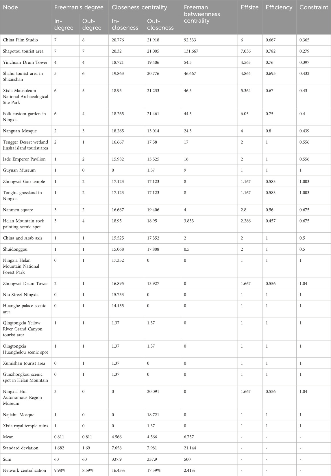
Table 2. Tourism nodes’ structure indicators (top 27).
Freeman’s degree can reflect the agglomeration and radiation ability of a tourism node compared with other tourism nodes. As provided in Table 2, the top six among the tourism nodes of Freeman’s degree are China Film Studio, Shapotou tourist area, Shahu tourist area in Shizuishan, Xixia Mausoleum National Archaeological Site Park, Folk custom garden in Ningxia, and Yinchuan Drum Tower. These six nodes are in the core position of Ningxia tourism and are the distribution nodes of Ningxia tourism. The six nodes have two characteristics. First, the six nodes are 5A scenic spots and famous historical and cultural attractions. Second, the six nodes are in the typical desert tourism destinations in Ningxia. It can be observed that desert scenic spots, historical and cultural relics derived from deserts, and urban development marks are the first choice for tourists to visit Ningxia. Among the six nodes, the out-degree of China Film Studio and Shizuishan Shahu tourist area is greater than the in-degree, which indicates that their outward diffusion effect is greater than their agglomeration effect. The in-degree of the Xixia Mausoleum National Archaeological Site Park and Folk Custom Garden in Ningxia is greater than the out-degree, which indicates that their agglomeration effect is greater than the diffusion effect. The lower ranking nodes, such as Xixia royal temple ruins, Najiahu mosque, Ningxia museum, Gunzhongkou scenic spot in the Helan Mountains, and the Xumishan tourist area, have lower Freeman’s degree, mainly because they are far away from the core scenic spots. The agglomeration and diffusion effects in the network are not obvious owing to the scattered distribution, which makes it difficult to connect with the core scenic spots to form a tourism route.
The closeness degree can be used to measure the closeness between a tourism node and other nodes. The higher the closeness degree is, the closer the tourism node is to other nodes, and vice versa. As observed from Table 2, on the whole, there are 18 nodes (e.g., China Film Studio, Shapotou tourist area, Yinchuan Drum Tower, Shahu tourist area in Shizuishan, Xixia Mausoleum National Archaeological Site Park, Ningxia Folk Custom Garden, Nanguan Mosque, Tengger Desert Wetland Jinsha Island tourist area, Jade Emperor Pavilion, Zhongwei Gao temple, Tonghu grassland in Ningxia, Nanmen Square, Helan Mountain rock painting scenic spot, China and Arab axis, Shuidonggou, Zhongwei Drum Tower, Qingtongxia Yellow River Grand Canyon tourist area, and Qingtongxia Huanghelou scenic spot), whose overall gap between the out-closeness value and the in-closeness value is small. This indicates that with high internal accessibility, the 18 nodes are mutual sources and destinations where most tourists tend to flow in.
The closeness of these nodes (e.g., China Film Studio, Shapotou tourist area, Yinchuan Drum Tower, Shahu tourist area in Shizuishan, Xixia mausoleum National Archaeological Site Park, Folk custom garden in Ningxia, and Nanguan Mosque) is particularly prominent and favored by tourists because of the high popularity, convenient transportation, and short distance travel routes. In addition, there are isolated points in the network with a large gap between the in- and out-closeness degree, such as Ningxia Helan Mountain National Forest Park, Niu Street Ningxia, Huanghe Palace scenic area, Xumishan tourist area, and Gunzhongkou scenic spot in Helan Mountains, which have a small value of out-closeness degree and a large value of in-closeness degree, and they are mostly at the edge of the network, which indicates that their accessibility is not high. Another example is the Ningxia Hui Autonomous Region Museum and Najiahu square, whose out-closeness degrees are large and in-closeness degrees are small, which indicates that these two nodes are less dependent on other nodes in the network and have little contact with other nodes, and tourists mainly carry out activities around these two nodes.
Freeman betweenness centrality measures the control ability of a node over other nodes. The higher the value of Freeman betweenness centrality, the stronger the control degree of the node over other nodes will be, and vice versa. As observed from Table 2, the result of the mean value of Freeman betweenness centrality is 6.757. Freeman’s betweenness centrality of the nodes (e.g., Shapotou tourist area, China Film Studio, Yinchuan Drum Tower, Shahu tourist area in Shizuishan, Xixia mausoleum National Archaeological Site Park, Folk custom garden in Ningxia, Nanguan Mosque, Tengger Desert Wetland Jinsha Island tourist area, Jade Emperor Pavilion, Guyuan Museum, Zhongwei Gao temple, and Tonghu grassland in Ningxia) is much greater than the mean value, which indicates that these 12 nodes have more connections with other nodes and are in the core position of tourism. Therefore, we need to fully consider the radiating and driving effects of these 12 nodes and leverage their core advantages to promote the collective development of other nodes. On the contrary, Freeman’s betweenness centrality of the remaining 62 nodes is lower than the mean value, indicating that the core status of the remaining 62 nodes is not strong and there are fewer interactions with the 12 nodes mentioned above. Therefore, these 62 scenic spots should fully understand the disadvantages of location, transportation, and tourism products and form a distinctive and different tourism product combination by strengthening the interaction with the core scenic spots and upgrading the quality of tourism products.
4.2.2 Centrality
The location of disconnection between nodes in the tourism flow network is called centrality. Centrality is mainly reflected by three indexes, namely, effsize, efficiency, and constraints, which can be used to identify the advantages and disadvantages of nodes in the network. The results in Table 2 show that the Shapotou tourist area has the most effsize, the highest efficiency, and the lowest constraints, which represents that the Shapotou tourist area has the most obvious advantages in the Ningxia tourism flow network and has more competitive opportunities and irreplaceability. In addition, the five nodes (e.g., Ningxia Folk Custom Garden , China Film Studio, Xixia Mausoleum National Archaeological Site Park, Shahu tourist area in Shizuishan, and Yinchuan Drum Tower in Ningxia) also have significant advantages and competitive opportunities, which can better connect with other tourism nodes and provide a breakthrough point for the rational allocation of tourism resources. However, these 10 nodes (e.g., Guyuan Museum, Ningxia Helan Mountain National Forest Park, Niu Street Ningxia, Huanghe Palace Scenic Area, Qingtongxia Yellow River Grand Canyon tourist area, Qingtongxia Huanghelou scenic spot, Xumishan tourist area, Gunzhongkou scenic spot in Helan Mountains, Najiahu Mosque, and Xixia royal temple ruins) are at a competitive disadvantage, which is related to factors such as tourism product design, marketing, and traffic location. Therefore, these 10 scenic spots need to improve the traffic facilities and the differences in destination products in order to enhance their competitiveness and change their inferior position. In addition, adding experiences and activities, designing educational tourism products, and developing creative tourism activities are also imperative for these 10 scenic spots.
4.3 Characteristics of the tourism network structure
4.3.1 Network density and network centrality
In this study, UCINET is used to calculate the density and centrality of the tourism flow network in scenic areas. The network density value can reflect the maturity of the network. The higher the density value is, the closer the network connection is, and vice versa. In this study, there are 74 tourism nodes in the tourism flow network, which can theoretically produce 74*73 equal to 5,402 maximum associations. However, there are only 60 links. The network density is only 0.0111, which indicates that the current tourism flow network among scenic spots in Ningxia is relatively loose, and the links between scenic spots are not very close. Therefore, the tourism spatial planning of Ningxia should be considered as a whole to achieve optimization, renewal, and coordinated development of desert scenic spots through policy support, radiation driven by key desert scenic spots, and the differentiated, characteristic development of regional scenic spots and tourism products.
In the whole of the tourism flow network, the in-degree centrality is 9.983%, and the out-degree centrality is 8.594%, which indicates that the control power of the core nodes to other nodes is weak, and the influence of the scenic spots is scattered. The betweenness centrality of the network is 2.41%, and the value is low, which indicates that there are few significant central scenic spots in the network. The out-degree centrality of the network is higher than the betweenness centrality, which indicates that there is a large imbalance in the tourism network among the scenic spots in Ningxia.
4.3.2 Core and periphery
Based on the binary directional data and the core and periphery model in UCINET, the core and periphery density matrix of Ningxia is obtained (Table 3).

Table 3. Core and periphery density matrix.
As shown in Table 3, when the average density of the whole network is 0.0111, the connection density between the core nodes is 0.619, and the connection density between the periphery nodes is 0.002. This shows that there is an obvious hierarchical structure in the Ningxia tourism flow network. The core nodes are concentrated in Yinchuan city and Zhongwei city, and the periphery nodes are mostly in Guyuan city. The connection density between the core nodes and the periphery nodes is 0.026, which indicates that the interaction and connection between the core nodes and the periphery nodes are not close, and the efficiency of the core nodes driving and influencing the periphery node is limited.
The research divided the core nodes and the periphery nodes into three categories, namely, the core nodes, the secondary core nodes, and the edge nodes (Figure 4).
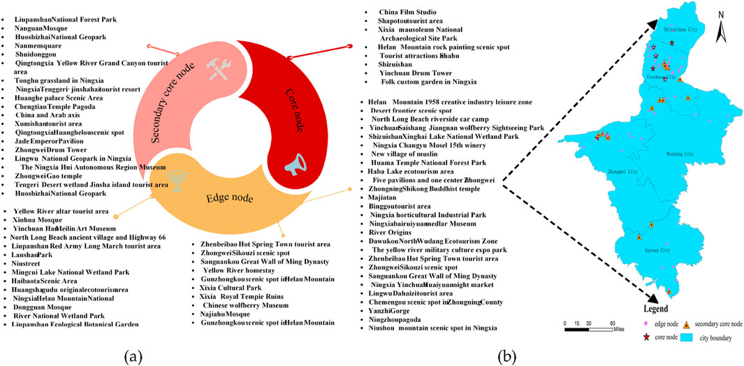
Figure 4. Core nodes, secondary core nodes, and edge nodes in Ningxia: (a) nodes categories; (b) display of nodes categories in the space.
As shown in Figure 4, the core scenic spots are mainly located in Yinchuan city and Zhongwei city; the secondary core scenic spots are mainly located along the Yellow River in Yinchuan city, Zhongwei city, and Shizuishan city; and the edge scenic spots are in all five cities; among them, Guyuan city has the most edge tourism nodes. As for edge tourism nodes, their common characteristics are relatively single-resource monomers, newly developed scenic spots, and low-grade scenic spots with scattered distribution and poor traffic accessibility.
4.3.3 Roles and positions
Roles and positions form a subset of actors in a network, characterized by relatively strong, close, or positive relationships among them. Using the CONCOR algorithm in UCINET, it is concluded that there are five roles and positions in the three levels of the whole network (Figure 5).
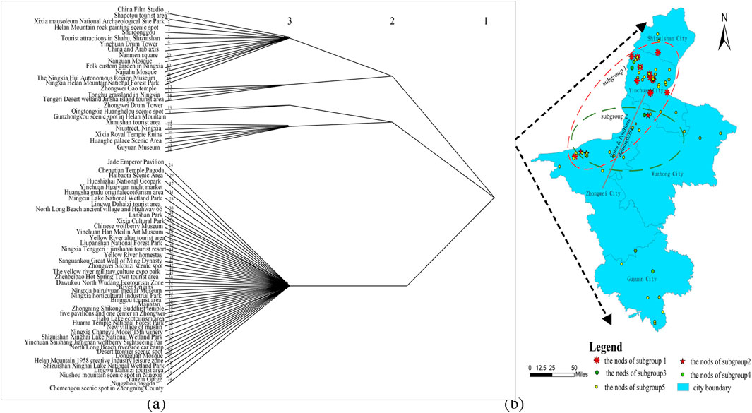
Figure 5. Roles and positions of the tourism flow network structure in Ningxia: (a) five roles and positions in the three levels of the whole network; (b) subgroups 2 and 1 in the space.
Using the CONCOR algorithm in UCINET, the roles and positions density matrix (Table 4) was generated; this paper analyzes the connections between the five subgroups.

Table 4. Roles and positions density matrix.
According to the data in Table 4 and Figure 5, subgroups 2 and 1 are closely related, with a density value of 0.054. The specific analysis shows that the nodes of subgroups 2 and 1 are mostly located in Yinchuan city and Zhongwei city, which indicates that most tourists combine the key scenic spots of Yinchuan and Zhongwei to form their key tourism routes. The formation of this trend is related to the enrichment of scenic spots in Yinchuan, the attraction and popularity of desert scenic spots in Zhongwei, the establishment and improvement of tourism infrastructure in the two cities, and the advantages of location and transportation. On one hand, Yinchuan is a famous historical and cultural city in China. It is also the first city to develop tourism in Ningxia. There are many desert landscapes, ethnic cultural landscapes, historical and cultural relics, and a perfect transportation network. On the other hand, the Shapotou tourist area in Zhongwei has become a must-see attraction for foreign tourists because of its desert tourism projects, such as sand rowing, sand playing, watching the starry sky, desert research, and the gradual establishment of the desert ecological leisure resort in recent years. Furthermore, with the continuous formation of transportation networks, the interaction between Zhongwei and Yinchuan is increasing day by day. Therefore, subgroups 2 and 1 are closely related.
4.4 Spatial characteristics of the tourism network structure
In order to further visualize the spatial structure characteristics of tourism flow, this paper uses ArcGIS combined with a matrix to generate geographic visualization of tourist footprints and spatial flow and generates the spatial structure map of tourism the flow network, which provides the spatial analysis basis for the connection strength of each node and the analysis of regional tourism development (Figure 6).
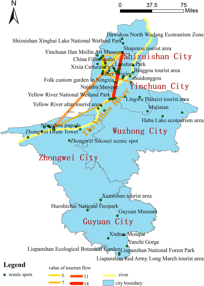
Figure 6. Spatial structure of the Ningxia tourism flow network.
As shown in Figure 6, the spatial tourism flow presents a structure of superposition and coincidence of multiple triangles in space. The most obvious tourism flow is Zhongwei–Yinchuan–Shizuishan, which indicates that these three cities are the core cities for tourists to visit. On the whole, the tourism flow in Ningxia is mainly concentrated among Yinchuan, Zhongwei, and Shizuishan, forming a “golden triangle” of Ningxia desert tourism flow, while Wuzhong and Guyuan are positioned at the periphery of the spatial structure. This distribution is influenced by these cities' tourism resources, regional economic development, infrastructure development, urban transportation accessibility, scenic spot popularity, tourism marketing, and urban distance.
First, Yinchuan, as the capital of Ningxia and a famous city with a long history, is not only rich in tourism resources, convenient transportation, good accessibility, and complete infrastructure but also has the highest overall social development level among other cities in Ningxia. Helan Mountain rock painting scenic spot and Xixia Mausoleum National Archaeological Site Park in Yinchuan are closely related to their history and culture of desert, and they are favored by tourists.
Second, Zhongwei is the nearest city to the desert. The vast desert provides rich resources for the development of desert tourism in Zhongwei. In recent years, because of the optimization of the ecological environment, the three desert tourist attractions in Zhongwei, namely, the Shapotou tourist area, Ningxia Tenggeri Jinsha tourist resort, and Tengger Desert wetland Jinsha Island, are particularly favored by tourists. Therefore, Zhongwei has become the most important destination city in Ningxia after Yinchuan.
Third, Shizuishan’s main scenic spot, namely, the Shahu tourist area, is close to Zhongwei and Yinchuan. The Shahu tourist area of Shizuishan is 41 km away from Yinchuan, which is approximately an hour’s drive. It is 26 km away from Shizuishan, which is approximately half an hour’s drive. It is an important node for tourists to visit Ningxia, second only to Shapotou. Therefore, Shizuishan city is connected with the representative scenic spots of Yinchuan and Zhongwei, forming the “golden triangle” of Ningxia desert tourism flow. These factors largely influence the tourists’ choice of scenic spots and the organization of tourist routes, which ultimately form the overall characteristics of the Ningxia tourism flow network structure.
5 Conclusion and discussion
5.1 Research conclusion
Taking Ningxia as a case study, this paper collected digital footprints of tourists from Mafengwo, Qunar, and TravelGo from January 2018 to December 2022, which were used as data for analyzing tourism flow. This paper summarizes the causes and problems of the spatial structure network of the Ningxia tourism flow in desert destinations and draws the following conclusions.
First, in terms of characteristics of tourism flow and network structure, the hot scenic spots not only include the high A-grade scenic spots in Ningxia but also include the hot cities in Ningxia; they are concentrated in the Ningxia section of the Yellow River Basin. It can be observed that the high rate of visitors in Ningxia is closely related to the grade value of the scenic spots and the popularity of the cities. In Ningxia, high-grade tourist attractions and historical and cultural relics are the most distinctive tourist attractions. At the same time, these highly attractive tourism resources are closely related to the natural geographical environment and historical and cultural development accumulation of Ningxia. As the mother river, the Yellow River has not only created the natural landscape of the Ningxia desert but also bred the Yellow River civilization with excellent historical and cultural characteristics. The tourism landscape near the Yellow River reflects the historical development of Chinese civilization; it has witnessed thousands of years evolution, the progress of China since its founding, and the socio-economic transformations in the Ningxia Hui Autonomous Region after the reform and opening-up. Therefore, in order to achieve the integrated and high-quality development of culture and tourism in Ningxia, we need to focus on the coordinated development of ecological protection, environmental construction, and socio-economic and social construction along the Yellow River; consider the Yellow River as the local tourism and social development axis; and promote the synchronous improvement of the regional social comprehensive level and people’s living standards.
Second, in terms of characteristics of the tourism node structure, the six most obvious nodes (e.g., China Film Studio, Shapotou tourist area, Shahu tourist area in Shizuishan, Xixia Mausoleum National Archaeological Site Park, Ningxia Folk Custom Garden, and Yinchuan Drum Tower) are in the core position of Ningxia tourism and are the distribution nodes of Ningxia tourism. The six nodes have high internal accessibility and are mutual sources; most tourists flow in these scenic spots. They have more connections with other nodes. They also occupy more structural hole and centrality advantages and competitive opportunities, which can better connect other unpopular tourism nodes and provide a breakthrough point for the rational allocation of tourism resources. This conclusion provides an effective reference for the future tourism development planning of Ningxia. In the future development and construction of tourism in Ningxia, We should strengthen the transportation links between the core nodes and the edge nodes, use the transportation flow as a medium to strengthen the diversion of the tourism flow, and narrow the development gap between the cold and hot spots, so as to narrow the tourism development gap between regions.
Third, in terms of characteristics of the tourism network structure, the current tourism flow network among the scenic spots in Ningxia is relatively loose, and the links between scenic spots are not very close. There is a large imbalance in the tourism network among the scenic spots in Ningxia. The core scenic spots are mainly located in Yinchuan city and Zhongwei city; the secondary core scenic spots are mainly located along the Yellow River in Yinchuan city, Zhongwei city, and Shizuishan city; and the edge scenic spots are mainly distributed in Guyuan city. Therefore, in the future tourism development of Ningxia, we need to pay more attention to the transformation, quality improvement and upgrading of tourism, the dominant position of tourism, and the impact on regional social development. By leveraging the leading and core role of Yinchuan, along with the demonstrative and driving influence of Zhongwei, we can improve the core position of tourism in less developed cities. These cities can also narrow the gap in regional tourism development by exploring models for integrating tourism with agriculture and industry.
Finally, in terms of spatial characteristics of the tourism network structure, the spatial tourism flow presents a pattern of superposition and coincidence of multiple triangles. The most obvious triangular flow direction is Zhongwei–Yinchuan–Shizuishan, which means that these three cities are the core cities. Wuzhong city and Guyuan city are less attractive to tourists compared to them. It can be observed that cities close to the Yellow River have obvious advantages in the development of tourism, while cities far away from the Yellow River have a relatively backward development of tourism due to constraints such as water resource shortage and weak industrial foundation. In the future, Ningxia can improve the development level of the relatively lagging areas of the tourism industry by strengthening the infrastructure construction of transportation and information, so as to make them keep pace with the development of the cities along the Yellow River as soon as possible, and gradually realize the coordinated development of the region and the urban and rural areas.
To sum up, Ningxia can build a high-quality tourism system with “cities as the core, scenic spots as the wings, regional linkage, and desert accent” to achieve the leap from “transit place” to “destination.” In terms of urban development and construction, it will enhance the function of transportation hubs in Yinchuan and Zhongwei through the increase in the frequency of flights and high-speed railways, develop special tourism lines, and improve the self-driving service system such as campsites and charging piles. It could also protect the ecology of the Helan Mountains and the Yellow River coastline and promote sponge city technology to regulate the climate using wetland parks to achieve high-quality development.
In the construction of tourist attractions, Ningxia can transform and upgrade scenic spots from sightseeing tourist attractions to interactive and experiential tourist attractions. Ningxia could attract more young tourists through the development of eco-tourism along the Helan Mountains and Liupan Mountains, planning and development of special industrial tourism in wine estates, and promotion of remote experiential tourism programs such as desert adventure and star camping.
In terms of regional cooperation, Ningxia could actively integrate into the “great northwest tourism community” and cooperate with Inner Mongolia to launch the “double desert crossing” (Tengger + Badanjilin) tourism activities. It could also cooperate with Gansu to build the “golden bank of the Yellow River–Silk Road grottoes” loop to expand the influence of tourist destinations. The “Shaanxi, Gansu, and Ningxia red tourism corridor” could also be launched in cooperation with Shaanxi to enrich tourism products. It is also possible to organize the International Desert Forum and the Silk Road Film Festival in conjunction with the five northwestern provinces to enhance the influence of desert tourism in Ningxia.
5.2 Discussion
Because of the easy access to tourism digital footprints, the research on the temporal and spatial characteristics of tourism flow based on tourism information data has become increasingly better, and the research scope has gradually shifted from developed areas to developing areas, which has promoted the spatial shift of geographical research and the planning shift of tourism destinations.
To some extent, this study on the tourism flow of desert tourism destinations helps extend people’s attention to desert tourism products, routes, and destinations in the tourism field and clarify the market reputation of desert tourism products and tourists’ choice preferences. At the same time, this study’s focus on tourism flow in Ningxia reflects the advantages and disadvantages of desert tourism cities, which contribute to improve their tourism planning and management ability and strengthen the contact and cooperation among cities; these efforts will help narrow the development gap between cities and promote the balanced growth of regional tourism in the future.
However, there are some limitations to this research. First, because the coverage of digital footprint information is not wide, it is difficult to accurately describe the demographic information such as tourists’ age, occupation, and income; therefore, it is difficult to accurately analyze which tourist groups prefer desert tourism and which groups do not like desert tourism. Second, because all tourism digital footprints come from Chinese domestic websites, the research on tourism footprint tracking of inbound tourists is relatively insufficient, making it difficult to distinguish the differences between domestic and foreign tourists in desert tourism products, routes, and destination choices. In future studies, we will collect travelogue information of inbound tourists from OTA websites such as TripAdvisor and Expedia, in order to provide a more comprehensive and objective situation of the destination.
In future research, multi-source data can be used to further enrich and expand the research content by issuing questionnaires, collecting online travel notes, conducting tourist behavior selection experiments, and collecting travel agency route data. Furthermore, we can expand the research content of desert tourism in Ningxia from the aspects of community residents’ participation, tourists’ experience perception, and tourists’ experience quality. Finally, in the context of the era of consumption upgrading, digital empowerment, and the outbreak of the experience economy, future research can also take spatial and developmental elasticity as the research point to study how desert tourism destinations can break through the dilemma and realize high-quality development.
Data availability statement
The original contributions presented in the study are included in the article/Supplementary Material further inquiries can be directed to the corresponding author.
Author contributions
BD: conceptualization, data curation, investigation, writing–original draft, and writing–review and editing. XG: writing–review and editing. QL: writing–original draft and writing–review and editing.
Funding
The author(s) declare that financial support was received for the research and/or publication of this article. This research was financially supported by the “National Nature Science Foundation of China” (grant number 42071186), “the Research Base for Multiethnic Cultural Integration and Regional Development of Guizhou Normal University under the State Ethnic Affairs Commission and the Research Base for Strengthening the Awareness of Chinese Ethnic Community at Guizhou Normal University under the Guizhou Provincial Ethnic and Religious Affairs Commission” (grant number 2024YB04), “Humanities and Social Sciences in Higher Education Institutions of Guizhou Province” (grant number 2024RW160), and the “Guizhou Province University Philosophy and Social Science Laboratory Pilot Construction Funding: Southwest Ethnic Cultural Heritage Digital Gene Extraction Technology and Innovation Application Laboratory” [Qianjiaozhe (2023) no. 04].
Conflict of interest
The authors declare that the research was conducted in the absence of any commercial or financial relationships that could be construed as a potential conflict of interest.
Generative AI statement
The authors declare that no Generative AI was used in the creation of this manuscript.
Publisher’s note
All claims expressed in this article are solely those of the authors and do not necessarily represent those of their affiliated organizations, or those of the publisher, the editors and the reviewers. Any product that may be evaluated in this article, or claim that may be made by its manufacturer, is not guaranteed or endorsed by the publisher.
Supplementary material
The Supplementary Material for this article can be found online at: https://www.frontiersin.org/articles/10.3389/fenvs.2025.1544890/full#supplementary-material
References
Arreeras, T., Arimura, M., Asada, T., and Arreeras, S. (2019). Association rule mining tourist-attractive destinations for the sustainable development of a large tourism area in Hokkaido using Wi-Fi tracking data. Sustainability 11 (14), 3967. doi:10.3390/su11143967
Asero, V., Gozzo, S., and Tomaselli, V. (2016). Building tourism networks through tourist mobility. J. Travel Res. 55 (6), 751–763. doi:10.1177/0047287515569777
Beritelli, P., Reinhold, S., and Laesser, C. (2020). Visitor flows, trajectories and corridors: planning and designing places from the traveler's point of view. Ann. Tour. Res. 82, 102936. doi:10.1016/j.annals.2020.102936
Bowden, J. (2003). A cross-national analysis of international tourist flows in China. Tour. Geogr. 5 (3), 257–279. doi:10.1080/14616680309711
Bull, A. T., Andrews, B. A., Dorador, C., and Goodfellow, M. (2018). Introducing the Atacama Desert. Ant. Leeuw 111, 1269–1272. doi:10.1007/s10482-018-1100-2
Carnicelli-Filho, S., Schwartz, G. M., and Tahara, A. K. (2010). Fear and adventure tourism in Brazil. Tour. manage 31 (6), 953–956. doi:10.1016/j.tourman.2009.07.013
Chancellor, C., and Cole, S. (2008). Using geographic information system to visualize travel patterns and market research data. J. Travel Mark Tourism, 25 (3–4), 341–354. doi:10.1080/10548400802508440
Cole, D. N., Foti, P., and Brown, M. (2008). Twenty years of change on campsites in the backcountry of Grand Canyon national park. Environ. Manage 41, 959–970. doi:10.1007/s00267-008-9087-5
Dorn, T., and Day, M. (2025). Spatial variability in aeolian abrasion: ibex dune field, Death Valley National park. Sedimentology 72 (1), 258–274. doi:10.1111/sed.13233
Gan, C., Voda, M., Wang, K., Chen, L., and Ye, J. (2021). Spatial network structure of the tourism economy in urban agglomeration: a social network analysis. J. Hosp. Tour. Manag. 47, 124–133. doi:10.1016/j.jhtm.2021.03.009
Gidebo, H. B. (2021). Factors determining international tourist flow to tourism destinations: a systematic review. J. Hosp. Tour. Manag. 12 (1), 9–17. doi:10.5897/jhmt2019.0276
Gil-Sánchez, J. M., Herrera-Sánchez, F. J., Rodríguez-Siles, J., Díaz-Portero, M. Á., Arredondo, Á., Sáez, J. M., et al. (2025). Body size rules habitat selection and population declines after drought periods in a carnivore community of the Sahara Desert. Mamm. Biol. 105 (1), 69–81. doi:10.1007/s42991-024-00461-z
González-Pérez, J. M. (2019). The dispute over tourist cities. Tourism gentrification in the historic Centre of Palma (Majorca, Spain). Tour. Geogr. 22 (1), 171–191. doi:10.1080/14616688.2019.1586986
Gunn, C. A., and Var, T. (2020). Tourism planning: basics, concepts, cases. Routledge. doi:10.4324/9781003061656
Kádár, B., and Gede, M. (2021). Tourism flows in large-scale destination systems. Ann. Tour. Res. 87, 103113. doi:10.1016/j.annals.2020.103113
Khater, M., Ibrahim, O., Al-Salim, F., and Faik, M. (2025). Weaving tales: the impact of storytelling in tourism guides on cultural immersion. Touri Recreat. Res., 1–16. doi:10.1080/02508281.2024.2448887
Lee, Y., and Kim, I. (2018). Change and stability in shopping tourist destination networks: the case of Seoul in Korea. J. Destin. Mark. Manage. 9, 267–278. doi:10.1016/j.jdmm.2018.02.004
Leiper, N. (1989). Main destination ratios: analyses of tourist flows. Ann. Tour. Res. 16 (4), 530–541. doi:10.1016/0160-7383(89)90007-8
Liu, J. (2009). Lectures on whole network approach: a practical guide to UCINET. Shanghai People’s Publishing House.
Margulis, M., and Rosen, S. A. (2025). Nabatean tent sites on the ruhot plain, central Negev, and nomadic visibility. B Am. Soc. Overseas Res. 393 (1). doi:10.1086/734106
Mou, N., Yuan, R., Yang, T., Zhang, H., Tang, J. J., and Makkonen, T. (2020). Exploring spatio-temporal changes of city inbound tourism flow: the case of Shanghai, China. Tour. manage 76, 103955. doi:10.1016/j.tourman.2019.103955
Mousazadeh, H., Zhu, K., Ghorbani, A., Almani, F. A., Arabi, M., Parvar, F., et al. (2023). Sustainable cultural heritage landscape: an imaginary journey inside the veins of deserts. Front. Sus. Food Sys. 7 (1218881). doi:10.3389/fsuf.2023.1218881s.2023.121888
Narayanan, Y., and Macbeth, J. (2009). Deep in the desert: merging the desert and the spiritual through 4WD tourism. Tour. Geogr. 11 (3), 369–389. doi:10.1080/14616680903032783
Pearce, D. G. (1987). Spatial patterns of package tourism in Europe. Ann. Tour. Res. 14 (2), 183–201. doi:10.1016/0160-7383(87)90084-3
Pomfret, G. (2006). Mountaineering adventure tourists: a conceptual framework for research. Tour. Manage 27 (1), 113–123. doi:10.1016/j.tourman.2004.08.003
Reichel, A., and Uriely, N. (2003). Sustainable tourism development in the Israeli Negev Desert: an integrative approach. J. Park Recreat. Adm. 21 (4).
Ruiz-Ortega, M. J., García-Villaverde, P. M., De La Gala-Velásquez, B., Hurtado-Palomino, A., and Arredondo-Salas, Á. Y. (2021). Innovation capability and pioneering orientation in Peru’s cultural heritage tourism destinations: conflicting environmental effects. J. Hosp. Tour. Manag. 48, 441–450. doi:10.1016/j.jhtm.2021.07.012
Saeed, M., Naaz, S., Tasleem, M., Alshammari, N., Kaur, A., Alam, M. J., et al. (2024). Bridging tradition and innovation: the hail desert plant database for drug discovery. Indian J. Pharm. Educ. 58, s623–s630. doi:10.5530/ijper.58.2s.66
Salas-Olmedo, M. H., Moya-Gómez, B., García-Palomares, J. C., and Gutiérrez, J. (2018). Tourists' digital footprint in cities: comparing Big Data sources. Tour. Manage 66, 13–25. doi:10.1016/j.tourman.2017.11.001
Santarém, F., and Paiva, F. (2015). Conserving desert biodiversity through ecotourism. Tour. Manag. Perspect. 16, 176–178. doi:10.1016/j.tmp.2015.07.016
Schmidt, J., and Uriely, N. (2019). Tourism development and the empowerment of local communities: the case of Mitzpe Ramon, a peripheral town in the Israeli Negev Desert. J. Sustain Tour. 27 (4-6), 805–825. doi:10.1080/09669582.2018.1515952
Sutton, J. (2016). From desert to destination: conceptual insights into the growth of events tourism in the United Arab Emirates. Anatolia 27 (3), 352–366. doi:10.1080/13032917.2016.1191765
Keywords: spatial structure, desert destination, tourism flow, tourist digital footprint, Ningxia
Citation: Dong B, Guo X and Luo Q (2025) Research on the spatial structure of desert tourism flow based on ecological digital footprints: a case study of Ningxia. Front. Environ. Sci. 13:1544890. doi: 10.3389/fenvs.2025.1544890
Received: 16 December 2024; Accepted: 13 March 2025;
Published: 27 March 2025.
Edited by:
Chengyu Li, Zhengzhou University of Light Industry, ChinaReviewed by:
Dai Xiaomin, Xinjiang University, ChinaXiaodi Niu, Henan University of Technology, China
Lei Li, Hunan Normal University, China
Copyright © 2025 Dong, Guo and Luo. This is an open-access article distributed under the terms of the Creative Commons Attribution License (CC BY). The use, distribution or reproduction in other forums is permitted, provided the original author(s) and the copyright owner(s) are credited and that the original publication in this journal is cited, in accordance with accepted academic practice. No use, distribution or reproduction is permitted which does not comply with these terms.
*Correspondence: Baoling Dong, ZG9uZ2Jhb2xpbmcxMTkwMDBAMTYzLmNvbQ==