 Luis Zambrano1*
 Tania Fernandez Vargas1
 Edgar J. González2
 Alma Mendoza-Ponce3
 Manuel Llano Vazquez Prada4
 Carla Flores Lot4
 Rogelio O. Corona-Nuñez5
 Enrique Martínez-Meyer1
- 1Instituto de Biología, UNAM Ciudad Universitaria, México, Mexico
- 2Facultad de Ciencias, UNAM Ciudad Universitaria, México, Mexico
- 3Programa de Investigación en Cambio Climático de la UNAM, and Laboratorio Nacional de Biología del Cambio Climático, SECIHTI, Ciudad de México, México
- 4CartoCritica A.C. Ciudad de México, México, Mexico
- 5Universidad Autónoma Metropolitana, Unidad Cuajimalpa, México, Mexico
Introduction: Megaprojects are strategically envisioned to boost regional development. Still, they drive ecosystem changes that generate ecological impacts in space and time beyond construction sites, particularly those established in rural regions, as their economic goals often trigger broader landuse changes. These distal ecological impacts are frequently overlooked, but their evaluation is critical to assess changes in ecosystem services that provide quality of life to the local people. To understand the effects on ecosystem services, this study analyzed both the proximal and distal impacts of the “Tren Maya” railroad megaproject.
Methods: Using InVest models, which provide spatial quantitative analysis using land use information, among other variables. We evaluated three ecosystem services: habitat quality, pollination, and carbon sequestration across the Yucatán Peninsula, Mexico. We assessed historical (2002) and recent (2017) ecosystem services. We projected three scenarios to 2050: (a) future without train, land use change using previous trends, (b) proximal impacts of the Tren Maya, and (c) combined proximal and distal impacts of the Tren Maya.
Results: Results show significant declines of all evaluated ecosystem services in the three future scenarios, with the most pronounced reductions with distal impacts. Ecosystem types have different impacts, where tropical rainforests and tropical dry forest are the most affected. Geographically, the northwestern region of the Peninsula (the most populated) is more affected, while protected areas in the southern region mitigate some impacts.
Discussion: The analysis shows that distal impacts are more significant in the habitat quality than the other two ecosystem services evaluated. Our findings underscore the need for megaproject evaluations to incorporate both proximal and distal impacts to ensure sustainable development.
1 Introduction
Megaprojects are large-scale infrastructure endeavors involving financial investments of more than 1 billion USD (Han et al., 2024). They have multiple goals and intervention areas, focusing, in many cases, on urban regions (del Cerro Santamaría, 2021). While these projects are considered growth drivers, and some look to reduce human impact in urban areas (Li et al., 2022), they have recently received social resistance (Witz et al., 2021) since, in many cases, they disrupt ecological dynamics (Merrow, 2024). This is particularly important in megaprojects aiming to develop rural regions, such as highways and railways, to increase connectivity. The scale of these projects in rural areas can result in significant ecological disturbances, requiring a thorough analysis of their environmental impacts (Gellert and Lynch, 2003) to balance their benefits with the ecological costs (Marsden and Lenton, 2024).
The environmental assessment of projects has traditionally concentrated on their immediate, localized impacts, referred to as “direct” effects (Labarraque et al., 2015). Here, we refer to these impacts as “proximal”, as they encompass ecological changes near the construction site, such as reductions in water flow, habitat degradation, pollution, and altered aesthetics. While specific proximal impacts, like habitat fragmentation, can extend beyond the immediate construction area, most remain confined to zones adjacent to the infrastructure (Tardieu et al., 2015; Metzger et al., 2021).
Since the goal of megaprojects in rural areas is the economic development of local people, its influence extends beyond their immediate surroundings, affecting ecosystems at multiple spatial and temporal scales (Marsden and Lenton, 2024). They promote cumulative impacts on the region (Siqueira-Gay, 2021), which drives land-use changes across broader landscapes (Gellert and Lynch, 2003; Díaz Perera and Gasparello, 2023). Therefore, in addition to proximal impacts, these megaprojects generate “distal” impacts that unfold far from the construction site and over long periods. These distal impacts, akin to the medical term describing effects far from the primary intervention site, reflect the systemic outcome of these projects. Distal impacts have more extensive changes in land use, which are capable of modifying the ecosystems into a tipping point that would revert all the potential economic benefits of the intervention (Marsden and Lenton, 2024).
Since we are studying spatial and temporal scales, we use the terms “proximal” and “distal,” which we consider better describe the phenomena we analyze in this manuscript. We are using these terms instead of “direct” and “indirect” because these others also refer to complex dynamics, such as higher-order interactions (Schamberg et al., 2020), which were not evaluated in this research. For instance, a railroad megaproject may affect ecosystems along its immediate path and trigger land-use changes farther abroad by facilitating agricultural expansion, urbanization, and other activities with impacts on natural ecosystems (Vickerman, 2017).
Distal impacts become more relevant when the evaluation focuses on the effects on ecosystem services. Most analyses of any human intervention affecting a region evaluate the changes in the ecosystem’s components and, occasionally, its function; however, assessing the reduction of ecosystem services is less common (Sonter et al., 2018). Ecosystem services assessment evaluates how the vegetation type, ecosystem dynamics, and the effects of these changes on the wellbeing of the local communities are changing (Zhou et al., 2024), including vulnerability reduction to extreme events related to climate change (Leal Filho et al., 2021). Therefore, ecosystem service assessments should be incorporated early in the planning stages of large-scale infrastructure projects.
In this study, we assess megaprojects’ proximal and distal impacts, using the “Tren Maya” railway system in southeastern Mexico as a focal case. This 1,525-km-long rail network, which costs reached 23 billion USD, aims to stimulate economic development across the Yucatán Peninsula by enhancing tourism and agro-industrial activities. The “Tren Maya” project was announced in August 2018 and its construction started in December of the same year, ending by December 2024 (Gobierno-Mexico, 2020).
Among many ecosystem services relevant to the quality of life of the local people, we focused on three essential services for these rural communities to evaluate the Tren Maya’s proximal and distal impacts: habitat quality, pollination, and carbon sequestration. Habitat quality and pollination are related to local activities that depend upon biodiversity, and carbon sequestration is related to climate change.
Local biodiversity is a measure of habitat quality, which plays a significant role in sustaining traditional practices of the rural communities, which are mainly composed of Mayan groups (López-Castilla et al., 2024). The loss of high-quality habitats has far-reaching implications for the region’s biodiversity, affecting ecosystem services such as pollination (Bengtsson et al., 2019). Traditional agricultural practices such as the “milpa” system are compatible with habitat conservation (Ellis and Porter-Bolland, 2008). The milpa system is a polyculture based on maize and other crops that rotate with tropical forests over a period of 10–25 years (Nigh and Diemont, 2013). The milpa production process depends on mutualistic dynamics between plants and insects, which consequently requires native pollinator species (Fonteyne et al., 2023; Grof-Tisza et al., 2024). Therefore, changes in land use can lead to productivity losses due to poor soils and pollinators’ reduction (McGroddy et al., 2013).
The third ecosystem service assessed was carbon sequestration, which is produced by native forests, and it is crucial in reducing vulnerability to climate change (Libert-Amico et al., 2022). Their destruction makes the region more susceptible to increasingly intense hurricanes (Appendini et al., 2019), for which small rural communities are especially vulnerable (McGroddy et al., 2013).
This research aims to evaluate the proximal and distal impacts of the megaproject Tren Maya on ecosystem services in the Yucatan Peninsula. To this end, the research analyzed the trajectory of these ecosystem services over the last 20 years to create three scenarios to 2050: a) considering only previous land use trends without the train construction, b) considering the proximal impacts of the Tren Maya, and c) considering proximal and distal impacts of the Tren Maya. Our aim is to contrast how megaproject construction would impact these ecosystem services in the future.
We hypothesize that the reduction of ecosystem services produced by the proximal impacts of the Tren Maya in the Yucatan Peninsula will be significantly more extensive than without this megaproject. A second hypothesis is that, the proximal impacts will be substantially smaller than the distal ones, since the construction effect will extend to the entire peninsula. A third hypothesis is that proximal and distal impacts will vary depending on the vegetation type and ecosystem service.
2 Materials and methods
2.1 Study area
The study area covers the Tren Maya railway project across the entire Yucatán Peninsula in southeastern Mexico, which includes the states of Campeche, Yucatán, and Quintana Roo, as well as parts of Tabasco and Chiapas. The region spans 147,918 km2, with coordinates ranging from 21° 36′ N to 17° 49′ N latitude and 86° 44′ W to 90° 59′ W longitude. The Yucatan Peninsula is part of the Neotropical corridor influenced by the Amazon (Burbano-Girón et al., 2022) and harbors diverse ecosystems that provide critical ecosystem service to rural people. The environmental assessment of the Tren Maya was divided into seven independent phases. All of these environmental assessments were conducted after the construction began. These assessments were concentrated on proximal impacts and were performed on independent sections of the projected route (SEMARNAT, 2023).
The Yucatan Peninsula is characterized by a flat topography and minimal surface runoff owing to its karstic soil composition. As a result, rainwater rapidly infiltrates to the aquifer, giving rise to the distinctive sinkholes, popularly known as “cenotes,” contributing to the region’s rich freshwater biodiversity (Zambrano et al., 2006). Aquifer discharge along the coastline supports the formation of extensive lagoon systems throughout much of the peninsula. Surface water basins are limited, with notable examples being the Champotón River in Campeche and the Hondo River in southeastern Quintana Roo (Figure 1A). Owing to their ecological significance and high biodiversity, several areas within the peninsula have been designated as Biosphere Reserves or Protected Natural Areas, collectively covering 22.8% of the total land area (Figure 1B).
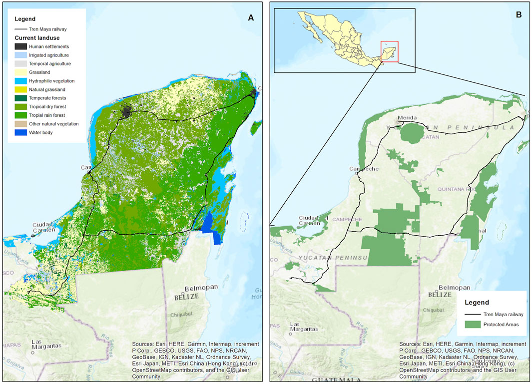
Figure 1. Study area: the Yucatan Peninsula 1 (A). Vegetation types and land use cover in 2017, obtained from INEGI Series VII (INEGI, 2021) 1 (B). Natural Protected Areas within the peninsula with the Tren Maya project route indicated.
The Yucatan Peninsula supports different vegetation types, primarily shaped by its warm and humid climate and soil characteristics (Islebe et al., 2015; Reyes-Palomeque et al., 2021). The most widespread are tropical rainforests and tropical dry forests. Wetlands are mainly concentrated along the coastline, while natural grasslands dominate the northern part of the peninsula. The least common ecosystem, temperate forest, is found in the south-central region (Figure 1A).
2.2 Ecosystem services analysis
We divide the method into four sections to evaluate ecosystem services: 1. Data gathering to create land use maps for 2002 and 2017; 2. Land use change scenarios up to 2050 based on changes from the past 2 decades; 3. Quantification of ecosystem services for all scenarios and previous years; 4. Statistical analysis of each ecosystem service change over time and in the different scenarios. Each section has multiple steps. We provide more information in Supplementary Appendix 1 for steps that require it.
2.3 Data gathering to build 2002 and 2017 maps
We used two land-use and vegetation maps provided by the National Institute of Statistics and Geography (INEGI). We named the first map “Baseline”, which was obtained from INEGI Series III with 2002 information (Instituto Nacional de Estadística y Geografía, 2005). We named the second map “Current”, which was obtained from INEGI Series VII, with 2017 information (a year before the construction of the railroad began) (Instituto Nacional de Estadistica y Geografia, 2021). For more information about the series and rasterization see Appendix. We categorized land uses into vegetation types, including wetlands, grasslands, temperate forests, tropical dry forests, tropical rainforests, other natural vegetation (such as coastal dune vegetation and palm groves), croplands (both temporary and irrigated), pastures for cattle, and urban areas.
We also used information on mobility infrastructure, such as roads and highways, was obtained from the government web pages of INEGI (SCT, 2014; INEGI, 2020). Finally, we created a shapefile map of the Tren Maya railroad, train stations, hotels, on the new Tulum airport were digitized from the ArcMap base map (version 10.8).
2.4 Projected land use change scenarios to 2050
We developed the land use/land cover (LULC) change model using DINAMICA-EGO software version 5.2.1 to project future land use changes. The utilizes historical LULC maps to calculate change rates, which define the magnitude of transitions among land use classes, and applies statistically weighted explanatory variables to determine the spatial distribution of changes through probability maps (Rodrigues and Soares-Filho, 2018; see Appendix).
The model generates different outcomes depending on variations in its parameters (i.e., transition rates or explanatory variables). We evaluated the correlation among the variables and selected the most significant ones for each transition based on previous studies (Ellis et al., 2010; Pérez-Vega et al., 2012), using INEGI Series II, III, IV, and V, Then, we validated the correlation results and model scenario for 2017 against INEGI Series VI (see Appendix).
To build the scenarios, we divided the study area into four zones based on the proximity to the Tren Maya stations and railroad segments (see Appendix). Based on this zonation, we created three future scenarios extending to 2050 by modifying the transition rates as follows: (1) Future without the train (FWT), which used the average historical rates of land cover change, representing a baseline scenario without the influence of the Tren Maya. (2) Proximal impacts of the Tren Maya, built upon the FWT baseline, this scenario adds a spatial layer of the railway and station infrastructure, assuming increased tourism and freight movement. We included a 200-m-wide deforestation corridor, causing landscape fragmentation, based on planning documents from construction authorities. (3) Distal impacts of the Tren Maya., which represents the worst-case scenario by the DINAMICA-EGO model, incorporating the highest projected land use change rates, minimal regeneration rates, and additional tourism facilities currently under construction linked to the Tren Maya project.
2.5 Ecosystem services quantification
We used the Integrated Valuation of Ecosystem Services and Tradeoffs (InVest Integrated Valuation of Ecosystem Services and Tradeoffs, 2023) software to assess ecosystem services. This open-source tool enables spatially explicit evaluations of these services. Using InVEST, we evaluated the ecosystem services in 2002 and 2017 and the three generated scenarios (see above). We focused on three services: (1) habitat quality (Forman et al., 2003; Martínez et al., 2025), (2) carbon sequestration (Eggleston et al., 2006; Ersoy Mirici and Berberoglu, 2024) and (3) pollination (Hill et al., 2019; Meldrum et al., 2024). For more information about variables used to evaluate these ecosystem services, see the Appendix. The program generates different types of values for each ecosystem service. For habitat quality, pixel values are ranked between 0 (destroyed habitat) and 1 (the highest habitat suitability). For carbon sequestration, values show tons per pixel. For pollination, values show an abundance index per pixel ranging from 0 (none) to 1 (highest).
For habitat quality ecosystem service, InVEST requires including values for different type of threats. We defined threats to the ecosystem service of habitat quality as anthropogenic land uses such as roads, urban areas, agricultural and cattle grazing activities, railroads, train stations, and the newly constructed hotels and airports. InVEST defines threats only for the habitat quality ecosystem service. In distal impacts these threats can have different values based on the intensity of economic activity or the size of infrastructure (Table 1). Land use changes driven by distal impacts were primarily linked to urban areas and had the most significant negative impact on ecosystem services. Intensive agriculture, which requires irrigation and the use of agrochemicals, had a greater impact than traditional farming (Turner et al., 2001). Similarly, cattle grazing on grasslands reduced ecosystem services previously provided by tropical dry forests. Additional impacts included airports and hotels constructed within rainforest areas along the Tren Maya route.
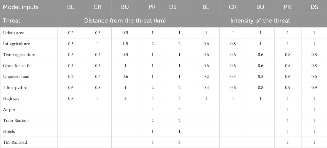
Table 1. Maximum values used in the InVest model of distances from the threat and the intensity of the threat. Distance from the threat is the length of influence a threat has on the ecosystem service, measured in km. The influence is decaying linearly as the distance increases from the edge of the threat. The intensity is between 0 (null) and 1 (strongest) possible influence from the threat to the ecosystem. BL = baseline map. CR = current map, BU = business-as-usual scenario, PR = Proximal impacts of Tren Maya scenario, and DS = Distal impacts of Tren Maya scenario. 1-line pvd rd = one line paved road.
Therefore, we added the Tren Maya route as a threat to the ecosystem. We assumed these threats affect all vegetation types equally. The threats were not used as separate inputs for the other two ecosystem services. Instead, we created a raster map layer that included all variables and distances from threats (Table 1), using the ArcGIS software (version 10.8; (ESRI, 2021). Each threat was assigned a different influence on habitats based on proximity and impact. Values ranged from 0 (lowest impact) to 1 (largest possible impact). The reduction in effect intensity with distance (in km) depended on the type of impact. For example, unpaved roads had a smaller impact than highways, and the intensity of their effect decreased with distance.
2.6 Statistical analysis
To make a quantitative evaluation of the changes in ecosystem services from the InVEST models, we divided the study area into 25-ha quadrates. Each quadrate was assigned to one of the three most abundant vegetation types (wetland, tropical dry forest, tropical rainforest) based on the 2002–2005 Series III dataset. The dominant vegetation type (having the largest covering area) was selected if multiple vegetation types were present within a quadrant. This classification remained consistent across all future scenarios, even if the quadrate became urbanized in subsequent years. Each quadrate produced an average value for the respective ecosystem service. For visualization purposes, spatial data were reclassified into four impact categories: very low, low, medium, and high, using natural breaks (Jenks method) in ArcGIS (ESRI, 2021). This classification was also applied to evaluate changes in vegetation cover per hectare across different classes.
We fitted generalized linear mixed models (GLMMs) with a beta distribution to estimate the average value of each ecosystem service in the baseline and in different current and future scenarios. We divided the value of each ecosystem service by vegetation type. We used the beta distribution to describe the response variable distributions because the habitat quality and pollination abundance indices fall within the [0, 1] interval. We divided the carbon value by 10,000 to fit this interval. These models were fitted using the brms package (Bürkner, 2017; 2021) in R (Team, 2012), and we extracted the estimated mean and standard deviation associated with each ecosystem service and scenario.
3 Results
We found a reduction of natural vegetation and ecosystem services between 2002 and 2017 both spatially (Figure 2) and quantitatively (Table 2). Across the entire Yucatan Peninsula, areas without natural vegetation (light green; Figure 2) have increased by approximately 7,530 km2 (Table 2). Urban areas have expanded by around 930 km2, agricultural land increased by nearly 4,700 km2, and grazing areas grew by 1,900 km2. This comparison highlights a notable expansion of anthropogenic landscapes, particularly in the northern part of the peninsula and nearby protected areas, where road density is higher (Figure 1).
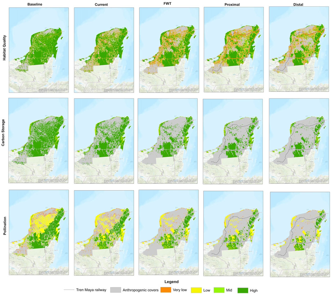
Figure 2. Changes in three ecosystem services across the Yucatan Peninsula modeled using InVest. The first two columns represent ecosystem services for the baseline year 2002 (INEGI, 2005) and the current year 2017 (INEGI, 2021). The following three columns represent projected values to 2050 under three scenarios: FWT (future without train), Proximal impacts of the Tren Maya (considering only the construction), and Distal impacts of the Tren Maya (potential effects from associated projects triggered by the megaproject).
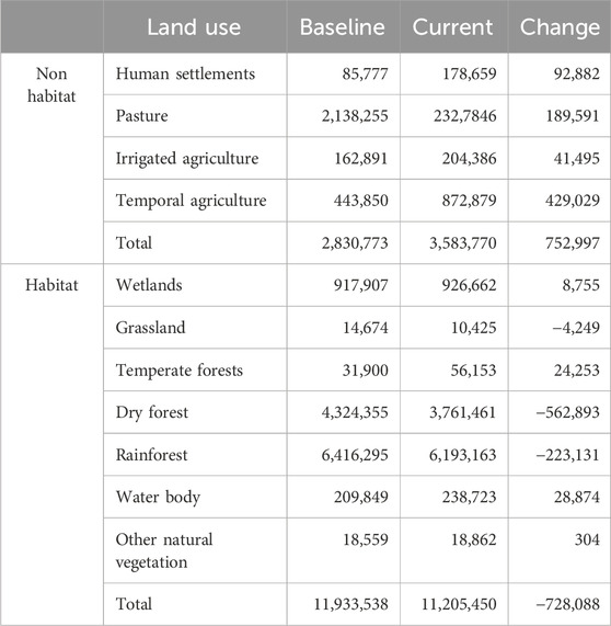
Table 2. Land use change area (ha) in the Yucatan Peninsula during the first decades of the 21st century. The baseline (2003) was obtained from INEGI Series III (INEGI, 2005), while the current data (2017) was obtained from INEGI Series VII (INEGI, 2021).
As a result of this historical increase in anthropogenic landscapes, there has been a corresponding decline in all three ecosystem services studied. The most significant reductions are concentrated in the northwestern part of the peninsula (Figure 2). Under the Tren Maya distal impacts scenario, only small patches of high ecosystem service values remain, predominantly in the two large protected areas: Calakmul and Sian Ka’an. In contrast, much of the rest of the Yucatan Peninsula, which once provided substantial ecosystem services at the beginning of this century, shows a near-total depletion of these services in the most recent years and projected scenarios. The results reveal that roads and the proximal and distal impacts of the Tren Maya are driving a reduction of habitat quality. In contrast, this reduction is less pronounced in protected areas but still evident.
The analysis provides insight into the projected performance of ecosystem services under future land-use change scenarios. The first significant decline in all three ecosystem services is observed in the future without train (FWT) scenario. If land use continues to change at the same rate as it has done in the first quarter of this century, there will be a significant depletion of all ecosystem services, as well as a homogenization of this depletion across the region in those services most affected, even without the construction of the Tren Maya (Figure 3). However, the construction of this megaproject exacerbates these adverse effects. The proximal impacts of the Tren Maya further diminish all ecosystem services, with a reduction of up to 21.7% in pollination in the tropical rain forest (Figure 3). When analyzing the reductions in the distal scenario, we observed variations among ecosystem services. While carbon sequestration and pollination experienced relatively modest declines, habitat quality substantially decreased, particularly in the two crucial vegetation types: tropical rainforest and tropical dry forest (Figure 3).
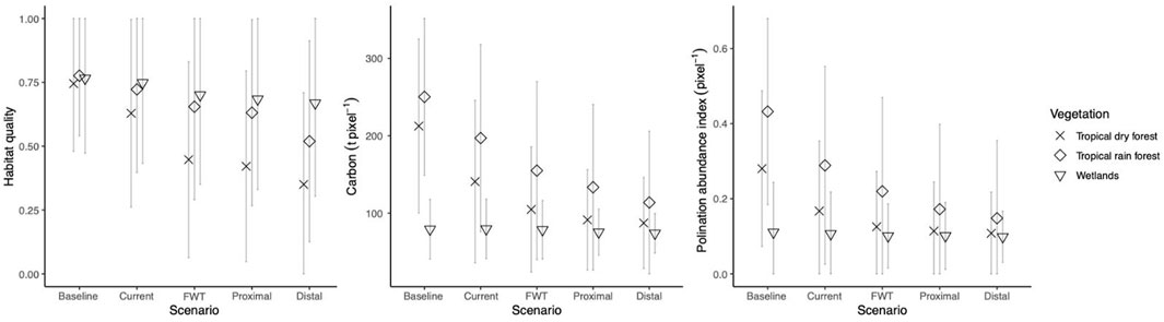
Figure 3. Average values estimated using the beta distribution (see Methods) for each ecosystem service analyzed with InVEST, based on baseline data from 2002 (INEGI, 2005) and current data from 2017 (INEGI, 2021). Three future scenarios were modeled: Future without train (FWT), Proximal impacts, and Distal impacts.
4 Discussion
The findings of this study indicate a substantial decline in the three ecosystem services since the onset of the 21st century. However, this depletion appears to be the result of a long-term trend. This decline is attributed to the proliferation of tourism infrastructure and agro-pastoral activities that have already been present on the peninsula (Torres-Mazuera et al., 2021). For more than 100 years, Mexican rail mobility projects have been implemented in regions that explicitly seek to boost economic activities. However, their construction has not always decreased poverty; they promoted land abandonment and migration to urban poles (Asher and Novosad, 2018). These lands are sold or rented to consortia that promote intensive agriculture and tourism (García-Frapolli et al., 2007), which enhances deforestation in large areas. Consequently, such developments, driven by enhanced transportation infrastructure, expand the ecological footprint beyond its physical boundaries. This can be seen in Figure 3, which shows a significant reduction in ecosystem services over the past 20 years.
Results show a clear trend of economic activities over the last 2 decades, and the acceleration of the reduction of ecosystem services will continue. A future without trains suggests that the region will continue to develop infrastructure for mobility, such as roads and streets. This can be seen in Figure 2, which shows the area close to urban areas. Road development significantly reduces large ecosystems like tropical dry forests and rainforests (Echánove Huacuja, 2021). This will especially happen in the central part of the peninsula. This area has experienced an increase in intensive agriculture in recent decades. Tourism-related developments along the Caribbean coast have further exacerbated ecosystem loss, particularly since the mid-20th century (Gómez et al., 2022; Nguyen et al., 2023). This scenario also shows an initial decline in ecosystem services in tropical rainforests and wetlands, even within protected areas as it seen on the scenario maps. The relatively milder effects in this area can be attributed to the absence of dense road networks near Sian Ka´an and Calakmul Biosphere reserves, the two major reserves.
The Tren Maya seem to be the coda of a vision for the peninsula that lasted for over a century, during which railroads were conceived as keystones for regional progress (Díaz Perera and Gasparello, 2023). Therefore, the depletion of the ecosystem services is larger in scenarios, when including proximal and distal impacts of the Tren Maya. These scenarios suggest that the megaproject potentially leads to a larger reduction of the three ecosystem services.
The proximal impacts of the Tren Maya significantly reduce habitat quality, pollination, and carbon sequestration along the train route. This reduction is more significant in the pollination ecosystem service compared to the other two (Figure 3). However, other ecosystem services have also been affected, with almost half a million tons of carbon captured in vegetation being removed in the construction of the train (Hernandez-Stefanoni et al., 2024). Recent data shows that the construction of the second part of the train (from Cancún to Escárcega), which hosts the largest carbon density (Hernandez-Stefanoni et al., 2024), deforested more than 60 km2, most of which correspond to highly conserved tropical rainforest (Consejo Civil Mexicano para la Silvicultura Sostenible, 2024). This track section also suffered from the destruction of dozens of cenotes along the Caribbean coast due to the need for a basement with columns sustaining the train (Hunter K, 2024). These local effects exacerbate habitat fragmentation in the land and in the aquifer.
The distal impacts of the Tren Maya amplify the negative effect on the three ecosystem services evaluated, particularly in the tropical rainforest (Figure 3). The construction of new touristic centers and agricultural developments can be the reason for this significant reduction. Maps show a reduction in habitat quality even within the Calakmul Biosphere Reserve and other areas affected by the railway (Huerta-Rodríguez et al., 2024). According to UN-Habitat, the project is expected to increase the human population in the region by 50% in a decade (ONU-Habitat, 2020). New roads to promote high-end tourism are being constructed, even within reserves like Calakmul and Sian Ka’an (called “Puerta al Mar”). These roads exemplify the unforeseen distal impacts of megaprojects, where unplanned infrastructure emerges, threatening conservation efforts.
When we compare proximal and distal impacts, ecosystems’ responses to megaprojects do not seem linear. The difference in ecosystem services’ responses to FWT and proximal and distal impacts depends mainly on the type of vegetation affected. While pollination and carbon sequestration show gradual declines, habitat quality experiences a steep reduction, particularly in tropical rainforests and dry forests. This sharp decline in habitat quality may have serious consequences; we will discuss some examples in the following paragraphs.
The habitat degradation in areas around the project makes wildlife crossings ineffective, as the surrounding ecosystems cannot support viable large-mammal populations or animals do not use them (González-Gallina et al., 2022; Hidalgo-Mihart et al., 2022). Compensation programs from proximal impacts to reduce fragmentation for mammals with crossing structures are considered. This reduced habitat quality leads to a fragmentation process that is particularly difficult for large mammals (Carrillo et al., 2019). Connectivity is critical for large endangered mammals like jaguars, white-lipped peccaries, and tapirs (González-Gallina et al., 2022; Reyna-Hurtado, 2024). Since habitat quality is crucial for maintaining native species’ populations and fostering biodiversity (Kearney, 2006), such as the Baird tapir (Naranjo et al., 2015; Reyna-Hurtado, 2024), with distal impacts, these crossing structures may not have the expected compensatory effect.
Other consequences of the reduction of habitat quality caused by distal impacts may be present in dynamics that affect ecosystem services not measured in this analysis because the model used has limitations to make proper and objective evaluations of other highly important ecosystem services, such as water amount and quality, which is strongly affected by the increase of intensive agriculture. High habitat quality improves the infiltration performance to the aquifer whereas intensive agriculture may lixiviate pollutants to the aquifer. Historically, large territories of land in the Yucatan Peninsula are sold or rented to agricultural and tourism consortia (García-Frapolli et al., 2007), leading to deforestation. One of the Tren Maya project goals is related to the increase of intensive agriculture, which in karstic soil requires large quantities of agrochemicals. Fertilizers and pesticides infiltrate to the aquifer, changing its dynamics (Arcega-Cabrera et al., 2021). The groundwater flow goes mainly from the center to the edges of the Yucatan Peninsula, where most of the human population is settled (Bauer-Gottwein et al., 2011). Before the construction of the train, 30% of the drinking water obtained from cenotes contained organochlorine pesticides, particularly in the northern part of the peninsula (Rodríguez et al., 2018). Considering the reduction of the habitat quality due to intensive agriculture, this number may increase dramatically. Agrochemical runoff from agriculture may alter erosion dynamics, contributing to habitat degradation across ecosystems linked by the aquifer (Vilhar et al., 2022). This would affect the water quality in the cenotes (Moreno-Pérez, 2021) needed for water supply and tourism.
The consequences of the reduction in pollination due to megaproject construction shown in Figure 3 must also be reviewed, as this is the ecosystem service most affected, and given that 85% of the plants in tropical dry forest depend on pollinators (Quesada et al., 2011). Most of the agriculture depends on pollinators (Ashworth et al., 2009) and its productivity directly relates to the traditional agricultural milpa system (Rocha et al., 2023; Grof-Tisza et al., 2024). More critically, the decline initiates a feedback loop of pollinator and plant biodiversity loss (Carvalheiro and del Cerro Santamaría, 2010). In the Yucatan Peninsula, there are almost 1,000 species of melliferous flora (Zúñiga-Díaz et al., 2024). The consequences of this depletion require further research and analysis at different scales.
This research used a comprehensive approach to examine a megaproject’s proximal and distal effects, recognizing its profound influence on ecosystem services reduction in a substantial geographical area, such as the complete Yucatan Peninsula. However, some limitations include the use of coarse vegetation types and the analysis of only three ecosystem services, which limits its applicability to specific areas or processes. Also, this research did not analyze the potential economic and social cost-benefits of the project, and they must be included in the balance. Nevertheless, it establishes a path for further particular studies. These additional studies should help to assess the overall results of the ecosystem service changes presented here. Increasing the presence of conservation tools—some of which are already established—should reduce proximal impacts. Still, accountability must be reinforced by connecting federal and local laws and having an independent technical committee monitoring every action in the region, including the effectiveness of compensation measures.
Despite their environmental implications, distal impacts are often excluded. This exclusion could be related to the difficulty of environmental evaluation. Proximal and distal impacts depend on the historical and geographic context and the vegetation type and land-use changes for different economic activities generated at various time scales. In this case, the impact on wetlands was minor compared to tropical rainforests. However, this may change with the type of project and its effects on ecosystem services. Furthermore, there is a crucial cost-benefit balance regarding the convenience of initiating a megaproject (Labarraque et al., 2015). This analysis should involve a comprehensive evaluation in which the economic benefits and the projected development of the region are weighed against the proximal and distal impacts on ecosystem services. In this case, where the project is already implemented, a series of conservation programs (such as the increment of protected areas and restoration programs), should be coordinated along the whole peninsula to amplify the economic benefits to the local people and reduce the impact on ecosystem services. A collaborative effort among stakeholders (government entities, local communities, and academia) is imperative to implement and constantly evaluate these programs in the next decades. These actions should begin with workshops based on the needs and goals of local communities in order to improve quality of life, preserving the ecosystem services. This broader perspective is vital for rethinking regional development in the face of a worsening environmental crisis. Other development paths are needed where ecosystem services must be predominant to improve regional resilience capacities.
5 Conclusion
Our study supports the hypothesis that Tren Maya’s effects, particularly its distal impacts, have far-reaching consequences beyond the construction zone. These effects vary depending on the vegetation type and ecosystem service. Under a sustainable development view, projects must account for the local environmental impacts and the broader habitat quality across regions, preserving the ecosystem services vital to biodiversity and human wellbeing. To reduce the impact in the short term, it is necessary to match environmental protection tools with ecosystem dynamics. In the long term, it is essential to reevaluate this type of megaprojects for sustainable development, considering how the ecosystem services are reduced and the actions to compensate for them.
Data availability statement
Publicly available datasets were analyzed in this study. This data can be found here: http://geoportal.conabio.gob.mx/metadatos/doc/html/viassct08gw.html.
Author contributions
LZ: Conceptualization, Formal Analysis, Funding acquisition, Investigation, Methodology, Project administration, Resources, Supervision, Validation, Visualization, Writing – original draft, Writing – review and editing. TF: Conceptualization, Data curation, Formal Analysis, Investigation, Methodology, Software, Validation, Visualization, Writing – original draft, Writing – review and editing. EG: Data curation, Formal Analysis, Investigation, Methodology, Software, Validation, Writing – review and editing. AM: Data curation, Formal Analysis, Investigation, Methodology, Validation, Visualization, Writing – review and editing. MV: Data curation, Methodology, Software, Validation, Writing – review and editing, Conceptualization. CF: Data curation, Methodology, Supervision, Formal Analysis, Validation, Investigation, Writing – review and editing. RC-N: Data curation, Methodology, Formal Analysis, Validation, Investigation, Writing – review and editing. EM-M: Conceptualization, Formal Analysis, Supervision, Validation, Visualization, Writing – review and editing, Investigation, Methodology.
Funding
The author(s) declare that no financial support was received for the research and/or publication of this article.
Conflict of interest
The authors declare that the research was conducted in the absence of any commercial or financial relationships that could be construed as a potential conflict of interest.
The author(s) declared that they were an editorial board member of Frontiers, at the time of submission. This had no impact on the peer review process and the final decision.
Generative AI statement
The author(s) declare that no Generative AI was used in the creation of this manuscript.
Publisher’s note
All claims expressed in this article are solely those of the authors and do not necessarily represent those of their affiliated organizations, or those of the publisher, the editors and the reviewers. Any product that may be evaluated in this article, or claim that may be made by its manufacturer, is not guaranteed or endorsed by the publisher.
Supplementary material
The Supplementary Material for this article can be found online at: https://www.frontiersin.org/articles/10.3389/fenvs.2025.1587777/full#supplementary-material
References
Appendini, C. M., Meza-Padilla, R., Abud-Russell, S., Proust, S., Barrios, R. E., and Secaira-Fajardo, F. (2019). Effect of climate change over landfalling hurricanes at the Yucatan peninsula. Clim. Change 157 (3–4), 469–482. doi:10.1007/s10584-019-02569-5
Arcega-Cabrera, F., Sickman, J. O., Fargher, L., Herrera-Silveira, J., Lucero, D., Oceguera-Vargas, I., et al. (2021). Groundwater quality in the Yucatan peninsula: insights from stable isotope and metals analysis. Ground Water 59, 878–891. doi:10.1111/gwat.13109
Asher, S., and Novosad, P. (2018). ‘Rural roads and local economic development’, Am. Econ. Rev., 110(3), pp. 797–823. doi:10.1257/aer.20180268
Ashworth, L., Quesada, M., Casas, A., Aguilar, R., and Oyama, K. (2009). Pollinator-dependent food production in Mexico. Biol. Conserv. 142 (5), 1050–1057. doi:10.1016/j.biocon.2009.01.016
Bauer-Gottwein, P., Gondwe, B. R. N., Charvet, G., Marín, L. E., Rebolledo-Vieyra, M., and Merediz-Alonso, G. (2011). Review: the Yucatán peninsula karst aquifer, Mexico. Hydrogeol. J. 19, 507–524. doi:10.1007/s10040-010-0699-5
Bengtsson, J., Bullock, J. M., Egoh, B., Everson, C., Everson, T., O'Connor, T., et al. (2019). Grasslands—More important for ecosystem services than you might think. Ecosphere 10 (2), e02582. doi:10.1002/ecs2.2582
Burbano-Girón, J., Jantke, K., Molina-Berbeo, M. A., Buriticá-Mejía, N., Urbina-Cardona, J. N., Sánchez-Clavijo, L. M., et al. (2022). ‘An assessment of spatial conservation priorities for biodiversity attributes: composition, structure, and function of neotropical biodiversity’, Biol. Conserv., 265, p. 109421. doi:10.1016/J.BIOCON.2021.109421
Bürkner, P. C. (2017). Brms: an R package for Bayesian multilevel models using stan. J. Stat. Softw. 80. doi:10.18637/jss.v080.i01
Bürkner, P. C. (2021). Bayesian item response modeling in R with brms and stan. J. Stat. Softw. 100 (5). doi:10.18637/JSS.V100.I05
Carrillo, N., Naranjo, E. J., Cortina-Villar, S., Reyna-Hurtado, R., and Mendoza, E. (2019). Measuring landscape connectivity for baird’s tapir conservation in fragmented areas of calakmul, Mexico. Trop. Conserv. Sci. 12. doi:10.1177/1940082919834148
Carvalheiro, L. G., Seymour, C. L., Veldtman, R., and Nicolson, S. W. (2010). Pollination services decline with distance from natural habitat Even in biodiversity-rich areas. J. Appl. Ecol. 47 (4), 810–820. doi:10.1111/j.1365-2664.2010.01829.x
Consejo Civil Mexicano para la Silvicultura Sostenible (2024). Deforestacion por las obras del Tren Maya en Quintana Roo. Available online at: https://ccmss.org.mx/deforestacion_por_tren_maya_quintanaroo/.
del Cerro Santamaría, G. (2021). ‘megaprojects, ecology and the environment: dimensions of sustainability in global cities. Adv. Sci. Technol. Innovation. doi:10.1007/978-3-030-65181-7_11
Díaz Perera, M. A., and Gasparello, G. (2023). “Avatares de los ferrocarriles en el sureste de México. La conectividad terrestre de los confines de Mèxico, 1910-2022,” in Territorio Mayas en el paso del tren. Riesgos previsibles y posturas independientes sobre el Tren Maya. Editors E. Martínez Romero, G. Gasparello, and M. A. Díaz Perera 1st edn. (Mexico), 25–50.
Echánove Huacuja, F. (2021). Expansión de la soja en México y exclusión productiva de los pequeños agricultores de la península de Yucatán. Papeles Geogr. 66. doi:10.6018/geografia.432921
Eggleston, H. S., Miwa, K., Srivastava, N., and Tanabe, K. (2006). 2006 IPCC guidelines for national greenhouse inventories – a primer, prepared by the national greenhouse gas inventories programme. H. S. Eggleston, K. Miwa, N. Srivastava, and K. Tanabe. Iges. Available online at: https://www.iges.or.jp/en/pub/2006-ipcc-guidelines-national-green-gas/en
Ellis, E. A., Baerenklau, K. A., Marcos-Martínez, R., and Chávez, E. (2010). Land use/land cover change dynamics and drivers in a low-grade marginal coffee growing region of Veracruz, Mexico. Agrofor. Syst. 80 (1), 61–84. doi:10.1007/s10457-010-9339-2
Ellis, E. A., and Porter-Bolland, L. (2008). Is community-based forest management more effective than protected areas?a comparison of land use/land cover change in two neighboring study areas of the central Yucatan peninsula, Mexico. For. Ecol. Manag. Elsevier 256 (11), 1971–1983. doi:10.1016/J.FORECO.2008.07.036
Ersoy Mirici, M., and Berberoglu, S. (2024). Terrestrial carbon dynamics and economic valuation of ecosystem service for land use management in the mediterranean region. Ecol. Inf. 81. 102570. doi:10.1016/j.ecoinf.2024.102570
Fonteyne, S., Castillo Caamal, J. B., Lopez-Ridaura, S., van Loon, J., Espidio Balbuena, J., Osorio Alcalá, L., et al. (2023). Review of agronomic research on the milpa, the traditional polyculture system of Mesoamerica. Front. Agron. 5. doi:10.3389/FAGRO.2023.1115490/FULL
Forman, R. T. T., Sperling, D., Bissonette, J. A., Clevenger, A. P., Cutshall, C. D., Dale, V. H., et al. (2003). Road Ecology: science and solutions. Island press.
García-Frapolli, E., Ayala-Orozco, B., Bonilla-Moheno, M., Espadas-Manrique, C., and Ramos-Fernández, G. (2007). Biodiversity conservation, traditional agriculture and ecotourism: l and cover/l and use change projections for a natural protected area in the northeastern Yucatan peninsula, Mexico. Landsc. Urban Plan. 83 (2–3), 137–153. doi:10.1016/j.landurbplan.2007.03.007
Gellert, P. K., and Lynch, B. D. (2003). Mega-projects as displacements. Int. Soc. Sci. J. 55 (175), 15–25. doi:10.1111/1468-2451.5501002
Gobierno-Mexico (2020). Tren maya, tren maya. Available online at: https://www.gob.mx/trenmaya.
Gómez, I., Silva, R., Lithgow, D., Rodríguez, J., Banaszak, A. T., and Tussenbroek, B. (2022). A review of disturbances to the ecosystems of the mexican caribbean, their causes and consequences. J. Mar. Sci. Eng MDPI 10 (5), 644. doi:10.3390/jmse10050644
González-Gallina, A., Equihua, M., Pérez-Garduza, F., Iglesias-Henández, J. A., Oliveras de Ita, A., Chacón-Hernández, A., et al. (2022). Jaguar (Panthera onca) spatial ecology outside protected areas in the Selva maya. Animal Biodivers. Conserv. 45 (2), 131–144. doi:10.32800/abc.2022.45.0131
Grof-Tisza, P., Muller, M. H., Gónzalez-Salas, R., Bustos-Segura, C., and Benrey, B. (2024). The Mesoamerican milpa agroecosystem fosters greater arthropod diversity compared to monocultures. Ecosyst. Environ. 372. 109074. doi:10.1016/J.AGEE.2024.109074
Han, Y., Yang, Q., and Tian, P. (2024). The fundamentals of boosting high-quality development by megaprojects: a systematic literature review. Proj. Leadersh. Soc. 5. 100140. doi:10.1016/j.plas.2024.100140
Hernandez-Stefanoni, J. L., Andrés-Maudricio, J., Tun-Dzul, F., Chi-May, F., and Dupuy, J. M. (2024). Desde el Herbario CICY: ¿Cuánto carbono se ha emitido con la construcción del Tren Maya?. 16, 192–197. Available online at https://www.cicy.mx/Documentos/CICY/Desde_Herbario/2024/2024-09-19-JLStefanoni-Cuanto-carbono-se-ha-emitido-con-la-construccion-del-tren-maya.pdf.
Hidalgo-Mihart, M. G., González-Gallina, A., Iglesias-Hernández, J. A., Mendoza-Cárdenas, N., Pérez-Garduza, F., Oliveras de Ita, A., et al. (2022). Mammal use of canopy bridges along the Nuevo Xcan-Playa del Carmen highway, Quintana Roo, Mexico. Folia Primatol. 32 (4), 371–381. doi:10.1163/14219980-20210902
Hill, R., Nates-Parra, G., Quezada-Euán, J. J. G., Buchori, D., LeBuhn, G., Maués, M. M., et al. (2019). Biocultural approaches to pollinator conservation. Nat. Sustain. 2 (3), 214–222. doi:10.1038/s41893-019-0244-z
Huerta-Rodríguez, J. O., Poot-Sarmiento, I., Duarte-Morales, A., Martínez-Martínez, L. V., and Reyna-Hurtado, R. (2024). ‘Baird’s tapir (Tapirus bairdii) avoid human settlements and roads while searching for water in community-owned forests from the calakmul region. Therya 15 (3), 259–267. doi:10.12933/therya-24-6135
Hunter, K. (2024). Train Maya partitions the Yucatan peninsula and Mayan people fro each other and their lands. Indig. Policy J. 34 (2).
INEGI (2020). Red Nacional de Caminos RNC 2020. Red Nac. Caminos RNC 2020. Available online at: https://www.inegi.org.mx/app/biblioteca/ficha.html?upc=889463807452.
Instituto Nacional de Estadistica y Geografia (2021). Uso de Suelo y Vegetación escala 1:250,000, Serie VII (continuo nacional). Available online at: http://geoportal.conabio.gob.mx/metadatos/doc/html/usv250s7gw.html.
Instituto Nacional de Estadística y Geografía, I (2005). Uso de Suelo y Vegetación escala 1:250,000, Serie III (continuo nacional). INEGI. Ciudad de México.
InVest Integrated Valuation of Ecosystem Services and Tradeoffs (2023). Natural capital project. Available online at: https://naturalcapitalproject.stanford.edu/software/invest.
Islebe, G. A., Sánchez-Sánchez, O., Valdéz-Hern´ndez, M., and Weissenberger, H. (2015). “Distribution of vegetation types,” in Biodiversity and Conservation of the Yucatan Peninsula. doi:10.1007/978-3-319-06529-8_3
Kearney, M. (2006). Habitat, environment and niche: what are we modelling? Oikos 115 (1), 186–191. doi:10.1111/j.2006.0030-1299.14908.x
Labarraque, D., Roussel, S., and Tardieu, L. (2015). Exploring direct and indirect regulation ecosystem services loss caused by linear infrastructure construction Analyse préliminaire des pertes directe et indirecte de services écosystémiques de régulation induites par la construction d’une infrastructure d. Rev. d’économie Polit. 125 (2). 277–298. Available at: https://shs.cairn.info/article/REDP_252_0277.
Leal Filho, W., Azeiteiro, U. M., Balogun, A. L., Setti, A. F. F., Mucova, S. A., Ayal, D., et al. (2021). The influence of ecosystems services depletion to climate change adaptation efforts in Africa. Sci. Total Environ. 779, 146414. doi:10.1016/j.scitotenv.2021.146414
Li, Z., Liu, Q., Zhang, Y., Yan, K., Yan, Y., and Xu, P. (2022). Characteristics of urban parks in chengdu and their relation to public behaviour and preferences. Sustain. Switz. 14 (11), 6761–16. doi:10.3390/su14116761
Libert-Amico, A., Duchelle, A. E., Cobb, A., Peccoud, V., and Djoudi, H. (2022). Forest-based adaptation: transformational adaptation through forests and trees. Rome Policy Commons. doi:10.4060/cc2886en
López-Castilla, H. M. J., Cetzal-Ix, W., Noguera-Savelli, E., Basu, K., Fernando, , and Contreras-Moreno, M. (2024). A review of wildlife used by the Mayan communities in areas close to the nature reserves in the Yucatán Peninsula region, Mexico. 12. doi:10.1007/s44353-024-00011-1
Marsden, L., and Lenton, T. M. (2024). Ecosystem tipping points: understanding risks to the economy and financial system written by. London. Available online at: https://www.ucl.ac.uk/bartlett/public-purpose/2024/apr/ecosystem-.
Martínez, G. J., Julián, P., Souilla, R., Rosas, Y. M., Politi, N., Rivera, L., et al. (2025). Conservation value and ecosystem service provision of Nothofagus antarctica forests based on phenocluster categories. Discover Conservation, Springer Nat. 332 (9400). doi:10.1007/s44353-024-00020-0
McGroddy, M., Lawrence, D., Schneider, L., Rogan, J., Zager, I., and Schmook, B. (2013). ‘For. Ecol. Manage., Damage patterns after Hurricane Dean in the southern Yucatán: Has human activity resulted in more resilient forests?, Forest Ecology and Management. Elsevier B, 310, pp. 812–820.
Meldrum, J. R., Larson, D. L., Hoelzle, T. B., and Hinck, J. E. (2024). Considering pollinators’ ecosystem services in the remediation and restoration of contaminated lands: overview of research and its gaps. Integr. Environ. Assess. Manag. 20 (2), 322–336. doi:10.1002/ieam.4808
Merrow, E. (2024). Industrial megaprojects: concepts, strategies, and practices fo success. Montreal: John Wiley & Sons.
Metzger, J. P., Villarreal-Rosas, J., Suárez-Castro, A. F., López-Cubillos, S., González-Chaves, A., Runting, R. K., et al. (2021). Considering landscape-level processes in ecosystem service assessments. Sci. Total Environ. 796, 149028. doi:10.1016/j.scitotenv.2021.149028
Moreno-Pérez, P. A., Marivel, H.-T., and Arely, B.-G. (2021). ‘MINI-REVIEW in danger one of the largest aquifers in the world, the great Mayan aquifer, based on monitoring the cenotes of the Yucatan peninsula’, 81, pp. 189–198. doi:10.1007/s00244-021-00869-5
Naranjo, E. J., Amador-Alcalá, S. A., Falconi-Briones, F. A., and Reyna-Hurtado, R. A. (2015). Distribución, abundancia y amenazas a las poblaciones de tapir (Tapirus bairdii) y pecarí de labios blancos (Tayassu pecari) en México. Therya 6 (1), 227–249. doi:10.12933/therya-15-246
Nguyen, C. P., Nguyen, B. Q., and Tran, D. T.Le (2023). Over two decades of severe deforestation: an economic perspective of tourism development. J. Environ. Stud. Sci. 13 (1), 83–104. doi:10.1007/s13412-022-00802-9
Nigh, R., and Diemont, S. A. W. (2013). The maya milpa: fire and the legacy of living soil. Front. Ecol. Environ. 11. doi:10.1890/120344
Pérez-Vega, A., Mas, J. F., and Ligmann-Zielinska, A. (2012). Comparing two approaches to land use/cover change modeling and their implications for the assessment of biodiversity loss in a deciduous tropical forest. Environ. Model. Softw. 29 (1), 11–23. doi:10.1016/j.envsoft.2011.09.011
Quesada, M., et al. (2011). “Human impacts on pollination, reproduction, and breeding systems in tropical forest plants,” in Seasonally dry tropical forests. doi:10.5822/978-1-61091-021-7_11
Reyes-Palomeque, G., Dupuy, J., Portillo-Quintero, C., Andrade, J., Tun-Dzul, F., and Hernández-Stefanoni, J. (2021). Mapping forest age and characterizing vegetation structure and species composition in tropical dry forests. Ecol. Indic. 120, 106955. doi:10.1016/j.ecolind.2020.106955
Reyna-Hurtado, R. (2024). Wildlife under siege in the Mexican maya forest. Oryx 58 (5), 561. doi:10.1017/S0030605324001017
Rocha, F. H., Peraza, D. N., Medina, S., and Quezada-Euán, J. J. G. (2023). Pollination service provided by honey bees to buzz-pollinated crops in the neotropics. PLoS ONE 18, e0280875. doi:10.1371/journal.pone.0280875
Rodrigues, H., and Soares-Filho, B. (2018). “A short presentation of dinamica EGO,” in Lecture notes in geoinformation and cartography. doi:10.1007/978-3-319-60801-3_35
Rodríguez, A. G. P., López, M. I. R., Casillas, Á. D., León, J. A. A., and Banik, S. D. (2018). Impact of pesticides in karst groundwater. Review of recent trends in Yucatan, Mexico. Groundw. Sustain. Dev. 7. 20–29. doi:10.1016/J.GSD.2018.02.003
Schamberg, G., Chapman, W., Xie, S. P., and Coleman, T. (2020). Direct and indirect effects-An information theoretic perspective. Entropy 22 (8), 854. doi:10.3390/E22080854
SCT, (2014). Red de vías de comunicación de la Secretaría de Comunicaciones y Transportes del 2008, Red de vías de comunicación de la Secretaría de Comunicaciones y Transportes.
SEMARNAT (2023). Resolución número 509/2023 del Comité de Transparencia derivada de la solicitud de información folio 330026723002206. Ciudad de México: Gobierno de México’.
Siqueira-Gay, J. (2021). From intensive land use to fragmented landscapes: perspectives on cumulative impacts of mining on forests in the Brazilian amazon. Teses.Usp.Br, 198. Sao Paulo: Universidade Sao Paulo. Available online at: https://www.teses.usp.br/teses/disponiveis/3/3134/tde-07102021-150557/en.php%0Ahttps://www.teses.usp.br/teses/disponiveis/3/3134/tde-07102021-150557/publico/JulianaSiqueiraGayCorr21.pdf.
Sonter, L. J., Gourevitch, J., Koh, I., Nicholson, C. C., Richardson, L. L., Schwartz, A. J., et al. (2018). Biodiversity offsets May miss opportunities to mitigate impacts on ecosystem services. Front. Ecol. Environ. 16 (3), 143–148. doi:10.1002/fee.1781
Tardieu, L., Roussel, S., Thompson, J. D., Labarraque, D., and Salles, J. M. (2015). Combining direct and indirect impacts to assess ecosystem service loss due to infrastructure construction. J. Environ. Manag., 152 145–157. doi:10.1016/J.JENVMAN.2015.01.034
Torres-Mazuera, G., Deniau, Y., Velázquez-Quesada, S. I., and Flores Rangel, J. A. (2021). Extraer lo (in)productivo de las tierras comunales en el siglo XXI: acaparamiento de tierras y expansión capitalista en la Península de Yucatán/Extracting the (un) productive trait from communal lands in the 21st century: point of departure for Yucatan Peninsula capitalist expansión. Rev. Trace 80, 138–170. doi:10.22134/trace.80.2021.794
Turner, B. L., Villar, S. C., Foster, D., Geoghegan, J., Keys, E., Klepeis, P., et al. (2001). Deforestation in the southern Yucatán peninsular region: an integrative approach. For. Ecol. Manag. 154 (3), 353–370. doi:10.1016/S0378-1127(01)00508-4
Vickerman, R. (2017). Wider Impacts of Megaprojects - Curse or Cure? In The Oxford Handbook of Megaproject Management 1, 389.
Vilhar, U., Kermavnar, J., Kozamernik, E., Petrič, M., and Ravbar, N. (2022). The effects of large-scale forest disturbances on hydrology – an overview with special emphasis on karst aquifer systems. Earth-Science Rev., 235. 104243. doi:10.1016/J.EARSCIREV.2022.104243
Witz, P., Stingl, V., Wied, M., and Oehmen, J. (2021). Asymmetric legitimacy perception across megaproject stakeholders: the case of the fehmarnbelt fixed link. Int. J. Proj. Manag. 39, 377–393. doi:10.1016/j.ijproman.2021.01.006
Zambrano, L., Vázquez-Domínguez, E., García-Bedoya, D., Loftus, W. F., and Trexler, J. C. (2006). Fish community structure in freshwater karstic water bodies of the Sian Ka’an Reserve in the Yucatan peninsula, Mexico. Ichthyol. Explor. Freshw. 17 (3), 193. Available online: https://www.ciclidos-mexico.com/articulos/Zambranoetal2006.pdf
Zhou, Y., Huang, Q., He, C., Chen, P., Yin, D., Zhou, Y., et al. (2024). A bibliographic review of the relationship between ecosystem services and human well-being. Environ. Dev. Sustain. Netherlands: Springer. doi:10.1007/s10668-024-04791-3
Zúñiga-Díaz, D., Cetzal-Ix, W., López-Castilla, H., Noguera-Savelli, E., Tamayo-Cen, I., Martínez-Puc, J. F., et al. (2024). A review of the melliferous flora of Yucatan peninsula, Mexico, on the basis for the honey production cycle. J. ethnobiol. ethnomed, BioMed Central 20 (1). doi:10.1186/S13002-024-00681-0
Keywords: carbon sequestration, habitat quality, intensive agriculture, pollination, tourism
Citation: Zambrano L, Fernandez Vargas T, González EJ, Mendoza-Ponce A, Vazquez Prada ML, Flores Lot C, Corona-Nuñez RO and Martínez-Meyer E (2025) Proximal and distal impacts of a megaproject on ecosystem services in rural territories of the Yucatán Peninsula, Mexico. Front. Environ. Sci. 13:1587777. doi: 10.3389/fenvs.2025.1587777
Received: 04 March 2025; Accepted: 11 June 2025;
Published: 15 July 2025.
Edited by:
Qi Zhang, University of North Carolina at Chapel Hill, United StatesReviewed by:
Carlos Ríos-Llamas, Autonomous University of Baja California, MexicoMiguel Jacome-Flores, Centro del Cambio Global y la Ssustentabilidad (CCGS), Mexico
Copyright © 2025 Zambrano, Fernandez Vargas, González, Mendoza-Ponce, Vazquez Prada, Flores Lot, Corona-Nuñez and Martínez-Meyer. This is an open-access article distributed under the terms of the Creative Commons Attribution License (CC BY). The use, distribution or reproduction in other forums is permitted, provided the original author(s) and the copyright owner(s) are credited and that the original publication in this journal is cited, in accordance with accepted academic practice. No use, distribution or reproduction is permitted which does not comply with these terms.
*Correspondence: Luis Zambrano, emFtYnJhbm9AaWIudW5hbS5teA==