 Simon A. Mischel
 Claudia Zentis
1 Introduction
Due to its separation from the Atlantic Ocean, the Baltic Sea is a special marine environment, with a unique brackish water regime (Meier et al., 2022). Its salinity setting is an important driver for the biogeochemical functioning and the ecological status of the Baltic Sea (Kuliński et al., 2022). Global and climate change, however, alter the hydrological cycle including river discharge, which is responsible for most of the freshwater input into the Baltic Sea (Meier et al., 2022).
One of the major studies in the Baltic Sea was the Baltic Sea Experiment (BALTEX) as part of the Global Energy and Water Exchanges project (GEWEX), initiated in the 1980s under the World Climate Research Programme (WCRP). A key objective of GEWEX was to improve the understanding of heat exchange, energy, and water processes within the Earth’s climate system at global, regional, and local scales (Raschke et al., 2001; Reckermann et al., 2011). For this purpose, the first river discharge dataset of BALTEX was compiled and made available by the Swedish Meteorological and Hydrological Institute (SMHI) through the BALTEX Hydrological Data Centre (BHDC, BALTEX, 1994). In 2015, the BALTEX database, comprising data from 592 monitoring stations, was transferred to the Global Runoff Data Centre (GRDC) to ensure long-term support and regular updates as part of GRDC’s ongoing responsibilities providing river discharge time series, even beyond the active phase of BALTEX (e.g., Phase I, 1993-2002 and Phase II, 2003-2012).
The aim of this data report is to provide an overview about the BALTEX dataset and its extension in order to provide a complete as possible hydrological river discharge database for the Baltic Sea. Similar databases have been collected by Mikulski (1970), who reported the inflow of river water to the Baltic Sea in the period 1951-1960. A more comprehensive database was compiled by Bergström and Carlsson (1994), who provide more than 200 stations with monthly data draining into the Baltic Sea, covering the period of 1950–1990 and around 86% of the total drainage area. They also analyzed the major 10 rivers and divided the data into six major sub-basins of the Baltic Sea. We compare the mean discharges for 30 large rivers in the research area with values presented in the Baltic Sea Model Intercomparison Project (BMIP, Väli et al., 2019).
The data collected and the update provided by GRDC is useful for estimating and analyzing the various components of the water balance in the Baltic Sea, particularly the runoff and discharge contributions from surrounding landmasses. Large-scale hydrological models of river flow to the Baltic Sea exist and the data contributed to advances in research on the regional hydrology of the Baltic Sea, as well as developing different climate change scenarios of the Baltic Sea (Reckermann et al., 2011). With the BALTEX dataset models like E-HYPE (Donnelly et al., 2016) can be further verified and evaluated.
2 Methods
2.1 The Baltic Sea
The Baltic Sea has a total surface area of 377,400 km2 with a volume of 21,200 km3 (Figure 1). The five major sub-basins are the Bothnian Bay, the Bothnian Sea, the Gulf of Finland, the Gulf of Riga and the Baltic Proper. Following the definition of the Baltic Marine Environment Protection Commission (HELCOM, 2014) and Bergström and Carlson (1994), stations draining to the Danish Sound and Kattegat are included due to its significance for the water exchange of the Baltic Sea. Depending on the literature the total drainage area varies between 1,729,000 and 1,739,000 km2 (Bergström and Carlsson, 1994; Nilsson, 2006). The Baltic Sea basin stretches over 14 countries and different climatic zones, from subarctic climate in northern Finland to the temperate, continental climate in southern Poland (Raschke et al., 2001). During winter, the Baltic Sea freezes to various extend (HELCOM, 2018). At the Baltic drainage basin, river discharge is culminating at the Danish straits, with about 450 km3 per year, while 50% of the discharge is measured during the melting season only.
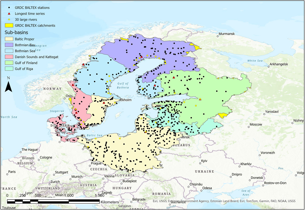
Figure 1. Map showing the catchment of the Baltic Sea and its sub-basins (see Table 1 for more details). Black dots mark the stations of the BALTEX dataset of GRDC, the red triangles mark stations with time series before 1900 and yellow dots represent 30 large rivers (see Table 2 for more details).
2.2 Data collection
The GRDC1, operating under the auspices of the World Meteorological Organization (WMO), has the aim of supporting and promoting research in the field of global and climate change as well as integrated water resources management. GRDC provides in situ river discharge time series, with daily or monthly resolution. To date, the total number of available stations in the database of GRDC has increased to nearly 11,000.
Since the integration of the BALTEX database into GRDC in 2015, the curation and update for the BALTEX dataset is embedded in the regular work of GRDC. Most of data is obtained from the National Meteorological and Hydrological Services (NMHS) of the WMO member states. The main quality-check is the responsibility of the NMHS, who provide the data. GRDC performs an outlier test and a visual quality-check prior to the inclusion into the GRDC database (Färber et al., 2024). If the NMHS provide only daily data, the mean monthly values are calculated by GRDC. Routinely, the data is requested each year. Where possible, data provision service via application programming interfaces (API) are used. With this approach, the number of stations in the Baltic Sea catchment area of the BALTEX dataset was expanded by 126 stations, receiving regular, up-to-date time series updates. Since not all countries have productive APIs, data provision is partly still delayed between 2 and 5 years, due to the time-consuming verification process. As soon as the data is available to GRDC, the data is provided to the user. An example of a daily time series available for download is presented in Figure 2.
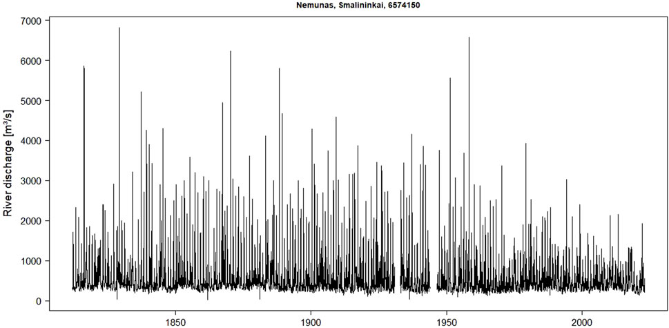
Figure 2. Daily time series of the Nemunas River, Smalininkai Station, GRDC No. 6574150, Lithuania. This is the longest available time series of daily data of the BALTEX dataset.
The time series data are available in various formats from the GRDC data portal2. The user can request the data for each station individually or by downloading the whole BALTEX dataset using the BALTEX catalogue provided at the GRDC website3 or using the metadata catalogue provided in the supplementary material (Supplementary Table S1). Together with the time series data, extensive metadata are attached to the files and catchment polygons for each of the stations are available. The BALTEX dataset is published under the GRDC data policy4 and WMO Resolution 25 (Cg-XIII-1999). Individual data licenses are reported in Supplementary Table S2.
To allocate the GRDC stations to the Baltic Sea catchment, the HELCOM GIS layer4 available at the HELCOM metadata catalogue, was used, which includes the Baltic Sea’s sub-basins drainage areas, aligning with Bergström and Carlsson (1994), resulting in a total of 718 stations.
3 Dataset description
Figure 1 shows the location of all GRDC stations that are included in the BALTEX dataset. Table 1 provides an overview of the number of stations in each sub-basin and their spatial and temporal coverage. There are 718 stations distributed across all sub-basins, which cover a total area of 1,737,019 km2 and fall within the range of the drainage area of the Baltic Sea mentioned above (see Chapter 2.1). The stations are equally distributed over the entire sub-basins upon availability. The GRDC station catchments cover in total 84% of the HELCOM basin layer. Important to note is that coastal areas are largely excluded and catchment areas are calculated for the location of the station.
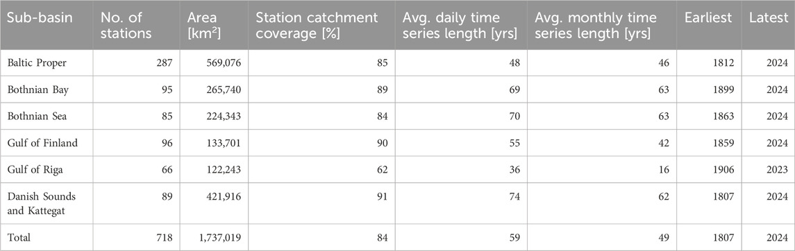
Table 1. Area of the sub-basins covered by the BALTEX dataset and average time series length.
One limiting factor for the spatial coverage of the dataset is that GRDC avoids to include stations that are influenced by tides. Therefore, stations directly at the river mouth are excluded, when they contain negative discharge or unreliable discharge values. Another factor is the inability to determine the station catchment area for 34 of the 718 stations, as certain catchments cannot be accurately represented by the elevation models used for catchment delineation. The methodology used to generate the GRDC station catchments is described in Färber et al. (2024).
Table 1 shows that the Baltic Proper has the highest station density, with a total of 287 stations, while in contrast, the Gulf of Riga has only 66 stations. All sub-basins have time series data available until 2024, except for the Gulf of Riga, which has records up to 2023. The oldest time series is in service since 1807, with a total of ten stations in the whole Baltic Sea catchment with data before 1900. The average daily time series length for all sub-basins is 59 years, while the average monthly time series length is 49 years. Therefore, most of the data covers the BALTEX active phase and beyond.
Figure 3 illustrates the availability of mean daily and monthly averages, represented in blue and light blue, respectively. As shown, a few time series reach back to the 19th century. These exceptionally long time series are also geographically well distributed (Figure 1), as indicated in the penultimate column of Table 1. Overall, the number of available time series increases until the mid-20th century, with a noticeable increase in the 1950s, largely due to the incorporation and data provision for many Polish time series during this period. Data availability peaks towards the late 20th century but steadily declines after 2000. The two observed peaks are due to time series from Lithuania and Belarus, covering short periods of 2 and 6 years, respectively.
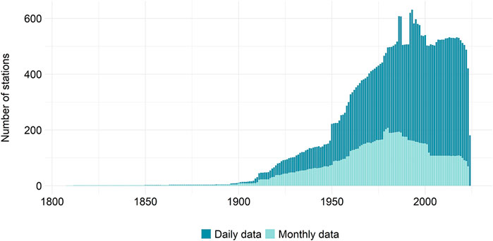
Figure 3. The number of stations in the BALTEX dataset, separated into daily and monthly time series.
4 Conclusion
The BALTEX database provides a viable source for river discharge data in the catchment area of the Baltic Sea. In the BALTEX dataset all available data is provided, even small catchments and short time series are included. In total, there are 718 stations with daily and monthly data available, ranging between 1 and 215 years, the catchment size ranges vary from sub-square kilometer up to 218,000 km2. Monthly time series are separated between original time series and calculated time series. The latter is calculated using daily averages. All of the sub-basins draining into the Baltic Sea are represented with different numbers of total stations. To date, this dataset is the most comprehensive dataset of river discharge data draining into the Baltic Sea. It is freely and unrestricted available.
Comparing the BALTEX dataset with available data is shown in Table 2. The datasets are in good agreement. As the original datasets of BMIP and BHDC are not available, small differences might occur due to a different selection of stations.
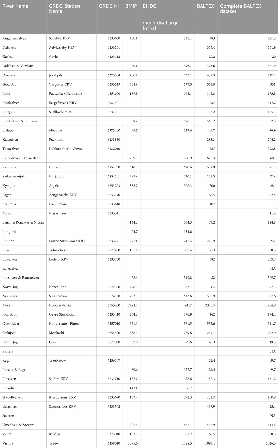
Table 2. Comparison of the mean discharge reported for BMIP and BHDC (Väli et al., 2019) and the BALTEX dataset for 1961-1990. In addition, the mean discharge for the complete available time for each individual station of the BALTEX dataset is provided.
Using the values from the BALTEX dataset and the 30 longest rivers allows the calculation of loads when combining the databases from other datasets, for example, from the Global Freshwater Quality Database GEMStat5,6.
Data availability statement
Publicly available datasets were analyzed in this study. This data can be found here: https://grdc.bafg.de/data/project_datasets/baltex/.
Author contributions
SAM: Validation, Data curation, Supervision, Methodology, Conceptualization, Writing – review and editing, Investigation, Resources, Writing – original draft, Visualization. CZ: Visualization, Writing – review and editing, Conceptualization, Writing – original draft. HP: Formal Analysis, Writing – review and editing, Software, Writing – original draft, Data curation.
Funding
The author(s) declare that financial support was received for the research and/or publication of this article. GRDC is funded by the Federal Institute of Hydrology, Germany (BfG).
Acknowledgments
GRDC thanks the World Meteorological Organization (WMO) and the Federal Institute of Hydrology, Germany (BfG) for support. The NMHS are acknowledged for providing their valuable data sets.
Conflict of interest
The authors declare that the research was conducted in the absence of any commercial or financial relationships that could be construed as a potential conflict of interest.
Generative AI statement
The author(s) declare that no Generative AI was used in the creation of this manuscript.
Publisher’s note
All claims expressed in this article are solely those of the authors and do not necessarily represent those of their affiliated organizations, or those of the publisher, the editors and the reviewers. Any product that may be evaluated in this article, or claim that may be made by its manufacturer, is not guaranteed or endorsed by the publisher.
Supplementary material
The Supplementary Material for this article can be found online at: https://www.frontiersin.org/articles/10.3389/fenvs.2025.1599188/full#supplementary-material
Footnotes
2https://grdc.bafg.de/data/data_portal/
3https://grdc.bafg.de/data/project_datasets/baltex/
4https://grdc.bafg.de/about/data_policy/
5https://metadata.helcom.fi/geonetwork/srv/eng/catalog.search#/metadata/9e132cda-8f69-4f7a-9c66-8b9859e61441
6GEMStat - The global water quality database
References
BALTEX (1994). Scientific plan for the Baltic sea experiment (BALTEX) ed. E. Raschke Geesthacht: GKSS Research Centre Geesthacht.
Bergström, S., and Carlsson, B. (1994). River runoff to the Baltic sea: 1950-1990. Ambio 23 (Nr. 4-5), 280–287. Available online at: http://www.jstor.org/stable/4314220
Donnelly, C., Anderson, J. C. M., and Arheimer, B. (2016). Using flow signatures and catchment similarities to evaluate the E-HYPE multi-basin model across Europe. Hyd Sci. J. 61, 2. doi:10.1080/02626667.2015.1027710
Färber, C., Plessow, H., Mischel, S., Kratzert, F., Addor, N., Shalev, G., et al. (2024). GRDC-Caravan: extending caravan with data from the global runoff data centre. Earth Syst. Sci. Data Discuss. doi:10.5194/essd-2024-427
HELCOM (2014). Convention on the protection of the marine environment of He Baltic sea are, 1992 (helsinki convention), HELCOM. Available online at: https://helcom.fi/wp-content/uploads/2019/06/Helsinki-Convention_July-2014.pdf (Accessed March 21, 2025).
HELCOM (2018). State of the Baltic sea – second HELCOM holistic assessment 2011-2016. Balt. Sea Environ. Proc. 155.
Kuliński, K., Rehder, G., Asmala, E., Bartosova, A., Carstensen, J., Gustafsson, B., et al. (2022). Biogeochemical functioning of the Baltic sea. Earth Syst. Dynam. 13, 633–685. doi:10.5194/esd-13-633-2022
Meier, H. E. M., Kniebusch, M., Dieterich, C., Gröger, M., Zorita, E., Elmgren, R., et al. (2022). Climate change in the Baltic sea region: a summary. Earth Syst. Dynam. 13, 457–593. doi:10.5194/esd-13-457-2022
Mikulski, Z. (1970). Inflow of river water to the Baltic sea in the period 1951-1960. Nord. Hydrol. 4, 216–227. doi:10.2166/nh.1970.0014
Nilsson, S. (2006). “International river basins in the Baltic sea region,”, III B. EU BSR INTERREG. Stockholm, Schweden: KTH, Royal Insitute of Technology.
Raschke, E., Meywerk, J., Warrach, K., Andrea, U., Bergström, S., Beyrich, F., et al. (2001). The Baltic sea experiment (BALTEX): a European contribution to the investigation of the energy and water cycle over a large drainage basin. Bull. Am. Meteorological Soc. 82, 2389–2413. doi:10.1175/1520-0477(2001)082<2389:tbseba>2.3.co;2
Reckermann, M., Langner, J., Omstedt, A., von Storch, H., Keevallik, S., Schneider, B., et al. (2011). BALTEX – an interdisciplinary research network for the Baltic sea region. Environ. Res. Lett. 6, 045205. doi:10.1088/1748-9326/6/4/045205
Keywords: baltic sea, river discharge, catchment areas, time series, in situ stations
Citation: Mischel SA, Zentis C and Plessow H (2025) The BALTEX dataset of the Global Runoff Data Centre (GRDC): a dataset of river discharge draining into the Baltic Sea. Front. Environ. Sci. 13:1599188. doi: 10.3389/fenvs.2025.1599188
Received: 24 March 2025; Accepted: 13 June 2025;
Published: 01 July 2025.
Edited by:
Agnieszka Jedruch, Polish Academy of Sciences, PolandReviewed by:
Jan Marcin Weslawski, Polish Academy of Sciences, PolandMarkus Meier, Leibniz Institute for Baltic Sea Research (LG), Germany
Copyright © 2025 Mischel, Zentis and Plessow. This is an open-access article distributed under the terms of the Creative Commons Attribution License (CC BY). The use, distribution or reproduction in other forums is permitted, provided the original author(s) and the copyright owner(s) are credited and that the original publication in this journal is cited, in accordance with accepted academic practice. No use, distribution or reproduction is permitted which does not comply with these terms.
*Correspondence: Simon A. Mischel, bWlzY2hlbEBiYWZnLmRl