 A. A. Kokhanovsky
- Department 1: Geodesy, Helmholtz Centre for Geosciences, Potsdam, Germany
The future trends in studies of environment and multi-dimensional global change are presented.
Current environmental problems related to the climatic changes, global temperature rise and anthropogenic pollution of atmosphere, ocean, rivers, lakes, soils and cryosphere are characteristic features of the multi - dimensional global change, which is the main feature of modern time. 2024 was the warmest year on the record (see Figure 1). If the trend shown in Figure 1 continues for the next decade, the multiple climate tipping points may be triggered (Armstrong McKay et al., 2022), which will lead to the increase of various hazard (fires, heatwaves and flooding) probabilities. The recent examples are fires in California (Madakumbura et al., 2025), devastating flooding in Valencia (https://edition.cnn.com/2024/10/30/world/video/spain-flash-flooding-ldn-digvid) and heatwaves in Europe (van Daalen et al., 2024). Currently, the world is heading toward 2°C–3°C of global warming by year 2100. The observed global warming leads to the increased speed of snow melting, the decrease in snow-covered area and snow duration, the increase in snow fragmentation (Gu et al., 2024), disappearance of glaciers, decrease in sea ice extent (https://seaice.uni-bremen.de/sea-ice-concentration/amsre-amsr2/time-series/), sea level rise, the degradation of the permafrost, catalyse widespread temporal turnover in biodiversity and intensification of various nonlinear feedbacks in the climate system including surface - atmosphere and aerosol - precipitation interactions (Swain et al., 2025). Two remote areas on our planet (Greenland and Antarctica) are characterised by the ice mass loss with possible abrupt changes (Siegert et al., 2023; Petrini et al., 2025), which may lead to the devastation in coastal areas around the globe. Our best and only way to protect these areas and the planet in a whole is decarbonize to net zero by 2050 (Siegert, 2024). Geoengineering efforts (Budyko, 1977; Crutzen, 2006) can not lead to the solution of the problem on the short time scale we face (till mid century). The environmental informatics or geoinformatics is an integrator of science, methods and techniques and not just the result of using information and software technology methods and tools for serving environmental engineering needs. Therefore, it plays a special and very important role in the modern environmental sciences. Clearly, without methods of the environmental informatics coupled with remote sensing, it could not be possible to prepare the results as shown in Figure 1, which are based on the huge databases and observational evidence. The record shown in Figure 1 confirms that we live in the epoch of rising temperatures. A part of current temperature records can be attributed to the natural factors such as the solar activity (see Figure 2). However, the oscillating total solar irradiance variation (Tchijevsky, 1970) can not explain the curve shown in Figure 1.
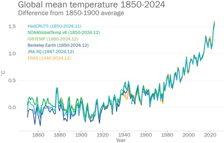
Figure 1. The temporal change of global mean temperature according to six different records (source: https://wmo.int/news/media-centre/wmo-confirms-2024-warmest-year-record-about-155degc-above-pre-industrial-level).
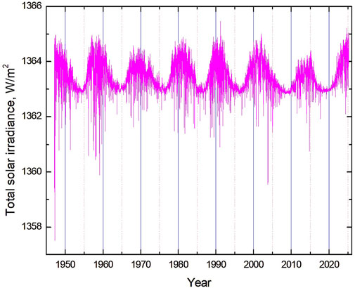
Figure 2. The daily variation of the total solar irradiance (Dewitte and Nevens, 2016; Dewitte et al., 2022).
Without doubt, one of the most important tasks of humankind at this stage is the preparation and implementation of measures to stop current warming trend. Otherwise, already in this century we may face disasters affecting not only flora and fauna but also humankind, especially in coastal areas, where the predicted sea rise is up to 1 m till 2100 (https://www.eea.europa.eu/en/analysis/indicators/global-and-european-sea-level-rise/observed-and-projected-change). The primary role in respect to climate change monitoring belongs to both ground-based and satellite remote sensing. The advanced spaceborne monitoring of our planet has been started a little more than half century ago. However, these efforts have already brought enormous progress in our understanding of atmosphere–underlying surface parameters and their temporal changes in conditions of current multi - dimensional global change (Kondratyev, 1998). Even more accurate and reliable results will be obtained by the mid-century with the planned launch of multiple satellite instrumentation operated in the UV, visible, NIR, SWIR and microwave regions of the electromagnetic spectrum including lidars, radars and hyperspectral instrumentation. The tremendous efforts put by the engineers and scientists in this direction can not be underestimated. In particular, The EUMETSAT Polar System–Second Generation (EPS-SG) and its Metop Second Generation (SG) satellites is one of the most complex and innovative low-Earth orbit meteorological satellites ever built. The system consists of two satellites working in tandem, each endowed with different suites of complementary instruments. Three successive pairs of Metop-SGA and Metop-SGB spacecraft will be deployed (from 2025), enabling full operational coverage and providing essential resource for climate monitoring, geoinformatics and global reanalysis till mid-century. The derived data will be used to inform policies and undertake actions to limit the negative effects of climate change on nature and humanity. The main features of the modern geoinformatics are the treatment of large amount of information (Big Data, e.g., coming from EPS-SG satellites), and the growing usage of the efficient computing, neural networks, and the Artificial Intelligence (AI) (Zhang and Zhang, 2022) including machine learning (Zhao et al., 2025), computational intelligence, data mining, and natural language processing (Bungartz et al., 2018). Taking into account resources put in these areas of research, a huge progress is expected in next decades leading to a better understanding of environment and its changes on various temporal and spatial scales, which is an important information for the decision makes and environment protection agencies worldwide. A special role in climate change studies belongs to the international cooperation and further development of the Global Climate Observing System (GCOS) (https://gcos.wmo.int/site/global-climate-observing-system-gcos) co-sponsored by the World Meteorological Organization (WMO), the Intergovernmental Oceanographic Commission of the United Nations Educational, Scientific and Cultural Organization (IOC-UNESCO), the United Nations Environment Programme and the International Science Council. The launch of the coordinated network of multiple geostationary satellites surveying the Earth as the whole at a given moment in time and the development of the self-organising satellite constellations, which enable satellites to autonomously cluster over Earth-surface targets (Mushet et al., 2015) is an important future exploration area. As it was underlined by Vernadsky (1926) a century ago, life is a geological force that changes Earth’s landforms, its climate, and the contents of its atmosphere. It is time to take a part of this force related to human activities under control - long before time, when it is too late. In this way together human reason and scientific thought will continue to create the next evolutionary geological layer (Teilhard de Chardin, 1966; Vernadsky, 1991; Vernadsky, 2001). As said Teilhard de Chardin (1966), “The Age of Nations is past. The task before us now, if we would not perish, is to build the Earth”.
Data availability statement
Requests to access the datasets should be directed to A. A. Kokhanovsky.
Author contributions
AK: Conceptualization, Writing – review and editing, Investigation, Methodology, Visualization, Writing – original draft.
Funding
The author(s) declare that no financial support was received for the research and/or publication of this article.
Conflict of interest
The author declares that the research was conducted in the absence of any commercial or financial relationships that could be construed as a potential conflict of interest.
The author(s) declared that they were an editorial board member of Frontiers, at the time of submission. This had no impact on the peer review process and the final decision.
Generative AI statement
The author(s) declare that no Generative AI was used in the creation of this manuscript.
Publisher’s note
All claims expressed in this article are solely those of the authors and do not necessarily represent those of their affiliated organizations, or those of the publisher, the editors and the reviewers. Any product that may be evaluated in this article, or claim that may be made by its manufacturer, is not guaranteed or endorsed by the publisher.
References
Armstrong McKay, D. I., Staal, A., Abrams, J. F., Winkelmann, R., Sakschewski, B., Loriani, S., et al. (2022). Exceeding 1.5°C global warming could trigger multiple climate tipping points. Science 377, eabn7950. doi:10.1126/science.abn7950
Bungartz, H. J., Kranzlmüller, D., Weinberg, V., Weissmüller, J., and Wohlgemuth, V. (2018). in Advances and new trends in environmental informatics (Berlin: Springer).
Crutzen, P. J. (2006). Albedo enhancement by stratospheric sulfur injections: a contribution to resolve a policy dilemma? Clim. Change 77, 211–220. doi:10.1007/s10584-006-9101-y
Dewitte, S., J Cornelis, J., and a Meftah, M. (2022). Centennial total solar irradiance variation. Remote Sens. 14, 1072. doi:10.3390/rs14051072
Dewitte, S., and Nevens, S. (2016). The total solar irradiance climate data record. ApJ 830, 25. doi:10.3847/0004-637X/830/1/25
Gu, J., Ma, Y., Zhang, L., Huang, Y., Zhang, W., Zhang, F., et al. (2024). Spatio-temporal variation in snow cover area and its fragmentation in Northeast China. Front. Earth Sci. 12, 1465071. doi:10.3389/feart.2024.1465071
Madakumbura, G., Thackeray, C., Hall, A., Williams, P., Norris, J., and Sukhdeo, R. (2025). Climate change a factor in inprecedented LA fires. Available online at: https://sustainablela.ucla.edu/2025lawildfires (Accessed March 21, 2025).
Mushet, G., Mingotti, G., Colombo, C., and Mcinnes, C. (2015). Self-organising satellite constellation in geostationary Earth orbit. IEEE Trans. Aerosp. Electron. Syst. 51 (2), 910–923. doi:10.1109/TAES.2014.130690
Petrini, M., Scherrenberg, M. D. W., Muntjewerf, L., Vizcaino, M., Sellevold, R., Leguy, G. R., et al. (2025). A topographically controlled tipping point for complete Greenland ice sheet melt. Cryosphere 19, 63–81. doi:10.5194/tc-19-63-2025
Siegert, M. (2024). How we know Antarctica is rapidly losing more ice. Bul. Atomic Sci. 80, 239–245. doi:10.1080/00963402.2024.2364507
Siegert, M., Bentley, M. J., Atkinson, A., Bracegirdle, T. J., Convey, P., Davies, B., et al. (2023). Antarctic extreme events. Front Env. Sci. Interdiscip. Clim. Stud. 11. doi:10.3389/fenvs.2023.1229283
Swain, B., Vountas, M., Singh, A., Anchan, N. L., Malasani, C. R., Mallick, D., et al. (2025). Insights of aerosol-precipitation nexus in the central Arctic through CMIP6 climate models. npj Clim. Atmos. Sci. 8, 103. doi:10.1038/s41612-025-00957-6
van Daalen, K. R., Tonne, C., and Semenza, J. C. (2024). The 2024 Europe report of the Lancet countdown on health and climate change: unprecedented warming demands unprecedented action. Lancet Public Health 9, 495–522. doi:10.1016/S2468-2667(24)00055-S2468-2667(24)00055-0
Vernadsky, V. I. (2001). Some words about the noosphere: hemical structure of the biosphere of the Earth and its environment. Moscow: Nauka. In Russian.
Zhang, L., and Zhang, L. (2022). Artificial intelligence for remote sensing data analysis: a review of challenges and opportunities. IEEE Geoscience Remote Sens. 10 (2), 270–294. doi:10.1109/MGRS.2022.3145854
Keywords: geoinformatics, climate change, environmnetal monitoring, satellite, earth
Citation: Kokhanovsky AA (2025) Environmental informatics and remote sensing: modern trends in studies of environment and multi-dimensional global change. Front. Environ. Sci. 13:1607253. doi: 10.3389/fenvs.2025.1607253
Received: 07 April 2025; Accepted: 02 May 2025;
Published: 16 May 2025.
Edited by:
Martin Siegert, University of Exeter, United KingdomReviewed by:
B. Herawan Hayadi, Bina Bangsa University, IndonesiaYuncong Li, University of Florida, United States
Copyright © 2025 Kokhanovsky. This is an open-access article distributed under the terms of the Creative Commons Attribution License (CC BY). The use, distribution or reproduction in other forums is permitted, provided the original author(s) and the copyright owner(s) are credited and that the original publication in this journal is cited, in accordance with accepted academic practice. No use, distribution or reproduction is permitted which does not comply with these terms.
*Correspondence: A. A. Kokhanovsky, YWxleGFuZGVyLmtva2hhbm92c2t5QGdmei1wb3RzZGFtLmRl