 Xiaomei Xiao1
 Mo Wang
- 1College of Horticulture and Landscape Architecture, Fujian Vocational College of Agriculture, Fuzhou, China
- 2College of Architecture and Urban Planning, Guangzhou University, Guangzhou, China
- 3Art School, Hunan University of Information Technology, Changsha, China
Rural landscape quality assessments are crucial for sustainable development, particularly in the context of China’s rural revitalization strategy. This study delineates the integration of the Analytic Hierarchy Process (AHP) and System Dynamics (SD) within a symbiotic framework to assess rural landscape quality, using Pingpan Village as a case study. The research highlights the importance of focusing on symbiotic environmental factors and demonstrates how such a focus enhances the integration of ecological, cultural, and functional elements essential for the sustainability and resilience of rural communities. By employing AHP, the study systematically quantifies and weights diverse landscape features, while SD captures the temporal and psychological dimensions of visitor experiences. The results reveal that ecological quality is the highest-scoring indicator, with a composite score of 0.6190, categorizing the landscape quality as satisfactory. However, areas such as landscape dynamism and functional diversity require significant improvement. This study provides an important framework for policymakers and planners aiming to enhance rural sustainability, emphasizing the integration of diverse landscape components. Future research should explore its application across various rural settings and incorporate advanced technologies like GIS for improved assessment precision.
1 Introduction
Amid the progressive implementation of China’s rural revitalization strategy, the comprehensive evaluation of rural landscape quality has emerged as a critical dimension in the pursuit of sustainable rural development and the long-term resilience of rural territories (Liu et al., 2019; Su et al., 2022). The rural landscape is a multifaceted entity that intertwines natural ecosystems, cultural heritage, and socio-economic functions, wherein the cultural and social dimensions are central to shaping the identity of rural communities. These dimensions influence not only the aesthetic and functional qualities of the landscape but also community cohesion, identity, and resilience in the face of social and economic changes. Its configuration and quality significantly influence ecological stability, biodiversity conservation, and environmental sustainability (Rescia et al., 2025). Concurrently, rural landscapes serve as repositories of intangible cultural assets and traditional knowledge systems, while also functioning as platforms for economic revitalization through agriculture, rural tourism, and cultural industries (Duran and Rey, 2022; Su et al., 2023). Given these diverse dimensions, assessing rural landscape quality requires an integrative approach that transcends traditional sectoral analyses.
Within this multifaceted context, symbiosis theory offers a valuable conceptual and analytical framework by elucidating the interdependent, reciprocal, and co-evolutionary relationships among the constituent elements of the rural landscape (Zhou et al., 2025b). The theory emphasizes the necessity of examining rural systems not as isolated components, but as dynamic and adaptive wholes, wherein natural, cultural, and functional elements are interconnected through mutualistic and synergistic interactions (Niu et al., 2023; Shen et al., 2025). Through the integration of key constructs such as symbiotic units (i.e., landscape components with distinct ecological or cultural roles), symbiotic environments (i.e., spatial and environmental contexts that enable mutual interactions), symbiotic interfaces (i.e., zones or mechanisms of interaction), and symbiotic models (i.e., configurations and operational patterns), a comprehensive symbiotic system can be conceptualized and analyzed (Long et al., 2009). This framework allows a more holistic understanding of rural landscapes and supports the sustainable integration of these elements.
Extant literature in this domain predominantly concentrates on industrial ecology and sustainable system development, with a particular focus on inter-industrial collaboration and the circular utilization of resources (Liu et al., 2025). Parallel to these industrial applications, scholars have increasingly turned their attention to the coordination and valuation of health indicators in urban and watershed systems. For instance (Li C. et al., 2024), investigated the degree of symbiotic coordination within urban agglomerations, while Sun and Wang (2023) quantified the health and symbiotic coordination capacity of the Yellow River basin. Similarly, Xiong et al. (2024) assessed the synergetic contributions of riverine health from a symbiotic framework.
Methodologically, the integration of system dynamics (SD) and scenario analysis has become prevalent for modeling the temporal evolution of symbiotic systems (Putra et al., 2024). For example, Wang Z. L. et al. (2025) employed SD simulations to explore the reuse potential of idle rural homesteads. Concurrently, interdisciplinary inquiries have gained momentum. Eddleston and Jennings (2024) examined the nexus between family enterprises and educational systems, elucidating their implications for sustainability, while Li (2010) analyzed the structural pathways of industry-education integration within vocational training frameworks.
The practical application of symbiosis theory has increasingly permeated various dimensions of rural planning, demonstrating both its conceptual adaptability and theoretical resilience. Originally rooted in biological systems, the theory has been successfully transposed into the spatial and socio-economic domains of rural development, where it provides a holistic framework for managing the complex interactions among ecological, cultural, and functional components. In peri-urban and rural interface zones, for example, symbiosis theory has been employed to mediate the tensions between urban expansion and ecological conservation, promoting spatial configurations that maintain environmental integrity while accommodating controlled growth (Guo et al., 2019). Similarly, in the conservation and revitalization of traditional settlements, the theory facilitates the reconciliation of heritage preservation with the functional modernization of rural spaces, enabling the co-existence of historical identity and contemporary livelihood needs (Shi et al., 2022).
Furthermore, the theoretical underpinnings of symbiosis have guided the planning and implementation of integrated rural complexes, wherein agriculture, tourism, ecological stewardship, and public services are synergistically embedded within multifunctional development models (Sun and Zhao, 2017). This approach reflects a shift from single-purpose land use planning toward systems-oriented rural regeneration. In the realm of artistic and cultural revitalization, symbiosis theory informs strategies that combine aesthetic interventions with the preservation of vernacular culture, thereby reinforcing cultural continuity while enhancing spatial quality and rural identity (David, 2011).
Symbiosis theory offers a comprehensive framework for understanding the intricate, interdependent relationships within rural landscapes, where ecological, cultural, and functional elements must coexist in a balanced and mutually beneficial manner (An et al., 2025; Wang P. et al., 2025). Unlike traditional frameworks that often isolate these components, symbiosis theory emphasizes their interconnectedness, making it particularly suitable for rural contexts where sustainability depends on the integration of these diverse elements. As the foundational theory for rural landscape assessment, symbiosis theory provides an effective lens through which the complex interactions among ecological, cultural, and functional components can be interpreted. By focusing on the mobilization of internal resources—whether ecological, cultural, or human—and promoting the spatial coordination of the “production–living–ecological” nexus, this theory facilitates the development of self-sustaining, context-specific pathways for rural development. In contrast to alternative frameworks that may overlook dynamic interrelationships, symbiosis theory offers a holistic, adaptive approach that addresses the evolving needs of rural areas. For example, in rural tourism communities, symbiosis theory has been applied to examine the restructuring of stakeholder relationships, advocating for participatory governance and equitable benefit-sharing to ensure long-term sustainability and local empowerment (Li Y. A. et al., 2024). Furthermore, in targeted poverty alleviation programs, symbiosis theory provides a multi-scalar perspective, integrating collaborative governance, cultural-ecological resilience, and long-term capacity building to enhance the structural robustness and adaptive capacity of rural development initiatives.
In recent years, methodological innovations such as the Analytic Hierarchy Process (AHP) and SD modeling have been increasingly adopted to analyze multifunctional land use patterns and the co-evolutionary dynamics of rural systems (Shang, 2012; Xi and Poh, 2015). AHP has proven effective in structuring hierarchical evaluations and deriving weightings based on expert judgment, thereby providing quantitative assessments of landscape components. Concurrently, SD modeling has enabled researchers to simulate feedback loops and temporal dynamics within human–environment systems, offering valuable insights into non-linear interactions and emergent behaviors in rural contexts (Hanf et al., 2025; Long et al., 2009). However, despite the individual strengths of these approaches, their combined application under a unified theoretical framework, such as that provided by symbiosis theory, remains underdeveloped.
Existing studies tend to apply AHP and SD as separate methodologies, often lacking a coherent conceptual bridge that links the static, expert-derived priorities of AHP with the dynamic, system-level modeling capabilities of SD. This disjunction limits the capacity to fully capture the multifactorial and evolving nature of rural landscapes. Furthermore, critical aspects such as cultural continuity, community engagement, and social structures are often underrepresented or excluded, leading to models that inadequately reflect the integrative nature of rural revitalization. The absence of a comprehensive, symbiosis-oriented methodological framework hinders the diagnostic depth of landscape assessments and the effectiveness of planning interventions for sustainable rural transformation (Swetnam et al., 2017).
Against this backdrop, the present study proposes a novel evaluation framework grounded in symbiosis theory and enriched through the integration of AHP and SD methodologies. Using Pingpan Village in Fujian Province as a representative case, this research constructs a multidimensional assessment index system encompassing symbiotic units, environment, interfaces, and models. The objective is to deliver a rigorous, systematic, and objective appraisal of rural landscape quality, thereby informing targeted strategies for sustainable rural optimization.
2 Materials and methods
2.1 Study case overview
Situated at an elevation exceeding 400 m, Pingpan Village is strategically located within the mountainous landscape of Baisha Town in Hanjiang District, Putian City, China. Characterized by its distinctive central plateau and extensive rapeseed fields—which have earned it the nickname “Little Wuyuan”—the village presents a picturesque and ecologically vibrant rural setting. In recent years, Pingpan Village has undergone substantial transformation through the coordinated integration of rural tourism initiatives and loquat agriculture development. This process has led to significant enhancements in local transportation infrastructure, public amenities, and tourism-related facilities, markedly improving the residents’ quality of life while simultaneously strengthening economic vitality. Beyond its scenic appeal, Pingpan Village epitomizes the contemporary dynamics of rural revitalization occurring in southeastern China, where traditional settlement patterns and cultural landscapes are increasingly reshaped through tourism-driven strategies. The village’s evolution from a subsistence-based community to a multifunctional tourism hub exemplifies broader spatial and socio-economic restructuring trends. Furthermore, its incorporation into national rural planning frameworks, emphasis on preserving tangible and intangible cultural heritage, and active grassroots involvement in landscape co-governance further underscore its value as a representative and robust case study for the application of the proposed symbiosis-based evaluation framework.
2.2 Analytic Hierarchy Process
2.2.1 Indicator weight assignment
This study integrates symbiosis theory as the foundational framework for selecting the twelve indicators used in rural landscape evaluation. Symbiosis theory, which emphasizes the interdependent and co-evolutionary relationships among ecological, cultural, and functional elements, provides a robust theoretical basis for these indicators. Each indicator was selected to reflect the interconnectedness of ecological health, cultural integrity, and functional diversity, aligning with the symbiotic principle that sustainable rural landscapes must balance and integrate these three dimensions. To ensure balanced representation across these sustainability pillars, the AHP was employed to structure the weighting of the indicators. A panel of experts, selected based on rigorous criteria, provided the necessary depth of evaluation, bringing expertise in fields such as landscape ecology, rural planning, cultural heritage management, and sustainable development. This multidisciplinary approach ensured a comprehensive understanding of the diverse factors shaping sustainable rural landscapes.The expert panel was guided through a systematic process to prioritize the indicators within each pillar, ensuring no single dimension dominated the others. Through structured discussions and iterative pairwise comparisons, experts evaluated the interdependencies and relative significance of the sustainability pillars. A judgment matrix was constructed, and the weights were derived using the eigenvector method, reflecting symbiosis theory’s emphasis on the integrated and balanced approach necessary for sustainable rural landscape planning. The consistency of the matrix is verified through the Consistency Ratio (CR), with a CR below 0.1 indicating acceptable consistency. To maintain a balanced approach, the pairwise comparisons across objectives, criteria, and sub-criteria were designed to reflect the equitable importance of all sustainability pillars. These calculations are performed using a 1–9 scaling system, and the results are structured into a square judgment matrix. The details of the indicator framework and their definitions are provided in Table 1.
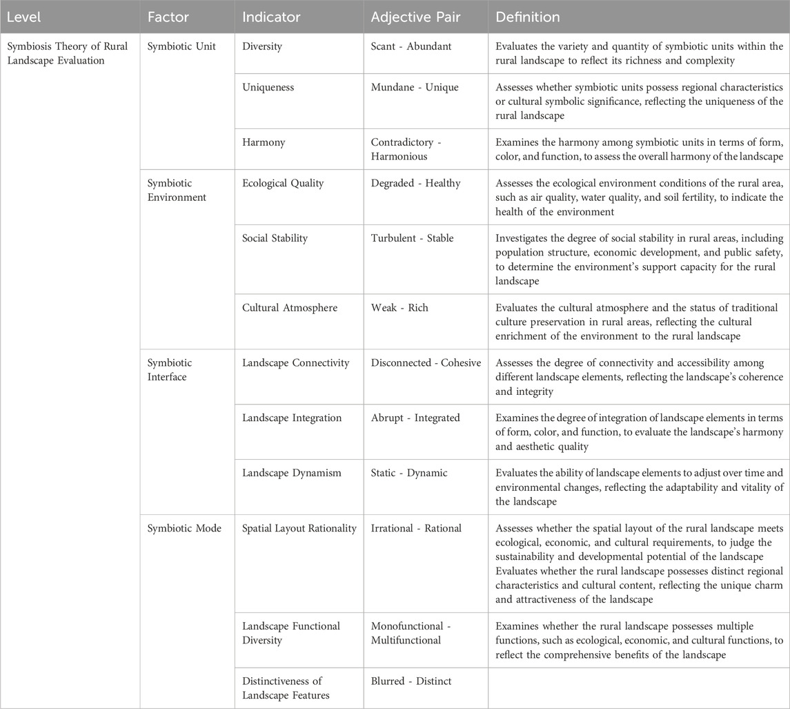
Table 1. Symbiosis theory-based rural landscape evaluation system.
In the AHP process, experts from diverse disciplines, including landscape ecology, rural planning, and sustainable development, were selected based on their academic credentials and practical experience in rural landscape assessments. While this expert-based, top-down approach provides valuable insights, it may also introduce subjectivity and bias in the weighting of indicators. To enhance representativeness and minimize potential biases, future research could incorporate a bottom-up, participatory approach. In such an approach, local communities, visitors, and other relevant stakeholders would be actively engaged in the pairwise comparisons, ensuring that the priorities reflect a broader range of perspectives and lived experiences. This would contribute to a more comprehensive and balanced evaluation process.
2.2.2 Construction and resolution of the judgment matrix
The process of determining criterion weights in the AHP relies on constructing a judgment matrix, which compares the importance of each evaluation indicator (Figure 1). This matrix allows experts to express their judgments about the relative importance of the criteria. To calculate the weights, two main methods are used: the square root method (also known as the geometric mean method) and the summation method. The square root method calculates the average value of each row in the matrix and normalizes the results. The summation method adds up the values in each row and then normalizes them by dividing by the total sum of all values. Both methods are effective in translating expert judgments into numerical values that reflect the importance of each criterion. The weights derived from these methods are then normalized so that they sum to one, ensuring that all criteria are compared on the same scale. This step is crucial for making meaningful comparisons and integrating the weights into further stages of decision-making. Specifically, for each indicator, all comparison values assigned to it are multiplied together, and then the nth root is taken, where n is the total number of indicators. These geometric means are then normalized by dividing each by the sum of all indicators’ geometric means, ensuring that the sum of all weights equals one. This process can be expressed mathematically as:
where
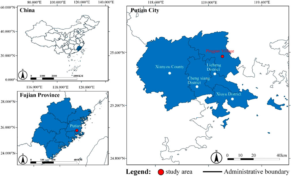
Figure 1. Study area.
To validate the logical coherence and internal consistency of the pairwise judgments, a consistency check is performed, typically involving the computation of the Consistency Index (CI) and the Consistency Ratio (CR). The CR, defined as the ratio of the CI to the corresponding Random Consistency Index (RI), is used to assess the acceptability of the judgment consistency. A CR value less than 0.10 is generally considered indicative of an acceptable level of consistency, thereby affirming the reliability of the weight derivation process. Should the CR exceed this threshold, it suggests significant inconsistencies in the input judgments, warranting a re-evaluation of the matrix. This step is critical for ensuring the methodological rigor and analytical robustness of the AHP-based evaluation framework.
2.3 System dynamics approach
The SD method, originally developed by Forrester, provides a robust framework for analyzing the structure, feedback loops, and temporal evolution of complex systems. In contrast to static evaluation methods, SD emphasizes the causal interrelationships, accumulations, flows, delays, and nonlinear interactions that govern system behavior over time. Its applicability extends across ecological, socio-economic, and management systems where dynamic complexity and feedback dominance prevail. Within the context of rural landscape evaluation, SD facilitates the modeling of how ecological quality, cultural atmosphere, and functional diversity dynamically interact and evolve under the influence of policy interventions, resource allocations, and visitor behavior. In this study, while empirical visitor perceptions were collected via a 7-point Likert scale, these data serve as parameter inputs for constructing and validating the SD model that represents the evolving quality of the rural landscape system. This distinction ensures that subjective perceptions are systematically incorporated into a dynamic modeling framework that captures both the psychological and temporal dimensions of landscape experiences.
A visitor survey was conducted utilizing a System Dynamics approach to capture visitors’ psychological and temporal perceptions of the landscape quality at Pingpan Village. The survey aimed to assess tourist satisfaction across twelve evaluation factors, employing a seven-point Likert scale ranging from “very satisfied” (+3) to “very dissatisfied” (−3). A total of 120 questionnaires were distributed during the data collection phase, which was conducted between July and August 2024, resulting in 86 valid responses and a response rate of 71.7%. The sample exhibited substantial diversity, capturing a broad representation of demographic characteristics. In terms of gender, the respondents included approximately 55% females and 45% males. Age distribution ranged from under 20 to over 60 years old, with the majority concentrated in the 21–40 age group. Occupational backgrounds were varied, encompassing students, employees from service industries, agricultural workers, and retirees. Geographically, the participants comprised both local residents of Pingpan Village and tourists originating from multiple urban centers across Fujian Province. Furthermore, the sample included both first-time visitors and repeat tourists, allowing for the capture of varying levels of familiarity with the rural landscape. The survey instrument focused on twelve key indicators aligned with the symbiosis theory framework, including ecological quality, landscape integration, cultural atmosphere, and functional diversity, thereby providing a comprehensive and multidimensional understanding of visitor perceptions toward the rural landscape quality.
This methodology is consistent with the System Dynamics approach, facilitating the modeling of dynamic interactions and temporal dimensions of the visitor experience. By increasing the transparency of the survey process and including detailed demographic information, the representativeness and credibility of the System Dynamics data collection are strengthened, ensuring that the survey results reflect a wide array of perspectives and experiences. To validate the SD model, the visitor survey data were compared with the model’s predicted landscape quality scores. The model’s accuracy was assessed by calculating the correlation between predicted and actual visitor satisfaction, with a Pearson correlation coefficient of 0.707* (p-value = 0.010), indicating a statistically significant alignment between the SD model and observed perceptions. This validation process helped refine the SD model’s responsiveness to the real-world dynamics of visitor experiences and ensured that the model effectively captured the psychological and temporal dimensions of landscape perceptions.
3 Results
3.1 Reliability and validity assessment
The initial phase of our analysis involved evaluating the reliability of the questionnaire data to determine the construct validity of the instrument employed. The results yielded a Cronbach’s alpha (α) of 0.829, surpassing the widely accepted threshold of 0.8, thereby confirming the high reliability and analytical robustness of the quality assessment questionnaire utilized in this study. Furthermore, the Pearson correlation coefficient between the AHP and SD methods registered at 0.707*, with a p-value of 0.010, significantly below the 0.05 threshold, indicating a statistically significant correlation and suggesting a robust inter-method consistency.
3.2 AHP derived weight scores
Data collated in Table 2 reveal the hierarchical scoring of symbiotic factors. The Symbiotic Environment achieved the highest score (0.4658), significantly outperforming the Symbiotic Interface (0.2771), Symbiotic Units (0.1611), and Symbiotic Models (0.096). In terms of specific indicators, Ecological Quality (0.2771) was predominant, followed sequentially by Landscape Integration (0.1626), Cultural Atmosphere (0.1288), and Landscape Connectivity (0.0897). Subsequent scores were attributed to Diversity (0.0897), Social Stability (0.0599), Coordination (0.0516), Rationality of Spatial Layout (0.0504), with lesser scores allocated to Distinctiveness of Landscape Features (0.0320), Landscape Dynamics (0.0247), Uniqueness (0.0198), and Functional Diversity of the Landscape (0.0136).
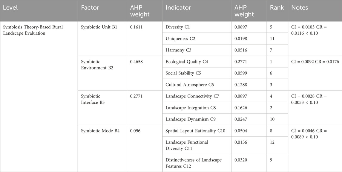
Table 2. Symbiosis theory-based evaluation of landscape quality weights in Pingpan village.
3.3 System dynamics indicator scores
As delineated in Table 3, the application of the SD method resulted in an average landscape evaluation score of 0.6616 post-visit to Pingpan Village, with a range spanning from −2.0531 to 2.8836. Notably, indices such as Ecological Quality, Landscape Integration, Cultural Atmosphere, Landscape Connectivity, Diversity, Social Stability, and Coordination all registered above the mean score, indicative of positive visitor perceptions. In contrast, scores for Rationality of Spatial Layout, Distinctiveness of Landscape Features, Landscape Dynamics, Uniqueness, and Functional Diversity of the Landscape were recorded below the average, reflecting areas of visitor dissatisfaction.

Table 3. System dynamics (SD) values for landscape quality evaluation in Pingpan village.
3.4 Composite scoring analysis
Integrating scholarly methodologies for rural landscape evaluation and combining AHP with SD, the study’s evaluative model quantified indicators to establish a composite score for Pingpan Village’s landscape. The composite scoring formula utilized is expressed as:
where
According to data in Table 4, the mean composite score for Pingpan Village’s landscape quality is 0.6190, classifying it within the ‘satisfactory’ category. At the factor layer, the Symbiotic Environment (0.5568) scored highest, underscoring a harmoniously integrated natural and ecological milieu surrounding Pingpan Village. Conversely, the Symbiotic Models (−0.1279) recorded the lowest score, signifying notable deficiencies in the village’s landscape developmental paradigms and symbiotic mechanisms.
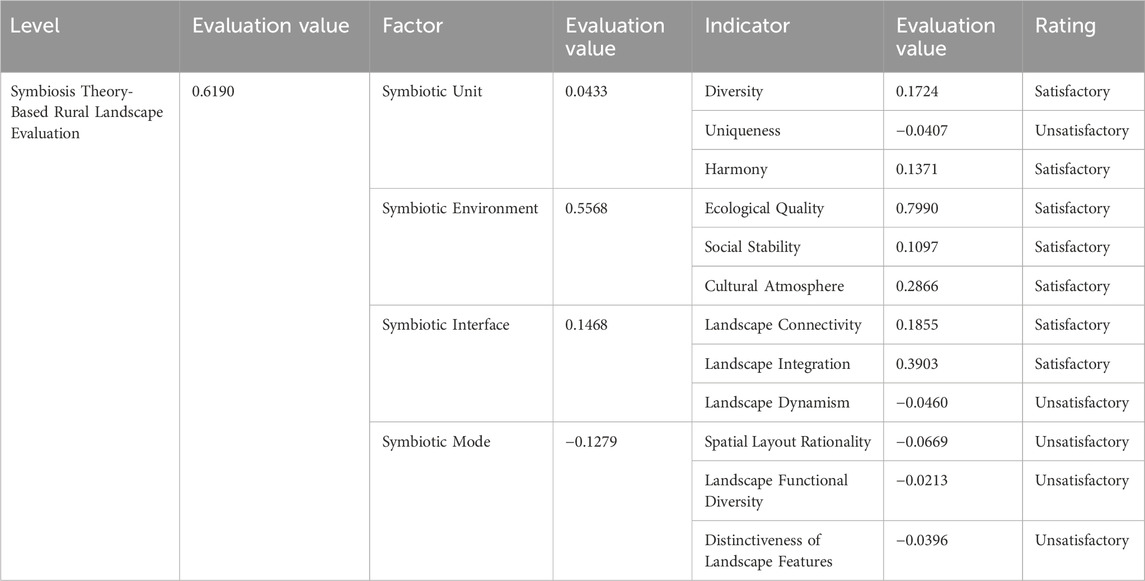
Table 4. Comprehensive evaluation of landscape quality in Pingpan village.
Figure 2 shows that parameters such as Ecological Quality (0.7990), Landscape Integration (0.3903), Cultural Atmosphere (0.2866), Landscape Connectivity (0.1855), Diversity (0.1724), Coordination (0.1371), and Social Stability (0.1097) achieved high scores, reflecting exemplary performance. However, Functional Diversity of the Landscape (−0.0213), Distinctiveness of Landscape Features (−0.0396), Landscape Dynamics (−0.0460), Uniqueness (−0.0407), and Rationality of Spatial Layout (−0.0669) were rated lower, pinpointing critical areas for potential enhancement.
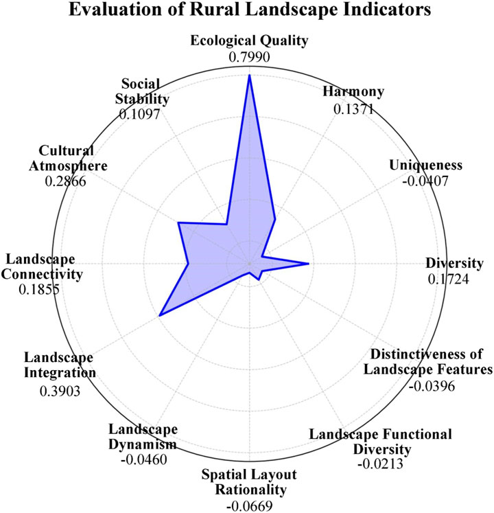
Figure 2. Evaluation of rural landscape indicators.
4 Discussion
This study highlights the importance of evaluating rural landscape quality using a symbiotic framework that integrates ecological, cultural, and functional dimensions. In the case of Pingpan Village, ecological quality scored highly at 0.7990, reflecting alignment with the “ecology-first” approach in rural planning. However, the findings reveal that ecological health alone does not guarantee the long-term sustainability of rural landscapes. Despite a strong ecological foundation, deficiencies in landscape dynamism and functional diversity were identified through System Dynamics analysis. These deficiencies point to a lack of flexibility and multifunctionality in the landscape, which are critical for fostering community resilience and economic vitality. Achieving sustainable rural landscapes requires not only ecological stability but also the incorporation of dynamic, multifunctional landscape elements. The results suggest that significant improvements are needed in areas like landscape dynamism and functional diversity. For policymakers, these insights highlight specific areas for targeted intervention. Strategies such as enhancing landscape dynamism through multifunctional spaces and promoting landscape diversity via agro-tourism and cultural landscape restoration could serve as key components of rural revitalization policies, ultimately strengthening both ecological integrity and economic resilience.
4.1 Augmentation of landscape functional diversity
The enhancement of landscape functional diversity represents a critical dimension in the sustainable development of rural territories, particularly within culturally and ecologically rich environments such as Pingpan Village. Situated within a scenic and historically significant rural context, Pingpan Village possesses the latent capacity to support multifunctional landscape planning that harmonizes ecological, cultural, and recreational functions. A key strategy for realizing this potential involves the systematic integration of leisure-oriented infrastructure—such as strategically located seating areas, pavilions, walking trails, and fitness installations—into the existing spatial fabric. These interventions are designed to accommodate a broad spectrum of user needs, including opportunities for rest, physical activity, social interaction, and scenic appreciation, thereby enhancing the landscape’s inclusivity and utility across demographic groups.
In addition to physical enhancements, the incorporation of experiential programming is essential to cultivating a vibrant and interactive rural environment (Zhou et al., 2025a). Initiatives such as hands-on agricultural experiences, artisanal craft workshops, culinary demonstrations, and live performances of local folk traditions not only enrich the visitor experience but also serve as vehicles for cultural transmission and rural identity preservation (Junge et al., 2011). These programs transform the rural landscape from a passive viewing environment into an active, participatory space that fosters knowledge exchange and cultural engagement.
A particularly promising avenue for expanding landscape functionality lies in the development of agrotourism models that capitalize on the region’s distinctive agricultural assets—most notably, Pingpan Village’s renowned loquat cultivation. The establishment of themed loquat orchards that facilitate fruit picking, seasonal festivals, and value-added processing experiences can strengthen place branding while simultaneously generating diversified revenue streams for local farmers and entrepreneurs (Putra et al., 2022). These agrotourism complexes serve as multifunctional nodes where agricultural production, tourism, education, and community engagement intersect, thus contributing to the rural economy’s resilience and vitality.
To accommodate the anticipated increase in tourism activities, the development of comprehensive public service infrastructure is imperative. This includes the construction of visitor information centers equipped with interpretive displays, the provision of sanitary and accessible public restrooms, the installation of shaded rest areas, and the expansion of parking facilities to ensure visitor convenience and safety (Xi and Poh, 2015). These functional upgrades not only address logistical requirements but also enhance the overall perception of Pingpan Village as a well-organized, visitor-friendly destination that aligns with national rural revitalization objectives. Ultimately, a holistic and integrative approach to spatial planning is required—one that synthesizes landscape design, cultural programming, and tourism service provision within a coherent development framework. Such an approach promotes the creation of adaptive, multifunctional rural spaces that are ecologically sustainable, economically productive, and socially inclusive. By embedding landscape function enhancement within a broader rural development strategy, Pingpan Village can serve as a replicable model for the functional transformation of traditional villages in China and beyond (Liu et al., 2022).
4.2 Amplification of landscape feature distinctiveness
The distinctiveness of rural landscapes is not only a reflection of their physical attributes but also a manifestation of their historical depth, cultural identity, and socio-spatial narratives. In the case of Pingpan Village, the amplification of landscape feature distinctiveness constitutes a vital strategy for reinforcing place identity and enhancing rural attractiveness in alignment with the broader objectives of cultural landscape conservation and rural revitalization. By systematically exploring and integrating the village’s rich historical and cultural heritage into the spatial and visual language of the landscape, a unique and recognizable cultural landscape can be constructed, serving both aesthetic and symbolic functions (Kang et al., 2021). To achieve this, landscape architectural interventions should prioritize the incorporation of culturally resonant and artistically refined elements. Sculptures depicting local folklore, murals narrating village history, and observation decks offering panoramic views can function as focal points within the spatial hierarchy of the landscape, thereby increasing its experiential richness and interpretive depth. Equally important are the micro-scale design details—such as customized paving patterns, contextually sensitive lighting systems, and locally inspired wayfinding signage—which collectively enhance both the aesthetic appeal and functional coherence of the landscape environment.
The visual identity of Pingpan Village should be further strengthened through the deliberate extraction and design translation of local “visualization elements.” These elements may include narratives from oral histories, intangible cultural heritage practices, and collective memories of long-time residents. For example, rest areas can be designed to resemble traditional farming implements, such as plowshares or loquat harvesting baskets, while decorative walls may feature collages of ancestral photographs, genealogy charts, and artisanal tools. Such design strategies not only elevate the visual character of the village but also foster an emotional and cognitive connection between visitors and the place, thereby deepening their understanding and appreciation of the local culture.
To ensure that the landscape’s distinctiveness remains dynamic and context-responsive, thematic programming should be integrated into the spatial and temporal rhythms of the village. Seasonal festivals, cultural exhibitions, and interactive performances—particularly during peak tourism periods—offer opportunities for the temporary reactivation of space, allowing the landscape to function as a living stage for cultural expression and community participation. These events, when aligned with the symbolic and spatial features of the landscape, can significantly enhance visitor engagement, increase the site’s cultural resonance, and contribute to the development of a vibrant rural tourism economy (Estalayo et al., 2021). Furthermore, the strategic dissemination of Pingpan Village’s unique landscape features through diverse media platforms—including digital marketing, heritage tourism networks, and academic collaborations—can significantly elevate its visibility within both national and international tourism circuits.
4.3 Innovation in fostering uniqueness
In the context of contemporary rural landscape planning, the pursuit of uniqueness must extend beyond the replication of traditional forms or reliance on conventional design paradigms. Instead, it necessitates a forward-looking approach that integrates technological innovation, artistic expression, and participatory co-creation. Within Pingpan Village, this strategic orientation toward innovation holds significant potential for establishing a landscape identity that is both distinctively local and globally relevant. The integration of advanced digital technologies—particularly augmented reality (AR) and virtual reality (VR)—offers transformative opportunities to enrich the visitor experience. These tools enable the layering of virtual content onto the physical environment, allowing users to interact with historical narratives, ecological processes, and cultural heritage in an immersive, multisensory format (Deep et al., 2025). For instance, visitors may engage with AR applications that reconstruct historical village scenes, interpret local flora and fauna, or animate folk legends in real time. Such interactive media broaden the interpretive depth of the landscape, catering to a diverse audience across age groups, linguistic backgrounds, and learning preferences, thereby enhancing educational value and recreational appeal. Simultaneously, the deliberate incorporation of contemporary public art—encompassing murals, sculptures, installations, and even curated graffiti—can activate public spaces with cultural dynamism and visual intrigue (Chatzidakis, 2016). These artistic expressions, when contextually grounded in local narratives and aesthetics, function not merely as decorative elements but as spatial catalysts that provoke reflection, stimulate dialogue, and generate emotional resonance. By departing from the homogeneity often observed in rural design, such interventions contribute to a more vibrant, expressive, and identity-rich landscape environment.
From a material and structural perspective, innovation can also be realized through the use of unconventional construction techniques and adaptive design systems. The application of modular, prefabricated, or responsive structures—such as kinetic installations or climate-sensitive pavilions—can introduce a forward-thinking aesthetic while enhancing functional adaptability (Klein et al., 2015). Moreover, utilizing locally sourced or recycled materials contributes to sustainability while simultaneously reinforcing the material authenticity of the built environment. These experimental design languages disrupt standardized rural aesthetics and signal a commitment to innovation, creativity, and environmental responsibility. Crucially, the success of such innovative approaches is contingent upon the sustained participation of local residents throughout the design, implementation, and management processes. Engaging community members not only ensures that indigenous knowledge systems, oral histories, and collective memories are embedded within the spatial narrative, but also fosters a deep sense of ownership, stewardship, and identity reinforcement (Picchi et al., 2023). Participatory design workshops, collaborative art projects, and capacity-building initiatives can serve as effective platforms for integrating local perspectives into landscape planning.
4.4 Enhancement of landscape dynamism
Landscape dynamism—defined as the capacity of a landscape to evolve temporally and respond to environmental, cultural, and user-driven changes—is a critical attribute in the design of contemporary rural environments. In the context of Pingpan Village, fostering such dynamism is essential to sustaining long-term attractiveness, ecological responsiveness, and user engagement. A dynamic rural landscape not only reflects the rhythm of natural cycles but also supports adaptive programming and interactive experiences, thereby maintaining the site’s vitality across different seasons and user demographics.
One of the foundational strategies for enhancing landscape dynamism involves the deliberate incorporation of seasonal vegetation, including flowering perennials, ornamental grasses, and deciduous tree species. These botanical selections are instrumental in creating a landscape palette that visibly transforms with the seasons, reinforcing the natural temporal rhythm and generating sensory richness throughout the year (Singh et al., 2020). Spring blooms, summer canopies, autumn foliage, and winter silhouettes collectively produce an ever-changing visual and experiential environment that invites repeated visitation and fosters emotional attachment. Complementing these ecological dynamics, the planning and execution of season-specific events—such as loquat harvest festivals, lantern exhibitions, or winter folk celebrations—can further enliven the rural space. These events not only animate the landscape temporally but also provide platforms for cultural expression, community participation, and economic stimulation through tourism and local enterprise. In addition to biotic and programmatic interventions, the integration of kinetic and interactive design elements significantly enhances the immersive quality of the landscape. Features such as water fountains, digital water screens, and programmable LED lighting installations introduce sensory dynamism that responds to environmental conditions, time of day, or visitor presence. These components serve not only as visual attractors but also as interactive media through which visitors engage more actively with the space, thereby deepening their overall experience and prolonging their stays.
Moreover, participatory and experiential design approaches further contribute to the creation of a responsive and memorable landscape. Activities such as do-it-yourself craft workshops, guided ecological walks, and interactive storytelling sessions provide opportunities for personalized engagement. These experiences facilitate cognitive and emotional connections between visitors and the landscape, enhancing both educational value and recreational satisfaction (Bierle and Singletary, 2008). However, the successful implementation of dynamic landscape features requires robust operational and maintenance strategies. A systematic framework for periodic renewal—encompassing both aesthetic and functional upgrades—is essential to preserve the quality and relevance of landscape components. This includes the timely replacement of seasonal plantings, technological updates to digital installations, and routine inspection of interactive infrastructure. Proactive maintenance not only sustains environmental and visual standards but also plays a crucial role in ensuring user safety, infrastructure longevity, and operational efficiency.
4.5 Optimization of spatial layout rationality
Spatial planning must begin with a thorough analysis of the village’s intrinsic landscape features, including its topography, vegetation, hydrology, and cultural assets. Functional zones—such as recreation spaces, scenic viewing points, ecological conservation areas, and service facilities—should be strategically delineated and distributed based on these site-specific characteristics and the behavioral patterns of various visitor groups (Tan et al., 2023). Such zoning enables the maximization of spatial efficiency while preserving the ecological and cultural integrity of the site.
A key consideration in this process is the integration of visual continuity and spatial accessibility, ensuring that each functional unit is cohesively linked within a broader spatial framework characterized by legibility, coherence, and experiential richness. Spatial transitions should be intuitively designed to guide users through a logically ordered sequence of landscapes, enhancing wayfinding and minimizing disorientation. Viewsheds, focal points, and visual corridors should be aligned to maintain scenic integrity and reinforce spatial connectivity across zones. Equally important is the scientific design of visitor flow routes, which must facilitate efficient movement, avoid bottlenecks, and accommodate peak periods of tourist activity (Shi et al., 2024). By adopting a hierarchical circulation system—comprising primary, secondary, and tertiary paths—visitor navigation can be streamlined to support diverse user itineraries and temporal rhythms. Strategic placement of nodes and rest areas along these routes can enhance comfort, distribute foot traffic, and improve the overall spatial experience.
The unique topographical features of Pingpan Village offer significant opportunities for the creation of a multi-tiered, three-dimensional landscape. By utilizing elevation changes and terrain morphology, planners can introduce vertical layering and spatial depth that enrich visual perception and ecological complexity. Terracing, stepped platforms, and elevated pavilions not only provide scenic vistas but also allow for differentiated spatial functions across altitude gradients, thereby increasing the landscape’s functional and aesthetic value. Crucially, all spatial interventions must be grounded in the principles of ecological conservation. This entails minimizing soil disturbance, protecting native vegetation, managing water runoff, and maintaining habitat connectivity throughout the design and implementation phases (Huang et al., 2022). Buffer zones should be incorporated to separate high-intensity use areas from sensitive ecological zones, while low-impact materials and construction methods should be prioritized. The promotion of biodiversity, preservation of local ecosystems, and reduction of anthropogenic stressors are fundamental to fostering a harmonious and resilient relationship between human activity and the natural environment (Zhang and Zhong, 2023).
4.6 Balancing ecological conservation and tourism development
Sustainable landscape planning prioritizes ecological conservation as a core element essential for maintaining ecosystem services and enhancing the resilience of rural landscapes. A critical strategy involves the establishment of ecological corridors, which enhance habitat connectivity, facilitate species migration, and protect landscapes from environmental stressors (Wang et al., 2024). These corridors play a vital role in linking fragmented habitats, thereby supporting biodiversity conservation despite land-use changes and climate variability. However, tourism development can place pressure on these ecosystems by increasing human activity in sensitive areas. Restoration efforts should focus on cultivating indigenous plant species, which are better suited to local conditions and help support native wildlife populations. In addition, preserving critical ecological habitats such as wetlands, riparian zones, and forest patches must be integrated into land-use planning to maintain ecosystem functions, while ensuring that tourism does not undermine these vital areas (Wang et al., 2023a).
Equally important is the role of sustainable tourism practices in mitigating the environmental impacts of increased visitor activity. Implementing low-impact infrastructure, regulating visitor flow, and adopting waste management protocols and eco-certification for local businesses are key strategies to reduce tourism’s ecological footprint (Adnan et al., 2025). However, there is often a trade-off between promoting tourism for economic gain and conserving ecological integrity. To address this, tourism development should adhere to ecological stewardship principles, ensuring economic benefits align with conservation goals. Interpretive signage, guided nature tours, and experiential learning programs can also help raise visitor awareness and promote responsible tourism practices. Furthermore, local community involvement is crucial for fostering long-term ecological stewardship. By engaging local residents in decision-making and management processes and implementing environmental education programs, communities can actively contribute to sustainable practices, including biodiversity conservation and waste reduction. This participatory governance approach not only enhances trust but also supports adaptive management and promotes localized innovation, ultimately reinforcing the resilience and sustainability of rural landscapes (Wang et al., 2023b).
5 Conclusion
This study presents a comprehensive evaluation of rural landscape quality by integrating the AHP and SD within a symbiotic framework, using Pingpan Village as a case study. The findings underscore the critical importance of conducting landscape evaluations through the lens of symbiotic relationships, facilitating the integration of ecological, cultural, and functional components within rural landscapes. By emphasizing the cultural and social dimensions, this research not only aligns with sustainable development goals but also contributes to the vitality and resilience of rural communities. Furthermore, the study strengthens social cohesion, reinforces cultural identity, and promotes long-term sustainability, thus offering a holistic approach to rural landscape management. The implementation of AHP enabled a systematic analysis of various landscape features, facilitating the quantification of qualitative aspects and ensuring a rigorous weighting of indicators. SD offered a dynamic perspective, capturing both the temporal and psychological dimensions of visitor experiences, thus providing a detailed perspective on landscape quality from a visitor-centric standpoint.
The high evaluation scores for ecological quality are in line with global sustainability trends and support the “ecology-first” approach prevalent in rural planning discussions. In contrast, the identification of areas requiring improvement, such as landscape dynamism and functional diversity, underscores the necessity for continuous innovation and adaptation in rural landscape management.
Although the integration of AHP and SD methodologies provides a robust framework for assessing rural landscapes, several limitations must be addressed. The reliance on expert judgment in the AHP process introduces subjectivity and potential bias in the weighting of indicators. To mitigate this, future research should broaden the stakeholder base to include local communities, visitors, and practitioners from diverse sectors, thereby ensuring a more inclusive and balanced representation of perspectives. Furthermore, to reduce uncertainty, methods such as fuzzy AHP or the Delphi technique should be considered to manage ambiguity in expert judgments more effectively. While the SD approach offers valuable insights into the dynamic interactions within rural landscapes, it faces challenges related to model simplification and parameter uncertainty. To improve the accuracy of SD simulations, future studies should incorporate sensitivity analysis and model calibration techniques. Despite the framework’s significant value for policymakers and planners, its generalizability remains constrained by the case study approach. Future research should apply the framework across diverse geographic contexts, such as arid, alpine, or coastal regions, to assess its robustness in various environments. The integration of big data analytics, including GIS-based behavior tracking and real-time environmental monitoring, could further enhance the framework’s precision and adaptability. Finally, conducting international comparative studies is recommended to evaluate the global applicability of symbiosis theory and refine rural landscape evaluation frameworks for broader use beyond China.
Data availability statement
The original contributions presented in the study are included in the article/supplementary material, further inquiries can be directed to the corresponding authors.
Author contributions
XX: Investigation, Writing – original draft, Software, Data curation, Conceptualization, Validation, Visualization, Methodology. JA: Writing – original draft, Validation. MW: Writing – review and editing, Writing – original draft. LW: Supervision, Conceptualization, Methodology, Validation, Writing – original draft, Formal Analysis, Funding acquisition, Resources, Software, Project administration.
Funding
The author(s) declare that financial support was received for the research and/or publication of this article. This research was funded by 2024 Hunan Provincial Department of Education Scientific Research Project (Key Project), grant number 24A0751, Guangzhou City School (Institute) Enterprise Joint Funding Project, China [grant number 2024A03J0317].
Conflict of interest
The authors declare that the research was conducted in the absence of any commercial or financial relationships that could be construed as a potential conflict of interest.
Generative AI statement
The author(s) declare that no Generative AI was used in the creation of this manuscript.
Publisher’s note
All claims expressed in this article are solely those of the authors and do not necessarily represent those of their affiliated organizations, or those of the publisher, the editors and the reviewers. Any product that may be evaluated in this article, or claim that may be made by its manufacturer, is not guaranteed or endorsed by the publisher.
References
Adnan, R. M., Mostafa, R. R., Wang, M., Parmar, K. S., Kisi, O., and Zounemat-Kermani, M. (2025). Improved random vector functional link network with an enhanced remora optimization algorithm for predicting monthly streamflow. J. Hydrology, 650, 132496. doi:10.1016/j.jhydrol.2024.132496
An, X. J., Meng, L. J., Zeng, X. T., and Ma, L. X. (2025). How urban-rural integration symbiosis can ameliorate the socioeconomic inequity in ecological space: evidence from Yunnan, China. Sustainability 17 (7), 2895. doi:10.3390/su17072895
Bierle, S., and Singletary, T. J. (2008). Environmental education and related fields in Idaho secondary schools. J. Environ. Educ. 39 (3), 19–31. doi:10.3200/joee.39.3.19-31
Chatzidakis, M. (2016). Street art conservation in Athens: critical conservation in a time of crisis. Stud. Conservation 61, 17–23. doi:10.1080/00393630.2016.1201757
David, B. (2011). Inbetween: cultural regeneration in market towns. Ukri. <Go ISI>://GRANTS, 15342539.
Deep, S., Vishnoi, S., Malhotra, R., Mathur, S., Yawale, H., Kumar, A., et al. (2025). Influence of augmented reality and virtual reality on real estate investment decisions: understand consumer perspective in Indian AEC industry. Eng. Constr. Archit. Manag. 32 (2), 1122–1140. doi:10.1108/ecam-04-2023-0327
Duran, A. M., and Rey, M. V. (2022). “Making our rural landscape visible. A way to defend anonymous cultural heritage,” in Coleccion congresos UPV [heritage 2022 international conference vernacular heritage:Culture, people and sustainability]. International conference on vernacular heritage: culture, people and sustainability (HERITAGE). Valencia, SPAIN.
Eddleston, K. A., and Jennings, J. E. (2024). Creating and sustaining mutualistic well-being: toward a theory of family and business symbiosis. J. Fam. Bus. Strategy 15 (3), Article 100636. doi:10.1016/j.jfbs.2024.100636
Estalayo, E., Aramendia, J., Bellot-Gurlet, L., Garcia, L., Garcia-Camino, I., and Madariaga, J. M. (2021). The interaction of sediments with the archeological iron remains from the recovery shipwreck of urbieta (gernika, north of Spain). J. Raman Spectrosc. 52 (1), 230–240. doi:10.1002/jrs.5944
Guo, L. Y., Di, L. P., and Tian, Q. (2019). Detecting spatio-temporal changes of arable land and construction land in the beijing-tianjin corridor during 2000-2015. J. Geogr. Sci. 29 (5), 702–718. doi:10.1007/s11442-019-1622-1
Hanf, F. S., Ament, F., Boettcher, M., Burgemeister, F., Gaslikova, L., Hoffmann, P., et al. (2025). Towards a socio-ecological system understanding of urban flood risk and barriers to climate change adaptation using causal loop diagrams. Int. J. Urban Sustain. Dev. 17 (1), 69–102. doi:10.1080/19463138.2025.2474399
Huang, Z. D., Jing, Z. P., Bai, Y., and Fang, Z. (2022). Does public environmental education and advocacy reinforce conservation behavior value in rural southwest China? Sustainability 14 (9), 5505. doi:10.3390/su14095505
Junge, X., Lindemann-Matthies, P., Hunziker, M., and Schüpbach, B. (2011). Aesthetic preferences of non-farmers and farmers for different land-use types and proportions of ecological compensation areas in the Swiss lowlands. Biol. Conserv. 144 (5), 1430–1440. doi:10.1016/j.biocon.2011.01.012
Kang, Y., Cho, N., Yoon, J., Park, S., and Kim, J. (2021). Transfer learning of a deep learning model for exploring tourists' urban image using geotagged photos. Isprs Int. J. Geo-Information 10 (3), 137. doi:10.3390/ijgi10030137
Klein, L. R., Hendrix, W. G., Lohr, V. I., Kaytes, J. B., Sayler, R. D., Swanson, M. E., et al. (2015). Linking ecology and aesthetics in sustainable agricultural landscapes: lessons from the palouse region of Washington, USA. Landsc. Urban Plan. 134, 195–209. doi:10.1016/j.landurbplan.2014.10.019
Li, F. L. (2010). A study on the present situation analysis and countermeasures of developing vocational education in minority regions of Hubei Province.
Li, Y. A., Ismail, M. A., and Aminuddin, A. (2024b). How has rural tourism influenced the sustainable development of traditional villages? A systematic literature review. Heliyon 10 (4), e25627. doi:10.1016/j.heliyon.2024.e25627
Li, C., Lin, S. J., Wang, Y. T., and Chen, L. D. (2024a). Evaluation of regional integration in urban agglomeration area from the perspective of urban symbiosis. Sustain. Cities Soc. 105, 105338. doi:10.1016/j.scs.2024.105338
Liu, C. F., Yu, B., Zhu, Y., Liu, L. C., and Li, P. J. (2019). Measurement of rural residents' mobility in Western China: a case study of qingyang, Gansu province. Sustainability 11 (9), Article 2492. doi:10.3390/su11092492
Liu, J. T., Ning, L. J., and Gao, Q. F. (2025). Research on the knowledge transfer mechanism of digital platform in the digital innovation ecosystem: an improved model of SIR embedded in symbiosis theory. Kybernetes 54 (1), 622–645. doi:10.1108/k-06-2023-0987
Liu, Z., Zhang, S. J., Li, L. L., Hu, B., Liu, R., Zhao, Z., et al. (2022). Research on the construction and prediction of China's national fitness development index system under social reform. Front. Public Health 10, 878515. doi:10.3389/fpubh.2022.878515
Long, H. L., Liu, Y. S., Wu, X. Q., and Dong, G. H. (2009). Spatio-temporal dynamic patterns of farmland and rural settlements in su–xi–chang region: implications for building a new countryside in coastal China. Land Use Policy 26 (2), 322–333. doi:10.1016/j.landusepol.2008.04.001
Niu, K. Y., He, W., and Qiu, L. Y. (2023). Symbiosis coordination between industrial development and ecological environment for sustainable development: theory and evidence. Sustain. Dev. 31 (4), 3052–3069. doi:10.1002/sd.2569
Picchi, P., Oudes, D., and Stremke, S. (2023). Regional strategy, municipality plans and site designs for energy transition in amsterdam, the Netherlands: how sustainable are implementation processes on different spatial levels? Sustainability 15 (7), 5876. doi:10.3390/su15075876
Putra, B. T. W., Indracahyana, K. S., and Al Fanshuri, B. (2022). Development of a handheld IoT-Based fruit harvester to support agrotourism. Microprocess. Microsystems 91, 104550. doi:10.1016/j.micpro.2022.104550
Putra, I. N., Octavian, A., Susilo, A. K., and Santosa, Y. N. (2024). Assessment of cyber resilience in the maritime domain using system dynamics and analytical hierarchy process (AHP). Trans. Marit. Science-Toms 13 (2). doi:10.7225/toms.v13.n02.w06
Rescia, A. J., Sousa, A. A. R., Sales, R. G., Ososrio, M. S., and Aguilera, P. A. (2025). The role of private landowners for generating cultural ecosystem services in mediterranean rural landscapes: a case study in Andalusia (spain). Ecosyst. People 21 (1). doi:10.1080/26395916.2025.2451289
Shang, H. Y. (2012). “Urban sustainable development evaluation based on system dynamic model.Advanced materials research [advances in environmental science and engineering, pts 1-6],” in 1st international conference on energy and environmental protection (ICEEP 2012). Hohhot: PEOPLES R CHINA.
Shen, H. H., Aziz, N. F., and Lv, X. Y. (2025). Using 360-degree panoramic technology to explore the mechanisms underlying the influence of landscape features on visual landscape quality in traditional villages. Ecol. Inf. 86, 103036. doi:10.1016/j.ecoinf.2025.103036
Shi, H. C., Yao, L. L., Liu, Q. Q., Wang, Y. K., Wei, Z. C., Zhao, M. X., et al. (2024). From trajectories to network: delineating the spatial pattern of recreational walking in guangzhou. Appl. Geogr. 170, 103344. doi:10.1016/j.apgeog.2024.103344
Shi, Y. L., Huang, Y., Zhang, R., Jiang, D., and Zhang, J. X. (2022). Adaptive renewal of mountainous historical towns based on the stability of the social network structure: a case study in chongqing, China. Front. Public Health 10, 867407. doi:10.3389/fpubh.2022.867407
Singh, A., Avis, W. R., and Pope, F. D. (2020). Visibility as a proxy for air quality in East Africa. Environ. Res. Lett. 15 (8), Article 084002. doi:10.1088/1748-9326/ab8b12
Su, K. C., Wu, J., Yan, Y., Zhang, Z. X., and Yang, Q. Y. (2022). The functional value evolution of rural homesteads in different types of villages: evidence from a Chinese traditional agricultural village and homestay village. Land 11 (6), 903. doi:10.3390/land11060903
Su, T. T., Wang, K. P., Li, S. S., Wang, X. Y., Li, H., Ding, H. R., et al. (2023). Analysis and optimization of landscape preference characteristics of rural public space based on eye-tracking technology: the case of huangshandian village, China. Sustainability 15 (1), 212. doi:10.3390/su15010212
Sun, Y. F., and Wang, N. L. (2023). An evaluation framework for industrial ecology based on the symbiosis theory-taking the π-shaped curve area in the yellow river of China as an example. Ecol. Indic. 154, 110468. doi:10.1016/j.ecolind.2023.110468
Sun, Z. B., and Zhao, D. P. (2017). “Research on low carbon construction and creative development in rural tourism development,” in Advances in social science education and humanities research [proceedings of 3rd international symposium on social science (isss 2017)]. 3rd international symposium on social science (ISSS). Dalian: PEOPLES R CHINA.
Swetnam, R. D., Harrison-Curran, S. K., and Smith, G. R. (2017). Quantifying visual landscape quality in rural Wales: a GIS-Enabled method for extensive monitoring of a valued cultural ecosystem service. Ecosyst. Serv. 26, 451–464. doi:10.1016/j.ecoser.2016.11.004
Tan, L., Luo, W., Yang, B., Huang, M., Shuai, S., Cheng, C. X., et al. (2023). Evaluation of landscape ecological risk in key ecological functional zone of south-to-north water diversion project, China. Ecol. Indic. 147, 109934. doi:10.1016/j.ecolind.2023.109934
Wang, M., Fu, X., Zhang, D., Chen, F., Liu, M., Zhou, S., et al. (2023a). Assessing urban flooding risk in response to climate change and urbanization based on shared socio-economic pathways. Sci. Total Environ., 880, 163470. doi:10.1016/j.scitotenv.2023.163470
Wang, M., Li, Y., Yuan, H., Zhou, S., Wang, Y., Adnan Ikram, R. M., et al. (2023b). An XGBoost-SHAP approach to quantifying morphological impact on urban flooding susceptibility. Ecol. Indic., 156, 111137. doi:10.1016/j.ecolind.2023.111137
Wang, M., Zhuang, J. A., Sun, C. H., Wang, L., Zhang, M. H., Fan, C. L., et al. (2024). The application of rain gardens in urban environments: a bibliometric review. Land 13 (10), 1702. doi:10.3390/land13101702
Wang, P., Guo, B., and Sun, Z. L. (2025a). Sustainable urban-rural symbiosis in China: a study from the symbiosis theory perspective on level measurement and spatial difference analysis. Sustainability 17 (7), 2790. doi:10.3390/su17072790
Wang, Z. L., Wang, C., Dou, H. J., Cheng, G. S., Zhang, J., Lei, X. Y., et al. (2025b). A strategy of building a beautiful and harmonious countryside: reuse of idle rural residential land based on symbiosis theory. Habitat Int. 155, Article 103238. doi:10.1016/j.habitatint.2024.103238
Xi, X., and Poh, K. L. (2015). A novel integrated decision support tool for sustainable water resources management in Singapore: synergies between system dynamics and analytic hierarchy process. Water Resour. Manag. 29 (4), 1329–1350. doi:10.1007/s11269-014-0876-8
Xiong, P. R., Zhu, J. W., He, R., and Li, H. (2024). Synergy assessment of river health values from a symbiotic perspective: a case study of the yellow river basin in China. Water 16 (1), 91. doi:10.3390/w16010091
Zhang, R. B., and Zhong, C. B. (2023). The establishment of the national key ecological functional zone and the county's ecological green development. Front. Ecol. Evol. 11. doi:10.3389/fevo.2023.1144245
Zhou, S., Diao, H., Wang, J., Jia, W., Xu, H., Xu, X., et al. (2025a). Multi-stage optimization framework for synergetic grey-green infrastructure in response to long-term climate variability based on shared socio-economic pathways. Water Res., 274, 123091. doi:10.1016/j.watres.2025.123091
Keywords: rural landscape assessment, symbiosis theory, analytic hierarchy process, system dynamics, sustainable rural development
Citation: Xiao X, Zhuang J, Wang M and Wang L (2025) A symbiosis theory-based strategic framework for rural landscape assessment: a case study utilizing AHP and system dynamics. Front. Environ. Sci. 13:1613364. doi: 10.3389/fenvs.2025.1613364
Received: 17 April 2025; Accepted: 16 June 2025;
Published: 24 June 2025.
Edited by:
Chong Jiang, Guangdong Academy of Science (CAS), ChinaReviewed by:
Ashutosh Shukla, University of the Ryukyus, JapanMojtaba Enayati, Amrita Vishwa Vidyapeetham, India
Haobing Wang, Jiangsu University of Science and Technology, China
Copyright © 2025 Xiao, Zhuang, Wang and Wang. This is an open-access article distributed under the terms of the Creative Commons Attribution License (CC BY). The use, distribution or reproduction in other forums is permitted, provided the original author(s) and the copyright owner(s) are credited and that the original publication in this journal is cited, in accordance with accepted academic practice. No use, distribution or reproduction is permitted which does not comply with these terms.
*Correspondence: Mo Wang, bGFuZHdhbmdtb0BvdXRsb29rLmNvbQ==; Lie Wang, d2FuZ2xpZTg2MTAwNTExMzhAb3V0bG9vay5jb20=