 Abdelkarim Hamrita1*
 Faouzi Haouala2†
 Khouloud Annabi1
 Rania Kouki1,3Mokhtar Rejili2†Bouthaina Al Mohandes Dridi1
- 1Laboratory of Agrobiodiversity and Ecotoxicology LR21AGR02, High Agronomic Institute of Chott Mariem, University of Sousse, Sousse, Tunisia
- 2Department of Biology, College of Sciences, Imam Mohammad Ibn Saud Islamic University (IMSIU), Riyadh, Saudi Arabia
- 3Higher Institute of Biotechnology of Monastir (ISBM), University of Monastir, Monastir, Tunisia
Introduction: This study investigates the evolution and transformation of vineyard landscapes in the Boukornine region of Tunisia, located near Boukornine National Park. The region exemplifies the growing tension between ecological sustainability, landscape heritage, and socio-economic development in Mediterranean viticultural systems. Increasing urbanization, climate variability, and the modernization of farming practices are reshaping these traditional landscapes.
Methods: A mixed-methods approach was employed, combining spatial analysis, semi-structured interviews with key stakeholders, and participatory governance models. The research was conducted within the framework of the OENOMED project, which promotes sustainable and inclusive development strategies in Mediterranean viticulture.
Results: Findings reveal a marked shift from traditional, biodiversity-rich vineyard systems to more intensive, mechanized models. This shift has contributed to landscape homogenization and a decline in ecological functionality. Nonetheless, the vicinity of Boukornine National Park provides critical ecosystem services—such as microclimate regulation and biodiversity support—that buffer vineyards against environmental stressors.
Discussion: The study emphasizes the need for sustainable transitions in vineyard management through the adoption of organic farming practices, efficient irrigation systems, and the valorization of local terroirs. It also underscores the value of participatory planning tools in fostering adaptive governance. The integration of ecological, cultural, and territorial dimensions is essential for building resilient vineyard landscapes in Mediterranean regions undergoing rapid environmental and urban transformation.
1 Introduction
Vineyard agroecosystems are a prominent component of Mediterranean landscapes. Beyond their productive role, they serve as important reservoirs of naturel resources and often host a mosaic of habitats, cover crops, soil types and organisms and a diversity of water availability forms (Migliorini et al., 2018; Winter et al., 2018), shaped over centuries by traditional farming practices (Biasi et al., 2021). Vineyard agroecosystems in Tunisia represent complex socio-ecological systems that reflect a deep-rooted cultural and historical heritage, formed over centuries through locally adapted agricultural practices (Znaien, 2015; Stefunkova and Hanusin, 2019). The history of vineyards in Tunisia dates back to Phoenician times and developed through the Carthaginians and Romans (Znaien, 2015). Its diverse soils and microclimates make it one of the most fertile regions in the Mediterranean, with approximately 50,000 ha dedicated to grape production in the 1930s, highlighting its economic, socio-cultural, and environmental importance.
However, the natural resources such as water, soil and biodiversity of this ecosystems is under increasing threat due to a combination of land-use change, intensive conventional agriculture, high agrochemical inputs, climate change, and socio-economic pressures (Oliveira et al., 2024; Heide et al., 2023). All these factors have led to the degradation of habitats, the loss of species, and the erosion of viticulture that were historically home to a high level of ecological and landscape diversity (Hamrita et al., 2023). As such, preserving natural resources such as biodiversity and understanding land use and landscape diversity are now not only a scientific and environmental priority, but also a growing concern in environmental management and policy frameworks at both national and European levels (European Environment Agency, 2020), as human activities can significantly affect ecosystems and natural resources (Agarwal et al., 2002; Cervelli and Pindozzi, 2022). Because of the important ecological role, it plays in reducing the effects of various types of pollution and moderating.
The challenges associated with natural resources conservation in vineyard agroecosystems are particularly pronounced in Mediterranean protected natural areas such as the Boukornine National Park in Tunisia. The geographical location, the history and symbolism of Tunisian viticulture (70% of the production is marketed as Protected Designing of Origin wines (PDO)), the richness of the Boukornine National Park and its surrounding vineyards in terms of natural resources, biodiversity, landscape and heritage, the marginalisation of the viticulture sector in Tunisia, the multiple environmental risks of conventional practices such us pesticides using and the important ecological role, it plays in reducing the effects of various types of pollution and moderating the local climate (Ben Mansoura and Mechergui, 2008; Bouagga et al., 2018) are the main issues and justifications for the choice of this study area. Established in 1987, Boukornine spans approximately 1 939 ha and is located southwest of Lake Tunis. The reserve is home to over 600 plant species, including rare and endemic flora like the Persian cyclamen (Cyclamen persicum) and the Barbary thuya (Tetraclinis articulata), as well as more than 25 mammal species, 50 bird species, and 19 reptile species (Environment and quality of life general division, 2006). Nevertheless, the reserve is under increasing ecological pressure. While conservation efforts have had a positive impact on species such as the Persian cyclamen by limiting the spread of invasive species and encouraging the regeneration of native vegetation, the resulting increase in tree canopy density has begun to inhibit the regeneration of light-dependent species such as the Barbary thuya. Furthermore, urban development and intensified agriculture in surrounding areas are accelerating habitat fragmentation and contributing to the ongoing decline in biodiversity (Mechergui et al., 2008). The transformation of vineyard landscapes in and around Boukornine exemplifies the urgent need to reconcile agricultural development with the preservation of both ecological and cultural values. Therefore, integrating sustainable viticulture practices into land-use planning is crucial for balancing agricultural productivity with biodiversity conservation in protected areas like Boukornine (Porte et al., 2020). Studying these dynamics highlights the complexity and importance of maintaining multifunctional landscapes that support conservation targets while allowing for sustainable rural livelihoods (Raveloaritiana et al., 2023).
In this context, the OENOMED project, financed by the ENI CBC Med program and launched in 2020, aims to qualify and promote the viticulture ecosystems in Mediterranean protected areas by supporting micro, small and medium-sized company (MSMC) in the sector. Adopting a sustainable development approach, the project encourages the adoption of environmentally friendly viticulture practices, such as using resistant grape varieties, practicing rational irrigation, and reducing the use of chemical products. The project also seeks to promote the unique features of Mediterranean terroirs by establishing a “Wine from Mediterranean Protected Areas” quality label for environmentally friendly products. OENOMED involves partners from four countries; Tunisia, Italy, France and Lebanon who have been working “respectively” in Boukornine National Parc, Castelli Romani Regional Park, Minerve and Hérault region and Chouf Biosphere Reserve.
The main deliverables of the OENOMED project include creating a “Mediterranean Protected Areas Wine” (RESERVIN) quality label to promote wines produced using environmentally friendly practices. The project also involves drafting local and Mediterranean charters on innovative viticulture, which will be signed by 80 MSMC. Additionally, 40 consulting services will be implemented to support these companies in their ecological transition and promotional campaigns. Meanwhile, 30 MSMC will receive support to participate in international wine fairs, and 12 of these will commit to local action plans entitled “Defining the vineyards of the future”. The project also involves organising B2B meetings between producers and buyers, and providing financial support to enable at least 40 MSMC to develop sustainable production and marketing strategies. These deliverables will strengthen the competitiveness and resilience of small winegrowing businesses while promoting the preservation of biodiversity and natural resources in Mediterranean protected areas (ENI CBC Med, 2021).
This study aims to assess the transformation of vineyard landscapes in the Boukornine national park by analyzing historical land cover changes and identifying the driving forces behind these transformations. By employing remote sensing tools such as QGIS and participative approach (interviews and workshops), the research seeks to provide insights into how green viticulture practices can be aligned with natural resources preservation and biodiversity conservation objectives, offering a model applicable beyond the project’s geographic and institutional scope and enhance landscapes, sustainability and resilience in Mediterranean agroecosystems (Hamrita et al., 2023; Ruiz Pulpón Á and Cañizares Ruiz, 2019).
2 Materials and methods
2.1 Study area
The Boukornine National Park (1 939 ha), located less than 17 km from the centre of Tunis, between Hammam-Life and Borj Cedria, to the north and south-west of Lake of Tunis (Figure 1), is part of the OENOMED pilot project perimeter, which corresponds to the three Protected Designing of Origin (PDO) (Appelation d’origine contrôlée (AOC)); PDO Grand Cru Mornag, PDO Mornag and PDO Sidi Salem. However, the pilot perimeter includes several ecosystems covering 45,803 ha that are closely linked to the Boukornine national park, sharing geomorphological continuity and common ecosystems and influences, including Jbel Trif and Jbel Bou Argoub to the south, Jbel Ressass to the west and Jbel Sidi Abderahmen to the east. Jbel Boukornine, at an altitude of 576 m, is the key element of this project and research. It is the characteristic element of the landscape of Tunis and of the study area. In fact, it dominates the Gulf of Tunis and the Mornag plain. Together with the surrounding hills, it forms the heart of the National Park. This group is the northern end of the Tunisian ridge of the Tellien Atlas.
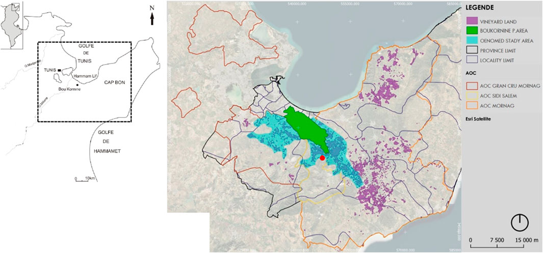
Figure 1. Study area (OENOMED study area (blue) is the result of a zoning based on the opinions of stakeholders).
The park was created because of the important ecological role it plays in reducing the effects of various types of pollution and moderating the local climate (Mechergui et al., 2008). The cedar of Berberice (Tetraclinis cuticulata) makes up the bulk of the vegetation. This park shelters very rare species of plants endemic to Tunisia, such as the Persian cyclamen, orchids and wild tulips. As for the fauna, it presents a wide range of species of mammals, birds, reptiles and insects (Environment and quality of life general division, 2006). The study area is shown in Figure 1. It is located in the north-east of Tunisia, in the provinces of Ben Arous and Nabeul. It has a similar natural and agricultural background, namely vineyards, olive groves, cereals and forests (Hamrita et al., 2023). The study area covers 228,560 ha and has been inhabited since the Roman occupation, with viticulture (M’Sadak et al., 2022). Here, the advanced technology of viticulture and wine trade has been strongly influenced by the various settlers who have settled in the area and have introduced traditional wine-growing practices. The relief of the study area is made up of plains, hills and mountains (Figure 2). The hydrographic system is developed by oued (seasonal watercourse that is usually dry for most of the year and only flows after significant rainfall and particularly common in arid and semi-arid regions) and the least developed soils and vertisols are the predominant soil cover. The climate is moderately cold in winter and dry in summer, with average annual temperatures above 18.7°C and average annual rainfall between 400 and 440 mm (Figure 3).
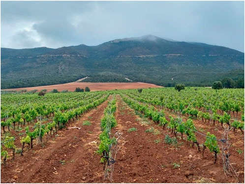
Figure 2. Vineyard Landscape of the protected area of Boukornine. Domaine Neferis (Location in red on Figure 1).
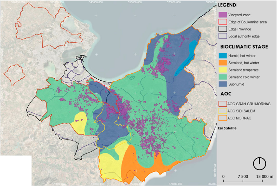
Figure 3. Bioclimatic stage of the study area.
2.2 Historical maps acquisition and recent data
To evaluate the evolution of the land use classes and in particular the change of the vineyard land use in the Boukornine protected area, a comparative analysis was developed based on different maps and using QGIS, starting from historical maps up to recent maps covering the last 2 decades (Table 1).
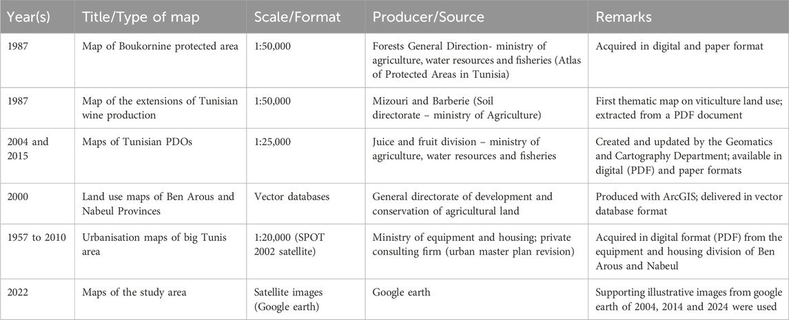
Table 1. Historical maps acquisition and recent data analysis.
2.3 GIS processing
To trace the processes of transformation and evolution of land use and vineyard landscape over the years in the study area, the cartographic documentation was analysed. As a first step, the paper maps were scanned as raster files in TIFF format. The raster data sets were then imported into QGIS for georeferencing. The Control Points Method (technique used in cartography and GIS to align historical or non-georeferenced maps with actual spatial data) was used to associate the historical maps with a common georeferencing system based on the georeferenced maps. The number of CP (Control Points) used was sufficient to achieve a satisfactory level of transformation accuracy. The manual vectorisation method—consisting of raster to vector conversion through manual contour tracing in QGIS or manual polygon creation—was chosen because it does not require proprietary software and, when performed carefully, provides high precision in interpreting map features, particularly for detailed land cover elements such as vineyard parcels (Cervelli and Pindozzi, 2022). The following maps were used for this study, starting from historical maps to the most recent ones: PDO maps, land use maps, in particular vineyard coverage and the Boukornine National Park map. The reclassification of diverse map categories into a common framework was guided by a thematic generalisation process, consolidated into eight consistent land use classes. The following classes were taken into account: Boukornine protected area, PDO, agricultural land, vineyards land, wine cellars, urban land, forest and natural land and water. We focused on the Boukornine protected area and vineyards in order not to lose information on the vineyard landscape. All spatial data were digitized to match the dominant working resolution of 1:260,000, which offers the most balanced level of detail and consistency between datasets. The area to be mapped concerns the three PDOs, Gran cru Mornag, Sidi Salem and Mornag with a total approximate area of 20,000 ha. The spatial analysis focused on the following variables such us the location of vineyards in relation to topographical conditions, urban infrastructure, Boukornine protected area and others natural areas; plot density; and the morphology of farms (size, shape, and orientation).
The thematic generalization of maps was processed according to the classification reported in Table 2.
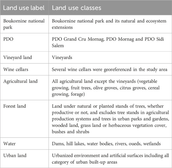
Table 2. Classification of land use.
2.4 Survey and participatory process
As part of the OENOMED project, the survey conducted in the Boukornine Protected Area aims to promote the sustainable development of the MSMC winegrowing sectors within the Grand Cru, Mornag and Sidi Salem PDO. This approach aims to improve agricultural practices by integrating green innovations while taking territorial specifics into account. Developed through a collaborative process involving Tunisian partner institutions (General Direction of Agriculture production and High Agronomic Institute of Chott Mariem), the survey initially used a directive questionnaire, which was then adapted to a semi-directive approach to better understand the complexity of stakeholders’ perceptions, local decision-making processes (Blanchet et al., 2007) and the landscape vineyard change factors like climate change, agricultural development policies, diseases, urban sprawl, by combining literature review and data collection. This methodological flexibility enables a better understanding of the ecological, economic, and social issues specific to winegrowing operations in protected areas (Bérard and Marchenay, 2006). The sample, comprising 23 winegrowers and eight wine producers, reflects the diversity of practices and perceptions within these PDO. The survey protocol contributes to reflections on the relationship between sustainable agriculture, resource conservation, and the development of local entrepreneurial networks within a Mediterranean perspective of integrated territorial development.
The OENOMED project takes an integrated, participatory approach based on the ongoing interaction of public, private and scientific stakeholders with the aim of promoting sustainable practices within the Mediterranean wine industry (Table 3). The Public-Private Animation Groups (PAG) are central to this participatory governance model, facilitating structured dialogue between institutions such as agricultural administrations and local authorities, producers including winegrowers and cooperative wineries, researchers, and civil society representatives. These collaborative spaces facilitate the co-construction of the project’s strategic orientations, particularly with regard to adopting green technological solutions that are adapted to the local context. Additionally, a series of multi-stakeholder workshops were organised to share knowledge, refine methodological tools (including survey questionnaires) and collectively identify obstacles and facilitators to the transition to agroecology. These workshops played an important role in the characterization of the study area (participatory zoning) (Saq et al., 2020) and in the construction of a common language between stakeholders and the emergence of territorialized cooperation networks. The outcomes of the participatory process were synthesised into a structured Local Charter for the Boukornine Protected Area, developed by ISA-Chott Mariem in close collaboration with project partners. The charter outlines a set of mandatory, important, and desirable criteria, categorized into General Farm Characteristics, Agronomic Practices, Environmental Protection Measures, and Cultural and Landscape Heritage Preservation. The list of green and agroecological practices is included in the annex and was finalised by the OENOMED projects steering committee on 31 July 2022. In addition, the participatory process was reinforced by the implementation of regular monitoring and follow-up visits to all winegrowers who formally adhered to the Tunisian Local Charter, aimed at providing concrete support for the implementation of green innovations and ensuring their operational anchoring. These visits, led by the project’s scientific and technical teams, not only enable the progress of practices to be assessed, but also strengthen local dialogue and responsiveness in adapting schemes (Faure et al., 2012). This triptych; facilitation of PAG, workshops and monitoring visit, embodies a methodology for territorial action in favor of sustainable, contextualized and resilient winegrowing development.
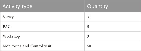
Table 3. Survey, PAG, Workshop and monitoring visit quantity.
2.5 Heritage vectors identification
The participative approach take part also to Heritage Vectors Identification refers to the process of identifying and analyzing the key elements both tangible and intangible that contribute to the cultural, historical, environmental, landscape and symbolic value of a viticulture in the Boukornine protected area combining practice of vine-growing and wine-making. These heritage vectors typically include; tangible components such as traditional vineyard layouts, historic cellar architecture, grape varieties (especially indigenous ones), and winemaking techniques and intangible components like local knowledge systems, oral traditions, rituals associated with wine production, and the socio-cultural identity of wine-producing communities (Pulpon and Ruiz, 2022; Arolli et al., 2023). The qualities of vineyard landscapes such as their aesthetic harmony, scenic coherence, and seasonal rhythms contribute profoundly to their patrimonial value and public appreciation. The recognition of the heritage landscapes of the study area is based on the set of heritage vectors that can identify areas of intensity and density of heritage landscapes. The interest of this exercise is not only analytical but also prospective, as it allows to establish guidelines on what to protect in landscapes (characters, heritage vectors, etc.) and to highlight the aspects that should fall under protection and planning (Hamrita et al., 2023).
3 Results
3.1 Land use changes
Vineyards were a dominant element in all three PDO areas in the 1980s. However, the highest proportion of vineyards in the Mornag PDO was found in the region of Cap Bon and Grombalia. The analysis shows that these two regions were dominated by large block vineyards, while the Ben Arous region had small block vineyards on the Mornag plain. By 1936, however, the proportion of Tunisian vineyards had fallen from 56,000 ha to 32,500 ha as a result of the Daktulosphaira vitifoliae insect attack, and mosaic cropping (vineyards, olive groves and cereals) was the dominant land use in most of the study area. By 1962, the area under vines had increased from 32,500 ha to 45,000 ha. In 1985, the area under vines in the study area reached 25,000 ha because of urban sprawl (Figure 4). It can be noted that since the 2000s the study area has undergone significant changes both in terms of landscape structure and dominant features. Vineyards have been abandoned in the Tunis, Manouba and Ben Arous regions due to the high urbanisation rate 92% (Figure 5). Meanwhile, arboriculture and cereal growing are gaining ground in the Gran Cru Mornag PDO area, as illustrated by the UCP Sidi Massoued farm (Figure 6; Table 4).
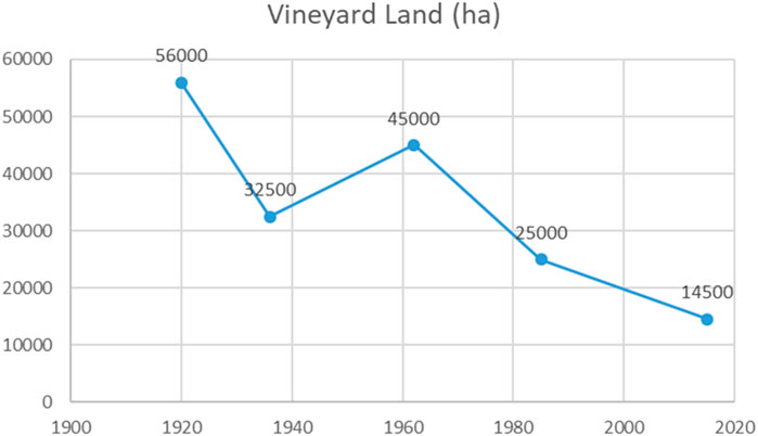
Figure 4. Evolution of the vineyard land in the study area (a,b).
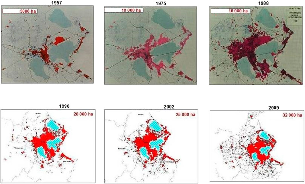
Figure 5. Urban development in the city of greater Tunis. Source: Greater Tunis Urban Agency, 2012.
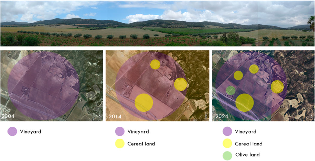
Figure 6. Land use transformation in the UCP SIDI MASSOUD between 2004 and 2024.
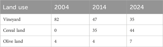
Table 4. Land use (ha) in the UCP SIDI MASSOUD between 2004 and 2024.
In direct contrast, in Grombalia, with a total area of 6 515 ha, vineyards have become dominant and the influence of the driving forces, mainly urban sprawl, is less significant than in the Gran Cru Mornag PDO. Traditional wineries have disappeared from most of the study area, where small (≤10 ha) and medium (10–50 ha) wineries are mainly grouped in cooperatives. However, large wineries (≥50 ha) remain in all PDO within the SMVDA (Agriculture Valorisation and Development Company). Thanks to the restoration and modernisation of the vineyards, the modern plots (marked and irrigated) represent 78% of the total surface of the OENOMED project area (it covers an area of 20,000 ha, of which the vineyards within the perimeter cover approximately 6 200 ha) (Figure 1), while the traditional plots (goblet and dry mode (traditional method of pruning vines, which involves shaping the vine into a small bush without using a trellis. This allows for good aeration and maximum exposure of the bunches to the sun) represent about 22%. However, the establishment of new modern vineyards has led to significant negative environmental and landscape impacts. In addition, the less than optimal natural conditions for viticulture are the reason for the decline and abandonment of traditional vineyards and the development of urbanisation. The greatest urban expansion is in the PDO Gran Cru Mornag under the influence of the Tunis metropolitan area (Figure 7). At the beginning of the 1960s, the city had a spatial amplitude of 10 km, but today the amplitude is 40 km from north to south, which consumes between 400 and 700 ha of land per year (Figure 7). Traditional vineyards are becoming a transition area between urban and rural areas, whose urban planning and master development plan foresees the urbanisation of up to 7% of traditional vineyards in the Mornag region and 5% in Grombalia region, whose total transformation of agricultural land is estimated at 30 ha per year, with a growth rate of 25% between the 1990s and 2014s. Abandonment is often followed by the occupation of the land by spontaneous urbanisation or the replacement of vines by other crops, particularly fruit trees, cereals, olives and grassland. These changes can be observed in areas close to urbanisation, in remote vineyards, in sloping areas, in areas facing the protected area and in areas vulnerable to pig invasion.
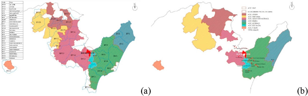
Figure 7. PDO land evolution between (a) 2004 and (b) 2015.
The results of the spatial analysis reveal a marked concentration of vine-growing areas on moderately sloping hillsides and alluvial plains. These areas have particularly fertile soil and water conditions for growing vines. However, a significant spatial regression of traditional vineyards has been observed in the study area, particularly in areas where agricultural plains meet urbanisation fronts resulting from the metropolitan expansion of Tunis. This is reflected in the gradual fragmentation of vineyard plots, their abandonment or conversion for other agricultural or residential use. At the same time, the analysis highlighted the emergence of modernised wine-growing clusters located in areas of high agronomic potential which are supported by public investment policies. These medium-to-large farms feature rationalized plot organisation, trellised management systems, and widespread irrigation, reflecting a spatial reconfiguration of vineyards geared towards technical and economic performance. This spatial interpretation reveals growing tensions between competing forces: intensive agricultural practices in response to demands for modernisation and profitability, environmental constraints related to preserving natural ecosystems and ensuring climatic resilience, and the pressure exerted by diffuse urbanisation reducing cultivated areas.
3.2 Driving forces of change
Vineyards in the study area represent an enormous resource in terms of landscape, natural capital and cultural heritage, in addition to their economic and productive potential (Cervelli and Pindozzi, 2022). At the same time, however, the study area has a highly transformable character due to many factors, in particular the phylloxera epidemic, agricultural policies, urban sprawl and climate change. In the 19th century, there was a major expansion of the cultivated area, thanks to the investment of French settlers. The phylloxera epidemic around 1936 was the main natural cause of the decline of vineyards in Tunisia and Europe (Poláček and Poláček, 2010). This epidemic corresponds to a tiny insect pest, Daktulosphaira vitifoliae, that attacks grapevines. This pest was accidentally introduced to Tunisia in the mid-19th century. The phylloxera insect feeds on the roots and leaves of grapevines, causing damage that eventually kills the plant. The local grapevines in Tunisia, mainly Vitis vinifera varieties, had no resistance to phylloxera. As a result, 42% of Tunisian vineyards suffered damage (Mizouri and Barberie, 1987).
At the same time, political factors strongly influenced the development of viticulture between the mid-19th century and the first half of the 20th century. These included land reforms and changes before and after the French Protectorate. From a financial point of view, the state made great efforts to help wine producers. Loans were granted to winegrowers and wineries, and cooperation was encouraged, as it gave small and medium-sized winegrowers access to the powerful cultural material and sophisticated equipment of wine production. The cooperative movement is developing in Tunisia and tends to preserve and develop the vineyard landscapes of the study area. Tunisia’s independence in 1956 could have meant the end of the wine industry, and viticulture certainly declined. After a period of strong state monopoly in the 1980s and 1990s, when the Central Union of Wine Cooperatives (UCCV) controlled more than 85% of the market, the years 1990–2000 saw a radical change, with a new quality policy based on the injection of capital, the modernisation of production tools and the arrival of international investors through private partnerships, but above all the creation of premium wines that win medals in international competitions. The changes in the case study affected not only the vineyard landscape, but also the whole agricultural landscape due to the food security policy through modernisation, such as mechanisation, crop diversification, irrigation and private agricultural investment.
The development strategies and planning policies of the same period have also modified the vineyard landscape of the study area, mainly urban growth, industrial development and road infrastructures, such as the crossing of the state road (A1) on the border of the Boukornine protected area and the plains of Mornag and Grombalia. The urban growth of the capital Tunis is considered as one of the main driving forces in the shaping of the landscape, with a direct and strong long-term impact on agricultural and forest areas, a fact that is clearly demonstrated by the reduction of almost 1/3 of the surface area of the AOC Grand Cru Mornag (Figure 5). Thus, the wine-growing areas have a particularly fragile and vulnerable status due to their close physical, functional and perceptual proximity, such as their high aesthetic value and beautiful views of the surrounding countryside and the city of Tunis, which is undergoing a major anthropic and environmental transformation. The availability of land reserves, the abandonment of vineyards, the positive migration balance and the urban activities of investment groups have led to the emergence of new peri-urban residential areas at the expense of vineyards, especially in the Mornag plain, where traditional vineyards alternate with houses or solitary vilas.
It has therefore been difficult to maintain and develop viticulture there in the new environmental situation, and this has been exacerbated by climatic factors, such as, increased dryness, rising temperatures, extreme weather events, such as sirocco winds (Figure 8). According the survey, climatic changes and naturel resources degradation appear to be the primary factors affecting viticulture in the study area, around 43% and 39% respectively (Figure 9). Climate change is increasingly threatening the resilience of vineyard landscapes and their ecological conditions, there by compromising the provision of multiple ecosystem services. The survey also found that the Boukornine protected area’s ecosystem services can have a positive impact on viticulture. This is because the park offers a variety of services that benefit agriculture in the surrounding regions, including viticulture. Winegrowers are paying more attention to “provisioning” services, such as water regulation, which helps regulate the local water cycle, improving the availability and quality of water for irrigation. They are also paying more attention to “regulating” services, such as moderating temperatures and increasing humidity by regulating the local microclimate, which the forests in Boukornine can provide. These two services are complemented by the supporting and cultural services provided by Boukornine’s biodiversity and landscape, which can enhance the value of vineyards for agritourism and wine tourism.
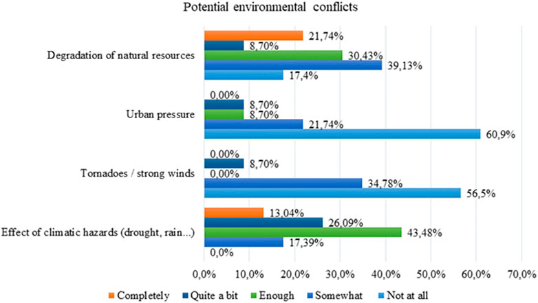
Figure 8. Winegrowers’ perception of the impact of environmental issues on viticulture in the study area.
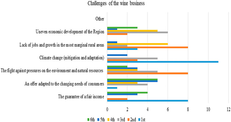
Figure 9. Level of importance of viticulture problems and issues assessed by winegrowers in the study area.
3.3 Vineyard landscapes characteristics of Boukornine protected area
3.3.1 Production system characteristics
In this work, we reviewed the available data on vineyards in the vicinity of the Boukornine National Park in experimental and real ecosystems. The survey showed that 17.39% of the farms located near Boukornine have a total area of over 100 ha, while 60.86% have a vineyard area of less than 10 ha 48% of these vineyards have a production ≤ to 50 t/ha of vine. The effects of forest ecosystems on the stability and productivity of nearby vineyards are considered in order to better assess and predict the effects of climate change. In our case (vineyard around Boukornine), 100% of the vineyards are managed conventionally, of which 65% are under trellis and 43% under cup (Figure 10). However, various changing factors can exert multiple pressures on ecosystem conditions and have direct and indirect effects on viticulture. In particular, the effects of climate change, such as higher temperatures that can reach 44° and altered rainfall patterns, are already posing significant challenges to the integrity and condition of many vineyards in the study area. In addition, the percentage of vineyards irrigated continues to increase each year to reach 78% of the total vineyards around the protected area, in the year 2023, of which 74% of these vineyards use the drip system. The changing climatic conditions are also reflected in more complex interactions between the forest and the surrounding vineyards, as new areas at the edge of the reserve are increasingly planted with resistant grape varieties to diseases and climatic change; Cinsault, Merseguera, Pedro, Carignan, Syrah, Merlot, Vermentino, Viognier, Sauvignon, Chardonny, Grenache, Pinot, Marselan, Sangiovese, Ugni blanc, Cabernet sauvignon, Verdetcho, Muscat, Monica, Clairette and Rezzagi (Figure 11).
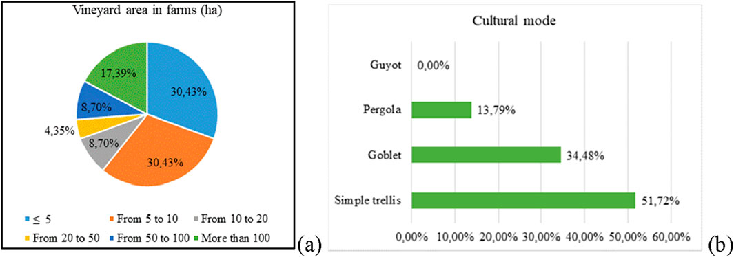
Figure 10. Percentage distribution of different vineyards by (a) farm area in ha and (b) cultural mode.
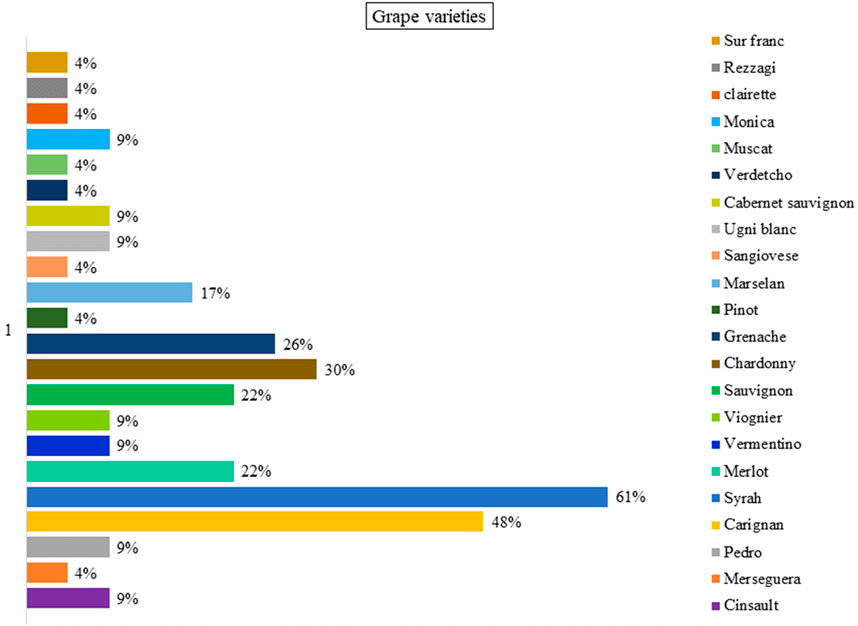
Figure 11. Percentage of winegrowers in the study area cultivating the main grape varieties.
3.3.2 Landscape and heritage vectors
The study area is characterised by an agrarian landscape resembling a mosaic, composed mainly of olive groves, peach orchards, almond orchards, vineyards and cereal fields, which are bordered by windbreaks. Human settlements are organised around colonial-era nuclei and scattered settlements. Like other agrarian landscapes, vineyard landscapes are the result of the ongoing interaction between humans and nature. These evolving cultural landscapes are shaped by economic dynamics, particularly those linked to wine production. The most striking visual feature of these landscapes is the chromatic richness of the vine foliage, which varies according to the season and the variety of grape. The vineyard landscape is based also on natural elements such as soils of contrasting textures and colours, and the land’s topography. These natural elements are complemented by human interventions such as vine-growing methods, the organisation of plots into regular grids, roadways, and iconic buildings such as castles and wine cellars. Alongside this agricultural framework, the study area comprises predominantly natural landscapes consisting mainly of mountain ranges, forests, and bodies of water.
Most of the vineyards in the study area are located on plains, on low and medium slopes, on less developed soils and on vertisols. Vineyards have been established for a long time on the plains of Mornag and Grombalia, on the low and medium slopes of Jbel Boukornine, Jbel Trif, Jbel Bou Argoub and Jbel Ressass. They form a mosaic of landscapes characterized by natural and wooded areas, traditional vineyards, traditional and modern orchards, cereal and grassland, where traditional olive groves predominate. A significant proportion of abandoned vineyards are found in a mosaic of spontaneous constructions, fallow land, arable land and architectural elements in ruins. Comparing all the years studied, four types of changes in the vineyard landscape have been identified in the study area, particularly in the PDO Gran Cru Mornag and PDO Sidi Salem areas: expansion, epidemic disappearance, intensification and modernization and climate change disappearance. Despite these significant changes, numerous heritage vectors have been identified as significant and considered as important arguments for the process of social appropriation, heritage, promotion and qualification of the vineyard landscapes in the study area. The heritage vectors have been processed according to the classification presented in Table 5.
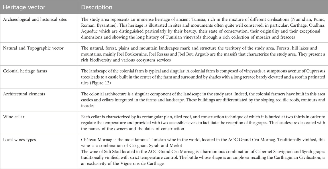
Table 5. Vineyard landscape heritage vectors.
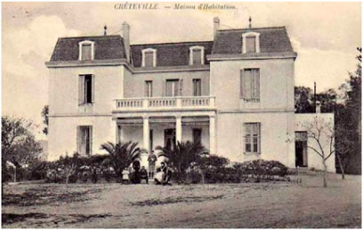
Figure 12. Examples of heritage architectural vectors (Mornag Castle). Source: SMVDA Errissela, 2021.
3.4 Green practices
In the context of the Boukornine protected vineyard area, green practices are gradually emerging as a means of promoting sustainability, enhancing the resilience of the landscape, and celebrating Mediterranean heritage. By adopting the OENOMED Local Charter, several agricultural holdings (AHs) are embracing concrete approaches to agroecology and responsible viticulture, reconciling productivity with the preservation of natural resources and cultural heritage. Rather than being derived from a top-down approach, these virtuous practices were co-developed through Participatory Analysis Groups (GAPs) and stakeholder workshops involving various OENOMED project stakeholders, including farmers, researchers, institutional representatives, and experts. This collaborative approach enabled the identification, discussion, and prioritisation of the most relevant practices for the local context, taking into account the territory’s agroecological, economic, and cultural constraints. The selected criteria were formalised in the Boukornine Protected Area’s Local Charter, one of the OENOMED project’s flagship deliverables.
To ensure the effective and consistent implementation of these practices, all vineyards that signed the Tunisian Local Charter received personalised monitoring and advisory services. This support system helps guide winegrowers in interpreting their commitments, assessing the compliance of on-site practices and providing tailored technical recommendations. It has contributed to establishing a dynamic of continuous improvement towards sustainable viticulture, in line with environmental requirements and societal expectations. Of the encouraged environmental practices, sustainable water management plays a central role. This is reflected in techniques such as rainwater harvesting, underground drip irrigation systems, rational irrigation scheduling and reduced tillage to promote water infiltration. These techniques optimise water resources while limiting erosion and soil degradation. In terms of agronomy, the focus is on organic fertilisation, introducing diverse cover crops such as legumes, crucifers and grasses, and reducing intensive mechanical soil work. These choices aim to improve soil fertility, increase organic matter and enhance functional biodiversity. According to the principles of integrated pest management, the use of phytosanitary products is limited, favouring preventive treatments based on sulphur or Bordeaux mixture.
Furthermore, significant efforts are being made to reduce the farms’ overall environmental footprint: agricultural waste is being recycled, pruning wood is being valorised (through composting and energy production), and the use of herbicides is being strictly limited in favour of mechanical or manual weeding. In terms of social and cultural aspects, the charter emphasises the continuous training of personnel in agroecological practices with the aim of training 50% of staff, as well as promoting native grape varieties and preserving built viticultural heritage. The development of wine tourism also helps to raise public awareness and promote local expertise. In summary, these green practices, resulting from a participatory and contextualised process, strengthen the role of vineyard landscapes as living heritage spaces by combining ecological transition, the local economy and territorial cohesion. These practices are embedded in a collective transition dynamic, supported by diagnostic, monitoring and voluntary commitment tools, as proposed within the framework of the OENOMED project.
4 Discussion
4.1 Methodology limits
This study’s methodology is distinguished by its multidimensional nature, combining cartographic analysis via QGIS and a participatory approach involving local stake-holders. Coupling objective and subjective data in this way is a methodological strength, as it enables measured spatial dynamics to be cross-referenced with local perceptions and the actual practices of winegrowers. However, certain methodological limitations should be acknowledged. Firstly, the quality and resolution of the historical maps used can lead to uncertainty, particularly in areas of high spatial heterogeneity. Secondly, while the number of stakeholders interviewed is substantial, it will be augmented for generalising certain results to the regional scale. Furthermore, the temporal dimension of perceptions gathered via interviews, which are anchored in the present, may not always accurately reflect future developments.
4.2 Vineyards evolution trends
In the case of our study area, many evolutionary trends can be identified that have an important influence on viticulture, land use and landscape. The first, the evolutionary trend towards sustainable viticulture, the main objective of the OENOMED project, will be examined in more detail in the last part of the discussion. The second trend focuses on the conservation and restoration of vineyard landscapes. On the one hand, conservation concerns traditional vineyards and organic farming practices. On the other hand, restoration concerns vineyards affected by the various factors of degradation and also extensions under the label of green practices, carried out in collaboration with vineyard stakeholders in the study area and in the framework of the project. The third evolutionary trend concerns the development of tourism. During the last decades, several alternative or ecological tourism initiatives have appeared in the study area, such as ecological farms, guest houses, etc (UICN, 2016). The aim of these initiatives is to promote the terroir products, the environment and the landscape, in particular the vineyard landscape, its natural elements such as the Boukornine protected area, its heritage, its quality wines and its green cultivation practices. The second last trend is the heritage process. This is the enhancement of significant and/or ordinary heritage landscapes through the participatory inventory of heritage landscapes as a means of identifying, characterising and evaluating heritage landscapes and as a driving force for organic wine production, which can be subject to geographical and commercial indications, but also the enhancement of the vineyard landscape. The last one is the convergence on ecosystem services (ES) or landscape services (LS) essential for human well-being and the sustainability (Termorshuizen and andOpdam, 2009) of viticulture in Mediterranean protected areas, in particular the Boukornine protected area. However, the interfaces between ES/LS and political decisions on planning and development are rare and few applications of the research results on the services of the Boukornine protected area and its vineyard landscape could be integrated into the management modes and public decisions, such as urban land use policies that have strongly influenced vineyards and agricultural practices.
4.3 Driving for conservation and restoration
As the survey of stakeholders has shown, conservation and restoration are two areas that require specific skills and know-how, and can only be implemented by winegrowers who wish to change their conventional practices. The responses revealed significant concerns about environmental pressures, such as water scarcity, soil degradation and climate variability, which have a direct impact on viticulture practices and the sustainability of the landscape. Growers emphasised the need to adapt new practices to mitigate these risks, demonstrating a growing awareness of, and commitment to, sustainable viticulture methods. These findings are consistent with observed landscape transformations, where conventional practices are being replaced by innovative approaches that priorities redesign and diversification of the viticulture ecosystem to optimise ecosystem services (Johnson, 2025). Integrating local agroecological practices (Bérard and Marchenay, 2006) from winegrowers provides valuable insights that reinforce the importance of participatory-action-research in promoting sustainable vineyard management within protected areas (Masson et al., 2021). This community-driven approach is essential for achieving a balance between ecological preservation and agricultural productivity, thereby supporting the long-term viability of the region’s viticulture heritage (Andrade-Suárez and Caamaño-Franco, 2020).
Vineyard landscapes contribute significantly to the economy, identity, culture and biodiversity of many regions of the world (Wang et al., 2021). Analysing the relationships between ecosystem conditions, the wine sector and climate change in vineyards surrounding protected areas is an area for future research. Studies of the effects of climate change on conditions and services important for food production, such as yield, plant growth and soil fertility, are needed to highlight the importance of the multiple ecosystem services provided by vineyards and surrounding forests and natural areas (Winkler et al., 2017). It is noted that research in viticulture has mainly addressed the provision and regulation of ecosystem services, considering vineyards as agricultural landscapes. In fact, this study has examined in a more systemic way all the ecosystem services provided by the ecosystems (protected area-vineyards), without forgetting the socio-cultural services such as identity, aesthetics and tourism. In fact, the co-creation of knowledge from different disciplines is one of the main elements that can support the development of transformative change pathways towards sustainable food and agricultural systems (FAO, 2019). Analysing the interaction between the Boukornine protected area and the surrounding vineyards is focus leans more towards an ecological-landscape approach that will provide opportunities for sustainable agroecosystem management that cannot be achieved by adopting monodisciplinary methods.
Adopting an ecosystem services approach to the study of agroecosystems promotes research that unravels the relationships between the different components of a socio-ecological system, i.e. integrative research (Falardeau and Bennett, 2019). The results of such integrative research will increase knowledge of the components of these systems and their relationships, thus providing the insights and recommendations needed to help decision-makers develop strategies to improve the provision of ecosystem services (Falardeau and Bennett, 2019; Maes et al., 2018). This is particularly important in the context of Boukornine protected area vineyard management under emerging climate scenarios. Policymakers seeking to ensure the resilience of vineyards to climate change need timely and detailed knowledge of the relationships between climate change, ecosystems and ecosystem services of Boukornine protected area. This would identify linkages between components where more research is needed and fill important research gaps in theory and practice.
4.4 Promotion of sustainable viticulture
The promotion of sustainable viticulture is increasingly recognized as essential for the resilience of vineyard landscapes, particularly in regions such as Tunisia where historical and environmental pressures threaten traditional practices. This section examines strategies for promoting sustainable viticulture that balances economic viability with environmental integrity and social responsibility. Transitioning to organic or ecological viticulture can significantly improve soil health, biodiversity and ecosystem services. These practices priorities the use of natural inputs, reduce chemical dependency and promote the ecological balance of vineyards. By using organic methods, growers not only improve the quality of their grapes, but also contribute to the restoration of surrounding ecosystems. This is particularly important in areas such as the Boukornine nature reserve, where integrating vineyards with natural habitats can mitigate urban encroachment and promote biodiversity. Agro-ecology provides a holistic framework for vineyard management, emphasising the interdependence between agricultural practices and ecological systems. Techniques such as crop rotation, intercropping and the use of cover crops can improve soil fertility and reduce erosion while providing habitat for beneficial organisms.
Involving local communities in agro-ecological practices not only enhances local knowledge and culture, but also strengthens the social fabric around viticulture. With the increasing challenges of climate change, effective water management is critical to sustainable viticulture. Implementing drip irrigation and rainwater harvesting systems can optimise water use, reduce waste and improve the resilience of vineyards to drought (Romero et al., 2022). In addition, incorporating practices that improve soil moisture retention, such as mulching and maintaining organic matter, will further support sustainable growth. Sustainable viticulture can also be supported through the development of wine tourism. By creating wine routes and promoting local wines, regions can increase their economic resilience while showcasing their unique cultural heritage. This not only benefits wine producers, but also encourages the preservation of traditional practices and landscapes. Tourism initiatives should emphasise sustainability, ensuring that natural and cultural resources are protected and valued. Finally, robust policy frameworks and support systems are essential to promote sustainable viticulture. Governments and organisations should facilitate access to funding, training and resources for vineyards to transition to sustainable practices. Policies should encourage collaboration between different stakeholders, including local communities, agricultural organisations and environmental groups, to create a coherent approach to sustainable land management.
The study on the transformation of vineyard landscapes in the Boukornine protected area is an component of a more general trend in the Mediterranean. Here too, vineyards share similar challenges with regard to climate change, urbanisation, as well as the obligation to put into place sustainable development. Viticulture is one of the most affected sectors of the Mediterranean by climate change: higher temperatures, heat-waves and drought periods are just some examples. These conditions intensify water-stress pressure in vines and impinge on the phenology and grape composition and the sustainability of the winegrowing business. These effects are additionally enhanced by increasing soil temperature and decreasing humidity, affecting vine growth and productivity (Costa et al., 2023).
Faced with these challenges, wineries in the Mediterranean are implementing different adaptation options. They range from heat- and drought-tolerant grape types to vineyard management changes to the use of ancient farming methods. These mitigation measures seek to preserve wine quality and to have vineyards that are adjusted to different future climate conditions (Luis Gonzaga Santesteban, 2020). Furthermore, Eco-system services multi-criteria evaluation in order to plan green infrastructure (as demonstrated in wine growing metropolitan landscape of Bordeaux) underlines that the green infrastructure (forest, naturel area, protected area) in the regional planning, emphasises the importance of incorporating ecological considerations into the management of winegrowing regions. This approach aims to preserve biodiversity, improve ecosystem resilience, and promote sustainable viticulture (Calia et al., 2023).
Participatory governance is also a significant player in moving to sustainable viticulture. As seen in participatory research with winegrowers in the south-west of France (e.g. projects where winegrowers limit pesticide use, and engage different agro-ecological production systems), engaging local stakeholders in the design and implementation of sustainable interventions can be successful (Perez et al., 2023). This study’s results are consistent with findings in other Mediterranean areas, indicating that we need to embrace sustainable viticulture practices, improve the climate-change resilience of vineyard systems, and engage local stakeholders in the governance of vineyard landscapes.
5 Conclusion
This study presents an overall view of the changing vineyard landscapes around Boukornine national park. Which emphasizes the complicated relationship between eco-logical sustainability, agricultural practices and developments, and territorial pressures. The shift from traditional to mechanized and irrigated viticulture mirrors broader Mediterranean phenomena characterized more intense urban sprawl, land pressure, and declining biodiversity. The vineyards surrounding the Boukornine national park face competing pressures on sprawl, climate change, resources degradation, and declining public policies but rely on the ecological services afforded by the national park, including local micro-climates, biodiversity, and pollution regulation. But we pay little attention to these services in our territorial planning. The study reminds us of the potential ecological role Boukornine national park plays in supporting sustainable vineyards, noting the growing shift toward agro-ecological practices that include organic growing, efficient irrigation practices, and the maintenance and conservation of local grape varieties. The work also reflects the growing recognition of landscape heritage and ecotourism as drivers of sustainable development. The land-scape governance model developed through the OENOMED project, through stake-holder workshops and collective planning with regard to urban pressures on national parks, has demonstrated how new approaches to governance can be relevant for collective action for landscape planning and the management of priorities for land uses. Overall, the paper reemphasizes that sustainable viticulture must be grounded in a broader landscape scale vision that incorporates ecological connectivity, cultural identity, and territorial governance.
Data availability statement
The original contributions presented in the study are included in the article/Supplementary Material, further inquiries can be directed to the corresponding author.
Author contributions
AH: Conceptualization, Writing – original draft, Methodology, Investigation. FH: Funding acquisition, Writing – review and editing. KA: Investigation, Writing – review and editing. RK: Writing – review and editing. MR: Funding acquisition, Writing – review and editing. BA: Validation, Supervision, Writing – review and editing.
Funding
The author(s) declare that financial support was received for the research and/or publication of this article. This work was supported and funded by the Deanship of Scientific Research at Imam Mohammad Ibn Saud Islamic University (IMSIU) (grant number IMSIU-DDRSP2502).
Conflict of interest
The authors declare that the research was conducted in the absence of any commercial or financial relationships that could be construed as a potential conflict of interest.
Generative AI statement
The author(s) declare that no Generative AI was used in the creation of this manuscript.
Publisher’s note
All claims expressed in this article are solely those of the authors and do not necessarily represent those of their affiliated organizations, or those of the publisher, the editors and the reviewers. Any product that may be evaluated in this article, or claim that may be made by its manufacturer, is not guaranteed or endorsed by the publisher.
Supplementary material
The Supplementary Material for this article can be found online at: https://www.frontiersin.org/articles/10.3389/fenvs.2025.1614675/full#supplementary-material
References
Agarwal, C., Green, G. M., Grove, J. M., Evans, T. P., and Schweik, C. M. (2002). A review and assessment of land-use change models: dynamics of space, time, and human choice; general technical report. Newton Square, PA, USA: U.S. Department of Agriculture, Forest Service, Northeastern Research Station.
Andrade-Suárez, M., and Caamaño-Franco, I. (2020). The relationship between industrial heritage, wine tourism, and sustainability: a case of local community perspective. Sustainability 12, 7453. doi:10.3390/su12187453
Arolli, P., Wang, W., Pijl, A., Cucchiaro, S., and Straffelin, E. (2023). Heroic viticulture: environmental and socioeconomic challenges of unique heritage landscapes. iScience 26 (7), 107125. doi:10.1016/j.isci.2023.107125
Ben Mansoura, A., and Mechergui, R. (2008). “Effets de la création du Parc National de Boukornine en Tunisie sur la conservation du thuya et l’évolution des pratiques agro-pastorales des usagers forestiers,” in Systèmes agroforestiers comme technique pour la gestion durable du territoire, 387–409.
Bérard, L., and Marchenay, P. (2006). Local products and geographical indications: taking account of local knowledge and biodiversity. Int. Soc. Sci. J. 58, 109–116. doi:10.1111/j.1468-2451.2006.00592.x
Biasi, R., Farina, R., and Brunori, E. (2021). Family farming plays an essential role in preserving soil functionality: a study on active managed and abandoned traditional tree crop-based systems. Sustainability 13, 3967. doi:10.3390/su13073967
Blanchet, A., Gotman, A., and De singly, F. (2007). L’enquête et ses méthodes: l’entretien. Available online at: https://www.researchgate.net/publication/37414775.
Bouagga, A., Chaabane, H., Chtioui, W., Mougou Hamdane, A., and Nasraoui, B. (2018). “Pesticides used in Tunisian vineyards: what’s the risk for the environment and the human health?,” in Recent Advances in Environmental Science from the Euro-Mediterranean and Surrounding Regions. EMCEI 2017. Editors A. Kallel, M. Ksibi, H. Ben Dhia, and N. Khélifi (Cham: Springer). Advances in science, technology and innovation. doi:10.1007/978-3-319-70548-4_139
Calia, G., Serra, V., Ledda, A., and De Montis, A. (2023). Green infrastructure planning based on ecosystem services multicriteria evaluation: the case of the metropolitan wine landscapes of bordeaux. J. Agric. Eng. 54. doi:10.4081/jae.2023.1531
Cervelli, E., and Pindozzi, S. (2022). The historical transformation of peri-urban land use patterns, via landscape GIS-based analysis and landscape metrics, in the vesuvius area. Appl. Sci. 12, 2442. doi:10.3390/app12052442
Costa, J. M., Egipto, R., Aguiar, F. C., Marques, P., Nogales, A., and Madeira, M. (2023). The role of soil temperature in mediterranean vineyards in a climate change context. Front. Plant Sci. 14, 1145137. doi:10.3389/fpls.2023.1145137
ENI CBC Med. (2021). OENOMED | Qualification et Promotion des filières viti-vinicoles des Aires Protégées de la Méditerranée. Available online at: https://www.enicbcmed.eu/fr/projets/oenomed.
Environment and quality of life general division (2006). Les paysages naturels: Opportunité pour le développement de l’écotourisme. Tunis: Le parc National de Boukornine, 31.
European Environment Agency (2020). State of nature in the EU: results from reporting under the nature directives 2013–2018. Available online at: https://www.eea.europa.eu/publications/state-of-nature-in-the-eu-2020.
Falardeau, M., and Bennett, E. M. (2019). Towards integrated knowledge of climate change in arctic marine systems: a systematic literature review of multidisciplinary research. Arct. Sci. 6, 1–23. doi:10.1139/as-2019-0006
FAO (2019). FAO. Available online at: https://www.fao.org/agroecology/knowledge/10-elements/co-creation-knowledge/en/.
Faure, G., Desjeux, Y., and Gasselin, P. (2012). New challenges in agricultural advisory services from a research perspective: a literature review, synthesis and research agenda. J. Agric. Educ. Ext. 18, 461–492. doi:10.1080/1389224X.2012.707063
Hamrita, A., Boussetta, A., Mata Olmo, R., and Rejeb, H. (2023). Paisagens culturais da vinha: identidades, desafios e oportunidades. La patrimonialisation en faveur des paysages viticoles de la plaine de Mornag: un nouvel axe de développement local d’un territoire à des conflits d’usage. Available online at: https://hdl.handle.net/10216/152539.
Heider, K., Rodriguez Lopez, J. M., Bischoff, A., Balbo, A. L., and Scheffran, J. (2023). Toward climate-resilient and biodiverse agriculture in the mediterranean region: experiences and perceptions of farmers engaged in sustainable food production. Agr 13, 513–529. doi:10.1007/s13165-023-00444-3
Johnson, A. C. (2025). Implementation of agroecological practices in viticulture: Identification of factors that motivate or constrain uptake. [Doctoral Thesis]. Charles Sturt University.
Luis Gonzaga Santesteban. (2020). Stratégies pour l’adaptation des vignobles au changement climatique. (Ré)apprendre de la viticulture méditerranéenne. doi:10.20870/IVES-TR.2020.3788
Maes, J., Burkhard, B., and Geneletti, D. (2018). Ecosystem services are inclusive and deliver multiple values. A comment on the concept of nature’s contributions to people. One Ecosyst. 3, e24720. doi:10.3897/oneeco.3.e24720
Masson, J. E., Soustre-Gacougnolle, I., Perrin, M., Schmitt, C., Henaux, M., Jaugey, C., et al. (2021). Transdisciplinary participatory-action-research from questions to actionable knowledge for sustainable viticulture development. Humanit Soc. Sci. Commun. 8, 24. doi:10.1057/s41599-020-00693-7
Mechergui, R., Ben Mansoura, A., Chaar, H., and Daly, H. (2008). Impact de la protection du parc national de Boukornine sur la conservation des ressources sylvo-pastorales. Ann. l’INRGREF 2 (12), 553–580.
Migliorini, P., Gkisakis, V., Gonzalvez, V., Raigón, M. D., and Bàrberi, P. (2018). Agroecology in mediterranean Europe: Genesis, state and perspectives. Sustainability 10, 2724. doi:10.3390/su10082724
Mizouri, M., and Barberie, J. (1987). Note relative à la carte des extensions de la Tunisie viticole. Dir. Sols, Ministère l’Agriculture, Tunisia. Scale 1, 50000.
M’Sadak, Y., Ferjani, H., and Dahmouni, M. (2022). Caractérisation quantitative et qualitative des effluents de cave et possibilités de biovalorisation: revue de l’art. Maghrebian J. Pure Appl. Sci. 8 (1), 10–25.
Oliveira, M. J., Santos, C., Gonçalves, I., Soares, R., Pereira, S., Castro, P., et al. (2024). “Promoting sustainability in mediterranean agriculture: insights from the Portuguese Vine and wine sector,” in IVES Conference Series, OIV 2024.
Perez, M., Hossard, L., Gary, C., Lacapelle, P., Robin, M.-H., and Metay, A. (2023). A participatory approach to involve winegrowers in pesticide use reduction in viticulture in the south-western region of France. Italian J. Agron. 18 (4), 2209. doi:10.4081/ija.2023.2209
Poláček, Š., and Poláček, M. (2010). Vinohradníctvo a vinárstvo – stručná história a súčasnosť; Nitra. Slovenská.
Porte, B., Rochard, J., van Helden, M., Guenser, J., and Fulchin, E. (2020). GIS for planning conservation actions in viticulture landscapes. IOBC-WPRS Bulletin. Available online at: https://iobc-wprs.org/product/gis-for-planning-conservation-actions-in-viticulture-landscapes/.
Pulpon, A. R. R., and Ruiz, M. D. C. (2022). Intangible heritage and territorial identity in the multifunctional agrarian systems of vineyards in Castilla-La Mancha (spain). Land 11 (2), 281. doi:10.3390/land11020281
Raveloaritiana, E., Wurz, A., Osen, K., Soazafy, M. R., Grass, I., Martin, D. A., et al. (2023). Complementary ecosystem services from multiple land uses highlight the importance of tropical mosaic landscapes. Ambio 52 (10), 1558–1574. doi:10.1007/s13280-023-01888-3
Romero, P., Navarro, J. M., and Ordaz, P. B. (2022). Towards a sustainable viticulture: the combination of deficit irrigation strategies and agroecological practices in mediterranean vineyards. A review and update. Agric. Water Manag. 259, 107216. doi:10.1016/j.agwat.2021.107216
Ruiz Pulpón Á, R., and Cañizares Ruiz, M. D. C. (2019). Potential of vineyard landscapes for sustainable tourism. Geosciences 9, 472. doi:10.3390/geosciences9110472
Saqalli, M., Hamrita, A., Maestripieri, N., Boussetta, A., Rejeb, H., Mata Olmo, R., et al. (2020). “not seen, not considered”: mapping local perception of environmental risks in the plain of mornag and jebel ressass (tunisia). Euro-Mediterranean J. Environ. Integration 5, 30–14. doi:10.1007/s41207-020-00166-y
Stefunkova, D., and Hanusin, J. (2019). Viticultural landscapes: localised transformations over the past 150 years through an analysis of three case studies in Slovakia. Morav. Geogr. Rep. 27, 155–168Š.
Termorshuizen, J., and andOpdam, P. (2009). Landscapeservicesasabridgebetween landscape ecology and sustainable development. Landsc. Ecol. 24, 1037–1052. doi:10.1007/s10980-008-9314-8
Wang, J., Guan, Y., Wu, L., Guan, X., Cai, W., Huang, J., et al. (2021). Changing lengths of the four seasons by global warming. Geophys. Res. Lett. 48, e2020GL091753. doi:10.1029/2020gl091753
Winkler, K. J., Viers, J. H., and Nicholas, K. A. (2017). Assessing ecosystem services and multifunctionality for vineyard systems. Front.Environ. Sci. 5. doi:10.3389/fenvs.2017.00015
Winter, S., Bauer, T., Strauss, P., Kratschmer, S., Paredes, D., Popescu, D., et al. (2018). Effects of vegetation management intensity on biodiversity and ecosystem services in vineyards: a meta-analysis. J. Appl. Ecol. 55 (5), 2484–2495. doi:10.1111/1365-2664.13124
Keywords: vineyard landscapes, GIS process, participatory frameworks, land use change, sustainable viticulture, Boukornine protected area
Citation: Hamrita A, Haouala F, Annabi K, Kouki R, Rejili M and Al Mohandes Dridi B (2025) Evolution and transformation of vineyard landscapes and promotion of sustainable viticulture. The case of Boukornine protected area in Tunisia. Front. Environ. Sci. 13:1614675. doi: 10.3389/fenvs.2025.1614675
Received: 19 April 2025; Accepted: 07 July 2025;
Published: 22 July 2025.
Edited by:
Gianluca Pappaccogli, University of Salento, ItalyReviewed by:
Barış Kahveci, Niğde Ömer Halisdemir University, TürkiyeLuis Fernando Gopar-Merino, Universidad Autónoma del Estado de México, Mexico
Copyright © 2025 Hamrita, Haouala, Annabi, Kouki, Rejili and Al Mohandes Dridi. This is an open-access article distributed under the terms of the Creative Commons Attribution License (CC BY). The use, distribution or reproduction in other forums is permitted, provided the original author(s) and the copyright owner(s) are credited and that the original publication in this journal is cited, in accordance with accepted academic practice. No use, distribution or reproduction is permitted which does not comply with these terms.
*Correspondence: Abdelkarim Hamrita, YWJkZWxrYXJpbWhhbXJpdGFAZ21haWwuY29t
†ORCID: Faouzi Haouala, orcid.org/0000-0001-8633-9387; Mokhtar Rejili, orcid.org/0000-0003-1574-4216