 Sergii Sukharev1
 Ruslan Mariychuk
- 1Department of Ecology and Environmental Protection, Educational and Scientific Institute of Chemistry and Ecology, Uzhhorod National University, Uzhhorod, Ukraine
- 2Department of Ecology, Faculty of Humanities and Natural Sciences, University of Presov, Presov, Slovakia
- 3Center Supply Department, Transcarpathian Region Scientific Research Forensic Center of the Ministry of Internal Affairs of Ukraine, Uzhhorod, Ukraine
The territory of the Tisza River Basin has a complex geological and tectonic structure, also pronounced landscape zoning with different types of soil. The assessment of the actual background state of soils was carried out within the national natural parks in 0–20, 20–50, and >50 cm soil profiles in terms of the content of heavy metals (HMs) and the radioactivity of gamma-active radionuclides (RNs). The studied national nature parks are located in different landscape areas (mountains, foothills, and lowlands) with different tectonics, geology, and soil types. Comparison of data on the content of HMs in soils shows that the total concentration of HMs is low (gross content for the 0–20 cm profiles: Zn - 19.8 ÷ 30.1; Cu - 9.6 ÷ 14.1, Pb - 9.4 ÷ 15.8, Cd - 1.10 ÷ 1.76 mg⋅kg−1 and content of acid-soluble forms: Zn – 8.7 ÷ 13.2; Cu – 0.67 ÷ 1.01, Pb – 7.6 ÷ 12.8, Cd – 0.36 ÷ 0.58 mg⋅kg−1) with a characteristic increase from mountainous to lowland landscapes. Based on a comparison of the content of HMs in soil profiles and the migration coefficient, it was established that lead (concentrated in the profile 0–20 cm; the migration coefficient is about 81% for lowland landscapes) is of anthropogenic origin, while other HMs are of natural origin. The results of radiological studies show that the radioactivity of technogenic 137Cs in soils is not high (13.5 ÷ 24.8 Bq⋅kg-1) with a characteristic increase from mountainous to lowland landscapes. The difference in the radioactivity of natural RNs (238U and 232Th series) for soils of different landscape zones is characteristic. For soils of mountainous landscapes, the total radioactivity of natural gamma-active RNs (excluding 40K) is significantly higher (254 ± 27 Bq⋅kg−1) than for foothill (239 ± 52 Bq⋅kg−1) and lowland (106 ± 38 Bq⋅kg−1) soils. This is obviously related to the tectonic activity of the young Carpathian Mountains. At the same time, the ratio of the sums of radioactivity of RNs of the 232Th and 238U series (Σ 232Th/Σ 238U) differs significantly for soils of different landscape zones. In the soils of mountain zones, natural RNs of the 238U series (Σ 232Th/Σ 238U = 0.87 ± 0.19) predominate, while in the foothills (Σ 232Th/Σ 238U = 2.26 ± 0.41) and lowlands (Σ 232Th/Σ 238U = 2.32 ± 1.47), RNs of the 232Th series predominate.
1 Introduction
Soils perform a global function (Blum, 2005; Lal et al., 2021) and play an important role in maintaining ecosystems (Briones, 2014; Drobnik et al., 2018; Rabot et al., 2018; Saco et al., 2021). The state of soil is assessed using various indicators (Schloter et al., 2003; Allen et al., 2011). In addition to degradation, heavy metals (HMs) (Kim et al., 2015; Kumar et al., 2019) and radionuclides (RNs) (Mandujano-García et al., 2016; Kardan et al., 2017) play an important role in soil assessment. The content of HMs and RNs in soils is influenced by both the geochemical characteristics of the territories (Ali et al., 2016; do Carmo Leal et al., 2020) and the anthropogenic pollution (Barbieri et al., 2018; Sarkar et al., 2022). Therefore, soil monitoring (Morvan et al., 2008; Teng et al., 2014) is essential for controlling and mitigating environmental risk.
In the soil monitoring system, a special role is played by background monitoring (Dung et al., 2013; Esmaeili et al., 2014), which is carried out within the nature reserve fund. Systematic soil monitoring through the study of soil profiles (Nenadović et al., 2012; Seo et al., 2019; Ahmad et al., 2019), facilitates the assessment of eco-pollutant distribution, mobility, and origin (de Matos et al., 2001; Pikuła and Stępień, 2021). However, background monitoring studies of this type have not been previously conducted in the Transcarpathian region of Ukraine. Radiological studies (Maslyuk et al., 2016) have only been performed on the humus horizons of soils within the Carpathian National Parks in the Transcarpathian region of Ukraine. Vertical distribution of RN and HM in soil has not been previously assessed.
The territory of the Tisza River Basin (Ukraine) has a complex tectonic and geological structure (Sukharev et al., 2020) with characteristic landscape transitions from mountainous areas to foothill and lowland. The water regime of the Tisa River is determined by the predominant snow and rainy power, with characteristic spring floods and freshets in the summer and autumn (Şerban et al., 2020). The territory of the Upper Tisza Basin primarily consists of flysch areas and rock zones, while the Middle Tisza Basin encompasses the Volcanic Carpathians, and the Lower Tisza covers the Transcarpathian deflection. Within the Tisza River Basin, there are three national nature parks with different geological characteristics and soil types. This study presents the results of background soil monitoring in the Upper Tisza River Basin (Ukraine), focusing on the distribution of selected HMs (Cu, Zn, Pb, Cd) and RNs, including natural series 238U and 232Th, as well as technogenic 137Cs, within soil profiles.
The research methodology involves covering all landscape zones that are characteristic of the Tisza River Basin within Ukraine. This allows data on the current background state of soils to be disseminated to adjacent territories, which is important for sustainable land resource management. Systematic studies of this type using GIS technologies play an important role in the strategy of land management (Valjarević et al., 2025).
The choice of HMs and RNs as criteria for assessing the background state of soils is due to the significant differentiation of the territory of the Tisza River Basin in terms of geology and tectonics (Sukharev et al., 2020), as well as different levels of anthropogenic load in the adjacent territories. The territory of the National Nature Park “Synevyr” tectonically covers two zones: the flysch zone in the zone of rocks and the volcanic Carpathians (Sukharev et al., 2020). Geologically, the territory of the National Nature Park “Synevyr” includes the Paleogene (undivided deposits, diverse-rhythmic flysch, bituminous mudstone, and marls), the Paleogene–Lower Miocene (undivided deposits, flysch), and the Upper Cretaceous–Paleogene (diverse-rhythmic flysch and bituminous mudstones). Tectonically, the territory of the National Nature Park “Uzhansky” covers part of the flush zone, the Transcarpathian deflection, and the volcanic Carpathians. The geology of the area is quite complex, including the Paleogene (undivided deposits, diverse-rhythmic flysch, bituminous mudstone, and marls), the Cretaceous (undivided deposits, flysch, marls, and variegated formations), the Lower Cretaceous (mostly dark-colored flint and three-component flysch), and the Upper Cretaceous–Paleogene (diverse-rhythmic flysch and bituminous mudstones). The territory of the National Nature Park “Zacharovanyi Krai” covers the Transcarpathian deflection and, to a lesser extent, the volcanic Carpathians and flush zone. Geologically, the territory is dominated by Neogene formations (undivided deposits, volcanites of various compositions–basalts, andesite, dacites, liparites, and their tuffs), Paleogene formations (undivided deposits, diverse-rhythmic flysch, bituminous mudstone, and marls), and Upper Cretaceous-Paleogene formations (diverse-rhythmic flysch and bituminous mudstones).
In mountain landscapes (National Nature Park “Synevyr”), mountain-forest loam soils (gray and light brown) and mountain-meadow soils (gray) prevail; in foothill landscapes (National Nature Park “Uzhansky”), mountain-forest loam soils (light brown and dark brown); and in lowland landscapes (National Nature Park “Zacharovanyi Krai”), brown mountain-forest soils (medium-deep and deep podzolized heavy loams, as well as shallow medium loams).
2 Materials and methods
2.1 Characteristics of the study areas
The Tisza River originates in the Transcarpathian region of Ukraine and flows downstream along the Ukrainian-Hungarian border, tracing the boundary with Romania. The Tisza River Basin, the largest sub-basin within the Danube River Basin, spans an area of 157,186 km2 and extends across Ukraine, Romania, Hungary, Slovakia, and Serbia. The territory of the Upper Tisza River Basin consists mainly of nature reserves (Figure 1). The studied area lacks industrial facilities, and tourist and recreational activities take place there.
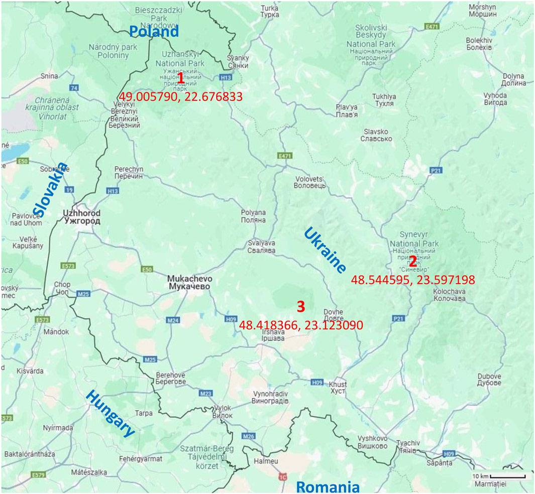
Figure 1. Map of the Transcarpathian region of Ukraine with locations of the National Nature Parks: 1 - “Synevyr”, 2 - “Uzhansky”, and 3 - “Zacharovanyi Krai” (Google, 2025).
National Nature Park “Uzhansky” (49.005790, 22.676833), the Ukrainian part of the Biosphere Reserve “Eastern Carpathians”, mainly foothill landscapes, elevation 850–230 m above sea level, high forest cover of the territory with beech primeval forests.
National Nature Park “Synevyr” (48.544595, 23.597198) is characterized by predominantly mountainous landscapes, with elevations ranging from 440 to 1,720 m above sea level. The area is heavily forested, featuring extensive spruce-beech primeval forests (Ustymenko et al., 2022).
National Nature Park “Zacharovanyi Krai” (48.418366, 23.123090) is mainly characterized by lowland landscapes, with elevation differences ranging from 130 to 630 m above sea level. The area has extensive forest cover, primarily consisting of primeval beech forests (Shyshkanynets et al., 2024).
2.2 Soil sampling, sample preparation
Investigated soil profiles: humus horizon −0 ÷ 20 cm, eluvial horizon −20 ÷ 50 cm, carbonate geochemical barrier >50 cm. Soil samples were collected using cores, following the procedure outlined by Tan (2005). Soil samples were cleaned of organic residues and stones, averaged, dried at room temperature to “air-dry” and sieved through a sieve (hole diameter 1.0 mm). Humidity was controlled gravimetrically.
In each National Nature Park, ten soil sampling sites were selected considering the landscape features and geological characteristics of the territories. The sampling strategy assumed that all soil types of the territory (taking into account the area ratio), all landscape features (mountain peaks, slopes, foothills, etc.), and forest cover with a characteristic plant type, as well as geological anomalies, if they occur, were covered.
Radiological studies of soil state were carried out directly without additional sample preparation. Determination of HMs content included: 1. Determination of total content: samples were digested using the aqua regia method according to the procedures (Hseu et al., 2002; Soodan et al., 2014), resulting in an acid mineralizate solution; 2. Determination of acid-soluble forms: an acid extract was obtained from the soil using nitric acid (HNO3, 1 mol⋅L−1). All reagents utilized in the study were of analytical-grade purity and obtained from Sigma-Aldrich (St. Louis, MO, United States) or Merck (Darmstadt, Germany). Double-distilled water (DDW) was utilized in all experiments.
2.3 Apparatus, procedures
An atomic absorption spectrometer, Shimadzu AA-7000 (Shimadzu, Japan), equipped with a graphite tube atomizer, was used for the determination of the HMs content in soil samples. The soil mineral solution and the acid extract were investigated, respectively. Palladium nitrate (Merck, CAS No.: 10102-05-3, Palladium Matrix Modifier for graphite furnace-AAS) served as a chemical modifier. The measurement parameters were as follows: sample volume was 20 μL; wavelengths for Cd were 228.8 nm (slit 0.7 nm), Pb were 283.3 nm (slit 0.7 nm), Zn were 213.9 nm (slit 1.0 nm), and Cu were 324.8 nm (slit 0.5 nm). The Zeeman effect for the background correction was applied. Pure argon (99.99%, flow is 100 mL⋅min−1) was used as a shielding gas.
The furnace program for atomic-absorption measurements consists of several stages, each with specific temperature settings, heating speeds, durations, and argon flow conditions. We performed the first drying stage at 80°C with a high heating speed for 20 s, including argon flow. Then, we carried out the second drying phase at 160°C with a slow heating speed, also for 20 s, while maintaining argon flow. Next, pyrolysis is conducted at 950°C with a high heating speed for 10 s, again with argon flow included. Atomization is performed at a variable temperature depending on the element being analyzed. It occurs at a high heating speed over 5 s, but with argon flow excluded during this process. Optimal atomization temperatures are set at 2,300°C for cadmium (Cd), lead (Pb), and zinc (Zn), while copper (Cu) requires a slightly higher temperature of 2,400°C. Finally, the cleaning stage takes place at 2,800°C with a high heating speed, lasting for 3 s, with argon flow included to ensure the removal of residual materials. This structured sequence ensures precise atomic-absorption measurements while maintaining control over sample preparation and analysis conditions. Each soil sample was analyzed six times in parallel, and the results were statistically processed.
A multi-element standard solution (Merck, Multielement Standard Solution 6 for ICP, TraceCERT®, UNSPSC Code: 41116107) was used to prepare the standard calibration solutions.
Measurements of the absolute activity of RNs were carried out under low-background conditions (combined protection) on a gamma-spectroscopy complex “SBS-40” with a cooled 100 cm3 and 175 cm3 HPGe coaxial semiconductor Ge(Li)-detector. The measurement was carried out according to the procedure outlined by Symkanich et al. (2023) with a measurement time of 5,000 s. As a reference source for calibration (energy and efficiency calibration), KOUHC (152Eu and combined samples 40K–137Сs) was used (bulk source of cuvette size). Each soil sample underwent six repeated analyses, followed by statistical processing of the results.
Soil acidity was determined by the procedure (ISO, 2005). The actual acidity of the soils determined potentiometrically by measuring the pH of an aqueous soil extract (soil: water ratio = 1:5). Measurements were performed using an HI-2211 pH/ORP meter (HANNA Instruments, USA). Determination of organic carbon in soils was carried out according to international standard (ISO, 1998) and the determination of the potential cation exchange capacity of soils was carried out according to standard (ISO, 2023). The organic carbon content was determined by a spectrometric method by oxidizing an accurate amount of soil in a sulfochromic medium and measuring the absorbance of the solution after the oxidation procedure (at a wavelength of 585 nm, spectrophotometer Shimadzu UV-2600, Shimadzu Co., Japan). The potential cation exchange capacity of soils was determined chemically using ammonium acetate solution at pH 7.
Mapping of territories was carried out using the “ArcGIS 10.2.1” program (Esri, 2019).
Mapping was carried out using the Kriging method (Kruglov model) as a prediction based on the coordinates of the soil sampling sites. The selection of adjacent sites was standard.
Cluster analysis was carried out applying Statistica 12.0 software using the hierarchical clustering method. The variables were standardized before clustering.
3 Results
3.1 Results of determining individual chemical indicators of soil condition
The properties of the soil of these territories play an important role. The soils of the National Nature Park “Synevyr” (mountain landscapes) are quite acidic (pH water extraction 4.0 ± 0.2), have a low organic carbon content (0.73% ± 0.11%), and have a low cation exchange capacity (29.9 ± 3.1 meq⋅100 g−1). The soils of the National Nature Park “Uzhansky” (foothill landscapes) are less acidic (pH water extraction 4.6 ± 0.5), have a higher organic carbon content (1.41% ± 0.49%), and have a higher cation exchange capacity (34.7 ± 3.2 meq⋅100 g−1). The soils of the National Nature Park “Zacharovanyi Krai” (lowland landscapes) are more acidic (pH water extraction 4.3 ± 0.4) than those of the National Nature Park “Uzhansky”, have a lower organic carbon content (0.89% ± 0.31%), but a higher cation exchange capacity (37.4 ± 3.9 meq⋅100 g−1).
3.2 Radiological research results
Table 1 presents a summary of the radiological studies conducted on the soils of National Nature Parks in the Tisa River Basin. The data in Table 1 show a significant difference in radioactivity of RN both for soils of different landscape zones and across soil profiles. A comparative analysis of the data in Table 1 shows a number of patterns. Firstly, the radioactivity of natural 40K varies significantly within the boundaries of each national natural park, which is obviously associated with different types of soils within the territory. Therefore, data on the radioactivity of natural 40K are not particularly informative. In general, the radioactivity of 40K in soils is highest for foothill landscape zones. The radioactivity of 40K varies slightly across soil profiles. Secondly, the radioactivity of technogenic 137Cs is the highest for the humus soil profile (0–20 cm), especially for lowland landscape zones. Meanwhile, the distribution of technogenic 137Cs within the humus soil profile varies considerably across the national nature parks, largely influenced by the geological and morphological characteristics of the respective territories. As an example, Figure 2 shows the distribution of 137Cs in humus horizons within the National Nature Park “Uzhansky” (foothill landscapes). The data in Figure 2 show that technogenic 137Cs is concentrated in the soils of the lowland part of the National Natural Park “Uzhansky”. Third, the total radioactivity of natural radionuclides (238U and 232Th series), excluding 40K, differs significantly for soils of different landscape zones: mountainous (254 ± 27 Bq⋅kg−1), foothill (239 ± 52 Bq⋅kg−1), and lowland (106 ± 38 Bq⋅kg−1). This is obviously related to the tectonic activity of the young Carpathian Mountains. The distribution of natural radionuclides (total radioactivity) in the humus soil horizon within individual National Natural Parks depends on the geology and tectonics of their territories. For example, Figure 3 shows the distribution of the total radioactivity of natural RNs within the National Natural Park “Synevyr”. The maximum radioactivity of RNs is concentrated within the mountain ranges (gray mountain-meadow soils). These patterns in the distribution of natural gamma-active RNs seem to be associated with the tectonic and geological structures of the studied territories (Sukharev et al., 2020). This geological structure causes the release of 222Rn (238U series) from mountain faults, which ensures the dominance of 238Uranium series RNs in mountain landscapes. There is no significant difference in the distribution of natural RNs in soil profiles, as can be seen from the data in Figure 4, which shows such a distribution for soil profiles of the National Nature Park “Zacharovanyi Krai”. The nature of the localization and vertical distribution of natural RNs in soil profiles is associated with lithological variations and soil type. As can be seen from Figure 4, the localization of natural radionuclides is observed in the western part of the National Nature Park “Zacharovanyi Krai”, where foothill landscapes and brown mountain-forest medium-deep podzolized heavy loam soils prevail. The localization of natural RNs within the territory is distinct, since the difference in RNs radioactivity for different areas differs by 2–3 times. With the vertical transition from the carbonate geochemical barrier (>50 cm) to the eluvial horizon (20–50 cm) and the humus horizon (0–20 cm), the area of localization of natural RNs increases somewhat. This natural process is associated with different properties of soil horizons. At the same time, the averaged data on RNs’ radioactivity (Table 1) do not show this. Fourth, in the soils of mountain zones, particularly within the humus soil profile, natural RNs from the 238U series (Σ 232Th/Σ 238U = 0.87 ± 0.19) are predominant. In contrast, RNs from the 232Th series prevail in the foothills (Σ 232Th/Σ 238U = 2.26 ± 0.41) and lowland areas (Σ 232Th/Σ 238U = 2.32 ± 1.47).
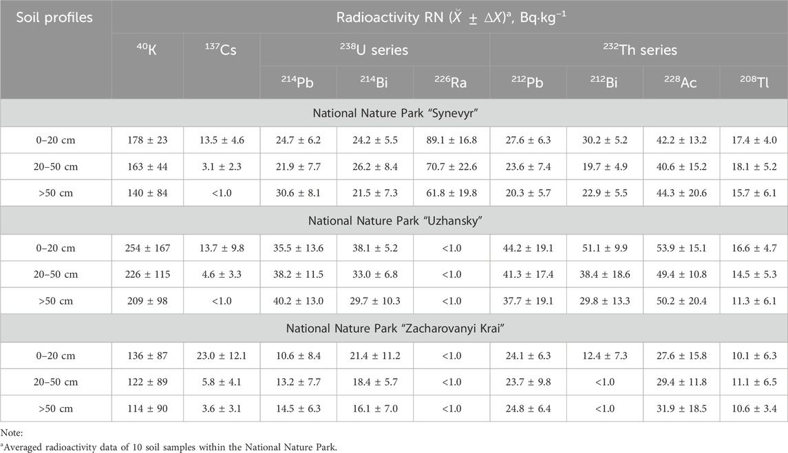
Table 1. The summarized data of radiological studies of soils.
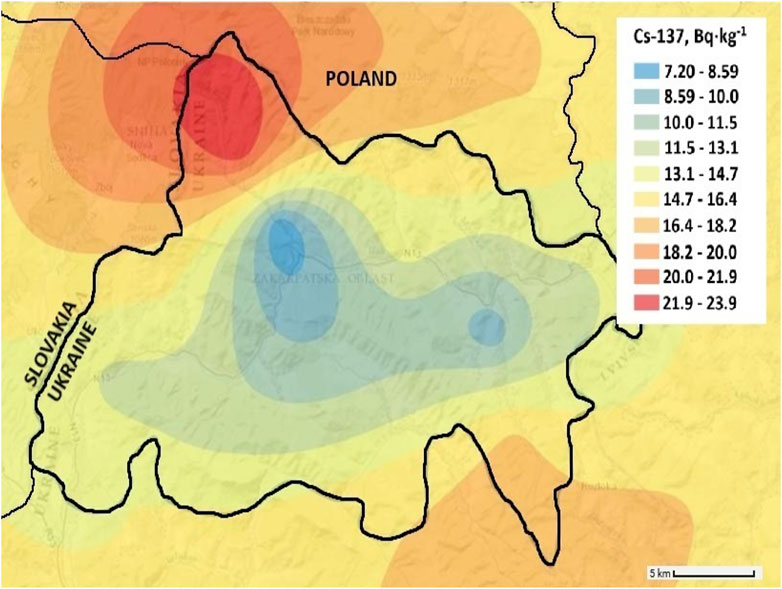
Figure 2. Map of 137Cs distribution in the humus soil profile of the National Nature Park “Uzhansky”.
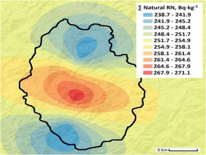
Figure 3. Map of total radioactivity of the natural radionuclides (excluding 40K) distribution in the humus soil profile of the National Nature Park “Synevyr”.
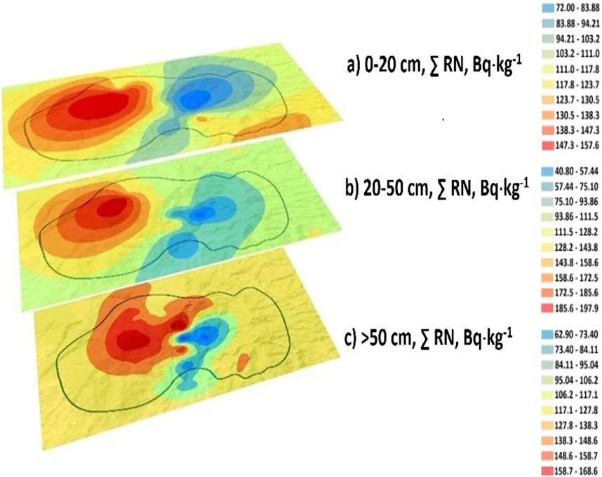
Figure 4. Distribution of total radioactivity of natural radionuclides (excluding 40K) in soil profiles of the National Nature Park “Zacharovanyi Krai”.
The most complex geological conditions among the studied nature reserves are characteristic of the National Nature Park “Uzhansky” (Sukharev et al., 2020). Therefore, for this territory, we carried out a cluster analysis of the distribution of the total of RNs by the location of sampling points (Figure 5a) and individual RNs among themselves (Figure 5b). The results of cluster analysis show a pronounced correlation of the distribution of radionuclides within the territory of the National Nature Park “Uzhansky” and among themselves.
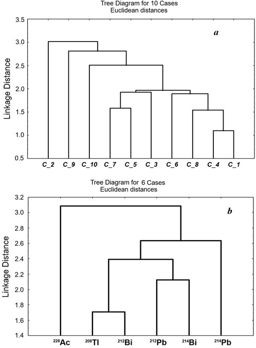
Figure 5. Results of the cluster analysis of total RN radioactivity distribution within the territory of the National Nature Park “Uzhansky” for ten soil samples C_1, C_2, … C_10 (a) and its correlation among individual radionuclides (b).
3.3 Results of heavy metal content determination
The summarized data of determination of HMs in soils of National Nature Parks (Tisa River Basin) are presented in Table 2. The overall distribution patterns of HM content in soils differ fundamentally from those of the radioactivity of RNs. The general trends of HM content in soils of protected areas (for different landscape zones) have been established. Firstly, the content of HMs in soils increases when moving from mountainous to foothill and lowland areas. To illustrate this pattern, Figure 6 displays the HM content in the humus soil horizon (0–20 cm) for all examined National Nature Parks. Secondly, the value of the lead (81%) migration coefficient (the ratio of the content of acid-soluble forms to the total content) for the humus soil profile of the National Nature Park “Zacharovanyi Krai” indicates that lead is obviously of anthropogenic origin. This is obviously due to atmospheric deposition. The areas surrounding the National Nature Park “Zacharovanyi Krai” consist of agricultural land with a well-developed transport infrastructure. Leaded gasoline was used in Ukraine for a long time, which is the reason for the increased lead content in the soil. There are no other anthropogenic sources of pollution. Third, the distribution of the total HMs content in the soils of individual National Nature Parks contrasts with the distribution of the total radioactivity of RNs. Figure 7 shows the distribution of the sum of HMs in the humus soil horizon of the National Nature Park “Synevyr” (mountain-forest light brown loam soils). Comparison of the data in Figures 3, 7 shows the opposite relationship for the same area. HMs accumulate primarily on the slopes and foothills of the mountains. Soil profiles show similar patterns. For example, Figure 8 shows the distribution of the total content of heavy metals in soil profiles of the National Nature Park “Zacharovanyi Krai”. As can be seen from Figure 8, HMs are localized mainly in the eastern part of the National Nature Park. The distribution is significantly influenced by lead content of anthropogenic origin, as the eastern part of the territory is much closer to agricultural areas with a well-developed transport system. With a vertical transition, the area of localization of HMs practically does not change. The pattern of distribution of HMs within the territory of the National Nature Park “Zacharovanyi Krai” is not sufficiently pronounced, unlike the RNs, since the total amount of HMs for different areas differs by less than 10%. Despite this, comparison of the data in Figures 4, 8 clearly highlights the inverse relationship between the distribution of HMs and RNs in soils.
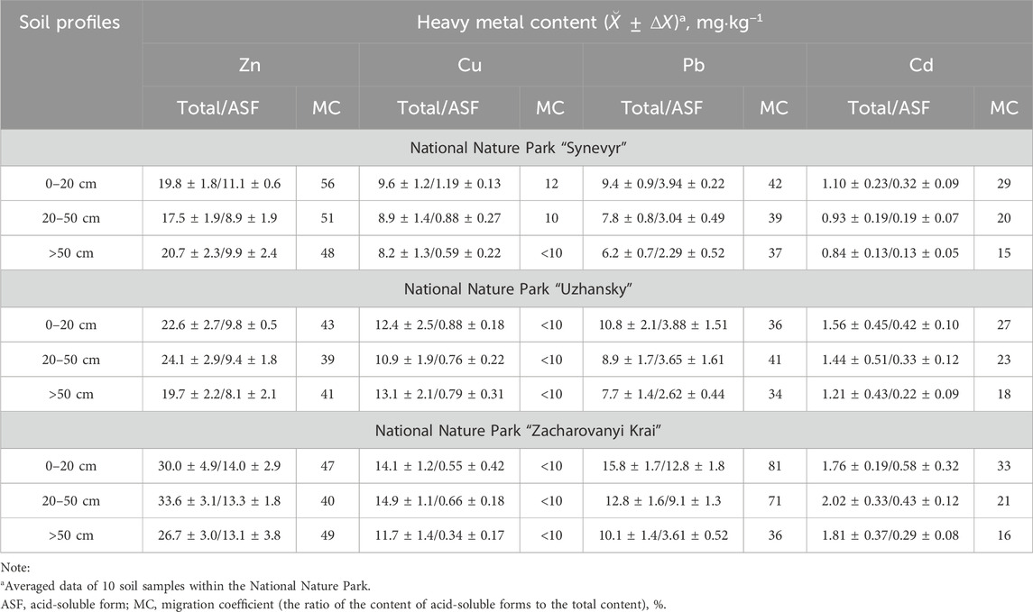
Table 2. The summarized data of determination of heavy metals in soils.
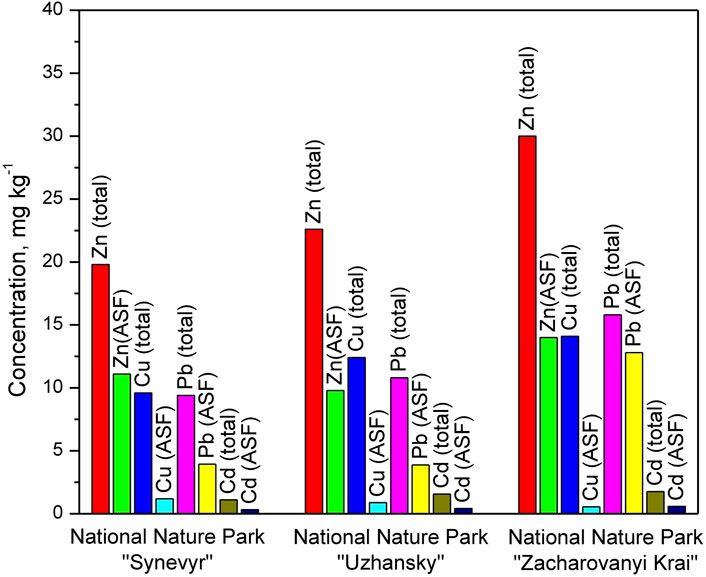
Figure 6. The content of heavy metals in the humus soil horizon (0–20 cm) across the examined National Nature Parks.
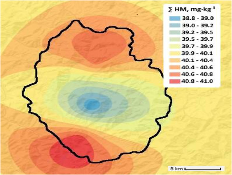
Figure 7. Distribution of the total heavy metals content in the humus soil horizons of the National Nature Park “Synevyr”.
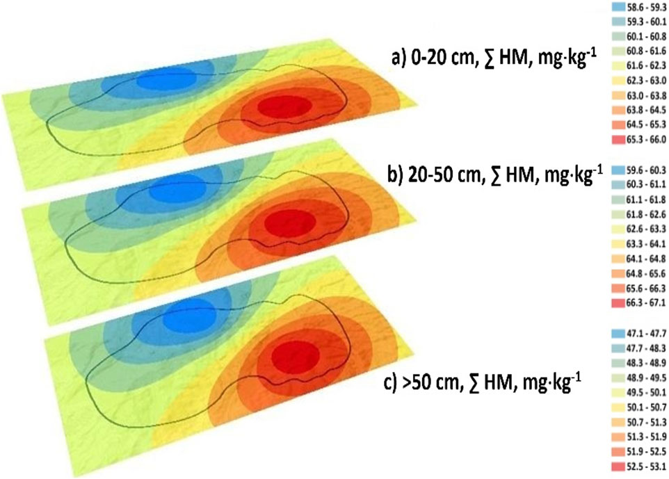
Figure 8. Distribution of total heavy metals content in soil horizons of the National Nature Park “Zacharovanyi Krai”.
The cluster analysis results indicate a strong correlation in the distribution of HMs within the National Natural Park “Uzhansky” (Figure 9a) and among themselves in the same territory (Figure 9b).
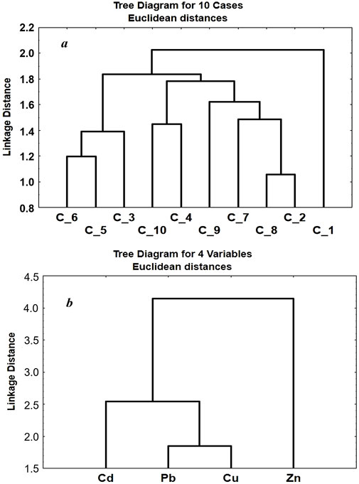
Figure 9. Results of the cluster analysis of HM distribution within the territory of the National Nature Park “Uzhansky” for ten soil samples C_1, C_2, … C_10 (a) and their correlation among themselves (b).
4 Discussion
The assessment of the background state across different landscape zones showed a fundamental difference in the distribution of radioactivity of RNs and HMs. Such patterns should be taken into account in the sustainable soil management system for organizing tourist, recreational, and agricultural activities.
In mountainous landscapes, natural radioactivity is significantly higher than in foothill and lowland landscapes. This is primarily due to the tectonics and geology of mountain landscapes (the flysch zone in the zone of rocks and the volcanic Carpathians), as well as the activity of the young Carpathian Mountains. High natural radioactivity in mountain landscapes can be considered as an ecological risk factor for both human health and the environment. Systematic stay in the zone of increased natural radioactivity and consumption of traditional mountain products, including mushrooms and wild berries (which have pronounced bioaccumulation), can affect human health and the biota as a whole. In addition, mountain meadows are used for grazing cows (Carpathian mountain breed) and sheep, and livestock products are traditional for the mountainous area (Migdał et al., 2022). Therefore, in our opinion, a diverse diet is important in mountainous areas.
The significant differences in indicators across various landscape zones highlight the established patterns of the radiological state of soils within nature reserves (background state of soils).
A higher content of HMs in soils is characteristic of lowland landscapes. Both geological factors and soil type, as well as the level of anthropogenic load on the territory, contribute to this. The territories adjacent are widely used for agricultural activities, so the relatively high content of HMs in the soils should be taken into account to ensure food safety. Of particular concern is the high migration index of lead in the soil humus profile, as acid-soluble forms of HMs can be considered as potentially bioavailable. This indicates a high ecological risk to biota and the environment. The reasons for this phenomenon are both anthropogenic activity and the relatively high acidity of the soil. Therefore, to prevent the accumulation of HMs, in particular lead, in biota, it is necessary to carry out artificial alkalization of agricultural lands.
Overall, the HM content in the soils of protected areas (National Nature Parks) is low and can be regarded as background levels for the soils of the Transcarpathian region, considering the various landscape zones.
5 Conclusion
Radiological indicators and heavy metal content assessed the current background state of the soils of the Tisza River Basin, which is the basis for sustainable soil management. The values of the background soil condition indicators for different landscape zones can be extended to adjacent territories, which will allow for more effective organization of tourist, recreational, and agricultural activities. It has been established that the significant difference in geological and tectonic conditions of the territories, as well as the type of soil for different landscape zones, causes a fundamental difference in the content and distribution of natural RNs and HMs in the soils. The results of cluster analysis confirmed the pronounced patterns of distribution of GAN and VM within the territories of the National Nature Parks.
In mountainous landscapes, the total radioactivity of natural radionuclides from the 238U and 232Th series—excluding 40K—is the highest, with the 238U series being the dominant component. This is clearly linked to the tectonic and geological activity of the Carpathian Mountains. High natural radioactivity in mountain landscapes can be considered as an ecological risk factor for both human health and the environment. In contrast, heavy metals are more prevalent in the soils of lowland landscapes. An assessment of the migration coefficient—determined by the ratio of acid-soluble forms (considered as potentially bioavailable) to the total content—reveals that the relatively high lead concentration in lowland soils results from anthropogenic influence (atmospheric deposition). This indicates a high ecological risk to biota and the environment. Therefore, when organizing agricultural activities, it is necessary to carry out partial artificial alkalization of soils.
Overall, this research has established background indicators for the soil conditions in the Tisza River Basin, which is a tributary of the Danube River.
Data availability statement
The original contributions presented in the study are included in the article/supplementary material, further inquiries can be directed to the corresponding author.
Author contributions
SS: Conceptualization, Writing – original draft, Validation, Methodology, Data curation. RM: Writing – original draft, Resources, Methodology, Conceptualization, Validation, Writing – review and editing. OS: Investigation, Software, Writing – original draft, Methodology, Formal Analysis, Visualization. TB: Formal Analysis, Writing – original draft, Methodology, Investigation.
Funding
The author(s) declare that financial support was received for the research and/or publication of this article. Sergii Sukharev is grateful to the National Scholarship Programme of the Slovak Republic for the Support of Mobility of students, PhD students, university teachers, researchers and artists, SAIA for the mobility grant (ID 54340).
Acknowledgments
The research project was supported by the National Scholarship Programme of the Slovak Republic for the Support of Mobility of students, PhD students, university teachers, researchers and artists, SAIA.
Conflict of interest
The authors declare that the research was conducted in the absence of any commercial or financial relationships that could be construed as a potential conflict of interest.
Generative AI statement
The author(s) declare that no Generative AI was used in the creation of this manuscript.
Publisher’s note
All claims expressed in this article are solely those of the authors and do not necessarily represent those of their affiliated organizations, or those of the publisher, the editors and the reviewers. Any product that may be evaluated in this article, or claim that may be made by its manufacturer, is not guaranteed or endorsed by the publisher.
References
Ahmad, A. Y., Al-Ghouti, M. A., AlSadig, I., and Abu-Dieyeh, M. (2019). Vertical distribution and radiological risk assessment of 137Cs and natural radionuclides in soil samples. Sci. Rep. 9, 12196. doi:10.1038/s41598-019-48500-x
Ali, M. H., Mustafa, A.-R. A., and El-Sheikh, A. A. (2016). Geochemistry and spatial distribution of selected heavy metals in surface soil of Sohag, Egypt: a multivariate statistical and GIS approach. Environ. Earth Sci. 75, 1257. doi:10.1007/s12665-016-6047-x
Allen, D. E., Singh, B. P., and Dalal, R. C. (2011). “Soil health indicators under climate change: a review of current knowledge,” in Soil health and climate change soil biology. Editors B. Singh, A. Cowie, and K. Chan (Berlin, Heidelberg: Springer), 29, 25–45. doi:10.1007/978-3-642-20256-8_2
Barbieri, M., Sappa, G., and Nigro, A. (2018). Soil pollution: anthropogenic versus geogenic contributions over large areas of the Lazio region. J. Geochem. Explor. 195, 78–86. doi:10.1016/j.gexplo.2017.11.014
Blum, W. E. H. (2005). Functions of soil for society and the environment. Rev. Environ. Sci. Biotechnol. 4, 75–79. doi:10.1007/s11157-005-2236-x
Briones, M. J. I. (2014). Soil fauna and soil functions: a jigsaw puzzle. Front. Environ. Sci. 2, 1–22. doi:10.3389/fenvs.2014.00007
de Matos, A. T., Fontes, M. P. F., da Costa, L. M., and Martinez, M. A. (2001). Mobility of heavy metals as related to soil chemical and mineralogical characteristics of Brazilian soils. Environ. Pollut. 111 (3), 429–435. doi:10.1016/S0269-7491(00)00088-9
do Carmo Leal, A. L., da Costa Lauria, D., Ribeiro, F. C. A., Viglio, E. P., Franzen, M., and de Albuquerque Medeiros Lima, E. (2020). Spatial distributions of natural radionuclides in soils of the state of Pernambuco, Brazil: influence of bedrocks, soils types and climates. J. Environ. Radioact. 211, 106046. doi:10.1016/j.jenvrad.2019.106046
Drobnik, T., Greiner, L., Keller, A., and Grêt-Regamey, A. (2018). Soil quality indicators – from soil functions to ecosystem services. Ecol. Indic. 94 (1), 151–169. doi:10.1016/j.ecolind.2018.06.052
Dung, T. T. T., Cappuyns, V., Swennen, R., and Phung, N. K. (2013). From geochemical background determination to pollution assessment of heavy metals in sediments and soils. Rev. Environ. Sci. Biotechnol. 12, 335–353. doi:10.1007/s11157-013-9315-1
Esmaeili, A., Moore, F., Keshavarzi, B., Jaafarzadeh, N., and Kermani, M. (2014). A geochemical survey of heavy metals in agricultural and background soils of the Isfahan industrial zone, Iran. Catena 121, 88–98. doi:10.1016/j.catena.2014.05.003
Esri (2019). ArcGIS webpage. Available online at: https://www.esri.com/software/arcgis (Accessed March 15, 2025).
Google (2025). Google Earth. Available online at: http://maps.google.co.uk (Accessed May 1, 2025).
Hseu, Z. Y., Chen, Z. S., Tsai, C. C., Tsui, C. C., Cheng, S. F., Liu, C. L., et al. (2002). Digestion methods for total heavy metals in sediments and soils. Water, Air, Soil Pollut. 141, 189–205. doi:10.1023/A:1021302405128
ISO (1998). Soil quality – determination of organic carbon by sulfochromic oxidation. Geneva, Switzerland: ISO.
ISO (2023). Soil quality – determination of potential cation exchange capacity (CEC) and exchangeable cations buffered at pH 7, using a molar ammonium acetate solution. Geneva, Switzerland: ISO.
Kardan, M. R., Fathabdi, N., Attarilar, A., Esmaeili-Gheshlaghi, M. T., Karimi, M., Najafi, A., et al. (2017). A national survey of natural radionuclides in soils and terrestrial radiation exposure in Iran. J. Environ. Radioact. 178-179, 168–176. doi:10.1016/j.jenvrad.2017.08.010
Kim, R.-Y., Yoon, J.-K., Kim, T.-S., Yang, J. E., Owens, G., and Kim, K.-R. (2015). Bioavailability of heavy metals in soils: definitions and practical implementation—a critical review. Environ. Geochem. Health. 37, 1041–1061. doi:10.1007/s10653-015-9695-y
Kumar, V., Sharma, A., Kaur, P., Sidhu, G. P. S., Bali, A. S., Bhardwaj, R., et al. (2019). Pollution assessment of heavy metals in soils of India and ecological risk assessment: a state-of-the-art. Chemosphere 216, 449–462. doi:10.1016/j.chemosphere.2018.10.066
Lal, R., Monger, C., Nave, L., and Smith, P. (2021). The role of soil in regulation of climate. Philos. Trans. R. Soc. Lond. B Biol. Sci. 376, 20210084. doi:10.1098/rstb.2021.0084
Mandujano-García, C. D., Sosa, M., Mantero, J., Costilla, R., Manjón, G., and García-Tenorio, R. (2016). Radiological impact of natural radionuclides from soils of Salamanca, Mexico. Appl. Radiat. Isot. 117, 91–95. doi:10.1016/j.apradiso.2016.01.031
Maslyuk, V. T., Symkanich, O. I., Svatyuk, N. I., Parlag, O. O., and Sukharev, S. M. (2016). The natural radioactivity of the Carpathian national parks and radon evaluation. Nukleonika 61 (3), 351–356. doi:10.1515/nuka-2016-0058
Migdał, W., Walczycka, M., Migdał, Ł., and Tabor, S. (2022). “Farm animals and traditional products of the carpathian Mountains,” in Cultural heritage—possibilities for land-centered societal development. Editors J. Hernik, M. Walczycka, E. Sankowski, and B. J. Harris (Cham: Springer), 209–228. doi:10.1007/978-3-030-58092-6_13
Morvan, X., Saby, N. P. A., Arrouays, D., Le Bas, C., Jones, R. J. A., Verheijen, F. G. A., et al. (2008). Soil monitoring in Europe: a review of existing systems and requirements for harmonisation. Sci. Total Environ. 391 (1), 1–12. doi:10.1016/j.scitotenv.2007.10.046
Nenadović, S., Nenadović, M., Kljajević, L., Vukanac, I., Poznanović, M., Mihajlović-Radosavljević, A., et al. (2012). Vertical distribution of natural radionuclides in soil: assessment of external exposure of population in cultivated and undisturbed areas. Sci. Total Environ. 429, 309–316. doi:10.1016/j.scitotenv.2012.04.054
Pikuła, D., and Stępień, W. (2021). Effect of the degree of soil contamination with heavy metals on their mobility in the soil profile in a microplot experiment. Agron 11 (5), 878. doi:10.3390/agronomy11050878
Rabot, E., Wiesmeier, M., Schlüter, S., and Vogel, H.-J. (2018). Soil structure as an indicator of soil functions: a review. Geoderma 314, 122–137. doi:10.1016/j.geoderma.2017.11.009
Saco, P. M., McDonough, K. R., Rodriguez, J. F., Rivera-Zayas, J., and Sandi, S. G. (2021). The role of soils in the regulation of hazardsand extreme events. Philos. Trans. R. Soc. Lond. B Biol. Sci. 376, 20200178. doi:10.1098/rstb.2020.0178
Sarkar, A., Deb, S., Ghosh, S., Mandal, S., Quazi, S. A., Kushwaha, A., et al. (2022). Impact of anthropogenic pollution on soil properties in and around a town in Eastern India. Geoderma Reg. 28, e00462. doi:10.1016/j.geodrs.2021.e00462
Schloter, M., Dilly, O., and Munch, J. C. (2003). Indicators for evaluating soil quality. Agric. Ecosyst. Environ. 98 (1-3), 255–262. doi:10.1016/S0167-8809(03)00085-9
Seo, B.-H., Kim, H. S., Kwon, S.-I., Owens, G., and Kim, K.-R. (2019). Heavy metal accumulation and mobility in a soil profile depend on the organic waste type applied. J. Soils Sediments 19, 822–829. doi:10.1007/s11368-018-2065-5
Şerban, G., Sabӑu, D., Bătinaş, R., Brețcan, P., Ignat, E., and Nacu, S. (2020). “Water resources from Romanian upper tisa Basin,” in Water resources management in Romania. Editors A. Negm, G. Romanescu, and M. Zeleňáková (Cham: Springer Water), 393–434. doi:10.1007/978-3-030-22320-5_12
Shyshkanynets, I., Zadorozhnyy, A., Potish, L., and Mihaly, A. (2024). The state and structure of beech primaeval forests in the “Zacharovanyi Krai” national nature park. Ukrainian J. For. Wood Sci. 15 (3), 8–24. doi:10.31548/forest/3.2024.08
Soodan, R. K., Pakade, Y. B., Nagpal, A., and Katnoria, J. K. (2014). Analytical techniques for estimation of heavy metals in soil ecosystem: a tabulated review. Talanta 125, 405–410. doi:10.1016/j.talanta.2014.02.033
Sukharev, S., Bugyna, L., Pallah(Sarvash), O., Sukhareva(Riabukhina), T., Drobnych, V., and Yerem, K. (2020). Screening of the microelements composition of drinking well water of Transcarpathian region, Ukraine. Heliyon 6 (3), e03535. doi:10.1016/j.heliyon.2020.e03535
Symkanich, O. I., Svatiuk, N. I., Maslyuk, V. T., Glukh, O. S., Sukharev, S. N., and Sherehiy, A. A. (2023). Radioecology monitoring system for mountine areas of the Tisza river basin (Transcarpathia, Ukraine). Problems Atomic Sci. Technol. 3 (145), 145–152. doi:10.46813/2023-145-145
Tan, K. H. (2005). Soil sampling, preparation, and analysis. 2nd ed. Boca Raton: CRC Press. doi:10.1201/9781482274769
Teng, Y., Wu, J., Lu, S., Wang, Y., Jiao, X., and Song, L. (2014). Soil and soil environmental quality monitoring in China: a review. Environ. Int. 69, 177–199. doi:10.1016/j.envint.2014.04.014
Ustymenko, P. M., Dubyna, D. V., and Davydov, D. A. (2022). The virgin forests of the synevyr national nature park, Ukraine: its current condition and biodiversity. Environ. Soc. Econ. Stud. 10 (4), 12–21. doi:10.2478/environ-2022-0020
Keywords: soil profiles, heavy metals, gamma-active radionuclides, national natural parks, landscape diversity, background monitoring
Citation: Sukharev S, Mariychuk R, Symkanych O and Babilia T (2025) Current background state of soils in the Tisza River Basin, Ukraine. Front. Environ. Sci. 13:1630121. doi: 10.3389/fenvs.2025.1630121
Received: 16 May 2025; Accepted: 16 June 2025;
Published: 26 June 2025.
Edited by:
Jose Antonio Rodriguez Martin, Instituto Nacional de Investigación y Tecnología Agroalimentaria (INIA), SpainReviewed by:
Aleksandar Valjarević, University of Belgrade, SerbiaFilip Jędrzejek, AGH University of Science and Technology, Poland
Naima Hidouri, Carthage University, Tunisia
Copyright © 2025 Sukharev, Mariychuk, Symkanych and Babilia. This is an open-access article distributed under the terms of the Creative Commons Attribution License (CC BY). The use, distribution or reproduction in other forums is permitted, provided the original author(s) and the copyright owner(s) are credited and that the original publication in this journal is cited, in accordance with accepted academic practice. No use, distribution or reproduction is permitted which does not comply with these terms.
*Correspondence: Ruslan Mariychuk, cnVzbGFuLm1hcml5Y2h1a0B1bmlwby5zaw==