 Yuwei Wang
 Yinghui Zhao*
- School of Public Administration and Law, Northeast Agricultural University, Harbin, China
As the core functional carrier of land resources, cultivated land has a dynamic feedback mechanism between its production, ecological and other functions, and land changes. Analyzing the trade-offs/synergies among cultivated land functions and formulating differentiated zoning control plans is of great significance for achieving sustainable utilization of the land system. Using grids as evaluation units, this paper quantitatively evaluates the production function, living security function, ecological function, and landscape function of the cultivated land in the Sanjiang Plain for 2005, 2010, 2015, and 2020. The Spearman correlation coefficient method and the bivariate spatial autocorrelation analysis method are adopted to reveal the trade-off/synergy among various functions of the cultivated land. Functional zoning is carried out through self-organizing mapping (SOM) to explore the dynamic evolution of each functional zone and propose corresponding development goals and optimization strategies. The findings indicate that: (1) Between 2005 and 2020, the production function continued to increase, and the living security, ecological, and landscape functions showed a trend of fluctuating increase. (2) There are significant trade-offs or synergy relationships among various functions. The functional synergy between the production-living security function and the production-landscape function is most significant. The trade-off between ecological and production functions is the most prominent. (3) This paper innovatively proposes to divide the Sanjiang Plain into six types of cultivated land functional areas, namely, the agriculturally balanced development area; the agro-ecological leisure area; the eco-agricultural development area; the agricultural potential improvement area; the agricultural production-dominated area; and the agricultural living security area, and constructively puts forward the development countermeasures for each functional area. The research results not only reflect the dynamic changes in the functions of cultivated land in the Sanjiang Plain, but also the functional zoning results can provide a scientific basis for the differentiated management and control of regional cultivated land.
1 Introduction
As the primary vehicle of food production and an artificial-natural composite ecosystem, cultivated land provides necessary guarantees and services for the sustainable development of human society (Lu et al., 2024). Influenced by various factors such as socio-economic transformation, evolving human demand levels, and advancements in functional cognition, the roles associated with cultivated land have transcended the traditional focus on agricultural production. Its multifunctionality has become increasingly prominent (Lai et al., 2020; Liu et al., 2023). On an international scale, the importance attached to the multifunctionality of cultivated land has been increasing globally. The Food and Agriculture Organization of the United Nations (FAO) underscores the necessity of acknowledging the multifaceted characteristics of cultivated land to uphold social order and foster stable development within rural communities. The Common Agricultural Policy (CAP) of the European Union also reflects the concern for functions such as the production, nutrient cycling, and climate regulation of cultivated land (Schröder et al., 2020). However, for an extended period, China’s cultivated land utilization strategy has been restricted by a unidimensional functional orientation, resulting in significant limitations in both the theoretical development and practical application of multidimensional function integration and coordination mechanisms within the cultivated land system (Li et al., 2023; Wang M. et al., 2024). This has led to complex problems such as soil degradation, overloading of ecological carrying capacity and loss of biodiversity (Zou et al., 2025; Sommer et al., 2023). The diversification and synergistic development of cultivated land functions aligns closely with the core principles of the United Nations Sustainable Development Goals (SDGs), and represents a central strategy for enhancing the resilience of cultivated land systems and promoting the integration of agricultural industries (Zhang S. et al., 2019).
The concept of multifunctionality in cultivated land stems from the broader theoretical framework of agricultural multifunctionality (Xiang et al., 2024; Long et al., 2022; Klein et al., 2014). Continuing within the research framework, most scholars argue that multifunctionality is an inherent attribute of farmland. This attribute addresses human development needs by integrating material, spatial, and functional aspects, thereby supporting the attainment of multidimensional human wellbeing (Jiang et al., 2020). Furthermore, studies have explored its categorized evaluation, trade-offs and synergies, and spatial zoning optimization. Regarding the categorized evaluation, early research primarily concentrated on the ecological, economic, and production dimensions (Chen et al., 2025), while later research is grounded in an integrated perspective that encompasses “production-living-ecology” (Yin et al., 2023; Fang et al., 2025). With the deepening of the research, the classification criteria and evaluation methods tend to be diversified. Based on a comprehensive utilization perspective, many studies evaluates using integrated approaches, including multi-objective decision-making, the entire array-polygon indicator index, and the composite index method (Ma and Jin, 2018; Jiang et al., 2020). The relationships among cultivated land functions are multiple and nonlinear, which can be broadly classified into competitive trade-offs and mutually reinforcing synergies (Zhang Y. et al., 2019; Liang and Li, 2020). At present, methods such as root mean square error (RMSE), bivariate spatial autocorrelation analysis method, correlation coefficient method, land function trade-off/synergy degree (LFTD), and difference comparison method are widely employed to examine the relationships between pairs of cultivated land functions (Bao et al., 2024; Wang X. et al., 2023; Fan et al., 2023), or the coupling coordination model is used to analyze the coordination level among multiple functions (Zhang et al., 2018; Liu et al., 2024). In zonal management, the K-means clustering method, normalized revealed comparative advantage (NRCA), or spatial overlay method is mostly adopted (Zhang J. et al., 2022). The current research still has potential for further refinement. In terms of the selection of the research scope, there are relatively abundant research achievements with administrative units as the research scope, while the research carried out based on natural geographical units is relatively insufficient (Luo et al., 2025). In zoning studies, current research primarily focuses on conducting zoning based on the cultivated land functions at a specific point in time, treating these functions as static attributes. Zoning efforts have failed to effectively incorporate spatiotemporal dimensions, resulting in a limited understanding of the dynamic evolution of functional zones and making it difficult to meet the increasingly complex demands of cultivated land management in practice (Yang et al., 2024). In the zoning method, the commonly used K-means clustering method currently has certain limitations. That is, when there are outliers in the data, the clustering centers are easily disturbed, resulting in the clustering results deviating from the real data distribution. In contrast, the Self-Organizing Map (SOM), through its competitive learning mechanism, can more objectively reveal the distribution characteristics of the data, offering a scientific and reliable basis for the zoning work.
The Sanjiang Plain, often referred to as the “Northern Granary,” is dominated by black soil types, making it one of China’s most important commercial grain production bases and one of the few globally recognized high-productivity agricultural regions. In recent years, the region has faced multiple challenges in land protection, food production, and ecological construction, leading to a reduction in ecological space and degradation of land quality (Dai et al., 2024; Xu et al., 2024). To address this dilemma, it is imperative to transcend the conventional view of cultivated land as serving solely a production function and instead promote its multifunctional and integrated use. In light of these circumstances, systematically evaluating the cultivated land functions and studying the interaction patterns between them have become a common approach to improving land quality and coordinating sustainable socio-economic and ecological development. This study, based on a grid scale, systematically explores the spatio-temporal evolution characteristics of the production, living security, ecological and landscape functions of cultivated land in the Sanjiang Plain from 2005 to 2020, and analyzes the trade-offs and synergies among these functions. Finally, this paper uses the Self-Organizing Map (SOM) method for functional zoning, analyzes the dynamic evolution trends of each region, and combines the actual situation to put forward targeted management suggestions.
2 Study area and data sources
2.1 Study area
The Sanjiang Plain is in the northeastern part of Heilongjiang Province, China. Its geographical scope ranges from 45°01′00″N to 48°27′56″N and from 130°13′00″E to 135°05′26″E. It includes a total of 22 cities (counties), namely, Jiamusi City, Hegang City, Shuangyashan City, Qitaihe City, Jixi City, and Yilan County under Harbin City (Figure 1). The Sanjiang Plain mainly consists of cultivated land in terms of land use type. It is rich in cultivated land resources with excellent quality and belongs to a typical black soil area. Compared with 2005, the grain output of the Sanjiang Plain increased by 2.78 times in 2020, accounting for approximately 35% of Heilongjiang Province’s total grain output—1.28 times the proportion in 2005 (Table 1).
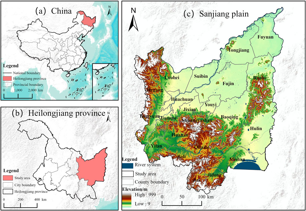
Figure 1. General Maps of the Study Areas (a) China, (b) Heilongjiang Province, (c) The Sanjiang Plain.
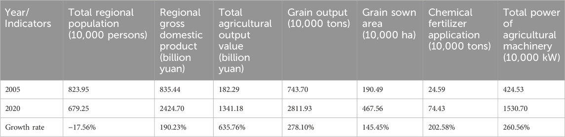
Table 1. Overview table of the Sanjiang plain.
2.2 Data sources and preprocessing
The research data mainly involves the geospatial dataset and socio-economic data of cities (counties) in the Sanjiang Plain in 2005, 2010, 2015, and 2020. The geospatial data are mainly as follows: The NPP data are sourced from the Resource and Environment Science Data Platform, with a spatial resolution of 500 m (https://www.resdc.cn/). The GDP data are sourced from the Resource and Environment Science Data Platform, with a spatial resolution of 1 km (https://www.resdc.cn/). The NDVI data are from the MOD13A3 dataset (https://www.earthdata.nasa.gov/), with a spatial resolution of 1 km. The population density data are from Landscan (https://landscan.ornl.gov), with a spatial resolution of 1 km. The land use data are from the Land Use and Cover Dataset (CLCD) of Wuhan University, with a spatial resolution of 30 m (Yang and Huang, 2021). To ensure data uniformity and the accuracy of research results, this study takes land use data as the benchmark and resamples data of various resolutions through nearest resampling techniques. This method determines the new value of a pixel by identifying the center position of the nearest pixel on the input raster. It is applicable to both discrete and continuous data and has wide applicability. The socio-economic data are acquired from the statistical yearbooks and statistical bulletins of cities and counties in 2006, 2011, 2016, and 2021.
3 Research methods
3.1 Evaluation index system
As a natural-economic-social complex, cultivated land possesses the most fundamental productive and ecological functions. Moreover, as the level of social and economic development continuously advances, it also assumes additional roles such as living security and landscape enhancement, which have evolved from its basic functions. Considering the multifunctionality and hierarchical nature of cultivated land, the following evaluation index system is conducted, which includes 4 target levels and 16 index levels, from four dimensions: production, living security, ecology, and landscape (see Table 2).
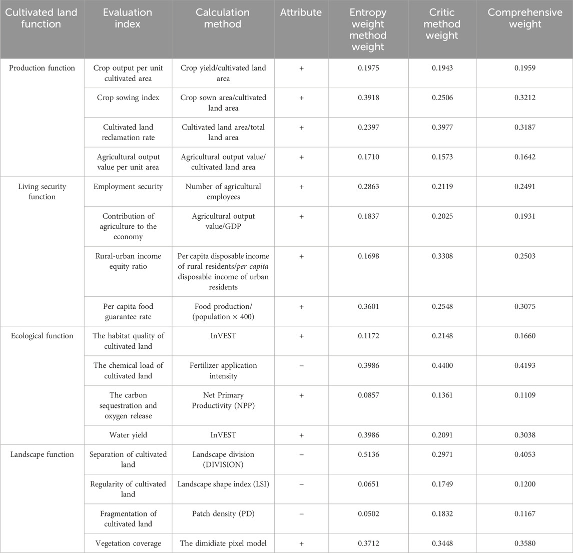
Table 2. Evaluation index system for the multifunctions of cultivated land in the Sanjiang plain.
3.1.1 Production function (PF)
As a key material basis for grain production, the production function of cultivated land constitutes its core and essential attribute. This study selects crop output per unit cultivated area, crop sowing index, agricultural output value per unit area, and cultivated land reclamation rate as the main characteristic indicators (Wu et al., 2023). Among them, crop output per unit cultivated area can intuitively indicate the output capacity of cultivated land in the actual agricultural production process. It reflects the effectiveness of cultivated land in material production through the specific output quantity of crops. The crop sowing index indicates the production scale of cultivated land. The land reclamation rate reflects, to some extent, the scale of the agricultural production foundation. The agricultural output value per unit area indicator indicates the capacity of cultivated land to generate economic benefits during agricultural production.
3.1.2 Living security function (LSF)
Cultivated land embodies its living security function in the dimensions of employment, economy, and food security by providing farmers with employment opportunities, economic income, and guaranteeing stable food reserves (Wang et al., 2020a). In this study, the number of agricultural employees is selected as an indicator of the role of cultivated land in employment security, as it directly reflects the ability of cultivated land to create job opportunities. (Zhou et al., 2025). The contribution of agriculture to the economy and the rural-urban income equity ratio are selected to demonstrate the critical role of arable land in supporting rural economic development and improving farmers’ income levels (Cai et al., 2022; Wang H. et al., 2023). The per capita food guarantee rate is used to assess the role of cultivated land in ensuring food security, thereby revealing the strength of its support from the perspective of grain supply capacity.
3.1.3 Ecological function (EF)
The ecological function of cultivated land is reflected in its role as a component of the natural ecosystem. Through ecological processes such as material cycling, energy flow, and providing habitats for organisms, it offers various ecological products and services to humanity. To accurately reflect the ecological functions, the following indicators were selected. The habitat quality index is used to measure the extent to which cultivated land guarantees the suitability of habitats. With the help of the chemical load indicator to represent the potential pressure and negative effects borne by cultivated land under the input of chemicals (Wu et al., 2023). The carbon sequestration and oxygen release indicator are used to reflect the carbon sink efficiency of cultivated land in the carbon cycle process and its important contribution to mitigating climate change (Qian et al., 2020). The water yield indicator is employed to reflect the role of cultivated land in maintaining regional water balance and supporting vegetation growth (Yang et al., 2024).
3.1.4 Landscape function (LF)
As people’s needs diversify and rural tourism flourishes, cultivated land, a key component of agritourism landscapes, has attracted more and more attention for its aesthetic value and landscape function. The landscape function belongs to the subjective value construction of the interaction between people and places. Research shows that the landscape pattern characteristics can reflect human visual preferences and aesthetic tendencies to a certain extent, providing an objective path for quantifying subjective perception. Based on the aspects such as the resource scale, aggregation characteristics, boundary regularity, and green environment of the landscape, this paper constructs an evaluation index system (Wang H. et al., 2023; Liu et al., 2024). The fragmentation of cultivated land, the regularity of cultivated land, the separation of cultivated land, and the vegetation coverage are selected as the main evaluation indicators to represent the landscape function of cultivated land.
3.2 Comprehensive evaluation of the cultivated land functions
Based on the evaluation index system for the cultivated land multifunctions, this study first establishes a grid at an appropriate scale to spatialize socio-economic data and conducts dimensionless processing of each functional evaluation index through the index standardization method to ensure data comparability. Then, the CRITIC-entropy weighting method is applied to calculate the weights. Finally, a comprehensive weighting method is employed to calculate the functional indices of cultivated land.
3.2.1 Spatialization of socio-economic data
Concerning relevant literature and taking fully into account the physical geography and socio-economic characteristics of the study area, this research selects a grid of 5 km × 5 km as the basic unit for evaluation (Qi et al., 2019; Li et al., 2022). After determining the appropriate scale of the grid, relevant research is referred to in order to realize the spatialization of socio-economic data. Among them, crop output, agricultural output value, and per capita food guarantee rate refer to relevant research (Yang et al., 2024), while the remaining indicators use the following Formula 1 to spatialize socio-economic data at the city (county) level into each grid.
In the formula,
3.2.2 Index standardization
The evaluation index system covers many aspects such as production, economy, and society. Given the differences in data units and directions across the indices, normalization of the data is performed to improve their comparability and ensure the accuracy of the evaluation results.
Positive Indicator can be expressed by Formula 2
Negative Indicator can be expressed by Formula 3
In the formula,
3.2.3 Weight determination
The CRITIC objective weighting method objectively assigns weights to indicators through the contrast intensity and conflict between indicators, while the entropy weight method determines the indicator weights through the degree of variation of the data itself. Through the combination of two methods for weight determination, the uncertainty caused by data characteristics when using a single method can be reduced, enhancing the robustness of the evaluation results.
The CRITIC objective weighting method can be expressed by Formulas 4, 5.
Where
The entropy weight method can be expressed by Formulas 6–8.
In the formula,
The Comprehensive Weight method can be expressed by Formula 9.
In the formula,
3.2.4 Calculation of the functional values of cultivated land
Calculated primarily using the integrated weighting method and the calculation Formula 10 is:
In the formula,
3.3 Analysis of the trade-off/synergistic relationship of the multi-functions of cultivated land
3.3.1 Spearman correlation coefficient
The Spearman rank correlation coefficient’s sign and magnitude can be used to examine the synergies and temporal trade-offs between the various cultivated land functions. Specifically, the nature of the relationship between two functions is determined by the sign (positive or negative) of the coefficient, while the strength of the relationship is assessed based on the magnitude of the coefficient (Li et al., 2025), as shown in Formula 11.
In the formula,
3.3.2 Bivariate spatial autocorrelation analysis method
Bivariate spatial autocorrelation can quantify the spatial association and clustering characteristics between variables, thereby revealing the relationship between them, as shown in Formula 12.
In the formula,
3.4 Self-organizing map (SOM) analysis
The Self-Organizing Map, also known as the Self-Organizing Neural Network, is an unsupervised artificial neural network proposed by Finnish scholar Kohonen in the 1980s (Kohonen, 1982). It classifies sample data through a competitive mechanism and outputs the best-fitting category while maintaining the topological structure of the data. This model is composed of a two-layer neural network. The input layer receives preprocessed data and finds out the winning neuron through competition, its neighboring neurons adjust the weight vector according to the rules. Through iterative training, the output layer adapts its weight vectors to fit the data distribution to achieve functions such as clustering and feature extraction. We utilized the “kohonen” package in R 4.4.3 to train a 3 × 2 rectangular neuron grid for 500 iterations with a decaying learning rate to achieve the mapping of the feature space. The weight vector update is shown in Formulas 13–15.
In the formula,
In the formula,
4 Results
4.1 Temporal and spatial evolution characteristics of cultivated land multifunctions
Based on the evaluation index system, this section performs a spatio-temporal dynamic analysis of the cultivated land functions in the Sanjiang Plain from 2005 to 2020. To compare the spatial changes of the various cultivated land functions, these functions were classified into five levels (Gao et al., 2022): the low-value area (0, 0.2], the sub-low-value area (0.2, 0.4], the medium-value area (0.4, 0.6], the sub-high-value area (0.6, 0.8] and the high-value area (0.8, 1]. The specific results are shown in Figure 2.
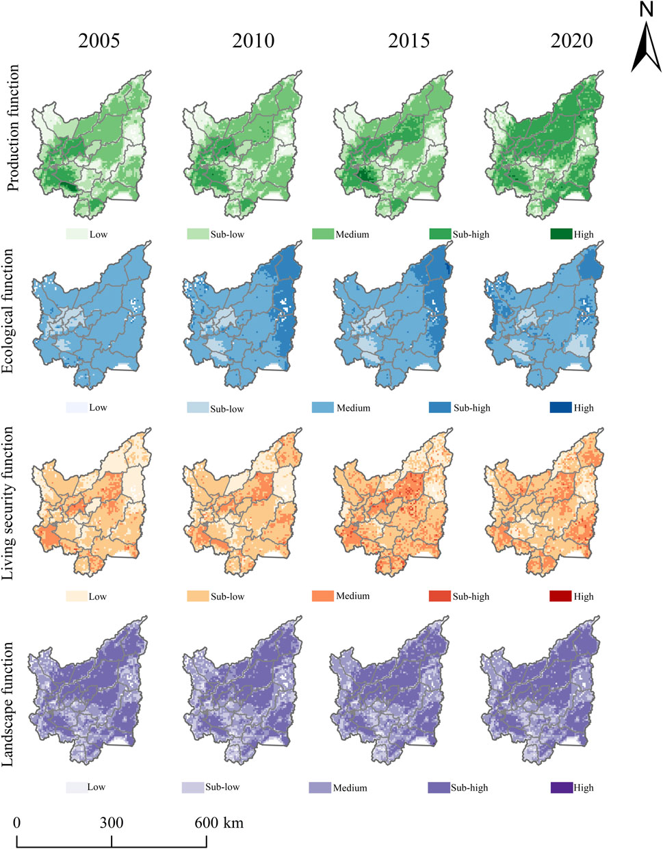
Figure 2. Spatial distribution map of the multi-functions of cultivated.
Regarding production function, it showed an increasing trend over time, with the average value steadily rising from 0.3710 in 2005 to 0.5074 in 2020, representing an increase of 36.68%. In 2020, the area of high-value areas reached 3.61 times that of 2005 and replaced medium-value areas to become the primary area. Spatially, the southwestern region had a relatively high production function in 2005. By 2020, the scope of the high-value areas had significantly expanded. Northern cities such as Fuyuan and Tongjiang, as well as southeastern cities like Hulin and Mishan, had become high-value areas for production function.
The living security function exhibited a fluctuating trend of initial increase followed by a slight decline, but with an overall upward tendency. The average function value increased from 0.2602 in 2005 to 0.3264 in 2015, but dropped to 0.3138 in 2020, with an increase of 20.60%. In 2020, the overall functional level was predominantly composed of sub-low- and medium-value areas, accounting for 83% of the study area. Compared to 2005, the extent of the low-value regions decreased by 51%. Spatially, the distribution follows a “high on the edges, low in the center” pattern, with low-value areas concentrated in Shuangyashan and Qitaihe. Meanwhile, key grain-producing areas like Hulin, Mishan, and Fujin primarily exhibit medium-value function levels.
Ecological function exhibited an inverted “U”-shaped trend over time. The mean value rose from 0.4886 in 2005 to 0.5329 in 2010, and then dropped to 0.5070 in 2020. Spatially, the ecological function was predominantly characterized by medium-value areas. In 2005, areas such as Huachuan and Jixian, located in the western-central part of the region, exhibited low values. From 2010 to 2015, the extent of sub-high-value areas expanded in the northeast, covering regions such as Fuyuan, Raohe, and Hulin. By 2020, the low-value areas in the southeast had further expanded.
The landscape function exhibited a pattern of initial fluctuation followed by continuous growth. The average value dropped from 0.5293 in 2005 to the lowest value of 0.5112 in 2010, and then continuously rose to 0.5895 in 2020, representing an 11% growth from 2005. The spatial variation of landscape function was relatively small, with high- and medium-value areas collectively accounting for 77% of the study area. These areas were predominantly located in the northern regions, including Fuyuan, Tongjiang, Fujin, and Suibin, as well as in the southwestern regions such as Hulin and Mishan.
4.2 The multifunctional synergy/trade-off relationship of cultivated land
4.2.1 Temporal evolution characteristics of the trade-off/synergy
Based on the quantitative evaluation results of each function, this study systematically analyzed the temporal evolution characteristics of trade-offs/synergies among the functions by using the Spearman rank correlation coefficient method, and obtained the following results: all six combinations composed of the four functions of cultivated land met the significance criterion at the 0.01 level throughout the study period. This finding indicates a notable statistical significance (Figure 3).
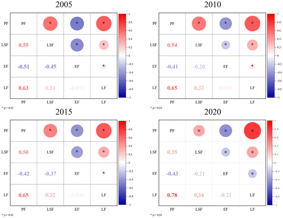
Figure 3. Spearman correlation coefficient among various functions.
Over the past 15 years, the trends in the temporal changes of trade-off and synergy among different arable land functions have been inconsistent. Among them, the production-living security functions have always maintained a significant synergistic relationship. However, the correlation coefficient showed a decline, decreasing from 0.55 in 2005 to 0.35 in 2020—a 36% drop. In contrast, the production-ecological functions generally exhibited a trade-off. Between 2005 and 2010, the correlation coefficient rose from −0.51 to −0.41, and in 2020, it dropped to −0.43, indicating a 15% weakening of the negative correlation during the study period as a whole. Additionally, the production-landscape functions showed a continuously strengthening positive synergy that continued to strengthen over time, with the correlation coefficient remaining steadily between 0.63 and 0.78. The living security-ecological functions exhibited a trade-off, and the correlation coefficient shows a fluctuating evolution trend in the shape of an inverted “N.” After fluctuating from −0.45 in 2005, it rebounded to −0.21 in 2020. The living security-landscape functions exhibited a positive synergy that continued to strengthen, with the correlation coefficient showing an upward trend from 0.24 in 2005 to 0.34 in 2020, a 41% increase. Finally, the ecological and landscape functions alternated between trade-off and synergy. The two showed a trade-off in 2005, shifted to synergy with a correlation coefficient of 0.096 in 2010, and reverted to a trade-off as the coefficient dropped to −0.21 in 2020.
4.2.2 Spatial evolution characteristics of the trade-off/synergy
This section further investigates the spatial evolution characteristics of trade-offs/synergies among the functions through the bivariate spatial autocorrelation method. The six trade-offs and synergies formed by the four functions of arable land in the Sanjiang Plain exhibit spatial heterogeneity (Figures 4, 5).
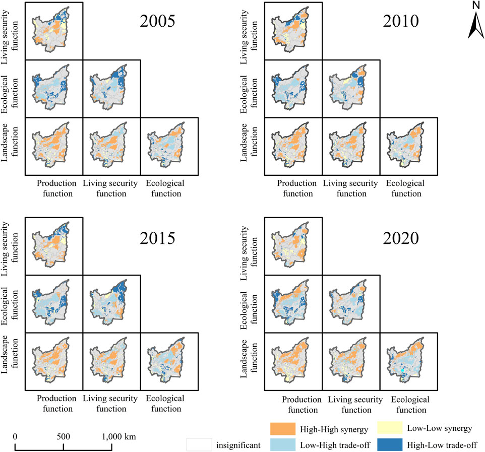
Figure 4. Spatial trade-off/synergy relationship among cultivated land functions.
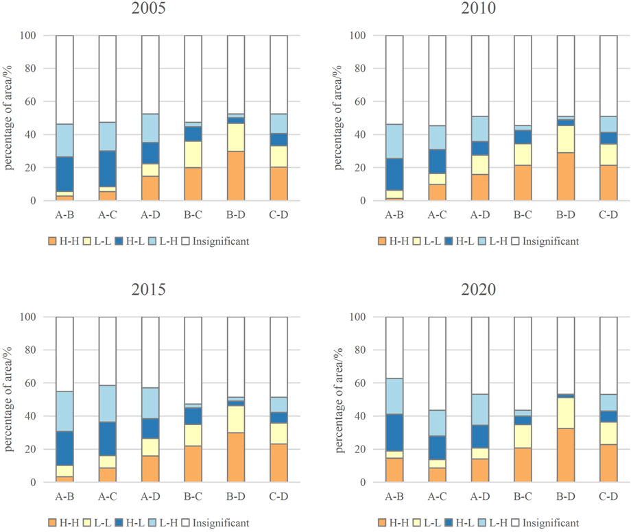
Figure 5. Proportion of the area of the trade-off/synergy relationship among the multi-functions of cultivated land (Where A is the EF, B is the PF, C is the LSF, and D is the LF).
The proportion of H-H synergy areas for production-living security functions is approximately 20%. In 2005, these areas were mainly concentrated in Fulin, Baoqing and Yilan, among others. By 2020, the area of H-H synergy areas in the northeastern part of Mishan and Hulin had significantly increased. The L-L synergy areas are mainly distributed in southern Raohu, Qitaihe and other places. In addition, the area of the trade-off areas decreased from 12% in 2005 to 8% in 2020, being mainly concentrated in the northeastern part of Raohu and Tongjiang, and scattered in Shuangyashan.
The number of trade-off areas for the ecological-production function was significantly higher than that of synergy areas in 2005, but the synergy areas have expanded in the later stage. Among them, the H-H synergy areas grew in a band-like pattern in the west and were distributed in Raohe, Suibin, and eastern Luobei in 2020. The L-L synergy areas were relatively few and mainly located in Jixi. The H-L trade-off areas were mostly located in Hegang and western Luobei. The L-H trade-off areas were scattered, with the majority in Fujin, Youyi, Jixian, Hunchuan and Huanan.
The synergy areas of production-landscape function dominate the study area, accounting for approximately 50% of its total area. The H-H synergy areas are widely distributed in the north-central part, the southwest, and Hulin City of the area. The L-L synergy areas are relatively scattered, mostly located in the southern region with more undulating terrain. Compared with 2005, the number of trade-off areas in 2020 decreased by 65%, and the area was sporadically distributed in the peripheral areas of the study area.
The ecological-living security function is mainly characterized by trade-off areas, with L-H trade-off areas mostly distributed in Hulin and Fujin, and H-L trade-off areas mainly concentrated in the central region. In 2005, H-H synergy areas were scattered in Yilan and Boli in the southern region. In 2010, they shifted to Fuyuan and Hulin in the northeast. In 2020, they were more scattered but showed an aggregated state in Fuyuan, Yilan, Luobei, and other places. The L-L synergy areas were initially concentrated in Suibin, but later the function of this area improved, turning it into a non-significant area.
The living security-landscape function has seen a significant upward trend in its synergy areas. Its spatial pattern shows certain similarities with that of the production-landscape function. The H-H synergy areas are mainly in the central-northern region, exhibiting agglomeration in Fuyuan, Fujin, Luobei, and Hulin. The L-L synergy areas are mostly located in the central-southern and marginal regions. The L-H trade-off areas are interlaced with the H-H synergy areas in the north. The majority of the H-L trade-off areas are distributed in Jixi, with some are scattered in the southern part of the study region.
The synergy areas of the ecological-landscape function exhibited a trend of first increasing and then decreasing. In 2020, the H-H synergy areas were mainly distributed in a band-shaped pattern in the northwestern part of the study area, encompassing Fuyuan, Tongjiang, Suibin, and western Luobei. The number of trade-off areas increased during the study period. Specifically, the number in 2020 increased by 53% compared to 2005. Spatially, most of the areas exhibited a scattered distribution, though some concentration was observed in Hulin, Baoqing, Fujin, and Huachuan.
4.3 Functional zoning of cultivated land and its spatiotemporal evolution
This study integrates the SOM with multifunctional evaluations of cultivated land to classify spatial units within the study area, enabling a more nuanced understanding of regional disparities. The results show that when the number of clusters is 6, there are substantial differences among the functional clusters, while within-cluster variation remains relatively low (Figure 6).
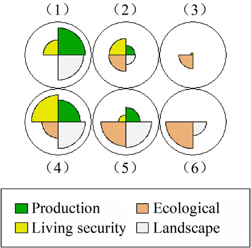
Figure 6. Clustering results of the functions of cultivated land in the Sanjiang plain.
Then, by analyzing the performance characteristics of each cultivated land function within each functional cluster, a differentiated functional zoning system for cultivated land is scientifically defined (Table 3). The spatial distribution patterns of cultivated land functional zones for each year are shown in Figure 7.
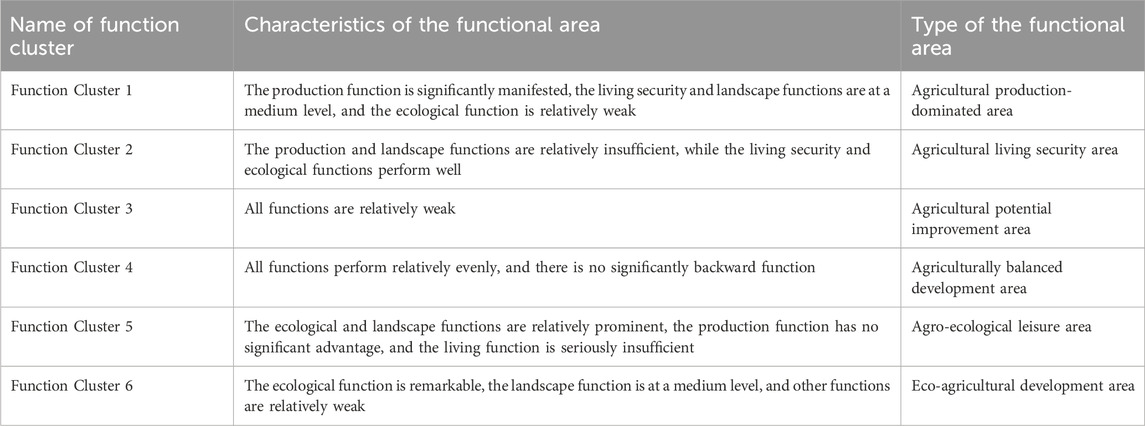
Table 3. Functional zoning system of cultivated land.
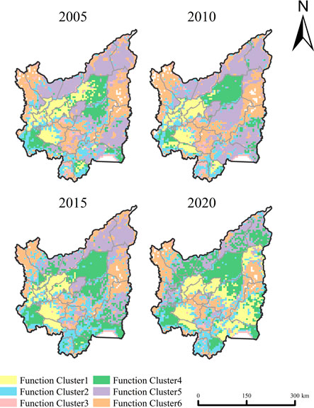
Figure 7. Temporal and Spatial evolution of the function clusters of cultivated land in the Sanjiang plain.
The number of agricultural production-dominated areas has shown a steady increase over the years. From 2005 to 2015, these areas were primarily distributed in Huachuan, Huanan, Jixian, and Fujin. By 2020, the distribution range of these areas had further extended eastward, encompassing Mishan, Hulin, Baoqing, and northern Raohe, and was concentrated in the central-northern plain belt with a high reclamation rate. The number of agricultural living security areas has gradually increased, mainly concentrated in Jidong, Yilan, and Jixi in the south, and sporadically distributed in places such as Tangyuan and Baoqing. The agricultural potential improvement areas are predominantly in the peripheral zones and along the borders between cities and counties. These regions have relatively scarce arable land resources and the land is fragmented and scattered, resulting in relatively low performance of land functionality. The number of agriculturally balanced development areas has shown a significant growth trend during the study period. Their spatial distribution exhibits the following characteristics. In 2005, these areas were mostly distributed in Yilan, Fujin, and Baoqing, accounting for approximately 13% of the study region’s total area. In 2020, they expanded towards the north, and multiple regions in Fuyuan, Tongjiang, and Suibin changed from agro-ecological leisure areas to agriculturally balanced development areas. In 2020, the area of the agriculturally balanced development areas accounted for 25% of the total area of the study region, representing an 88% increase compared with that in 2005. The agro-ecological leisure areas were initially concentrated in the northern region, including Fuyuan, Tongjiang, Suibin, Luobei, and Youyi, as well as in the southeastern region, including Hulin and Mishan. Since 2015, the number of agro-ecological leisure areas has shown a continuous decreasing trend. By 2020, their proportion had dropped to 12% of the total area, with most transformed into agriculturally balanced development areas and agricultural production-dominated areas. The number of eco-agricultural development areas showed an upward trend between 2005 and 2010. The number reached its peak in 2010, representing 24% of the total regional area. They were mostly distributed in Hegang and Luobei in the western part, Raohe in the eastern part, as well as Shuangyashan and Qitaihe in the central part. The number of such areas significantly declined between 2010 and 2020. As of 2020, this area represented only 12% of the total study region, marking a 21% decline from 2005.
5 Discussion
5.1 Applicability of cultivated land multifunction index system and evaluation results
The multi-functional evaluation of cultivated land lacks a standardized paradigm, with functional emphases and forms varying across different stages. Current research primarily focuses on the dual attributes of cultivated land: first, its intrinsic role as the core carrier for agricultural production and a critical component of the natural ecosystem, supporting fundamental functions such as food production and material cycling; second, its derived added value, encompassing diverse services like agricultural landscape aesthetics and rural social security. Based on the results of the functional evaluation, it can be concluded that the production function of cultivated land has shown a year-on-year increasing trend, with high-value areas predominantly concentrated in regions such as Fujin, Hulin, and Mishan. These regions feature abundant cultivated land resources and a high reclamation rate, and the extensive crop-sowing areas contribute to relatively high unit-area grain yields. However, in central-southern areas with poor topographical conditions, the production function cannot be fully realized due to the scattered distribution of cultivated land, significant terrain undulations, and steep slopes. Constrained by terrain and natural resource endowments, it is difficult to fully unleash the cultivated land production function, which is similar to Tan’s research results (Tan et al., 2021).
The living security and landscape functions also have shown an upward trend, which is most likely closely related to measures such as the well-facilitated farmland projects vigorously promoted by the government and the continuously increasing agricultural investment (Figure 8). The abolition of the agricultural tax in 2006 led to a continuous increase in the per capita disposable income of farmers. In addition, the General Rules for the Construction of Well-Facilitated Farmland were issued in 2014. By consolidating fragmented plots into standardized fields suitable for mechanized operations, this construction has improved production conditions and contributed to the optimization of rural living environments (Liu et al., 2022; Yusheng et al., 2023). Spatially, the living security function in the central part was relatively low, mainly due to the better economic development in this region. The advancement of the new urbanization plan in 2014 accelerated the development of secondary and tertiary industries, releasing a large number of non-agricultural jobs with more attractive salaries. This led to a decrease in farmers’ comparative income from grain cultivation and a continuous weakening of cultivated land’s employment security capacity. This is similar to the results of the cases in the Poyang Lake Plain and the Dongting Lake area (Xiang et al., 2024; Zhang et al., 2023).
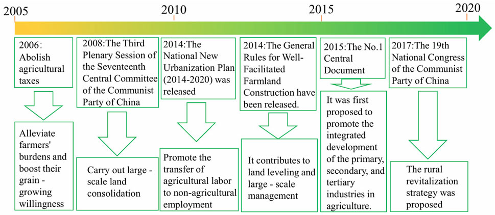
Figure 8. The evolution of policies from 2005 to 2020.
Although China integrated ecological civilization construction into its national strategy in 2012 and enhanced habitat quality through ecological restoration, the concept of extensive agricultural development has not been fully transformed. This has led to prominent issues of excessive chemical fertilizer and pesticide use, resulting in a decline in ecological functions at a later stage (Song et al., 2022). This phenomenon may also cause issues such as soil pH imbalance and heavy metal accumulation, which are closely linked to land degradation risks. This reflects certain limitations in the current indicator system. This study on ecological functions is only confined to functions related to macro-ecological cycles, such as climate regulation and biodiversity, and lacks exploration of micro-indicators like soil health, which are of great significance for the operation of the internal ecosystem of cultivated land. Direct soil indicators are currently absent from the indicator system, which may lead to biases in assessing regional black soil degradation risks and thus hinder the full revelation of the deep ecological impacts of extensive agriculture. This represents an important direction for future research. In landscape function evaluation, although the objective index system supported by geographic information technology has mature application value, pure objective data is difficult to represent the hidden demands and dynamic perception of society. In the future, public perception data should be obtained via methods such as questionnaires and in-depth interviews to construct a landscape function evaluation system with dual dimensions of “spatial structure-social perception.”
5.2 Analysis of trade-off/synergy among cultivated land multifunctions
In terms of trade-off/synergy relationships, the ecological function shows a certain degree of trade-off with the production, living security, and landscape functions. This suggests that the previous blind pursuit of high grain yields and extensive land use in the Sanjiang Plain has compromised the ecological functions of farmland. The conclusions align with the findings of Zhang, Liu, and Fang, who emphasized the ecological harm caused by an excessively high proportion of intensive agriculture (Liu et al., 2020; Zhang X. et al., 2022; Fang et al., 2025). The trade-off between ecology and landscape is similar to the situation in Shenyang (Qian et al., 2020). This can be attributed to the unreasonable use of chemical fertilizers, which causes non-point source pollution, damages surrounding vegetation habitats, and impairs the landscape function. Whether in Latin America or Africa, overly intensive agricultural production has triggered numerous environmental problems, which impact the global environment and cultural ecosystems (Flachsbarth et al., 2015; Pereira et al., 2025). This indicates that the production-ecology conflict is a problem commonly existing in the world’s intensive agricultural regions.
The production-living security functions have always maintained a synergistic relationship, confirming the dual role of cultivated land as both a carrier for grain production and a foundation for residents’ rural livelihood security. During the research period, the synergistic effect between the two decreased, which was similar to the situation in the Two Lake Plains and the Huang-Huai-Hai region (Ge et al., 2018; Li et al., 2022). This might be attributed to the accelerated advancement of agricultural modernization, the gradual transformation of production and operation models toward scale and specialization, and agricultural machinery subsidies that have promoted the adoption of large-scale agricultural equipment and reduced manual labor demand (Zhang et al., 2024; Meng et al., 2022). The remarkable enhancement of the synergistic effect between production and landscape functions may be attributed to the implementation of land consolidation policies, which also indicates the effective integration of cultivated land’s multiple functions (Fan et al., 2023). Contiguous, regular, and high-quality cultivated land not only facilitates agricultural production, enabling stable and high grain yields but also creates a rural landscape with both practical and aesthetic value for local residents. The synergy between living security and landscape functions also exhibits an increasing trend, a dual outcome of market demand for sightseeing agriculture and national policy support. The Policy encouragement—including the rural revitalization strategy and promotion of agricultural multi-industry integration proposed in central documents—provides a policy basis for leisure agriculture development. In the future, lessons from Portugal can be drawn to further establish a financial incentive mechanism that encourages farmers to adopt eco-friendly agricultural practices and maintain landscape diversity, thereby effectively promoting the synergy and efficiency of landscape-ecological and landscape-living security function pairs (Lu and Li, 2021; Luz, 2024).
Spatially, the western-central region of the study area, including Hegang and Luobei counties, has a favorable natural base. However, the relatively low rate of land reclamation has intensified the trade-off between ecological functions and other land use functions in the area. The northwestern regions, including Suibin, Tongjiang, and the western part of Luobei County, are characterized by “ecology-production” collaborative optimization, with H-H synergy areas expanding in a band-like pattern. This area gradually alleviates functional contradictions through ecological restoration and the improvement of agricultural technologies, and it is a potential area for the synergy between ecology and production. In the southeastern region, Hulin and Mishan, characterized by strong production and landscape functions, exhibit a highly synergistic development pattern between production–living security and production–landscape functions. However, due to the attenuation of ecological regulation ability caused by intensive agricultural production, this region exhibits a notably sharp conflict between ecological and production functions. Tongjiang, Fujin, and Raohe in the central-northern region have contiguous cultivated land that bolsters the synergistic advantages of “production-landscape.” Meanwhile, the undulating terrain in the southern part leads to prominent issues of landscape fragmentation, which necessitates land consolidation to optimize spatial configuration.
5.3 Recommendations for cultivated land development based on functional zoning
This paper analyzes the spatio-temporal evolution characteristics of various cultivated land functional areas in the study area between 2005 and 2020. The results show that the evolution rules are constrained by natural resource endowments and land use intensity, while being linked to regional development strategies and ecological protection demands. Most counties in the Sanjiang Plain are classified as major agricultural production areas and key ecological function zones in the main functional zone planning. Future research should establish a cross-scale system of “county-level strategic guidance - grid-based technical support - township-level implementation.” In fact, the grid-based management of cultivated land has been practiced in many places, which involves implementing multiple levels of management for cultivated land across units such as cities, counties (cities and districts), towns, villages (communities), and village groups. In the future, policy implementation can draw on relevant experiences to innovate the flexible grid system, allowing grid boundaries to be adjusted along administrative village boundaries and effectively connected with national land space planning. Thus, the evaluation results of the grids can be decomposed and transmitted to the actual administrative village scope. Policy implementation should also strengthen the multi-level linkage mechanism and formulate differentiated control policies, with functional zoning serving as the spatial carrier for policy implementation to promote the coordinated pursuit of multiple goals. Based on this, we integrate the proposed zoning categories with national policy orientations and put forward relevant suggestions to facilitate the implementation of national strategic deployments.
The continuous expansion of agricultural production-dominated areas and agriculturally balanced development areas confirms the profound impact of national food security and farmland protection strategies on the spatial pattern of land use. Agricultural production-dominated areas have strong production functions, corresponding to the agricultural space in the “three zones and three lines” and can be prioritized for inclusion in the permanent basic farmland. However, their ecological functions are seriously inadequate. In the future, efforts should focus on strengthening agricultural production advantages while emphasizing ecological conservation and industrial upgrading. The region needs to further promote large-scale and technology-intensive production models, enhance mechanization efficiency through unified varietal selection and standardized management, guide green transformation by matching policies such as cultivated land operation subsidies, and promote conservation tillage (Xie et al., 2022). Meanwhile, it should construct an integrated “crop-livestock” circular agriculture system, innovate the resourceful utilization of agricultural waste, and enhance agricultural practice sustainability (Velasco-Muñoz et al., 2022). Additionally, local governments should strengthen policy combinations, promote socialized services, and establish special funds to break through key technical bottlenecks such as black soil degradation prevention and fertility improvement (Chen and Pei, 2025). Through the joint efforts of production optimization, ecological circulation, and policy-technology empowerment, a collaborative pattern for black soil protection and agricultural development can be formed.
Agriculturally balanced development areas are mainly distributed in regions with high utilization of cultivated land and superior natural resource endowments. In the future, this region should deepen its advantages in balanced agricultural development. On the basis of strictly adhering to the red line for cultivated land, it should explore a comprehensive demonstration of “storing grain in land and technology,” and establish a coordinated optimization mechanism for cultivated land multifunctionality. Technically, this area should form a model of the integration of large-scale agricultural black soil protection and smart agriculture. By promoting precision agriculture technologies, farmers can reduce resource waste, achieve precise resource allocation and efficient utilization at the production technology level (Yang et al., 2023), and reduce the impact on the ecological environment while ensuring grain production capacity. Meanwhile, a network of farmland ecological corridors should be constructed (Shi et al., 2020), strengthening the connectivity and stability of the ecosystem through ecological spatial planning and effectively curbing the problems of wind and water erosion of black soil. Finally, this region should leverage its contiguous high-quality farmland and black soil regional characteristics, deeply explore the “agricultural landscape + farming culture” value in the black soil region, and create a localized black soil rural tourism belt to align with the national rural revitalization strategy.
The sharp reduction in eco-agricultural development areas reveals the worsening contradiction between regional ecological protection and agricultural development. In the future, the region should adhere to the “ecology-first, green development” orientation for black soil protection and implement the Black Soil Protection Law and the Outline for the Protection Plan of Northeast Black Soil Region. Its development goal is to moderately develop agricultural production on the basis of maintaining ecosystem stability and reducing pressure on cultivated land systems. The region should leverage its existing favorable ecological foundation to establish an ecological and low-disturbance production model, with a focus on developing eco-friendly agriculture and integrating green industries such as ecological tourism and organic agricultural product picking. Meanwhile, green prevention and control technologies should be vigorously promoted. Emerging technologies such as intelligent monitoring, microbiology, and modern equipment should be integrated to strengthen ecological monitoring and protection efforts (Fuentes-Peñailillo et al., 2024). By consolidating ecological advantages through dynamic monitoring and adaptive management, the region is expected to become a benchmark for the development of black soil eco-agriculture.
The increase in the number of agricultural living security areas reflects the strengthening of the cultivated land’s living security function and the continuous expansion of farmers’ income channels. In the future, the district will closely follow the overall requirements of rural revitalization, namely, “prosperous life, pleasant ecological environment, and thriving industries,” to further strengthen the livelihood security function of the region. While ensuring a stable supply of staple agricultural products like grain, concerted efforts should be made to promote the cultivation of distinctive cash crops adapted to local ecological conditions—such as soil composition and climatic factors. On this basis, it is essential to launch leisure agriculture projects to expand income-generating channels, enhance skills training for agricultural workers, and establish an industrial chain consortium of “leading enterprises + cooperatives + farmers” to achieve synergistic benefits for multiple stakeholders.
The agricultural potential improvement areas present a spatial distribution characterized by “edge agglomeration.” The fragmented pattern has led to a lack of economies of scale, reduced landscape connectivity, and an increase in agricultural production costs, among other issues (Ciaian et al., 2018; Wang et al., 2020b). In the future, the region can enhance production efficiency through cultivated land resource integration and planting structure optimization (Deng et al., 2024). Local governments should strengthen the implementation of ownership integration and farmland renovation, merging fragmented cultivated land into moderately scaled management units while improving infrastructure to enhance production conditions (Wang and Zhang, 2017; Hashemi et al., 2024).
The functional transformation of agro-ecological leisure areas reflects the new trend of rural industrial upgrading and agricultural-tourism integrated development (Liang et al., 2020). In the future, these regions should rationally plan the planting layout during the grain production process, optimize the structure of cultivated land use, and develop seasonal agricultural experience projects with the characteristics of cold-region black soil. Meanwhile, emphasis should be placed on the cultivation of interdisciplinary talents. With the integration of agriculture and tourism as the core approach, the revitalization of regional industries and ecology can be promoted. Moreover, the principle of ecological priority should be adhered to in landscape development to strengthen ecosystem restoration and protection. If there are ecological red lines in the adjacent spaces around the region, this area can also serve as an “ecological buffer zone” to prevent large-scale production from affecting the red line area.
5.4 Limitations and deficiencies
This paper extends the analysis of the evolution of cultivated land functions and their interrelationships in the black soil region of Northeast China. However, owing to indicator accessibility constraints, the assessment of cultivated land’s ecological and landscape functions in this paper has certain limitations. Moreover, with only selected temporal nodes analyzed, it is difficult to accurately analyze the development process and driving factors of cultivated land functions. Subsequent work should establish a data system with a longer time series and an evaluation index system that better reflects regional characteristics. By integrating multi-source data and considering functions from a multi-dimensional perspective, the future study aims to comprehensively analyze the dynamic evolution characteristics of cultivated land functions at different development stages, as well as the internal connections and action mechanisms among cultivated land functions. There is also room for improvement in data processing. When it comes to the spatialization of socioeconomic data, the method of grid allocation of county-level statistical data based on the area weighting method is a widely adopted spatial downscaling approach (Wang Y. et al., 2024; Fan et al., 2022). This method provides an important data foundation for conducting cross-scale research, which helps to reveal the intrinsic characteristics of the data and improve the accuracy of geographical models.However, this method predominantly depends on a single land use area as the weighting factor, and thus fails to effectively incorporate diverse auxiliary data sources, such as night light brightness data that reflect the intensity of economic activities and terrain undulation data that indicate population distribution and activities. Consequently, it overlooks the multi-dimensional driving factors of socio-economic activities. Therefore, the spatial heterogeneity characteristics of socio-economic data have not been fully demonstrated in such spatialization results. Coupled with the inherent flaws in the traditional statistical process, potential deviations may occur between the final gridded data and the actual situation. In the future, it is imperative to explore and develop new spatialization methods for integrating multi-source heterogeneous data by leveraging deep learning. By comprehensively utilizing the advantages of data from different sources, it is possible to achieve complementary strengths in resolution and accuracy among the data, thereby optimizing the identification effect of the spatial pattern of socio-economic data and improving the simulation accuracy (Song et al., 2024). Moreover, although this paper has carried out functional zoning of cultivated land in the Sanjiang Plain, subsequent management efforts still need to be further integrated with territorial spatial planning to ensure alignment with the planning objectives, thereby achieving efficient allocation of cropland resources.
6 Conclusion
(1) The cultivated land functions in the Sanjiang Plain show distinct spatiotemporal differentiation characteristics. The production function continuously increased, and the overall functional level was relatively high. The trend of change for both the living security and the ecological functions follows an inverted “U” shape, rose first and then fell. The peripheral areas exhibited significantly higher levels of living security function compared to the central region, while ecological functions were relatively stronger in the western and northern regions than in other areas. The landscape function exhibited a continuous upward trend over time, with a relatively high overall functional level in 2020.
(2) The relationships among the functions of cultivated land mostly exhibit significant trade-off/synergy in the Sanjiang Plain. Yet there are differences in their development trends. The synergy between the production and living security functions continuously decreases. The trade-offs between production-ecological functions and landscape-ecological functions display a tendency to first ascend and then descend. The trade-off between the living security-ecological functions shows a fluctuating trend in an inverted “N” shape. The synergy between the landscape-production functions and the landscape-living security functions continuously increase.
(3) The Sanjiang Plain is divided into six types of cultivated land functional areas, namely, the agriculturally balanced development area, the agro-ecological leisure area, the eco-agricultural development area, the agricultural potential improvement area, the agricultural production-dominated area, and the agricultural living security area. Among them, the number of eco-agricultural development areas and agro-ecological leisure areas has significantly decreased, and most of them have been transformed into agricultural production-dominated areas and agriculturally balanced development areas. On this basis, targeted management and control measures are proposed according to the characteristics of different functional zones, aiming to fully leverage the dominant functions of cultivated land and promote a healthy cycle within the agricultural system.
Data availability statement
The original contributions presented in the study are included in the article/supplementary material, further inquiries can be directed to the corresponding author.
Author contributions
YW: Writing – original draft, Visualization, Formal Analysis, Conceptualization, Writing – review and editing, Methodology. YZ: Supervision, Methodology, Writing – review and editing, Conceptualization. JG: Writing – review and editing, Conceptualization, Resources, Funding acquisition. YQ: Writing – review and editing, Methodology, Supervision.
Funding
The author(s) declare that financial support was received for the research and/or publication of this article. This research was funded by the Academic Backbone Project of Northeast Agricultural University (No. 54961112) and the Philosophy and Social Sciences Project in Heilongjiang Province (No. 22JLH065).
Conflict of interest
The authors declare that the research was conducted in the absence of any commercial or financial relationships that could be construed as a potential conflict of interest.
Generative AI statement
The author(s) declare that no Generative AI was used in the creation of this manuscript.
Publisher’s note
All claims expressed in this article are solely those of the authors and do not necessarily represent those of their affiliated organizations, or those of the publisher, the editors and the reviewers. Any product that may be evaluated in this article, or claim that may be made by its manufacturer, is not guaranteed or endorsed by the publisher.
References
Bao, J., Mao, L., Liu, Y., and Fan, S. (2024). Investigation of spatiotemporal changes and impact factors of trade-off intensity in cultivated land multifunctionality in the min river basin. Agriculture 14, 1666. doi:10.3390/agriculture14101666
Cai, T., Zhang, X., Xia, F., and Lu, D. (2022). Function evolution of oasis cultivated land and its trade-off and synergy relationship in Xinjiang, China. Land 11, 1399. doi:10.3390/land11091399
Chen, S., and Pei, B. (2025). Spatial-temporal variations of cultivated land compensation and its compensation mechanism in mainland China. Environ. Impact Assess. Rev. 110, 107712. doi:10.1016/j.eiar.2024.107712
Chen, Z., Deng, L., Chen, Y., and Wei, F. (2025). Research on the multidimensional valuation and spatial differentiation of cultivated land resources in the pearl river–Xijiang economic belt, China. Sustainability 17, 1539. doi:10.3390/su17041539
Ciaian, P., Guri, F., Rajcaniova, M., Drabik, D., and Paloma, S. G. y. (2018). Land fragmentation and production diversification: a case study from rural Albania. Land Use Policy 76, 589–599. doi:10.1016/j.landusepol.2018.02.039
Dai, X., Meng, L., Li, Y., Yu, Y., Zang, D., Zhang, S., et al. (2024). Impact of paddy field expansion on ecosystem services and associated trade-offs and synergies in Sanjiang plain. Agriculture 14, 2063. doi:10.3390/agriculture14112063
Deng, O., Ran, J., Huang, S., Duan, J., Reis, S., Zhang, J., et al. (2024). Managing fragmented croplands for environmental and economic benefits in China. Nat. Food 5, 230–240. doi:10.1038/s43016-024-00938-7
Fan, Y., Jin, X., Gan, L., Jessup, L. H., Pijanowski, B. C., Lin, J., et al. (2022). Dynamics of spatial associations among multiple land use functions and their driving mechanisms: a case study of the Yangtze river Delta region, China. Environ. Impact Assess. Rev. 97, 106858. doi:10.1016/j.eiar.2022.106858
Fan, Y., Jin, X., Gan, L., Yang, Q., Wang, L., Lyu, L., et al. (2023). Exploring an integrated framework for “dynamic-mechanism-clustering” of multiple cultivated land functions in the Yangtze river Delta region. Appl. Geogr. 159, 103061. doi:10.1016/j.apgeog.2023.103061
Fang, A., Shi, Y., Chen, W., Shi, L., Wang, J., and Ma, Y. (2025). Trade-off and synergy relationships and regional regulation of multifunctional cultivated land in the yellow river basin. Front. Environ. Sci. 13, 1542002. doi:10.3389/fenvs.2025.1542002
Flachsbarth, I., Willaarts, B., Xie, H., Pitois, G., Mueller, N. D., Ringler, C., et al. (2015). The role of Latin America’s land and water resources for global food security: environmental trade-offs of future food production pathways. PLoS One 10, e0116733. doi:10.1371/journal.pone.0116733
Fuentes-Peñailillo, F., Gutter, K., Vega, R., and Silva, G. C. (2024). Transformative technologies in digital agriculture: leveraging internet of things, remote sensing, and artificial intelligence for smart crop management. J. Sens. Actuator Netw. 13, 39. doi:10.3390/jsan13040039
Gao, J., Zhu, Y., Zhao, R., and Sui, H. (2022). The use of cultivated land for multiple functions in major grain-producing areas in northeast China: spatial-temporal pattern and driving forces. Land 11, 1476. doi:10.3390/land11091476
Ge, D., Long, H., Li, Y., Zhang, Y., and Tu, S. (2018). The spatio-temporal pattern of multifunctional transformation of china’s grain production system in the process of urbanization: the case of Huang-Huai-Hai plain. Econ. Geogr. 38, 147–156+182. doi:10.15957/j.cnki.jjdl.2018.04.018
Hashemi, S.-Z., Darzi-Naftchali, A., Karandish, F., Ritzema, H., and Solaimani, K. (2024). Enhancing agricultural sustainability with water and crop management strategies in modern irrigation and drainage networks. Agric. Water Manag. 305, 109110. doi:10.1016/j.agwat.2024.109110
Jiang, G., Wang, M., Qu, Y., Zhou, D., and Ma, W. (2020). Towards cultivated land multifunction assessment in China: applying the “influencing factors-functions-products-demands” integrated framework. Land Use Policy 99, 104982. doi:10.1016/j.landusepol.2020.104982
Klein, T., Holzkämper, A., Calanca, P., and Fuhrer, J. (2014). Adaptation options under climate change for multifunctional agriculture: a simulation study for Western Switzerland. Reg. Environ. Change 14, 167–184. doi:10.1007/s10113-013-0470-2
Kohonen, T. (1982). Self-organized formation of topologically correct feature maps. Biol. Cybern. 43, 59–69. doi:10.1007/BF00337288
Lai, Z., Chen, M., and Liu, T. (2020). Changes in and prospects for cultivated land use since the reform and opening up in China. Land Use Policy 97, 104781. doi:10.1016/j.landusepol.2020.104781
Li, K., Zhao, J., Li, Y., and Lin, Y. (2025). Identifying trade-offs and synergies among land use functions using an XGBoost-SHAP model: a case study of Kunming, China. Ecol. Indic. 172, 113330. doi:10.1016/j.ecolind.2025.113330
Li, S., Shao, Y., Hong, M., Zhu, C., Dong, B., Li, Y., et al. (2023). Impact mechanisms of urbanization processes on supply-demand matches of cultivated land multifunction in rapid urbanization areas. Habitat Int. 131, 102726. doi:10.1016/j.habitatint.2022.102726
Li, X., Xiao, P., Zhou, Y., Xu, J., and Wu, Q. (2022). The spatiotemporal evolution characteristics of cultivated land multifunction and its trade-off/synergy relationship in the two Lake plains. Int. J. Environ. Res. Public Health 19, 15040. doi:10.3390/ijerph192215040
Liang, X., and Li, Y. (2020). Identification of spatial coupling between cultivated land functional transformation and settlements in three gorges reservoir area, China. Habitat Int. 104, 102236. doi:10.1016/j.habitatint.2020.102236
Liang, X., Li, Y., Ran, C., Li, M., and Zhang, H. (2020). Study on the transformed farmland landscape in rural areas of southwest China: a case study of Chongqing. J. Rural Stud. 76, 272–285. doi:10.1016/j.jrurstud.2020.04.017
Liu, S., Zhou, Y., Qi, Y., Chen, Y., Liu, W., Xu, H., et al. (2024). Study on the multifunctional spatial-temporal evolution and coupling coordination of cultivated land: a case study of Hebei Province, China. PLoS One 19, e0306110. doi:10.1371/journal.pone.0306110
Liu, X., Shi, L., Qian, H., Sun, S., Wu, P., Zhao, X., et al. (2020). New problems of food security in northwest China: a sustainability perspective. Land Degrad. Dev. 31, 975–989. doi:10.1002/ldr.3498
Liu, Y., Shi, X., and Gao, F. (2022). The impact of agricultural machinery services on cultivated land productivity and its mechanisms: a case study of Handan city in the north China Plain. Front. Environ. Sci. 10. doi:10.3389/fenvs.2022.1008036
Liu, Y., Wan, C., Xu, G., Chen, L., and Yang, C. (2023). Exploring the relationship and influencing factors of cultivated land multifunction in China from the perspective of trade-off/synergy. Ecol. Indic. 149, 110171. doi:10.1016/j.ecolind.2023.110171
Long, H., Ma, L., Zhang, Y., and Qu, L. (2022). Multifunctional rural development in China: pattern, process and mechanism. Habitat Int. 121, 102530. doi:10.1016/j.habitatint.2022.102530
Lu, D., Wang, Z., Su, K., Zhou, Y., Li, X., and Lin, A. (2024). Understanding the impact of cultivated land-use changes on China’s grain production potential and policy implications: a perspective of non-agriculturalization, non-grainization, and marginalization. J. Clean. Prod. 436, 140647. doi:10.1016/j.jclepro.2024.140647
Lu, Y., and Li, B. (2021). Research on regional differences of the leisure agriculture’s impact on farmers’ income—an empirical analysis based on nonlinear threshold regression. Sustainability 13, 8416. doi:10.3390/su13158416
Luo, X., Ye, Y., Guo, X., Zhao, X., and Kuang, L. (2025). Multifunctional evolution response mechanisms to urbanization processes on peri-urban cultivated land, Nanchang city, China. Land 14, 259. doi:10.3390/land14020259
Luz, A. L. (2024). Outcomes of an agri-environmental scheme in the management of common pastures in northern Portugal: social benefits and effects on local capacity for collective action. Land Use Policy 147, 107377. doi:10.1016/j.landusepol.2024.107377
Ma, C., and Jin, Y. (2018). Study on the typical modes of farmland multi-functional intensity and coordination in Hubei Province based on the entire-array-polygon indicator method. China Land Sci. 32, 51–58. doi:10.11994/zgtdkx.20180410.145246
Meng, J., Cheng, H., Li, F., Han, Z., Wei, C., Wu, Y., et al. (2022). Spatial-temporal trade-offs of land multi-functionality and function zoning at finer township scale in the middle reaches of the Heihe river. Land Use Policy 115, 106019. doi:10.1016/j.landusepol.2022.106019
Pereira, P., Inacio, M., Barcelo, D., and Zhao, W. (2025). Impacts of agriculture intensification on biodiversity loss, climate change and ecosystem services. Curr. Opin. Environ. Sci. Health, 100637. doi:10.1016/j.coesh.2025.100637
Qi, J., Liu, H., Liu, X., and Zhang, Y. (2019). Spatiotemporal evolution analysis of time-series land use change using self-organizing map to examine the zoning and scale effects. Comput. Environ. Urban Syst. 76, 11–23. doi:10.1016/j.compenvurbsys.2019.03.002
Qian, F., Chi, Y., and Lal, R. (2020). Spatiotemporal characteristics analysis of multifunctional cultivated land: a case-study in Shenyang, northeast China. Land Degrad. Dev. 31, 1812–1822. doi:10.1002/ldr.3576
Schröder, J. J., Ten Berge, H. F. M., Bampa, F., Creamer, R. E., Giraldez-Cervera, J. V., Henriksen, C. B., et al. (2020). Multi-functional land use is not self-evident for European farmers: a critical review. Front. Environ. Sci. 8. doi:10.3389/fenvs.2020.575466
Shi, F., Liu, S., Sun, Y., An, Y., Zhao, S., Liu, Y., et al. (2020). Ecological network construction of the heterogeneous agro-pastoral areas in the upper yellow river basin. Agric. Ecosyst. Environ. 302, 107069. doi:10.1016/j.agee.2020.107069
Sommer, J., Zhang, Y., and Shandra, J. (2023). Ecologically unequal exchange, repression, and forest loss: how China’s demand for agricultural products impacts the natural environment. Environ. Dev. 46, 100866. doi:10.1016/j.envdev.2023.100866
Song, H., Yuan, Y., Ouyang, Z., Yang, Y., and Xiang, H. (2024). Efficient knowledge distillation for hybrid models: a vision transformer-convolutional neural network to convolutional neural network approach for classifying remote sensing images. IET Cyber-Systems Robotics 6, e12120. doi:10.1049/csy2.12120
Song, X., Wang, X., Hu, S., Xiao, R., and Scheffran, J. (2022). Functional transition of cultivated ecosystems: underlying mechanisms and policy implications in China. Land Use Policy 119, 106195. doi:10.1016/j.landusepol.2022.106195
Tan, Y., Chen, H., Xiao, W., Meng, F., and He, T. (2021). Influence of farmland marginalization in mountainous and hilly areas on land use changes at the county level. Sci. Total Environ. 794, 149576. doi:10.1016/j.scitotenv.2021.149576
Tang, C. Y., and Zang, J. M. (2021). Multi-functional evaluation of cultivated land and an analysis of the temporal and spatial evolution of Guangzhou in the new era. J. Agric. Resour. Environ. 38, 332–343. doi:10.13254/j.jare.2020.0648
Velasco-Muñoz, J. F., Aznar-Sánchez, J. A., López-Felices, B., and Román-Sánchez, I. M. (2022). Circular economy in agriculture. An analysis of the state of research based on the life cycle. Sustain. Prod. Consum. 34, 257–270. doi:10.1016/j.spc.2022.09.017
Wang, H., Zhang, D., Liu, S., Ye, S., Jin, X., and Wu, J. (2023a). Regional proximity effects of landscape pattern evolution: evidence from 325 county-level areas in the middle reaches of the Yangtze river, China. Sci. Total Environ. 903, 166134. doi:10.1016/j.scitotenv.2023.166134
Wang, M., Huang, X., Chen, Y., and Tang, Y. (2024a). Multifunctional farmland use transition and its impact on synergistic governance efficiency for pollution reduction, carbon mitigation, and production increase: a perspective of major Function-oriented zoning. Habitat Int. 153, 103207. doi:10.1016/j.habitatint.2024.103207
Wang, Q., and Zhang, X. (2017). Three rights separation: china’s proposed rural land rights reform and four types of local trials. Land Use Policy 63, 111–121. doi:10.1016/j.landusepol.2017.01.027
Wang, X., Wang, D., Wu, S., Yan, Z., and Han, J. (2023b). Cultivated land multifunctionality in undeveloped peri-urban agriculture areas in China: implications for sustainable land management. J. Environ. Manag. 325, 116500. doi:10.1016/j.jenvman.2022.116500
Wang, Y., Cheng, L., Zheng, Y., Wang, J., and Cui, H. (2024b). Evolution of land use functions and their trade-offs/synergies relationship in resource-based cities. Ecol. Indic. 165, 112175. doi:10.1016/j.ecolind.2024.112175
Wang, Y., Li, X., He, H., Xin, L., and Tan, M. (2020a). How reliable are cultivated land assets as social security for Chinese farmers? Land Use Policy 90, 104318. doi:10.1016/j.landusepol.2019.104318
Wang, Y., Zang, L., and Araral, E. (2020b). The impacts of land fragmentation on irrigation collective action: empirical test of the social-ecological system framework in China. J. Rural Stud. 78, 234–244. doi:10.1016/j.jrurstud.2020.06.005
Wu, B., Liu, M., Wan, Y., and Song, Z. (2023). Evolution and coordination of cultivated land multifunctionality in Poyang Lake ecological economic zone. Sustainability 15, 5307. doi:10.3390/su15065307
Xiang, H., Zhou, C., and Song, H. (2024). High-quality agricultural development in the central China: empirical analysis based on the Dongting Lake area. Geomatica 76, 100010. doi:10.1016/j.geomat.2024.100010
Xie, J., Shi, X., Zhang, Y., Wan, Y., Hu, Q., Zhang, Y., et al. (2022). Improved nitrogen use efficiency, carbon sequestration and reduced environmental contamination under a gradient of manure application. Soil Tillage Res. 220, 105386. doi:10.1016/j.still.2022.105386
Xu, N., Cui, L., Qu, Y., Sun, G., Zeng, X., Zhang, H., et al. (2024). Wetland distribution prediction based on CA–Markov model under current land use and protection policy in Sanjiang plain. Sustainability 16, 5750. doi:10.3390/su16135750
Yang, H., Gou, X., Xue, B., Xu, J., and Ma, W. (2023). How to effectively improve the ecosystem provisioning services in traditional agricultural and pastoral areas in China? Ecol. Indic. 150, 110244. doi:10.1016/j.ecolind.2023.110244
Yang, H., Zou, R., Hu, Y., Wang, L., Xie, Y., Tan, Z., et al. (2024). Sustainable utilization of cultivated land resources based on “element coupling-function synergy” analytical framework: a case study of Guangdong, China. Land Use Policy 146, 107316. doi:10.1016/j.landusepol.2024.107316
Yang, J., and Huang, X. (2021). The 30m annual land cover dataset and its dynamics in China from 1990 to 2019. Earth Syst. Sci. Data 13, 3907–3925. doi:10.5194/essd-13-3907-2021
Yin, C., Nie, Y., Li, Y., Zhou, Y., Yu, L., Qin, H., et al. (2023). Multifunctional trade-off and compensation mechanism of arable land under the background of rural revitalization: a case study in the west Mountain regions of Hubei Province. Environ. Sci. Pollut. Res. 30, 96329–96349. doi:10.1007/s11356-023-29146-9
Yusheng, C., Zhaofa, S., Yanmei, W., and Yang, H. (2023). Impact of high-standard farmland construction on farmers’ income growth—Quasi-natural experiments from China. Front. Sustain. Food Syst. 7. doi:10.3389/fsufs.2023.1303642
Zhang, J., Li, S., Lin, N., Lin, Y., Yuan, S., Zhang, L., et al. (2022a). Spatial identification and trade-off analysis of land use functions improve spatial zoning management in rapid urbanized areas, China. Land Use Policy 116, 106058. doi:10.1016/j.landusepol.2022.106058
Zhang, N., Zhang, X., and Xiu, C. (2024). Does agricultural mechanization help farmers to strengthen sustainability and protect cultivated land? Evidence from 2118 households in 10 provinces of China. Sustainability 16, 6136. doi:10.3390/su16146136
Zhang, S., Hu, W., Huang, L., and Du, H. (2019a). Exploring the effectiveness of multifunctional cultivated land protection linking supply to demand in value engineering theory: evidence from Wuhan metropolitan area. Sustainability 11, 6229. doi:10.3390/su11226229
Zhang, X., Jin, X., Liang, X., Ren, J., Han, B., Liu, J., et al. (2022b). Implications of land sparing and sharing for maintaining regional ecosystem services: an empirical study from a suitable area for agricultural production in China. Sci. Total Environ. 820, 153330. doi:10.1016/j.scitotenv.2022.153330
Zhang, Y., Cai, H., Zhang, X., Chen, L., and He, Q. (2023). Multi-functional spatiotemporal evolution of cultivated land and its driving mechanisms in Poyang Lake plain. Bull. Soil Water Conserv. 43, 245–253. doi:10.13961/j.cnki.stbctb.2023.03.029
Zhang, Y., Long, H., Ma, L., Ge, D., Tu, S., and Qu, Y. (2018). Farmland function evolution in the Huang-Huai-Hai plain: processes, patterns and mechanisms. J. Geogr. Sci. 28, 759–777. doi:10.1007/s11442-018-1503-z
Zhang, Y., Long, H., Tu, S., Ge, D., Ma, L., and Wang, L. (2019b). Spatial identification of land use functions and their tradeoffs/synergies in China: implications for sustainable land management. Ecol. Indic. 107, 105550. doi:10.1016/j.ecolind.2019.105550
Zhou, K., Sun, Z., Ma, T., Li, Y., and Xie, B. (2025). Spatiotemporal heterogeneity and zoning strategies of multifunctional trade-offs and synergies in cultivated land in the hexi corridor. Land 14, 335. doi:10.3390/land14020335
Keywords: multi-functions of cultivated land, spatiotemporal variation, land use, Sanjiang Plain, trade-off/synergy, evolution of zoning
Citation: Wang Y, Zhao Y, Guo J and Qi Y (2025) Study on the multifunctional evaluation of cultivated land and the evolution of trade-off/synergy relationships in the Sanjiang Plain. Front. Environ. Sci. 13:1637297. doi: 10.3389/fenvs.2025.1637297
Received: 29 May 2025; Accepted: 23 June 2025;
Published: 09 July 2025.
Edited by:
Salvador García-Ayllón Veintimilla, Polytechnic University of Cartagena, SpainReviewed by:
Huaxiang Song, Hunan University of Arts and Science, ChinaLi Xigui, Hunan Agricultural University, China
Zhongyuan Li, Hubei University, China
Copyright © 2025 Wang, Zhao, Guo and Qi. This is an open-access article distributed under the terms of the Creative Commons Attribution License (CC BY). The use, distribution or reproduction in other forums is permitted, provided the original author(s) and the copyright owner(s) are credited and that the original publication in this journal is cited, in accordance with accepted academic practice. No use, distribution or reproduction is permitted which does not comply with these terms.
*Correspondence: Yinghui Zhao, emhhb3loQG5lYXUuZWR1LmNu