 Valerie Pietsch McNulty1
 Denise Perez1
 Stefanie Simpson2Jewel Beneby3Andre Joseph-Witzig4Loúreene Jones5
 Lindsey Smart2
 Ryan P. Moyer6Solomon Gibson3Marcia Musgrove3Catherin Cattafesta1
 Steven R. Schill1*
- 1The Nature Conservancy, Caribbean Division, Coral Gables, FL, United States
- 2The Nature Conservancy, Tackle Climate Change, Arlington, VA, United States
- 3The Nature Conservancy, Northern Caribbean Program, Nassau, Bahamas
- 4The Nature Conservancy, Eastern Caribbean Program, St. George’s, Grenada
- 5The Nature Conservancy, Jamaica Program, Kingston, Jamaica
- 6TerraCarbon LLC, Peoria, IL, United States
The Insular Caribbean is home to over half a million hectares of mangroves, blue carbon ecosystems that can store up to 5 times as much carbon as upland forests while also protecting coastal communities, supporting fisheries, and fostering marine biodiversity. The Blue Carbon Explorer, a Google Earth Engine app, was launched in 2023 to identify areas for mangrove protection and restoration. The tool allows users to visualize and inspect changes in the Normalized Difference Vegetation Index (NDVI) of mangrove habitats over various temporal and spatial scales using Norway’s International Climate & Forests Initiative PlanetScope mosaics (Planet-NICFI), Sentinel-2 images, and Landsat archive composites, as a proxy for habitat condition, indicative of active photosynthesis. Users can also explore lidar and radar-derived canopy height data, analyze changes in mangrove area and extent using the Mangrove Vegetation Index (MVI), calculate areas of significant change based on NDVI, and prioritize mangrove areas for restoration based on their likelihood to recover naturally. Previous mangrove restoration efforts in the Caribbean have largely been based on enhancing coastal protection benefits, as a Nature-based Solution (NbS) for climate adaptation. The Blue Carbon Explorer (BCE) provides governments and conservation practitioners with an easy-to-use decision support tool for tracking changes in mangroves and identifying priority areas for conservation and restoration aimed at ecological recovery and enhancing carbon storage. As proof of concept, we demonstrate the use of the BCE to track mangrove change in Grenada, Jamaica, the Dominican Republic, and The Bahamas. In The Bahamas, highly detailed canopy height data was used to develop a novel prioritization analysis that informed a mangrove restoration plan following Hurricane Dorian.
1 Introduction
Mangroves are vital ecosystems that play a key role in sustaining human health and wellbeing. Also referred to as a ‘blue carbon ecosystems,’ these unique coastal forests sequester carbon at rates up to five times higher than their terrestrial counterparts, playing a significant role in stabilizing the climate (Choudhary et al., 2024; Howard et al., 2023). Mangroves also act as natural barriers during storms, protecting adjacent communities from erosion and storm surge, and providing critical habitat for a diverse range of species (Asari et al., 2021; Menéndez et al., 2020). However, these ecosystems face significant pressures from aquaculture expansion, coastal development, pollution, and climate change through sea level rise and increased frequency and intensity of hurricanes, leading to rapid decline globally (Contessa et al., 2023; Goldberg et al., 2020). Though deforestation rates have slowed in recent decades, natural drivers of mangrove loss such as extreme weather events have become increasingly important, accounting for 38% of overall mangrove cover loss in the 21st century (Goldberg et al., 2020). Strategic conservation and restoration actions are essential for maintaining the health and resilience of mangrove ecosystems (Hagger et al., 2022). For practitioners, governments, and local communities to identify conservation and restoration opportunities and prioritize limited resources more effectively, monitoring tools are needed to track mangrove changes over time. Ultimately, these tools increase the likelihood of successful outcomes, ensuring the long-term resilience of these critical ecosystems (Lovelock et al., 2022).
Under these dynamically changing conditions, multi-temporal habitat mapping is a critical component of restoration and management planning, accessing financial tools such as carbon markets, and integrating blue carbon ecosystems into national policies. Mapping blue carbon ecosystems, including mangroves and seagrass, presents unique challenges due to the complex land-seascape, which often necessitates the use of boats and navigation through dense mangrove forests with aerial or aboveground root systems (Friess et al., 2024). Enhanced access and analysis of satellite imagery can significantly improve near real-time mapping and the detection of habitat change. While field validation remains essential, high-resolution imagery enables managers to gain insight into improved field planning and adaptively manage larger areas more efficiently. Despite the increased availability of satellite imagery for tropical locations, users still face barriers in accessing and analyzing these data for practical use (Eric, 2023). Therefore, there is a need for user-friendly mapping platforms that can process available satellite imagery in a manner that is practical for detecting change and providing products that will inform management actions and prioritize areas for restoration.
Multiple decision-support tools are available for mangrove monitoring and conservation planning, though limitations remain. Global Mangrove Watch (GMW) is a tool available for global mangrove monitoring that tracks long-term changes in mangrove extent (between 1996 and 2020) at 30-m resolution, as well as monthly mangrove deforestation alerts at 20-m resolution (Bunting et al., 2023). Recently, GMW released a global mangrove map (GMW v4.0) at 10-m resolution (Leal and Spalding, 2024). It also provides access to data on the spatial distribution of mangrove species globally as well as the IUCN status of those specific species, and the Mangrove Restoration opportunity global dataset available within the GMW platform can be used to identify areas suitable for mangrove restoration (Worthington and Spalding, 2018). Another tool, the Mangrove Restoration Tracker Tool (MRTT), was launched in 2024 to record and track outcomes from mangrove restoration projects, allowing users to compare a pre-restoration baseline with post-restoration monitoring (Gatt et al., 2024). While these tools offer valuable insights for mangrove conservation efforts, they lack the ability to monitor year-to-year changes in habitat conditions and prioritize restoration sites at the local level.
The exponential growth in Earth-observation technology combined with advances in cloud computing have made access easier to publicly available multi-spectral satellite imagery with archives that allow for temporal analysis and change detection. This includes image archives from various temporal and spatial scales such as Norway’s International Climate & Forests Initiative PlanetScope mosaics (Planet-NICFI) (4.77 m, 10-year), Sentinel-2 (10–20 m, 10-year), and Landsat archives (30 m, 40-year) (Crawford et al., 2023). Through band math, these multi-spectral sensors permit the calculation of vegetation indices, including those developed specifically for mangroves. However, this requires remote sensing technical expertise and coding to conduct analysis to develop map products that can be used by managers. Although remote sensing tools and datasets have advanced for mapping and monitoring mangroves, there is a critical gap in tools designed for non-technical audiences to support conservation project planning and adaptive management.
The Blue Carbon Explorer (BCE) provides users without Geographic Information System (GIS) or remote sensing expertise with a user-friendly tool to monitor changes in mangrove condition over time and prioritize restoration for ecological recovery and enhanced blue carbon storage. In monitoring mangrove “condition,” we refer to the use of vegetation indices to track spectral changes across mangrove extent over time which may indicate a change in the ecological, structural, or functional processes. The BCE provides governments with a platform for detecting where mangrove loss or degradation may have occurred to help facilitate planning and implementation of management interventions. It also provides a way to track mangrove loss or recovery after major events like hurricanes or coastal development projects. We present four case studies in a variety of locations on how the BCE was used for mangrove mapping and monitoring applications. The BCE was tested in Grenada to map damage from ongoing development and Hurricane Beryl in 2024, in Jamaica to identify mangrove change to locate potential candidate sites for restoration and blue carbon crediting potential, in the Dominican Republic to highlight mangrove expansion into Samaná Bay, and in the Northern Bahamas to prioritize mangrove areas for restoration towards ecological recovery from Hurricane Dorian in 2019. These case studies demonstrate how the BCE can be used to inform conservation management, helping practitioners scope project areas for climate finance by identifying opportunities to reverse or halt habitat loss and understand drivers of change.
2 Materials and methods
2.1 The Blue Carbon Explorer
The BCE is a Google Earth Engine (GEE) application (https://BlueCarbon.tnc.org), designed and built for user-driven analysis of mangrove change over time and integrated with canopy height to support conservation planning (Gorelick et al., 2017). It analyzes changes in the Normalized Difference Vegetation Index (NDVI) of mangrove habitats or other terrestrial vegetation over various temporal and spatial scales using Norway’s International Climate & Forests Initiative Planet imagery mosaics (Planet-NICFI), Sentinel-2 scenes, and Landsat composite satellite imagery archives, as a proxy for photosynthesizing biomass (Table 1). NDVI is used to quantify “greenness” of the canopy layer as a proxy for habitat condition and density, as a decline in NDVI can indicate degradation or loss; it is defined as (NIR - Red)/(NIR + Red), calculated by subtracting the red (which vegetation absorbs) from the near infrared (‘NIR,’ which vegetation strongly reflects) and dividing their difference by the sum of the two bands (Deering and Hass, 1980).
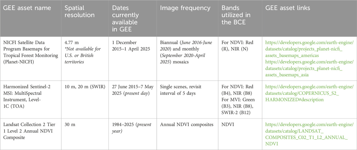
Table 1. Description of GEE satellite imagery products in the Blue Carbon Explorer (BCE).
The BCE also analyzes the Mangrove Vegetation Index (MVI) defined as |NIR–Green|/|SWIR–Green| and is used to estimate changes in the footprint of mangroves, utilizing the Sentinel-2 short-wave infrared (SWIR) band (Baloloy et al., 2020).
Each satellite imagery source is only available in the BCE for the years in which it has full temporal coverage. For example, Planet-NICFI data are available in GEE starting 1 December 2015, but only available in the BCE starting 2016 because a robust annual mosaic cannot be generated using only one monthly mosaic. For this reason, Planet-NICFI is currently available (as of May 2025) in the BCE for 2016–2024, Sentinel-2 for 2016–2024, and Landsat composites for 1984–2024. The variety of satellites available enables users to analyze changes at different temporal and spatial scales. Planet-NICFI data provides the highest spatial resolution (4.77 m), while Sentinel-2 (10 m) can be used in areas not covered by Planet-NICFI, such as U.S. or British territories (e.g., Puerto Rico, U.S. and British Virgin Islands). Sentinel-2 also provides the added functionality of using SWIR (20 m) to analyze MVI for changes in mangrove extent. Finally, Landsat composites, at a lower spatial resolution (30 m), can be used for analyzing long-term habitat trends over 40 years1.
Local-level mangrove footprints are utilized within the BCE for geographies where they are available. PlanetScope-derived mangrove layers are used for The Bahamas (The Nature Conservancy, 2023), Jamaica (The Nature Conservancy, 2025), and Bajo Yuna in the Dominican Republic (The Nature Conservancy, 2023); these 4 m-resolution mangrove extents were derived from a 2017–2019 mosaic of thousands of PlanetScope satellite scenes (Schill et al., 2021), coupled with extensive field validation and local expertise collected during 2022–2024. A national-level mangrove dataset is also used for Trinidad and Tobago (Institute of Marine Affairs, 2023). Mangrove data from the ‘Estuarine Forested Wetland’ class in the Coastal Change Analysis Program (C-CAP) is used for Puerto Rico (National Oceanic and Atmospheric Administration, 2010) and USVI (National Oceanic and Atmospheric Administration, 2012). For the rest of the Insular Caribbean, a manually digitized regional mangrove dataset from high resolution satellite imagery is used (The Nature Conservancy, 2021). For all other geographies, mangrove extents are sourced from Global Mangrove Watch (version 3, 2020 vector) (Bunting et al., 2023).
To demonstrate the detection of mangrove change using the BCE, case studies are presented for Grenada, Jamaica, the Dominican Republic, and The Bahamas. These studies have been validated with field data and local knowledge. In The Bahamas, where highly detailed canopy height data was available, the BCE was also used to inform a mangrove restoration plan on Grand Bahama and Abaco to support habitat recovery following Hurricane Dorian.
2.2 Levera Pond, Grenada
Located at the northern end of the main island, Levera Pond is one of the largest mangrove areas in Grenada. This area was designated a Ramsar protected wetland in 2012 (SDG Knowledge Hub, 2012), and the Levera beaches are one of the most important nesting areas for several sea turtle species. There have been many attempts to develop this area over the years; the latest resulting in direct removal of fringing mangroves and other coastal vegetation to make way for a resort and golf course development (Friends of the Earth Grenada, 2021). The removal of the vegetation is likely to have long-term environmental impacts due to an increase in runoff and sedimentation. Additionally, mangroves in this area and across the country were heavily damaged by Hurricane Beryl which made landfall on 1 July 2024 (Beven et al., 2025). Damages to the Levera Ramsar site were described as 15% uprooted and fallen trees, and 50% defoliated and broken (UNDP, 2024).
The BCE was used to analyze changes in NDVI in Levera Pond between a selected date range of 2016–2024 using Planet-NICFI mosaics. The BCE computed a new ‘NDVI’ band for each Planet-NICFI mosaic (NICFI Data Program, 2024) for the 2016–2024 range (61 mosaics). The average NDVI values, filtered to the bounds of the mangrove extent within the user-drawn area of interest (AOI), were then charted in the NDVI time-series. A quality mosaic function was applied by the BCE for the user-selected start year and end year utilizing the new NDVI band, to generate two annual “greenest pixel composites” for 2016 and 2024. In these greenest pixel composites, each pixel stores the highest NDVI value for that year, to reduce impacts of seasonal NDVI changes on the change analysis results. The 2016 greenest pixel composite is then subtracted from the 2024 greenest pixel composite, masked to the mangrove polygon extent, and displayed on the map to show change in NDVI values during the selected range of years (Figure 1). Areas of NDVI loss indicate mangrove degradation, and areas of NDVI gain indicate mangrove biomass gain or growth (Aljahdali et al., 2021; Lee et al., 2021; Wei et al., 2025). Further, the ‘area of loss/gain’ was calculated using an NDVI change threshold of 0.1 to understand the percentage of total mangrove area impacted by development.
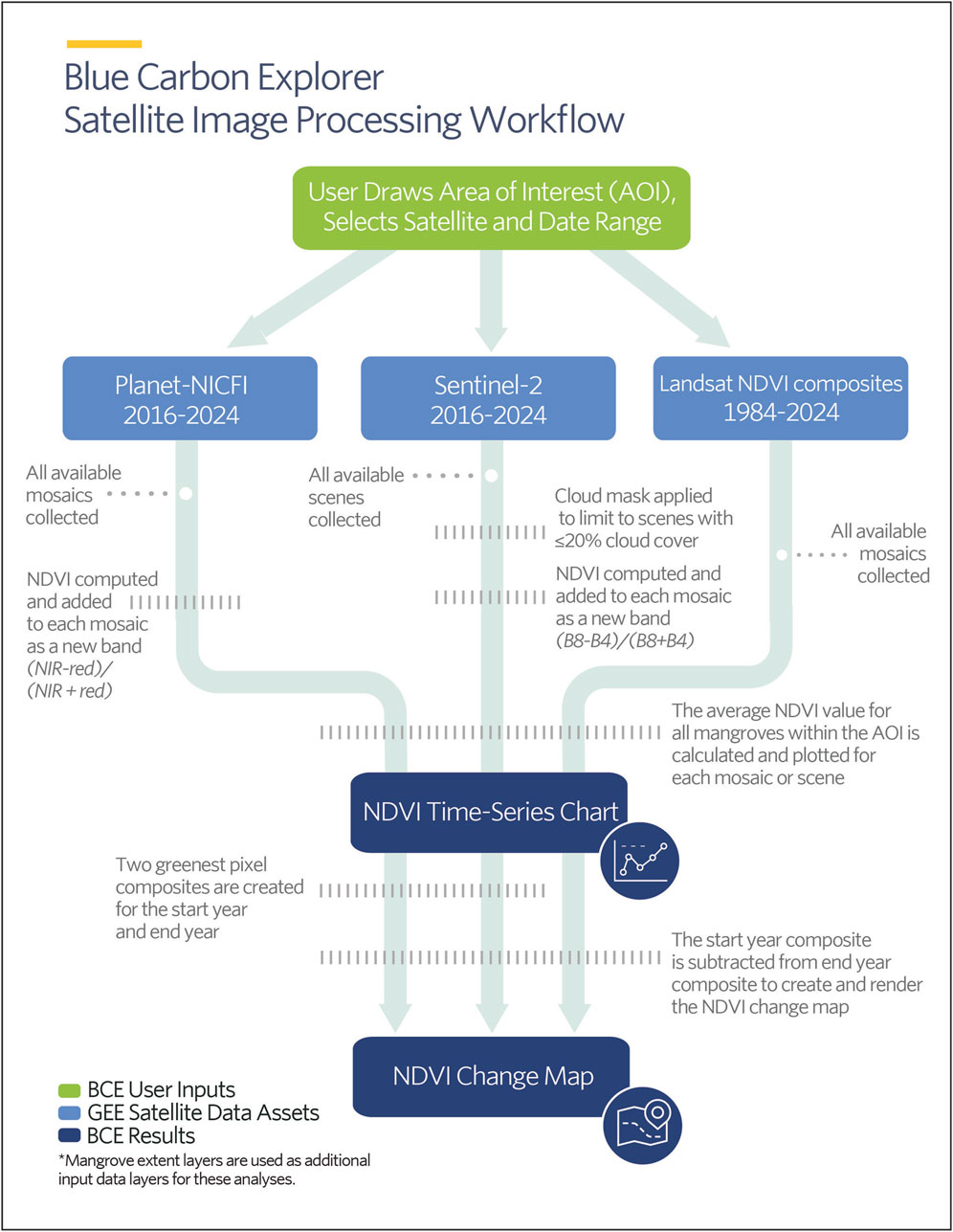
Figure 1. Diagram of the BCE’s satellite image processing workflow for mapping and charting NDVI changes.
Drone imagery was collected at this site on 1 March 2025 to qualitatively validate mangrove habitat loss through visual inspection, which was used for comparison with the BCE change detection results. It is important to follow and obey local regulations and laws when conducting drone operations for monitoring mangroves.
2.3 Salt River, Jamaica
In Salt River, Jamaica, mangroves have faced significant die-off and habitat loss, due to a combination of natural and human-induced factors. These include the impacts of Hurricane Ivan in 2004, the construction of a train line that disrupted tidal flow, the closure of a sugar company that eliminated a major freshwater source, and the development of a causeway without culverts that altered the hydrology of the ecosystem (Murphy, 2023; UWI SODECO, 2022; Schill et al., 2024). Additionally, human activities like mangrove removal for charcoal, oyster harvesting, agricultural expansion, and infrastructure development have further contributed to the decline.
The BCE was used to analyze changes in NDVI between a selected date range of 2016–2024 using both Planet-NICFI mosaics and Sentinel-2 scenes. The BCE computed NDVI changes using the Planet-NICFI mosaics following the same workflow as the Grenada site. For Sentinel-2 images, a cloud mask was applied to Sentinel-2 images so that only images with less than 20% cloud cover were utilized. Band math was used to create a new ‘NDVI’ band. Average mangrove NDVI values within the AOI were plotted in the time-series chart for each image (3,475 scenes for this AOI). Similarly to the Planet-NICFI data, the Sentinel-2 images were mosaiced into two annual greenest pixel composites for 2016 and 2024, using the quality mosaic function on the new NDVI band. The 2016 NDVI mosaic was subtracted from the 2024 NDVI mosaic to display NDVI change on the map.
Additionally, longer-term mangrove trends over a 40-year timespan (1984–2024) were analyzed using the Landsat Collection 2 Tier 1 Level 2 NDVI composites. These pre-processed annual NDVI composites are developed and served in GEE by the U.S. Geological Survey. The BCE again plotted the NDVI time-series within the selected mangroves for each annual mosaic (41 mosaics), computed the difference in NDVI values between the 1984 mosaic and the 2024 mosaic, and displayed the NDVI change layer for 1984–2024 on the map. The BCE processing workflow for NDVI analysis using each satellite imagery product is visualized in Figure 1, and the corresponding number of images utilized for these analyses in Salt River is described in Table 2.
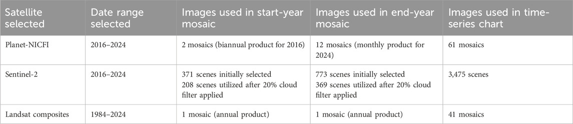
Table 2. Number of images utilized by the BCE for each NDVI satellite analysis for the case study area in Salt River, Jamaica.
Drone imagery was collected at this site in February 2019 to document mangrove extent and condition, which was used for comparison with the BCE change detection results.
2.4 Parque Nacional Manglares Del Bajo Yuna, Dominican Republic
In Parque Nacional Manglares Del Bajo Yuna in the Dominican Republic, mangroves are expanding out into Samaná Bay due to sedimentation at the mouth of the Yuna and Barracote rivers. The BCE was used to compute NDVI and evaluate mangrove change using the Planet-NICFI mosaics for 2016–2024, following the same data processing workflow as the Grenada and Jamaica sites. Additionally, changes in the mangrove footprint were evaluated in the BCE using Sentinel-2 images to compute MVI for 2016 and 2024. A cloud mask was again applied to Sentinel-2 images to only utilize images with 20% cloud cover or less. Band math was applied to create a new ‘MVI’ band (Baloloy et al., 2020). MVI can only be computed within the BCE using Sentinel-2 imagery, due to the availability of the SWIR band. MVI is computed for each cloud-masked Sentinel-2 image. The images were mosaiced into two annual MVI composites for 2016 and 2024, using the quality mosaic function on the new MVI band. The MVI 2016 and 2024 mosaics were each displayed on the map using checkboxes for visual inspection of changes in mangrove extent over time. Drone imagery was collected at this site in December 2017 and August 2022 to evaluate changes in mangrove extent within the national park, which was used for comparison with these BCE change detection results.
2.5 Grand Bahama and Abaco, The Bahamas
On the northern Bahamian islands of Grand Bahama and Abaco, mangrove habitats were devastated during Hurricane Dorian in 2019. Damage to mangroves from this storm exceeded more than 73% (9,117 ha) in Grand Bahama and 40% (8,773 ha) in Abaco (Bahamas National Trust, 2021; McKenzie et al., 2023). An NDVI change analysis was run in the BCE using Planet-NICFI data for 2016–2024 to map the habitat damage and align the drop-off in NDVI temporally with Hurricane Dorian’s landfall on Grand Bahama on 2 September 2019 as the primary driver of degradation. Field data (GoPro photos) collected on Grand Bahama in September 2022 was used to validate habitat damage.
To guide the identification of restoration areas in need of human intervention, local ecological expertise suggested that: 1) damaged mangroves farther away from taller, healthy mangroves (which produced more propagules as seed sources, Figure 2B) would take longer to naturally recover; and 2) that damaged areas previously hosting tall mangroves may provide suitable environmental conditions for mangrove growth. Restoring these once healthy areas could enhance natural recovery by reestablishing additional seed sources.
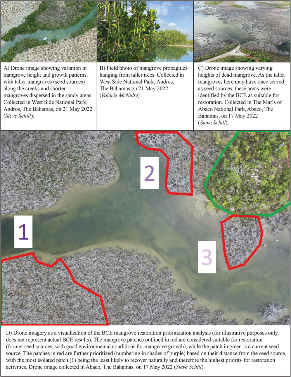
Figure 2. Illustration of the BCE’s mangrove restoration prioritization analysis (D), as illustrated using recent drone imagery (A,C) and field photos (B) collected in The Bahamas.
Multiple canopy height datasets are available in the BCE for visualization; TerraSAR-X add-on for Digital Elevation Measurement (TanDEM-X) x-band radar data (12-m resolution, 2015) from Simard et al. (2025) and Simard et al. (2024) are available for The Bahamas and Jamaica within the footprint of mangrove extent, and Global Ecosystem Dynamics Investigation (GEDI) lidar data from Potapov et al. (2021) are available for mangroves in all other geographies. Additional functionality is possible utilizing the TanDEM-X canopy height data to identify priority mangroves for restoration. It is important to note that Simard et al. (2025) report a vertical accuracy of 2.4 m (RMSE) when using the TanDEM-X data and suggest calibrating and validating canopy measurements independently in the field or using GEDI mission data or airborne lidar.
A prioritization analysis was run in the BCE to overlay NDVI changes with canopy height to identify suitable sites for mangrove restoration that are not likely to recover naturally. The BCE was used to first analyze NDVI change over time to identify the mangrove areas that had not recovered (as indicated by a reduced level of photosynthesis) and areas that had (as indicated by an increased level of photosynthesis), using a threshold of 0.1 NDVI gain to identify ‘healthy mangroves’ and −0.1 NDVI loss to identify ‘degraded mangroves’. Both healthy and degraded mangroves were further filtered using a canopy height threshold of 6 ft (1.8 m) to identify ‘tall’ mangroves. The tall, degraded areas (Figure 2C) were then prioritized for restoration based on their level of isolation from tall, healthy mangroves (Figure 2A) – the farther from a seed source, the higher priority to restore (Figure 2D). This analysis, coupled with field validation and local knowledge, was used to draft an initial mangrove restoration plan for the islands of Grand Bahama and Abaco.
3 Results
3.1 Levera Pond, Grenada
At Levera Pond, the Planet-NICFI NDVI analysis found that of the total mangrove patch (44 ha), 9% (4 ha) experienced degradation during 2016–2024 (≤-0.1 NDVI change). The NDVI values of the mangroves within this AOI drop from an average 0.834 in April 2024 to 0.613 in August 2024, shortly after Hurricane Beryl (July 2024). The value further declines to 0.558 for November 2024, which may indicate delayed or ongoing reaction to the hurricane impacts with the continuing decline in biomass. Longer-term, it was observed that the Levera Pond mangrove patch’s average NDVI value hovered around 0.8 for several years (2016–2022) with a steady decline to the low value of 0.558 in November 2024. This indicates that degradation may be caused by multiple stressors in addition to Hurricane Beryl, including clear-cutting and hydrological alteration or water quality impacts related to development. This degradation can be seen (areas in red) on the 2016–2024 NDVI change analysis map (Figure 3A). This habitat loss was verified using the underlying 2025 Google satellite image mosaic, showing the area that has been clear-cut for development (Figure 3B), and using drone imagery collected on 1 March 2025 (Figure 3C).
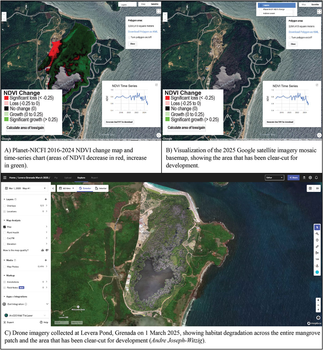
Figure 3. BCE NDVI change analysis (A) and field validation (B,C) of mangrove degradation at Levera Pond, Grenada, caused by the impacts of Hurricane Beryl and long-term development.
3.2 Salt River, Jamaica
The BCE NDVI change maps show extensive degradation across the mangroves in Salt River using all three satellite imagery products (Figure 4A: Planet-NICFI; Figure 4B: Sentinel-2; Figure 4C: Landsat composites). This habitat loss was verified using drone imagery collected in February 2019 (Figure 4D), which shows a stark change in mangrove health on either side of the train line.
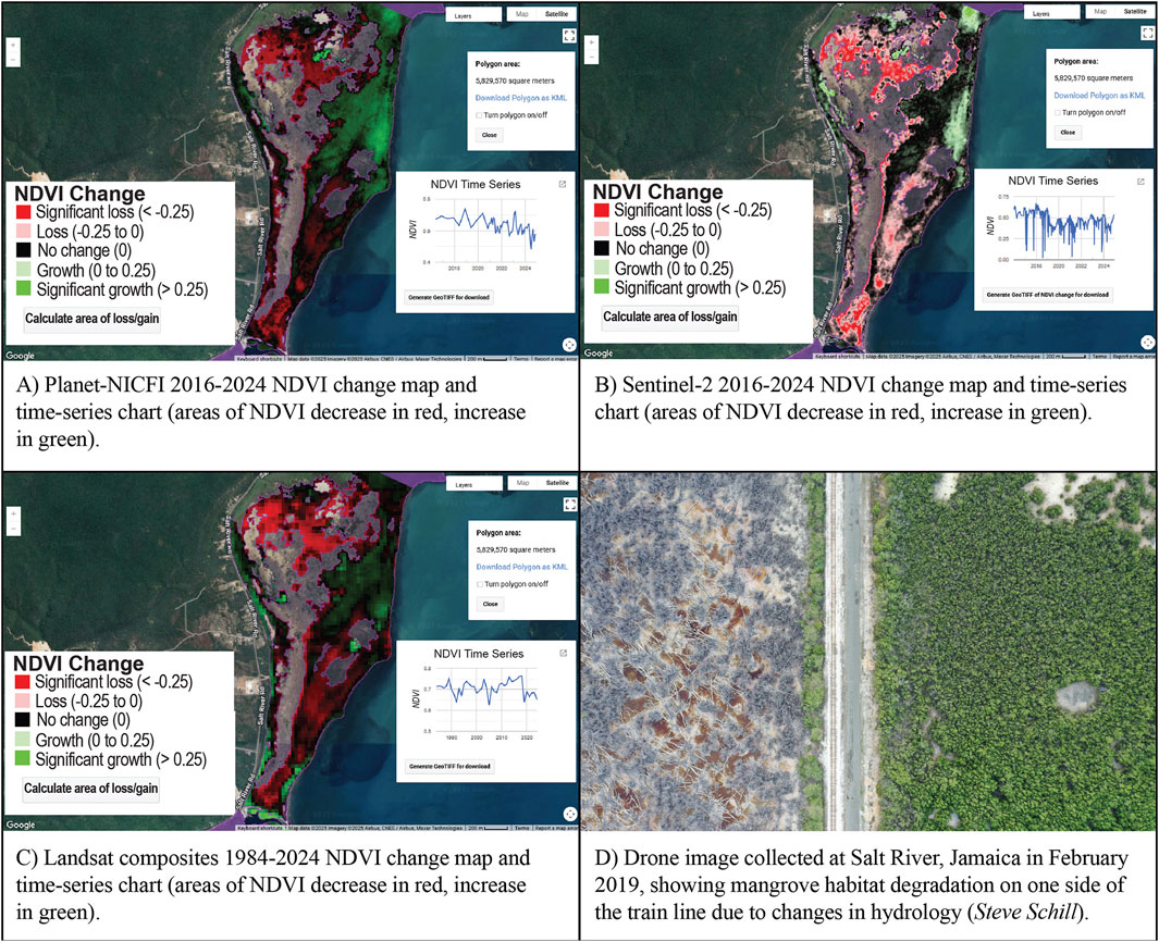
Figure 4. BCE NDVI change analysis (A-C) and field validation (D) of mangrove degradation in Salt River, Jamaica, caused by the impacts of development and multiple hurricanes.
The Planet-NICFI time-series shows a general steady decline in NDVI from a value of 0.694 in December 2016 to 0.566 in December 2024 (Figure 5A). A steep drop in NDVI occurred between May 2024 (0.632) and July 2024 (0.478). This may be due to Hurricane Beryl, which made landfall in Jamaica on 3 July 2024 as a Category 4 hurricane, causing extensive damage in the parish of Clarendon (IFRC, 2024). The Sentinel-2 time-series is noisy due to the number of scenes analyzed (3,475 scenes) but also shows a general steady decline in NDVI from 0.645 in February 2016 to 0.424 in August 2024 (Figure 5B). Finally, Landsat composites showed a long-term NDVI decline in this mangrove patch over the last 40 years, from an average annual value of 0.712 in 1984 to 0.643 in 2024 (Figure 5C). Three notable drops are visible on the chart, during 1989–1992, 2003–2005, and 2018–2019. Further investigation is needed to determine if these dates align with specific drivers of degradation, such as development activities or destructive natural events.

Figure 5. BCE NDVI change analysis time-series charts (A-C) for the Salt River, Jamaica study area, utilizing the maximum date range available for each satellite imagery product.
3.3 Parque Nacional Manglares Del Bajo Yuna, Dominican Republic
The expansion of mangroves into Samaná Bay within Bajo Yuna National Park can be seen on the 2016–2024 Planet-NICFI NDVI change results (Figure 6A) and by comparing the Sentinel-2 MVI maps for 2016 and 2024 (Figure 6B). Drone images collected in December 2017 (Figure 6C) and August 2022 (Figure 6D) confirm this expansion.
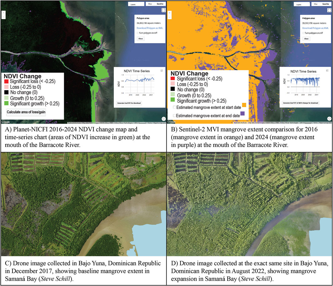
Figure 6. BCE NDVI change analysis (A) and MVI mangrove extent comparison (B), alongside field validation of mangrove expansion into Samaná Bay, Dominican Republic, due to sedimentation buildup at the mouth of the river (C,D).
3.4 Grand Bahama and Abaco, The Bahamas
The Planet-NICFI NDVI change map highlights the widespread mangrove degradation caused by Hurricane Dorian in Northshore the Gap National Park, on the north coast of Grand Bahama (Figure 7A). The corresponding time-series chart shows much of this loss occurred between June (0.37) and December 2019 (0.275), corresponding with the hurricane’s landfall on Grand Bahama on 2 September 2019 (Figure 7B). Though it was apparent through local knowledge that much of the mangrove degradation was caused by hurricane impacts, this highlights the utility of the BCE’s NDVI time-series function for identifying drivers of degradation that may be less clear in other areas. Field photos collected in September 2022 (Figure 7C) confirm this widespread habitat loss.
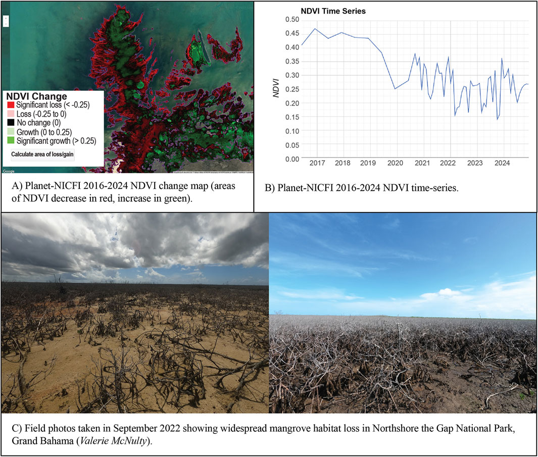
Figure 7. BCE Planet-NICFI 2016–2024 NDVI change map (A) and time-series (B), alongside field validation of mangrove loss in Northshore the Gap National Park on Grand Bahama, due to impacts of Hurricane Dorian (C).
The prioritization analysis, combining the NDVI change results with canopy height information, highlighted suitable restoration sites (Figure 8, areas in orange) and possible mangrove seed sources (Figure 8, areas in teal) in the BCE window.
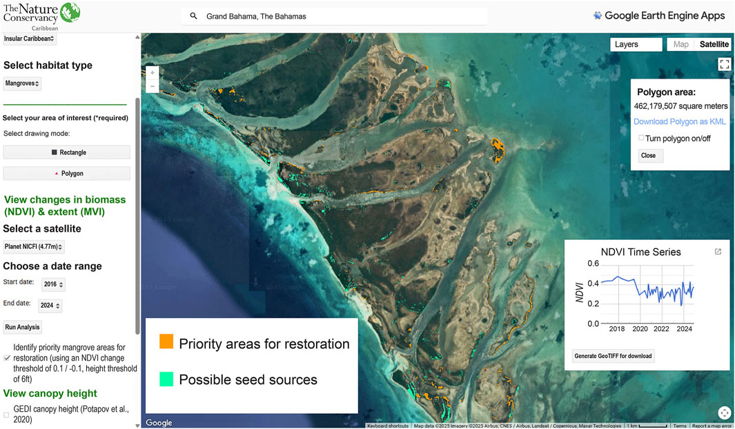
Figure 8. Blue Carbon Explorer results highlight suitable areas for restoration (orange) and potential seed sources (green) in East Grand Bahama National Park.
After downloading these results from the BCE, the suitable restoration sites were prioritized using the ‘Near’ tool in GEE, based on their distance from potential seed sources, where more isolated sites (in darker purples, Figure 9) are less likely to recover naturally and therefore higher priority for restoration interventions.
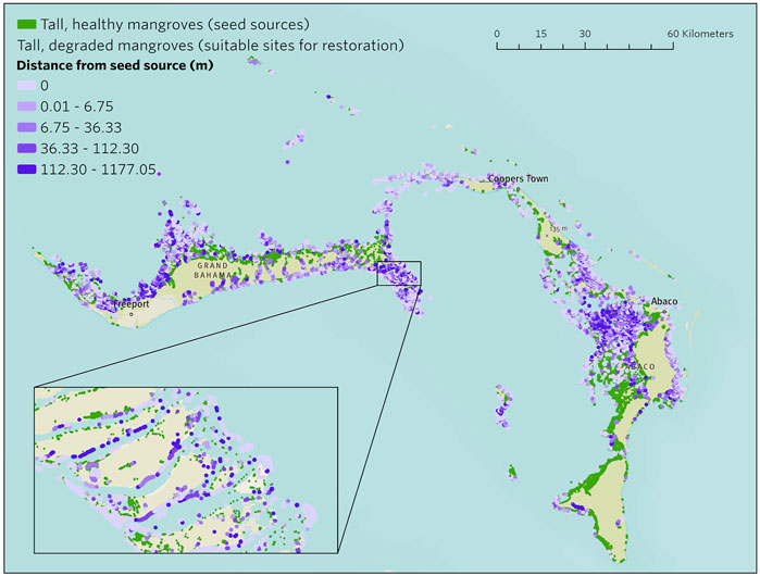
Figure 9. Prioritization of mangroves for restoration based on distance from a possible seed source (darker purple areas are less likely to recover naturally and therefore higher priority to restore), based on NDVI and canopy height analysis results exported from the Blue Carbon Explorer.
Combining these results with local knowledge and overlaying sites of existing mangrove restoration efforts on Grand Bahama and Abaco, a mangrove restoration plan was developed for Grand Bahama and Abaco (Figure 10). Field measurements and carbon sampling were completed in these areas on Grand Bahama and Abaco as a baseline analysis of carbon stocks of these habitats that can be monitored over time as restoration efforts progress.
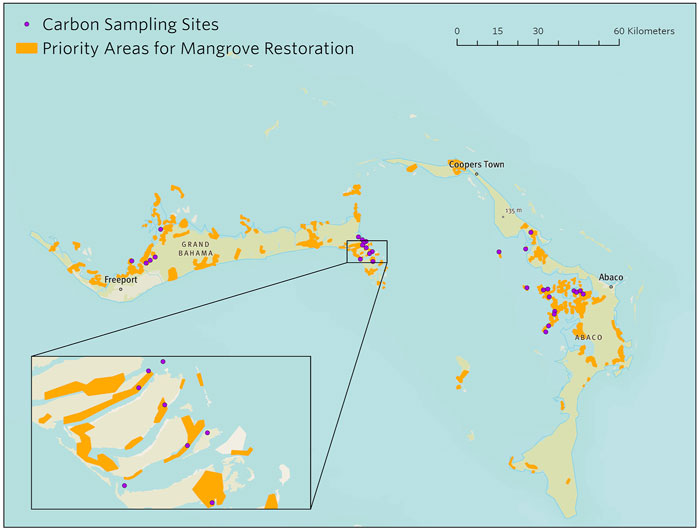
Figure 10. Carbon sampling sites overlaid with the mangrove restoration plan drafted in 2022 based on the Blue Carbon Explorer prioritization results.
4 Discussion
The BCE provides conservation practitioners and government decision-makers with the ability to analyze changes in mangrove condition (via NDVI) across space and time, allowing users to better identify drivers of habitat degradation and calculate area of impact. The Planet-NICFI, Sentinel-2, and Landsat composites complement each other, providing a range of spatial and temporal resolutions and coverage across all mangrove-relevant geographies. Inspecting MVI using Sentinel-2 further enables monitoring of changes in extent like expansion or deforestation. Finally, suitable mangrove areas for restoration can be identified and prioritized by combining NDVI change with canopy height to map mangrove areas unlikely to naturally recover. The BCE enhances the ability of conservation practitioners to monitor mangrove health and to use a scientifically driven process to inform restoration planning. Harnessing the power of GEE, the BCE’s user-driven analysis capabilities can be applied to a specific area of interest without requiring extensive technical skills, software licensing, or computing power. The results can be exported from GEE for additional GIS analyses offline when desired.
4.1 Applications for habitat monitoring and nationally determined contributions (NDCs)
The BCE can support countries with establishing targets and monitoring and reporting initiatives related to climate mitigation. In recent years, the NDC Partnership has received an increased demand from country members requesting technical assistance to address blue carbon and ocean-related needs within their Nationally Determined Contribution (NDC Partnership, 2023). The Alliance of Small Island States (of which several Caribbean countries are part) represented more than half of the requests received. The majority of commitments related to coastal wetlands are presently included in the adaptation portion of the NDCs (as enhanced management and protection) and not expressed in terms of quantitative emissions reduction or mitigation goals (NDC Partnership, 2023); this is likely related to an overall limited capacity to estimate and measure emissions of blue carbon ecosystems. Coastal wetland restoration plans and targets included in the NDCs require research efforts and capacities for habitat mapping and stock assessments; the BCE can help countries with quantifying habitat baselines, establishing gaps, and facilitating monitoring. In addition to national governments, there are numerous local and regional conservation entities in the region with limited capacity for monitoring and access to information platforms or remote imagery, such as Marine Protected Area (MPA) managers. The BCE facilitates access for diverse users in conservation planning and monitoring to remote sensing technology, helping prioritize areas for fieldwork, thus reducing costs. This enables local organizations to focus more resources on conservation efforts rather than assessments. Through a series of case studies across the Caribbean, we demonstrate that the BCE is a powerful tool for conservation planning, with implications for MPA expansion, habitat threat abatement, and mangrove restoration planning, and the potential to enhance efforts on climate adaptation, mitigation, and biodiversity.
In Grenada, the 2024 UNDP post-hurricane damage assessment focused on documenting the hurricane’s impact on many of the main mangrove sites around the country. However, certain large areas of mangrove on mainland Grenada were not included in the assessment. These include large and varied mangrove ecosystems located in the Great River Bay and Conference Bay areas on the north-eastern side of the mainland, in the parish of St. Andrews which were also impacted by Hurricane Beryl. Some of these areas have been sites where mangrove restoration activities have taken place before (Welsh, 2025). Use of the BCE tool can help to fill some of these gaps by monitoring areas where in-situ damage assessments have not taken place. The 2024 UNDP assessment also did not place a monetary value on the damage caused to the mangrove ecosystems in Grenada or ascribe estimated costs related to restoration needs; ecosystem services models could be combined with BCE analyses to understand and value the protective services that mangroves provide to people and infrastructure. Recently, the SoilCare Project has produced an updated national soil organic sequestration map for Grenada (Now Grenada, 2025); though this is focused on agricultural soils, field data collection capacities could be leveraged for mangrove sites to collect data needed for analyzing the potential for blue carbon sequestration. Further, fieldwork is underway in Grenada through the regional Caribbean Carbon Accounting in Seagrass (CariCAS) initiative to quantify the blue carbon potential of seagrass ecosystems (FIU Seagrass Ecosystems Research Lab, 2024).
The Government of Jamaica considers mangroves a crucial national resource; though often citing a paucity of data on natural ecosystems as a deterrent to making informed policy and management decisions, the government has taken additional steps for their conservation and restoration. In 2023, the Forestry Department prepared the National Mangrove and Swamp Forest Management Plan (NMSFMP) proposing actions and interventions to conserve and protect the country’s remaining forested wetlands. Collaborative efforts between the government, The University of the West Indies-Mona Centre for Marine Sciences, The Nature Conservancy, and other stakeholders were completed in 2024 to develop a national inventory of seagrass beds and to refine and improve the accuracy of existing mangrove maps, revealing 11,978 ha of mangrove and 55,678 ha of seagrass (The Nature Conservancy, 2025); the resulting maps have been integrated into the BCE as a first critical first step to informing its potential in future national mitigation strategies. The Forestry Department of Jamaica intends to utilize these updated habitat maps in the BCE to guide the identification of potential sites for restoration and/or conservation coupled with the implementation of the actions and strategies articulated in the NMSFMP. These maps have advanced the understanding of the carbon sequestration role of coastal blue carbon ecosystems. Based on work done by the Centre for Marine Sciences of the University of the West Indies-Mona, the mangrove forests and seagrass beds have preliminary carbon stock estimates of 4,699,894 ± 232,566 MgC and 7,326,538.10 ± 1,915,206.24 MgC, respectively (UWI Mona Centre for Marine Sciences, 2025). Armed with this knowledge, Jamaica can now include these blue carbon ecosystems into national climate policies, greenhouse gas inventories, and their NDC, and explore opportunities for the carbon market to unlock critical financial resources. Inclusion of blue carbon into policies and market initiatives serves to further prioritize their health and resilience, increasing the adaptive capacity of the country to respond to and keep pace with climate change impacts.
The Bahamas’ NDC (V2) included mangroves as part of its adaptation actions, under “Enhance protection and restoration of damaged/degraded ecosystems”. The mitigation co-benefit of this action is also mentioned. Use of the BCE has allowed local conservation organizations, Bahamas Mangrove Alliance (BMA) and partners, through the Northern Bahamas Mangrove Restoration Project (NBMR), to incorporate data-driven prioritization into site selection and restoration design. Use of quantitative, geospatial data in the NBMR project has helped to overcome difficulties in accessing remote areas and lack of field-measured data. The BMA intends to scale-up restoration efforts significantly to meet conservation goals, with a 3-year goal of 1 million mangroves planted towards restoring 10,000 ha of degraded areas on Grand Bahama and Abaco. To date the project has restored 140 ha, planting more than 300,000 mangroves across both islands (Bahamas Mangrove Alliance, 2025). Innovative restoration techniques are needed to achieve restoration at this scale; the BMA is currently studying success rates of direct outplanting (more manual labor) vs. wave dispersal (scale up) and evaluating the potential of using drones for dropping propagules in hard-to-reach areas.
4.2 Applications for climate finance
The BCE’s practical implications extend beyond tracking mangrove habitat trends for management activities; it can also play a role in accessing climate finance. Small Island States hold almost 2,900 Tg of blue carbon, but only 23% have quantitative blue carbon targets (Friess, 2023). Though demand for blue carbon credits is on the rise, and protection of 20% of the world’s mangrove forests could be funded through carbon financing (Zeng et al., 2021), only nine blue carbon credit projects have currently been verified, none of which fall in the Insular Caribbean (Friess et al., 2022). A fundamental step in scoping climate finance opportunities is understanding the need, scale, and potential for restoration or enhanced protection interventions (Macreadie et al., 2022). Developing climate finance projects, such as those aimed at generating blue carbon offsets, requires scaling potential to ensure financial feasibility. Given that on-the-ground mangrove habitat assessments can be labor-intensive, access to up-to-date satellite imagery can enhance efficiencies in field validation and monitoring efforts. In addition, the tool aids in comprehending drivers of change. For instance, highlighting areas of trending loss provides an opportunity to align with temporal and local context regarding the cause of loss, ultimately informing actions to reverse or halt these losses. Practitioners can identify areas in need of management intervention and assess whether project activities are expected to generate net climate benefits–criteria essential for determining carbon market project fit.
5 Conclusion
The BCE supports restoration and conservation project design, the core element for potential blue carbon market projects. It has widespread applications for mangrove habitat monitoring, threat abatement and conservation actions, and ultimately climate mitigation goals such as the NDCs. However, despite its name, it does not currently quantify blue carbon storage. Quantifying blue carbon storage potential (spatially or numerically) for mangroves and seagrass is made difficult by lack of above ground (tree diameter and height) and below ground (soil carbon) field measurements in relevant geographies. This critical data gap is being addressed by efforts through partnerships between conservation organizations and local governments across the Caribbean to collect field data to facilitate carbon mapping of both mangroves and seagrass. Currently, seagrass maps (4 m-resolution) can be visualized in the BCE for the Insular Caribbean (Schill et al., 2021), but functionality is not yet built out for tracking change in seagrass habitats. Analyzing change in seagrass is more complex than monitoring terrestrial habitats due to the influence of the water column. The BCE team is committed to improving the tool over time; these limitations have been identified for future research and enhancement of the tool. As more case studies and applications are developed by users, further improvements to the design can be identified and implemented.
Data availability statement
The Blue Carbon Explorer can be found at https://BlueCarbon.tnc.org. Corresponding data layers can be downloaded from the data library at https://CaribbeanScienceAtlas.tnc.org.
Author contributions
VM: Data curation, Methodology, Project administration, Validation, Visualization, Conceptualization, Writing – original draft, Formal Analysis, Software, Investigation, Writing – review and editing. DP: Writing – review and editing, Methodology, Writing – original draft, Conceptualization, Validation, Data curation. SfS: Writing – original draft, Conceptualization, Project administration, Writing – review and editing. JB: Project administration, Writing – original draft, Writing – review and editing, Conceptualization. AJ-W: Writing – original draft, Resources, Conceptualization, Writing – review and editing, Validation. LJ: Project administration, Writing – review and editing, Conceptualization, Writing – original draft, Funding acquisition. LS: Writing – original draft, Writing – review and editing, Conceptualization. RM: Conceptualization, Writing – review and editing, Writing – original draft, Project administration. SG: Project administration, Writing – original draft, Data curation, Writing – review and editing, Conceptualization. MM: Funding acquisition, Writing – review and editing, Writing – original draft, Conceptualization, Project administration, Supervision. CC: Writing – review and editing, Conceptualization, Writing – original draft. SvS: Data curation, Project administration, Validation, Conceptualization, Methodology, Writing – review and editing, Supervision, Resources, Writing – original draft, Investigation, Funding acquisition.
Funding
The author(s) declare that financial support was received for the research and/or publication of this article. The research in The Bahamas and the development of the Blue Carbon Explorer was supported by the Food and Agriculture Organization (FAO) of the United Nations, the Global Fund for Coral Reefs (GFCR), Builders Initiative, COmON Foundation, Paul M. Angell Family Foundation, and the Ocean Risk and Resilience Action Alliance (ORRAA). The research in Jamaica was supported by The Pew Charitable Trusts grant ID 37143 to The Nature Conservancy and grant ID 37062 to The University of West Indies.
Acknowledgments
We would like to acknowledge the support of several key partners, including The Nature Conservancy (TNC), Planet Labs, the Food and Agriculture Organization (FAO) of the United Nations, the Bahamas Mangrove Alliance (BMA), the University of the West Indies (UWI) – Mona Centre for Marine Sciences, Pew Charitable Trusts, Global Mangrove Watch (GMW), National Aeronautics and Space Administration (NASA), National Oceanic and Atmospheric Administration (NOAA), Institute of Marine Affairs (IMA), and Google Earth Engine (GEE).
Conflict of interest
Author RM was employed by TerraCarbon LLC.
The remaining authors declare that the research was conducted in the absence of any commercial or financial relationships that could be construed as a potential conflict of interest.
Generative AI statement
The author(s) declare that no Generative AI was used in the creation of this manuscript.
Any alternative text (alt text) provided alongside figures in this article has been generated by Frontiers with the support of artificial intelligence and reasonable efforts have been made to ensure accuracy, including review by the authors wherever possible. If you identify any issues, please contact us.
Publisher’s note
All claims expressed in this article are solely those of the authors and do not necessarily represent those of their affiliated organizations, or those of the publisher, the editors and the reviewers. Any product that may be evaluated in this article, or claim that may be made by its manufacturer, is not guaranteed or endorsed by the publisher.
Footnotes
1Planet-NICFI will no longer be accessible in GEE starting 1 April 2025. This is because the current phase of NICFI’s program to provide high-resolution Planet imagery for free, through partnership with Planet and Kongsberg Satellite Services (KSAT), has ended. NICFI is currently developing a new phase of the Satellite Data Program, to be launched in 2025. However, Planet-NICFI data is still available in the BCE as of May 2025.
References
Ali, A., and Nayyar, Z. A. (2020). Extraction of mangrove forest through Landsat 8 mangrove index (L8MI). Arabian J. Geosciences 13, 1132–12. doi:10.1007/s12517-020-06138-4
Aljahdali, M. O., Munawar, S., and Khan, W. R. (2021). Monitoring mangrove forest degradation and regeneration: Landsat time series analysis of moisture and vegetation indices at Rabigh Lagoon, Red Sea. Forests 12 (1), 52. doi:10.3390/f12010052
Asari, N., Suratman, M. N., Mohd Ayob, N. A., and Abdul Hamid, N. H. (2021). “Mangrove as a natural barrier to environmental risks and coastal protection,” Biodiversity and Management, 305–322. doi:10.1007/978-981-16-2494-0_13
Bahamas Mangrove Alliance (2025). Bahamas mangrove alliance dashboard. Available online at: https://www.bahamasmangrovealliance.org/dashboard/(Accessed May 12, 2025).
Bahamas National Trust (2021). State of the environment: post hurricane dorian report. Available online at: https://bnt.bs/storage/2021/12/State-of-the-Environment-Post-Dorian-Report-2021-1.pdf.
Baloloy, A. B., Blanco, A. C., Ana, R. R. C. S., and Nadaoka, K. (2020). Development and application of a new mangrove vegetation index (MVI) for rapid and accurate mangrove mapping. ISPRS J. Photogrammetry Remote Sens. 166, 95–117. doi:10.1016/j.isprsjprs.2020.06.001
Beven, J. L., Fritz, C., and Alaka, L. (2025). National hurricane center tropical cyclone report. Hurric. Beryl (AL022024), 1–76. Available online at: https://www.nhc.noaa.gov/data/tcr/AL022024_Beryl.pdf.
Bunting, P., Hilarides, L., Rosenqvist, A., Lucas, R. M., Kuto, E., Gueye, Y., et al. (2023). Global mangrove watch: monthly alerts of mangrove loss for Africa. Remote Sens. 15 (8), 2050. doi:10.3390/rs15082050
Campbell, C. (2018). “Topographical data: unprecedented insight into Grenada’s terrestrial and coastal landscapes,” in NOW Grenada. Available online at: https://nowgrenada.com/2018/06/topographical-data-unprecedented-insight-into-grenadas-terrestrial-and-coastal-landscapes/.
Choudhary, B., Dhar, V., and Pawase, A. S. (2024). Blue carbon and the role of mangroves in carbon sequestration: its mechanisms, estimation, human impacts and conservation strategies for economic incentives. J. Sea Res. 199, 102504. doi:10.1016/j.seares.2024.102504
Contessa, V., Dyson, K., Vivar Mulas, P. P., Kindgard, A., Liu, T., Saah, D., et al. (2023). Uncovering dynamics of global mangrove gains and losses. Remote Sens. 15 (15), 3872. doi:10.3390/rs15153872
Crawford, C. J., Roy, D. P., Arab, S., Barnes, C., Vermote, E., Hulley, G., et al. (2023). The 50-year Landsat collection 2 archive. Sci. Remote Sens. 8, 100103. doi:10.1016/j.srs.2023.100103
Deering, D. W., and Haas, R. H. (1980). “Using Landsat digital data for estimating green biomass,” in Ann. Meeting of the soc. For range management symp. on Rangeland remote sensing.
Eric, G. (2023). The role of web mapping in spatial data accessibility. Geoinfor Geostat Overv. 11, 3.
FIU Seagrass Ecosystems Research Lab (2024). Caribbean carbon accounting in seagrass. Available online at: https://seagrass.fiu.edu/caricas.htm (Accessed May 28, 2025).
Friends of the Earth Grenada (2021). “Concern with Levera project” in the new today. Available online at: https://www.thenewtodaygrenada.com/letters/concern-with-levera-project/.
Friess, D. A. (2023). The potential for mangrove and seagrass blue carbon in Small Island States. Curr. Opin. Environ. Sustain. 64, 101324. doi:10.1016/j.cosust.2023.101324
Friess, D. A., Howard, J., Huxham, M., Macreadie, P. I., and Ross, F. (2022). Capitalizing on the global financial interest in blue carbon. PLoS Clim. 1 (8), e0000061. doi:10.1371/journal.pclm.0000061
Friess, D. A., Shribman, Z. I., Stankovic, M., Iram, N., Baustian, M. M., and Lewis, C. J. E. (2024). Restoring blue carbon ecosystems. Camb. Prisms Coast. Futur. 2, e9. doi:10.1017/cft.2024.9
Gatt, Y. M., Walton, R. W., Andradi-Brown, D. A., Spalding, M. D., Acosta-Velázquez, J., Adame, M. F., et al. (2024). The Mangrove Restoration Tracker Tool: meeting local practitioner needs and tracking progress toward global targets. One Earth 7 (11), 2072–2085. doi:10.1016/j.oneear.2024.09.004
Goldberg, L., Lagomasino, D., Thomas, N., and Fatoyinbo, T. (2020). Global declines in human-driven mangrove loss. Glob. Change Biol. 26 (10), 5844–5855. doi:10.1111/gcb.15275
Gorelick, N., Hancher, M., Dixon, M., Ilyushchenko, S., Thau, D., and Moore, R. (2017). Google Earth engine: planetary-scale geospatial analysis for everyone. Remote Sens. Environ. 202, 18–27. doi:10.1016/j.rse.2017.06.031
Gupta, K., Mukhopadhyay, A., Giri, S., Chanda, A., Majumdar, S. D., Samanta, S., et al. (2018). An index for discrimination of mangroves from non-mangroves using LANDSAT 8 OLI imagery. MethodsX 5, 1129–1139. doi:10.1016/j.mex.2018.09.011
Hagger, V., Worthington, T. A., Lovelock, C. E., Adame, M. F., Amano, T., Brown, B. M., et al. (2022). Drivers of global mangrove loss and gain in social-ecological systems. Nat. Commun. 13 (1), 6373. doi:10.1038/s41467-022-33962-x
Howard, J., Sutton-Grier, A. E., Smart, L. S., Lopes, C. C., Hamilton, J., Kleypas, J., et al. (2023). Blue carbon pathways for climate mitigation: Known, emerging and unlikely. Mar. Policy 156, 105788. doi:10.1016/j.marpol.2023.105788
IFRC (2024). IFRC initial assessment report - hurricane Beryl: Jamaica. Available online at: https://reliefweb.int/report/jamaica/ifrc-initial-assessment-report-hurricane-beryl-jamaica-19-august-2024.
Lee, C. K., Duncan, C., Nicholson, E., Fatoyinbo, T. E., Lagomasino, D., Thomas, N., et al. (2021). Mapping the extent of mangrove ecosystem degradation by integrating an ecological conceptual model with satellite data. Remote Sens. 13 (11), 2047. doi:10.3390/rs13112047
Lovelock, C. E., Barbier, E., and Duarte, C. M. (2022). Tackling the mangrove restoration challenge. PLoS Biol. 20 (10), e3001836. doi:10.1371/journal.pbio.3001836
Macreadie, P. I., Robertson, A. I., Spinks, B., Adams, M. P., Atchison, J. M., Bell-James, J., et al. (2022). Operationalizing marketable blue carbon. One Earth 5 (5), 485–492. doi:10.1016/j.oneear.2022.04.005
McKenzie, Z., Kumler, M. P., Ma, R., Williams, K., and Hayes, W. K. (2023). Eyes from the sky: application of satellite-based indices to assess vegetation casualty on Grand Bahama Island one year post-Hurricane Dorian. Remote Sens. Appl. Soc. Environ. 32, 101044. doi:10.1016/j.rsase.2023.101044
Menéndez, P., Losada, I. J., Torres-Ortega, S., Narayan, S., and Beck, M. W. (2020). The global flood protection benefits of mangroves. Sci. Rep. 10 (1), 4404. doi:10.1038/s41598-020-61136-6
Murphy, J. (2023). “Environmentalists sound SOS for Clarendon mangroves: large section of wetland forest dies after disruption in water flow,” in Jamaica Gleaner. Available online at: https://jamaica-gleaner.com/article/lead-stories/20230424/environmentalists-sound-sos-clarendon-mangroves.
National Oceanic and Atmospheric Administration, Office for Coastal Management (2010). 2010 NOAA Puerto Rico C-CAP 30 m land cover. Coastal change analysis program (C-CAP) regional land cover. Charleston, SC: NOAA Office for Coastal Management. Available online at: www.coast.noaa.gov/htdata/raster1/landcover/bulkdownload/30m_lc/.
National Oceanic and Atmospheric Administration, Office for Coastal Management (2012). 2012 NOAA U.S. Virgin islands C-CAP 30m land cover coastal change analysis program (C-CAP) regional land cover. Charleston, SC: NOAA Office for Coastal Management. Available online at: www.coast.noaa.gov/htdata/raster1/landcover/bulkdownload/30m_lc/.
NDC Partnership (2023). Blue carbon coastal wetlands ecosystems: trends in NDC partnership support. Available online at: https://ndcpartnership.org/news/blue-carbon-coastal-wetlands-ecosystems-trends-ndc-partnership-support.
NICFI Data Program (2024). Available online at: https://www.nicfi.no/.
Potapov, P., Li, X., Hernandez-Serna, A., Tyukavina, A., Hansen, M. C., Kommareddy, A., et al. (2021). Mapping global forest canopy height through integration of GEDI and Landsat data. Remote Sens. Environ. 253, 112165. doi:10.1016/j.rse.2020.112165
Schill, S. R., McNulty, V. P., Pollock, F. J., Lüthje, F., Li, J., Knapp, D. E., et al. (2021). Regional high-resolution benthic habitat data from planet dove imagery for conservation decision-making and marine planning. Remote Sens. 13 (21), 4215. doi:10.3390/rs13214215
Schill, S. R., McNulty, V. P., Perez, D., Shono, K., and Friedman, K. (2024). Remote sensing techniques for mapping and monitoring mangroves at fine scales.
SDG Knowledge Hub (2012). Grenada Joins Ramsar, Designates wetland of International importance. Available online at: https://sdg.iisd.org/news/grenada-joins-ramsar-designates-wetland-of-international-importance/(Accessed May 28, 2025).
Shi, T., Liu, J., Hu, Z., Liu, H., Wang, J., and Wu, G. (2016). New spectral metrics for mangrove forest identification. Remote Sens. Lett. 7 (9), 885–894. doi:10.1080/2150704x.2016.1195935
Simard, M., Fatoyinbo, L., Thomas, N., Stovall, A., Parra, A., Denbina, M. W., et al. (2024). CMS: global mangrove canopy height maps Derived from TanDEM-X, 2015. Oak Ridge, TN: ORNL DAAC.
Simard, M., Fatoyinbo, L., Thomas, N. M., Stovall, A. E., Parra, A., Barenblitt, A., et al. (2025). A new global mangrove height map with a 12 meter spatial resolution. Sci. data 12 (1), 15. doi:10.1038/s41597-024-04213-z
The Nature Conservancy. (2021). Insular Caribbean mangrove inventory, manually digitized from multiple satellite imagery basemaps.
The Nature Conservancy. (2023). Bajo Yuna, Dominican Republic, mangrove inventory from PlanetScope imagery.
UNDP (2024). Grenada post disaster needs assessment hurricane Beryl. Available online at: https://www.undp.org/barbados/publications/hurricane-beryl-post-disaster-needs-assessment-pdna-grenada.
UWI SODECO (2022). UWI solutions for developing countries: restoring mangroves in Clarendon – a new approach. Available online at: https://www.uwi.edu/sodeco/sites/sodeco/files/UWI%20SODECO%20CLARENDON%20MANGROVE%20%20RESTORATION%20PROGRAMME.pdf.
Wei, S., Zhang, H., and Ling, J. (2025). A review of mangrove degradation assessment using remote sensing: advances, challenges, and opportunities. GIScience and Remote Sens. 62 (1), 2491920. doi:10.1080/15481603.2025.2491920
Welsh, M. (2025). Restoration and community Co-management of mangroves (RECCOMM). PANORAMA. Available online at: https://panorama.solutions/en/solution/restoration-and-community-co-management-mangroves-reccomm.
Worthington, T., and Spalding, M. (2018). Mangrove Restoration Potential: a global map highlighting a critical opportunity.
Keywords: mangroves, blue carbon, remote sensing, restoration prioritization, caribbean
Citation: McNulty VP, Perez D, Simpson S, Beneby J, Joseph-Witzig A, Jones L, Smart L, Moyer RP, Gibson S, Musgrove M, Cattafesta C and Schill SR (2025) The Blue Carbon Explorer: a Google Earth Engine tool for mangrove restoration. Front. Environ. Sci. 13:1641301. doi: 10.3389/fenvs.2025.1641301
Received: 06 June 2025; Accepted: 25 August 2025;
Published: 05 September 2025.
Edited by:
Shuisen Chen, Guangzhou Institute of Geography, ChinaReviewed by:
Alina Blume, European Commission, BelgiumDeanesh Ramsewak, The University of Trinidad and Tobago - Chaguaramas Campus, Trinidad and Tobago
Copyright © 2025 McNulty, Perez, Simpson, Beneby, Joseph-Witzig, Jones, Smart, Moyer, Gibson, Musgrove, Cattafesta and Schill. This is an open-access article distributed under the terms of the Creative Commons Attribution License (CC BY). The use, distribution or reproduction in other forums is permitted, provided the original author(s) and the copyright owner(s) are credited and that the original publication in this journal is cited, in accordance with accepted academic practice. No use, distribution or reproduction is permitted which does not comply with these terms.
*Correspondence: Steven R. Schill, c3NjaGlsbEB0bmMub3Jn