 Dagmar Haase
- Humboldt University of Berlin, Berlin, Germany
This paper explores the concept of the ‘sponge city’ and its importance in adapting to climate change. It asks whether it is feasible and effective to retrofit existing urban neighbourhoods with sponge city elements. Furthermore, it explores the extent to which potential sponge city elements could be introduced into different neighbourhoods and their potential impact on local microclimate and water storage. Data collected through fieldwork in two districts in the city of Leipzig, Germany—one old and built-up, and the other prefabricated—provide an excellent overview of urban elements that correspond to sponge city properties. The prefabricated district of Paunsdorf has significantly more and larger flat roof systems, green spaces, urban trees, and in-situ gravel drainage beds. In contrast, the Southern Suburb has more paved road surfaces, period-style buildings with pitched roofs and smaller green spaces. The study shows that, given these features, prefabricated housing estates have greater potential for water-sensitive design. Runoff volume can be reduced by 90% with intensive green roofs, most important given their large proportion of the urban area. In both study areas, changing the surface finish of parking areas was found to significantly increase infiltration when changing recent asphalt or composite pavers. Unsealing using grass pavers would reduce runoff, increase infiltration, and have a significant positive impact on urban heat and stormwater events.
Introduction
Humanity has significantly shaped the world, causing anthropogenic climate change in the process. Climate change affects everyone living on Earth (Lin et al., 2021). Different problems arise depending on geographical location, ranging from extreme heat and drought to floods and heavy rainfall (Matzarakis et al., 2019).
These two effects are particularly pronounced in cities due to high levels of sealing and dense construction and are directly experienced by the people living there (Elmqvist et al., 2021). Globally, urban areas account for around 78% of energy consumption and are the primary source of anthropogenic greenhouse gas emissions (Henniger and Weber, 2020). By 2025, it is estimated that more than half of the world’s population will be living in cities (World Cities Report, 2024). It is predicted that this figure will even increase to around two-thirds of the global population by 2050. Due to population dynamics, an increasing number of people are affected by the effects of climate change on cities, such as periodical heat, drought, flooding and vector-borne diseases (Henniger and Weber, 2020; Egerer et al., 2021).
The urban climate is greatly affected by the morphology and surface conditions of cities. The three-dimensional nature of buildings has a significant impact on energy and water cycles, resulting in a modified radiation balance. This leads to higher air temperatures and increased heat conduction and storage capacities (Lin et al., 2021; Andersson et al., 2021; Kabisch et al., 2021; Andersson et al., 2020 specifically for the city of Leipzig). The urban form also leads to reduced wind speed and air humidity. These effects–and this is central for this paper—are—further amplified by high urban built densities and surfacing, which prevent precipitation from infiltrating the soil, allowing it to run off into the sewer system instead (Haase, 2009; Endlicher, 2012). These conditions result in cities developing their own water storage and runoff systems characterised by disrupted natural cycles. However, measures can be taken to mimic the processes of a more natural water transportation system, thus contributing to a more tolerable urban climate. These measures include blue-green infrastructure (e.g., green spaces, green roofs, urban trees, ponds and lakes; Andersson et al., 2019), reducing soil sealing, protecting elements that can positively influence the local climate and reducing private transport and energy consumption (Henniger, 2011).
In cities, climate change is having two particularly noticeable effects. There is too much water in the form of flooding and inundation, and too little water due to heat and drought (Matzarakis et al., 2019). The issue of excessive heat is clearly evident in summer through the phenomenon of urban heat islands (Kabisch et al., 2021). An urban heat island is defined as overheating in urban areas characterised by higher air temperatures than in the surrounding area. This is caused by the altered energy balance in cities due to urban construction (Huang et al., 2025). Urban heat islands are particularly noticeable at night (Weber et al., 2014). Depending on the city’s development, materials and density, temperature differences of up to 10 K can be observed between the city and the surrounding area. Urban heat islands are problematic because they cause heat stress in people, animals, and plants. There is substantial evidence that this results in increased mortality and drought-related damage to both human and plant organisms (Kabisch et al., 2023; Kabisch et al., 2021; Endlicher, 2012; Haase and Hellwig, 2022; Leisenheimer et al., 2024). The additional issue of flooding and inundation during periods of heavy rainfall is largely the result of urban construction and surface sealing (Egerer et al., 2021). In addition to an increase in such events, cities themselves contribute to flooding: due to their construction, rainwater cannot infiltrate the soil. Consequently, rainwater is drained centrally via the sewer system (Haase, 2009). However, this system is often overwhelmed in the event of heavy rainfall and is not designed to handle large volumes of water. This causes storm drains to overflow (Matzarakis et al., 2019).
As a result of climate change, the water system is facing two opposing challenges: over- and undersupply of water. It is up to cities to address these challenges (Lin et al., 2021). Urban planning must adapt to these conditions by applying new concepts, such as the sponge city approach, which provides a solution to both problems. A sponge city is an urban area designed to mimic natural processes in order to manage rainfall, absorbing, storing and purifying rainwater in a manner similar to that of a sponge. These cities use green infrastructure, such as permeable pavements, green roofs, rain gardens and wetlands, to slow the flow of rainwater, reduce urban flooding, offset the urban heat island effect and replenish groundwater. By integrating these ‘nature-based solutions’, sponge cities can store and reuse rainwater during periods of drought. By combining various blue-green infrastructures and decentralised rainwater infiltration systems, sponge cities can significantly contribute to climate-adapted, water-sensitive urban planning (Huiqing, 2019; see Table 1; Figure 1).
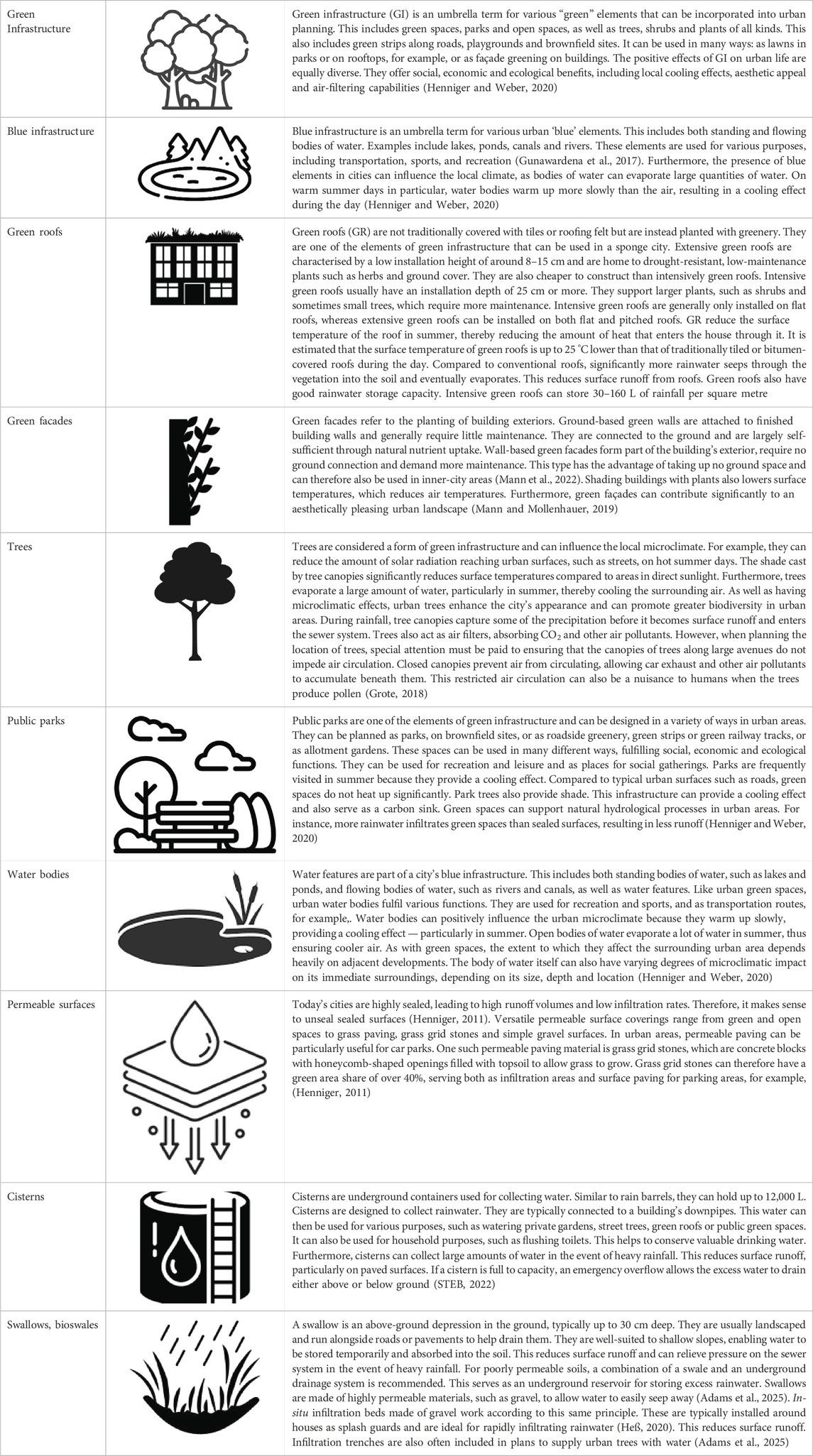
Table 1. Elements of the sponge city (own compilation).
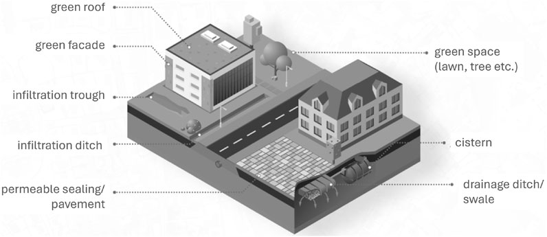
Figure 1. Concept of the sponge city including the elements listed in Table 1 (own illustration).
The concept of a sponge city, also known as a water-sensitive city, aims to help urban areas adapt to climate change. It addresses two conflicting issues: On the one hand, it tackles water scarcity, urban heat islands and drought; on the other, it addresses flooding and inundation (Chan et al., 2022). In a sponge city, rainwater is collected and stored for efficient use. Furthermore, the design of a sponge city reduces the risk of flooding in the event of heavy rainfall. To achieve this, a sponge city is designed to absorb, store and gradually release water into its environment, much like a sponge. This requires various measures, primarily blue-green infrastructure such as green and open spaces, water features and green roofs, as well as cisterns to collect rainwater (Huiting, 2019; Table 1). The primary goal of the sponge city is to reduce urban runoff, allow rainwater to infiltrate urban soils, and collect it for use in irrigation. Furthermore, the elements of the sponge city are intended to positively influence the microclimate of cities (Yang et al., 2022). Natural hydrological processes such as evaporation, transpiration, surface runoff, and infiltration are greatly affected by urban structures and how urban morphology alters the terrain. Evaporation is the process by which water changes from a liquid to a gaseous state. This can cool the surrounding air through evaporative cooling, thereby influencing the local microclimate (Hao et al., 2023). Evaporation occurs when water evaporates from surfaces. Transpiration is the release of water vapour by plants. Here, too, the evaporating water can cool its surroundings. Infiltration is the entry of water into the soil. This water can be used by plants, evaporate, or infiltrate into groundwater (Manoli et al., 2019).
Surface runoff primarily occurs on sealed surfaces, such as roads, commercial land, squares and parking areas, because rainwater cannot infiltrate them. On unsealed surfaces, such as lawns, meadows and green roofs, runoff only occurs after infiltration. This occurs as soon as the soil is completely saturated with water (Jiang et al., 2025; Dyck and Peschke, 1982). There are various types of infiltration, including surface infiltration, trench infiltration and infiltration swales. With surface infiltration, water infiltrates an unsealed surface. This form of infiltration requires a relatively large amount of space, but it can help to relieve the burden on the sewer system (Lapointe et al., 2022). Furthermore, water evaporates from these surfaces. Like surface infiltration, infiltration swales are a decentralised infiltration measure. Swales are often found on roadsides and can be permanently planted with vegetation. Usually between 20 and 30 cm deep, they relieve pressure on the sewer system by allowing rainwater to infiltrate the soil. Swales are also well-suited to temporarily storing water above ground, thus reducing runoff (Sieker and Bandermann, 2024a; Sieker and Bandermann, 2024b). With infiltration through trenches, water infiltrates underground. This is a water storage system located underground that releases water into the ground. These trenches are usually made of gravel or another permeable material and are often used in soils that only allow small amounts of precipitation to infiltrate. This enables water to infiltrate even during periods of heavy rainfall, thereby reducing surface runoff and improving stormwater control (Nodine et al., 2024). Green swales can also be used alongside infiltration trenches (Lapointe et al., 2022).
Advancements in sponge city design are already evident, with large-scale implementations taking place in China’s Sponge City (Li et al., 2017; Qi et al., 2020; Xiang et al., 2019), as well as in the United States, where low-impact development (LID) strategies are employed to manage stormwater at its source and reduce runoff volume (e.g., Asif et al., 2023; Morash et al., 2019). However, the building structures of Chinese and many American cities differ significantly from those of many European cities, which is why this pilot study is so necessary.
The case study
A new urban district in the form of a sponge city called Leipzig 416 is planned for the densely populated, old city of Leipzig in Germany. The city is home to 625,000 people. Spanning approximately 25 ha, the district is set to be constructed on the site of the former freight train station. The district is being developed on the site of the former Leipzig freight rail yard, which is located northwest of Leipzig Central Station. This new development will breathe new life into the currently largely vacant land. Leipzig is one of the fastest-growing cities in Germany due to its high population growth and constant birth rate (Wolff et al., 2023). Therefore, more housing, jobs, daycare centres and schools will be needed in the near future to help Leipzig cope with population growth. The project is still in its infancy and requires extensive planning due to the high demands placed on the new district. The master plan envisages creating an attractive living space adapted to the conditions of climate change. Leipzig 416 is intended to be an ecological showcase district that makes use of many sponge city measures. The plan involves revitalising the entire 25-hectare site to meet all spatial requirements and user demands. The site will be used to create housing, commercial space, educational facilities and recreational areas. Furthermore, the area will be developed to minimise traffic, with a strong emphasis placed on designing cycle and pedestrian paths.
Representatives of the Leipzig City Planning Office have high hopes for the new research project, as they recognise the limitations of existing districts. In new districts, however, planners have the opportunity to take a fresh approach and establish things on a new footing. Nevertheless, cities must adapt as quickly as possible due to climate change, and neither the time nor the resources are available to build new cities. Measures must be taken in existing neighbourhoods, as well as new ones, to make them water-sensitive. Furthermore, forecasts show that the majority of the world’s population will live in cities in the future (Henniger and Weber, 2020). Therefore, addressing this challenge is particularly important. In this context, the 17 Sustainable Development Goals (SDGs) should also be mentioned: SDG11 (‘Sustainable cities and communities’), SDG13 (‘Climate action’) and SDG3 (‘Health and wellbeing’) should encourage more intensive research into implementing sponge city measures in existing urban neighbourhoods.
Set against this background, this paper raises the following questions that require answers.
1. Can sponge city elements be implemented in existing neighbourhoods, whether they are old or prefabricated?
2. Which elements of the sponge city concept can be integrated into existing neighbourhoods and to what extent?
3. What impact could these changes have on neighbourhoods?
Materials and methods
Field sampling preparation
In order to answer the question of the feasibility of implementing sponge city measures in existing neighbourhoods, an overview of the existing buildings and urban areas must first be provided. Paunsdorf, a residential district in the East of Leipzig, is characterised particularly by prefabricated buildings. The Southern Suburb district is located in the South of Leipzig, close to the city centre. It has a high proportion of old residential buildings in classic block construction. These two districts were selected for study because they have different by characteristic urban forms enabling the results to demonstrate the extent to which large parts of the residential area of such a large Central European city are suitable for sponge city elements.
Five elements were selected and mapped for this study: Green spaces, green roofs, in-situ gravel infiltration beds, visible hollows and areas that can be unsealed, primarily parking spaces (see again Table 1). These elements represent measures that could be implemented when converting a residential neighbourhood into a sponge city. All elements are relatively easy to map and provide insight into the current state of existing neighbourhoods with regard to water-sensitive urban planning. Furthermore, the components selected for this study represent green, blue and grey infrastructure. Gray infrastructure refers to grey artificial (built) urban elements, such as roads (Henniger and Weber, 2020).
Various tools were used in advance to efficiently conduct the mapping in the field. These included ESRI’s ArcGIS Pro, ArcGIS Field Maps and ArcGIS Online software, as well as various open geodata sources, such as digital orthophotos of the relevant city districts, the Leipzig city tree cadastre, ALKIS building data with house perimeters, the Leipzig city map and topographic maps of Leipzig. Table 2 shows the portals and sources from which the geodata were retrieved which are publicly accessible which makes all analyses and calculations based on it fully comprehensible.
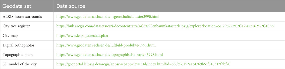
Table 2. Source compilation of open geodata (own representation).
First, the data were reviewed in ArcGIS Pro and assessed for usability. Next, the boundaries of the 25-hectare area were drawn as a polyline for each study area (Figure 2). This enabled the other datasets to be tailored to the study districts, significantly reducing the volume of data. Two datasets were created from the large ALKIS house perimeter dataset: one depicting the house perimeters in the 25-hectare area of the old built-up Southern Suburb, and the other depicting the house perimeters in the 25-hectare area of the prefabricated Paunsdorf. The layer depicting Leipzig’s urban trees was also cropped.

Figure 2. The location of the two study areas in Leipzig and of the city within Germany (with P for Paunsdorf and S for the Southern Suburb). Aerial photographs of the study areas Paunsdorf and Southern Suburb (both with an area of 25 ha; own illustration).
Digital orthophotos with an infrared channel (ground resolution of 20 cm) were used to identify urban green areas. The infrared channel reflects green light with a strong reddish hue, enabling even small green spaces to be identified. Two new layers were then created, named ‘Paunsdorf Green Spaces’ and ‘South Suburb Green Spaces’, and the infrared-reflecting areas were manually digitised as polygons. The ‘Normalised Difference Vegetation Index’ (NDVI) function can then be used in ArcGIS Pro. This creates a raster dataset based on the infrared channel of the orthophotos that highlights green areas. Low pixel values represent sparse vegetation. These include streets, unplanted roofs, and bodies of water. High pixel values indicate areas with a lot of vegetation, such as grassy areas, parks, forests and shrubs (ESRI). After creating the NDVI and manually digitising the green spaces, both datasets was checked for consistency, means, the classification was manual, using NDVI as a visual cue to avoid implying an automated classification. The infrared channel of the orthophotos also revealed whether roofs were covered in greenery. However, no roofs in the study areas had any green cover, either extensive or intensive.
A 3D model of the city of Leipzig was used to identify all the flat roofs in the two study areas. This model provides data on roof shape, among other things, and shows Leipzig in 3D (see Supplementary Material S1a). During the digitisation of green spaces, parking areas were traced manually (see Supplementary Material S1b). To derive the streets, pavements and car parks more accurately from the orthophotos, the Leipzig city map was used. This map shows the city’s most important features, such as streets, pavements and houses. No datasets could be found for the elements ‘in-situ seepage beds’ and ‘troughs’. These are also not visible in the orthophotos. Nevertheless, layers were created for the study areas so that they could be mapped in the field.
The datasets were then uploaded to ArcGIS Online, where they were combined to create a coherent map. ArcGIS Online is a cloud-based platform that can be used to perform various geographic information system (GIS) tasks (ESRI). Users can create layers and maps, and manage and edit their data in ArcGIS Online. Additional applications are also available via ArcGIS Online, including ArcGIS Field Maps. ArcGIS Field Maps is an app designed to enable users to collect data in the field using a mobile device (ESRI). If the mobile device has GPS reception, its location is retrieved and displayed on the map while the app is in use. To include data in the app, a map containing all the necessary layers for fieldwork must first be created. In this case, these layers include green spaces, car parks, in-situ infiltration beds, green roofs, swales, and urban trees. Additionally, a layer was created for each element representing the possibility of implementation, e.g., ‘Green Area Paunsdorf New’ (see Supplementary Material S1a,b).
Before using ArcGIS Field Maps, users can create forms for each layer in the ArcGIS Field Maps desktop application. These forms contain queries that are activated when new data is recorded. For instance, it is possible to create simple queries in the forms about the date and time of data recording. However, it is also possible to create more complex list queries with predefined values. For instance, users can ask a question about the type of green space and specify values such as “lawn”, “meadow” or “forest”. This offers advantages for later data analysis. Text fields can also be added to the form to allow users to add notes and comments. Images can also be taken and attached to each recorded element. Once the forms have been configured, the map and its layers can be shared, making them available to users on the app on their mobile devices.
Field sampling
Fieldwork for this study was conducted in two districts: the Southern Suburb and Paunsdorf. The ArcGIS Field Maps app was used for this purpose, as it makes it easy to record and process data in the field. Various methods were employed during the fieldwork. For example, the presence, position and extent of green spaces, parks, urban trees and house perimeters that had been identified in advance were checked. Data was also added to green spaces and parks. The questionnaire asked for the type of green space for green spaces and the type of park for parks. The options for green spaces were ‘lawn’, ‘overgrown bushes’, ‘ground cover’ and ‘fallow land’. For parks, the surface type of the parking area was categorised as interlocking paving stones, paving stones or asphalt. Furthermore, additional information could be entered into a text field, or images could be uploaded (see Supplementary Material S2). Additional green spaces and parks that could not be identified in the digital orthophotos were mapped and photographed on site.
Similarly, any errors were either corrected immediately or noted for subsequent revision. Green spaces that could be incorporated into the urban landscape were mapped, too. The same procedure was applied to urban trees. If they were not listed in the dataset, they were added as points. During the walkthrough of the study areas, existing in-situ gravel infiltration beds were mapped. Visible depressions were also mapped. Green roofs were not mapped during the fieldwork because they are not visible from the ground. Instead, they were identified using digital orthophotos as mentioned before. A list of indicators was created to determine when a new element could be installed in the study area (Table 3; Figure 3).

Table 3. Indicators for mapping sponge city element potentials.

Figure 3. Schematic representation of the workflow (own illustration).
Modelling of modified water flows after implementing sponge city elements
Surface runoff
Surface runoff occurs when rainwater cannot infiltrate the soil due to precipitation. This can happen if the surface is completely sealed, the soil is already fully saturated with water, or if the intensity of the rainfall exceeds the soil’s infiltration rate. The infiltration rate is the amount of water that infiltrates the soil within a given time frame, typically 1 h (Dyck et al., 1978).
Surface runoff is of great importance in the sponge city concept, as it can potentially lead to flooding. Therefore, runoff in urban areas should be minimised. Runoff particularly occurs on sealed surfaces such as roads, pavements and roofs, where rainwater cannot infiltrate. Therefore, reducing sealed surfaces and ‘desealing’ in sponge cities is important to delay surface runoff in the event of heavy rainfall and relieve the burden on sewer systems (Dyck and Peschke, 1982). Runoff volumes were therefore calculated for the study areas to demonstrate the potential impact of redesigning the area on hydrological processes.
Various methods can be used to calculate runoff, i.e., the amount of water that flows away during rainfall. One of the most well-known calculation methods is the SCS model, which was developed by the US Soil Conservation Service. Developed by the US Soil Conservation Service, the SCS model aims to calculate runoff depending on rainfall amounts and other area-specific conditions, such as soil moisture, soil type and vegetation. Based on numerous measurements in the US, the model uses CN values. The CN value (curve number) represents an area’s maximum storage volume and is influenced by soil type, use, and moisture. CN values are available in tabular form and can range from 0 to 100. A CN value of 0 indicates zero runoff. A CN value of 100 indicates that all precipitation runs off. The table distinguishes between four hydro groups that describe soil permeability. Hydro group A describes soils with a high infiltration capacity of 8 mm/h or more. This group includes deep sandy and gravelly soils, for example,. The infiltration capacity then decreases from hydro group A to hydro group D, which includes soils with a very low infiltration capacity of less than 1 mm/h. The latter include clay soils and virtually impermeable soils.
Direct runoff, also known as effective precipitation, is the result of
where Q is direct runoff (effective precipitation Neff), Ia initial losses (mm) and N the annual precipitation, further
with S as maximum area retention (mm) and
with CN as curve number. The calculation is performed in inches, so the factor of 25.4 is included. This means that the result is calculated in millimetres:
The SCS-CN calculation method takes various factors into account and can provide a sound basis for calculations (Maniak, 2010). However, this method is not suitable for the present study, since it does not account for various surface types, such as green roofs and different types of paved surfaces, which are not listed in the CN value table. Furthermore, it is difficult to estimate the hydro groups. For instance, the CN values for a green area range from 39 to 80. This results in significant deviations in the results.
The runoff coefficient (Ψ) can be calculated from the effective precipitation. This describes the ratio of effective to total precipitation in millimetres and is calculated as follows:
The runoff coefficient method has been used for a long time due to its ease of application. Tabular values for peak and mean runoff coefficients indicate the proportion of precipitation that becomes direct runoff. These values range from 0 to 1. A runoff coefficient of one indicates complete runoff of precipitation, whereas a value of 0 means that no runoff occurs. However, it should be noted that the runoff coefficient method is a significant simplification which, for example, neglects the temporal components of runoff and infiltration. Nevertheless, it is sufficient for obtaining a rough estimate of runoff behaviour in areas. Thus, the runoff volume of an area can be calculated by multiplying the precipitation by the runoff coefficient and the catchment area (AEZG; Dyck et al., 1978):
Infiltration
Rainwater infiltration is crucial for the sponge city concept. In urban areas, an increasing number of surfaces are being sealed off, which prevents rainwater from seeping into the ground. This disrupts natural hydrological processes. On unsealed surfaces, water seeps away and evaporates, feeding into the groundwater. However, in urban areas, the water usually flows into a central sewer system. During periods of heavy rainfall, this can cause problems for urban areas as the sewer system is not designed to drain large volumes of rainwater quickly. Therefore, modelling rainwater infiltration is of great importance in this study (Dyck and Peschke, 1982). Various methods exist for calculating infiltration quantities and rates. The most well-known calculation formulas are the Green–Ampt and Horton models. The Green-Ampt equation assumes that puddles form as soon as precipitation begins and the surface becomes wet with a film of water (Martinez et al., 2021):
where F(t) is the cumulative infiltration rate (cm/h), t time (h), k the saturated conductivity (cm/h), Ψ the suction tension at the moisture front (cm) and Δθ the moisture deficit. The infiltration rate can then be calculated based on the quantity of infiltration with f(t) as infiltration rate:
While the equation is well suited to modelling infiltration behaviour on given soil types, it cannot represent the amount of water that infiltrates green roofs, for example,. The Horton model calculates the initial and final infiltration rates, as well as the recession constant (Dyck and Peschke, 1982):
where f is the infiltration rate, f0 the maximum infiltration rate, K the recession constant, fc the infiltration rate constant and t the time. Table 4 shows the parameter values used to calculate the infiltration rate and quantity for the Horton model.

Table 4. Run-off coefficient parameters for the Horton model for a 15-minute rainfall event (215 L/s*ha) (Schmitt et al., 2007, pp. 48, 49).
These values may not necessarily correspond to reality but can be used to model the infiltration behaviour for the various elements. From the given values, the infiltration quantity can be determined (Maniak, 2010) using with f as infiltration rate:
While the mobile GIS-based fieldwork clearly represents a major strength of this pilot study, the modelling approaches for runoff and infiltration (e.g., Horton model and empirical lookup table runoff coefficients) were simplified and based on generalizations. The study nevertheless assumes that these assumptions are justified, as it does not provide street-specific or even building-specific values, but rather discusses summary values at the neighbourhood scale (once for Paunsdorf and once for the Southern Suburb), where model reliability can be assumed, including the uncertainties that logically arise in a heterogeneous urban land-cover matrix with slightly different road sealing materials, ground vegetation types, or tree heights. As this is a screening pilot field study of a conceptual nature, it was not feasible to calibrate or validate a model using site-specific hydrological measurements, as such data does not exist. The study therefore relied on reference data from literature, which provides reliable values.
Results
The following section provides an overview of the field data collected. In particular, it explains the spatial distribution of the sponge city elements in the study areas.
Greening spaces. The analysis of green spaces revealed a significantly higher density of green spaces in Paunsdorf in comparison to the Southern Suburb. Paunsdorf boasts approximately 126,171 m2 (50.5% of the total case study area) of green space, of which approximately 95% is lawn (Supplementary Material S3.2). The remaining areas are characterised by dense plantations, including shrubbery. In the Southern Suburbs, approximately 23,291 m2 (9.3%) of green space were mapped, of which approximately two-thirds are lawn, approximately 10% are densely planted, and approximately 25% are bound by open cover (Supplementary Material S3.2). The latter phenomenon was particularly prevalent in proximity to trees, typically occurring between parking spaces. The distribution of the area is illustrated in Figure 4a.

Figure 4. Distribution of the different sponge city elements in the two study areas, the prefabricated Paunsdorf and the old built-up Southern Suburb: (a) pavement permeability, (b) number of trees, (c) roof type, (d) surface material, (e) number of swales, (f) implemented and potential in-situ infiltration beds.
In the case of Paunsdorf, however, no such areas were identified that had the potential to be utilised as additional green spaces. In the Southern Suburb, areas between existing green spaces were identified as particularly suitable for new green spaces. The total potential area for new green spaces was approximately 1,455 m2 (0.6%; Supplementary Material S3.2). The area is currently paved with mosaic stones but could be replaced with either a lawn or a water-bound surface, similar to the area surrounding the trees.
Street trees. The analysis of the number of urban trees revealed that the Paunsdorf district has approximately twice the number of trees as the Southern Suburb district. A total of 910 trees were recorded in Paunsdorf, and 447 in the Southern Suburb (Supplementary Material S3.3). Figure 2B illustrates the numerical distribution of urban trees by study area.
Green roofs. The total roof area in Paunsdorf was approximately 50,209 m2 (20.1%), of which 100% were flat roofs (Supplementary Material S3.5). In the Southern Suburbs, the roof area was approximately 80,188 m2 (32.1%), of which approximately 25,466 m2 (10.2%) were flat roofs and approximately 54,721 m2 (25.1%) were pitched roofs. As indicated by the aforementioned indicators, the potential for the implementation of green roofs in Paunsdorf and the Southern Suburb is estimated to encompass an area of 50,209 m2 (20.1%) and 25,466 m2 (10.2%), respectively. The distribution of the area per study area is illustrated in Figure 4c.
During the course of fieldwork, no visible hollows were identified in either Paunsdorf or the Southern Suburb. The indicators for a hollow area in Paunsdorf indicate a total potential area of approximately 50,754 m2 (20.3%; Supplementary Material S3.6). The areas encompassed are predominantly green courtyards, thereby explaining the substantial size of the area. In the Southern Suburbs, the potential hollow area is approximately 6,925 m2 (2.8%; Supplementary Material S3.6). It is conceivable that the area in question could be larger than stated, given that no courtyards could be mapped in the Southern Suburb (Figure 4d).
Infiltration trenches. The analysis of parking spaces as areas where permeable pavements can be installed revealed that there are 39,118 m2 (15.6%) of parking space in Paunsdorf (see Supplementary Material S18). Of this, approximately 78% is asphalt, 3% is paving stones, and 19% is interlocking stones. In the Southern Suburb, the total area of parking space is approximately 17,352 m2 (6.9%; Supplementary Material S3.7). The distribution of this area across different surface types is as follows: 36% asphalt, 10% bonded open pavement, 44% paving stones, and approximately 10% interlocking stones (Figure 4e).
In-situ seepage beds. The analysis of the data on in-situ gravel infiltration beds revealed that approximately 852 m2 (0.34%) are currently available in Paunsdorf and approximately 191 m2 (0.07%) in the Southern Suburb (Supplementary Material S3.8). This finding indicates that the mapping reveals a significantly higher number of infiltration beds in Paunsdorf. It is estimated that there are further potential areas for gravel beds totalling 1,525 m2 (0.61%) in Paunsdorf and 357 m2 (0.14%) in the Southern Suburb (Supplementary Material S3.8; see Figure 4f for area distribution).
Potential for reducing runoff
The calculation of runoff volumes was undertaken utilising data from KOSTRA DWD 2020 for the Paunsdorf and the Southern Suburb areas. The study’s methodology involved the selection of a 15-minute rainfall event exhibiting an annual recurrence interval of 5 years. This results in a rainfall of 18.8 mm or 18.8 L per m2 in 15 min. Such heavy short rainfall events are very typical for Leipzig and occur frequently in the summer and autumn, making them highly significant (https://statistik.leipzig.de/statcity/table.aspx?cat=1&rub=3).
Greening spaces. The analysis of the green spaces revealed a significantly higher number in Paunsdorf in comparison with the Southern Suburb. The total runoff for the 15-minute rainfall event in Paunsdorf was approximately 237 m3. The total runoff for the area in the Southern Suburb during the 15-minute rainfall event was approximately 90 m3. The runoff behaviour of the green spaces is given in Figure 5. In the case of Paunsdorf, however, no suitable areas were identified for the creation of additional green space. In the Southern Suburb area, a potential area for new green space of approximately 1,455 m2 (0.6% of the total case study area) was identified. The area is currently covered with mosaic pavers, and a replacement of these with a lawn or a water-bound cover, as is the case with the adjacent trees, is a possibility. The surface runoff on the area is estimated to be approximately 20.5 m3 during a 15-minute rainfall event. However, this could be reduced to approximately 14 m3 with the implementation of a water-bound open cover. The implementation of a lawn would serve to reduce the volume of runoff from the 0.6% effective area to almost zero (0.003%). As illustrated in Figure 5B, the potential for runoff reduction through the utilisation of green spaces within the Southern Suburb area is evident.

Figure 5. Calculated runoff volumes (in m3) for the current surfaces and the potential Sponge City elements for the prefabricated Paunsdorf and the old built-up Southern Suburb: (a) roof type, (b) land cover, (c) mosaic stone and water-bond open surface types, (d) grass pavers, (e) potential in-situ infiltration beds. The calculation was carried out for a 15-min rainfall event with an annuality of 5 years (resulting in a rainfall of 18.8 mm or 18.8 L per m2).
Green roof potential. The following conclusions were determined when the runoff behaviour on green roofs was evaluated: The presence of green roofs was not observed in either Paunsdorf or the Southern Suburb. A total of 50,209 m2 (20.1%) of green roof was simulated in Paunsdorf. A simulation was conducted for the Southern Suburb, encompassing 25,466 m2 (10.2%) of green roof. The runoff volume in the Southern Suburb area is approximately 411 m3 on flat roofs without green roofs and 812 m3 in Paunsdorf. It has been demonstrated that the implementation of extensive green roofing, with a height of 10 cm or more, on flat roofs in the Southern Suburb area results in a reduction of runoff volume to approximately 95 m3. In the Paunsdorf area, this reduction is approximately 188 m3. It has been demonstrated that the implementation of intensive green roofing, with a height of 30 cm or more, results in a reduction of runoff volume to approximately 48 m3 in the Southern Suburb and to approximately 94 m3 in Paunsdorf. It is estimated that the implementation of intensive greenery measures on flat roofs in the Southern Suburb and Paunsdorf can result in a reduction of runoff by approximately 90% (Figure 5a).
Park area potential. At Paunsdorf, there is a total area of 39,118 m2 (15.6%) of parking space, which is suitable for the simulation of permeable surfaces. In the Southern Suburb, the figure is approximately 17,352 m2 (6.9%). The total runoff for the parking areas in Paunsdorf is estimated to be approximately 639 m3. The grass pavers were modelled as a permeable surface for the designated parking areas. This would serve to reduce surface runoff in Paunsdorf on parking areas during the 15-min rainfall event to approximately 147 m3. This constitutes 23% of the original runoff. In the Southern Suburb, the total surface runoff is approximately 262 m3. The simulation reduced the runoff to approximately 65 m3, which is 25% of the original runoff. As demonstrated in Figure 5c, there has been a marked alteration in surface runoff patterns within parking lots.
In-situ seepage bed potential. The fieldwork indicates that a greater number of in-situ seepage beds could be mapped in Paunsdorf than in the Southern Suburb. The total area of gravel beds in Paunsdorf is estimated to be approximately 852 m2 (0.34%), with an additional 191 m2 located in the Southern Suburb. The total runoff on gravel beds in Paunsdorf is estimated to be approximately 3 m3, whereas in the Southern Suburb, it is approximately 0.7 m3 (Figure 4d). It is estimated that there are a further 1,525 m2 (0.61%) of potential gravel beds in Paunsdorf and 357 m2 (0.14%) in the Southern Suburb. It is important to note that the additional in-situ seepage beds in the Southern Suburb are simulated on mosaic stones with adjoining granite slabs, and in Paunsdorf on lawns. Consequently, surface runoff in the Southern Suburb is reduced by additional in-situ seepage beds, while it increases in Paunsdorf. In the Southern Suburb, surface runoff on the new area would be reduced from approximately 5 m3 to approximately 1.3 m3. In Paunsdorf, runoff on the new areas would increase from approximately 2.9 m3 to approximately 5.7 m3. However, it must be considered that during a rainfall event, precipitation water can seep through the loosely laid gravel surface more quickly than into the lawn (Figure 5e).
Infiltration
Rainwater infiltration is a pivotal component in the functioning of the sponge city. In urban areas, an increasing number of surfaces are being sealed, thereby preventing rainwater from seeping into the ground. This has the effect of disrupting natural hydrological processes. In the case of unsealed surfaces, water seeps away and evaporates, and can be fed into the groundwater. Instead, the water typically flows into a central sewer system. In the event of a heavy rainfall event, these conditions can become problematic for urban areas, as the sewer system is not designed to drain large volumes of rainwater in a short period of time. Consequently, rainwater infiltration is of significant importance and will be modelled as part of this study (Dyck and Peschke, 1982).
Green roof infiltration potential. In Paunsdorf, 50,209 m2 (20.1%) of green roof were simulated, and in the Southern Suburbs, approximately 25,466 m2 (10.2%). It is evident that, in accordance with the established parameters for the calculation of infiltration, the simulation may be conducted for both green roofs with an installation height of less than 10 cm and green roofs with an installation height of 10 cm or more. The infiltration rate on a green roof with an installation height of less than 10 cm during a 15-minute rainfall event is approximately 24.3 mm/h. On a green roof with an installation height of 10 cm or more, the infiltration rate for a 15-min rainfall event is approximately 40.7 mm/h. The cumulative infiltration rate on a green roof with an installation height of less than 10 cm is approximately 6.2 mm per square metre. This indicates that approximately 310 m3 of water can infiltrate the entire roof area in Paunsdorf, and approximately 157 m3 in the Southern Suburbs. On a green roof with a height in excess of 10 cm, the cumulative infiltration rate per square metre is approximately 10.2 mm. This indicates that approximately 515 cubic metres of water could infiltrate the roofs of Paunsdorf, and approximately 261 m3 could infiltrate the Southern Suburbs. As demonstrated for all different measures in Figure 6, this phenomenon is evident.
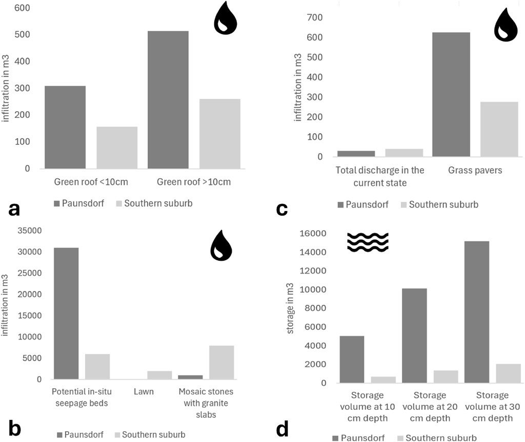
Figure 6. Calculated infiltration rate (in m3) and storage capacity (in m3; d) for the current surfaces and the potential Sponge City elements for the prefabricated Paunsdorf and the old built-up Southern Suburb: (a) green roof depth, (b) surface type, (c) potential in-situ infiltration beds, and (d) storage volume at different soils depths. The calculation was carried out for a 15-min rainfall event with an annuality of 5 years (resulting in a rainfall of 18.8 mm or 18.8 L per m2).
Greening spaces. In the Leipzig area, the predominant soil types are pseudogleyic cambisols with topsoils of silty-loamy sand. Consequently, the surface stabilisation of fine sand/loamy sand was selected for the calculation of infiltration behaviour. For the sake of simplicity, areas mapped as water-bound open cover are also included herein. In Paunsdorf, 126,171 m2 (50.5%) of green space were mapped, and in the Southern Suburb, 23,291 m2 (9.3%). It is evident from the given parameter values for the infiltration calculation that the resultant infiltration rate is approximately 28 mm/h. The cumulative infiltration rate per square metre is approximately 10.4 mm. Consequently, in Paunsdorf, approximately 1,316 m3 of rainwater can infiltrate the entire green space. In the Southern Suburb district, approximately 243 m3 of precipitation can infiltrate the existing green spaces. The potential new green spaces, measuring 1,455 m2 (0.6%), have the capacity to infiltrate an additional 15 m3 of water. In the absence of green spaces, these areas would infiltrate approximately 4 m3.
Park area infiltration potential. In Paunsdorf, 39,118 m2 (15.6%) of parking area was mapped, and in the Southern Suburb district, 17,532 m2 (7.01%). The calculation of infiltration was conducted by dividing the areas into two distinct categories: “pavement with joints” (hereinafter referred to as area type 1) and “asphalt” (hereinafter referred to as area type 2). The area designated as type 1 encompasses surfaces composed of interlocking stone and paving stone, in addition to water-bound open surfaces. This results in an area of 8,389 m2 for area type 1 in Paunsdorf and approximately 30,729 m2 (12.3%) for area type 2. In the Southern Suburbs, approximately 11,207 m2 (4.5%) fall into area category 1, while category two encompasses approximately 6,325 m2 (2.5%). It is evident from the given parameter values for the infiltration calculation that the resultant infiltration rate is approximately 14.4 mm/h for area type 1 and 0 mm/h for area type 2. The cumulative infiltration rate for area type 1 is approximately 3.6 mm per square metre. It has been determined that water does not penetrate area type 2. In Paunsdorf, this results in an infiltration rate of approximately 30 m3 across the entire park area, and approximately 40 m3 in the Southern Suburbs. The specified parameter values for grass pavers result in an infiltration rate of approximately 63 mm/h for a 15-minute rainfall. The cumulative infiltration volume is estimated to be approximately 16 mm per square metre. The infiltration volume for Paunsdorf can now be simulated at a total of approximately 626 m3, and for the Southern Suburb at approximately 277 m3 (Figure 6b).
In-situ seepage bed infiltration. In Paunsdorf, 852 m2 (0.34% of the total case study area) of existing in-situ infiltration beds were mapped, and in the Southern Suburbs, 191 m2 (0.07%). The calculation of the infiltration rate was performed using a loose gravel surface as the experimental site. It is evident from the given parameter values that the 15-minute rainfall event resulted in an infiltration rate of approximately 23.4 mm per hour. The cumulative infiltration rate per square metre is approximately 5.9 mm. This results in an infiltration rate for the area of the existing in-situ infiltration beds of approximately 5 m3 in Paunsdorf and approximately 1.1 m3 in the Southern Suburbs. A total area of approximately 1,525 m2 (0.61%) was identified as suitable for the establishment of new gravel beds in Paunsdorf, with a further area of around 357 m2 (0.14%) deemed suitable in the Southern Suburb. In Paunsdorf, the new gravel beds are simulated on grass, while in the Southern Suburbs, they are simulated on mosaic stones with adjacent granite slabs due to the local conditions. In Paunsdorf, the volume of water that would infiltrate the areas designated for new in-situ infiltration beds would be reduced from approximately 16 m3 to approximately 9 m3. In the Southern Suburbs, the infiltration rate on the new gravel beds would increase from approximately 1.3 m3 to approximately 2.1 m3 (Figure 6c).
Infiltration trench-based infiltration. For Paunsdorf, 50,754 m2 (20.3%) of troughs were simulated, and in the Southern Suburbs, approximately 6,925 m2 (2.8%). Trough depths of 10 cm, 20 cm, and 30 cm were simulated. The trough volume was calculated by multiplying the trough area by the simulated depth. This variant has been found to be straightforward to utilise and has been demonstrated to simulate a consistently constant trough depth across the entire area of the trough. At a depth of 10 cm, the troughs in Paunsdorf can achieve a total storage volume of approximately 5,075 m3, at a depth of 20 cm, 10,151 m3, and at a depth of 30 cm, 15,226 m3. In the Southern Suburb, the troughs have been observed to achieve a total storage volume of approximately 692 m3 at a depth of 10 cm, 1,385 m3 at a depth of 20 cm, and 2,077 m3 at a depth of 30 cm. As demonstrated in Figure 6d, the storage volume per trough depth is clearly delineated.
Discussion
The results of this empirical study show that prevailing residential neighbourhoods could be designed according to the sponge city concept in a straightforward and efficient manner. Despite the limitations of this study, which does not consider road safety or construction regulations in detail, nor determine whether roofs have the necessary load-bearing capacity for greening, the results presented here convincingly demonstrate the huge potential of greening and desealing measures in old built-up cities to store water and enhance the in-situ cooling function for residents. In terms of feasibility or capacity, no individual DIN standards exist for the planning and implementation of intensive green roofs by German practice in terms of typical load allowances and retrofit constraints; instead, reference is made to a combination of various standards, including the DIN standard 18,531 for roof waterproofing, the FLL Green Roof Guidelines for constructing the vegetation base layer and DIN standard 4102–7 on fire protection.
Analysis of runoff and infiltration modelling clearly shows that Paunsdorf’s prefabricated estate currently aligns more closely with the sponge city concept than the 19th/20th-century built Southern Suburb. The results show that Paunsdorf has more large-scale green spaces, in-situ infiltration beds, and urban trees than the old, block-like structures of the Southern Suburb. This means that, in its current state, Paunsdorf is more in line with water-sensitive urban planning (Huiqing, 2019). Due to the neighbourhood’s high proportion of public green spaces, a large amount of precipitation can infiltrate the soil through surface infiltration, resulting in less surface runoff during rainfall (Matzarakis et al., 2019).
These green areas can evaporate a large amount of this water over time, positively influencing the local microclimate and preventing urban heat islands. In the Southern Suburb, however, rainwater is centrally drained due to the lack of green spaces and in-situ infiltration beds. This results in minimal infiltration of precipitation, which can lead to faster flooding in the event of heavy rainfall. Such data suggests that, in its current state, the Southern Suburb is clearly at a higher risk of superficial flooding and the urban heat island effect in the event of extreme rainfall than the Paunsdorf district. Furthermore, unlike old residential blocks with sloping roofs, Paunsdorf has a large number of flat roofs covering a significant area due to its prefabricated buildings. These buildings have clear advantages for such a transformative change towards a sponge city, as Zwierzchowska et al. (2021) recognised. Due to the flat roofs alone, prefabricated housing districts should, or rather could, receive greater attention in the future when implementing sponge city elements. What is more, roof areas account for an often-underestimated significant proportion of urban space (Henniger and Weber, 2020) and therefore offer significant opportunities for water-sensitive urban planning.
Unlike the Southern Suburb, Paunsdorf also has a large number of green spaces of various sizes between the large buildings (Zwierzchowska et al., 2021), which could be developed into hollows. These spaces could fulfil several sponge city functions simultaneously, such as surface infiltration, infiltration into hollows, and evaporation, thereby preventing superficial flooding and counteracting heat. The Southern Suburb has significantly fewer green spaces, which are primarily small-scale and designed as a front zone for buildings. Regarding the installation of new in-situ gravel infiltration beds, Paunsdorf performs better than the Southern Suburb because, according to the given indicators, adjacent areas such as pavements would hardly be obstructed in the prefabricated Paunsdorf and would therefore be easy to implement. In contrast, in the established Southern Suburb, pavements are often narrow and shaded by mature street trees (Haase and Hellwig, 2022), so there would be insufficient space for an in-situ infiltration bed. An evaluation of the number of urban trees reveals that Paunsdorf, a neighbourhood built in the 1970s, has almost twice as many trees as the Southern Suburb, which was built in the early 20th century.
Furthermore, the on-site inspection revealed that the street trees in Paunsdorf tend to be older and larger, meaning they can have a stronger impact on the local microclimate. The shade they cast reduces the intense warming of urban surfaces, such as streets, and thus helps to counteract the formation of urban heat islands.
Regarding runoff and infiltration behaviour in existing neighbourhoods, it can be said that, due to the large number of green spaces and in-situ infiltration beds, a significant proportion of precipitation in Paunsdorf currently infiltrates through surface infiltration, with less rainwater running off. In contrast, the majority of surfaces in the Southern Suburbs are sealed. This results in less infiltration and more runoff, which is drained into the sewer system. Simulations of the various sponge city elements clearly show that green roofs in Paunsdorf can have a strong positive influence on runoff and infiltration behaviour in the neighbourhood. Current research indicates that green roofs can store between 30 and 160 L of water per square metre (Mann and Mollenhauer, 2019). This results in a lower runoff volume and an increased infiltration volume, which can significantly relieve the burden on sewer systems during periods of heavy rainfall. Additionally, green roofs heat up less than traditional roofs (Gunawardena et al., 2017; Maria and Dagmar, 2020), which could prevent heat buildup in the study neighbourhoods. Implementing swales in green spaces in Paunsdorf would significantly delay runoff formation and could also serve as temporary storage.
However, the potential for additional in-situ infiltration beds in Paunsdorf should be viewed critically, given that the proposed new gravel beds already contain infiltration areas. Although the potential in the Southern Suburb is smaller than in Paunsdorf, individual measures such as greening flat roofs can still influence the neighbourhood’s runoff and infiltration behaviour. This has a less pronounced effect than in Paunsdorf but is still useful for positively influencing the local microclimate and hydrological processes.
It should be noted that the results presented here, as well as the sponge city potential of the examined neighbourhoods, depend heavily on how the districts were planned and designed. For example, due to the construction method used in the Southern Suburb, it is not possible to simulate as many flat roofs or in-situ drainage beds. Paunsdorf’s inventory of water-sensitive urban planning elements is more extensive due to previous neighbourhood planning that placed particular emphasis on green and living spaces. The results therefore demonstrate which existing residential neighbourhoods are best suited to becoming water-sensitive districts and which have the greatest potential for further development according to the sponge city concept. In summary, it is clear that the prefabricated district of Paunsdorf is currently more water-sensitive than the Southern Suburb, which was built in the early 20th century, and that it can be designed to be even more so.
Reflections and uncertainties about the methodological design
Using ArcGIS Field Maps for fieldwork proved to be very successful, as mapping, recording and editing new elements, and verifying local conditions were all straightforward and intuitive. The only issue was the occasionally inaccurate GPS signal. There was a deviation of up to 3.5 m between the actual location of the device and the signal. This meant that some data had to be corrected and reworked subsequently. However, thanks to comprehensive preparation in the form of evaluating digital orthophotos and using open geodata, fieldwork could be carried out quickly on site, with few existing elements needing to be added. In particular, urban trees and in-situ gravel infiltration beds had to be recorded on site. In Paunsdorf, it was easier to record the infiltration beds than in the old built-up Southern Suburbs, as typical for such widespread 19th/early 20th century-built structures, because the buildings were accessible from all sides and not fenced off. In the Southern Suburbs, therefore, a second mapping was needed for the courtyards with access after inquiries to the property management companies, which makes a difference to the mapping in Paunsdorf but guarantees a more complete database.
This pilot study selected six elements for the inventory, including urban trees, green roofs, green spaces, parking areas, visible hollows, and in-situ infiltration beds, and five elements for simulating various runoff and infiltration processes, including green roofs, green spaces, parking areas, visible hollows, and in-situ infiltration beds. Other water-sensitive urban planning elements that could be simulated in urban areas include green façades, cool roofs and open water features. In the Southern Suburbs in particular, cool roofs and green façades could be valuable adaptation strategies in response to climate change. Wall-mounted green façades require little space at street level and could be easily implemented (Mann et al., 2022). Cool roofs have a high albedo and therefore store less energy and heat. They are mostly white and could more easily be implemented on pitched roofs in the Southern Suburbs (Santamouris, 2014). However, not all elements corresponding to the sponge city concept could be mapped and analysed. Further exploration of urban trees and the combination of bioswales and tree pits would be interesting. In this study, trees were simply counted, despite their ability to significantly impact the local microclimate. Providing an overview of the evaporation behaviour and shading effect of trees in neighbourhoods would be informative. However, as complete data on the age, species and size of the trees is unavailable, no conclusions can be drawn in this regard.
Calculating the runoff behaviour of precipitation is a straightforward method of determining the volume of runoff. While it is well suited to the scope of this work, it should be noted that the method significantly simplifies real-world conditions. For example, it does not consider the temporal components of runoff and infiltration processes (Dyck et al., 1978). Generalisations were made in the selection of parameter values for the calculation. For instance, the same parameter values were used for green spaces with dense vegetation (such as bushes and trees) as for green spaces without dense vegetation. The runoff coefficients represent mean values and can vary depending on geographical location, soil type and rainfall intensity. Nevertheless, this method is sufficient for calculating a proper estimate of runoff behaviour (Dyck et al., 1978). This can demonstrate the potential influence of elements on hydrological processes in an urban residential neighbourhood.
The Horton model and the specified parameter values for a 15-minute rainfall event with an intensity of approximately 215 L/s/ha were used to calculate the infiltration quantity and rate. The Horton method can provide an approximate representation of the actual infiltration process. However, depending on the geographical location, soil type, and rainfall intensity, the values can also deviate significantly from real-life conditions. For instance, it does not consider how much rainfall has fallen previously or how moist the soil already is (Dyck and Peschke, 1982). Generalisations were made when calculating the infiltration quantity and infiltration rate, as well as when calculating runoff behaviour, to simplify the calculation. For instance, green spaces with and without substantial vegetation were classified as fine sands and loamy sands, respectively. Therefore, the model used to calculate infiltration behaviour does not necessarily reflect reality; however, it is a useful method for making an initial estimate of the infiltration volume and rate. This calculation is useful for demonstrating the potential impact of sponge city elements on existing neighbourhoods.
In future, more detailed studies should include the effects of tree canopies on infiltration and evaporation. Remote sensing could provide the necessary empirical data for different urban vegetation structures (Wellmann et al., 2023). Similarly, an assessment of the feasibility of implementing green roofs would be desirable, as the potential for implementation is limited in cities with many inclined roofs compared to cities with a majority of flat roofs.
Conclusion
This paper explored the concept of the ‘sponge city’ and its importance in adapting existing residential neighbourhoods to climate change. It examined the feasibility of introducing potential sponge city elements into different neighbourhoods and their potential impact on local microclimates and hydrological processes. Data collected through fieldwork in two districts in Leipzig, Germany—one old and built-up, and the other prefabricated in the 1970s—provide an excellent overview of urban elements that correspond to sponge city properties. The prefabricated district has significantly more and larger flat roof systems, as well as green spaces, urban trees and in situ gravel drainage beds. By contrast, the district from the early 20th century has more paved road surfaces and period-style buildings with pitched roofs, as well as smaller green spaces.
The study clearly demonstrates that prefabricated housing estates have greater potential for water-sensitive design, given these features. Runoff and infiltration behaviour calculations for the neighbourhoods further suggest that greening flat roofs could have a particularly strong positive impact, given their large proportion of the urban area. In both study areas, altering the surface finish of car parks was found to significantly affect precipitation infiltration behaviour. Currently, most parking areas in the neighbourhoods are sealed with asphalt, composite pavers, or paving stones, leading to high runoff volumes and low infiltration rates. Unsealing these areas using grass pavers would reduce runoff, increase infiltration and positively impact urban heat and stormwater events. When remodelling car parking areas, the impact on maintenance and performance in winter conditions, such as blockages and snow, must definitely be considered.
Calculations of runoff and infiltration behaviour for the neighbourhoods show that greening flat roofs could have a particularly strong positive impact given their large proportion of the urban area. In prefabricated neighbourhoods, troughs in green spaces could improve delayed stormwater drainage even further. In both study areas, altering the surface finish of car parks was found to significantly affect the infiltration behaviour of precipitation. Currently, most parking areas in the neighbourhoods are sealed with asphalt, composite pavers or paving stones, which leads to high runoff volumes and low infiltration rates. Unsealing these areas using grass pavers would reduce runoff and increase infiltration. This would be more in line with natural hydrological processes and could have a positive effect on the local microclimate.
In summary, it can be said that existing neighbourhoods have the potential to be transformed in line with the sponge city concept. The opportunities for the meaningful integration of elements depend on the urban area’s structure. These measures could also have a significant positive impact. It should be noted that this study uses specifically defined indicators for the implementation of sponge city measures, which may not necessarily reflect real-life conditions. Nevertheless, this study could encourage further research into the topic as it applies to existing residential urban neighbourhoods. Without climate-adapted neighbourhood design, climate change will have a particularly strong impact on city dwellers.
Data availability statement
The original contributions presented in the study are included in the article/Supplementary Material, further inquiries can be directed to the corresponding author.
Ethics statement
Ethical approval was not required for the study involving humans in accordance with the local legislation and institutional requirements. Written informed consent to participate in this study was not required from the participants or the participants’ legal guardians/next of kin in accordance with the national legislation and the institutional requirements.
Author contributions
DH: Validation, Data curation, Methodology, Conceptualization, Investigation, Writing – original draft, Resources, Writing – review and editing, Visualization, Formal Analysis, Software.
Funding
The author(s) declare that financial support was received for the research and/or publication of this article. This research was funded by the NaturaConnect (Designing a Resilient and Coherent Trans-European Network for Nature and People) Horizon 2020 project (contract No. 101060429).
Conflict of interest
The author declares that the research was conducted in the absence of any commercial or financial relationships that could be construed as a potential conflict of interest.
The author(s) declared that they were an editorial board member of Frontiers, at the time of submission. This had no impact on the peer review process and the final decision.
Generative AI statement
The author(s) declare that no Generative AI was used in the creation of this manuscript.
Any alternative text (alt text) provided alongside figures in this article has been generated by Frontiers with the support of artificial intelligence and reasonable efforts have been made to ensure accuracy, including review by the authors wherever possible. If you identify any issues, please contact us.
Publisher’s note
All claims expressed in this article are solely those of the authors and do not necessarily represent those of their affiliated organizations, or those of the publisher, the editors and the reviewers. Any product that may be evaluated in this article, or claim that may be made by its manufacturer, is not guaranteed or endorsed by the publisher.
Supplementary Material
The Supplementary Material for this article can be found online at: https://www.frontiersin.org/articles/10.3389/fenvs.2025.1653240/full#supplementary-material
References
Adams, R., Grotehusmann, D., Harms, R., Kasting, U., Lange, G., Schneider, F., et al. (2025). Niederschlagsentwässerung von Verkehrsflächen. Available online at: https://www.umwelt.nrw.de/fileadmin/redaktion/Broschueren/niederschlagsentwaesserung_verkehrsflaechen_broschuere.pdf.
Andersson, E., Langemeyer, J., Borgström, S., McPhearson, T., Haase, D., Kronenberg, J., et al. (2019). Enabling green and blue infrastructure to improve contributions to human well-being and equity in urban systems. BioScience 69, 566–574. doi:10.1093/biosci/biz058
Andersson, E., Haase, D., Scheuer, S., and Wellmann, T. (2020). Neighbourhood character affects the spatial extent and magnitude of the functional footprint of urban green infrastructure. Landsc. Ecol. 35, 1605–1618. doi:10.1007/s10980-020-01039-z
Andersson, E., Haase, D., Anderson, P., Cortinovis, C., Goodness, G., Kendal, D., et al. (2021). What are the traits of a social-ecological system? Towards a framework in support of urban sustainability. npj Urban Sustain. 1, 14. doi:10.1038/s42949-020-00008-4
Asif, Z., Chen, Z., Sadiq, R., and Zhu, Y. (2023). Climate change impacts on water resources and sustainable water management strategies in North America. Water Resour. Manag. 37 (6), 2771–2786. doi:10.1007/s11269-023-03474-4
Chan, F. K. S., Chen, W. Y., Gu, X., Peng, Y., and Sang, Y. (2022). Transformation towards resilient sponge cities in China. Nat. Rev. Earth Environ. 3, 99–101. doi:10.1038/s43017-021-00251-y
Dyck, S., and Peschke, G. (1982). Grundlagen der Hydrologie. Berlin (West): Publishing house for architecture and technical sciences.
Dyck, S., Becker, A., Flemming, G., Gluga, G., Golf, W., Grünewald, U., et al. (1978). Angewandte hydrologie teil 2. Berlin: VEB Verlag für Bauweisen.
Egerer, M., Haase, D., McPhearson, T., Frantzeskaki, N., Andersson, E., Nagendra, H., et al. (2021). Urban change as an untapped opportunity for climate adaptation. npj Urban Sustain. 1, 22. doi:10.1038/s42949-021-00024-y
Elmqvist, T., Andersson, E., McPhearson, T., Bai, X., Bettencourt, L., Brondizio, E., et al. (2021). Urbanization in and for the anthropocene. npj Urban Sustain 1, 6. doi:10.1038/s42949-021-00018-w
Endlicher, W. (2012). Einführung in die Stadtökologie - Grundzüge des urbanen Mensch-Umwelt-Systems. Eugen Ulmer Verlag, 1.
Grote, R. (2018). Bäume in der Stadt sind nützlich - aber nicht immer und überall. Available online at: https://themenspezial.eskp.de/metropolen-unterdruck/stadtklima-verbessern/stadtbaeume-sind-nuetzlich-aber-nicht-ueberall-3788/.
Gunawardena, K., Wells, M., and Kershaw, T. (2017). Utilising green and bluespace to mitigate urban heat island intensity. Sci. Total Enviroment 584-585, 1040–1055. doi:10.1016/j.scitotenv.2017.01.158
Haase, D. (2009). Effects of urbanisation on the water balance – a long-term trajectory. Environ. Impact Assess. Rev. 29, 211–219. doi:10.1016/j.eiar.2009.01.002
Haase, D., and Hellwig, R. (2022). Effects of heat and drought stress on the health status of six urban street tree species in Leipzig, Germany. Trees, Forests and People 8, 100252. doi:10.1016/j.tfp.2022.100252
Hao, L., Sun, G., Huang, X., Tang, R., Jin, K., Lai, Y., et al. (2023). Urbanization alters atmospheric dryness through land evapotranspiration. npj Clim. Atmos. Sci. 6, 149. doi:10.1038/s41612-023-00479-z
Heß, T. (2020). Spritzschutz fürs Haus: so bleibt die Fassade sauber. Available online at: https://www.haus.de/bauen/spritzschutz-fuers-haus-30067 (Accessed March 10, 2023).
Huang, C., Liu, K., Ma, T., Xue, H., Wang, P., and Li, L. (2025). Analysis of the impact mechanisms and driving factors of urban spatial morphology on urban heat islands. Sci. Rep. 15, 18589. doi:10.1038/s41598-025-04025-0
Jiang, Y., Wang, L., Xie, T., Li, R., Wen, K., Liu, C., et al. (2025). Study on the effect of underlying surface changes on runoff generation in the urbanized watershed. Sci. Rep. 15, 15056. doi:10.1038/s41598-025-95295-1
Kabisch, N., Kraemer, R., Masztalerz, O., Hemmerling, J., Pueffel, C., and Haase, D. (2021). Impact of summer heat on urban park visitation, perceived health and ecosystem service appreciation. Urb For. Urb Green 60, 127058. doi:10.1016/j.ufug.2021.127058
Kabisch, N., Remahne, F., Ilsemann, C., and Fricke, L. (2023). The urban heat island under extreme heat conditions: a case study of hannover, Germany. Sci. Rep. 13, 23017. doi:10.1038/s41598-023-49058-5
Lapointe, M., Rochman, C. M., and Tufenkji, N. (2022). Sustainable strategies to treat urban runoff needed. Nat. Sustain 5, 366–369. doi:10.1038/s41893-022-00853-4
Leisenheimer, L., Wellmann, T., Jänicke, C., and Haase, D. (2024). Monitoring drought impacts on street trees using remote sensing - Disentangling temporal and species-specific response patterns with Sentinel-2 imagery. Ecol. Inform. 8, 102659. doi:10.1016/j.ecoinf.2024.102659
Li, H., Ding, L., Ren, M., Li, C., and Wang, H. (2017). Sponge city construction in China: a survey of the challenges and opportunities. Water 9 (9), 594. doi:10.3390/w9090594
Lin, B., Ossola, A., Ripple, W., Alberti, M., Andersson, E., Bai, X., et al. (2021). Cities and the “new climate normal”: ways forward to address the growing climate challenge. Lancet Planet Health 5, e479–e486. doi:10.1016/s2542-5196(21)00135-2
Maniak, U. (2010). Hydrologie und Wasserwirtschaft - eine Einführung für Ingenieure. Springer Verlag.
Mann, G., and Mollenhauer, F. (2019). BuGG-Fachinformation - positive Wirkungen von Gebäudebegrünungen (Dach-, Fassaden-und Innenraumbegrünung). Available online at: https://www.gebaeudegruen.info/fileadmin/website/downloads/buggfachinfos/Dachbegruenung/BuGG_Fachinfo_Positive_Wirkungen_Positionspapier_20-04-2022.pdf (Accessed February 25, 2024).
Mann, G., Gohlke, R., and Wolff, F. (2022). BuGG Market Report Building Green 2022 - roof, Facade and Interior Greening Germany (in German: BuGG-Marktreport Gebäudegrün 2022 - Dach-,Fassaden-und Innenraumbegrünung Deutschland). Available online at: https://www.gebaeudegruen.info/fileadmin/website/downloads/buggfachinfos/Marktreport/BuGG-Marktreport_Gebaeudegruen_2022.pdf (Accessed February 25, 2024).
Manoli, G., Fatichi, S., Schläpfer, M., Yu, K., Crowther, T. W., Meili, N., et al. (2019). Magnitude of urban heat islands largely explained by climate and population. Nature 573, 55–60. doi:10.1038/s41586-019-1512-9
Maria, K., and Dagmar, H. (2020). Green roof effects on daytime heat in a prefabricated residential neighbourhood in Berlin, German. Urban For. Urban Green. 53, 126738. doi:10.1016/j.ufug.2020.126738
Martinez, C., Vojinovic, Z., Price, R., and Sanchez, A. (2021). “Modelling infiltration process, overland flow and sewer system interactions for urban flood mitigation,” in Urban runoff control and sponge city construction. doi:10.3390/w13152028
Matzarakis, A., Kasang, D., Grassl, A., Breckle, S.-W., and Lozan, J. (2019). “Städte im Klimawandel,” in Warnsignal Klima: die Städte. doi:10.25592/uhhfdm.9360
Morash, J., Wright, A., LeBleu, C., Meder, A., Kessler, R., Brantley, E., et al. (2019). Increasing sustainability of residential areas using rain gardens to improve pollutant capture, biodiversity and ecosystem resilience. Sustainability 11 (12), 3269. doi:10.3390/su11123269
Nodine, T. G., Conley, G., Riihimaki, C. A., Holland, C., and Beck, N. G. (2024). Modeling the impact of future rainfall changes on the effectiveness of urban stormwater control measures. Sci. Rep. 14, 4082. doi:10.1038/s41598-024-53611-1
Qi, Y., Chan, F. K. S., Thorne, C., O’Donnell, E., Quagliolo, C., Comino, E., et al. (2020). Addressing challenges of urban water management in Chinese sponge cities via nature-based solutions. Water 12 (10), 2788. doi:10.3390/w12102788
Santamouris, M. (2014). Cooling the cities – a review of reflective and green roof mitigation technologies to fight heat island and improve comfort in urban environments. Sol. Energy 103, 682–703. doi:10.1016/j.solener.2012.07.003
Schmitt, T., Welker, A., Illgen, M., Bosseler, B., Harting, K., and Brüggemann, T. (2007). Abschlussbericht - Untersuchung des Abfluss-und Versickerungsverhaltens wasserdurchlässiger Flächenbeläge. Available online at: https://www.ikt.de/website/down/f0132langbericht.pdf (Accessed March 10, 2024).
Sieker, H., and Bandermann, S. (2024a). Rigolen. Available online at: https://www.sieker.de/fachinformationen/regenwasserbewirtschaftung/versickerung/article/rigolen-185.html (Accessed March 10, 2024).
Sieker, H., and Bandermann, S. (2024b). Versickerungsmulden. Available online at: https://www.sieker.de/fachinformationen/regenwasserbewirtschaftung/versickerung/article/versickerungsmulden-156.html (Accessed March 10, 2024).
STEB (2022). Information Regenwasser-Zisterne. Available online at: https://www.paderborn.de/microsite/steb/abwasserberatung/merkblaetter.php.media/207379/flyer_paderborn_zisterne_3_web.pdf (Accessed March 8, 2024).
Weber, N., Haase, D., and Franck, U. (2014). Zooming into the urban heat island: How do urban built and green structures influence earth surface temperatures in the city?. Sci. Total Environ. 496, 289–298. doi:10.1016/j.scitotenv.2014.06.144
Wellmann, T., Andersson, E., Knapp, S., Lausch, A., Palliwoda, J., Priess, J., et al. (2023). Reinforcing nature-based solutions through tools providing social-ecological-technological integration. Ambio 52, 489–507. doi:10.1007/s13280-022-01801-4
Wolff, M., Haase, D., Priess, J., and Hoffmann, T. L. (2023). The role of brownfields and their revitalisation for the functional connectivity of the urban tree system in a regrowing city. Land 12, 333. doi:10.3390/land12020333
World Cities Report (2024). World Cities Report 2024. Available online at: https://unhabitat.org/wcr/.
Xiang, C., Liu, J., Shao, W., Mei, C., and Zhou, J. (2019). Sponge city construction in China: policy and implementation experiences. Water Policy 21 (1), 19–37. doi:10.2166/wp.2018.021
Yang, D., Zhao, X., and Anderson, B. (2022). Integrating sponge city requirements into the management of urban development land: an improved methodology for sponge city implementation. Water (Basel). 14, 1156. doi:10.3390/w14071156
Keywords: sponge city, climate change, heat, heavy rainfall, old built-up cities, permeability, green infrastructure, desealing
Citation: Haase D (2025) Sponge city in existing housing stock – more of a dream or reality?. Front. Environ. Sci. 13:1653240. doi: 10.3389/fenvs.2025.1653240
Received: 24 June 2025; Accepted: 22 September 2025;
Published: 19 November 2025.
Edited by:
Abbas Roozbahani, Norwegian University of Life Sciences, NorwayReviewed by:
Zuzana Vranayová, Technical University of Košice, SlovakiaChen Song, University of Twente, Netherlands
Copyright © 2025 Haase. This is an open-access article distributed under the terms of the Creative Commons Attribution License (CC BY). The use, distribution or reproduction in other forums is permitted, provided the original author(s) and the copyright owner(s) are credited and that the original publication in this journal is cited, in accordance with accepted academic practice. No use, distribution or reproduction is permitted which does not comply with these terms.
*Correspondence: Dagmar Haase, ZGFnbWFyLmhhYXNlQHVmei5kZQ==