 Junhao Liu
 Jiulin Li1,2*
 Yingxing Wang
- 1School of Architecture and Planning, Anhui Jianzhu University, Hefei, China
- 2Anhui Collaborative Innovation Centre for Urbanization, Hefei, China
Assessing the ecosystem resilience and risks of metropolitan areas helps coordinate ecological environmental protection, reduce landscape ecological risks, and enhance ecological resilience. Existing studies often analyze the trade-offs and synergies between landscape ecological risks and ecological resilience within specific regions based on administrative divisions. However, the mechanisms underlying these trade-offs and synergies across different scales remain unclear. This study focuses on the Hefei Metropolitan Area in China, constructing quantitative assessment models for ecological resilience and landscape ecological risks from a landscape pattern perspective. It systematically examines the spatiotemporal evolution characteristics of these two aspects from 2010 to 2020 across multiple scales, including grid, county, and city levels. Pearson correlation analysis and bivariate spatial autocorrelation are employed to investigate their spatial interactions. Furthermore, a coupling coordination model is used to identify trade-offs and synergies between the two at different scales. Finally, based on the interaction analysis, tailored zoning regulation strategies are proposed. Key findings reveal: (1) Over the past decade, the landscape ecological risk in the Hefei Metropolitan Circle has exhibited characteristics of “stable overall pattern with localized differentiation,” where high-risk zones are predominantly concentrated in areas with elevated water body ratios. Ecological resilience exhibited a slight declining trend, with an overall low resilience level. High-resilience zones experienced a significant reduction of 50.6% in area, while low-resilience zones expanded toward the core urbanization areas. (2) A robust negative correlation emerged between ecological resilience and landscape risk, intensifying significantly with finer spatial scales. Crucially, the recoverability dimension exerted the most potent counteracting effect on risk propagation. (3) The mean coupling coordination degree between ecological resilience and ecological risk across multiple scales registered below 0.5, with spatial heterogeneity manifesting as “higher in the southwest and generally low in other areas.” Coordination zones are sporadically distributed within southwest woodlands, while dysregulation zones concentrate predominantly in water bodies and urbanization-intensive belts. (4) Collectively, low-resilience/high-risk zones clustered in waterbody-dense areas, contrasting with high-resilience/low-risk clusters predominantly occupying forested biomes. This spatial divergence exhibited scale-dependent amplification under finer resolutions. Synthesizing multiscale correlations and coupling coordination patterns, we delineate a four-type governance typology. This study provides both theoretical underpinnings and practical pathways for multi-scale collaborative governance to enhance regional ecological resilience and advance sustainable development.
1 Introduction
Since its Reform and Opening Up, China has undergone the most extensive and rapid urbanization in human history (Zhang and Wang, 2025). During 4 decades of economic growth and spatial proliferation, human built infrastructure has superseded vast natural land covers, driving transformative reconfiguration of regional ecosystem structures (Li et al., 2024; Meimei et al., 2023; Ren et al., 2024; Wang C. et al., 2025; Yang et al., 2018). These dramatic land use transformations have not only accelerated biodiversity erosion and habitat fragmentation (Fletcher et al., 2018; Su et al., 2024; Yang et al., 2025), but also unleashed cascading landscape ecological perturbations that critically compromise regional ecological security patterns (Wang and Yang, 2025; Zeng et al., 2024; Zhu et al., 2024). Consequently, there is a critical imperative to advance holistic understanding of the process structure function nexus within land use change dynamics. Landscape ecological risk (LER) constitutes the probability of deleterious ecological consequences arising from ecosystems subjected to natural or anthropogenic stressors (Kong et al., 2025; Qiao et al., 2025; Qiu et al., 2025; Wang et al., 2023; Yu and Li, 2024; Zhang H. et al., 2023; Zhang N. et al., 2023) Ecological resilience (ER) denotes the capacity of ecosystems to maintain core structures, functions, and biodiversity through dynamic processes of resistance, adaptation, and recovery when confronting internal/external stressors. This capacity fundamentally hinges on the structural stability of regional ecosystem configurations (Feng et al., 2024; Jiang et al., 2025; Li K. et al., 2025; Tang et al., 2025; Wang and Liu, 2024; Yin et al., 2024). As a geospatial entity integrating biophysical and anthropogenic elements, landscapes experience amplified ecological risks when subjected to urban expansion induced terrain modifications and intensified anthropogenic pressures. These perturbations compromise structural stability of ecosystems, ultimately diminishing ER through self-reinforcing degradation cycles. Hence, deciphering the coupled dynamics between LER and resilience constitutes a pivotal theoretical frontier one essential for resolving ecological security dilemmas in rapidly urbanizing regions and advancing nature positive futures.
Currently, LER and ER stand as pivotal concerns in ecological security research, attracting extensive scholarly engagement. Most scholars regard ER and LER as two independent scientific issues, conducting extensive research on their assessment methods, spatiotemporal patterns, and influencing factors, respectively. At the theoretical level, LER research focuses on quantifying potential threats to ecosystems under anthropogenic activities or natural disturbances. Predominant assessment frameworks employ the “disturbance-vulnerability-loss” model, integrating Landscape Pattern Index (LPI) analysis, probabilistic modeling, and multi-source data fusion techniques. These approaches enable dynamic risk monitoring through risk classification, spatial heterogeneity analysis, and identification of driving factors (Wang F. et al., 2025; Yang et al., 2024; Zhang et al., 2024). ER theory emphasizes an ecosystem’s adaptive and restorative capacities in response to disturbances. The research paradigm has progressively shifted from static assessments toward dynamic simulations, increasingly employing the “resistance-adaptation-recovery” framework. This approach reveals the evolutionary dynamics of system resilience through resilience network modeling, threshold identification, and adaptive cycle models (Wang S. et al., 2025; Wu et al., 2025). For instance, Shamuxi et al. developed a three dimensional assessment framework based on landscape disturbance, vulnerability, and loss dimensions to evaluate the spatiotemporal evolution of ecological risk in the Tarim River Basin, providing a scientific basis for regional ecological security (Shamuxi et al., 2025). Li et al. quantified ecological risk within the riparian buffer zone of the Luo River in Shaanxi Province using the LER Index (LERI) method, establishing a theoretical framework for regional risk management (Li Z. et al., 2025). Fan et al., employing a Pressure-State-Response (PSR) ER assessment framework, provided new insights into the dynamic interplay between regional spatial transformation and ER (Fan and Wei, 2025). Currently, research integrating ecological resilience and ecological risk remains limited both at the theoretical level and in conceptual exploration, with a lack of relevant empirical case studies. Some scholars have linked ecosystem services or ecological resilience with ecological risk to establish relatively balanced research frameworks. For instance, Wang et al. assessed the dynamics of ecosystem services and ecological risks by combining historical analysis and future predictions, identifying four distinct functional ecological zones (Wang X. et al., 2025). Xu et al. proposed an adaptive zoning framework through a comprehensive analysis of ecosystem service value and landscape ecological risk (Xu F et al., 2025). However, although existing studies have yielded fruitful results, merely using ecosystem services or ecological resilience to represent an ecosystem’s capacity to mitigate risks is insufficient. There remains significant room for deepening theoretical integration and practical application: most research remains confined to a single perspective and lacks exploration into systematically integrating the “disturbance-vulnerability-loss” risk model with the “resistance-adaptation-recovery” resilience framework. Such integration is crucial for comprehensively capturing the complex feedback loops between the transmission pathways of risk pressures and the dynamic responses of ecosystem coping capacities during urbanization. Furthermore, most studies focus on descriptive analyses of spatiotemporal evolution patterns and differentiation characteristics, while actionable zoning management and collaborative optimization strategies based on risk-resilience coupling mechanisms are relatively scarce. This gap makes it difficult to effectively support the refined management of regional sustainable development.
As highly heterogeneous and dynamic complex ecosystems, metropolitan areas cannot be fully captured in terms of the interactive relationships between LER and ER through a single-scale analysis. Relying solely on adjacent scales may overlook their scale dependent characteristics, thereby making it difficult to reveal the mechanisms by which the same factor influences the tradeoffs and synergies between the two across multiple scales. This could ultimately lead to mismatched management strategies at different scale levels. Against the backdrop of rapid urbanization in China exacerbating regional land use changes, investigating the tradeoffs and synergies between LER and ER (and their subsystems) across multiple scales is crucial for future urban management. However, current academic understanding of the cross-scale tradeoffs and synergistic variations between the two remains insufficient, which constrains regional managers’ ability to regulate key influencing factors and limits the enhancement of regional ER. Therefore, from a landscape pattern perspective, exploring the tradeoffs and synergies between LER and ER (including their subsystems) across multiple scales, and identifying key resilience subsystems that constrain risks, holds significant theoretical and practical importance. Such an approach can guide managers at different levels in rapidly urbanizing areas to develop targeted, context-specific strategies for reducing regional LER and enhancing ER.
The Hefei Metropolitan Area serves as a key growth engine driving the rise of central China, a strategic core zone safeguarding the ecological shield of Chaohu Lake, and a crucial hub promoting coordinated regional development by connecting the eastern and western parts of the country. Its ecological security construction and context specific ecological zoning management are of great significance. Since the 21st century, as one of the fastest growing emerging metropolitan areas, Hefei has undergone rapid urbanization, with extensive natural surfaces being replaced by artificial built environments, placing severe pressure on the regional ecosystem. However, existing research lacks exploration of the spatiotemporal characteristics, tradeoffs, and synergies between LER and ER across multiple scales in the Hefei Metropolitan Area. This gap poses challenges for policymakers in developing evidence based, tailored management strategies. Therefore, this study selects the Hefei Metropolitan Area as the research region to bridge the aforementioned theory-practice gap. Its core theoretical contribution lies in the innovative integration of the “disturbance-vulnerability-loss” LER model with the “resistance-adaptation-recovery” ER framework to establish a coupled assessment system. This integration is particularly suited for analyzing metropolitan systems characterized by high intensity disturbances, significant vulnerability, and strong spatial heterogeneity. It enables the simultaneous examination of the spatiotemporal evolution and interactive coupling relationships between ER and risks across different scales. Through coupled assessment, key zones such as “high-risk-low-resilience,” “low-risk-high-resilience,” and “dynamic risk-resilience areas” can be identified, providing a direct basis for formulating differentiated zoning management strategies and enhancing the ecological security and sustainable development resilience of the Hefei Metropolitan Area. This study addresses the following questions: 1) How do the tradeoffs and synergies between LER and ER (including its subsystems) differ at the 3 × 3 km grid, county, and city scales? 2) How do the mechanisms underlying these tradeoffs and synergies at different scales influence zoning management in the metropolitan area? The detailed research workflow is illustrated in Figure 1.
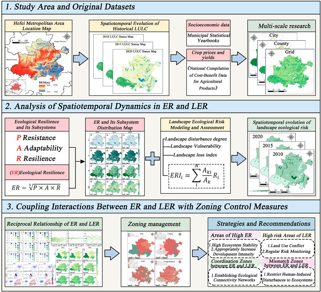
Figure 1. Research framework diagram.
2 Materials and methods
2.1 Study area
The Hefei Metropolitan Circle is located at the geographical pivot of eastern China (30°57′–32°32′N, 116°41′–118°52′E) (Figure 2) (Dai et al., 2025; Fan et al., 2022). The region exhibits a composite geomorphic structure: the Jiang Huai Divide transects its eastern western axis, while the northern sector predominantly comprises the extended Huang Huai Plain. Centrally, undulating hills and interlaced valleys dominate, whereas the southern zone features an interdigitated distribution of riparian wetlands and low elevation foothills. Hydrologically, the area demonstrates characteristic dual basin dynamics, with the Yangtze and Huai Rivers constituting primary drainage arteries, supplemented by 18 major tributaries including the Chao Lake and Chu River systems. This geographic template engenders three distinct ecological gradients: an eastern riparian wetland corridor along the Yangtze, a central complex urban ecotone, and a western ecological barrier formed by the Dabie Mountain foothills. Collectively, they foster diverse natural ecosystems and anthropogenic environments, constituting a region of pivotal ecological significance. However, accelerated urbanization in recent years has imposed significant pressure on regional ecosystem stability through expanding urban footprints and intensified anthropogenic disturbances. This has triggered a marked increase in LER frequency across the region. As the primary economic growth hub in central China, the Hefei Metropolitan Circle now necessitates urgent investigation into the spatiotemporal dynamics of its ecological “resilience-risk” nexus. Targeted zoning governance strategies must be developed to advance regional high quality development and ecological civilization advancement.
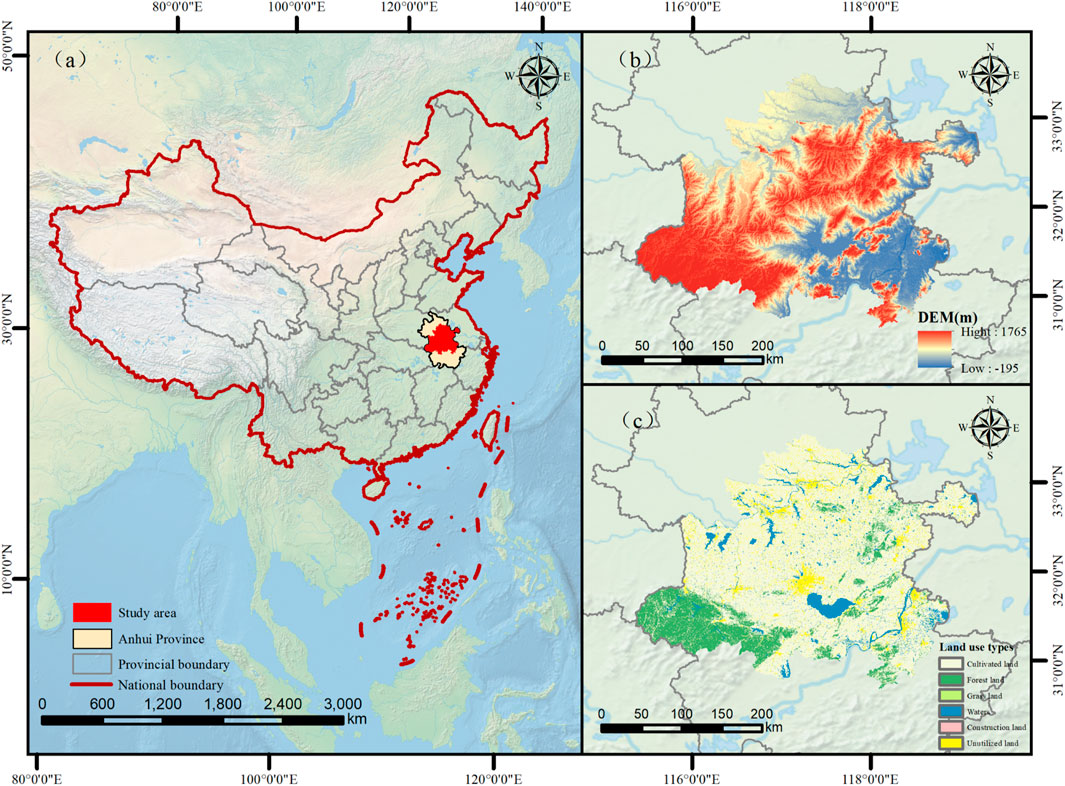
Figure 2. Overview of the study area: (a) Location of the study area in China; (b) Elevation map; (c) Land use type map.
2.2 Data sources
The year 2010 marked the conclusion of China’s 11th Five Year Plan, 2015 was both the final year of the 12th Five Year Plan and a pivotal year for environmental legislation, while 2020 represented the end of the 13th Five Year Plan and the year of China’s carbon neutrality commitment. Therefore, selecting these 3 years for studying ecological resilience and ecological risks allows for capturing the entire process of China’s macro strategic transition from “growth-first” to “green development.” Accordingly, this study utilizes land use data and socioeconomic data from the three periods of 2010, 2015, and 2020. All remote sensing imagery underwent standardized preprocessing including image cropping, atmospheric correction, and geometric rectification prior to analysis. Detailed data sources are provided in Table 1.
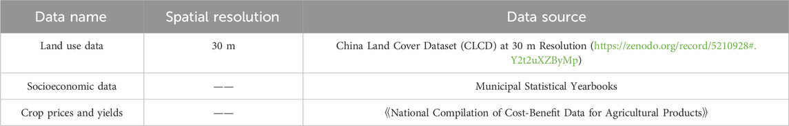
Table 1. Sources of information.
2.3 Research methods
2.3.1 ER construction
Resistance (P): Ecosystems with rich biodiversity and stable structures inherently possess enhanced functional integrity, enabling them to mitigate external pressures through self-regulatory mechanisms and thereby exhibit greater resistance. Consequently, this study quantifies resistance using Ecosystem Service Value (ESV). This approach integrates multiple functional dimensions including provisioning, regulating, and supporting services within a unified assessment framework. Through a value coefficient matrix that captures the ecological contribution of distinct land cover types, we objectively characterize regional ecosystem resistance levels (Wang and Ge, 2024). See specifically Equation 1.
Where:
Adaptive Capacity (
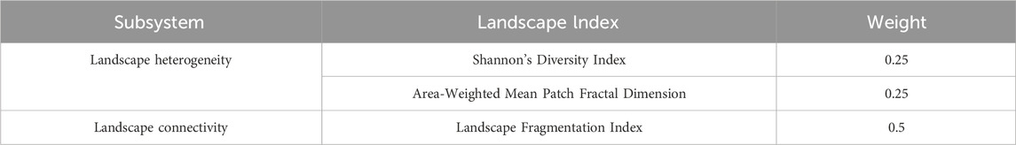
Table 2. Landscape indices and their weights.
Recovery Capacity (
Where:
Ecological Resilience (
2.3.2 LER assessment
Landscape disturbance degree (
Where:
Landscape Vulnerability quantifies the susceptibility of distinct landscape types to degradation or functional loss under external disturbances, reflecting their inherent structural fragility and resistance capacity. Building on regional characteristics and established methodologies (Wang et al., 2025a), we implemented a Delphi informed weighting protocol to classify landscape vulnerability into six hierarchical tiers (highest to lowest). Tier scores were subsequently normalized via min-max scaling to derive standardized vulnerability indices (
Table 3. Landscape vulnerability.
The landscape loss index (
The ecological risk index (
Where:
2.3.3 Correlation analysis
To systematically elucidate interaction mechanisms among LER, ER, and their subsystems, we established a statistical verification framework for variable relationships. Given the characteristics of continuous variable data, Pearson correlation coefficient analysis was employed to test the significance of bivariate linear associations. This method effectively achieves unit invariance through covariance normalization, rendering it superior to alternative correlation techniques for linear relationship quantification in continuously distributed geospatial data.
2.3.4 Correlation analysis
This study employs bivariate spatial autocorrelation to analyze the spatial association between LER and ER (including its subsystems). The spatial dependency is revealed through global Moran’s I calculation and local Moran’s scatter plot mapping. The global Moran’s I (ranging from −1 to 1) quantifies the strength of spatial association between variables: Positive values indicate spatial clustering of similar attributes (e.g., adjacent areas exhibit concurrent high/low ER and risk levels; values approaching 1 denote significant spatial correlation). Negative values suggest spatial divergence (e.g., high resilience areas adjacent to low-risk zones). Zero values represent random spatial distribution. The local Moran’s scatter plot categorizes spatial clusters into four types: High-High (H-H): High ER with high LER. High-Low (H-L): High ER with low LER. Low-Low (L-L): Low ER with low LER. Low-High (L-H): Low ER with high LER. The calculation formula follows reference (Lee, 2001).
2.3.5 Coupling coordination model
LER quantifies potential adverse consequences to ecosystems arising from natural or anthropogenic disturbances, whereas ER underscores a system’s capacity to adapt, recover, and reorganize following such disruptions. Both concepts probe the stability and dynamic response mechanisms of ecosystems, exhibiting multifaceted intrinsic interconnections. This study investigates the reciprocal relationship between regional scale LER and ER by implementing a modified coupling coordination model. See specifically Equations 10–12.
Where:
Table 4. Coupling coordination types.
3 Results
3.1 Spatiotemporal evolution of ER
To investigate the spatiotemporal evolution of ER and its subsystems within the Hefei Metropolitan Circle during 2010–2020, Figure 3 was constructed. This analysis reveals pronounced spatiotemporal heterogeneity in regional ER and its components. Regarding resistance, a “high-periphery, low-core” spatial pattern persisted throughout the study period, with over 93% of grid units consistently classified as medium-low or lower levels, indicating minimal temporal variation. Conversely, adaptability exhibited diametrically opposed characteristics, maintaining high performance across all timeframes; grids with medium-high or higher adaptability exceeded 57% in all three temporal dimensions. The spatial configuration of recovery closely mirrored that of resistance, yet demonstrated a persistent decline: the proportion of grids with medium-high or higher recovery decreased from 27.04% (2010) to 27.00% (2015) and 26.24% (2020), signaling a gradual but sustained deterioration. Spatially, ER hotspots predominantly clustered in the northern sector, while over 60% of the region remained below medium-high resilience thresholds. Temporally, Table 5 underscores a systematic transition in ER dynamics over the decade. Deconstructing resilience hierarchy reveals critical shifts: Low resilience zones displayed dual expansion a 6.7% net area increase (+0.67 percentage points in spatial coverage) evidencing intensified pressure from rapid urbanization on ecologically vulnerable areas. Medium-low resilience zones contracted by 1.97 percentage points yet maintained dominant coverage (60.67%), reflecting inherent regional ecological fragility. Medium-resilience zones registered concurrent growth in area (+5.5%) and spatial proportion (+1.21%). High-resilience zones suffered precipitous declines, with area plummeting by 50.6% and spatial share diminishing to 0.54%. These findings collectively demonstrate suboptimal regional ER levels, necessitating urgent spatially differentiated governance frameworks tailored to local contexts to enhance holistic ER.
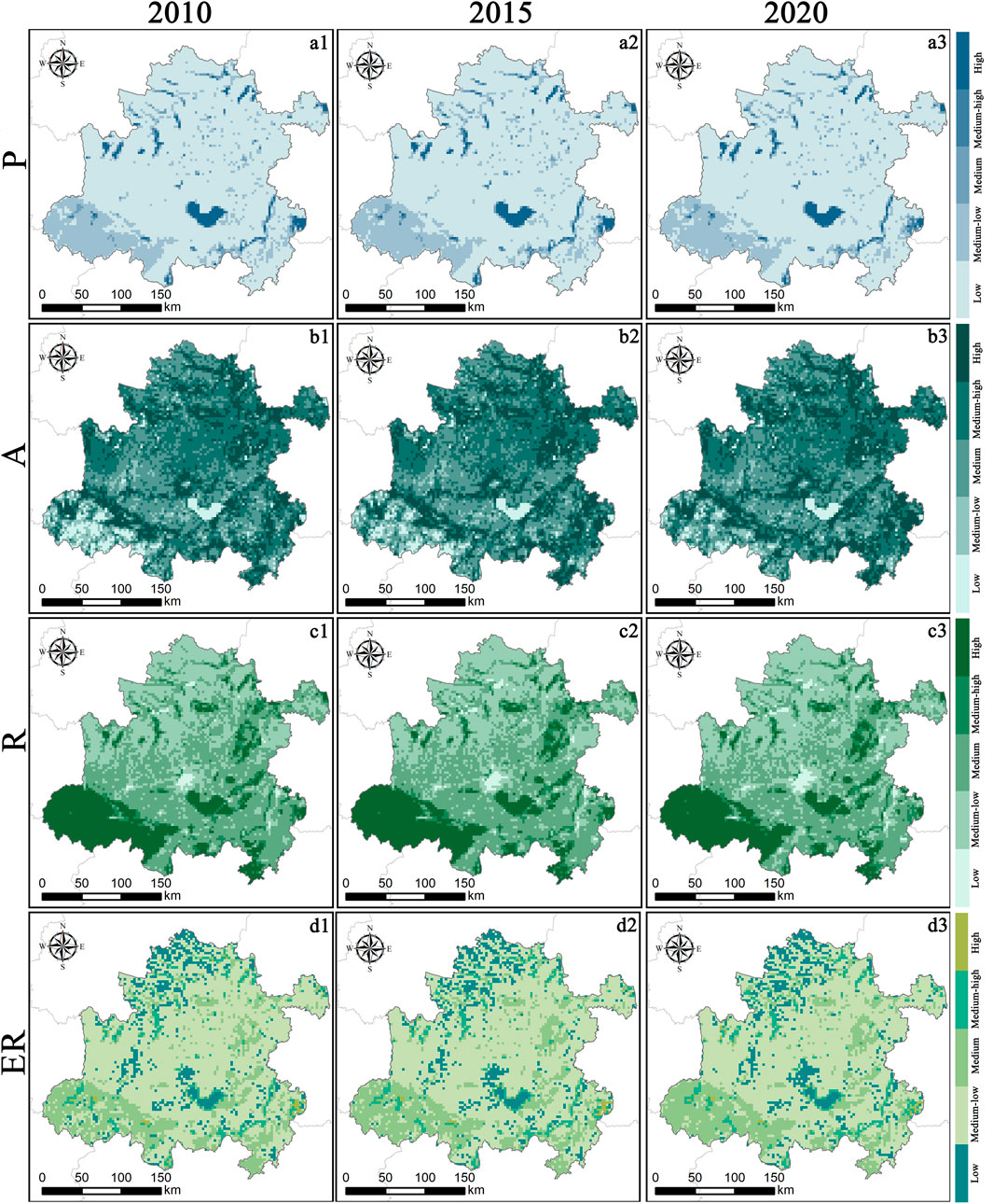
Figure 3. Spatiotemporal evolution of ER and its subsystems in Hefei Metropolitan Circle (2010-2020): (a1-a3) Resistance Dimension; (b1-b3) Adaptability Dimension; (c1-c3) Resilience Dimension; (d1-d3) Ecological Resilience.
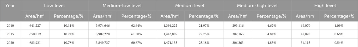
Table 5. Area and proportion of ER levels in Hefei Metropolitan Circle from 2010 to 2020.
3.2 Spatiotemporal evolution of LER
To further investigate the spatiotemporal evolution of LER in the Hefei Metropolitan Circle (2010–2020), Figure 4 and Table 6 were developed. Key findings reveal divergent temporal trajectories across risk hierarchies: Low-risk areas experienced continuous contraction, decreasing from 1.3488 million hectares (21.26%) in 2010 to 1.2853 million hectares (20.26%) in 2020, indicating progressive encroachment on natural ecological baselines. Moderately low risk areas consistently dominated the landscape, with coverage increasing marginally from 68.70% to 69.53%, reflecting sustained stability in fundamental ecological conditions. Moderate risk areas exhibited minimal fluctuation, rising only 0.12 percentage points (4.63%–4.75%), suggesting localized ecological pressures remain manageable. Moderately high risk and high risk areas demonstrated counteracting trends: the former declined from 3.98% to 3.91%, while the latter increased from 1.43% to 1.55%, revealing heightened vulnerability in zones impacted by intensive anthropogenic activities. Spatially, low risk zones concentrated in the southwestern region with higher forest coverage, whereas high-risk areas clustered around water bodies. Overall, the ecological risk pattern demonstrated a “stable baseline with localized differentiation,” necessitating vigilance against the expansion of high risk zones and their potential threats to ER.
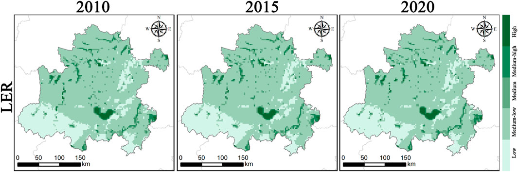
Figure 4. Spatiotemporal evolution of LER in the Hefei Metropolitan Area (2010–2020).
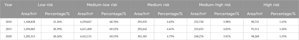
Table 6. Area and proportion of different LER levels in the Hefei Metropolitan Area (2010–2020).
3.3 Interactive relationship between LER and ER
3.3.1 Correlation analysis of LER and ER
This study employed Pearson correlation analysis to reveal the multi-scale interactions between LER and ER (including its subsystems) in the Hefei Metropolitan Circle from 2010 to 2020 (Figure 5). Temporally, the negative correlation between ER and LER intensified at both municipal and county scales during the study period. Notably, at the county scale, the correlation coefficient between LER and ER decreased cumulatively by 164.5% over the decade, indicating increasingly pronounced inhibitory effects of cumulative ecological risks on resilience systems at finer administrative scales. Across scales, recovery capacity consistently exhibited the strongest negative correlation with LER in all three study periods. At the municipal scale, correlation coefficients remained below −0.72, while values at the county and grid scales were less than −0.55 and −0.13, respectively. Additionally, significant positive correlations were observed between ER and its subsystems, suggesting synergistic interactions within the resilience framework. These findings collectively underscore the hierarchical and scale dependent nature of risk-resilience dynamics, with recovery capacity emerging as a critical buffer against regional ecological risks.

Figure 5. Heatmap of multi-scale correlation between LER and ER from 2010 to 2020.
3.3.2 Bivariate spatial autocorrelation
Table 7 presents the bivariate Moran’s I test results for the spatial autocorrelation between LER and ER (including its subsystems) in the Hefei Metropolitan Circle across multiple scales from 2010 to 2020. The analysis reveals that finer spatial scales amplify the significance of correlations between LER and ER metrics. At the municipal scale, only adaptive capacity exhibited a moderately significant positive correlation with LER (P < 0.05),while other correlations remained weak (At the municipal scale, the sample size falls below the empirically recommended value for general spatial autocorrelation analysis, and this result may lack stability.). In contrast, at the county scale, recovery capacity demonstrated a strongly significant negative correlation with LER (P < 0.001, Z <−72),whereas adaptive capacity mirrored this pattern with an extremely significant positive correlation (P < 0.001, Z > 10). At the grid scale, all subsystems of ER showed highly significant correlations (P < 0.001), with LER:ER and recovery capacity exhibited significant negative correlations; Resistance and adaptive capacity displayed significant positive correlations. Notably, the negative correlation between ER and LER at the grid scale intensified annually over the study period. These findings highlight the critical role of spatial granularity in uncovering complex risk-resilience interactions, with grid-scale analysis providing the highest sensitivity to localized ecological dynamics.
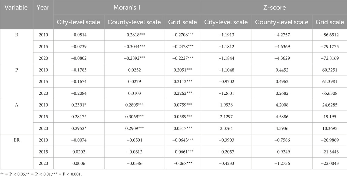
Table 7. Results of bivariate Moran’s I test for LER and ER (including its subsystems) across multiple scales from 2010 to 2020.
To further analyze the spatial autocorrelation between LER and ER (including its subsystems) across multiple scales, this study presents Figures 6–9. A comparative analysis across different scales reveals that as the research scale becomes more refined, the spatial correlation between LER and ER (and its subsystems) gradually strengthens, and the spatial clustering effect becomes more pronounced. The bivariate Moran’s index between LER and ER at both the county and grid scales shows a gradual increase over time, indicating a continuous enhancement of their negative spatial correlation. Among the subsystems of ecological resilience, only restorative capacity (R) consistently exhibits a certain degree of negative spatial correlation with LER across all three scales.
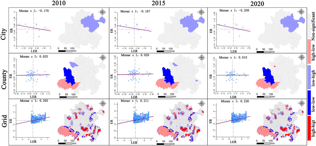
Figure 6. Bivariate Moran scatter plots and LISA maps of landscape ecological risk and resistance (P) in the Hefei Metropolitan Circle at multi-scales from 2010 to 2020.
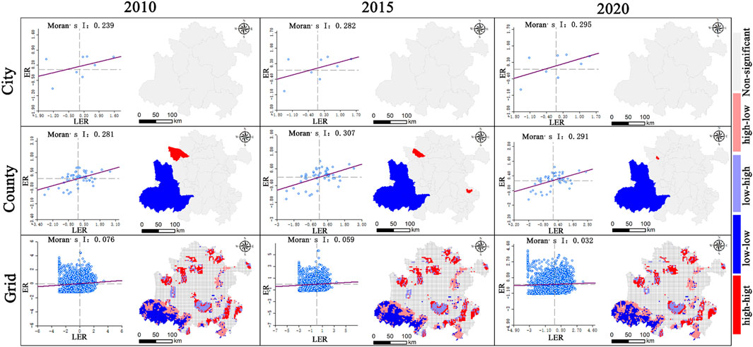
Figure 7. Bivariate Moran scatter plots and LISA maps of landscape ecological risk and adaptability (A) in the Hefei Metropolitan Circle at multi-scales from 2010 to 2020.
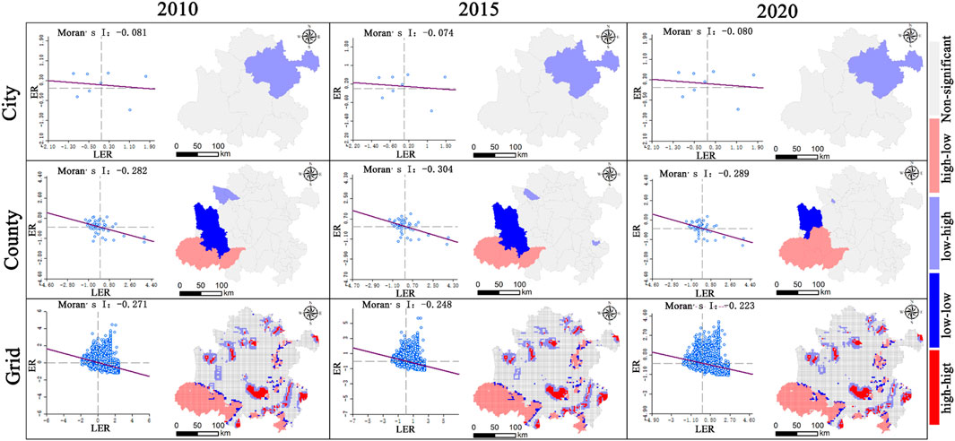
Figure 8. Bivariate Moran scatter plots and LISA maps of landscape ecological risk and resilience (R) in the Hefei Metropolitan Circle at multi-scales from 2010 to 2020.
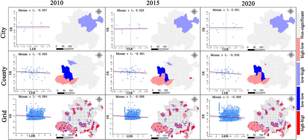
Figure 9. Bivariate Moran scatter plots and LISA maps of landscape ecological risk and ecological resilience in the Hefei Metropolitan Circle at multi-scales from 2010 to 2020.
From a spatial distribution perspective, Figures 6, 7, 9 exhibit highly consistent spatial characteristics: At the city scale, the low-high clusters are consistently distributed within Chuzhou City, while the remaining areas show no significant spatial correlation. At the county scale, the low-low clusters are primarily located in the western part of the Hefei Metropolitan Area, including Huoqiu County, Yu’an District, Yeji District, and Jin’an District. The high-low clusters align with the distribution patterns observed at the grid scale, mainly concentrated in the southwestern part of the metropolitan area, encompassing counties such as Jinzhai, Huoshan, and Shucheng. At the grid scale, the high-high clusters are predominantly distributed in the northern and southeastern regions of the Hefei Metropolitan Area, while the low-high clusters are primarily aggregated around the Chaohu Lake watershed. Figure 8 reveals the spatial autocorrelation between adaptive capacity (A) and LER: At the city scale, no significant spatial correlation is observed. At the county scale, low-low clusters are distributed in the southwestern counties of the metropolitan area. At the grid scale, high-high clusters are sporadically scattered across the northern and eastern regions, as well as the periphery of Chaohu Lake. The low-low clusters align with the high-low clusters identified in the spatial autocorrelation analysis between other ecological resilience subsystems and landscape ecological risk, primarily located in the southwestern forested areas with high vegetation coverage.
3.4 Coupling coordination analysis between LER and ER and its subsystems
Figure 10 presents box plots illustrating the coupling coordination relationships between LER and ER (including its subsystems) in the Hefei Metropolitan Circle across multiple scales from 2010 to 2020. The results demonstrate that the mean coupling coordination degree between LER and ER remained below 0.5 at all scales, indicating a marginally coordinated state. Temporally, the coupling coordination across all three scales exhibited a slight downward trend, reflecting weakened synergies over the study period. Spatially, municipal-scale coupling coordination degrees showed outliers approaching zero, suggesting minimal regional heterogeneity, while the county scale exhibited the highest number of outliers, highlighting significant inter-county disparities. In contrast, grid-scale outliers were relatively smaller, emphasizing localized consistency in risk-resilience dynamics. These findings collectively indicate a persistent trade-off relationship between LER and ER in the Hefei Metropolitan Circle during the study period, where improvements in one metric often coincided with deteriorations in the other. This antagonistic interaction underscores the necessity for spatially differentiated governance strategies to address scale-specific ecological challenges.

Figure 10. Box plots of coupling coordination relationships between LER and ER (including its subsystems) at multiple scales (2010–2020).
Table 8 and Figure 11 present the spatial proportions and distribution of coupling coordination levels between LER and ER in the Hefei Metropolitan Circle across multiple scales from 2010 to 2020. The results reveal that, except for minor high-coupling-coordination areas at the municipal scale, county and grid scales exhibited predominantly low coordination levels. Spatially, the municipal scale was dominated by a “mildly uncoordinated” state, while “critically uncoordinated” states prevailed at county and grid scales. Temporal analysis highlighted significant divergence in coordination evolution across scales. At the municipal scale, the proportion of “extremely uncoordinated” areas remained unchanged at 18.08% over the decade, indicating persistent structural ecological challenges likely constrained by rigid macro-planning or systemic governance delays. A sudden surge in “severely uncoordinated” areas to 6.40% in 2015 (absent in other years) suggested potential transient ecological disturbances or data anomalies during this period. At the county scale, the proportion of “extremely uncoordinated” zones decreased from 2.25% to 0.82%, reflecting partial alleviation of high-risk pressures through localized governance. However, the “mildly uncoordinated” proportion rose from 14.45% to 18.97%, signaling enhanced diffusion of medium-low risks, potentially linked to marginal effects of land use transitions. The grid scale demonstrated a “polarized stabilization” pattern: the “critically uncoordinated” proportion increased from 48.04% to 51.75%, while the “marginally coordinated” proportion declined from 44.92% to 41.81%, revealing subtle degradation in small-scale coordination likely associated with ecological fragmentation driven by urban expansion. Additionally, the “primary coordination” level showed no significant improvement across scales, suggesting ER-building remains confined to passive adaptation. Overall, the multi-scale evolution of coupling coordination unveiled a “macro-rigidity, meso-improvement, micro-fluctuation” pattern, highlighting the urgent need for cross-scale collaborative governance mechanisms to address spatially heterogeneous challenges of risk transmission and resilience dissipation.
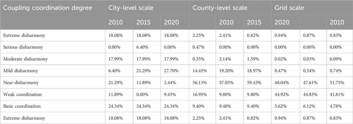
Table 8. Percentage distribution of coupling coordination levels between LER and ER in the Hefei Metropolitan Circle (2010–2020) under multi-scale perspectives (Unit: %).
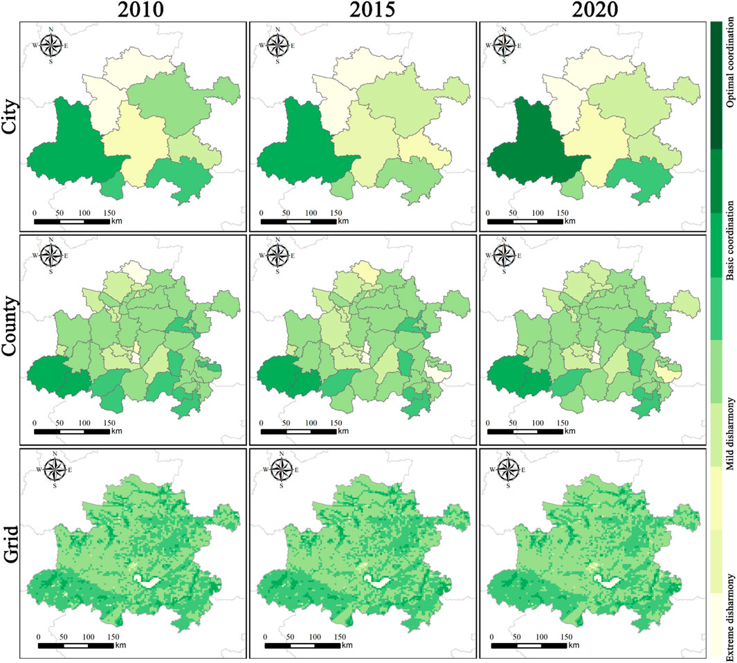
Figure 11. Spatial distribution of coupling coordination levels between LER and ER in the Hefei Metropolitan Circle from 2010 to 2020 under multi-scale perspectives.
3.5 Zoning regulation under multi-scale perspectives
Under multi-scale perspectives, this study employed bivariate local Moran’s indices to delineate the spatial interactions between LER and ER (Figure 9). By further integrating coupling coordination analysis (Figure 11), the Hefei Metropolitan Circle was classified into distinct zoning units across three scales (Figure 12). Synthesizing multi-scale spatial interactions and coupling coordination relationships, the metropolitan circle was categorized into four zones: high-resilience zones, high-risk hotspots, risk-resilience uncoordinated zones, and risk-resilience coordinated zones.
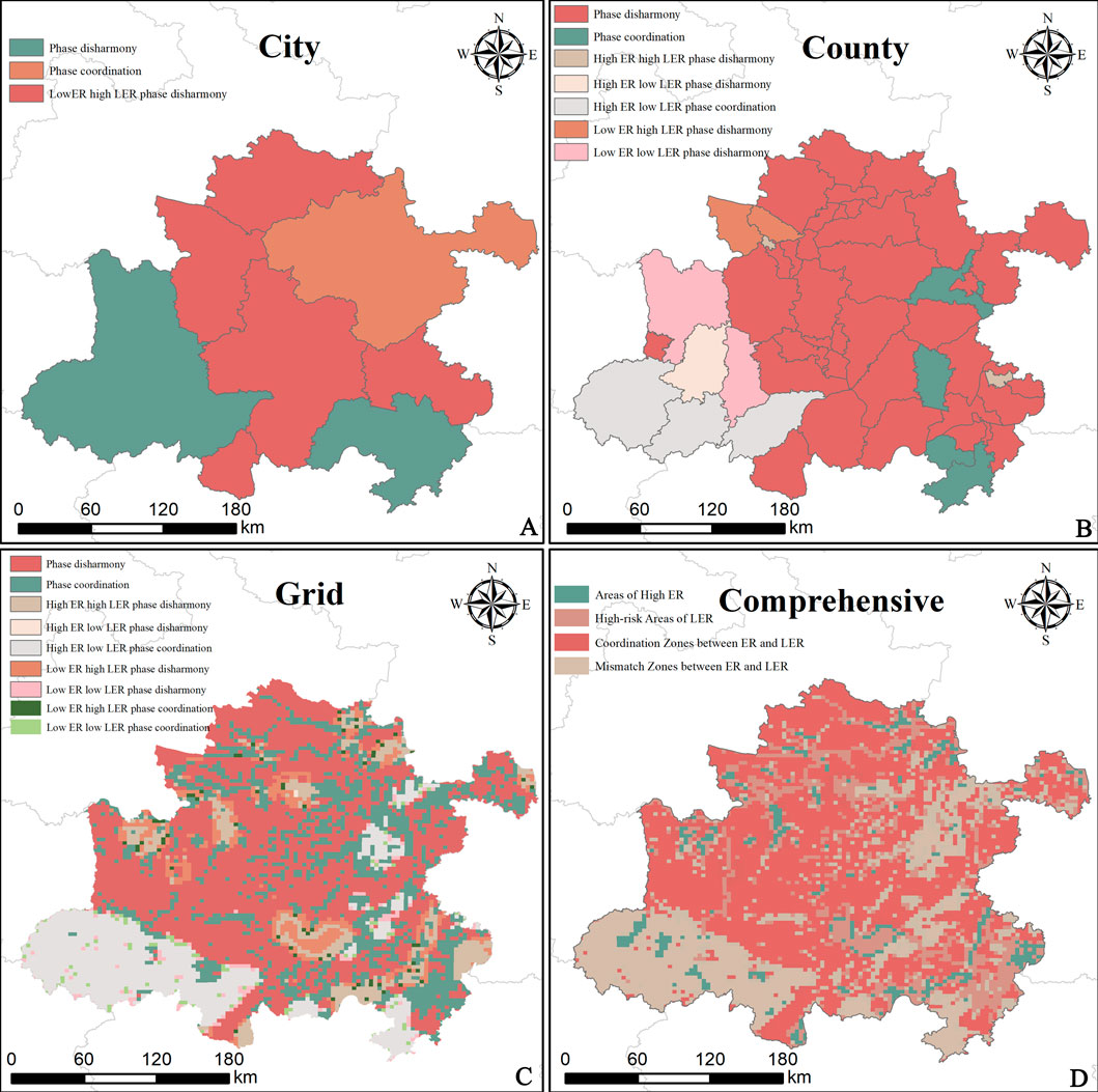
Figure 12. Zoning management of the Hefei Metropolitan Circle from a multi-scale perspective. (A) City-level Scale; (B) County-level Scale; (C) Grid Scale; (D) Comprehensive Scale.
From a coupling coordination perspective, only Lu’an City and Wuhu City exhibited coordinated risk-resilience relationships at the municipal scale, while all other counties remained uncoordinated. At the county scale, coordinated relationships were observed in Nanqiao District, Hanshan County, Fanchang District, and Nanling County, with Jinzhai, Huoshan, and Shucheng Counties representing high-resilience/low-risk coordination. In contrast, grid-scale analysis revealed sporadic coordination in the southwestern and fragmented peripheral areas. Overall, the metropolitan circle demonstrated poor coupling coordination between LER and resilience across all scales. Spatial clustering analysis highlighted strong spatial dependency and negative correlations, particularly at the grid scale. Low-resilience/high-risk zones predominantly clustered in waterbody-rich regions such as Chaohu City and Huoqiu County, whereas high-resilience/low-risk zones concentrated in forest-dominated southwestern counties (Jinzhai, Huoshan, Shucheng). Low-resilience/low-risk and high-resilience/high-risk zones exhibited fragmented spatial distributions. These findings underscore the necessity for spatially adaptive governance strategies to address scale-specific ecological challenges and enhance systemic resilience.
4 Policy and management implications
The spatial interplay between LER and ER exhibits considerable heterogeneity (Figure 12D), necessitating comprehensive management strategies and region-specific mitigation measures informed by a spatial zoning scheme. Areas exhibiting high ER are discretely distributed adjacent to water bodies within the region, correlating with a low incidence of LERs and minimal anthropogenic disturbance. These zones demonstrate robust ecosystem stability and integrity. To optimize their ecological service value for socioeconomic development, strategic intensification of appropriately-scaled development within core protected areas is warranted. Concurrently, natural hydrological processes must be rigorously maintained. Implementing peripheral ecological buffer zones is critical to restrict agricultural non-point source pollution and impervious surface expansion. Furthermore, advancing integrated watershed management supported by ecological compensation mechanisms is essential to harmonize conservation with development. This holistic approach fosters the establishment of a continuous ecological corridor network, thereby enhancing regional ecological connectivity. LER hotspots are predominantly concentrated within the Chaohu Lake area and southeastern regions characterized by extensive water coverage. These ecologically critical zones exhibit pronounced land-use conflicts, where economic development coexists with conservation imperatives. Implementing robust regional coordination strategies is therefore essential. Concurrently, it is imperative to rigorously prohibit activities that encroach upon aquatic ecosystems, such as lake enclosure for agriculture (tian) and lake reclamation for development. Furthermore, regular LER assessments must be conducted to identify potential risk sources and vulnerable areas, enabling the formulation of targeted mitigation strategies. Finally, optimizing land-use structure to reduce unsustainable practices is crucial to mitigate adverse impacts on landscape ecological integrity. Regions exhibiting a mismatch between ER and LER are extensively distributed across non-forested and non-aquatic areas. These zones experience intensive anthropogenic pressure, characterized by high land development intensity driven by urbanization, diminished ER, and landscape configurations approaching critical thresholds of functional disruption. Stringent limitations on ecosystem disturbance are therefore imperative. Establishing a dynamic ecological risk assessment framework is essential, coupled with rigorous lifecycle ecological oversight of construction land. Regular analysis of monitoring data must be implemented to enable timely identification and resolution of emerging issues. Collectively, these measures will foster circular economic practices and advance green industry development. Synergistic zones between ER and LER are primarily concentrated in areas with high forest cover. Characterized by relatively low anthropogenic pressure, these regions exhibit elevated resilience levels and reduced ecological risk. To fully leverage their pivotal role as transitional buffers, stringent protection of core natural forests must be prioritized, including restrictions on commercial logging and large-scale development. Concurrently, bolstering ecological conservation policies should be integrated with leveraging forested landscapes to construct ecological corridor networks. These networks must strategically interface with adjacent farmlands and water bodies, fostering a balance in ecosystem service provision and demand across the broader landscape while significantly enhancing regional ecological connectivity.
5 Discussion
5.1 Spatiotemporal evolution of ER and LER
Our analysis reveals a significant shift in regional ER over the decade: low resilience zones expanded considerably (increasing by 17.3% coverage), while high resilience extremes contracted markedly (decreasing by 12.8% coverage) (Table 5). These shifts likely indicate heightened volatility in ecosystem resilience, suggesting progressive destabilization across specific dimensions. Crucially, this destabilization appears driven by cumulative effects of climate change, natural disasters, and intensified anthropogenic disturbances (Fan et al., 2024). As evidenced in Figure 3d3, the Hefei Metropolitan Circle exhibited a marked expansion of low resilience zones alongside a significant contraction of high resilience areas in 2020. This spatial restructuring is likely attributable to synergistic pressures from extreme precipitation events and accelerated urbanization. Notably, the entire region particularly the Chaohu Lake Basin experienced historically unprecedented persistent rainfall. Water levels in Chaohu Lake surged to an all-time high (13.43 m), sustaining prolonged exceedance above flood alert thresholds throughout the monitoring period. Figure 3 further reveals broad spatial convergence among the subsystems of ER, indicating strong coupling and synergistic interactions between these components (Liu et al., 2022). Consequently, policymakers must adopt integrated approaches for ecosystem management that account for all resilience subsystems. Focusing exclusively on isolated facets while neglecting systemic interdependencies risks compromising holistic resilience outcomes. Effective stewardship requires holistic and systematic strategies to safeguard and enhance the stability of ER.
Analysis of LER patterns revealed that moderate to low risk levels predominated across the Hefei Metropolitan Area over the decade-long study period (Table 6). Both risk categories exhibited marginal yet discernible increases, with high risk zones demonstrating a lower growth rate compared to their moderate to low counterparts. Spatially, low risk clusters were primarily concentrated in southwestern forested regions, whereas high risk areas coincided predominantly with water bodies. These spatial patterns broadly align with existing literature, providing robust evidence for regional risk dynamics. These patterns resonate with established regional observations. For instance, Li et al. documented pronounced spatial heterogeneity in LERs across Harbin over a 20-year period, identifying significant risk clustering proximal to water bodies (Li Y. et al., 2025). Similarly, scenario-based simulations by Ma et al. projected substantial expansion of high-risk zones in Hainan Island under multiple developmental trajectories (Ma et al., 2025). Collectively, these studies underscore the critical influence of hydrographic features on ecological risk agglomeration and validate the robustness of our analytical framework. This resilience may be attributed to targeted governance frameworks implemented by environmental authorities. Local authorities have executed sustained conservation initiatives across the Hefei Metropolitan Area over the past decade, with particular emphasis on the Chaohu Lake watershed. Notable interventions include the Ten Lakeside Wetlands Initiative launched in 2018 and the subsequent enactment of the Chaohu Wetlands Protection Statutes in 2019. Consequently, despite coinciding with China’s most rapid urbanization phase, ecological degradation has been effectively contained—demonstrating that strategic policy interventions can decouple economic expansion from environmental deterioration.
5.2 Interplay between ER and LER
Analysis of subsystem correlations revealed that resilience exhibited the most pronounced negative association with LER. This robust inverse relationship likely stems from the acute sensitivity of resilience metrics to ecosystem stability and integrity where heightened risk directly compromises buffering capacities essential for recovery. The robust negative association between ER (particularly its recovery metrics) and LER underscores the imperative of integrating risk mitigation as a core pillar in environmental governance frameworks. Effective conservation planning requires context-specific interventions that both suppress risk propagation and enhance systemic buffering capacities. The significant negative correlation between ER (including its subsystems) and LER further underscores the critical importance of incorporating LER mitigation as a core consideration in environmental conservation planning. Effective strategies must prioritize the enhancement of ecological resilience through regionally tailored adaptive measures. Critically, our analysis reveals a progressive intensification of the negative correlation between ecological resilience and LER with increasing spatial resolution. This scale-dependent amplification likely stems from inherent scaling effects (Wang C. et al., 2025). Consequently, environmental managers must explicitly account for spatial heterogeneity across administrative and ecological scales when formulating conservation policies or interventions. This multi-scale perspective is fundamental to ensuring both the effectiveness and long-term sustainability of implemented strategies.
Our analysis reveals a notably lower incidence of high coupling coordination values at the grid scale compared to broader spatial extents (Table 8). This pattern likely arises from the finer spatial resolution of grid-scale analysis, which more accurately captures localized heterogeneity and process dynamics (Liu et al., 2023). At broader spatial scales, our results indicate consistently higher coordination levels between landscape ecological risk and ER. This pattern likely reflects the combined influence of spatial averaging effects and the enhanced holistic stability inherent to integrated eco-system functioning. Elevated coupling coordination signifies greater ecosystem stability, where landscape pattern changes exert minimal disruptive influence on regional ER a critical determinant of ecological equilibrium (Zhang M. et al., 2023). Conversely, observed declines in coordination and localized decoupling likely result from the complex interplay of anthropogenic pressures (including resource overexploitation and pollution), climate change impacts, and endogenous ecosystem dynamics. Consequently, we urge policymakers to prioritize evidence-based conservation in future territorial planning by: Safeguarding ecologically sensitive zones and reinforcing critical habitat corridors through integrated ecological networks; Scaling up biodiversity protection initiatives and implementing robust ecological compensation mechanisms to minimize anthropogenic disturbance; Establishing cross-sectoral governance frame works to synchronize landscape configuration with resilience enhancement. his integrated approach is paramount for reconciling development pressures with long-term ecological integrity.
5.3 Limitations and future research directions
Compared to existing studies that predominantly emphasize theoretical analysis, this research introduces innovations in both its theoretical framework and analytical methodology: Firstly, by constructing a multi-scale analytical framework, it systematically reveals the spatiotemporal coupling relationships between LER and ER (including its subsystems), deepening the understanding of dynamic interaction mechanisms and coordinated evolution patterns among these elements. Secondly, moving beyond traditional theoretical limitations, it integrates practical zoning management with theoretical analysis. Based on the spatial heterogeneity and coupling coordination relationships of “resilience-risk,” it identifies which resilience subsystems (resistance, adaptation, or recovery) serve as critical leverage points for regulating regional ecological security. Furthermore, it proposes a spatially adaptive ecological management zoning scheme, providing a scientific basis and implementation pathway for optimizing regional ecological security patterns.
However, this study still has certain limitations. Urban ecological risks originate from complex sources, and the current ecological resilience assessment model fails to cover all dimensions of resilience. A more comprehensive evaluation system should be introduced in future research. The evolution of LER and ER exhibits nonlinear, long-term, and non-stationary characteristics, making a 10-year study period insufficient to fully capture their dynamics. Subsequent research could extend the study period and expand the scale range. Furthermore, the interaction mechanisms between the two warrant deeper exploration, such as multi-scale driving mechanisms and the regulatory role of landscape pattern optimization on resilience. More sophisticated models (e.g., dynamic simulation, agent-based modeling) could be employed for quantitative analysis. Future studies could also strengthen the following aspects: enhancing the analysis of socioeconomic driving mechanisms (e.g., land markets, planning policies) to reveal the profound impacts of human activities on ecosystems; conducting international comparative studies with metropolitan areas such as the Yangtze River Delta and Pearl River Delta to identify commonalities and differences, thereby improving the generalizability of conclusions; and developing predictive policy scenarios, such as simulating trends in landscape ecological risks around Chaohu Lake under different urban expansion rates, to propose preemptive management recommendations.
6 Conclusion
1. The study revealed a significant negative correlation between ER and LER in the Hefei Metropolitan Area, with this negative correlation strengthening as the scale of analysis became more refined. Spatial heterogeneity was particularly pronounced at the grid scale, where the restorative capacity subsystem demonstrated the most prominent inhibitory effect on ecological risks. This finding deepens the understanding of the dynamic feedback mechanism between risk and resilience in highly urbanized areas and addresses a theoretical gap in multi-scale synergistic analysis.
2. This study innovatively identifies the spatial distribution and evolutionary patterns of key areas such as “high-risk–low-resilience” and “low-risk–high-resilience” across three scales (grid, county, and city levels). Based on spatial autocorrelation and coupling coordination analysis, it proposes a spatially adaptive zoning framework with four types of ecological management partitions. These findings break through the limitations of traditional single-scale studies, provide a scientific basis for cross-level and differentiated ecological governance, and represent a significant methodological and applied extension of existing ecological security theories.
3. Through a multi-scale coupling coordination evaluation, this study reveals that the average coupling coordination degree between ER and LER in the Hefei Metropolitan Area is below 0.5, indicating an overall state ranging from on the verge of dysfunction to barely coordinated. Over time, the coupling coordination degree across all three scales shows a slight declining trend. Spatially, coordinated areas are sporadically distributed in the southwestern forested regions, while dysfunctional areas are concentrated around water bodies and highly urbanized zones. At the city scale, core ecological issues exhibit long-term persistence; at the county scale, localized governance efforts show preliminary yet limited effectiveness, with a noticeable trend of medium to low risk diffusion; at the grid scale, coordination slightly deteriorates due to urban expansion.
Data availability statement
The raw data supporting the conclusions of this article will be made available by the authors, without undue reservation.
Author contributions
JuL: Validation, Resources, Conceptualization, Methodology, Writing – review and editing, Software, Writing – original draft. JiL: Data curation, Investigation, Writing – review and editing, Conceptualization, Validation, Project administration, Supervision, Funding acquisition, Writing – original draft. YW: Writing – original draft, Writing – review and editing, Visualization, Validation.
Funding
The author(s) declare that financial support was received for the research and/or publication of this article. This study was funded by the Key Project of Anhui Province Philosophy and Social Science Planning: Research on the Construction of Historical Spatial Information Mapping of Traditional Villages in Huizhou and Their Protection Methods (AHSKD2023D028).
Acknowledgments
We would like to express our sincere gratitude to Anhui Jianzhu University for the assistance extended to our team.
Conflict of interest
The authors declare that the research was conducted in the absence of any commercial or financial relationships that could be construed as a potential conflict of interest.
Generative AI statement
The author(s) declare that no Generative AI was used in the creation of this manuscript.
Any alternative text (alt text) provided alongside figures in this article has been generated by Frontiers with the support of artificial intelligence and reasonable efforts have been made to ensure accuracy, including review by the authors wherever possible. If you identify any issues, please contact us.
Publisher’s note
All claims expressed in this article are solely those of the authors and do not necessarily represent those of their affiliated organizations, or those of the publisher, the editors and the reviewers. Any product that may be evaluated in this article, or claim that may be made by its manufacturer, is not guaranteed or endorsed by the publisher.
References
Dai, D., Liu, Y., Zhao, S., and Chen, Y. (2025). Study on spatial correlation and driving factors of industrial carbon emission in the hefei metropolitan area based on SNA-QAP method. Sci. Rep. 15, 3445. doi:10.1038/S41598-025-87805-Y
Fan, Y., and Wei, G. (2025). Assessment of ecological resilience and its response mechanism to land spatial structure conflicts in China’s Southeast Coastal Areas. Ecol. Indic. 170, 112980. doi:10.1016/J.ECOLIND.2024.112980
Fan, X., Rong, Y., Tian, C., Ou, S., Li, J., Shi, H., et al. (2022). Construction of an ecological security pattern in an urban–lake symbiosis area: a case study of hefei metropolitan area. Remote Sens. 14, 2498. doi:10.3390/RS14102498
Fan, F., Li, W., Feng, Z., and Yang, Y. (2024). Combining landscape patterns and ecosystem services to disclose ecosystem changes in tropical cropland-forest shifting zones: inspiration from Mainland Southeast Asia. J. Clean. Prod. 434, 140058. doi:10.1016/J.JCLEPRO.2023.140058
Feng, X., Zeng, F., Loo, B. P., and Zhong, Y. (2024). The evolution of urban ecological resilience: an evaluation framework based on vulnerability, sensitivity and self-organization. Sust. Cities Soc. 116, 105933. doi:10.1016/J.SCS.2024.105933
Fletcher, R. J., Didham, R. K., Banks-Leite, C., Barlow, J., Ewers, R. M., Rosindell, J., et al. (2018). Is habitat fragmentation good for biodiversity? Biol. Conserv. 226, 9–15. doi:10.1016/j.biocon.2018.07.022
Jiang, D., Zhu, W., and Zhang, Z. (2025). The spatiotemporal coupling and synergistic evolution of economic resilience and ecological resilience in Africa. Sustainability 17, 863. doi:10.3390/SU17030863
Kong, J., Gao, M., and Deusen, D. (2025). Evaluating landscape ecological risk through Supply-Demand balance in ecosystem services Evidence from China. Ecol. Indic. 173, 113355. doi:10.1016/J.ECOLIND.2025.113355
Lee, S. I. (2001). Developing a bivariate spatial association measure: an integration of Pearson's r and Moran's I. J. Geogr. Syst. 3, 369–385. doi:10.1007/s101090100064
Li, W., Kang, J., and Wang, Y. J. (2024). Integrating ecosystem services supply-demand balance into landscape ecological risk and its driving forces assessment in Southwest China. J. Clean. Prod. 475, 143671. doi:10.1016/J.JCLEPRO.2024.143671
Li, K., Yan, Q., Wu, Z., Li, G., Yi, M., and Ma, X. (2025a). A Study on the spatiotemporal heterogeneity and driving forces of ecological resilience in the economic Belt on the Northern slope of the tianshan Mountains. Land 14, 196. doi:10.3390/LAND14010196
Li, R., Wang, Z., Li, Y., and Wu, T. (2025b). Regional ecological risk assessment and transfer mechanism based on improved gravity and social network analysis model: a case study of Northwest China. Ecol. Indic. 172, 113243. doi:10.1016/J.ECOLIND.2025.113243
Li, Y., Liu, J., Zhu, Y., and Wu, C. (2025c). Assessment of landscape ecological risks driven by land use change using multi-scenario simulation: a case Study of Harbin, China. Land 14, 947. doi:10.3390/LAND14050947
Li, Z., Adam, N. A., Mirzaliev, S., Saydullaev, S., and Bai, H. (2025d). An integrated approach for evaluating the spatial and temporal dynamics of ecosystem services and ecological risk urban agglomerations in China. Ecol. Indic. 172, 113248. doi:10.1016/J.ECOLIND.2025.113248
Liang, T., Yang, F., Huang, D., Luo, Y., Wu, Y., and Wen, C. (2022). Land-use transformation and landscape ecological risk assessment in the Three Gorges Reservoir region based on the “production–living–ecological space” Perspective. Land 11, 1234. doi:10.3390/LAND11081234
Liu, S., Wang, Z., Wu, W., and Yu, L. (2022). Effects of landscape pattern change on ecosystem services and its interactions in karst cities: a case study of Guiyang City in China. Ecol. Indic. 145, 109646. doi:10.1016/J.ECOLIND.2022.109646
Liu, Y., Lü, Y., Fu, B., and Zhang, X. (2023). Landscape pattern and ecosystem services are critical for protected areas' contributions to sustainable development goals at regional scale. Sci. Total Environ. 881, 163535. doi:10.1016/j.scitotenv.2023.163535
Ma, Y., Mao, M., Xie, Z., Mao, S., Wang, Y., Chen, Y., et al. (2025). Spatiotemporal dynamics and simulation of landscape ecological risk and ecological zoning under the construction of free trade pilot zones: a case Study of Hainan Island, China. Land 14, 940. doi:10.3390/land14050940
Meimei, W., Zizhen, J., Tengbiao, L., Yongchun, Y., and Zhuo, J. (2023). Analysis on absolute conflict and relative conflict of land use in Xining metropolitan area under different scenarios in 2030 by PLUS and PFCI. Cities 137, 104314. doi:10.1016/j.cities.2023.104314
Peng, J., Liu, Y., Wu, J., Lv, H., and Hu, X. (2015). Linking ecosystem services and landscape patterns to assess urban ecosystem health: a case study in Shenzhen City, China. Landsc. Urban Plan. 143, 56–68. doi:10.1016/j.landurbplan.2015.06.007
Qiao, B., Yang, H., Cao, X., Zhou, B., and Wang, N. (2025). Driving mechanisms and threshold identification of landscape ecological risk: a nonlinear perspective from the Qilian Mountains, China. Ecol. Indic. 173, 113342. doi:10.1016/J.ECOLIND.2025.113342
Qiu, J., Ju, Z., Wang, H., and Wu, J. (2025). The double-edged sword effects of land use optimization based on dual carbon goals: a perspective from landscape ecological risk. J. Environ. Manage. 380, 125044. doi:10.1016/J.JENVMAN.2025.125044
Qu, Z., Zhao, Y., Luo, M., Han, L., Yang, S., and Zhang, L. (2022). The effect of the human footprint and climate change on landscape ecological risks: a case study of the Loess Plateau, China. Land 11, 217. doi:10.3390/LAND11020217
Ren, J., Dong, Y., He, P., and Lu, H. (2024). Spatial-temporal changes of landscape ecological risk in the Liuchong river basin from the perspective of production-life-ecological space. Front. Environ. Sci. 12, 1428058. doi:10.3389/FENVS.2024.1428058
Shamuxi, A., Han, B., Jin, X., Wusimanjiang, P., Abudukerimu, A., Chen, Q., et al. (2025). Spatial pattern and driving mechanisms of dryland landscape ecological risk: insights from an integrated geographic detector and machine learning model. Ecol. Indic. 172, 113305. doi:10.1016/J.ECOLIND.2025.113305
Su, Y., Liu, Y., Zhou, Y., and Liu, J. (2024). Research on the coupling and coordination of land ecological security and high-quality agricultural development in the Han River Basin. Land 13, 1666. doi:10.3390/LAND13101666
Tang, F., Zeng, P., Guo, Y., Shen, Y., Wang, L., Liu, K., et al. (2025). Decoding the spatiotemporal dynamics and driving mechanisms of ecological resilience in the beijing-tianjin-hebei urban agglomeration: a deep learning approach. Urban Clim. 61, 102436. doi:10.1016/J.UCLIM.2025.102436
Wang, H., and Ge, Q. (2024). Ecological resilience of three major urban agglomerations in China from the “environment–society” coupling perspective. Ecol. Indic. 169, 112944. doi:10.1016/J.ECOLIND.2024.112944
Wang, Z., and Liu, W. (2024). A comparative study of urban ecological resilience in the Yangtze River Economic Belt and the Yellow River Basin. Hum. Soc. Sci. Commun. 11, 1471–15. doi:10.1057/S41599-024-04017-X
Wang, Y., and Yang, J. (2025). Spatiotemporal evolution and obstacle factor analysis of land ecological security in the surrounding areas of Beijing, China. Land 14, 457. doi:10.3390/LAND14030457
Wang, Z., Guo, M., Zhang, D., Chen, R., Xi, C., and Yang, H. (2023). Coupling the calibrated GlobalLand30 data and modified PLUS model for multi-scenario land use simulation and landscape ecological risk assessment. Remote Sens. 15, 5186. doi:10.3390/RS15215186
Wang, C., Wang, S., Qi, B., Jiang, C., Sun, W., Cao, Y., et al. (2025a). Trade-Offs, synergies, and driving factors of ecosystem services in the urban–rural fringe of Beijing at multiple scales. Land 14, 1009. doi:10.3390/LAND14051009
Wang, F., Wu, Y., Zhang, Y., Wang, J., Xue, Z., Tan, X., et al. (2025b). Research on ecosystem service value and landscape ecological risk prediction and zoning: taking Fujian province as an example. Ecol. Soc. 507, 111173. doi:10.1016/J.ECOLMODEL.2025.111173
Wang, S., Xu, Q., and Yi, J. (2025c). Multi-scale identification of driving forces for landscape ecological risk: a case study of the basin containing three plateau lakes in Yunnan, China. Ecol. Indic. 170, 113037. doi:10.1016/J.ECOLIND.2024.113037
Wang, X., Zhu, T., and Jiang, C. (2025d). Landscape ecological risk based on optimal scale and its tradeoff/synergy with human activities: a case study of the Nanjing metropolitan area, China. Ecol. Indic. 170, 113040. doi:10.1016/J.ECOLIND.2024.113040
Wang, Y., Song, M., Zhu, S., Jiang, Z., and Zhang, Z. (2025e). Coupling study on ecological resilience and urban-rural integrated development in China. Front. Environ. Sci. 13, 1552533. doi:10.3389/FENVS.2025.1552533
Wu, N., Zhou, Y., Yin, S., Gong, H., and Zhang, C. (2025). Revealing the nonlinear impact of environmental regulation on ecological resilience using the XGBoost-SHAP model: evidence from the Yangtze River Delta region, China. J. Clean. Prod. 514, 145700. doi:10.1016/J.JCLEPRO.2025.145700
Xu F, F., Yan, S., Wang, X., and Wang, X. J. (2025). Ecological management zoning through integration of ecosystem service and landscape ecological risk: a case Study in chongli, China. Land 14, 1133. doi:10.3390/LAND14061133
Xu W, W., Jin, J., Zhang, J., Yuan, S., Liu, Y., Guan, T., et al. (2025). Coupling coordination degree, interaction relationship and driving mechanism of water resources carrying capacity of beijing-tianjin-hebei urban agglomeration in China. J. Clean. Prod. 504, 145433. doi:10.1016/J.JCLEPRO.2025.145433
Yang, Y., Liu, Y., Li, Y., and Du, G. (2018). Quantifying spatio-temporal patterns of urban expansion in Beijing during 1985–2013 with rural-urban development transformation. Land Use Pol. 74, 220–230. doi:10.1016/j.landusepol.2017.07.004
Yang, N., Zhang, T., Li, J., Feng, P., and Yang, N. (2024). Landscape ecological risk assessment and driving factors analysis based on optimal spatial scales in Luan River Basin, China. Ecol. Indic. 169, 112821. doi:10.1016/J.ECOLIND.2024.112821
Yang, L., Yan, J. X., Li, G., Ma, W. W., Li, T., Gao, P. C., et al. (2025). Dynamic simulation of landscape ecological risk in Gansu’s farming-pastoral ecotone based on topographic gradients. Front. Environ. Sci. 13, 1523892. doi:10.3389/FENVS.2025.1523892
Yin, S., Zhou, Y., Zhang, C., and Wu, N. (2024). Impact of regional integration policy on urban ecological resilience: a case study of the Yangtze river Delta region, China. J. Clean. Prod. 485, 144375. doi:10.1016/J.JCLEPRO.2024.144375
Yu, L., and Li, Y. (2024). Microagroecosystem models and their landscape ecological risk evolution in karst mountainous areas. Ecol. Indic. 158, 111502. doi:10.1016/J.ECOLIND.2023.111502
Zeng, J., Wu, J., and Chen, W. J. (2024). Coupling analysis of land use change with landscape ecological risk in China: a multi-scenario simulation perspective. J. Clean. Prod. 435, 140518. doi:10.1016/J.JCLEPRO.2023.140518
Zhang, Y., and Wang, Y. (2025). How does urbanization evolve heterogeneously in urbanized, urbanizing, and rural areas of China? Insights from ecosystem service value. Geogr. Sustain. 6, 100254. doi:10.1016/J.GEOSUS.2024.100254
Zhang, H., Zhang, J., Lv, Z., Yao, L., Zhang, N., and Zhang, Q. (2023a). Spatio-temporal assessment of landscape ecological risk and associated drivers: a case study of the Yellow River Basin in Inner Mongolia. Land 12, 1114. doi:10.3390/LAND12061114
Zhang, M., Ma, S., Gong, J.-W., Chu, L., and Wang, L. J. (2023b). A coupling effect of landscape patterns on the spatial and temporal distribution of water ecosystem services: a case study in the Jianghuai ecological economic zone, China. Ecol. Indic. 151, 110299. doi:10.1016/J.ECOLIND.2023.110299
Zhang, N., Yuan, R., Jarvie, S., and Zhang, Q. (2023c). Landscape ecological risk of China's nature reserves declined over the past 30 years. Ecol. Indic. 156, 111155. doi:10.1016/J.ECOLIND.2023.111155
Zhang, X., Yu, J., Feng, H., Yao, L., Li, X., Du, H., et al. (2024). Landscape ecological risk and drivers of land-use transition under the perspective of differences in topographic gradient. Land 13, 876. doi:10.3390/LAND13060876
Keywords: Hefei metropolitan circle, multi-scale, resilience-risk, spatial correlation, couplingcoordination degree, zoning governance
Citation: Liu J, Li J and Wang Y (2025) Interrelationships and zoning-based management of landscape ecological risk and ecological resilience in the Hefei metropolitan circle from a multi-scale perspective. Front. Environ. Sci. 13:1654175. doi: 10.3389/fenvs.2025.1654175
Received: 27 June 2025; Accepted: 26 August 2025;
Published: 10 September 2025.
Edited by:
Muniyandi Balasubramanian, Institute for Social and Economic Change, IndiaReviewed by:
Md Julfikar Ali, Aliah University, IndiaUmanath Malaiarasan, Madras Institute of Development Studies, India
Copyright © 2025 Liu, Li and Wang. This is an open-access article distributed under the terms of the Creative Commons Attribution License (CC BY). The use, distribution or reproduction in other forums is permitted, provided the original author(s) and the copyright owner(s) are credited and that the original publication in this journal is cited, in accordance with accepted academic practice. No use, distribution or reproduction is permitted which does not comply with these terms.
*Correspondence: Jiulin Li, bGppdWw5MEAxNjMuY29t