 Byeongyeon Kim1,2*
 Taejong Kim1,2
- 1AI Meteorological Research Division, National Institute of Meteorological Sciences, Jeju, Republic of Korea
- 2Artificial Intelligence Meteorological Technology Research Society, Korea Meteorological Administration, Daejeon, Republic of Korea
Introduction: Climate change is driving a sharp rise in the frequency and intensity of extreme-weather events, magnifying their social and economic impacts and exposing the limits of conventional physics-based forecasting systems.
Methods: To understand how artificial intelligence (AI) helps meet this challenge, we systematically analyzed 8,642 peer-reviewed articles published between 2015 and 2024 in the Web of Science, applying Latent Dirichlet Allocation (LDA) topic modelling to map the literature.
Results: Five principal research themes emerged: 1) Forecasting and Prediction of Extreme-Weather Events, 2) Flood Prediction and Risk Assessment, 3) Drought Monitoring and Agricultural Risk Assessment Using Machine Learning, 4) Climate Change and Ecosystem Response to Extreme-Weather Events Using Machine Learning, and 5) Multisource Imagery and Deep Learning for Disaster Detection and Damage Assessment. Across these domains, AI-driven models improve forecast skill, fuse heterogeneous hydrometeorological data for real-time warning, and quantify ecological impacts at finer spatial-temporal scales than traditional approaches; recent advances include diffusion models that sharpen rainfall and wind forecasts, recurrent networks that enhance runoff prediction, and transformer-based vision models that automate high-resolution damage mapping.
Discussion: The evidence indicates that AI can increase the reliability of extreme-weather prediction, accelerate disaster-response workflows, and ultimately reduce societal losses. Methodologically, this study offers the first large-scale, quantitative mapping of AI research in extreme-weather prediction and response, capturing both thematic prevalence and temporal evolution—an empirical perspective that extends and strengthens insights from prior qualitative reviews.
1 Introduction
1.1 Research background and rationale
Climate change has dramatically increased the frequency and intensity of extreme-weather events—typhoons, floods, droughts, and heatwaves—thereby amplifying social and economic losses (Intergovernmental Panel on Climate Change [IPCC], 2021). For example, heavy rainfall disasters cause substantial casualties and economic damage. Conventional Numerical Weather Prediction (NWP) models, however, struggle with long-range forecasting because of sensitivity to initial conditions and computational complexity (Weyn et al., 2021; Zhong et al., 2024). To overcome these limitations, artificial intelligence (AI)—particularly machine learning and deep learning approaches—leverages large-scale sensor data (satellite imagery and in situ observations) to learn complex nonlinear relationships and to markedly improve predictive performance.
Diffusion models, such as FuXi-Extreme, have mitigated the systematic underestimation of heavy rainfall and strong winds found in conventional forecasting models (Zhong et al., 2024). In addition, AI-based flood susceptibility assessment systems quantify flood risk and delineate its spatial distribution, supporting the development of effective prevention and response strategies (Costache et al., 2023). A systematic review of AI applications in extreme-weather prediction and response is therefore essential from both scientific and policy perspectives.
1.2 Research objectives
This review has three objectives: (i) to identify the dominant keywords and topical clusters in AI research on extreme-weather prediction and response published between 2015 and 2024; (ii) to examine characteristic research trajectories and methodological patterns within each cluster; and (iii) to derive scientific, technological and policy implications that can guide next-generation operational systems.
1.3 Research questions
In addition, this study addresses the following research questions: What are the main keywords emerging from AI application research in the field of extreme-weather prediction and response? Which principal topics emerge from AI application research in this field, and what research trends and characteristics does each topic exhibit? What implications do these research trends have, and how might they influence future research and policy development?
1.4 Concept of extreme-weather events and the current status and limitations of their prediction and response
Extreme-weather events are phenomena that depart from normal weather conditions—such as typhoons, heavy rainfall, floods, droughts, and heatwaves—and their frequency and intensity have been increasing worldwide as a result of climate change (IPCC 2021). These events exert significant impacts on natural ecosystems, social infrastructure, and economic systems, and higher forecasting accuracy is essential for effective disaster preparedness and damage mitigation.
Traditional weather forecasting is primarily based on NWP models, which simulate atmospheric conditions using mathematical frameworks. However, NWP models face challenges in long-term forecasting due to sensitivity to initial conditions, model uncertainties, and high computational costs (Weyn et al., 2021). To overcome these limitations, AI-based predictive models have been introduced, yet improving forecasting accuracy and ensuring real-time applicability remain critical research challenges. Building on this motivation, recent years have witnessed a rapid turn toward AI-driven approaches, which form the foundation of emerging research in extreme-weather prediction.
1.5 Review of AI-Based extreme-weather prediction studies
These AI technologies have significantly improved the accuracy of extreme-weather prediction by leveraging machine-learning and deep-learning techniques. Recurrent neural networks (RNNs), such as Long Short-Term Memory (LSTM) and Gated Recurrent Unit (GRU), have demonstrated strengths in learning from time-series data and have been applied to rainfall-runoff prediction (Gao et al., 2020), while diffusion models—exemplified by FuXi-Extreme—have effectively addressed the systematic underestimation of heavy rainfall and strong winds found in earlier AI models (Zhong et al., 2024).
Moreover, AI applications in 2–6-week sub-seasonal forecasting that combine AI-based models with conventional NWP have been actively pursued. Machine-learning techniques such as eXtreme Gradient Boosting (XGBoost) are also increasingly being applied to weather disaster prediction (Weyn et al., 2021; Yang et al., 2022). These diverse AI-based approaches complement the limitations of traditional forecasting systems and enhance the practical applicability of disaster management systems.
1.6 Topic modeling approach and review of prior meteorological research trends
Topic modeling is an unsupervised learning technique that automatically extracts latent topics from large-scale text data. In particular, Latent Dirichlet Allocation (LDA) derives topics under the assumption that each document is a mixture of multiple topics (Blei et al., 2003). Research applying LDA has also increased in the meteorological domain, enabling systematic identification of major research trends and issues related to weather prediction and response.
In this study, we apply an LDA approach to analyze literature on extreme-weather prediction and response from 2015 to 2024, identifying five principal topics: 1) Forecasting and Prediction of Extreme- Weather Events, 2) Flood Prediction and Risk Assessment, 3) Drought Monitoring and Agricultural Risk Assessment Using Machine Learning, 4) Climate Change and Ecosystem Response to Extreme Weather Events Using Machine Learning, and 5) Multisource Imagery and Deep Learning for Disaster Detection and Damage Assessment. These findings offer insights into the development directions and technical requirements of AI-based extreme-weather prediction research, as well as policy implications for the implementation of future disaster management systems.
2 Methods
2.1 Literature search strategy
A systematic search was executed on Web of Science Core Collection using the query
TS=(“extreme weather” OR “severe weather events” OR “extreme climate events” OR “climate extremes” OR “flood” OR “storm” OR “hurricane” OR “drought” OR “heatwave” OR “heavy snow” OR “cold wave”) AND TS=(“artificial intelligence” OR “AI” OR “machine learning” OR “deep learning” OR “neural networks” OR “predictive modeling” OR “data-driven” OR “intelligent systems” OR “AI models”)
On 17 January 2025 from the Republic of Korea (unrestricted internet access). Search terms such as “heavy snow” and “cold wave” were included to ensure coverage of cold-weather extremes alongside other hazards (e.g., floods, droughts, heatwaves), while technology keywords (e.g., “machine learning”, “deep learning”) ensured inclusion of both established AI paradigms (e.g., neural networks, support vector machines) and emerging approaches (e.g., deep learning, reinforcement learning). The search was limited to 2015–2024, peer-reviewed journal articles and open-access conference papers written in English. No non-electronic archives were consulted.
In addition to the temporal, language, and document-type filters described above, our analysis was restricted to the Web of Science Core Collection, which primarily includes prestigious indices such as the Science Citation Index Expanded (SCIE) and Social Sciences Citation Index (SSCI), thereby ensuring a high standard of peer-reviewed scholarly quality. Journal-level metrics such as Impact Factor or quartile rankings were not applied as exclusion criteria because these values vary annually, are not uniformly available for all indexed records over the 2015–2024 period, and are not directly accessible through the Web of Science search interface. Instead, methodological relevance and explicit application of AI/ML to extreme-weather prediction or response served as the primary quality-control filters. This approach prioritizes reproducibility and minimizes selection bias stemming from incomplete journal metric coverage.
2.2 Screening and eligibility
The initial 12,716 records were de-duplicated, and items lacking abstracts or published after 2024 were removed, leaving 8,642 articles for screening. Full search strings are available at the project’s GitHub repository (release v1.0). Topic assignment probabilities for all included articles are provided in Supplementary Table S1. Inclusion required (i) explicit application of AI/ML to prediction or response of extreme-weather events; (ii) sufficient methodological detail for reproducibility. Exclusion criteria were (i) topics unrelated to extreme weather; (ii) grey literature, commentaries, or datasets without analysis. Study quality was not appraised using a formal risk-of-bias tool; instead, two consistent criteria were applied across the corpus: (i) methodological relevance, and (ii) explicit demonstration of AI application. This approach ensured transparent and reproducible screening.
2.3 Data preprocessing
Titles and abstracts were tokenised and normalised. Three custom dictionaries were applied: domain-specific terms (e.g., “Weather Forecast”), synonyms (e.g., “AI”), and stop-words (e.g., “research”). Processing and visualisation were performed in NetMiner 4.5.1. c. The resulting five-topic solution underpins the synthesis in Section 3.
2.4 Topic modelling
An unsupervised Latent Dirichlet Allocation (LDA) model was tuned via coherence maximisation, yielding α = 0.05, β = 0.02, k = 7 (coherence = −1.765). Parameter search was conducted across a range of candidate topic numbers (k), with repeated runs to reduce stochastic variation. The k = 7 configuration achieved one of the highest coherence scores (see Figure 2) while also providing clearer thematic separation than most alternative settings. On this basis, we adopted k = 7 as the initial solution. Two topics—Topic 6 (space weather) and Topic 7 (public health/healthcare)—were excluded after manual review due to irrelevance to extreme-weather research. This exclusion step follows the post hoc refinement approach recommended by Jacobi et al. (2016), in which researchers may remove low-relevance or non-interpretable topics to enhance thematic clarity. The resulting five-topic solution ensured high semantic coherence and thematic relevance without excessive overlap.
Representative coherence scores for candidate k values are presented in Figure 2. While broader parameter testing was performed during model selection, not all outputs are displayed, as many lower-scoring configurations offered little additional interpretive value. To support transparency, Supplementary Material—including topic–document assignment probabilities, keyword dictionaries, and the reference matrix—are openly available in the project’s GitHub repository (release v1.0). These resources enable reproducibility of the analysis without inflating manuscript length.
2.5 Flow diagram and visual analytics
Figure 1 presents the PRISMA flow for electronic records only; the caption notes this adaptation. Figure 2 displays coherence scores across candidate k values. Higher coherence scores generally indicate greater semantic interpretability, and k = 7 was selected as the optimal starting point as it demonstrated a high coherence score and strong thematic separation (see Topic Modelling section for details).
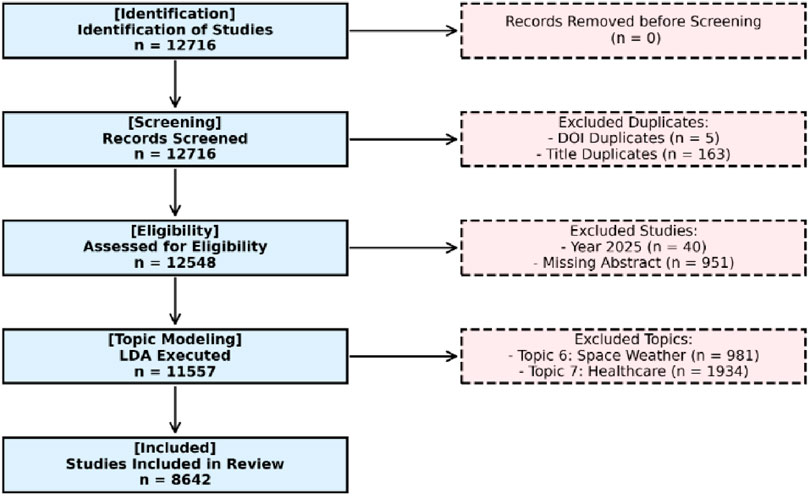
Figure 1. Preferred Reporting Items for Systematic Reviews and Meta-Analyses (PRISMA) flow diagram of data collection.

Figure 2. Topic modeling optimization validation results.
2.6 Transparency and data availability
The full article list, search strings, custom dictionaries, and topic-assignment matrices are openly available at GitHub: https://github.com/bykim1011/AI-Extreme-Weather-Review (release v1.0). The figures were generated using different tools: Figure 2 was directly from NetMiner outputs, while Figure 1 was created in Python to illustrate the screening process and Figure 3 was prepared in Excel.
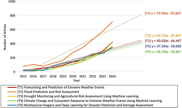
Figure 3. Time-series analysis and linear trend results by topic.
3 Results
3.1 Overview of results
This study applied LDA to analyze AI application trends in extreme-weather prediction and response from 2015 to 2024, classifying a total of 8,642 academic articles into five principal topics. Table 1 presents the main keywords for each topic alongside the frequency and proportion of articles. Frequency analysis revealed that Topic 2, Flood Prediction and Risk Assessment, had the highest share (33.83%), followed by Topic 1, Forecasting and Prediction of Extreme-Weather Events (17.79%), Topic 5, Multisource Imagery and Deep Learning for Disaster Detection and Damage Assessment (16.87%), Topic 3, Drought Monitoring and Agricultural Risk Assessment Using Machine Learning (16.35%), and Topic 4, Climate Change and Ecosystem Response to Extreme-Weather Events Using Machine Learning (15.16%). This distribution indicates that AI techniques have been particularly active in flood prediction and assessment research in recent years. The representative articles listed in Table 2 were selected through a two-step process to ensure high thematic relevance. First, all 8,642 articles were ranked in descending order by their topic-probability scores generated by the LDA model. Second, abstracts of the top-ranked articles were manually reviewed to identify five studies per topic that best exemplified its core research focus. This combined quantitative–qualitative procedure ensured that the selected articles are both statistically robust and substantively representative. To further contextualize these representative studies, additional metadata—including publication year, source, and citation counts—are provided. Figure 3 illustrates a time-series analysis of topic occurrence, visualizing annual changes in article counts for each topic over the study period (2015–2024). Topic 2 exhibited a steady upward trend from the early years and a pronounced surge after 2020. This post-2020 acceleration in Topic 2 suggests an emerging research priority, potentially driven by increasing flood events and advances in hydrological modeling. Topics 1/5 also showed continuous growth in research interest over the past 5 years, underscoring their rising importance. Meanwhile, Topics 3/4 demonstrated stable increases in recent years, confirming that AI-based precision agriculture and ecosystem management have become increasingly prominent research themes. Building on these findings, the following sections delve into the specific trends, characteristics, and key case studies for each topic. A full list of topic assignments and probabilities is available in Supplementary Table S1.
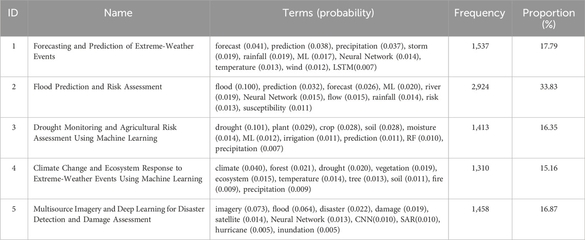
Table 1. Main keywords and article frequency and proportion by topic.

Table 2. Characteristics of five representative articles for each topic.
3.2 Topic 1: forecasting and prediction of extreme-weather events
In recent years, AI-based techniques—particularly machine learning and deep learning—have become the primary research methods in the field of extreme-weather forecasting and prediction. The main keywords—forecast, precipitation, storm, wind, temperature, LSTM—reflect the application of modeling techniques to a diverse set of meteorological variables.
Specifically, efforts to address initial-condition sensitivity through machine-learning and deep-learning approaches have increased. For example, Vonich and Hakim (2024) introduced an initial-condition optimization method using backpropagation, reducing error by over 90 percent compared to conventional models. This result underscores the critical role of initial-condition optimization in determining model performance.
Conventional AI-based models tended to underestimate extreme events as forecast lead time increased. To overcome this, the diffusion-model-based FuXi-Extreme was proposed (Zhong et al., 2024); it captures finer intensity variations in heavy rainfall and strong winds, thereby greatly alleviating the underestimation issue compared to the original FuXi.
At the same time, combining NWP and AI-based models has led to increasingly precise 2–6-week sub-seasonal forecasting. These advances promise practical integration with disaster management systems (Weyn et al., 2021). Notably, recent work has developed an XGBoost-based hurricane wind reconstruction model, demonstrating its potential application in weather disaster analysis and response systems (Yang et al., 2022).
Overall, these research trends indicate that AI technologies are enhancing the reliability of extreme-weather forecasting. Future studies are expected to focus on developing more sophisticated deep-learning architectures, quantifying and reducing forecast uncertainty, and validating system performance in operational settings. AI-based extreme-weather forecasting systems are anticipated to strengthen disaster response capabilities and substantially minimize societal losses.
3.3 Topic 2: flood prediction and risk assessment
In recent years, AI-based methods—including machine learning and deep learning—have become central research approaches in flood prediction and risk assessment. The main keywords—flood, prediction, forecast, river, flow, rainfall, risk, susceptibility—highlight the factors necessary for accurately identifying flood occurrence potential and vulnerable areas.
Susceptibility-mapping using various machine-learning models and short-to medium-term flow prediction have been particularly active. For example, Costache et al. (2023) used a fuzzy machine learning hybrid model to generate a flood-susceptibility map for the Prahova River basin in Romania, achieving high AUC (area under the curve) and accuracy and demonstrating superior performance compared to conventional models. Meanwhile, Zhou & Kang (2023) compared the flood-routing performance of several machine-learning techniques—LSTM, GRU, and random forest (RF)—for the Yangtze River basin, reporting that the GRU model exhibited the highest prediction accuracy. Huan (2024) applied a Loess-Temporal Convolutional Network (TCN)-GRU model to urban real-time flood forecasting, effectively capturing seasonal and geographic heterogeneity to improve accuracy.
Researchers have also derived flood-prone areas using RF and decision tree models (Khosravi et al., 2018; Costache et al., 2021; El Baida et al., 2024) and advanced dam outflow and monthly flow prediction by integrating optimization algorithms or statistical techniques into artificial neural network (ANN) frameworks. For instance, Zaini et al. (2018) combined the Bat algorithm with a backpropagation neural network (BPNN) to develop a Bat-BPNN model, significantly improving monthly flow prediction accuracy. Brêda et al. (2021) demonstrated that pure ANN models—without additional optimization techniques—outperformed traditional benchmarks in predicting outflows for multiple large-scale hydropower dams in Brazil.
Furthermore, RNN models such as LSTM and GRU have been introduced for short-term flow prediction, efficiently learning from time-series data and outperforming conventional ANN models (Gao et al., 2020). These hybrid modeling and optimization approaches enable more precise flood-risk analysis and suggest that either simple ANN or optimization/ensemble strategies can be effective depending on the application context (e.g., dam operations, urban flooding, large basins).
Overall, AI-based flood prediction and risk assessment has rapidly advanced to process vast meteorological, topographic, and hydrological data efficiently and improve predictive performance. Future research will likely focus on developing more sophisticated deep-learning architectures, minimizing forecast uncertainty, and implementing and validating real-time flood-warning systems to substantially strengthen disaster-response capabilities.
3.4 Topic 3: drought monitoring and agricultural risk assessment using machine learning
Driven by climate change, the importance of drought monitoring and agricultural risk assessment has increased, and data-driven approaches using machine-learning techniques have emerged as key research methodologies. Keyword analysis indicates that current studies focus on moisture-related factors directly affecting crop growth, leveraging the fusion of machine-learning methods with remote-sensing data for precision irrigation and yield prediction.
Recent trends show notable efforts to enhance drought monitoring accuracy and efficiency through the integration of remote-sensing technology and machine-learning. Suyala et al. (2024) used hyperspectral remote-sensing data to diagnose potato moisture content and develop a water-saving irrigation algorithm. Wang et al. (2024) combined Unmanned Aerial Vehicle (UAV)-based multispectral and thermal imagery to create a moisture-stress diagnosis model for winter wheat, demonstrating its potential for irrigation decision support.
Machine learning's role, has also expanded in soil-moisture prediction and agricultural risk assessment. Crusiol et al. (2023) developed a model to predict soil moisture in soybean cultivation areas using leaf-based hyperspectral reflectance, validating the effectiveness of remote-sensing-based monitoring. Akcapınar and Çakmak, (2025) combined the MODIS drought index with machine-learning algorithms to predict wheat yield, suggesting contributions to production forecasting and early-warning systems. Yang et al. (2023) demonstrated the feasibility of field-level drought and irrigation monitoring systems using high-resolution soil-moisture data generated by machine learning, highlighting practical agricultural management applications.
Although earlier research relied mainly on regression and statistical methods, recent analyses have actively adopted a variety of machine-learning models—RF, support vector machine (SVM), and ANN. Okyere et al. (2024) combined a novel drought index with machine-learning models to accurately detect drought stress in wheat. Shi et al. (2022) improved moisture-status prediction for winter wheat by fusing multisource sensor data with machine learning. Garriga et al. (2021) used hyperspectral canopy reflectance data and multiple linear regression to estimate carbon-isotope discrimination and yield in wheat, demonstrating that machine learning can greatly enhance analytical precision and efficiency.
These trends clearly show that the fusion of machine-learning and remote-sensing technologies is accelerating advances in drought monitoring and agricultural risk assessment. Future work will likely focus on developing universal models applicable across diverse crops, regions, and environmental conditions; building real-time drought-monitoring systems; and strengthening integration with agricultural decision-support platforms. AI-based drought prediction and agricultural risk assessment systems are expected to play a vital role in stabilizing crop productivity and promoting sustainable agriculture in the era of climate change.
3.5 Topic 4: climate change and ecosystem response to extreme-weather events using machine learning
In recent years, climate change has increased the frequency of extreme-weather events—droughts, heatwaves, and erratic precipitation—causing significant transformations across global ecosystems, particularly forests, grasslands, and wetlands. For example, Huang B. et al. (2024) reported that simultaneous drought and heatwave events in temperate semi-arid grasslands dramatically reduced ecosystem resistance, and You et al. (2023) identified a threshold in Inner Mongolia grasslands at which prolonged drought shifted the system from a carbon sink to a carbon source. These findings highlight how climate change impacts on ecosystem structure and function—such as vegetation productivity, soil nitrogen and carbon storage, and biodiversity—are becoming increasingly pronounced.
Recent studies have noted that combined stressors—moisture stress, heat stress, and wetland salinization—can produce asymmetric alterations in biogeochemical cycles. Chamberlain et al. (2020) found that wetland salinization sharply decreases plant photosynthesis while only modestly reducing methane (CH4) emissions, resulting in complex net greenhouse-gas outcomes. Likewise, Li et al. (2021) and Liu et al. (2023) used machine-learning techniques, including SVM and Gradient Boosted Regression Trees (GBRT), to quantify the effects of precipitation imbalance and increased extreme-drought frequency on productivity and water-use efficiency in temperate grasslands and California rangelands, respectively.
Crucially, ecosystem responses to extreme weather vary markedly across spatial and temporal contexts. Zeng et al. (2023) showed that Tibetan Plateau grasslands in regions with higher precipitation exhibit greater sensitivity to temperature increases, revealing regional vulnerability differences. Case studies such as the rapid habitat contraction of Australia’s greater glider—an arboreal marsupial (Wagner et al., 2020)—and the potential savannization of tropical rainforests (Nath et al., 2024) suggest that certain species and ecosystems may be unable to adapt to extreme conditions and could face rapid decline.
Consequently, the body of research systematically analyzing how climate change and extreme events affect ecosystem productivity, water-carbon-nitrogen cycling, and habitat conservation is expanding, and the integration of AI with ecological models is playing a pivotal role. Future work should develop integrated models that combine regional climate scenarios with long-term observational datasets to capture these complex interactions in greater detail, providing the scientific basis for strategies aimed at strengthening ecosystem resilience and sustainable resource management.
3.6 Topic 5: multisource imagery and deep learning for disaster detection and damage assessment
Research in disaster detection and damage assessment has increasingly combined multisource imagery—synthetic aperture radar (SAR), electro-optical (EO) satellite data, UAV and ground-camera images—with deep-learning techniques to automate precise detection of floods, building damage, and water-depth estimation. The main keywords—SAR, convolutional neural networks (CNNs), inundation—reflect the trend toward integrating multi-resolution, multi-sensor data to enhance disaster-response capabilities.
In flood-inundation and water-depth detection, SAR-based deep-learning models have been particularly prominent. Multi-scale Deeplab (Wu et al., 2022), Flood Water Body Extraction Network (FWENet; Wang et al., 2022), and WaterDetectionNet (Huang Y. et al., 2024) leverage CNN architectures to achieve high-accuracy mapping of inundation extents. Akiva et al. (2021) introduced H2O-Net, a self-supervised method that overcomes domain gaps between low-resolution satellite and high-resolution aerial imagery, enabling rapid and precise disaster-scene analysis.
Building-damage detection has focused on pre- and post-event satellite comparisons. Shen et al. (2022) developed BDANet, a CNN-based model for estimating building damage severity, while Kaur et al. (2023) used a hierarchical transformer architecture to perform fine-grained damage assessment over large areas. Qing et al. (2023) applied a dual distortion-adaptive generative adversarial network (GAN) to accurately transform SAR ↔ EO imagery, correcting geometric distortions in high-resolution disaster analyses.
UAV and ground-camera imagery studies also deserve attention. FloodNet (Rahnemoonfar et al., 2021) built a high-resolution aerial dataset for identifying flooded structures and roads, and Song and Tuo (2021) proposed a low-cost, real-time system for estimating flood depth from traffic-sign images. These approaches complement satellite limitations in spatial and temporal resolution, offering refined urban-flood monitoring.
Finally, a Sentinel-1 CNN benchmark (Bereczky et al., 2022) demonstrated that deep-learning methods far outperform traditional rule-based chains in water and flood mapping, automating critical hydrological information extraction and substantially reducing decision-making time in emergencies.
Overall, the fusion of multisource imagery and cutting-edge deep-learning techniques (CNNs, transformers, GANs) enables near-real-time analysis and monitoring of disaster scenes, efficiently supporting rescue and recovery decisions and minimizing damage. Future work will likely advance real-time multi-sensor, multi-resolution data processing and tighter integration with operational disaster-management systems, playing a key role in strengthening societal safety nets.
4 Discussion
4.1 Principal research themes
This study comprehensively analyzed AI application trends in extreme-weather prediction and response from 2015 to 2024 using topic modeling.
First, advanced deep-learning methods—such as LSTM and diffusion models—have substantially improved forecast accuracy for typhoon tracks, rainfall, and heatwaves. The FuXi-Extreme diffusion model, in particular, effectively addresses underestimation of extreme precipitation and wind speeds, while NWP-AI fusion approaches deliver competitive performance at 2–6-week sub-seasonal forecasting.
Second, in flood prediction and risk assessment, GRU-based flow models and fuzzy machine learning hybrid model, techniques have enhanced the reliability of real-time warning systems. A variety of machine-learning models that integrate meteorological, hydrological, and topographic data enable finer-scale flood-risk analyses.
Third, drought monitoring and agricultural risk assessment research has leveraged hyperspectral remote sensing, UAV imagery, and machine-learning (e.g., ML-HRSM) to support moisture-status diagnostics, precision irrigation, and yield prediction at 30 m resolution.
Fourth, machine-learning models such as SVM and GBRT have been used to quantify how altered precipitation patterns and extreme drought impact ecosystem productivity, carbon cycling, and habitat conservation—providing critical evidence for informed policy decisions.
Finally, the fusion of multisource imagery (SAR, EO, UAV, ground cameras) with state-of-the-art deep-learning models (CNNs, transformers, GANs) is automating high-resolution mapping of flood extents and building damage, thereby accelerating emergency response and recovery efforts.
4.2 Broader implications and context
Interestingly, despite being included as a search keyword, heatwave did not emerge as an independent topic in the LDA solution. This suggests that heatwave-related research is often treated as a sub-theme within broader domains, rather than forming a distinct, high-frequency cluster. This interpretation is strongly supported by a quantitative post hoc check: among the 8,642 articles, 59 contain “heatwave” in their title, and 58 of these (98.3%) are classified under either Topic 1 (Forecasting and prediction) or Topic 4 (Ecosystem response). While this finding underscores the interdisciplinary nature of heatwave research, it also represents a limitation of the present topic modeling approach. Future studies could apply targeted search strategies or sub-topic modeling to better isolate heatwave-related AI applications—for example, focusing specifically on urban heatwaves (where AI-driven microclimate models address heat–health risks) or compound extremes such as heatwave–drought interactions (where AI can improve multi-hazard early warning systems).
In parallel, previous narrative and qualitative reviews have provided valuable overviews of AI/ML applications in specific extreme weather contexts but often lack quantitative mapping of thematic prevalence and temporal evolution. For example, McGovern et al. (2023) synthesized applications for high-impact phenomena such as lightning, hail, tornadoes, and severe winds, emphasizing model architectures and forecasting challenges. While informative, such approaches do not measure the relative weight of different research themes or capture how their prominence changes over time. By contrast, our LDA-based, data-driven analysis quantifies thematic composition across the field—revealing, for instance, that flood-related studies (Topic 2) constitute 33.83% of the literature—and identifies dynamic patterns, including a pronounced post-2020 surge in flood-focused research. This integrative perspective not only corroborates qualitative insights but also embeds them within a broader, empirically grounded thematic and temporal framework, thereby extending the scope and interpretive power of prior reviews.
Beyond heatwaves, the policy and operational implications of our findings extend to other hazards as well. For instance, AI has already been incorporated into flash flood early-warning systems in China, which manage real-time data across multiple administrative levels to support rapid decision-making (Liu et al., 2018). In addition, hybrid and ensemble machine learning models for flood depth estimation have demonstrated improved predictive accuracy, directly supporting flood prevention and relief planning (Liu et al., 2025). On the agricultural front, AI-enabled precision irrigation frameworks—such as hybrid deep-learning models that combine remote sensing with temporal dependencies—have shown strong potential to optimize water use and strengthen food security under climate variability (Ye et al., 2024). These cases illustrate how the methodological advances documented in this review can translate into tangible risk-reduction strategies and smart resource management, underscoring the importance of integrating AI research outputs into policy frameworks and real-world disaster management operations.
Collectively, these findings confirm that AI technologies can complement traditional physics-based forecasting, deliver more precise predictions of extreme events, and integrate with real-time disaster-response systems to minimize social and economic losses. They also underscore the necessity of multidisciplinary, sensor-fusion approaches for next-generation disaster-management systems.
4.3 Limitations and future directions
Nonetheless, this analysis is constrained by its reliance on English-language abstracts indexed in the Web of Science database—potentially excluding the most recent studies and relevant grey literature—and by the subjective interpretation inherent in topic-model outputs. Future research should expand coverage to a broader range of data sources and real-world case studies, rigorously quantify and reduce AI-model uncertainty, and validate system performance in operational settings. Such efforts would help standardize and disseminate AI-based forecasting and disaster-response technologies while fostering stronger international collaborations.
In addition, as with most topic-modeling approaches, the results are inherently sensitive to preprocessing choices (e.g., tokenization, stop-word selection) and corpus composition, meaning that alternative parameter settings may yield slightly different topic structures. Acknowledging this limitation underscores the importance of transparency in model design and the value of complementary qualitative validation when interpreting thematic outputs.
Taken together, these insights highlight both the promise and the challenges of applying AI to extreme-weather prediction and response, offering a foundation for more robust, transparent, and operationally relevant research in the years ahead.
5 Conclusion
This systematic topic-model review shows that artificial intelligence research has rapidly diversified across all major extreme-weather hazards since 2015. Deep-learning families—LSTM, diffusion and NWP-AI fusion—now outperform traditional statistical baselines for typhoon tracks, high-intensity rainfall and sub-seasonal heatwave forecasts, while GRU-based flow models and fuzzy-ML hybrids already enhance real-time flood-warning reliability. In drought monitoring, hyperspectral and UAV imagery combined with ML-HRSM enable 30 m-scale moisture diagnostics and precision irrigation; for ecological drought impacts, SVM and GBRT quantify effects on productivity, carbon cycling and habitat resilience. Multisource image fusion with CNNs, transformers and GANs automates fine-resolution mapping of flood extent and building damage, accelerating emergency response and recovery. Collectively, these advances confirm that AI can complement physics-based forecasting, integrate with sensor networks and disaster-response workflows, and thereby help to reduce social and economic losses from extremes.
At the same time, this study is limited by its reliance on English-language abstracts indexed in the Web of Science—potentially excluding grey literature and non-English research—and by the subjective interpretation inherent in topic-model outputs. Looking ahead, future work should broaden data sources, incorporate diverse case studies, and embed uncertainty quantification and field validation into next-generation AI early-warning systems. More importantly, the field must now shift from methodological development to operational integration by embedding AI pipelines within meteorological services and standardizing evaluation protocols. Linking predictive outputs with disaster-management agencies will enable proactive planning, resource allocation, and cross-border coordination, thereby providing not only methodological refinements but also a practical blueprint for embedding AI into real-world extreme-weather forecasting and climate-resilience policy.
Data availability statement
All search strings, article lists, dictionaries, and topic assignment matrices are openly available at GitHub (https://github.com/bykim1011/AI-Extreme-Weather-Review, release v1.0). An archived snapshot is preserved at Zenodo (https://doi.org/10.5281/zenodo.15515285). No new primary observational data were generated for this study. The repository links and accession information can also be found in the article and Supplementary Material.
Author contributions
BK: Conceptualization, Data curation, Formal Analysis, Investigation, Methodology, Visualization, Writing – original draft, Writing – review and editing. TK: Methodology, Supervision, Validation, Writing – review and editing.
Funding
The author(s) declare that financial support was received for the research and/or publication of this article. This work was funded by the Korea Meteorological Administration Research and Development Program “Developing Intelligent Assistant Technology and Its Application for Weather Forecasting Process” under Grant (KMA 2021-00123).
Conflict of interest
The authors declare that the research was conducted in the absence of any commercial or financial relationships that could be construed as a potential conflict of interest.
Generative AI statement
The author(s) declare that no Generative AI was used in the creation of this manuscript.
Any alternative text (alt text) provided alongside figures in this article has been generated by Frontiers with the support of artificial intelligence and reasonable efforts have been made to ensure accuracy, including review by the authors wherever possible. If you identify any issues, please contact us.
Publisher’s note
All claims expressed in this article are solely those of the authors and do not necessarily represent those of their affiliated organizations, or those of the publisher, the editors and the reviewers. Any product that may be evaluated in this article, or claim that may be made by its manufacturer, is not guaranteed or endorsed by the publisher.
Supplementary material
The Supplementary Material for this article can be found online at: https://www.frontiersin.org/articles/10.3389/fenvs.2025.1659344/full#supplementary-material
References
Akcapınar, M. C., and Çakmak, B. (2025). Yield prediction models for some wheat varieties with satellite-based drought indices and machine learning algorithms. Irrigation Drainage 74, 237–250. doi:10.1002/ird.2989
Akiva, P., Purri, M., Dana, K., Tellman, B., and Anderson, T. (2021). “H2O-Net: self-Supervised flood segmentation via adversarial domain adaptation and label refinement,” in 2021 IEEE Winter conference on applications of computer vision (WACV), (Waikoloa, HI, USA: IEEE), 111–122. doi:10.1109/WACV48630.2021.00016
Bereczky, M., Wieland, M., Krullikowski, C., Martinis, S., and Plank, S. (2022). Sentinel-1-Based water and flood mapping: benchmarking convolutional neural networks against an operational rule-based processing chain. IEEE J. Sel. Top. Appl. Earth Obs. Remote Sens. 15, 2023–2036. doi:10.1109/JSTARS.2022.3152127
Blei, D. M., Ng, A. Y., and Jordan, M. I. (2003). Latent dirichlet allocation. J. Mach. Learn. Res. 3, 993–1022. Available online at: http://www.jmlr.org/papers/v3/blei03a.html.
Brêda, J. P. L. F., Paiva, R. C. D. D., Pedrollo, O. C., Passaia, O. A., and Collischonn, W. (2021). Modeling coordinated operation of multiple hydropower reservoirs at a continental scale using artificial neural network: the case of Brazilian hydropower system. RBRH 26, e12. doi:10.1590/2318-0331.262120210011
Chamberlain, S. D., Hemes, K. S., Eichelmann, E., Szutu, D. J., Verfaillie, J. G., and Baldocchi, D. D. (2020). Effect of drought-induced salinization on wetland methane emissions, gross ecosystem productivity, and their interactions. Ecosystems 23, 675–688. doi:10.1007/s10021-019-00430-5
Costache, R., Arabameri, A., Elkhrachy, I., Ghorbanzadeh, O., and Pham, Q. B. (2021). Detection of areas prone to flood risk using state-of-the-art machine learning models. Geomatics, Nat. Hazards Risk 12, 1488–1507. doi:10.1080/19475705.2021.1920480
Costache, R., Abdo, H. G., Pratap Mishra, A., Pal, S. C., Islam, A. R.Md. T., Pande, C. B., et al. (2023). Using fuzzy and machine learning iterative optimized models to generate the flood susceptibility maps: case study of Prahova River basin, Romania. Geomatics, Nat. Hazards Risk 14, 2281241. doi:10.1080/19475705.2023.2281241
Crusiol, L. G. T., Nanni, M. R., Furlanetto, R. H., Sibaldelli, R. N. R., Sun, L., Gonçalves, S. L., et al. (2023). Assessing the sensitive spectral bands for soybean water status monitoring and soil moisture prediction using leaf-based hyperspectral reflectance. Agric. Water Manag. 277, 108089. doi:10.1016/j.agwat.2022.108089
El Baida, M., Boushaba, F., Chourak, M., Hosni, M., Sabar, H., and Zahaf, T. (2024). Flood risk decomposed: optimized machine learning hazard mapping and multi-criteria vulnerability analysis in the city of Zaio, Morocco. J. Afr. Earth Sci. 220, 105431. doi:10.1016/j.jafrearsci.2024.105431
Gao, S., Huang, Y., Zhang, S., Han, J., Wang, G., Zhang, M., et al. (2020). Short-term runoff prediction with GRU and LSTM networks without requiring time step optimization during sample generation. J. Hydrology 589, 125188. doi:10.1016/j.jhydrol.2020.125188
Garriga, M., Romero-Bravo, S., Estrada, F., Méndez-Espinoza, A. M., González-Martínez, L., Matus, I. A., et al. (2021). Estimating carbon isotope discrimination and grain yield of bread wheat grown under water-limited and full irrigation conditions by hyperspectral canopy reflectance and multilinear regression analysis. Int. J. Remote Sens. 42, 2848–2871. doi:10.1080/01431161.2020.1854888
Huan, S. (2024). Geographic heterogeneity of activation functions in urban real-time flood forecasting: based on seasonal trend decomposition using Loess-Temporal Convolutional Network-Gated Recurrent Unit model. J. Hydrology 636, 131279. doi:10.1016/j.jhydrol.2024.131279
Huang, B., Li, P., Lu, H., Yin, J., Li, Z., and Wang, H. (2024a). WaterDetectionNet: a new deep learning method for flood mapping with SAR image convolutional neural network. IEEE J. Sel. Top. Appl. Earth Obs. Remote Sens. 17, 14471–14485. doi:10.1109/JSTARS.2024.3440995
Huang, Y., Lei, H., and Duan, L. (2024b). Resistance of grassland productivity to drought and heatwave over a temperate semi-arid climate zone. Sci. Total Environ. 951, 175495. doi:10.1016/j.scitotenv.2024.175495
Intergovernmental Panel On Climate Change (Ipcc) (2023). Climate change 2021 – the Physical Science basis: Working group I contribution to the sixth assessment report of the intergovernmental panel on climate change. 1st Edn. Cambridge University Press. doi:10.1017/9781009157896
Jacobi, C., Van Atteveldt, W., and Welbers, K. (2016). Quantitative analysis of large amounts of journalistic texts using topic modelling. Digit. Journal. 4, 89–106. doi:10.1080/21670811.2015.1093271
Kaur, N., Lee, C., Mostafavi, A., and Mahdavi-Amiri, A. (2023). Large-scale building damage assessment using a novel hierarchical transformer architecture on satellite images. Comput. aided Civ. Eng. 38, 2072–2091. doi:10.1111/mice.12981
Khosravi, K., Pham, B. T., Chapi, K., Shirzadi, A., Shahabi, H., Revhaug, I., et al. (2018). A comparative assessment of decision trees algorithms for flash flood susceptibility modeling at Haraz watershed, northern Iran. Sci. Total Environ. 627, 744–755. doi:10.1016/j.scitotenv.2018.01.266
Li, Z., Chen, C., Nevins, A., Pirtle, T., and Cui, S. (2021). Assessing and modeling ecosystem carbon exchange and water vapor flux of a pasture ecosystem in the temperate climate-transition Zone. Agronomy 11, 2071. doi:10.3390/agronomy11102071
Liu, C., Guo, L., Ye, L., Zhang, S., Zhao, Y., and Song, T. (2018). A review of advances in China’s flash flood early-warning system. Nat. Hazards 92, 619–634. doi:10.1007/s11069-018-3173-7
Liu, H., Jin, Y., Roche, L. M., O’Geen, A. T., and Dahlgren, R. A. (2023). Regional differences in the response of California’s rangeland production to climate and future projection. Environ. Res. Lett. 18, 014011. doi:10.1088/1748-9326/aca689
Liu, B., Li, Y., Ma, M., and Mao, B. (2025). A comprehensive review of machine learning approaches for flood depth estimation. Int. J. Disaster Risk Sci. 16, 433–445. doi:10.1007/s13753-025-00639-0
McGovern, A., Chase, R. J., Flora, M., Gagne, D. J., Lagerquist, R., Potvin, C. K., et al. (2023). A review of machine learning for convective weather. Artif. Intell. Earth Syst. 2, e220077. doi:10.1175/AIES-D-22-0077.1
Nath, D., Nath, R., and Chen, W. (2024). Faster dieback of rainforests altering tropical carbon sinks under climate change. npj Clim. Atmos. Sci. 7, 235. doi:10.1038/s41612-024-00793-0
Okyere, F. G., Cudjoe, D. K., Virlet, N., Castle, M., Riche, A. B., Greche, L., et al. (2024). Hyperspectral imaging for phenotyping plant drought stress and nitrogen interactions using multivariate modeling and machine learning techniques in wheat. Remote Sens. 16, 3446. doi:10.3390/rs16183446
Qing, Y., Zhu, J., Feng, H., Liu, W., and Wen, B. (2023). Two-Way generation of high-resolution EO and SAR images via dual distortion-adaptive GANs. Remote Sens. 15, 1878. doi:10.3390/rs15071878
Rahnemoonfar, M., Chowdhury, T., Sarkar, A., Varshney, D., Yari, M., and Murphy, R. R. (2021). FloodNet: a high resolution aerial imagery dataset for post flood scene understanding. IEEE Access 9, 89644–89654. doi:10.1109/ACCESS.2021.3090981
Shen, Y., Zhu, S., Yang, T., Chen, C., Pan, D., Chen, J., et al. (2022). BDANet: multiscale convolutional neural network with cross-directional attention for building damage assessment from satellite images. IEEE Trans. Geosci. Remote Sens. 60, 1–14. doi:10.1109/TGRS.2021.3080580
Shi, B., Yuan, Y., Zhuang, T., Xu, X., Schmidhalter, U., Ata-Ui-Karim, S. T., et al. (2022). Improving water status prediction of winter wheat using multi-source data with machine learning. Eur. J. Agron. 139, 126548. doi:10.1016/j.eja.2022.126548
Song, Z., and Tuo, Y. (2021). Automated flood depth estimates from online traffic sign images: explorations of a convolutional neural network-based method. Sensors 21, 5614. doi:10.3390/s21165614
Suyala, Q., Li, Z., Zhang, Z., Jia, L., Fan, M., Sun, Y., et al. (2024). Developing a hyperspectral remote sensing-based Algorithm to diagnose potato moisture for water-saving irrigation. Horticulturae 10, 811. doi:10.3390/horticulturae10080811
Vonich, P. T., and Hakim, G. J. (2024). Predictability limit of the 2021 Pacific Northwest heatwave from deep-learning sensitivity analysis. Geophys. Res. Lett. 51, e2024GL110651. doi:10.1029/2024GL110651
Wagner, B., Baker, P. J., Stewart, S. B., Lumsden, L. F., Nelson, J. L., Cripps, J. K., et al. (2020). Climate change drives habitat contraction of a nocturnal arboreal marsupial at its physiological limits. Ecosphere 11, e03262. doi:10.1002/ecs2.3262
Wang, J., Wang, S., Wang, F., Zhou, Y., Wang, Z., Ji, J., et al. (2022). FWENet: a deep convolutional neural network for flood water body extraction based on SAR images. Int. J. Digital Earth 15, 345–361. doi:10.1080/17538947.2021.1995513
Wang, J., Lou, Y., Wang, W., Liu, S., Zhang, H., Hui, X., et al. (2024). A robust model for diagnosing water stress of winter wheat by combining UAV multispectral and thermal remote sensing. Agric. Water Manag. 291, 108616. doi:10.1016/j.agwat.2023.108616
Weyn, J. A., Durran, D. R., Caruana, R., and Cresswell-Clay, N. (2021). Sub-Seasonal forecasting with a large ensemble of deep-learning weather prediction models. J. Adv. Model Earth Syst. 13, e2021MS002502. doi:10.1029/2021MS002502
Wu, H., Song, H., Huang, J., Zhong, H., Zhan, R., Teng, X., et al. (2022). Flood detection in dual-polarization SAR images based on multi-scale deeplab model. Remote Sens. 14, 5181. doi:10.3390/rs14205181
Xu, J., Wang, Y., and Yang, C. (2023). Quantifying the environmental effects on tropical cyclone intensity change using a simple dynamically based dynamical system model. J. Atmos. Sci. 80, 2897–2913. doi:10.1175/JAS-D-23-0058.1
Yang, Q., Lee, C.-Y., Tippett, M. K., Chavas, D. R., and Knutson, T. R. (2022). Machine learning–based hurricane wind reconstruction. Weather Forecast. 37, 477–493. doi:10.1175/WAF-D-21-0077.1
Yang, Z., Huang, J., and Zhang, Z. (2023). “Toward field level drought and irrigation monitoring using machine learning based high-resolution soil moisture (ML-HRSM) data,” in Igarss 2023 - 2023 IEEE international geoscience and remote sensing symposium (Pasadena, CA, USA), 3570–3573. doi:10.1109/IGARSS52108.2023.10283282
Ye, Z., Yin, S., Cao, Y., and Wang, Y. (2024). AI-driven optimization of agricultural water management for enhanced sustainability. Sci. Rep. 14, 25721. doi:10.1038/s41598-024-76915-8
You, C., Wang, Y., Tan, X., Cui, E., Zhang, B., Bian, C., et al. (2023). Inner Mongolia grasslands act as a weak regional carbon sink: a new estimation based on upscaling eddy covariance observations. Agric. For. Meteorology 342, 109719. doi:10.1016/j.agrformet.2023.109719
Zaini, N., Malek, M. A., Yusoff, M., Osmi, S. F. C., Mardi, N. H., and Norhisham, S. (2018). Bat algorithm and neural network for monthly streamflow prediction. Ho Chi Minh, Vietnam 2030, 020260. doi:10.1063/1.5066901
Zeng, N., Ren, X., He, H., Zhang, L., and Niu, Z. (2023). Precipitation conditions constrain the sensitivity of aboveground net primary productivity in Tibetan Plateau grasslands to climate change. Remote Sens. 15, 2591. doi:10.3390/rs15102591
Zhong, X., Chen, L., Liu, J., Lin, C., Qi, Y., and Li, H. (2024). FuXi-Extreme: improving extreme rainfall and wind forecasts with diffusion model. Sci. China Earth Sci. 67, 3696–3708. doi:10.1007/s11430-023-1427-x
Keywords: extreme weather events, artificial intelligence, machine learning, deep learning, topic modeling
Citation: Kim B and Kim T (2025) AI in extreme weather events prediction and response: a systematic topic-model review (2015–2024). Front. Environ. Sci. 13:1659344. doi: 10.3389/fenvs.2025.1659344
Received: 11 July 2025; Accepted: 28 August 2025;
Published: 18 September 2025.
Edited by:
Chia-Jeng Chen, National Chung Hsing University, TaiwanReviewed by:
Wen-Ping Tsai, National Cheng Kung University, TaiwanChengChia Huang, Feng Chia University, Taiwan
Copyright © 2025 Kim and Kim. This is an open-access article distributed under the terms of the Creative Commons Attribution License (CC BY). The use, distribution or reproduction in other forums is permitted, provided the original author(s) and the copyright owner(s) are credited and that the original publication in this journal is cited, in accordance with accepted academic practice. No use, distribution or reproduction is permitted which does not comply with these terms.
*Correspondence: Byeongyeon Kim, YnlraW0xMDExQGtvcmVhLmty