 Yamikani Harry Makwinja
 Patrick John O’Farrell2,4
 Jude Ndzifon Kimengsi
- 1Forest Institutions and International Development Research Group (FIID), Chair of Tropical and International Forestry, Technische Universität Dresden, Dresden, Saxony, Germany
- 2Institute for Integrated Management of Material Fluxes and of Resources, United Nations University Dresden, Saxony, Germany
- 3Department of Forestry, Ministry of Natural Resources and Climate Change, Blantyre, Malawi
- 4Department of Biodiversity and Conservation Biology, Faculty of Natural Science, University of Western Cape, Cape Town, South Africa
- 5Department of Geography, The University of Bamenda, Bambili, Cameroon
Landscapes in southern Africa are subjected to significant dynamics related to Land Cover Change (LCC). While there is abundant research on Land Cover Trajectories (LCT), more comprehensive studies are still needed to determine the extent to which these changes reshape the Water-Energy-Food-Climate (WEFC) Nexus. We employed an explanatory sequential mixed-methods approach in Malawi using Case studies of Blantyre and Lilongwe districts to 1 explore trends in LCC from 1994 to 2024, and 2 analyse the effects of land cover trends on the WEFC Nexus. This approach involved conducting a quantitative analysis of Landsat images using ArcGIS software to determine the LCC and applying the Mann-Kendall statistical analysis test to identify trends in key land cover classes and associated resources. Qualitative data were gathered using ethnographic techniques, focus group discussions, key informant interviews, and expert interviews. These were analysed through deductive content analysis to provide complementary evidence. The analysis reveals 1 a dynamic land cover transformation characterised by a significant decline in forest cover, cropland expansion, and urbanisation. 2 LCC directions that weaken WEFC Nexus. Declining water productivity and increasing water stress are diminishing hydropower generation capacity and degrading ecosystem integrity, thereby threatening regional water and energy security. Concurrently, agricultural intensification has failed to ameliorate food insecurity within local communities. The study reveals significant inefficiencies in resource allocation and reflects profound underlying socioeconomic disparities. It offers valuable theoretical and policy implications for the Resource Nexus in southern Africa. It also highlights the significance of the WEFC Nexus in Malawi and serves as a pertinent example for other southern African nations facing similar challenges. It advocates for ongoing research and adaptive management strategies to address the interdependencies of these resources, supporting Nature-positive sustainable development and enhancing resilience against socio-environmental changes.
1 Introduction
Land cover dynamics in Southern Africa represent a critical driver of socio-environmental change. It is fundamentally altering the region’s ecological and socioeconomic fabric (Martin et al., 2022). Over the past five decades, the conversion of natural forests, grasslands, and savannas to agricultural and urban areas has created complex trade-offs (IPBES, 2018). While this expansion has increased food production, it has also led to declines in water and energy security, intensified biodiversity loss (Fischer et al., 2023), and increased pollution (Nelson et al., 2021). These changes highlight the water-energy-food-climate (WEFC) Nexus, where gains in one sector often come at the expense of others, thereby complicating resource management (Herrera-Franco et al., 2023).
Land cover changes (LCC) have profound bio-geophysical consequences that disrupt the Earth’s surface energy balance and destabilise critical biogeochemical cycles (IPBES, 2018; Herrera-Franco et al., 2023). These alterations not only amplify vulnerabilities to climate change but also intensify the frequency and severity of extreme events (Callahan, 2025). Consequently, the degradation of essential ecosystem services erodes the planet’s natural infrastructure (Pascual et al., 2023), which is fundamental for building community resilience in the face of extreme ecological events such as disasters and pandemics (Seddon et al., 2021).
Despite international efforts, such as the UN Decade on Ecosystem Restoration, the African Forest Landscape Restoration Initiative (AFR100), and a scientific consensus on the negative impacts of land cover change on carbon sequestration and habitat integrity (Strassburg et al., 2020), global land-use patterns continue to trend toward degradation (Herrera-Franco et al., 2023). This highlights an “implementation gap” between ambitious restoration goals and practical realities, suggesting an urgent need for more nuanced research and policies that balance agricultural needs with ecosystem preservation (Seddon et al., 2021; Strassburg et al., 2020). Between 1960 and 2019, approximately 4.3 billion hectares of land transitioned annually, resulting in a net forest loss of 80 million hectares, offset by a 1.0 billion hectares increase in cropland and a 90 million hectares rise in pasture (Winkler et al., 2021). A clear North-South divide is evident: forest cover has increased in the Global North while deforestation continues in the Global South (Bryan et al., 2018).
Southern Africa faces significant deforestation linked to food production demands and external pressures, particularly from resource extraction. Forest cover in temperate regions is increasing, while tropical areas lose approximately 12 million hectares annually, primarily due to agricultural expansion for crops such as sugarcane and oil palm (Austin et al., 2019). Urbanisation and agricultural expansion are connected to environmental degradation and the overexploitation of resources, which retards resource nexus potential for diverse values of nature (Figure 1) (Makwinja and Mkhwimba, 2025).
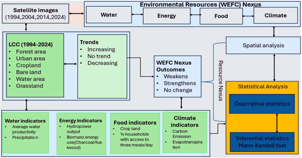
Figure 1. Analytical framework of the study adapted from FAO (2020) and Brouwer et al. (2023).
This study highlights a case study from Malawi, a country in the southern African region, where the LCC is rapidly developing, with cities and agricultural areas expanding into natural areas. Environmental resources are being overexploited and degraded (O'Farrell et al., 2009; Hutchings et al., 2022; Gambe et al., 2023). According to Xiao et al. (2022), at least 30% of the top 20 countries in Africa with significant LCC are in Southern Africa. For example, Malawi (Gondwe et al., 2019), Zimbabwe (Masolele et al., 2024), and Zambia (Phiri et al., 2019) have lost an average of more than a quarter of their forests to agriculture, bare land and settlements, respectively, in 20 years between 2000 and 2020. In Malawi, significant changes in LULC have been documented in various studies (Bone et al., 2016; Gondwe et al., 2019). An earlier study in southern Malawi indicated an increase in built-up areas and a decrease in bare soil, forestland, and grassland over the past three decades (Mawenda et al., 2020).
However, the extent to which these changes affect the patterns and outcomes of the Water-Energy-Food-Climate (WEFC) nexus remains an unaddressed issue. Recent studies of LULC change in the Upper Shire River and the Elephant Marsh in Malawi reported approximately 12% forest loss (2001–2022), which is subsequently weakening ecosystem services vital for biodiversity and community livelihoods (Ngwira and Watanabe, 2019).
The loss of forest cover is primarily attributed to several anthropogenic drivers, including agricultural expansion, population growth, and the demand for firewood, which have contributed significantly to the observed deforestation rates in Malawi (Ngwira and Watanabe, 2019). The implications of this deforestation are profound, as it threatens the ecosystem services that forests provide, including water regulation, carbon sequestration, and habitat preservation (LeBrasseur, R. (2022). Notably, forests play a crucial role in maintaining local water cycles and supporting hydropower production, which is vital for Malawi’s economy. The hydrological dynamics in the Lake Malawi and Shire River Basin exhibit increasing vulnerability to climate change, with projected reductions in river flows exacerbating the challenges facing water resources and energy generation in the region (Bhave et al., 2022). Such changes are increasing sediment loads and reducing hydropower efficiency at Kapichira and Nkula power stations (Kapute Mzuza et al., 2019). These trends illustrate a predominance of an agro-mosaic landscape driven by urban expansion and agricultural intensification, which are shaping the country’s biophysical conditions.
Understanding these dynamics is crucial for developing cohesive policy frameworks, which have historically lacked coordination across different sectors (Kimengsi et al., 2022). By recognising the interactions among these systems, stakeholders can create integrated management strategies that enhance resilience against climate change, particularly in communities that heavily rely on natural resources (Mabhaudhi et al., 2018; Jørstad and Webersik, 2016; Brouwer et al., 2023; Sannou and Guenther, 2025). The study, therefore, uses case studies of Blantyre and Lilongwe Districts from 1994 to 2024 to contribute answers to two key questions: 1 What are the key trends of LCC? and 2 How do these trends affect the WEFC nexus? The findings are essential in informing sustainable resource planning in alignment with global transformations in the Anthropocene era.
2 Materials and methods
2.1 Description of the study area
Malawi, a landlocked country in southeastern Africa, spans 118,484 km2 and shares borders with Mozambique, Tanzania, and Zambia (Figure 2). It has a population of approximately 21.7 million, with a growth rate of 2.6% (National Planning Commission, 2020). The country experiences distinct wet and dry seasons, predominantly covered by Miombo woodland. Approximately 85% of the population relies on rain-fed agriculture, fisheries, and forestry, with a GDP of $10.84 billion (National Statistical Office, 2018). Biomass fuels account for 86% of energy consumption (Government of Malawi, 2023).
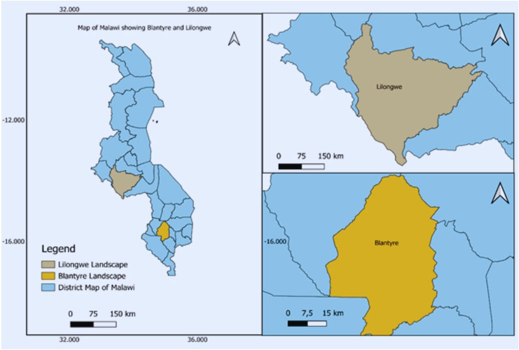
Figure 2. Map of Malawi showing Blantyre and Lilongwe districts.
Blantyre and Lilongwe Districts are key case studies for understanding LCC trends and their implications for the WEFC Nexus in Southern Africa. These districts reflect diverse socio-economic conditions and environmental challenges, showcasing the interactions between urban and peri-urban communities. High urban population densities create resource stress, while peri-urban areas rely on agricultural outputs that are closely linked to water, climate, and energy.
2.2 Data collection
2.2.1 Spatial dataset
Geospatial data on land cover change was sourced from the USGS Earth Explorer website for the period 1994 to 2024. This source was chosen for several reasons: it offers extensive historical data, high spectral resolution (7–11 bands), medium to high spatial resolutions (15–30 m/pixel), is open access and free, has low cloud cover (less than 5%), and provides complete coverage of the study area without missing scenes. Landsat composite images from 1994, 2004, 2014, and 2024, with minimal cloud cover, were collected for Blantyre and Lilongwe.
2.2.2 Data classification
The classification included imagery from both wet (December-April) and dry seasons (May-November). Vegetation changes were analysed using the normalised difference vegetation index (NDVI) from Landsat 8 and Landsat 5 ETM images (Table 1). Climate data (temperature and precipitation) from 1994 to 2024 were obtained from the Malawi Department of Climate Change and Meteorological Services (DCCMS). An Analysis of Variance (ANOVA) test was conducted to assess the significance of the relationship between vegetation response and independent variables, followed by an examination of multicollinearity among these variables (Zarei et al., 2024).
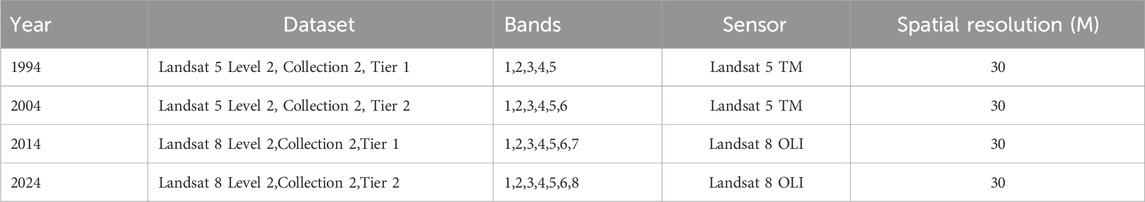
Table 1. The data set details used in the study.
Satellite image pre-processing and classification were conducted to ensure high-quality land cover images for the case studies. All datasets were projected to UTM zone 36N using the WGS84 datum. We applied both unsupervised and supervised classification methods to identify LULC. Accuracy assessment plays a crucial role in LCC as it evaluates the effectiveness of pixel grouping against geographically referenced data. We utilised statistical models, including multiple linear regression and error metrics, for this purpose (Zarei et al., 2024). The LULC classification schema (Table 2) was based on the Atlas of Malawi Classification System and the Community Knowledge (Food and Agriculture Organisation, 2020).
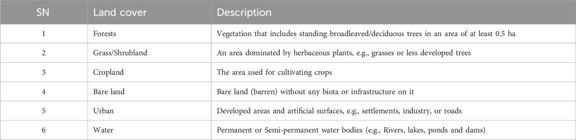
Table 2. LULC classification.
2.2.3 Accuracy assessment
Overall, the accuracy of the LCC was calculated as follows (Equation 1):
where
2.3 Survey data
2.3.1 Secondary data
The UN University’s Sustainability Analytics, Informatics and Data (Sustainability AID) Flood Module was used to access the Malawi Flood and Drought Monitor (MAL-FDM) Version 2.0 under the Africa Drought and Flood Monitor Programme (AFDM). This tool explored key climatic variables (Precipitation, Evaporation, Evapotranspiration, and temperature) for modelling the WEFC Nexus (Ramos et al., 2022). Hydro-power data came from Electricity Generation Company (EGENCO) records, while biomass energy and meal access data were sourced from the National Statistics Office (NSO) database (Table 3). These variables are vital for assessing water, energy, and food security, as well as climate resilience, for the WEFC Nexus from 1994 to 2024.
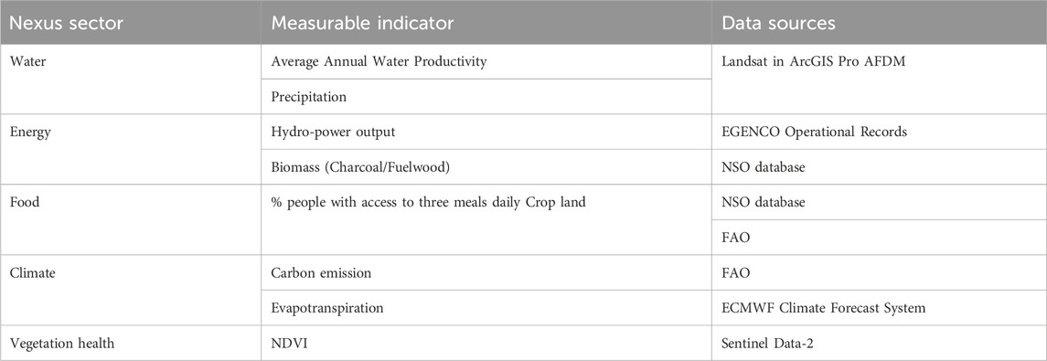
Table 3. Variables considered in modelling WEFC Nexus.
2.3.2 Primary data collection
Qualitative data were collected through a directed literature review, ethnographic techniques, Focus group discussions (FGDs), Key Informant Interviews (KIIs), and Expert interviews (EIs). These data were analysed by deductive content analysis to provide complementary evidence to findings from geospatial analysis (Figure 3).
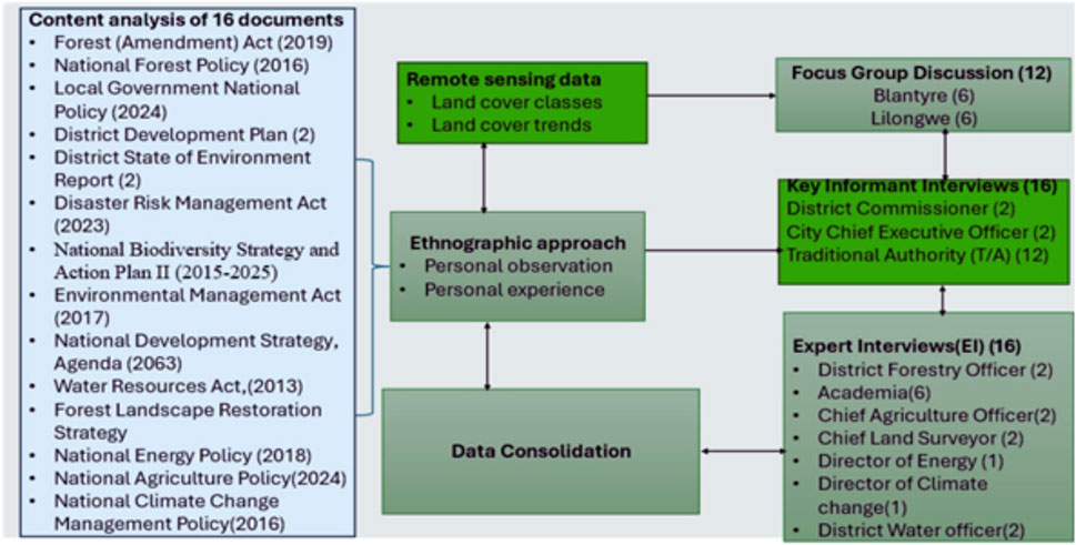
Figure 3. Data collection chart for the study.
2.4 Data analysis
2.4.1 Spatial data analysis
Using the Change Detection Wizard, we analysed land cover changes in Blantyre and Lilongwe Districts over three periods (e.g., 1994–2004, 2004–2014, and 2014–2024). Using a transition matrix, we analysed significant inter-category transitions by comparing observed and expected values, to determine if changes were random or systematic (Mawenda et al., 2020). A transition is random if there’s no difference between these values and systematic if there is a notable deviation. We calculated the expected values in terms of gain,
where (P+j-Pjj) = observed total gross gain of land cover class j,Pi+ = the size of category I in the start date (e.g., 1994), in our case, the sum of all six land cover classes of j in the start date.
where (Pi+-Pii) = observed total gross loss of a land cover class j,P+j is the size of category j on the last date of the evaluation (e.g., 2024) in the case of our study.
2.4.2 Statistical trend test analysis
To measure the nexus between water, energy, food, and climate, the initial stage involved identifying key interactions based on the LCT. For instance, in the water-energy nexus, energy-food nexus, and climate-food nexus. Spatial and temporal alignment were performed to ensure that datasets share the exact resolution and time intervals (e.g., annually).
Additionally, unit standardisation is essential for converting all measurements into compatible units, which allows for consistent comparisons. (e.g., millimetres per year for precipitation, tons per hectare for crop yield, and degrees Celsius for temperature). The analysis phase involved multiple techniques to quantify nexus relationships. Correlation analysis (using the Pearson method) in R was conducted to identify statistical dependencies, such as how NDVI (vegetation health) shaped by LCT correlates with precipitation (water) and temperature (climate). Using geospatial overlay techniques in the ArcGIS software, mapping interactions were performed. The goal was to compare key resource nexuses associated with a land cover class. For example, cropland (food) with groundwater salinity (water) or assessing the relationship between hydropower output (energy) and flood frequency (water).
Furthermore, the non-parametric Mann-Kendall trend test (Mann, 1945; Kendall, 1975) was employed to analyse time-series trends of LULC change for Blantyre and Lilongwe (1994–2024) using at least three indicators in each Nexus resource. For instance, to test whether declining soil nutrients (food) coincide with increasing biomass dependency (energy), or how carbon sequestration (climate) trends align with NDVI (vegetation health) (Stedinger et al., 1993). This method is particularly suitable for this study’s data as it: 1 does not require normally distributed data, 2 is robust against missing values and outliers, 3 can handle non-linear trends, and 4 measures the strength and direction of the LULC trends (Stedinger et al., 1993). Mann-Kendall trend test (S) is measured as follows (Equations 4, 5).
Where:
• n = number of observations,
• xi, xj = data values at times ii and jj,
• sgn () = the sign function:
Interpretation of S:
• S > 0 → Increasing trend,
• S = 0 → No trend,
• S < 0 → Decreasing trend.
To assess the significance of the trends, Standardised Test Statistics (the Z-score) for LULC changes were computed to determine the standard normal distribution (e.g., Z1−α/2 for a two-tailed test at significance level α) (Equation 6).
• Z > 0 → Upward trend,
• Z < 0 → Downward trend.
Since trends were observed, Sen’s Slope (Q) Estimator was employed to estimate the magnitude of the trends (Equation 7).
These methods collectively provide a robust basis for measuring the effects of LCT on the Water-Energy-Food-Climate Nexus.
2.4.3 Qualitative data
The qualitative dataset, comprising literature, FGDs, KIIs, EIs and ethnographic observations, was analysed using a deductive content analysis approach (Creswell and Creswell, 2018). The aim of combining these methods was to triangulate with quantitative results, thereby enhancing the study’s methodological rigour and construct validity. The qualitative component provided a nuanced interpretation of quantitative findings and further explored unexpected insights, ultimately strengthening the validity and robustness of our research conclusions (Tashakkori et al., 2021).
3 Results
3.1 Trends of LCC in southern Africa from 1994 to 2024
3.1.1 LCC trends in Blantyre (1994–2024)
The visual representation of LCC in Blantyre District from 1994 to 2024 reveals significant transformations across six broad land cover classes (Figure 4). The trends suggest a notable expansion of cropland and urban areas, at the expense of forest and grassland cover.
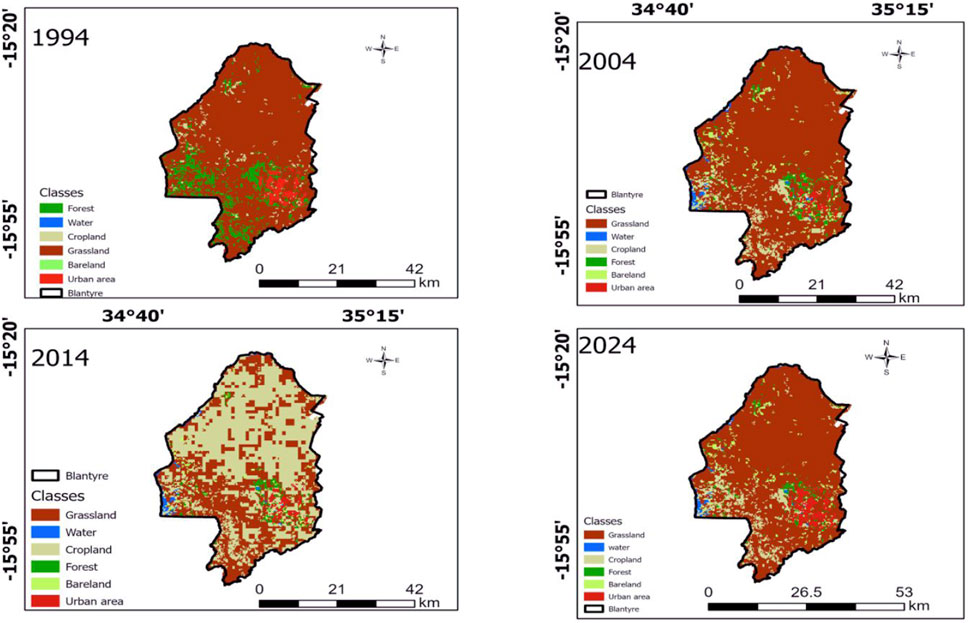
Figure 4. Land cover maps for Blantyre in 1994, 2004, 2014, and 2024.
Significant land cover changes were observed in southern Africa, particularly in cropland, urban areas, and forests. In this context, further statistical tests were conducted to examine these three key trends.
The deforestation pattern demonstrated a near-perfect negative correlation (τ = −0.93) with exceptionally high statistical confidence (Z = −6.72, p < 0.001). This significant deforestation signifies an ecological crisis, endangering biodiversity, reducing carbon sequestration capacity, and degrading vital ecosystem services. Multiple factors, including logging activities and land conversion for agricultural and urban expansion, are connected to deforestation. The contrasting trajectories of cropland expansion and forest loss suggest a direct relationship between these land cover changes, with agricultural encroachment appearing as a primary driver of deforestation in the region. These findings underscore the pressing need for balanced land management strategies that balance both food security requirements and environmental conservation priorities.
The Mann-Kendall trend analysis for Blantyre (1994–2024) revealed significant and divergent changes in the top three land cover classes (Table 4). Cropland showed a strong increasing trend, expanding at a rate of +892.14 ha/year (Sen’s slope), supported by a moderate-to-strong positive correlation (τ = 0.58) and high statistical significance (Z = 3.71, p = 0.0002). Despite minor fluctuations after 2011, the overall trend indicates rapid agricultural expansion, likely driven by land-use intensification and land conversion. Urban areas exhibited a gradual but statistically significant increase, growing at +3.21 ha/year (τ = 0.45, Z = 3.56, p = 0.0004).
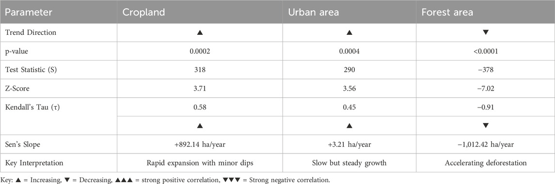
Table 4. Land cover trends for selected classes in Blantyre (1994–2024).
This aligns with the qualitative insights from qualitative approaches such as ethnography, FGD, KII and EI. For instance, Senior Chief Kunthembwe attributed these changes to population growth-driven demands for food and energy, which have resulted in deforestation and agricultural expansion.
“We allocate more land for crops because the population is growing, and we need to produce more food and energy for our immediate survival. As a result, we have no choice but to cut more trees and extend our farmlands to forest areas … ’’ Senior Chief Kunthembwe, KII. 2 in Blantyre District.
The testimony from Senior Chief Kunthembwe provides a critical socio-economic narrative that explains the quantitative LULC changes observed in this study through remote sensing. His statement encapsulates that population growth acts as the primary driver, creating immense pressure for food and energy security. This pressure manifests as the conversion of forested areas to cropland, directly related to the state of the land as identified in the LULC classification. The phrase “we have no choice but to cut more trees” is particularly significant, highlighting a lack of viable alternatives and underscoring the poverty-environment nexus. In this complex dynamic, immediate human needs for survival are prioritised over long-term environmental sustainability, leading to a potentially negative feedback loop.
The ensuing deforestation and land degradation threaten essential ecosystem services, including biodiversity, carbon sequestration, and soil fertility, which are foundational to agricultural resilience and community wellbeing. Consequently, the Chief’s account transcends mere observation; it serves as a powerful diagnostic of systemic failure. It implies that effective land management policies must extend beyond conservation mandates to address these root socio-economic drivers by providing accessible pathways for sustainable agricultural intensification, clean energy alternatives, and diversified economic opportunities, thereby creating choices where currently none are perceived to exist.
3.1.2 LCC trends in Lilongwe District (1994–2024)
The geospatial analysis of LULC change in Lilongwe District from 1994 to 2024 (Figure 5) reveals a significant transformation of the landscape, characterised by a decline in forest cover, particularly within the Dzalanyama Forest Reserve, and an expansion of agricultural land, bare land, and urban settlements.
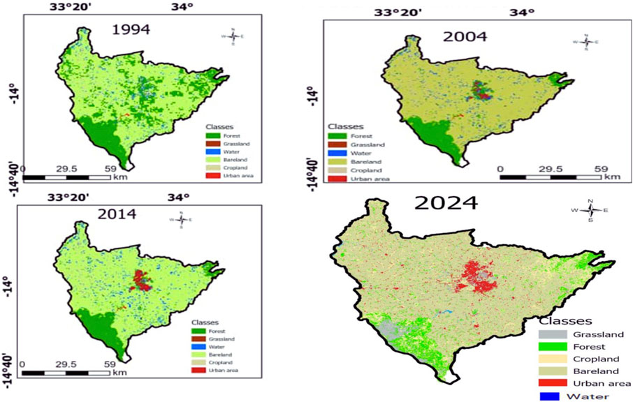
Figure 5. Land cover maps for Lilongwe in 1994, 2004, 2014, and 2024.
Forest cover exhibited the most concerning trend, with accelerated deforestation at −1,012.42 ha/year, the fastest among all land categories. The near-perfect negative correlation (τ = −0.91) and highly significant statistical results (Z = −7.02, p < 0.0001) underscore a consistent and severe decline. This loss probably stems from encroachment by cropland and urban areas, with severe implications for biodiversity and ecosystem services. The contrasting trends are cropland expansion and increasing urban areas, indicating a direct trade-off in land use. Meanwhile, urban growth, although modest, may indirectly worsen deforestation through increased resource demand. These findings highlight the urgency for policies that promote agricultural sustainability, forest conservation, and controlled urban development in Blantyre.
The Mann-Kendall trend analysis (Table 5) showed significant changes in Lilongwe’s LCC between 1994 and 2024.
Table 5. Land cover trends of selected classes in Lilongwe (1994–2024).
The cropland showed a strong increasing trend, expanding at a rate of 4,734.45 units per year, the most rapid change among all land cover classes. This dramatic expansion was supported by a near-perfect positive correlation (Kendall’s τ = 0.89) and overwhelming statistical significance (Z = 6.03, p < 0.001), indicating that systematic agricultural intensification was likely driven by population growth and increasing food demand.
The quantitative findings were confirmed by the qualitative testimony from Senior Chief Tsabango, who provided a critical socio-economic lens through which to interpret these quantitative changes.
‘Every day, a lot of people, especially men from other districts, come to ask for land from us to grow tobacco. Some just want to relocate and look for jobs in the capital city. This triggers rapid population growth, which in turn increases the demand for biomass energy. Most of them, if they cannot find a job, start a charcoal business. They produce charcoal from indigenous trees, particularly from the Dzalanyama Forest Reserve … ’ said Senior Chief Tsabango, KII.3 in Lilongwe.
He identified immigration and commercial tobacco farming as key direct drivers of deforestation. This migration fuels a feedback loop: population growth increases the demand for land and energy, which in turn leads to forest degradation for charcoal production. A common livelihood strategy when formal employment is scarce. The conversion of forest to agricultural and bare land threatens ecosystem services, including biodiversity loss, reduced carbon sequestration, and soil degradation. This analysis highlights that the observed LULC changes are not merely environmental issues, but rather symptomatic of deeper systemic drivers, including economic pressures and a lack of alternative livelihood options.
3.2 Effects of LCC on WEFC nexus
3.2.1 Effects of LCC on WEFC nexus in Blantyre District
The LCC trend analysis for Blantyre (1994–2024) (Table 6), reveals a statistically significant and environmentally critical degradation of its natural resource base, driven by LULC. A foundational trend is the significant decline in vegetation health, as indicated by a strongly negative NDVI (Z = −2.66). This degradation has a direct impact on the water sector, manifesting as a highly significant increase in evapotranspiration (Z = −4.91) and a consequent sharp decline in average water productivity (Z = 3.12). These hydrological changes have profound implications for the energy sector, correlating with a significant reduction in hydropower output and forcing a greater reliance on biomass, evidenced by a significantly increasing trend in biomass dependency (Z = 1.82).
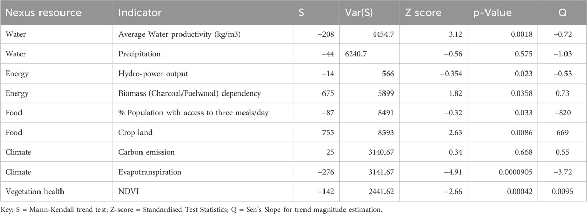
Table 6. Test statistics for nexus resources trends driven by LULC in Blantyre (1994–2024).
Despite a significant expansion of cropland (Z = 2.63), agricultural extensification has failed to improve food security, with a notable decrease in the percentage of the population having access to three meals per day. While the trend in carbon emissions remained statistically insignificant, the collective results depict a tightly coupled negative feedback loop: LULC change drives vegetation loss, which exacerbates water scarcity and energy insecurity, ultimately undermining food production systems and socio-economic wellbeing.
3.2.2 Effects of LCC on WEFC nexus in Lilongwe District
The LCC trend analysis for Lilongwe (1994–2024) (Table 7), reveals significant and statistically profound alterations in its resource nexus, driven by changes in LULC.
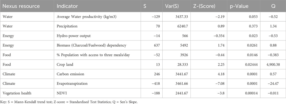
Table 7. Test statistics for nexus resources trends driven by LULC in Lilongwe (1994–2024).
A severe decline in vegetation health is indicated by a highly significant negative trend in NDVI (Z = −3.8), which forms a critical baseline. This degradation has catalysed a cascade of effects across interconnected sectors. The water sector is under considerable strain, with a highly significant increase in evapotranspiration (Z = −7.08) contributing to a notable, albeit marginally significant, decline in water productivity (Z = −2.19). Energy security is increasingly compromised, marked by a significant decrease in hydropower output and a corresponding significant rise in dependency on biomass fuels (Z = 1.74). Despite a significant expansion of cropland (Z = 2.25), food security has deteriorated, as indicated by a significant reduction in the population with access to three meals per day. Furthermore, these LULC changes have triggered a major climatic feedback, with a highly significant increase in carbon emissions (Z = 4.18). Collectively, these results illustrate a vicious cycle wherein LULC change drives vegetation loss, which intensifies water and energy scarcity, undermines agricultural gains, and exacerbates climate change, thereby locking the city into a trajectory of deepening resource insecurity and socio-ecological vulnerability.
4 Discussion
4.1 Trends of LCC in southern Africa from 1994 to 2024
The study reveals significant transformations that reflect broader socio-economic and environmental dynamics driven by LCC in southern Africa from 1994 to 2024. Both case studies exhibit dynamic LCC characteristics, particularly in cropland, urban areas, and forest cover.
The application of the non-parametric Mann-Kendall trend test and Sen’s slope estimator is methodologically sound for analysing such temporal remote sensing data, as they are resistant to outliers and non-normal data distributions, common in environmental time series (Hussain and Mahmud, 2019). The results unequivocally demonstrate a dominant land cover transition pathway: the systematic and significant conversion of forested areas to cropland and urban surfaces, a trend consistently observed across Southern Africa but with distinct local dynamics (Xie et al., 2022).
In Blantyre, the deforestation rate, characterised by a near-perfect negative correlation, signifies an ecological crisis. This loss directly undermines Malawi’s carbon sequestration capacity, a critical concern given its vulnerability to climate change, and degrades essential ecosystem services, including water regulation and soil conservation (Martin et al., 2022). The concurrent, rapid expansion of cropland, with a strong positive trend, strongly suggests that agricultural encroachment is the primary direct driver. This aligns with the global discourse on the “forest-agriculture nexus,” where food security needs are often pitted against conservation goals (Phiri et al., 2021). While Blantyre’s urban growth is modest, its statistical significance indicates persistent pressure. Lilongwe, as the national capital city, presents an even starker contrast: its urban growth is the most rapid among the reported changes, while also experiencing the fastest expansion of cropland and significant deforestation. This indicates that Lilongwe is facing a dual pressure of extensive agricultural frontier expansion and capital-city-driven urbanisation, a combination that places immense strain on remaining natural ecosystems.
While the statistical analysis is rigorous, a key limitation inherent in such trend studies is the attribution of causality. The Mann-Kendall test confirms the existence and magnitude of trends and correlations, but does not prove that cropland expansion directly causes forest loss, though the spatial and temporal correlation is highly suggestive. Future research integrating spatial regression models or agent-based modelling could more explicitly test these causal pathways.
In Lilongwe, the significant expansion of cropland is primarily driven by a growing demand for food resulting from the region’s expanding population (Nhamo et al., 2016). However, this expansion comes at a steep ecological cost, as forest cover experiences alarming rates of decline due to deforestation for agricultural land and logging activities, which ultimately threaten biodiversity and essential ecosystem services. Similar patterns are evident in Blantyre, where urban development further complicates land-use dynamics by adding additional pressures to existing forest reserves (Phiri and Nyirenda, 2022).
The disintegration of forest cover is fundamentally intertwined with the expansion of cropland and urban areas, wherein each expansion amplifies the impacts on the other, creating a cyclical dilemma in land management (Skole et al., 2021). Indeed, the interplay between agricultural growth and urbanisation manifests in negative environmental ramifications, with urban growth exerting pressure on municipal infrastructure and exacerbating resource depletion, thereby indirectly fostering deforestation through increased demand for natural resources (Kpienbaareh et al., 2022).
Community testimonies, such as that from Senior Chief Kunthembwe, provide critical empirical insight into the socio-economic drivers of land cover change, moving beyond quantitative data to explain the underlying causality (Siampale et al., 2023). These accounts reveal that population growth exerts direct pressure on land resources, compelling communities to convert forests into cropland for food and energy production—a rational yet unsustainable livelihood strategy that reflects the classic poverty-environment nexus (Nelson et al., 2021). This highlights that deforestation is not merely an environmental issue, but a symptom of deeper socio-economic constraints, where immediate human needs are prioritised over long-term ecological sustainability, a concept increasingly framed as “environmental livelihood trade-offs” (Ryan et al., 2022).
Consequently, effective environmental governance must address these root causes by promoting context-specific sustainable agricultural intensification (De Bonvoisin et al., 2024) and providing affordable, clean energy alternatives, such as advanced biomass cookstoves and targeted solar interventions, to break the cycle of degradation and preserve vital ecosystem services (McCauley et al., 2022; IEA, 2023). Evidence suggests that while such agricultural expansion can enhance livelihoods, its implementation must be accompanied by robust environmental stewardship to avoid exacerbating deforestation rates (Kpienbaareh et al., 2022). According to Ngwira and Watanabe (2019), integrating local perceptions of land use and agricultural practices into intervention design respects local cultural contexts and harnesses traditional knowledge for sustainable land management solutions.
The situation surrounding land use dynamics in this study offers a contemporary example of the trade-offs and complex interactions inherent in agricultural expansion, urban growth, and environmental conservation. Policymakers must navigate the competing demands of agricultural productivity and urban development while striving to conserve critical ecosystems. Building effective monitoring systems to track land use changes will be vital, as will fostering community engagement to empower local stewardship of natural resources. This multi-faceted approach is essential for ensuring the sustainable use of land while meeting the pressing food and energy needs of a growing population (Skole et al., 2021; Li et al., 2024).
The results present strong scientific evidence of a significant and ongoing transformation of land systems in southern Africa. These trends are not random; they are systematic, significant, and influenced by deep-seated socio-economic pressures. The findings underscore the pressing need for integrated land-use planning that transcends isolated approaches. Effective policies must address the pressing need for food and energy security through sustainable intensification and alternative livelihoods, while also rigorously protecting the remaining forest ecosystems. Community-based conservation models that provide tangible benefits to local populations can help create choices where none previously existed.
Thus, the findings emphasise the dual challenge of ensuring food security while also conserving and enhancing water security, biodiversity, ecosystem services, and resilience to climate change. Effective land management strategies should focus on conservation efforts and address the underlying socio-economic drivers that contribute to significant changes in land cover. Policymakers need to consider pathways for sustainable agricultural practices and alternative energy solutions that reconcile immediate needs with long-term ecological health.
4.2 Effects of LCC on WEFC nexus in southern Africa
The effects of LCC on the WEFC nexus in Southern Africa underscore a concerning trajectory. The Mann-Kendall trend analysis in Blantyre and Lilongwe districts reveals a consistent degradation of natural resources from 1994 to 2024. There is a notable decline in vegetation health, as evidenced by a strongly negative trend in the NDVI. The loss of vegetation reflects larger ecological disruptions and is consistent with findings from various geographical contexts (Afionis et al., 2020). Research indicates that changes in LULC significantly impact local climatic conditions, including evapotranspiration rates, which are crucial for sustaining water balance and ecosystem health (Li et al., 2018; Ramos et al., 2022; Islam and Shahriar, 2023; Kalyan and Pathak, 2024; Yang et al., 2024). As vegetation cover diminishes due to agricultural expansion and urbanisation, evapotranspiration loss exacerbates hydrological stress, thereby affecting agricultural outputs and energy production (Mondal and Zhang, 2018; Okoduwa and Amaechi, 2024).
The results also highlight that LULC have a negative impact on the energy sector, reducing hydropower generation and increasing reliance on biomass fuels for heating and lighting. While Blantyre shows no significant effects, Lilongwe faces notable sustainability issues related to deforestation and carbon emissions (Okoduwa and Amaechi, 2024; Damaneh et al., 2021). Such findings reflect a maladaptive coping strategy typical of most southern African countries during energy crises (van der Zwaan et al., 2018). The excessive extraction of biomass, further exacerbated by extensive logging, mostly in protected areas (Makwinja and Mkhwimba, 2025), destabilises hydropower production (Mukoro et al., 2023). This situation suggests the need for targeted policy interventions (Gwenzi, 2022; IPCC, 2022).
The food security paradox reported in this study also highlights that increased cropland does not always ensure food security. In Blantyre and Lilongwe, many people struggle to secure three meals a day, showing that merely expanding agricultural land is insufficient without effective resource management and socio-economic support (Nguyen et al., 2021). The decline in food security, despite a significant increase in cropland growth, is linked to systemic issues such as resource mismanagement and climate change (Simpson and Jewitt, 2019). LCC negatively impact agricultural productivity and increases food insecurity in the region (Mutale and Fan, 2024; Akodéwou et al., 2020). Climate change worsens these challenges by impacting crop resilience (Kansman et al., 2020). A comprehensive approach focusing on governance, community engagement, and sustainable practices is essential for enhancing food security and protecting vulnerable populations (Yen et al., 2021).
The rising carbon emissions in Lilongwe, driven by urbanisation and deforestation, contrast with Blantyre’s stable emissions, highlighting the complexities of urban transformation and its environmental impacts in Southern Africa. A significant reduction in evapotranspiration and a decline in NDVI in both case studies indicate ecosystem stress and loss of vegetation. Both case studies show a positive correlation between NDVI and precipitation, underscoring the interactions within the WEFC Nexus.
The Mann-Kendall test reveals a significant downward trend in NDVI for Lilongwe from 1994 to 2024, which is linked to deforestation, climate variability, and land-use changes. A similar decline in Blantyre indicates worsening vegetation health. These trends highlight the negative impacts of deforestation on rainfall and agricultural productivity, disrupting co-benefits among environmental resources. Urban expansion exacerbates challenges for vegetation, increases land temperatures, threatens biodiversity, and complicates the analysis of environmental change (Zhao et al., 2023). Climate change further undermines food security by altering precipitation and increasing droughts, heightening community vulnerabilities. Adopting nature-positive strategies is essential for enhancing resilience. This study suggests that the WEFC Nexus approach is effective for addressing the co-benefits and trade-offs among environmental resources in Southern Africa’s ecological crises.
5 Conclusion
The land cover trends for Malawi identify a highly unsustainable trajectory characterised by strong inter-sectoral competition, which places severe strain on the WEFC Nexus. The most significant transition is the conversion of forested land to agricultural use, driven by both subsistence and cash crop farming. The shift has a negative impact on watershed functions, leading to increased runoff, soil erosion, and reservoir siltation, which compromise water quality and raise treatment costs. While agricultural land may temporarily expand, long-term food security is threatened by soil degradation. This cycle contributes to climate change as the loss of carbon sinks exacerbates global warming, leading to more frequent droughts and floods. The conversion of forests to cropland degrades water and energy resources, driving migration to cities and contributing to further urban expansion. Increased urban demands for resources may lead to proposals for new dams, which could result in more deforestation and ecosystem degradation, thereby deepening resource insecurity and complicating crisis management.
This study’s methodological framework and findings, while focused on Malawi, provide a model for analysing the WEFC Nexus in similar socio-ecological contexts in Southern Africa. It highlights that sustainable land management is linked to effective governance. However, since the research concentrated on two case studies in Malawi’s central and southern regions, results may differ in the eastern and northern areas due to varying socio-economic and ecological profiles. The integration of remote sensing data with local input highlights a socio-environmental feedback loop in which immediate subsistence needs often overshadow long-term sustainability, leading to land degradation and the loss of ecosystem services. The two cases mirror the realities and highlight limitations, such as regions that were not taken into consideration. If they were considered, they could provide new insights.
The study limitations necessitate a fundamental shift in policy and research. Future studies should therefore focus on exploring 1 Resource Nexus and Transformative governance of environmental resources at different scales. 2 Participatory spatial-temporal planning for effective land use decisions and nature-positive sustainable development practices. 3 Diversification and Transformation of the energy technologies to reduce pressure from the forest 4 Adoption of nature-positive sustainable development practices to build systemic resilience among local communities.
Data availability statement
The raw data supporting the conclusions of this article will be made available by the authors, without undue reservation.
Author contributions
YM: Conceptualization, Formal Analysis, Investigation, Methodology, Validation, Visualization, Writing – original draft, Writing – review and editing. PO’F: Conceptualization, Investigation, Methodology, Project administration, Resources, Supervision, Validation, Writing – original draft, Writing – review and editing. JK: Conceptualization, Methodology, Supervision, Validation, Writing – review and editing, Writing – original draft. EG: Funding acquisition, Project administration, Resources, Software, Supervision, Writing – review and editing, Writing – original draft.
Funding
The author(s) declare that financial support was received for the research and/or publication of this article. This research was funded by DAAD-EPOS through the Resource Nexus for Sustainability Transformation Programme (NEXtra) Programme.
Acknowledgments
We further thank Technische Universität Dresden through the Faculty of Environmental Science for covering open access publication costs.
Conflict of interest
The authors declare that the research was conducted in the absence of any commercial or financial relationships that could be construed as a potential conflict of interest.
Generative AI statement
The author(s) declare that no Generative AI was used in the creation of this manuscript.
Any alternative text (alt text) provided alongside figures in this article has been generated by Frontiers with the support of artificial intelligence and reasonable efforts have been made to ensure accuracy, including review by the authors wherever possible. If you identify any issues, please contact us.
Publisher’s note
All claims expressed in this article are solely those of the authors and do not necessarily represent those of their affiliated organizations, or those of the publisher, the editors and the reviewers. Any product that may be evaluated in this article, or claim that may be made by its manufacturer, is not guaranteed or endorsed by the publisher.
References
Afionis, S., Mkwambisi, D., and Dallimer, M. (2020). Lack of cross-sector and cross-level policy coherence and consistency limits urban green infrastructure implementation in Malawi. Front. Environ. Sci. 8, 558619. doi:10.3389/fenvs.2020.558619
Akodéwou, A., Oszwald, J., Gazull, L., and Akpavi, S. (2020). Land use and land cover change in the landscape of burkina Faso’s classified forest: the case of the deux balé classified forest. Bois Forêts des Tropiques 345, 15–30. doi:10.19182/bft2020.345.a31817
Austin, K. G., Schwantes, A., Gu, Y., and Kasibhatla, P. S. (2019). What causes deforestation in Indonesia? Environ. Res. Lett. 14, 024007. doi:10.1088/1748-9326/aaf6db
Bhave, A. G., Bulcock, L., Dessai, S., Conway, D., Jewitt, G., and Dougill, A. J. (2022). Lake Malawi’s threshold behaviour: a stakeholder-informed model to simulate sensitivity to climate change. J. Hydrology 605, 127375. doi:10.1016/j.jhydrol.2021.127375
Bone, R. A., Parks, K. E., Hudson, M., Tsirizeni, M., and Willcock, S. (2016). Deforestation since Independence: a quantitative assessment of four decades of land-cover change in Malawi. South. For. A J. For. Sci. 79, 269–275. doi:10.2989/20702620.2016.1233777
Braimoh, A. K. (2006). Random and systematic land-cover transitions in northern Ghana. Agric. Ecosyst. Environ. 113 (1-4), 254–263. doi:10.1016/j.agee.2005.10.019
Brouwer, F., Caucci, S., Karthe, D., Kirschke, S., Madani, K., Mueller, A., et al. (2023). Advancing the resource nexus concept for research and practice. Sustain. Nexus Forum 31 (1), 41–65. doi:10.1007/s00550-023-00599-1
Bryan, B. A., Nolan, M., McKellar, L., Connor, J. D., Newth, D., Harwood, T., et al. (2018). Land-use and sustainability under intersecting global change and domestic policy scenarios: trajectories for Australia to 2050. Glob. Environ. Change 48, 130–152. doi:10.1016/j.gloenvcha.2017.11.003
Callahan, C. W. (2025). Present and future limits to climate change adaptation. Nat. Sustain. 8 (4), 336–342. doi:10.1038/s41893-025-01519-7
Creswell, J. W., and Creswell, J. D. (2018). Research design: qualitative, quantitative, and mixed methods approaches. 5th ed. Sage Publications.
Damaneh, H. E., Barzehkar, M., and Salajegheh, A. (2021). The impact of land use and land cover changes on soil erosion in the tajan watershed. Environ. Earth Sci. 80, 1–15. doi:10.1007/s12665-021-09992-x
De Bonvoisin, I., Chomba, S., and Kusters, K. (2024). Context-specific pathways for sustainable agricultural intensification in Sub-Saharan Africa. International Institute for Environment and Development. Available online at: https://www.iied.org/22314iied
Fischer, J., Abson, D. J., Bergsten, A., French Collier, N., Dorresteijn, I., Hanspach, J., et al. (2023). Reframing the food-biodiversity challenge. Trends Ecol. and Evol. 38 (5), 404–408. doi:10.1016/j.tree.2023.02.007
Food and Agriculture Organisation (FAO) (2020). Atlas of Malawi land use and land cover changes. Rome: FAO.
Gambe, T. R., Turok, I., and Visagie, J. (2023). The trajectories of urbanisation in Southern Africa: a comparative analysis. Habitat Int. 132, 102747. doi:10.1016/j.habitatint.2023.102747
Gondwe, M. F., Cho, M. A., Chirwa, P. W., and Geldenhuys, C. J. (2019). Land use, land cover change, and the comparative impact of co-management and government management on the forest cover in Malawi (1999–2018). J. Land Use Sci. 14 (4–6), 281–305. doi:10.1080/1747423X.2019.1706654
Government of Malawi (2023). The digest of Malawi energy statistics. Lilongwe, Malawi: Ministry of Energy. Available online at: http://www.energy.gov.mw/download/30/miscellaneous-documents/2461/.
Gwenzi, W., and Tiwari, V. (2022). Rapid 3D geophysical imaging of aquifers in diverse hydrogeological settings. Water Secur. 15, 100111. doi:10.1016/j.wasec.2022.100111
Herrera-Franco, G., Bollmann, H. A., Pasqual Lofhagen, J. C., Bravo-Montero, L., and Carrión-Mero, P. (2023). Approach on water-energy-food (WEF) nexus and climate change: a tool in decision-making processes. Environ. Dev. 46, 100858. doi:10.1016/j.envdev.2023.100858
Hussain, M., and Mahmud, I. (2019). pyMannKendall: a python package for non parametric mann kendall family of trend tests. J. Open Source Softw. 4 (39), 1556. doi:10.21105/joss.01556
Hutchings, P., Willcock, S., Lynch, K., Bundhoo, D., Brewer, T., Cooper, S., et al. (2022). Understanding rural-urban transitions in the global South through peri-urban turbulence. Nat. Sustain. 5 (11), 924–930. doi:10.1038/s41893-022-00920-w
Intergovernmental Panel on Biodiversity and Ecosystem Services (IPBES) (2018). in The IPBES assessment report on land degradation and restoration. Editors L. Montanarella, R. Scholes, and A. Brainich (Secretariat of the Intergovernmental Science-Policy Platform on Biodiversity and Ecosystem Services). Cambridge University Press.
Intergovernmental Panel on Climate Change (IPCC) (2022). Climate change 2022: impacts, adaptation and vulnerability. Contribution of working group II to the sixth assessment report of the intergovernmental panel on climate change. Cambridge University Press.
Islam, M. S., Shahriar, S. A., Kim, J., Spies, N. P., and Nadig, A. (2023). A simple but novel approach to calculate seabird light fallout: a case study from Kauaʻi. Environ. Challenges 11, 100689. doi:10.1016/j.envc.2023.100689
Jørstad, H., and Webersik, C. (2016). Vulnerability to climate change and adaptation strategies of local communities in Malawi: experiences of women fish-processing groups in the Lake Chilwa basin. Earth Syst. Dyn. Discuss. 7, 977–989. doi:10.5194/esd-7-977-2016
Kalyan, R., Pathak, N., Ma, Y., Zhang, C., Zhang, D., and Wang, X. (2024). Assessing the impact of land use land cover change on regional climate and hydrology: a systematic review. Sci. Total Environ. 907, 167923. doi:10.1016/j.scitotenv.2023.167923
Kansman, J. T., Cissé, G., Kinney, P. L., Schrijver, A. P., and van Zanten, H. (2020). Climate change and crop resilience in sub-Saharan Africa: a review of impacts and adaptations. Glob. Food Secur. 26, 100404. doi:10.1016/j.gfs.2020.100404
Kapute Mzuza, M., Zhang, W., Kapute, F., and Wei, X. (2019). The impact of land use and land cover changes on the nkula dam in the middle shire River Catchment, Malawi. IntechOpen. doi:10.5772/intechopen.86452
Kimengsi, J. N., Mukong, A. K., Giessen, L., and Pretzsch, J. (2022). Institutional dynamics and forest use practices in the santchou landscape of Cameroon. Environ. Sci. and Policy 128, 68–80. doi:10.1016/j.envsci.2021.11.010
Kpienbaareh, D., Luginaah, I., and Bezner Kerr, R. (2022). Urban expansion and its impact on forest resources and ecosystem services in peri-urban areas of Malawi land use policy. arXiv 120, 106267. doi:10.1016/j.landusepol.2022.106267
LeBrasseur, R. (2022). Linking human wellbeing and urban greenspaces: applying the SoftGIS tool for analyzing human wellbeing interaction in helsinki, Finland. Front. Environ. Sci. 10, 950894. doi:10.3389/fenvs.2022.950894
Li, Q., Shi, X., Zhao, Z., and Wu, Q. (2024). Reference ecosystem construction and adaptive restoration effect evaluation: A case study of a small watershed in the loess hilly region. Land Degrad. Dev. 35 (12), 3802–3816. doi:10.1002/ldr.5169
Li, Y., Zhao, M., Motesharrei, S., Mu, Q., Kalnay, E., and Li, S. (2018). Local cooling and warming effects of forests based on satellite observations. Nat. Commun. 9 (1), 1–8. doi:10.1038/s41467-018-07728-3
Mabhaudhi, T., Mpandeli, S., Nhamo, L., Chimonyo, V. G. P., Nhemachena, C., Senzanje, A., et al. (2018). Prospects for improving irrigated agriculture in Southern Africa: linking water, energy and food. Water 10, Article No. 1881. doi:10.3390/w10121881
Makwinja, Y. H., and Mkhwimba, D. (2025). Extensive logging in miombo woodlands threatens resource nexus potential for diverse values of nature: lessons from dzalanyama forest reserve in Malawi. Front. For. Glob. Change 8, 1610680. doi:10.3389/ffgc.2025.1610680
Mann, H. B. (1945). Nonparametric tests against trend. Econ. J. Econ. Soc. 13 (3), 245–259. doi:10.2307/1907187
Martin, A., O'Farrell, P., Kumar, R., Eser, U., Faith, D. P., Gomez-Baggethun, E., et al. (2022). “Chapter 5: the role of diverse values of nature in visioning and transforming towards just and sustainable futures,” in Methodological assessment report on the diverse values and valuation of nature of the intergovernmental science-policy platform on biodiversity and ecosystem services. Editors M. Christie, P. Balvanera, U. Pascual, B. Baptiste, and D. González-Jiménez (Bonn, Germany: IPBES Secretariat). doi:10.5281/zenodo.6522326
Masolele, R. N., Marcos, D., De Sy, V., Abu, I., Verbesselt, J., Reiche, J., et al. (2024). Mapping the diversity of land uses following deforestation across Africa. Sci. Rep. 14 (1), 1681–16. doi:10.1038/s41598-024-52138-9
Mawenda, J., Watanabe, T., and Avtar, R. (2020). An analysis of urban land use/land cover changes in Blantyre city, southern Malawi (1994–2018). Sustainability 12 (6), 2377. doi:10.3390/su12062377
McCauley, D., Grant, R., and Mwathunga, E. (2022). Achieving energy justice in Malawi: from key challenges to policy recommendations. Clim. Change 170 (3), 28. doi:10.1007/s10584-022-03314-1
Mondal, M. S., and Zhang, Y. (2018). Exploring the dynamics of urban sprawl using remote sensing and GIS: a case study of the kolkata urban agglomeration, India. Geocarto Int. 33 (12), 1317–1336. doi:10.1080/10106049.2017.1343393
Mukoro, V., Gallego-Sala, A. V., and Shankar, V. (2023). The impact of land-use change on hydropower potential: a global meta-analysis. Renew. Sustain. Energy Rev. 184, 113553. doi:10.1016/j.rser.2023.113553
Mutale, S. B., and Fan, S. (2024). The paradox of agricultural expansion and food insecurity in Sub-Saharan Africa: the role of land degradation and climate variability. Food Policy 123, 102585. doi:10.1016/j.foodpol.2024.102585
National Planning Commission (2020). Malawi 2063: an inclusive, wealthy, self-reliant nation. Malawi's long-term development vision. Available online at: https://www.npc.mw/wp-content/uploads/2021/04/MALAWI-2063-FINAL-for-PrintING.pdf.
National Statistical Office (NSO) (2018). Population and housing census. Be counted, leave no one behind; preliminary report. National Statistics Office: Zomba, Malawi. Available online at: http://www.nsomalawi.mw/index.php?option=com_content&view=article&id=226&Itemid=6.
Nelson, F., Nkhata, B., and Nkhoma, C. (2021). The poverty-environment nexus in Malawi: pathways and policy implications. World Dev. Perspect. 22, 100305. doi:10.1016/j.wdp.2021.100305
Nguyen, T. T., Grote, U., Neubacher, F., Do, M. H., and Paudel, G. P. (2021). Security risks from climate change and environmental degradation: implications for sustainable land use transformation in the global south. Curr. Opin. Environ. Sustain. 49, 27–34. doi:10.1016/j.cosust.2020.12.007
Ngwira, S., and Watanabe, T. (2019). An analysis of the causes of deforestation in Malawi: a case of mwazisi. Land 8 (3), 48. doi:10.3390/land8030048
Nhamo, L., Mabhaudhi, T., Modi, A. T., Tredoux, G., Genthe, B., Steyn, M., et al. (2016). Four decades of water recycling in atlantis (western cape, South Africa): past, present and future. Water sa. 42 (4), 577–591. doi:10.4314/wsa.v42i4.08
O'Farrell, P., Donaldson, J., and Hoffman, M. (2009). Local benefits of retaining natural vegetation for soil retention and hydrological services. S. Afr. J. Bot. 75 (3). 573–583. doi:10.1016/j.sajb.2009.06.008
Okoduwa, C. I., and Amaechi, E. C. (2024). Land use, land cover change, and its implications on evapotranspiration and water-energy balance in West Africa. J. Hydrology Regional Stud. 51, 101630. doi:10.1016/j.ejrh.2024.101630
Pascual, U., Balvanera, P., Anderson, C. B., Chaplin-Kramer, R., Christie, M., González-Jiménez, D., et al. (2023). Diverse values of nature for sustainability. Nature 620 (7975), 813–823. doi:10.1038/s41586-023-06406-9
Phiri, D., and Nyirenda, E. (2022). Urban development pressure on forest reserves in Malawi: a case study of Blantyre. Trees, For. People 8, 100226. doi:10.1016/j.tfp.2022.100226
Phiri, D., Morgenroth, J., and Xu, C. (2019). Long-term land cover change in Zambia: an assessment of driving factors. Sci. Total Environ. 697, 134206. doi:10.1016/j.scitotenv.2019.134206
Phiri, D., Simwanda, M., Nyirenda, V. R., Radulović, A., and Govedarica, M. (2021). The forest-agriculture nexus in Zambia: trends, drivers, and impacts on ecosystem services. Remote Sens. 13 (16), 3150. doi:10.3390/rs13163150
Ramos, J. E., Tam, J., Aramayo, V., Briceño, F. A., Bandin, R., Buitron, B., et al. (2022). Climate vulnerability assessment of key fishery resources in the northern humboldt current system. Sci. Rep. 12 (1), 4800–4816. doi:10.1038/s41598-022-08818-5
Ryan, C. M., Pritchard, R., and Grundy, I. (2022). Environmental livelihood trade-offs in africa's dryland forests. Annu. Rev. Environ. Resour. 47, 355–379. doi:10.1146/annurev-environ-112420-020323
Sannou, R. O., and Guenther, E. (2025). Exploring the resource nexus between forest-based land restoration and food security: the case of African countries participating in the great green wall initiative. Land Use Policy 151, 107499. doi:10.1016/j.landusepol.2024.107499
Seddon, N., Chausson, A., Berry, P., Girardin, C. A., Smith, A., and Turner, B. (2021). Understanding the value and limits of nature-based solutions to climate change and other global challenges. Philosophical Trans. R. Soc. B 375 (1794), 20190120. doi:10.1098/rstb.2019.0120
Siampale, A., Syampungani, S., and Mwitwa, J. (2023). Beyond the pixels: using community testimonies to understand the socioeconomic drivers of land cover change in the miombo woodlands. Soc. and Nat. Resour. 36 (5), 543–562. doi:10.1080/08941920.2023.2172475
Simpson, G. B., and Jewitt, G. P. (2019). The development of the water-energy-food nexus as a framework for achieving resource security: a review. Front. Environ. Sci. 7, 8. doi:10.3389/fenvs.2019.00008
Skole, D. L., Masek, J. G., and Townshend, J. R. G. (2021). The cyclical dilemma of land management: feedbacks between forest loss and agricultural expansion. Glob. Change Biol. 27 (11), 2317–2329. doi:10.1111/gcb.15572
Stedinger, J. R., Vogel, R. M., and Foufoula-Georgia, E. (1993). “Frequency analysis of extreme events. Chapter 18,” in Handbook of hydrology. Editor D. R. Maidment (New York: McGraw Hill), 18.1–18.66.
Strassburg, B. B., Iribarrem, A., Beyer, H. L., Cordeiro, C. L., Crouzeilles, R., Jakovac, C. C., et al. (2020). Global priority areas for ecosystem restoration. Nature 586 (7831), 724–729. doi:10.1038/s41586-020-2784-9
Tashakkori, A., Johnson, R. B., and Teddlie, C. (2021). Foundations of mixed methods research: integrating quantitative and qualitative approaches in the social and behavioural sciences. 2nd ed. Sage Publications.
Teixeira, Z., Teixeira, H., and Marques, J. C. (2014). Systematic processes of land use/land cover change to identify relevant driving forces: implications on water quality. Sci. Total Environ. 470, 1320–1335. doi:10.1016/j.scitotenv.2013.10.098
van der Zwaan, B., Kober, T., and Dalla Longa, F. (2018). The role of biomass in sub-Saharan Africa’s energy sector: a review of potential and challenges. Renew. Sustain. Energy Rev. 82, 2470–2486. doi:10.1016/j.rser.2017.09.005
Winkler, K., Fuchs, R., Rounsevell, M., and Herold, M. (2021). Global land use changes are four times greater than previously estimated. Nat. Commun. 12 (1), 2501. doi:10.1038/s41467-021-22702-2
Xiao, H., Liu, J., He, G., Zhang, X., Wang, H., Long, T., et al. (2022). Data-driven forest cover change and its driving factors analysis in Africa. Front. Environ. Sci. 9, 780069. doi:10.3389/fenvs.2021.780069
Xie, H., Zhang, Y., and Wu, Z. (2022). Spatial-temporal patterns and drivers of land use/cover change in Southern Africa from 1990 to 2020. J. Geogr. Sci. 32 (6), 1121–1142. doi:10.1007/s11442-022-1988-3
Yang, J., Huang, X., Liu, X., Liu, C. H., Chu, M., Chen, Z., et al. (2024). Revisiting the cooling effects of urban vegetation: a global meta-analysis of land surface temperature responses. Sustain. Cities Soc. 100, 105029. doi:10.1016/j.scs.2023.105029
Yen, B. T., Visser, S. M., and Keesstra, S. D. (2021). Governance and community engagement for sustainable land management: a framework for action. Land Degrad. and Dev. 32 (14), 3867–3882. doi:10.1002/ldr.4002
Zarei, A., Madani, K., Guenther, E., Nasrabadi, H. M., and Hoff, H. (2024). Integrated nexus approach to assessing climate change impacts on grassland ecosystem dynamics: a case study of the grasslands in Tanzania. Sci. Total Environ. 952, 175691. doi:10.1016/j.scitotenv.2024.175691
Keywords: land use, water, energy, food, climate, southern Africa
Citation: Makwinja YH, O’Farrell PJ, Kimengsi JN and Guenther E (2025) Land cover shifts strain resource nexus in southern Africa: evidence from Malawi. Front. Environ. Sci. 13:1665279. doi: 10.3389/fenvs.2025.1665279
Received: 13 July 2025; Accepted: 08 September 2025;
Published: 30 September 2025.
Edited by:
Muthukrishna Vellaisamy Kumarasamy, University of KwaZulu-Natal, South AfricaReviewed by:
Dinagarapandi Pandi, Vaigai College of Engineering, IndiaSaravanan Kothandaraman, VIT University Chennai, India
Copyright © 2025 Makwinja, O’Farrell, Kimengsi and Guenther. This is an open-access article distributed under the terms of the Creative Commons Attribution License (CC BY). The use, distribution or reproduction in other forums is permitted, provided the original author(s) and the copyright owner(s) are credited and that the original publication in this journal is cited, in accordance with accepted academic practice. No use, distribution or reproduction is permitted which does not comply with these terms.
*Correspondence: Yamikani Harry Makwinja, eWFtaWthbmkubWFrd2luamExQG1haWxib3gudHVkcmVzZGVuLmRl