 Wenxiang Wang1,2,3,4*
 Shengbo Yu1,2Yonghui An4Wenpeng Li5
 Yuemei Cai3Xinmin Shao4Xi Wu4Huqun Cui4Dechao Yin4Xiaoyan Wang4
- 1Key Laboratory of Groundwater Engineering and Geothermal Resources in Gansu Province, Lanzhou, China
- 2Gansu Institute of Geo-Environmental Monitoring, Lanzhou, China
- 3Weifang University, Weifang, China
- 4Center for Hydrogeology, Environment Geology Survey, China Geological Survey, Baoding, China
- 5China Institute for Geo-Environmental Monitoring, Beijing, China
The Jiuquan Basin, with area of 6,800 square kilometers, located in the arid northwest of China, is a vital part of the Hexi Corridor. Investigating its groundwater circulation model is essential for understanding regional hydrogeological processes, sustainable water resource management, and ecological protection. This study, building upon previous research, utilizes hydrogeological surveys, hydrogeochemical analysis, isotope tracing (δD and δ18O) with sample size of 439, and radiocarbon dating (14C) with sample size of 45 to evaluate the groundwater flow systems and groundwater age distribution. Results reveal that groundwater primarily originates from meltwater from the Qilian Mountains and atmospheric precipitation, flowing from south to north. The central basin exhibits slower circulation and older groundwater, while the groundwater in the Heihe River mainstream and the Beida River Basin was relatively young due to the favorable conditions for recharge and discharge. The local meteoric water line (LMWL) is defined as δD = 6.02 × δ18O- 2.5. Based on isotopic and age data, the basin is divided into several secondary groundwater flow systems (SGFS). This work contributes valuable insight into arid-zone hydrodynamics and supports ecological and water management strategies in the Jiuquan Basin.
1 Introduction
The Jiuquan Basin, situated in the arid region of northwestern China, represents a key segment of the Hexi Corridor and plays an irreplaceable role in regional socio-economic development and ecological sustainability (Wu et al., 2015). Due to its inland location, limited precipitation, and intense evaporation, groundwater has become the primary water source in the basin (Figure 1). Understanding the groundwater circulation patterns is of great significance for water resource management, ecological protection, and sustainable development in this ecologically fragile zone. As a critical buffer zone between human activities and the natural environment, the Jiuquan Basin’s hydrogeological processes are intricately linked to the broader water and ecological security of the Hexi Corridor and even northwestern China as a whole.
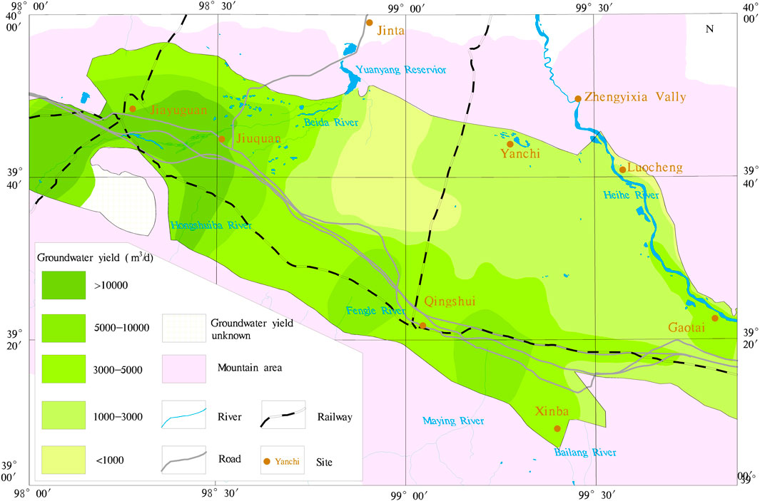
Figure 1. Hydrogeological Map of the Jiuquan Basin. This map illustrates the spatial distribution of aquifer water richness in the Jiuquan Basin. Aquifer yield is classified into five categories: <1000, 1000–3000, 3000–5000, 5000–10000, and >10000 m3/day. Groundwater is primarily concentrated in the piedmont and alluvial plains, particularly along the mountain near the Qilian Mountains. Key geomorphological features, river networks, transportation routes, and administrative boundaries are also marked (Li, 2004; Liu, 2003; Xie et al., 2024; Yang, 2020; Xiong, 2004; Wei et al., 2007; Mi et al., 2016).
In recent decades, researchers have conducted extensive investigations into the hydrogeology of the Jiuquan Basin. Methods including geological surveys, geophysical exploration, hydrochemical analysis, and groundwater modeling have identified key characteristics of the aquifer system. These include vertical stratification and horizontal zonation, recharge primarily from Qilian Mountain snowmelt and atmospheric precipitation, and a general south-to-north flow direction that ends in terminal lakes or through evaporation (He et al., 2011; Wang et al., 2021; Shen, 2008; Zhou et al., 2009). Hydrochemical simulations and stable isotope analyses (δD and δ18O) have revealed slow groundwater movement, strong water-rock interactions, and complex geochemical evolution (Zhang et al., 2005; Zhu et al., 2010; He et al., 2012; Hu et al., 2014; Ren, 2020; Feng et al., 2022; Pan et al., 2002; Zhang et al., 2006). Several studies have also applied numerical models to simulate basin-scale groundwater flow under varying scenarios (Wang, 2007; Wang and Zhou, 2009), providing valuable guidance for groundwater exploitation and ecological conservation (Jia et al., 2008; Yin et al., 2022; Ugural et al., 2024; Qiu et al., 2015; Sang et al., 2025).
Despite these advances, several important knowledge gaps remain. First, the mechanisms governing deep groundwater circulation in the basin are not yet well understood. Second, existing studies have focused primarily on the overall groundwater pattern, while the internal heterogeneity and secondary groundwater flow systems within the basin have not been clearly delineated. Additionally, the connections between different recharge sources, aquifer layers, and groundwater age distributions require further investigation. These limitations constrain the accuracy of regional water resource assessments and the formulation of targeted management strategies.
To address these challenges, this study integrates field hydrogeological investigations, hydrochemical analysis, isotopic tracing (δD, δ18O), and radiocarbon dating (14C) to establish a refined conceptual model of groundwater circulation in the Jiuquan Basin (Figure 2). The research aims to reveal spatial differentiation in groundwater recharge, flow, and age across different geomorphic units and hydrologic zones. By analyzing isotopic patterns and groundwater ages, this study delineates secondary groundwater flow systems and explores their controlling factors. The outcomes are expected to provide a scientific foundation for rational groundwater use and ecological protection, as well as to contribute to broader understandings of groundwater dynamics in arid inland basins.
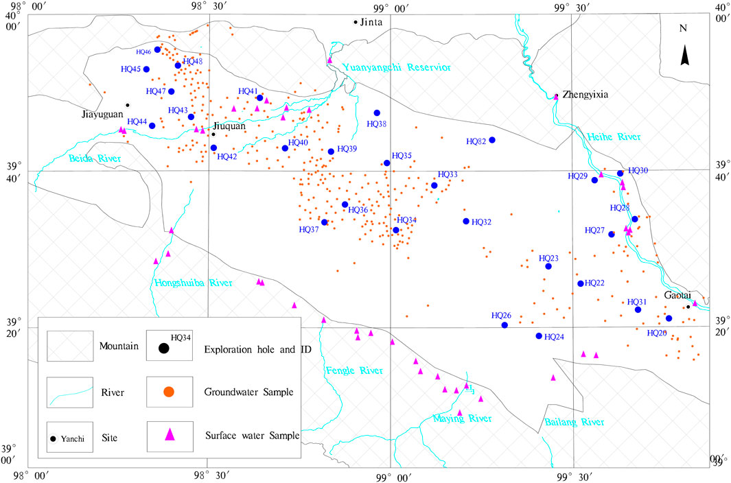
Figure 2. Spatial Distribution of Sampling Points in the Jiuquan Basin. This figure shows the locations of water sampling points used for isotopic (δD and δ18O) and 14C analyses across the Jiuquan Basin. Blue dots represent sampling sites with isotopic data, while purple triangles indicate boreholes where 14C groundwater dating was conducted. Sample identifiers and selected groundwater ages (in years) are labeled. The distribution reflects intensive sampling in key recharge and discharge zones and supports the spatial analysis of groundwater circulation and aging patterns.
2 Materials and methods
This study is based on field data collected from the Jiuquan Basin as part of the 1:50,000 hydrogeological survey conducted within the Heihe River Basin. Water samples were obtained from multiple sources, including river water, reservoir water, spring water, shallow hand-dug wells (typically <20 m depth), medium-depth civil wells (20–150 m), and deep boreholes (>150 m), including those sampled during pumping tests. The sampling sites were spatially distributed across the Jiuquan Basin, with denser coverage in oasis areas and sparser coverage in desert regions, ensuring comprehensive spatial representation.
Deuterium (δD) and oxygen-18 (δ18O) isotopic analyses were performed on all collected samples to trace groundwater sources and identify recharge processes. A total of 439 deuterium-oxygen isotope samples and 45 radiocarbon (14C) samples were analyzed. Isotopic analyses were carried out at the Hydrogeological and Environmental Geological Survey Center of the China Geological Survey with accuracy of ±0.5%, while 14C dating was conducted by Beta Analytic Inc., United States with accuracy of ±0.2pMC. These data provide critical insights into groundwater origin, flow pathways, residence time, and the evolution of hydrogeological processes in the region.
3 Results
3.1 Deuterium-oxygen isotope characteristics
The water samples collected from the Jiuquan Basin include both surface water (rivers, reservoirs, ponds, springs) and groundwater, which is further categorized by depth: shallow (<20 m), intermediate (20–150 m), and deep (150–300 m). Isotopic data (δD and δ18O) indicate significant differences between surface and groundwater groups. Given the strong linear relationship between δD and δ18O, the discussion here primarily focuses on δ18O variation.
The δ18O values for surface water range from −10.8‰ to −3.2‰, exhibiting the widest distribution. Shallow groundwater ranges from −10.7‰ to −6.5‰, intermediate groundwater from −11.9‰ to −7.5‰, and deep groundwater from −11.9‰ to −7.7‰. Notably, the intermediate and deep groundwater have similar isotopic ranges, suggesting comparable recharge sources or residence times. These findings are statistically summarized in Table 1.
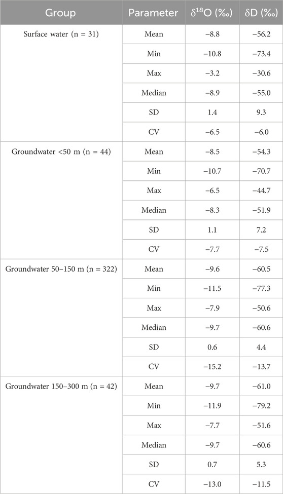
Table 1. Summary statistics of δ18O and δD in surface water and groundwater samples from the Jiuquan basin.
Stable isotope analysis is an effective tool for tracing groundwater sources and recharge pathways (Li et al., 2025; Mondal et al., 2023; Alrehaili et al., 2024; Herrera et al., 2025). As shown in Figure 3, the δD–δ18O plot of surface water reveals that most samples align closely with the Global Meteoric Water Line (GMWL), indicating meteoric origin. Some samples, especially from small reservoirs in the Beidagang River Basin, deviate due to evaporation effects, as shown in the magnified inset (Figure 3b). Differences in δ18O among rivers are also apparent, reflecting varied recharge elevations and hydrological conditions.
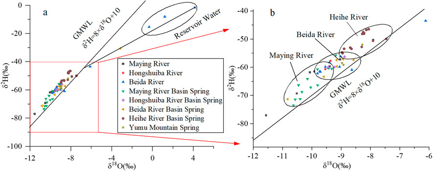
Figure 3. δD–δ18O Relationship for Surface Water Samples in the Jiuquan Basin. (a) All surface water samples, including rivers and springs, generally align with the Global Meteoric Water Line (GMWL), indicating meteoric origin. (b) A magnified view of clustered data points reveals isotope differences among rivers due to elevation and evaporation effects.
Figure 4 presents the δD–δ18O relationships for shallow groundwater (<20 m). Distinct isotope signatures are observed across basins. While groundwater in the downstream area of the Heihe River shows signs of evaporation, other regions—such as the Maying and Beidagang Rivers—retain more depleted isotopic values, indicative of recent recharge and high-elevation sources. Some shallow wells, although geographically near the Heihe River, reflect recharge from adjacent systems such as the Maying River, as inferred from their δ18O signatures.
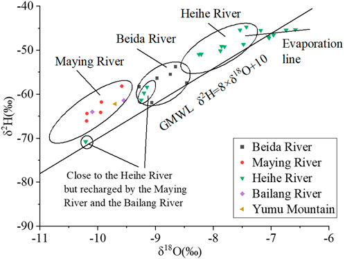
Figure 4. δD–δ18O Relationship for Shallow Groundwater (<20 m). Distinct isotopic signatures across basins indicate varied recharge sources. Some samples near the Heihe River show enriched values due to evaporation, while others reflect upstream recharge from Maying and Bailang Rivers.
Intermediate-depth groundwater samples (20–150 m), displayed in Figure 5, show relatively uniform distributions aligned with the GMWL, suggesting recharge from precipitation. The isotope values of the North Mountain are significantly more negative than those from rivers originating in the Qilian Mountains, indicating that the North Mountain area receives recharge primarily from localized seasonal overland flow rather than southern mountain runoff.
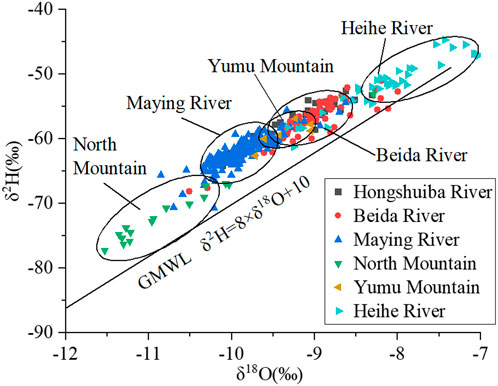
Figure 5. δD–δ18O Relationship for Intermediate Groundwater (20–150 m). Groundwater at intermediate depth shows consistent alignment with the GMWL, reflecting recharge from precipitation. More negative values in the North Mountain suggest localized runoff recharge rather than Qilian-sourced water.
Figure 6 shows that deep groundwater (150–300 m) follows similar patterns to those observed in shallower layers, though local heterogeneities remain. The isotopic similarity across depths in some regions suggests active vertical exchange or uniform recharge conditions.
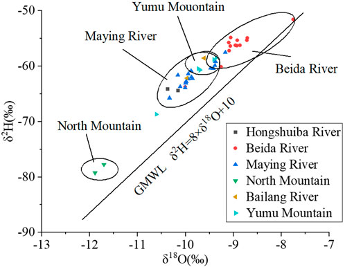
Figure 6. δD–δ18O Relationship for Deep Groundwater (>150 m). Deep groundwater shows similar isotopic signatures to shallower samples, indicating comparable recharge origins and limited isotopic evolution with depth in some zones.
As illustrated in Figures 5, 6, the distribution patterns of D and 18O isotope samples in the groundwater located at the front of North Mountain are markedly distinct from those in the Maying River Basin and Fengle River Basin. This suggests that the groundwater in this area is not sourced from the Maying River or Fengle River. Considering its geographical location and hydrogeological characteristics, it is hypothesized that the groundwater is primarily recharged by seasonal mountain floods originating from Beishan Mountain.
3.2 Radiocarbon (14C) isotope characteristics
Radiocarbon dating (14C) is a fundamental method for estimating groundwater residence time (Li et al., 2024; Meyzonnat et al., 2023; Zha and Mao, 2024). In this study, groundwater samples were collected from boreholes throughout the Jiuquan Basin. Some deep boreholes were equipped with multi-depth pumping installations, allowing for layered sampling and age comparison. The results show that, except for a few samples near the mainstream of the Heihe River (e.g., HQ30), most groundwater samples exhibit ages greater than 5,000 years (Table 2).

Table 2. Radiocarbon (14C) dating results of groundwater samples in the Jiuquan basin.
Figure 7 compares groundwater ages at different depths. The vertical age gradient is expressed as the relative difference between upper and lower sample ages in the same borehole. The analysis reveals that groundwater in the southern part of the basin tends to show minimal age differences between layers, indicating hydraulic connectivity and similar recharge periods. In contrast, the northern and northwestern parts (e.g., Maying, Fengle, and Duanshankou River basins) show significantly larger vertical age differences, suggesting hydraulic separation between aquifer layers and staggered recharge periods.
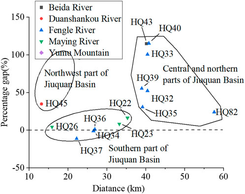
Figure 7. Comparison of Groundwater Age Differences between Upper and Lower Aquifer Layers in the Jiuquan Basin. This figure displays the percentage age difference between deep and shallow groundwater samples in the same borehole, plotted against distance from the mountain or river outlet. Larger differences in the north suggest layered aquifers with weak vertical hydraulic connection, while the southern basin exhibits more uniform recharge.
Figure 8 illustrates the spatial pattern of shallow groundwater ages relative to distance from the mountain or river outlet. Groundwater near the Heihe and Beidagang rivers exhibits younger ages, some less than 2,000 years, due to active recharge. In contrast, groundwater in the central and downstream parts of the Maying and Fengle River basins is considerably older (up to 30,000 years), reflecting limited recharge and slower flow. Some anomalies (e.g., HQ31 and HQ20 near the Yumu Mountain) reflect complex recharge dynamics likely influenced by groundwater inflow from the adjacent Zhangye Basin.
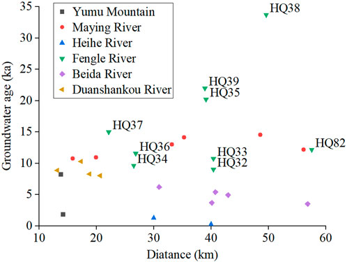
Figure 8. Spatial Variation of Shallow Groundwater Age along Distance Gradient in the Jiuquan Basin. This figure shows the distribution of groundwater age (<50 m depth) in various river basins. Groundwater near the Heihe and Beidagang Rivers is relatively young, while that in the central basin and downstream Maying/Fengle Rivers is significantly older. Complex recharge behavior is noted in the Yumu Mountain.
Figure 9 presents the deep groundwater age distribution. Similar spatial patterns emerge: ages increase along the groundwater flow path in most basins. An exception is observed at HQ82 in the North Mountain, where the deep groundwater age is younger than expected compared to other locations at similar distances. This anomaly may indicate a separate secondary groundwater flow system. If the HQ82 borehole is located in the downstream of the Fengle River, the age of the groundwater at HQ82 should be greater than that at HQ38 and HQ39. However, the actual situation is that the groundwater age at HQ82 is smaller. Considering that HQ82 is located at the foot of the Beishan Mountain, it can be inferred that HQ82 is in another groundwater flow system rather than the Fengle River groundwater flow system.
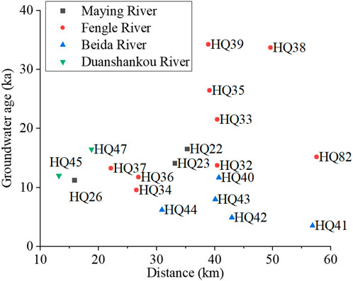
Figure 9. Spatial Variation of Deep Groundwater Age along Distance Gradient in the Jiuquan Basin. Groundwater age at depths >150 m generally increases with distance along flow paths in the Maying and Fengle basins, consistent with expected hydrological behavior. HQ82 appears as an outlier, suggesting that it may belong to a distinct groundwater flow system.
The groundwater age results indicate that along both sides of major rivers, such as the Heihe River and the Beida River, the groundwater tends to be younger. In contrast, the central and northern regions of the basin exhibit older groundwater, suggesting a longer average residence time.
In the areas adjacent to both sides of the Beida River and the Heihe River, the groundwater exhibits relatively young ages and rapid circulation rates, indicating a high degree of renewability. In the western Dunshankou River Basin and the eastern Gaotai area of the Jiuquan Basin, groundwater ages are generally less than 10,000 years, suggesting moderate renewability. In contrast, in the central and northern parts of the basin, groundwater ages are significantly older, reflecting limited renewability. However, extensive land reclamation and intensive agricultural activities are currently being carried out in these regions, with irrigation water primarily sourced from groundwater. These activities are currently disrupting the natural balance between groundwater recharge and discharge. Therefore, agricultural development in these areas should be regulated to mitigate adverse impacts on the groundwater system.
4 Discussion
4.1 Precipitation amount effect on isotopic signatures
The isotopic composition of groundwater across different parts of the Jiuquan Basin reveals a pattern that is inconsistent with the commonly expected altitude effect. Intermediate and deep groundwater samples from the North Mountain display significantly more negative δ18O values than those from the Qilian Mountain-sourced rivers such as the Heihe, Beidagang, Maying, and Hongshuiba. Given that Qilian Mountain is much higher in elevation than North Mountain, one would typically expect more depleted isotopes in the former’s recharge. However, the opposite trend observed here suggests that elevation alone does not govern isotopic variation in this arid region.
Instead, the observed differences are better attributed to the precipitation amount effect. Due to the strong temperature contrasts and large orographic lifting in the Qilian Mountains, the region experiences more intense and frequent precipitation. This leads to a larger fraction of heavy isotopes (18O and D) remaining in the condensed phase and falling as rain, thus enriching the isotopic signature. In contrast, the North Mountain area, being lower in elevation and much drier, generates less precipitation and thus has more depleted isotopic values in its limited groundwater recharge. This suggests that in arid inland basins, especially over distances of less than 100 km, the amount of precipitation and associated condensation dynamics play a more critical role in determining isotope values than elevation alone.
4.2 Local meteoric water line (LMWL) of the Jiuquan basin
To establish a regional isotopic baseline, δD and δ18O data from groundwater samples between 20 and 150 m deep were used to construct the Local Meteoric Water Line (LMWL). After excluding samples affected by evaporation, the least-squares regression yielded the equation: δD = 6.02 × δ18O- 2.5 (R2 = 0.92) (Figure 10). This slope is slightly lower than that of the Global Meteoric Water Line (GMWL), which is consistent with evaporative enrichment typical of arid to semi-arid climates.
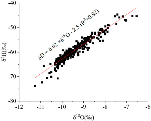
Figure 10. Local Meteoric Water Line (LMWL) in the Jiuquan Basin. The regression line δD = 6.02 × δ18O- 2.5 (R2 = 0.92) was fitted using δD and δ18O data from groundwater at 20–150 m depth. The LMWL slope is lower than the GMWL due to evaporative effects in this arid climate. This line provides a key reference for interpreting recharge sources and isotopic evolution in the basin.
The fitted LMWL closely resembles that of the adjacent Zhangye Basin, where the LMWL slope is 6.76 (Li et al., 2015; Wu et al., 2011). The relatively low slope values in both basins suggest that meteoric precipitation undergoes substantial isotopic fractionation due to evaporation before or during infiltration. The similarity also implies that these regions share broadly comparable climatic influences, even if their recharge mechanisms differ. Overall, the Jiuquan LMWL provides an important reference for interpreting groundwater recharge processes, tracing moisture sources, and distinguishing between evaporative and non-evaporative influences in isotopic datasets.
4.3 Spatial zonation of secondary groundwater flow systems
The spatial distribution of δ18O and δD values, in combination with groundwater dating results and regional geomorphic patterns, enables the delineation of several secondary groundwater flow systems within the Jiuquan Basin. These systems are not only spatially distinct but also hydrogeologically and isotopically unique, reflecting varying recharge sources, residence times, and flow dynamics. The North Mountain system, for example, is characterized by significantly depleted isotopic signatures and relatively young groundwater ages, such as those recorded at HQ82. These traits indicate localized recharge from seasonal runoff rather than distant river systems, confirming it as a separate hydrological entity.
In contrast, the downstream area of the Heihe River includes wells such as HQ29 and HHQ027 that, despite being geographically close to the Heihe channel, share isotope characteristics with the Maying River system. This suggests that local topography and aquifer structure cause the Maying River to dominate recharge in this zone. Similarly, the Yumu Mountain area appears to be influenced by groundwater inflow from the Zhangye Basin rather than by adjacent Jiuquan sources. Its isotopic and stratigraphic features are distinct enough to justify independent classification.
Though some basins such as the Maying and Fengle Rivers are geographically adjacent, differences in isotope profiles and groundwater age gradients reveal separate hydrogeological systems. Even the Duanshankou and Beidagang Rivers, which share similar topographic positions and climate conditions, differ markedly in groundwater residence times and recharge characteristics. These findings highlight the complex and compartmentalized nature of groundwater movement in the basin and emphasize the importance of combining isotopic, chronological, and hydrogeological data to accurately map groundwater systems. The delineation of SGFS enhances the understanding of hydrogeological conditions across different parts of the basin, thereby providing a certain degree of guidance for the sustainable management of groundwater development and ecological conservation.
As shown in Figure 11, the delineation of secondary groundwater flow systems has significantly improved the understanding of recharge and discharge mechanisms within the basin. The Beida River SGFS and the Heihe River SGFS are primarily recharged through channel leakage at the mountain outlets and subsequently flow downstream into the Jinta Basin and Dingxin Valley. The Hongshuba-Hongshan River SGFS, Fengle River SGFS, Maying-Bailang River SGFS mainly receives recharge from river water originating in the southern Qilian Mountains and is predominantly discharged through evaporation and anthropogenic extraction. The Yumu Mountain SGFS also receives recharge from the southern Qilian Mountains but discharges into adjacent groundwater flow systems. The North Mountain SGFS is primarily recharged by seasonal mountain floods from North Mountain and is mainly discharged through evaporation and human exploitation. The Duanshankou River SGFS is recharged by surface water from Beishan and predominantly discharges into the Beida River SGFS.
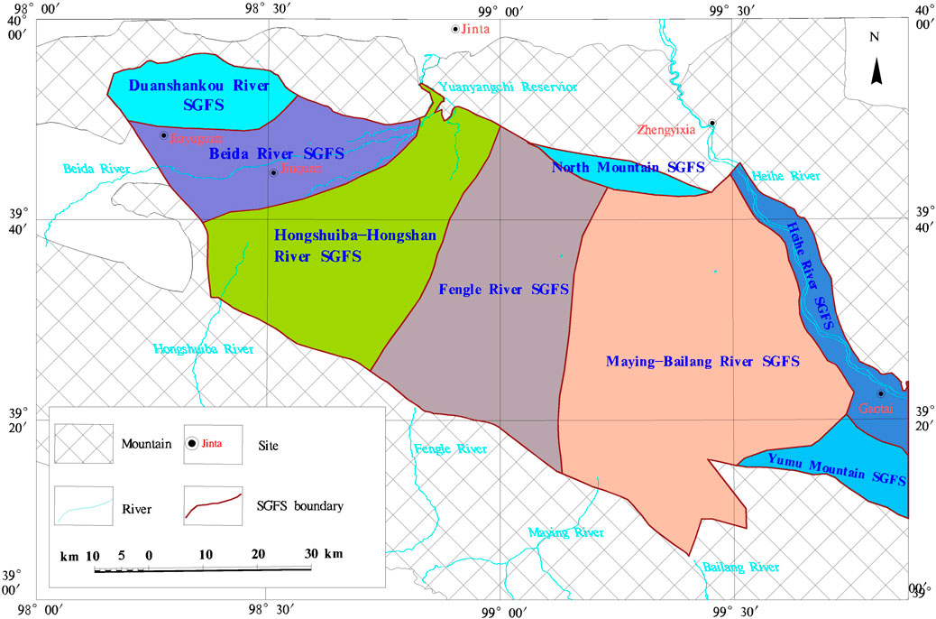
Figure 11. Delineation of Secondary Groundwater Flow Systems in the Jiuquan Basin. This map divides the basin into seven secondary groundwater flow systems based on isotopic composition, groundwater age, topographic features, and river catchments. These include systems associated with the Heihe River, Beidagang River, Duanshankou River, Maying River, Fengle River, Yumu Mountain, and North Mountain. Variations in recharge mechanisms and hydrogeological characteristics justify the classification.
The delineation of groundwater flow systems primarily utilized stable isotopes and radiocarbon (14C) dating. In regions adjacent to major rivers, such as the Beida River and the Heihe River, the classification of groundwater flow systems—namely the Beida River SGFS and Heihe River SGFS—was based on the relatively younger groundwater ages observed in these areas. However, this classification has certain limitations, mainly due to the limited number of available samples, which hinders the precise determination of boundaries between the two systems. Similarly, for the North Mountain SGFS, its existence was inferred from the younger groundwater age detected at the HQ82 borehole, suggesting that it is distinct from the Fengle River and Maying River systems. Nevertheless, due to insufficient sampling, the boundary of the Beishan system remains speculative rather than definitively established. Although the boundaries of these three SGFS may not be entirely accurate, the overall classification still enables the differentiation of distinct flow systems and provides a methodological reference for future theoretical studies.
5 Conclusion
This study systematically investigated the groundwater circulation patterns in the Jiuquan Basin using hydrogeological surveys, stable isotope analysis (δD and δ18O), and radiocarbon (14C) dating. The results confirm that precipitation is the dominant source of groundwater recharge in the basin. Isotopic values exhibit distinct horizontal zonation, reflecting spatial variability in recharge origins. A pronounced precipitation amount effect was observed: groundwater recharged by the Qilian Mountains shows more enriched isotopic signatures than that recharged by the lower North Mountains. A Local Meteoric Water Line (LMWL) was derived from groundwater isotopes (δD = 6.02 × δ18O- 2.5, R2 = 0.92), which provides a critical isotopic baseline for hydrological interpretation in this arid region. Radiocarbon dating revealed that most groundwater has residence times exceeding 5,000 years, with significantly younger ages near active river channels (e.g., the Heihe and Beidagang Rivers) due to river–aquifer interactions. In contrast, central and terminal areas of the basin exhibit older groundwater, indicating slower flow and limited recharge. Based on combined isotope and age data, the basin was hydrologically partitioned into several secondary groundwater flow systems associated with different rivers and geomorphic units, including those of the Beidagang River, North Mountain, Maying River, Fengle River, Hongshuiba, Duanshankou, and Yumu Mountain.
These findings not only deepen the understanding of groundwater recharge and flow mechanisms in an arid inland basin but also provide a scientific basis for regional water resource management and ecological protection. The delineation of multiple secondary flow systems underscores the complex hydrogeological framework and highlights the necessity of localized groundwater evaluation and planning. Moreover, the observed patterns of groundwater age and isotopic signatures offer new insights into recharge timing, flow paths, and hydraulic connectivity across the basin. Future studies should focus on coupling isotope tracing with numerical groundwater flow modeling to simulate spatiotemporal changes under scenarios of climate change and anthropogenic extraction. Expanding monitoring networks and integrating geophysical data may further enhance the precision of groundwater resource assessments, supporting sustainable development in the Hexi Corridor and broader arid regions of northwestern China.
Data availability statement
The raw data supporting the conclusions of this article will be made available by the authors, without undue reservation.
Author contributions
WW: Funding acquisition, Writing – original draft, Investigation, Conceptualization, Project administration, Methodology. SY: Project administration, Funding acquisition, Writing – review and editing. YA: Funding acquisition, Investigation, Writing – review and editing. WL: Funding acquisition, Supervision, Writing – review and editing, Project administration. YC: Writing – review and editing, Methodology, Data curation. XS: Supervision, Investigation, Writing – review and editing. XWu: Writing – review and editing, Methodology, Investigation. HC: Investigation, Conceptualization, Methodology, Writing – review and editing. DY: Data curation, Writing – review and editing, Investigation, Methodology. XWa: Validation, Methodology, Investigation, Writing – review and editing.
Funding
The author(s) declare that financial support was received for the research and/or publication of this article. This work was funded by the Open Fund of Key Laboratory of Groundwater Engineering and Geothermal Resources in Gansu Province (grant No. KLGEGR-2024-04) and Research on Key Technologies for the Construction of Water Resources Investigation and Evaluation System in Inland Drainage Areas under the Synergy of Natural Ecosystem Health and High-Quality Social and Economic Development (grant No. 2024ZRBSHZ019).
Conflict of interest
The authors declare that the research was conducted in the absence of any commercial or financial relationships that could be construed as a potential conflict of interest.
Generative AI statement
The author(s) declare that no Generative AI was used in the creation of this manuscript.
Any alternative text (alt text) provided alongside figures in this article has been generated by Frontiers with the support of artificial intelligence and reasonable efforts have been made to ensure accuracy, including review by the authors wherever possible. If you identify any issues, please contact us.
Publisher’s note
All claims expressed in this article are solely those of the authors and do not necessarily represent those of their affiliated organizations, or those of the publisher, the editors and the reviewers. Any product that may be evaluated in this article, or claim that may be made by its manufacturer, is not guaranteed or endorsed by the publisher.
References
Alrehaili, A. M., Keller, C. K., Moore, B. C., and Boll, J. (2024). Stable isotope hydrology of a polymictic Lake: capturing transience of groundwater interactions. J. Hydrology 639, 131551. doi:10.1016/j.jhydrol.2024.131551
Feng, W., Li, W. P., Shao, X. M., Qi, X. F., and Li, T. (2022). Research on the dynamic characteristics of groundwater and regulation capability of aquifers in the intermediate section of heihe river basin. Hydrogeology and Eng. Geol. 49 (3), 11–21.
He, J. H., Fu, S. J., Ma, J. Z., and Zhang, Q. H. (2011). Groundwater recharge and geochemical evolution in quaternary aquifer of beidahe river watershed. J. Desert Res. 31 (6), 1630–1638.
He, J., Ma, J., Zhang, P., Tian, L., Zhu, G., Edmunds, W. M., et al. (2012). Groundwater recharge environments and hydrogeochemical evolution in the jiuquan Basin, northwest China. Appl. Geochem. 27 (4), 866–878. doi:10.1016/j.apgeochem.2012.01.014
Herrera, C., Gamboa, C., Godfrey, L., Urrutia, J., Jódar, J., Calderón, R., et al. (2025). Using multiple environmental isotopic tracers to investigate groundwater flow and recharge from a mountain block to a basin-fill aquifer in semi-arid central Chile. J. Hydrology 650, 132542. doi:10.1016/j.jhydrol.2024.132542
Hu, Y., Liu, C. K., Lu, Y. H., Liu, J., and Zheng, C. M. (2014). Application of environmental isotopes in understanding hydrological processes of the heihe River Basin. Adv. Earth Sci. 29 (10), 1158–1166. doi:10.11867/j.issn.1001-8166.2014.10.1158
Jia, Y. K., Liu, F. L., Zhang, L., Nie, Z. L., and Shen, J. M. (2008). Recognition of groundwater recharge and flow system in the jiuquan-zhangye basin by means of environmental isotopic tracers, 29(6), 740–744.
Li, F. Q. (2004). Formative mechanics and evolvement of jiuquan basin. Chengdu: Chengdu University of Technology.
Li, J. F., Shi, P. J., Zhu, G. F., He, Y. Q., Liu, Y. F., Tong, H. L., et al. (2015). Characteristics of δ18O in precipitation and moisture transports in the central hexi corridor. Acta Sci. Circumstantiae 35 (4), 947–955.
Li, J., Zhang, Y. K., Zhou, Z., Guo, Y., Zhao, J., and Liang, X. (2024). Using multiple isotopes to determine groundwater source, age, and renewal rate in the beishan preselected area for geological disposal of high-level radioactive waste in China. J. Hydrology 629, 130592. doi:10.1016/j.jhydrol.2023.130592
Li, Y., Duvert, C., Xu, P., and Bian, J. (2025). Contrasting origins of spring water in a ‘water tower’of northeast Asia: evidence from stable isotopes and tritium. J. Hydrology 652, 132661. doi:10.1016/j.jhydrol.2024.132661
Liu, S. Y. (2003). Study on pattern of rational-utilize and circle-change of the groundwater in the inland basins of northwest China. Beijing: Chinese Academy of Geological Sciences.
Meyzonnat, G., Musy, S., Corcho-Alvarado, J. A., Barbecot, F., Pinti, D. L., Purtschert, R., et al. (2023). Age distribution of groundwater in fractured aquifers of the st. Lawrence lowlands (canada) determined by environmental tracers (3H/3He, 85Kr, SF6, CFC-12, 14C). Hydrogeology J. 31 (8), 2139–2157. doi:10.1007/s10040-023-02671-0
Mi, L., Xiao, H., Zhang, J., Yin, Z., and Shen, Y. (2016). Evolution of the groundwater system under the impacts of human activities in middle reaches of heihe river Basin (northwest China) from 1985 to 2013. Hydrogeology J. 24 (4), 971.
Mondal, S. K., Bharti, R., and Kuma, S. (2023). Spatio-temporal variations in oxygen and deuterium isotope of different water sources in Sikkim himalayas: an understanding towards regional scale basin hydrology. J. Hydrology 621, 129613. doi:10.1016/j.jhydrol.2023.129613
Pan, S. B., Wang, Z. J., and &Tian, W. (2002). Discussions on numerical modeling methods of groundwater system in hexi corridor. Hydrogeology Eng. Geol.
Qiu, S., Liang, X., Xiao, C., Huang, H., Fang, Z., and Lv, F. (2015). Numerical simulation of groundwater flow in a river valley basin in Jilin urban area, China. Water 7 (10), 5768–5787. doi:10.3390/w7105768
Ren, X. H. (2020). Study on hydrochemical characteristics and evolution mechanics of groundwater in the jiuquan east basin. Jinan: Shandong University of Science and Technology.
Sang, L. Y., Guo, W., Zhang, J. W., Liu, Y. X., Zhang, T. K., Zhang, Z. Q., et al. (2025). Current status, challenges, and future directions of research on hydrological processes, water environment, and water resources in the urban earth's critical zone. Earth Sci. Front. 32 (3), 445–461.
Shen, J. M. (2008). The cause of groundwater salinization and paleoclimate characteristics in yanchi area of jiuquan east basin. [beijing]. Chin. Acad. Geol. Sci.
Ugural, M. N., Ozyilmaz, M. R., and Burgan, H. I. (2024). Life cycle assessment analysis based on material selection in sustainable airport buildings. Buildings 14, 2728. doi:10.3390/buildings14092728
Wang, G. (2007). Groundwater system numerical simulation of Jiuquan basin. Lanzhou: Lanzhou University.
Wang, X. S., and Zhou, J. (2009). Advances in numerical modeling of groundwater flow in heihe river basin. Geotechnical Investigation and Surv. 37 (9), 35–38.
Wang, W. X., Li, W. P., Cai, Y. M., An, Y. H., Shao, X. M., Wu, X., et al. (2021). The hydrogeochemical evolution of groundwater in the middle reaches of the heihe river basin. Earth Sci. Front. 28 (4), 184–193.
Wei, G. X., Wang, D. J., Wang, G., Li, C. B., and Zhu, F. (2007). Application of GIS and FEFLOW to numerical simulation of groundwater system in jiuquan east basin. J. Lanzhou Univ. Nat. Sci. 43 (6), 1–6.
Wu, J. K., Yang, Q. Y., Ding, Y. J., Ye, B. S., and Zhang, M. Q. (2011). Variations and simulation of stable isotopes in precipitation in the heihe river basin. Environ. Sci. 32 (7), 1857–1866.
Wu, B., Zheng, Y., Wu, X., Tian, Y., Han, F., Liu, J., et al. (2015). Optimizing water resources management in large river basins with integrated surface water-groundwater modeling: a surrogate-based approach. Water Resour. Res. 51 (4), 2153–2173. doi:10.1002/2014wr016653
Xie, W., Yin, D., Zhao, Y., Wu, X., Wang, W., Wang, M., et al. (2024). Identification of the groundwater flow system in the middle reaches of heihe river basin (northwestern China) based on stratified groundwater exploration technology. Hydrogeology J. 32 (1), 241–252.
Xiong, W. (2004). Reasonable water resources allocation research of middle-west river system of heihe river. Xi’an: Xi'an university of technology.
Yang, Y. B. (2020). Study on the evolution of groundwater in Jiuquan east Basin. Lanzhou: Lanzhou University.
Yin, D. C., Wu, X., Cui, H. Q., Wang, W. X., and Wang, X. Y. (2022). Temperature field and dynamic type of shallow groundwater in the northwest inland basin: a case study of the jiuquan east basin. Bull. Geol. Sci. Technol. 41 (1), 193–202.
Zha, X., and Mao, X. (2024). A method for groundwater 14C age correction accounting for mixing with young and old groundwaters: application to an alluvial aquifer in the jianghan plain, China. Hydrogeology J., 1–17.
Zhang, G. H., Nie, Z. L., Xie, Y. B., Chen, Z. Y., Cheng, X. X., Shen, J. M., et al. (2005). Isotopic characteristics of groundwater and its renewal in the plain area of western Gansu. Geol. Bull. China 24 (2), 149–155.
Zhang, G. H., Chen, Z. Y., Nie, Z. L., Liu, S. Y., Zhang, C. Y., Shen, J. M., et al. (2006). Isotopic characteristics of groundwater and its response to paleoclimatic variation in heihe river basin. Acta Geosci. Sin. 27 (4), 341–348.
Zhou, K. P., Ma, J. Z., Wei, G. X., and Zhu, X. F. (2009). Geochemical characteristics and evolution of groundwater in Jiuquan-Jin Basin. J. Lanzhou Univ. Nat. Sci. 45 (1), 31–36.
Keywords: Jiuquan basin, groundwater circulation pattern, deuterium-oxygen isotopes, 14C, local meteoric water line (LMWL)
Citation: Wang W, Yu S, An Y, Li W, Cai Y, Shao X, Wu X, Cui H, Yin D and Wang X (2025) Investigation of groundwater circulation models in the Jiuquan Basin. Front. Environ. Sci. 13:1667344. doi: 10.3389/fenvs.2025.1667344
Received: 17 July 2025; Accepted: 22 September 2025;
Published: 30 September 2025.
Edited by:
Josef Křeček, Czech Technical University in Prague, CzechiaReviewed by:
Halil Ibrahim Burgan, Akdeniz University, TürkiyeKailiang Zhao, Northwest University, China
Copyright © 2025 Wang, Yu, An, Li, Cai, Shao, Wu, Cui, Yin and Wang. This is an open-access article distributed under the terms of the Creative Commons Attribution License (CC BY). The use, distribution or reproduction in other forums is permitted, provided the original author(s) and the copyright owner(s) are credited and that the original publication in this journal is cited, in accordance with accepted academic practice. No use, distribution or reproduction is permitted which does not comply with these terms.
*Correspondence: Wenxiang Wang, aGl3YW5nd2VueGlhbmdAMTI2LmNvbQ==