 Xiao Shi
 Ruyi Yang
 Waheed Ullah
- 1Meteorological Services Center, Jiangsu Meteorological Bureau, Nanjing, China
- 2Public Meteorological Service Center, China Meteorological Administration, Beijing, China
- 3Rabdan Academy Abu Dhabi, Abu Dhabi, United Arab Emirates
Accurate and spatially continuous soil moisture data are essential for applications including numerical weather prediction, hydrological forecasting, and data assimilation. This study evaluates the global ERA5 reanalysis soil moisture (SMERA5) and Essential Climate Variable (ECV) satellite-derived soil moisture (SMECV) against in situ measurements from 2013 to 2015 in Jiangsu Province, China. Five evaluation indices accuracy metrics and Triple collocation methods are used in this study. Taking SMin-situ as the reference, the SMERA5 outperforms the SMECV in terms of correlation coefficient (0.56 for SMERA5 and 0.42 for SMECV) and Triple Collocation (TC) errors (0.01 m3 m-3 for SMERA5 and 0.025 m3 m-3 for SMECV). However, the SMECV can better characterize the soil moisture with smaller random differences (ubRMSD = 0.045 m3 m-3 for SMECV and 0.052 m3 m-3 for SMERA5relative to the SMin-situ data. Both SMECV and SMERA5 exhibit consistent spatial patterns across seasons, although with notable magnitude differences. These two products effectively capture in situ soil moisture (SMin-situ) temporal dynamics in the northern region, while larger discrepancies occur in the southern region. In addition, we evaluate these products from the perspective of soil moisture sensitivity to precipitation. Results show that SMERA5 data more effectively capture soil moisture response to heavy precipitation events than SMECV. Overall, SMERA5 demonstrates superior performance in temporal correlation and precipitation sensitivity, whereas SMECV excels in minimizing random errors. Both datasets exhibit uncertainties linked to sensor limitations and model parameterization, suggesting targeted improvements (e.g., multi-sensor fusion, bias correction) could enhance their reliability.
1 Introduction
Soil moisture is an essential component of the surface energy balance that influences sensible and latent heat fluxes. Changes in soil moisture exert feedbacks through these energy fluxes and evapotranspiration, linking land surface process to boundary layer and upper troposphere through complex interactions (Dorigo et al., 2017; Hagan et al., 2025; Miralles et al., 2014). Applications of soil moisture include the characterization of land-atmosphere interactions, hydrological analysis, flooding and drought monitoring, and weather forecasting (Jia et al., 2020; Zhang et al., 2021).
In-situ observation provides accurate records of soil moisture (An et al., 2016; Dorigo et al., 2015). In China, soil moisture observations are obtained through gravimetric and Frequency Domain Reflectometry (FDR) techniques (Dorigo et al., 2011), both of which are widely used globally. The FDR provides better temporal resolution compared to the gravimetric technology, and has therefore been widely used in China (An et al., 2016). Though in situ observation can provide accurate measurements of soil moisture at point scale, it is limited by the density and spatial distribution of stations and cannot adequately capture the detailed spatial variations (Hagan et al., 2020).
Remote sensing has emerged as a critical observational tool for soil moisture monitoring, offering spatially continuous data through both active and passive microwave techniques (Lal et al., 2022; Zou et al., 2021). Active remote sensing methodologies (Bartalis et al., 2007; Dharssi et al., 2011), rely on backscattering principles to deduce surface conditions. In contrast, passive systems measure the natural emissions emanating from soil surfaces (Shellito et al., 2016). The recent strides in passive sensing technology have been largely propelled by satellite missions. Notably, the European Space Agency’s Soil Moisture and Ocean Salinity (SMOS) satellite (Kerr et al., 2012; Kang et al., 2016) and the Advanced Microwave Scanning Radiometer-Earth Observing System (AMSR-E) on board NASA’s Aqua satellite have played pivotal roles. These passive products are renowned for their high accuracy; however, their spatial resolution remains relatively coarse, which is a notable limitation. On the other hand, active microwave systems have achieved remarkable operational success. The Soil Moisture Active Passive (SMAP) mission launched by NASA (Entekhabi et al., 2010) stands as a widely adopted active product, further enhanced by the Advanced Scatterometer (ASCAT) on MetOp satellites. ASCAT is capable of providing high-resolution spatiotemporal data that effectively capture the dynamics of global land surfaces. Nevertheless, active systems encounter challenges in operational scalability, primarily due to their susceptibility to surface interference, the complexity of their algorithms, and their limited global coverage. To overcome these limitations, the ESA Climate Change Initiative (CCI) Soil Moisture product (SMECV) ingeniously integrates multi-sensor data from both active and passive systems. By synergizing the complementary strengths of different sensor types, this product achieves enhanced representativeness, a claim that has been substantiated through in situ comparisons (Dorigo et al., 2017; Yuan et al., 2020; Zhu et al., 2019). According to Ma et al. (2019), ESA CCI and SMAP products outperformed SMOS and AMSR2 products over the world, exhibiting slightly smaller ubRMSE and bias. In the specific context of the Yellow River Basin in China, Lou et al. (2018) reported a consistent agreement between in situ measured soil moisture (SMin-situ) and SMECV regarding interannual variations and long-term drying trends observed from 1998 to 2010.
Reanalysis datasets also provide gridded soil moisture estimates by integrating observations from multiple platforms. These include NASA’s Modern-Era Retrospective Analysis for Research and Applications (MERRA) (Rienecker et al., 2011), the NCEP-National Center for Atmospheric Research (NCAR) Reanalysis Project (NNRP) (Kistler et al., 2001) and the European Centre for Medium-Range Weather Forecasts (ECMWF) Interim Reanalysis (SMERA-Interim) (Dee et al., 2011). In 2017, ECMWF released its new ERA5 (SMERA5) global atmospheric and land-surface reanalysis with hourly temporal resolution at 0.28125 spatial resolution (Hersbach et al., 2020). The ERA5-Land dataset incorporates major upgrades achieving higher spatiotemporal resolution (Albergel et al., 2018). Multiple studies have evaluated these reanalysis datasets’ performance in capturing soil moisture dynamics (Kokkalis et al., 2024; Li et al., 2020). Peng et al. (2015a) compared SMERA-Interim with SMOS and AMSR-E data in southwest China, finding it accurately captured large-scale dynamics and seasonal variations. Dong et al. (2022) further assessed SMERA-Interim against SMECV and the Noah land surface model using Tibetan Plateau in situ data, demonstrating SMERA-Interim ‘s superior performance among all evaluated products.
Both SMECV and SMERA-Interim products are recognized as reliable soil moisture products, with extensive evaluations conducted across diverse regions (Hagan et al., 2020; Ullah et al., 2018; Zeng et al., 2015). However, evaluations of SMERA5 remain limited due to its recent release. In addition, eastern China lacks robust assessments owing to sparse in situ observations. Jiangsu Province—a critical economic hub and grain-producing area—exhibits intense land-atmosphere interactions through its summer monsoon precipitation band, yet the mechanistic role of soil moisture in modulating local atmospheric processes is poorly quantified. Given the demand for precise soil moisture data to support agricultural and climate research, this study selects Jiangsu as the target region. We validate ERA5 reanalysis data (SMERA5) and SMECV satellite products against in situ measurements, assessing their accuracy and reliability. The study area, datasets used and methodology are presented in Section 2, the results are presented in Section 3, discussions are presented in Section 4, and conclusions are presented in Section 5.
2 Materials and methods
2.1 Study area
Jiangsu Province, located in eastern China, is among the nation’s most developed regions. It spans 30°45′-35°20′ N and 116°18′-121°57′E, covering approximately 107,200 km2. The region experiences a dominant East Asian Monsoon climate, with mean annual precipitation of ∼1,020 mm—over 50% occurring during summer (Wang and Chen, 2012). Mean annual air temperature is ∼15.3 °C, closely tracking the hydrological cycle. Precipitation variability significantly drives soil moisture dynamics at seasonal and interannual scales. Recent studies further emphasize climate change impacts on regional hydrology, underscoring the need for precise spatiotemporal monitoring of soil moisture (Parinussa et al., 2018; Yin et al., 2016).
The topography of Jiangsu Province is characterized by flat terrain with low hills in the western and southern parts (Figure 1). Based on these physiographic divisions, three representative areas were selected in the northwest (NW), northeast (NE), and southeast (SE) sectors of the study area (Figure 1). The spatial attributes of these areas are categorized in Table 1 according to the Köppen-Geiger climate classification system (Chen et al., 2017).
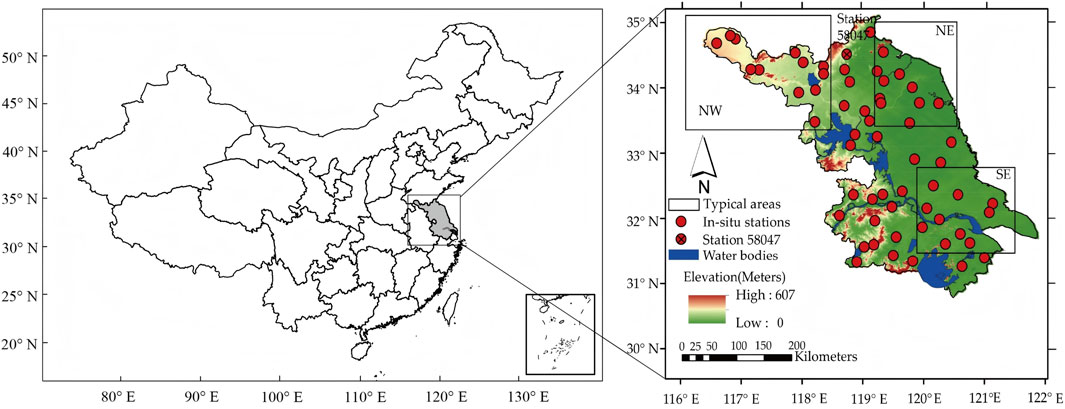
Figure 1. Topography of the Jiangsu Province and the selected regions for temporal analysis (Typical areas are shown as squared areas i.e. NW, NE, SE and typical station 58047 is shown as Red dots).
Table 1. Specifications of three typical areas used in this study.
2.2 Datasets
2.2.1 Satellite-derived soil moisture
The European Space Agency (ESA) Climate Change Initiative (CCI) soil moisture (SMECV) product is employed for validation. Version 3.2 integrates passive microwave sensors (e.g., SMOS, AMSR-E) and active radar systems (e.g., Sentinel-1), achieving soil moisture retrievals down to 5 cm depth with unprecedented spatial-temporal consistency (Dorigo et al., 2017). SMECV consists of three surface soil moisture datasets: the active data derived from scatterometers, the passive data derived from radiometers, and the combined data that merges both. In this study, we use the combined soil moisture daily product with a spatial resolution of 0.25° for the period of 2013–2015 (Gruber et al., 2019).
2.2.2 ERA5 reanalysis soil moisture
ERA5 (SMERA5) is the fifth generation global atmospheric and land-surface reanalysis product developed by the ECMWF (European Centre for Medium-Range Weather Forecasts), covering the period from 1950 to near real time. Compared to its predecessor (ERA-Interim reanalysis dataset), ERA5 incorporates more satellite-based data and offers considerably higher spatial and temporal resolutions. Hourly reanalysis fields are available at a horizontal resolution of 0.28125° (Albergel et al., 2018).
SMERA5 provides soil moisture estimates at four depth layers: 0–7 cm, 8–28 cm, 29–100 cm, and 101–289 cm, respectively. Given that satellite soil moisture products typically retrieve soil moisture at the top ∼5 cm depth from the data of C and L bands (An et al., 2016), we use the SMERA5 of the top layer (0–7 cm) during 2013–2015 to match the satellite-based SMECV product.
2.2.3 In-situ observations
The hourly in situ soil moisture observations (SMin-situ) from 60 stations during 2013–2015 are obtained from the Jiangsu Meteorological Information Center. The spatial distribution of these stations (marked as red solid dots) is shown in Figure 1. Measurements are collected using Frequency Domain Reflectometry (FDR) sensors, which are considered more accurate and physically less destructive than the traditional gravimetric technique (Dorigo et al., 2010; 2011). Soil moisture is recorded at an interval of 10 cm depth down to the depth of 1 m. In this study, only the observations of the top layer (0–10 cm) are used to evaluate the remotely sensed and reanalysis soil moisture products.
2.3 Methods
2.3.1 Accuracy metrics
The accuracy of soil moisture estimates is conventionally evaluated by comparing them against in situ observations, allowing for the computation of performance metrics such as the correlation coefficient (R), unbiased root-mean-square difference (ubRMSD) and bias (Albergel, Brocca, et al., 2013; Albergel, Dorigo, et al., 2013).
To quantify pattern similarity, the Pearson’s correlation coefficient is calculated (Equation 1):
where, SMe denotes as the estimate product of soil moisture SMECV or SMERA5 in this study, n is the time step and N is the length of the data.
To quantify deviation in magnitude from the in situ observations, both root-mean-square difference (RMSD) and ubRMSD are calculated. RMSD represents the absolute error, while ubRMSD represents the centered error, which removes the bias component and is considered more appropriate for assessing the relative error of soil moisture dynamic range. Due to potential systematic errors arising from the different depths across datasets, more emphasis is placed on ubRMSD rather than RMSD in this study.
RMSD is calculated as (Equation 2):
ubRMSD is calculated as Equation 3:
Bias, indicating the average direction of the deviation from observed values, is calculated as Equation 4:
where, a positive bias indicates an overestimation of soil moisture measurements, while a negative bias implies an underestimation (Albergel et al., 2010).
Additionally, normalized standard deviation (SDV) is calculated to evaluate the relative amplitude in the pattern variations (Equation 5),
where, σe and σin-situ are the standard deviations for estimate product of soil moisture and in situ observations.
2.3.2 Triple collocation
The validation of gridded SM products is usually carried out by in situ data (Xu et al., 2021). In-situ soil moisture is measured directly and usually represents the soil moisture condition of the site being measured or homogeneous surroundings. However, the number of in situ sites is limited and is unable to be expanded on a large spatial scale. As a complement, the triple collocation (TC) method, which is a kind of mathematics-based error analysis approach (Yang et al., 2022), has been developed for SM evaluation when in situ data are not available (Xu et al., 2021; Yu et al., 2023). Recent advances in triple collocation (TC) method has facilitated the assessment of root means square error while simultaneously solving for systematic differences across collocated dataset (Scipal et al., 2008). In this study, we constructed triplets based on daily SMECV, SMERA5 and SMin-situ data from 1 January 2013 to 31 December 2015 (Dorigo et al., 2010).
Suppose the true value of soil moisture is θ. Three sets of independent observation data are x, y, and z, which satisfy the following linear model (Equation 6):
where constants αi and βi represent calibration constants and ϵi denote the residual error of the estimates.
By eliminating the truth value θ, the unbiased estimates of the error variances for the three sets of data are derived (Equations 6–9):
where ⟨.⟩ denotes the mean value in terms of time or space.
It is important to note that applying triple collocation to soil moisture anomalies provides complementary insights into dataset performance. Anomaly-based approach offers more accurate information on the product’s ability to capture single events of drying and wetting (e.g., due to rain-fall). Moreover, anomalies are insensitive to systematic bias that may exist between satellite retrievals and climate model simulations (Lei et al., 2015).
In this study, each soil moisture estimate is decomposed into its climatological mean and anomaly components. Mean values of the seasonal climatology are calculated using a moving window averaging of multiyear data with a 31-day window (Crow and Van Den Berg, 2010; McColl et al., 2014). The difference between the climatology and the original data can be treated as the anomaly components. Many studies have demonstrated the effectiveness of this approach before applying Triple Collocation (Parinussa et al., 2012).
3 Results
3.1 Overall accuracy
Figure 2 shows the Taylor Diagram for daily SMECV and SMERA5 data against SMin-situ across the three typical areas during 2013–2015. In the Taylor Diagram, the standard deviation (SDV) is normalized as the ratio of the standard deviation of the estimates relative to SMin-situ (Taylor 2001).
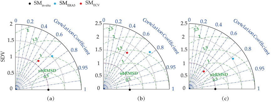
Figure 2. Taylor diagram showing comparison of daily soil moisture variation for three typical areas: (a), (b), (c) represent typical area NW, NE, SE respectively.
As depicted in Figure 2, the SDV of SMERA5 data (ranging from 1.5 to 2.3) is consistently higher than that of SMECV data (ranging from 0.8 to 1.6) across the three regions, especially in northeast area. This indicates that SMERA5 data exhibit greater magnitude variations compared to SMin-situ data in these areas. Systematic deviations between the SMERA5 product and the in situ observations could not be neglected, and a better consistency is achieved when deviations are reduced in the northwest area. Similarly, the ubRMSD for SMECV (ranging from 0.8 to 1.4 m3 m-3) is lower than that for SMERA5 (ranging from 1.2 to 1.6 m3 m-3). Regarding the correlation coefficient, SMERA5 demonstrates a relatively higher correlation with SMin-situ data across the three regions, with values approximately ranging from 0.72 to 0.82, whereas SMECV data show correlation coefficients ranging from about 0.53 to 0.63.
Generally, the southern region (SE) outperforms northern regions (NW, NE) in both R and ubRMSD for both products. It is noteworthy that the regional differences among all indicators, as displayed in the Taylor Diagram, are particularly pronounced in the SE region. This performance disparity in the SE can be attributed to its unique climate; the prevailing easterly winds from the Pacific Ocean result in significant temperature fluctuations, which in turn cause substantial variations in soil moisture at that location. Additionally, the SE region receives more precipitation and solar energy flux than the northern regions, primarily influenced by the Meiyu Belt and its humid climate. Given that the mechanisms governing precipitation are well-represented in reanalysis systems and satellite retrieval algorithms (Ullah et al., 2018), precipitation is likely a key factor influencing soil moisture performance and will be further discussed in Section 4.
3.2 Spatial characteristics of accuracy
3.2.1 Daily scale
3.2.1.1 Temporal variations
In this section, we have derived Pearson’s correlations coefficient (R) of the SMECV and the SMERA5 data against the SMin-situ data respectively using daily data from 2013 to 2015 as shown in Figure 3. Since only 3 years of daily values are calculated, which is rather limited, however, we are still able to capture the dynamic variability of soil moisture due to its seasonal March from one season to another season.
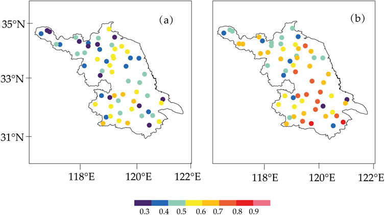
Figure 3. The correlation coefficients of (a) the SMECV and (b) the SMERA5 data against the SMin-situ data respectively from 2013 to 2015.
The correlation coefficients between SMECV and SMin-situ data appear to be high with R > 0.5 over 1/3 of the study area (Figure 3a). Correlation coefficients over northern especially northwest area (R < 0.4) are relatively lower than middle and southern area. An increase in R value over middle area and a further increase over southern area are observed. This demonstrates that SMECV performs better over southern and middle area than northern area.
The SMERA5 data (Figure 3b), are in remarkable agreement with the SMin-situ data in most areas of the Jiangsu province with correlation coefficients higher than 0.6, suggesting significant consistency in terms of their seasonal dynamics. This distribution is particularly strong in southern area, where they show correlation coefficients higher than 0.7 or even 0.8. Increases in R value are also observed from north to the middle part that more stations with R > 0.5 are found.
Thus, we can conclude that both SMECV product and SMERA5 product over study area are able to reproduce the temporal pattern of SMin-situ data and the SMERA5 data performs better than the SMECV data, in terms of the day-to-day variations. In addition, the consistent spatial pattern and relatively better performance for two products over southern area than north should be paid enough attention. This phenomenon is especially strong for SMERA5, R values > 0.7 are mainly located over the southern area. As we know, the NDVI over northern area are mainly larger than southern area, which ranges from 0.75 to 1. From Hagan et al. (2020) results, we known that the performance of LSM dropped over very dense regions (NDVI>0.65), hence we can get the similar conclusion that NDVI value may influence the SMECV and the SMERA5 data over northern areas where dense vegetation located. In addition, the variation in correlation from north to south is mainly because of higher temperature, together with enhanced evaporation in southern area (Hagan et al., 2020; Lou et al., 2018).
3.2.1.2 Bias and ubRMSD spatial distribution
Figures 4a,b shows the biases of the SMECV and the SMERA5 data against the SMin-situ data, computed from the daily observations during 2013–2015. On the other hand, it has been widely acknowledged that the SMin-situ data is subjected to certain uncertainties that can be describe as those due to its retrieval such as depth, sensor placement, and installation, and its point scale representation of a small area, which does not depict a clear picture of large scale soil moisture variability (Ullah et al., 2018; Wu et al., 2016). To show a clear picture of soil moisture dynamics with reduced impacts of such uncertainties, the ubRMSD of the SMECV and the SMERA5 data are also shown in Figures 4c,d.
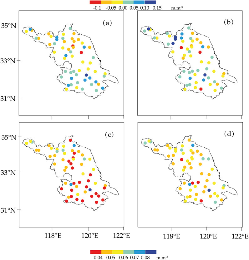
Figure 4. Station scale biases of (a) the SMECV and (b) the SMERA5 and ubRMSD of (c) the SMECV and (d) the SMERA5 against the SMin-situ data over Jiangsu province.
In Figure 4a, it appears negative bias with value < -0.1 m3 m-3 are found over northern and central area, especially over the central area, demonstrating the underestimation of SMECV over these areas. An overestimation reaching 0.15 m3 m-3 is observed over the southern area. For ubRMSD, data of SMECV (Figure 4c) shows larger ubRMSD over the northern areas, ranging from 0.05 to 0.08 m3 m-3, while the values are considerably reduced to less than 0.05 m3 m-3 over the central and southern areas, reaching the minimum value in the southern area, with a regional average value of 0.045 m3 m-3.
For SMERA5 data (Figure 4b), more stations with overestimation are found over northern area except for stations over the northwest region that underestimation are found (<0.1 m3 m-3). In addition, more stations with underestimation are found over southern area. Though SMERA5 data ubRMSD (Figure 4d) also have similar spatial distribution, we can see a significant increase in ubRMSD value of SMERA5 data. The number of stations with ubRMSD <0.05 m3 m-3 largely reduced, especially over the central and southern area. The ubRMSD over the entire area ranging from 0.04 to 0.06 m3 m-3, only few stations less than 0.04 m3 m-3 are located over southwest area. In average, the ubRMSD of SMERA5 is about 0.052 m3 m-3.
In general, the biases of two products are higher in southern-east, north and less in eastern and central parts. In addition, both data of SMECV and SMERA5 have larger ubRMSD over the northern areas; and over the southern areas the ubRMSD of both data are considerably reduced except for a few stations. In comparison to correlation, the regions where the correlation is higher, the biases and ubRMSD are also higher, and on the contrary the regions with smaller correlation have less biases and ubRMSD especially for SMERA5. We can see that the SMECV and SMERA5 data have considerable discrepancies regarding their interannual variations and the associated errors; and, such discrepancies may vary with regions. This phenomenon could be explained by the relatively rough terrain, close to water bodies, or densely vegetated over southern area (Hagan et al., 2019; Holmes et al., 2009). Human induced alteration of land cover may cause this discrepancy in modelled and remotely sensed soil moisture data (Ullah et al., 2018), since southern and northern area are under different developing speed in Jiangsu. However, exploring these reasons is beyond the scope of current study. In addition, the SMECV data appears to have relatively smaller bias and ubRMSD than the SMERA5 data across the Jiangsu Province. Therefore, the SMECV data can better characterize the soil moisture with smaller bias and random differences.
3.2.1.3 TC errors
The results of the error estimation suggest that both SMECV and SMERA5 data are featured by a relatively low error, which are shown in Figure 5. Most stations with SMECV TC error (Figure 5a) less than 0.03 m3 m-3, and SMECV TC error larger than 0.03 m3 m-3 can be frequently found over the southern area. For SMERA5 TC error (Figure 5b), the magnitude is largely reduced to less than 0.02 m3 m-3 and seems evenly distributed over the entire area.
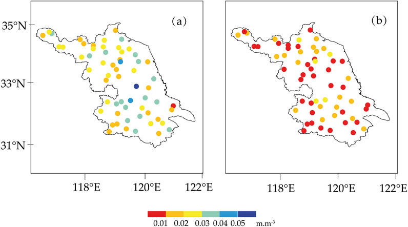
Figure 5. Station scale TC error (a) SMECV and (b) SMERA5 over Jiangsu.
Since TC error best characterizes the intrinsic disability of TC triplets’ datasets to capture the soil moisture value, SMERA5 data substantially lower TC bias value illustrate the superiority of SMERA5 data with smallest error relative to truth. In addition, the lower SMERA5 TC errors also manifest the stronger capability than the SMECV data in catching the drying and wetting events, which is found in the study of climate and model assimilation. The mean regional TC error is 0.025 m3 m-3 for the SMECV, and 0.01 m3 m-3 for the SMERA5. The average TC errors calculated for SMERA5 in this study is reasonablyy lower than those global average TC errors of SMERA-Interim (0.02 m3 m-3) obtained by Scipal et al. (2010) for a combination of the ERS-2 scatterometer (0.028 m3 m-3), the TMI radiometer (0.046 m3 m-3) and SMERA-Interim (0.018 m3 m-3) calculated by Dorigo et al. (2017) for a combination of the ASCAT (0.017 m3 m-3), the AMSR-E (0.019 m3 m-3) soil moisture.
3.2.2 Seasonal scale
Figure 6 shows the spatial patterns of SMin-situ, SMECV and SMERA5 data in different seasons, namely, winter (December-February), spring (March-May), summer (June-August) and autumn (September-November) derived for 2013–2015. In winter season, the SMin-situ soil moisture exhibited a distinct dipole pattern with minimum soil moisture values in the north (< = 0.32 m3 m-3), that gradually reaches to maximum (< = 0.35 m3 m-3 values in the central part and a slight decrease (< = 0.32 m3 m-3) afterwards in magnitude is obvious. Alike pattern is obvious in SMECV that is consistent with SMin-situ in terms of spatial soil moisture variation from north to south. The SMERA5 soil moisture generally exhibited similar pattern as observed for the in situ and remotely sensed products, which however appeared to overestimate both observed and remotely sensed soil moisture product.
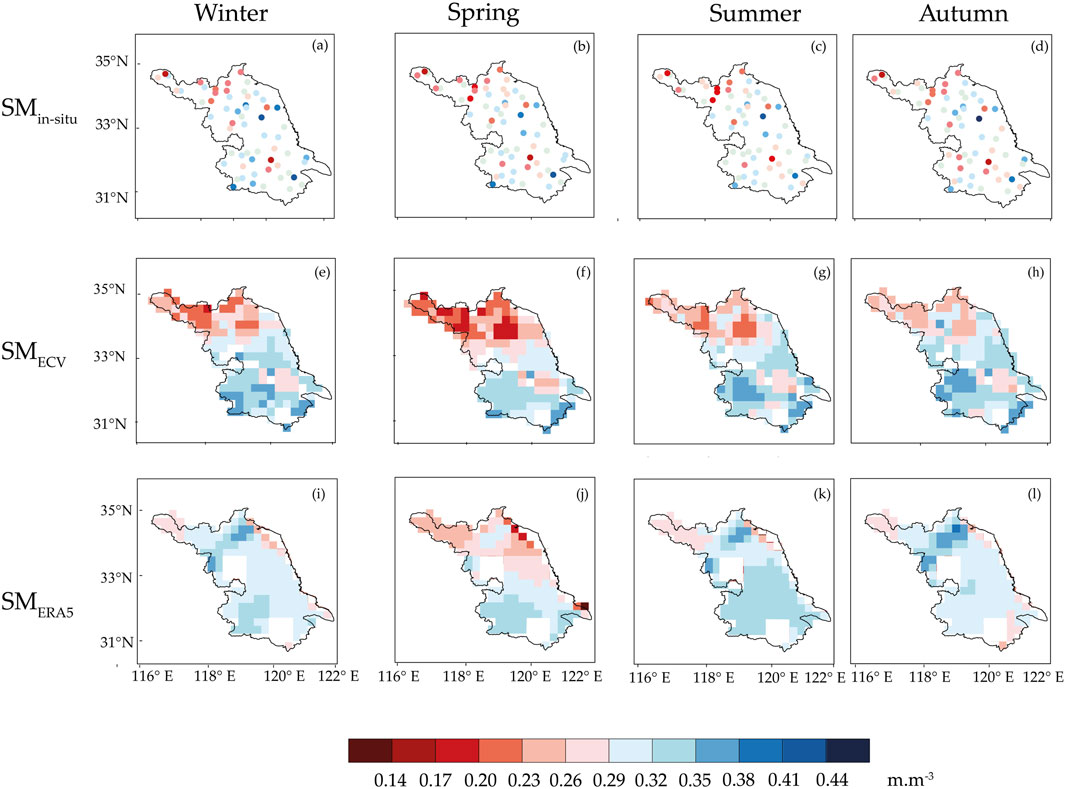
Figure 6. Seasonal mean SMin-situ, SMECV and SMERA5 soil moisture (m3.m-3) in winter, spring, summer and autumn respectively.
During spring season, there is an overall decrease in SMin-situ magnitude in most parts of the region, especially over the northern area. The SMin-situ data soil moisture values are less than 0.29 m3 m-3 in the northern areas, with an increase of absolute magnitude to 0.32 m3 m-3 towards the central area, and to around 0.38 m3 m-3 in the southern area is obvious. The SMECV data in spring season also shows a reduced magnitude and similar spatial distribution as SMin-situ data. Less soil moisture at the northern area with slight increase towards central region and relatively enhanced soil moisture in the southwestern parts. The SMERA5 appears to be consistent with those of the observed and remotely sensed soil moisture products, with less soil moisture, and a distinct increase towards south is evident.
During summer season, SMin-situ data have shown an obvious increase in soil moisture magnitude (< = 0.29 m3 m-3), in north with a slight increase towards central (< = 0.32 m3 m-3) and southern parts. The SMECV data exhibited slight increase and in close agreement with those of in situ observations depicting seasonal transition. A similar increase in the SMERA5 can also be seen, which ranges from 0.29 m3·m-3over the southern to 0.32 m3 m-3 over the northern area and consistently shows relatively higher soil moisture magnitude.
For autumn season, the SMin-situ magnitude decreases over most areas, which is more obvious over the southern (< = 0.23 m3 m-3) and the central area (< = 0.26 m3 m-3); however, there is increase over the northern areas. This seasonal variation is not well captured by the SMECV data, since an overall increase in magnitude are observed. Unlike SMECV data, the SMERA5 show a general decrease from summer to autumn over the whole area except for the northeast part (< = 0.29 m3 m-3), though an overestimation is found.
In conclusion, both SMECV data and SMERA5 data were able to show north-south variation relatively higher soil moisture magnitude over southern areas and lower magnitude over northern areas in all seasons. SMECV closely followed SMin-situ soil moisture in terms of absolute values, whereas SMERA5 consistently overestimated observed and remotely sensed soil moisture. The distinct north-south spatial patterns could be, at least partly, due to the unevenly distributed precipitation over the Jiangsu province, that however may not be represented in SMERA5 data. The regional variation of soil moisture is subjected to precipitation variation and thus both in situ and remotely sensed soil moisture appeared to be capturing such variations much better than reanalysis products. The soil moisture dynamics may be presented and affected by different processes in both observed and reanalysis soil moisture data and thus more detailed investigation is needed in this regard.
3.3 Response to heavy precipitation events
Since soil moisture is part of the terrestrial water cycle, which is highly chaotic and shows major diversity in both space and time (Albergel et al., 2018), its value could easily be altered by a single precipitation event. Hence, the capability of soil moisture response to precipitation event should be a factor in evaluating the soil moisture data, and similar works have been done in many places including Tibetan Plateau and Southwest China (Bi et al., 2016; Peng et al., 2015b). However, their responses of the SMECV and the SMERA5 products to precipitation event over Jiangsu province remain unexplored. Since we want to see the temporal evolution of soil moisture and precipitation during heavy raining events other than annual precipitation, we choose a typical station (shown as in Figure 1) among these 60 stations where has relatively more heavy precipitation events.
The time series of precipitation and soil moisture data, spanning from 2014–01–01 till 2014–12–31, are shown in Figure 7. An obvious response can be seen in the SMin-situ to the precipitation events. The SMERA5 data also shows good responses to heavy precipitation events, indicating its considerable sensitivity to precipitation, although not as good as the SMin-situ data. However, the SMECV response to heavy precipitation events is with inferior performance than the SMERA5 data. Although the SMECV values are also higher when there are precipitation events, their responses are not as distinct as the SMERA5 data. The TRMM (Tropical Rainfall Measuring Mission satellite) precipitation data, which is one of the forcing datasets of the SMERA5 product, has been extensively validated and is a very reliable quantitative precipitation estimates around the world. In addition, Albergel et al. (2018) has demonstrated ERA5 has a good global balance of precipitation and evaporation, which can also be the reason of SMERA5 data better performance. On the other side, it has been proved that SMOS, which is one of the passive sensors used to generate the combined SMECV product in this study (Dorigo et al., 2015), performed not that good in response to precipitation over the southwest China due to the RFI effect (Peng et al., 2015a). Hence, this finding in Peng’s (Peng et al., 2015b) study can also be the explanation in Jiangsu.
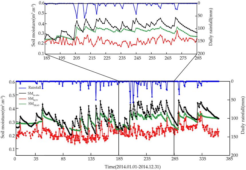
Figure 7. Time variations of soil moisture for SMin-situ, SMECV, SMEAR5 and precipitation from a single station (station number 58047).
4 Discussion
Soil moisture plays a critical role in the land surface-atmosphere coupling process and is key factor in water and energy cycles. Accurate and reliable estimates of soil moisture are essential for numerical weather prediction, hydrological forecasting, and land surface data assimilation. SMERA5 is the successor to the SMERA-Interim reanalysis, while SMECV is a widely used soil moisture product that combines several high-quality satellites products. Both products are considered promising alternatives to in situ soil moisture measurements.
Both SMECV and SMERA5 show similar spatial patterns as SMin-situ across all seasons, generally showing higher moisture in southern areas and lower values in northern areas. However, discrepancies with SMin-situ are observed in areas with higher precipitation and dense vegetation. All three datasets exhibit different seasonal variations in magnitudes. SMERA5 and the SMECV data showed more pronounced seasonal cycles than the relatively stable SMin-situ data.
According to performance metrics, both SMERA5 and the SMECV effectively capture the temporal dynamics of SMin-situ, although subtle differences exist. SMERA5 demonstrates superior performance with higher correlation coefficient and lower TC errors. However, SMECV shows lower random errors (ubRMSD = 0.045 m3 m-3 for SMECV vs 0.052 m3 m-3 for SMERA5), indicating more stable performance related to SMin-situ. Moreover, SMERA5 shows more sensitive response to heavy precipitation events compared to SMECV.
The superior performance of SMERA5 aligns with findings from previous studies, which have demonstrated that SMERA-Interim reanalysis products outperform remotely sensed products in capturing soil moisture variations. This advantage stems from their integration of precipitation observations (Albergel et al., 2012; Peng et al., 2015a). Further supporting this, Yu et al. (2023) evaluated multiple soil moisture products in Central Asia and found that SMERA5 exhibited the closest agreement with SMin-situ observations, achieving an average correlation coefficient of 0.59. In comparison, GLDAS and SMECV followed with coefficients of 0.52, while FLDAS performed less favorably. Regarding error metrics, the patterns diverged: FLDAS showed the highest average ubRMSE (0.054 m3/m3), whereas SMERA5, SMECV, and GLDAS demonstrated comparable performance, with average ubRMSE values ranging between 0.039 m3/m3 and 0.044 m3/m3. In addition, we reveal the variability of three soil moisture products over the study period, highlighting the effects of precipitation on surface soil moisture dynamics. Since SMERA5 shows good response to precipitation, it holds significant potential for improving hydrological forecasting (Hong et al., 2024).
SMERA5 retains the high-quality forcing data used in SMERA-Interim reanalysis, and addresses several known limitations of its predecessor (SMERA-Interim). The assimilation of updated satellite data and improved representation of the global water balance of precipitation and evaporation further support the improved performance of SMERA5. Additionally, it should be noted that the soil depth of each soil moisture data was inconsistent with that of the SMin-situ, which may potentially lead to incomplete control/correction of systematic biases (Li et al., 2022; Yu et al., 2023). In this study, the depth of SMERA5 (0–7 cm) is more comparable to SMin-situ (0–10 cm) than SMECV (0–5 cm), potentially contributing to SMERA5’s better agreement with SMin-situ (Luo et al., 2021).
The results also indicated that the temporal agreement of SMERA5 and SMECV varies across regions. In northern regions, both SMERA5 and SMECV perform relatively poorly in terms of temporal agreement and TC error, confirmed the Taylor Diagrams of three typical areas (Figure 7). By contrast, performance is generally better in the southern area (SE), where both products exhibit higher correlation coefficients with SMin-situ than in northern areas (NW and NE). Notably, regional differences among all indicators are also pronounced over the SE area, which can be explained by the special climate. The prevailing eastly wind from Pacific Ocean induce large fluctuations in temperature, and consequently in soil moisture. Moreover, higher precipitation and solar energy in the SE region due to the Meiyu Belt and humid climate further contribute to the spatial difference. Other influencing factors, including the distance to large water bodies, vegetation cover, and urbanization degree, may also significantly affect accuracy of soil moisture estimates (Hagan et al., 2019; Hagan et al., 2020).
Since soil moisture climatology is the reflection of temporal variations and spatial patterns of long-term meteorological forcing data, whereas soil moisture anomalies are the reflection of short-term forcing dynamics. These findings can provide a valuable reference for improving land surface modes and hydrological forecasting. SMERA5’s sensitivity to precipitation and depth compatibility with in situ data make it a robust candidate for enhancing land surface model initialization and flood forecasting. However, the rapid evolution of soil moisture products necessitates continuous evaluation of emerging datasets. With the recent release of Era-land, a next-generation product integrating advanced satellite observations and machine learning techniques, future research should focus on comparative assessments to determine whether it demonstrates improved performance in regions with complex climate conditions (e.g., high precipitation or dense vegetation) and whether its spatial resolution enhances the monitoring of localized soil moisture dynamics. Such studies would further guide the selection of optimal products for specific hydrological and meteorological applications. However, the rapid evolution of soil moisture products necessitates continuous evaluation of emerging datasets. With the recent release of ERA5-land, a next-generation product integrating advanced satellite observations and machine learning techniques, future research should focus on comparative assessments to determine whether it demonstrates improved performance in regions with complex climate conditions (e.g., high precipitation or dense vegetation) and whether its spatial resolution enhances the monitoring of localized soil moisture dynamics (Muñoz-Sabater et al., 2021; Wu et al., 2021; Zhang et al., 2021). Such studies would further guide the selection of optimal products for specific hydrological and meteorological applications.
5 Conclusion
In this study, we have validated both SMECV and SMERA5 against in situ observations across Jiangsu province, China. The results show that while both SMECV and SMERA5 have their own strengths and weaknesses in capturing soil moisture dynamics compared to SMin-situ.
SMERA5 generally outperforms SMECV in terms of correlation coefficient and response to heavy precipitation, which is in line with previous research and can be attributed to its high - quality data sources and improved assimilation techniques. However, SMECV has lower random errors, indicating more stable performance.
The temporal agreement of the two products with SMin-situ also varies regionally, with better performance in the southern area and relatively poor performance in the northern area. This regional variation is influenced by climate factors such as wind, precipitation, and solar energy, as well as other factors like distance to water bodies, vegetation cover, and urbanization.
Overall, this study provides valuable insights into the performance of SMECV and SMERA5 in different regions and seasons, which can help in the selection and application of these soil moisture products for various purposes such as numerical weather prediction and hydrological forecasting. Future research could further explore the impact of different soil depths and other influencing factors on soil moisture estimates to improve their accuracy and reliability.
Data availability statement
The datasets presented in this article are not readily available because confidentiality of meteorological observation data. Requests to access the datasets should be directed to the corresponding author.
Author contributions
XS: Writing – original draft, Writing – review and editing. RY: Writing – original draft, Validation, Visualization. WU: Conceptualization, Writing – review and editing.
Funding
The author(s) declare that financial support was received for the research and/or publication of this article. This research was funded by Jiangsu Province Marine Science and Technology Innovation Project (JSZRHYKJ202307) and Jiangsu Meteorological Bureau Scientific research project (KM202408).
Conflict of interest
The authors declare that the research was conducted in the absence of any commercial or financial relationships that could be construed as a potential conflict of interest.
Generative AI statement
The author(s) declare that no Generative AI was used in the creation of this manuscript.
Any alternative text (alt text) provided alongside figures in this article has been generated by Frontiers with the support of artificial intelligence and reasonable efforts have been made to ensure accuracy, including review by the authors wherever possible. If you identify any issues, please contact us.
Publisher’s note
All claims expressed in this article are solely those of the authors and do not necessarily represent those of their affiliated organizations, or those of the publisher, the editors and the reviewers. Any product that may be evaluated in this article, or claim that may be made by its manufacturer, is not guaranteed or endorsed by the publisher.
References
Albergel, C., Calvet, J. C., De Rosnay, P., Balsamo, G., Wagner, W., Hasenauer, S., et al. (2010). Cross-evaluation of modelled and remotely sensed surface soil moisture with in situ data in Southwestern France. Hydrology Earth Syst. Sci. 14 (11), 2177–2191. doi:10.5194/hess-14-2177-2010
Albergel, C., De Rosnay, P., Balsamo, G., Isaksen, L., and Muñoz-Sabater, J. (2012). Soil moisture analyses at ECMWF: evaluation using global ground-based in situ observations. J. Hydrometeorol. 13 (5), 1442–1460. doi:10.1175/JHM-D-11-0107.1
Albergel, C., Brocca, L., Wagner, W., de Rosnay, P., and Calvet, J. (2013). “Selection of performance metrics for global soil moisture products,” in Remote sensing of energy fluxes and soil moisture content. Editor G. P. . Petropoulos (Issue OCTOBER: CRC Press), 427–444. doi:10.1201/b15610-22
Albergel, C., Dorigo, W., Reichle, R. H., Balsamo, G., Derosnay, P., Muñoz-sabater, J., et al. (2013). Skill and global trend analysis of soil moisture from reanalyses and microwave remote sensing. J. Hydrometeorol. 14 (4), 1259–1277. doi:10.1175/JHM-D-12-0161.1
Albergel, C., Dutra, E., Munier, S., Calvet, J. C., Munoz-Sabater, J., De Rosnay, P., et al. (2018). ERA-5 and ERA-interim driven ISBA land surface model simulations: which one performs better? Hydrology Earth Syst. Sci. 22 (6), 3515–3532. doi:10.5194/hess-22-3515-2018
An, R., Zhang, L., Wang, Z., Quaye-Ballard, J. A., You, J., Shen, X., et al. (2016). Validation of the ESA CCI soil moisture product in China. Int. J. Appl. Earth Observation Geoinformation 48 (October), 28–36. doi:10.1016/j.jag.2015.09.009
Bartalis, Z., Wagner, W., Naeimi, V., Hasenauer, S., Scipal, K., Bonekamp, H., et al. (2007). Initial soil moisture retrievals from the METOP-A Advanced Scatterometer (ASCAT). Geophys. Res. Lett. 34 (20). doi:10.1029/2007GL031088
Bi, H., Ma, J., Zheng, W., and Zeng, J. (2016). Comparison of soil moisture in GLDAS model simulations and in situ observations over the Tibetan Plateau. J. Geophys. Res. 121 (6), 2658–2678. doi:10.1002/2015JD024131
Chen, T., Zhang, H., Chen, X., Hagan, D. F., Wang, G., Gao, Z., et al. (2017). Robust drying and wetting trends found in regions over China based on Köppen climate classifications. J. Geophys. Res. 122 (8), 4228–4237. doi:10.1002/2016JD026168
Crow, W., and Van Den Berg, M. J. (2010). An improved approach for estimating observation and model error parameters in soil moisture data assimilation. Water Resour. Res. 46 (12), 2010WR009402–12. doi:10.1029/2010WR009402
Dee, D. P., Uppala, S. M., Simmons, A. J., Berrisford, P., Poli, P., Kobayashi, S., et al. (2011). The ERA-Interim reanalysis: configuration and performance of the data assimilation system. Q. J. R. Meteorological Soc. 137 (656), 553–597. doi:10.1002/qj.828
Dharssi, I., Bovis, K. J., Macpherson, B., and Jones, C. P. (2011). Operational assimilation of ASCAT surface soil wetness at the Met Office. Hydrology Earth Syst. Sci. 15 (8), 2729–2746. doi:10.5194/hess-15-2729-2011
Dong, X., Lai, X., Wang, Y., Dong, W., Zhu, J., Dong, L., et al. (2022). Applicability evaluation of multiple sets of soil moisture data on the tibetan plateau. Front. Earth Sci. 10 (August), 872413–872418. doi:10.3389/feart.2022.872413
Dorigo, W., Scipal, K., Parinussa, R. M., Liu, Y. Y., Wagner, W., De Jeu, R. A. M., et al. (2010). Error characterisation of global active and passive microwave soil moisture datasets. Hydrology Earth Syst. Sci. 14 (12), 2605–2616. doi:10.5194/hess-14-2605-2010
Dorigo, W., Wagner, W., Hohensinn, R., Hahn, S., Paulik, C., Xaver, A., et al. (2011). The International Soil Moisture Network: a data hosting facility for global in situ soil moisture measurements. Hydrology Earth Syst. Sci. 15 (5), 1675–1698. doi:10.5194/hess-15-1675-2011
Dorigo, W., Gruber, A., De Jeu, R. A. M., Wagner, W., Stacke, T., Loew, A., et al. (2015). Evaluation of the ESA CCI soil moisture product using ground-based observations. Remote Sens. Environ. 162 (June), 380–395. doi:10.1016/j.rse.2014.07.023
Dorigo, W., Wagner, W., Albergel, C., Albrecht, F., Balsamo, G., Brocca, L., et al. (2017). ESA CCI Soil Moisture for improved Earth system understanding: State-of-the art and future directions. Remote Sens. Environ. 203, 185–215. doi:10.1016/j.rse.2017.07.001
Entekhabi, D., Njoku, E. G., O’Neill, P. E., Kellogg, K. H., Crow, W. T., Edelstein, W. N., et al. (2010). The soil moisture active passive (SMAP) mission. Proc. IEEE 98 (5), 704–716. doi:10.1109/JPROC.2010.2043918
Gruber, A., Scanlon, T., van der Schalie, R., Wagner, W., and Dorigo, W. (2019). Evolution of the ESA CCI Soil Moisture climate data records and their underlying merging methodology. Earth Syst. Sci. Data 11 (2), 717–739. doi:10.5194/essd-11-717-2019
Hagan, D., Wang, G. J., Parinussa, R. M., and Shi, X. (2019). Inter-comparing and improving land surface temperature estimates from passive microwaves over the Jiangsu province of the people’s Republic of China. Int. J. Remote Sens. 40 (14), 5563–5584. doi:10.1080/01431161.2019.1580790
Hagan, D., Parinussa, R. M., Wang, G., and Draper, C. S. (2020). An evaluation of soil moisture anomalies from global model-based datasets over the people’s Republic of China. WaterSwitzerl. 12 (1), 117. doi:10.3390/w12010117
Hagan, D. F. T., Kim, S., Wang, G., Ma, X., Hu, Y., Liu, Y. Y., et al. (2025). Seamless finer-resolution soil moisture from the synergistic merging of the FengYun-3 satellite series. Sci. Data 12 (1), 983–14. doi:10.1038/s41597-025-05263-7
Hersbach, H., Bell, B., Berrisford, P., Hirahara, S., Horányi, A., Nicolas, J., et al. (2020). The ERA5 global reanalysis. Q. J. R. Meteorol. Soc. 146, 1999–2049. doi:10.1002/qj.3803
Holmes, T., De Jeu, R. A. M., Owe, M., and Dolman, A. J. (2009). Land surface temperature from Ka band (37 GHz) passive microwave observations. J. Geophys. Res. Atmos. 114 (4), 2008JD010257–15. doi:10.1029/2008JD010257
Hong, X., Jia, S., Zhu, W., and Song, Z. (2024). Evaluation of global seamless soil moisture products over China: a perspective of soil moisture sensitivity to precipitation. J. Hydrology 641 (July), 131789. doi:10.1016/j.jhydrol.2024.131789
Jia, J., Zhang, P., Yang, X., Zhen, Q., and Zhang, X. (2020). Comparison of the accuracy of two soil moisture sensors and calibration models for different soil types on the Loess Plateau. Soil Use Manag. 2017, 584–594. doi:10.1111/sum.12587
Kistler, R., Kalnay, E., Collins, W., Saha, S., White, G., Woollen, J., et al. (2001). The NCEP-NCAR 50-year reanalysis: monthly means CD-ROM and documentation. Bull. Am. Meteorological Soc. 82 (2), 247–267. doi:10.1175/1520-0477(2001)082<0247:TNNYRM>2.3
Kokkalis, P., Al Jassar, H. K., Al Sarraf, H., Nair, R., and Al Hendi, H. (2024). Evaluation of ERA5 and NCEP reanalysis climate models for precipitation and soil moisture over a semi-arid area in Kuwait. Clim. Dyn. 62 (6), 4893–4904. doi:10.1007/s00382-024-07141-1
Lal, P., Singh, G., Das, N. N., Colliander, A., and Entekhabi, D. (2022). Assessment of ERA5-Land volumetric soil water layer product using in situ and SMAP soil moisture observations. IEEE Geoscience Remote Sens. Lett. 19, 1–5. doi:10.1109/LGRS.2022.3223985
Lei, F., Crow, W., Shen, H., Parinussa, R. M., and Holmes, T. R. H. (2015). The impact of local acquisition time on the accuracy of microwave surface soil moisture retrievals over the contiguous United States. Remote Sens. 7 (10), 13448–13465. doi:10.3390/rs71013448
Li, M., Wu, P., and Ma, Z. (2020). A comprehensive evaluation of soil moisture and soil temperature from third-generation atmospheric and land reanalysis data sets. Int. J. Climatol. 40 (13), 5744–5766. doi:10.1002/joc.6549
Li, Q., Shi, G., Shangguan, W., Nourani, V., Li, J., Li, L., et al. (2022). A 1 km daily soil moisture dataset over China using in situ measurement and machine learning. Earth Syst. Sci. Data 14 (12), 5267–5286. doi:10.5194/essd-14-5267-2022
Lou, D., Wang, G., Shan, C., Hagan, D. F. T., Ullah, W., and Shi, D. (2018). Changes of soil moisture from multiple sources during 1988-2010 in the yellow River Basin, China. Adv. Meteorology 2018, 1–14. doi:10.1155/2018/1950529
Luo, M., Sa, C., Meng, F., Duan, Y., Liu, T., and Bao, Y. (2021). Assessing remotely sensed and reanalysis products in characterizing surface soil moisture in the Mongolian Plateau. Int. J. Digit. Earth 14, 1255–1272. doi:10.1080/17538947.2020.1820590
Ma, H., Zeng, J., Chen, N., Zhang, X., Cosh, M. H., and Wang, W. (2019). Satellite surface soil moisture from SMAP, SMOS, AMSR2 and ESA CCI: a comprehensive assessment using global ground-based observations. Remote Sens. Environ., 231, 111215. doi:10.1016/j.rse.2019.111215
McColl, K. A., Vogelzang, J., Konings, A. G., Entekhabi, D., Piles, M., and Stoffelen, A. (2014). Extended triple collocation: estimating errors and correlation coefficients with respect to an unknown target. Geophys. Res. Lett. 41 (17), 6229–6236. doi:10.1002/2014GL061322
Miralles, D. G., Teuling, A. J., Van Heerwaarden, C. C., and De Arellano, J. V. G. (2014). Mega-heatwave temperatures due to combined soil desiccation and atmospheric heat accumulation. Nat. Geosci. 7 (5), 345–349. doi:10.1038/ngeo2141
Muñoz-Sabater, J., Dutra, E., Agustí-Panareda, A., Albergel, C., Arduini, G., Balsamo, G., et al. (2021). ERA5-Land: a state-of-the-art global reanalysis dataset for land applications. Earth Syst. Sci. Data 13 (9), 4349–4383. doi:10.5194/essd-13-4349-2021
Parinussa, R., Holmes, T. R. H., and De Jeu, R. A. M. (2012). Soil moisture retrievals from the windSat spaceborne polarimetric microwave radiometer. IEEE Trans. Geoscience Remote Sens. 50 (7 PART 2), 2683–2694. doi:10.1109/TGRS.2011.2174643
Parinussa, R., Wang, G., Liu, Y., Lou, D., Tawia, D. F., Zhan, M., et al. (2018). Improved surface soil moisture anomalies from Fengyun-3B over the Jiangxi province of the People ’ s Republic of China improved surface soil moisture anomalies from Fengyun-3B. Int. J. Remote Sens. 00 (00), 1–13. doi:10.1080/01431161.2018.1500729
Peng, J., Niesel, J., and Loew, A. (2015a). Evaluation of soil moisture downscaling using a simple thermal-based proxy-the REMEDHUS network (Spain) example. Hydrology Earth Syst. Sci. 19 (12), 4765–4782. doi:10.5194/hess-19-4765-2015
Peng, J., Niesel, J., Loew, A., Zhang, S., and Wang, J. (2015b). Evaluation of satellite and reanalysis soil moisture products over southwest China using ground-based measurements. Remote Sens. 7 (11), 15729–15747. doi:10.3390/rs71115729
Rienecker, M. M., Suarez, M. J., Gelaro, R., Todling, R., Bacmeister, J., Liu, E., et al. (2011). MERRA: nasa’s modern-era retrospective analysis for research and applications. J. Clim. 24 (14), 3624–3648. doi:10.1175/JCLI-D-11-00015.1
Scipal, K., Holmes, T., De Jeu, R., Naeimi, V., and Wagner, W. (2008). A possible solution for the problem of estimating the error structure of global soil moisture data sets. Geophys. Res. Lett. 35 (24), 2008GL035599–5. doi:10.1029/2008GL035599
Scipal, K., Dorigo, W., and De Jeu, R. (2010). Triple collocation - a new tool to determine the error structure of global soil moisture products. Int. Geoscience Remote Sens. Symposium (IGARSS) 3 (2), 4426–4429. doi:10.1109/IGARSS.2010.5652128
Shellito, P. J., Small, E. E., Colliander, A., Bindlish, R., Cosh, M. H., Berg, A. A., et al. (2016). in Situfollowing rainfall events, 1–8. doi:10.1002/2016GL069946
Ullah, W., Wang, G., Gao, Z., Hagan, D. F. T., and Lou, D. (2018). Comparisons of remote sensing and reanalysis soil moisture products over the Tibetan Plateau, China. Cold Regions Sci. Technol. 146 (December 2017), 110–121. doi:10.1016/j.coldregions.2017.12.003
Wu, Q., Liu, H., Wang, L., and Deng, C. (2016). Evaluation of AMSR2 soil moisture products over the contiguous United States using in situ data from the International Soil Moisture Network. Int. J. Appl. Earth Observation Geoinformation 45, 187–199. doi:10.1016/j.jag.2015.10.011
Wu, Z., Feng, H., He, H., Zhou, J., and Zhang, Y. (2021). Evaluation of soil moisture climatology and anomaly components derived from ERA5-Land and GLDAS-2.1 in China. Water Resour. Manag. 35 (2), 629–643. doi:10.1007/s11269-020-02743-w
Xu, L., Chen, N., Zhang, X., Moradkhani, H., Zhang, C., and Hu, C. (2021). In-situ and triple-collocation based evaluations of eight global root zone soil moisture products. Remote Sens. Environ. 254 (December 2020), 112248. doi:10.1016/j.rse.2020.112248
Yang, S., Zeng, J., Fan, W., and Cui, Y. (2022). Evaluating root-zone soil moisture products from GLEAM, GLDAS, and ERA5 based on in situ observations and triple collocation method over the Tibetan Plateau. J. Hydrometeorol. 23 (12), 1861–1878. doi:10.1175/JHM-D-22-0016.1
Yin, J., Yan, D., Yang, Z., Yuan, Z., Yuan, Y., Wang, H., et al. (2016). Research on historical and future spatial-temporal variability of precipitation in China. Adv. Meteorology 2016, 1–14. doi:10.1155/2016/9137201
Yu, T., Bao, A., Zhang, J., Tu, H., Chen, B., De Maeyer, P., et al. (2023). Evaluating surface soil moisture characteristics and the performance of remote sensing and analytical products in Central Asia. J. Hydrology 617 (PA). doi:10.1016/j.jhydrol.2022.128921
Yuan, Q., Wang, G., Zhu, C., Lou, D., Hagan, D. F. T., Ma, X., et al. (2020). Coupling of soil moisture and air temperature from multiyear data during 1980-2013 over China. Atmosphere 11 (1), 25. doi:10.3390/ATMOS11010025
Zeng, J., Li, Z., Chen, Q., Bi, H., Qiu, J., and Zou, P. (2015). Evaluation of remotely sensed and reanalysis soil moisture products over the Tibetan Plateau using in-situ observations. Remote Sens. Environ. 163, 91–110. doi:10.1016/j.rse.2015.03.008
Zhang, R., Li, L., Zhang, Y., Huang, F., Li, J., Liu, W., et al. (2021). Assessment of agricultural drought using soil water deficit index based on era5-land soil moisture data in four southern provinces of China. Agric. Switz. 11 (5), 411. doi:10.3390/agriculture11050411
Zhu, L., Wang, H., Tong, C., Liu, W., and Du, B. (2019). Evaluation of ESA active, passive and combined soil moisture products using upscaled ground measurements. Sensors Switz. 19 (12), 2718. doi:10.3390/s19122718
Keywords: spatial pattern, temporal dynamics, correlation coefficients, triple collocation, differences, uncertainties
Citation: Shi X, Yang R and Ullah W (2025) Evaluation of ERA5 reanalysis and ECV satellite soil moisture products based on in situ observations over Jiangsu, China. Front. Environ. Sci. 13:1672787. doi: 10.3389/fenvs.2025.1672787
Received: 28 July 2025; Accepted: 12 September 2025;
Published: 30 September 2025.
Edited by:
Zheng Duan, Lund University, SwedenCopyright © 2025 Shi, Yang and Ullah. This is an open-access article distributed under the terms of the Creative Commons Attribution License (CC BY). The use, distribution or reproduction in other forums is permitted, provided the original author(s) and the copyright owner(s) are credited and that the original publication in this journal is cited, in accordance with accepted academic practice. No use, distribution or reproduction is permitted which does not comply with these terms.
*Correspondence: Ruyi Yang, eWFuZ3J5QGNtYS5nb3YuY24=