 Hao Chen
 Yingwei Wang
 Zhongqi Cheng
 Li Ma
Li Ma- Engineering Research Center of Rural Environmental Protection and Green Low-Carbon Development of Sichuan Province, Mianyang Normal University, Mianyang, China
The construction of regional ecological security networks serves as an important strategy for improving the function of ecosystem services, identifying ecological restoration priority areas based on overall protection and systematic management is the main measure to promote the ecological restoration of national land space in a scientific and orderly manner. In this study, the Fujiang River Basin was taken as the study area, while the human footprint and landscape ecological risk model were used to quantitatively evaluate the negative interference of the ecosystem. The importance evaluation results of ecosystem services and the minimum cumulative resistance model were used to construct the ecological security network of the Fujiang River Basin with the ecological source as the “key patch,” the ecological corridor as the “axis”, and the ecological node as the “hub.” The key areas with high negative interference in the ecological network were extracted as the priority areas of ecological restoration and targeted restoration measures were proposed. The results showed that: (1) the importance of ecosystem services in the Fujiang River Basin could be comprehensively analyzed by selecting indicators such as water conservation, soil and water conservation, and habitat quality. The Conefor tool was used to evaluate the landscape connectivity of candidate source patches, where 23 ecological sources were extracted, an ecological source area of 7638.88 km2 was identified, which was clustered in the eastern margin of the Qinghai-Tibet Plateau and sporadically distributed in the parallel mountains of eastern Sichuan. (2) The ecological corridors in the study area were distributed in the “cobweb” pattern, with a total length of 2249.32 km, and 26 ecological nodes were scattered in the low-resistance area of the corridors. Based on the ecological network of sources and corridors forming networks, habitat connectivity, the ecological construction idea of one corridor and two areas was proposed. (3) Based on the spatial superposition of ecological security networks and negative interference surfaces, the priority areas of ecological restoration in the Fujiang River Basin were identified. Combined with the spatial distribution characteristics and typical problems of each priority area for ecological restoration, corresponding ecological restoration strategies were proposed to ensure connectivity between ecological sources and the integrity and stability of ecological networks. The above results could serve as a scientific reference for clarifying the ecological security pattern of the study area, improving the dynamic monitoring ability of ecologically fragile areas, and formulating targeted protection and restoration measures.
1 Introduction
High-intensity land use and the exploitation of natural resources directly affect regional ecological processes and landscape spatial patterns, resulting in gradual degradation of the fragile ecological environment. As a result, maintaining the connectivity and integrity of the ecological process has gradually attracted the increasing attention of the academic community (Lausch et al., 2015; He et al., 2017; Du et al., 2023; Masoudi et al., 2024; Song et al., 2025). The concept of ecological security emphasizes the sustainable development of resources, environment, and ecosystem.Constructing regional ecological security networks serves as a key strategy for maintaining biodiversity, protecting natural resources, and improving environmental quality (Kedron et al., 2018; Wang and Pan, 2019; Li et al., 2022; Zhou et al., 2025). In the 1990s, the concept of landscape ecological security patterns was proposed, analyzing individual ecological processes such as water conservation, soil retention, and biodiversity conservation. These patterns were evaluated using indicators like vegetation coverage, soil erosion risk, and species distribution data (Peng et al., 2017). Early research primarily focused on the construction of ecological protection networks in nature reserves and forest parks (Peng et al., 2017). However, with the advancement of source-sink theory, ecological balance theory, and 3S technologies, the development of ecological security networks has evolved from initial qualitative planning and theoretical concept analysis to quantitative research.
A core goal of ecological security pattern construction has emerged: identifying the spatial location of key ecological elements, linking isolated landscape elements, and improving the overall function of regional ecosystems at the lowest cost (Liu et al., 2024). Based on these concepts, the mainstream research framework of identifying the ecological source-construction of ecological resistance surface-simulation of ecological corridors-extraction of ecological nodes has been gradually formed (Ma et al., 2021; Lin et al., 2022; Yao et al., 2023; Feng et al., 2024). Ecological sources are critical ecological patches that support regional ecological security by maintaining the integrity of ecological processes and functions. Depending on the research objectives, ecological sources can be extracted using methods such as nature reserve identification (Yan et al., 2025), morphological spatial pattern analysis (MSPA) (Zhou et al., 2022; Hu et al., 2023; Feng et al., 2024; Li X. et al., 2025), and ecosystem service value assessments (Hao et al., 2017; Li K. X. et al., 2024; Wei et al., 2025; Zhou et al., 2025). Ecological resistance surfaces represent the difficulty species face when migrating and spreading between ecological sources. These are typically based on the resistance values given by different land use types. Combined with regional characteristics, the basic resistance surface can be modified using relevant methods such as the topographic index and night light (Wang B. et al., 2024). Ecological corridors serve as connected carriers of material flow and energy flow between ecological source patches. Based on the construction of ecological resistance surfaces, the minimum cumulative resistance model (MCR) (Yao et al., 2023; Qin et al., 2024; Chen et al., 2025) and circuit theory (Shifaw et al., 2024; Wang X. et al., 2024; Zhang R. et al., 2025; Zhang T. et al., 2025) have been used to extract ecological corridors. Among these, the MCR model can better simulate the potential trend of biological spatial movement by calculating the minimum cumulative resistance and the shortest cost path of species migration and dispersal among different ecological source sites. Ecological nodes serve as the stopover points of migratory species along the ecological corridor, which can often be obtained by establishing a topological relationship to extract the intersection of the surface valley line of cumulative resistance and ecological corridor (Zhou et al., 2021; Lin et al., 2022; Yao et al., 2023).
Priority areas for ecological restoration serve as key areas where ecological functions may be seriously damaged and must be restored and reconstructed. The accurate identification of priority areas for ecological restoration based on the construction of ecological security networks and improvement of ecosystem stability is considered the key to the ecological restoration of national land (Xiang et al., 2023). Most existing ecological restoration studies have focused on the restoration of single elements such as contaminated sites and abandoned mines (Peng et al., 2018), or directly defining ecological sources (Ma et al., 2021), ecological pinches (Li M. R. et al., 2024), and ecological barriers (Tu et al., 2022) as priority or core areas for restoration. Furthermore, research has mostly focused on cities or urban agglomerations in the eastern plains (Ma et al., 2021; Lin et al., 2022; Shifaw et al., 2024; Niu et al., 2025; Li X. et al., 2025). As a result, the priority areas for the ecological modification of watershed systems based on ecological risk and human disturbance has not been sufficiently explored.
The scientific identification of key areas for ecological restoration depends on the rationality of ecological network construction, and the key to whether the ecological network is reasonable lies in the identification of ecological sources and the extraction of ecological corridors. As mentioned above, in previous studies, nature reserves or forest areas with high vegetation coverage were often directly selected as ecological sources. The establishment of nature reserves itself has strong administrative control factors, and its internal spatial differences have gradually increased along with time, local areas are prone to landscape fragmentation and decline in ecosystem services; the selection of forest land patches as ecological sources ignores the internal differences of the same land type. This study evaluated the importance of ecosystem services from three aspects: water conservation, soil and water conservation, and habitat quality, and extracted ecological sources. It fully considered the ecosystem service level of ecological sources, reflected the degree of ecosystem response to natural environmental changes and human disturbance, and avoided the shortage of directly using patches such as nature reserves and woodlands as ecological sources. The MCR model simulates the best path of biological migration by constructing the resistance surface, thus the setting of the resistance surface becomes the key to the accurate identification of the corridor. This study constructed the basic resistance surface based on natural factor indicators, and corrected the basic resistance surface by using population density, night lighting, road traffic and landscape ecological risk conditions, which fully considered the influence of natural factors and human activities on the construction of ecological resistance surface, and also reflected the adaptive ability of the ecosystem to various disturbances. The existing research on the identification method of key areas of ecological restoration was relatively insufficient, as mentioned above, ecological sources and ecological obstacle points were often directly defined as priority areas for restoration, resulting in unclear correlation between key areas of ecological restoration and ecological network construction. In this study, the ecological sources, ecological corridors, and ecological nodes in the ecological network subjected to more than moderate negative interference were defined as the priority areas for ecological restoration in the Fujiang River Basin, and corresponding restoration strategies were proposed, these were used to provide scientific references for ensuring the normal performance of ecosystem service functions in the basin, and serve as a reference for constructing the ecological security network and identifying key areas for ecological restoration in other regions.
2 Overview of the study area
The Fujiang River, originating from the main peak (Xuebaoding) of the Minshan Mountains, serves as the largest tributary on the right bank of the Jialing River. The mainstream has a total length of 668 km, with a basin area of 39,500 km2. This basin is located in the transition zone between the eastern margin of the Qinghai-Tibet Plateau and the Sichuan Basin, with the terrain tilted from northwest to southeast. The upstream basin is dominated by medium and small undulating mid-altitude mountain landforms, with the midstream and downstream basins dominated by low-altitude plains and hilly landforms. From the perspective of spatial differentiation of landscape pattern, the study area is located in the plateau/plain ecological transition zone, with a relatively high forest and grass coverage rate in the upper reaches of the basin, and land use types consisting of cultivated and construction land, which have undergone relatively strong artificial transformation, mainly concentrated in the middle and lower reaches (Figure 1). In recent years, due to the influence of mountain disasters such as collapse, landslide, and debris flow and the interference of human activities, single and homogeneous landscape patches in certain key ecological areas have become fragmented (Zhang et al., 2021). In addition, the response of ecosystems in the ecological transition zone to environmental fluctuations has remained more sensitive than in adjacent areas, making the ecological risk problems faced by the study area increasingly more serious.
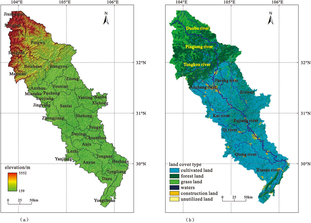
Figure 1. Digital elevation and land cover types in the Fujiang River Basin. (a) Digital elevation of Fujiang river basin. (b) Land cover type of Fujiang river basin.
3 Data sources
The basic data used in this study included surface cover type, normalized difference vegetation index, digital elevation model, slope, the distribution of roads and water areas, soil erosion modulus, soil seepage flow, land use type, population density, night light, net primary productivity of vegetation, and multi-year average annual precipitation. The following data types, sources, and other information were used (Table 1).
Table 1. Data information list.
4 Research methods
4.1 Identification of ecological sources
Ecological sources serve as key areas that provide ecological supply services and ensure the structural integrity of the ecosystem (Liu et al., 2019; Deng et al., 2024; Li Z. et al., 2024; Zhou et al., 2025). Therefore, ecosystem services have become the main indicator for identifying ecological sources. This study followed the method of delineating the importance of ecosystem services according to the “Technical Guidelines for Delineating Ecological Conservation Red Lines” issued by the Ministry of Environmental Protection. Specifically, three indicators were selected, namely, water conservation, soil and water conservation, and habitat quality, to comprehensively analyze the ecological quality of the Fujiang River Basin. The importance of ecosystem services was divided into five levels (low level, lower level, medium level, higher level, and high level) using the natural breakpoint method. Areas with relatively high importance of ecological services where grid cells were concentrated and contiguous data were selected as candidate ecological sources. The following calculation formulas were used for each index (Yao et al., 2023):
The importance of water conservation can be calculated by:
where WR is the importance index of water conservation, NPPmean is the average value of the net primary productivity of vegetation for many years, Fsic is the soil percolation factor, Fpre is the multi-year average precipitation factor, and Fslo is the slope factor.
The importance of soil and water conservation can be calculated by:
where Spro is the importance index of soil and water conservation, NPPmean is the average value of the net primary productivity of vegetation for many years, K is the soil erodibility factor, and Fslo is the slope factor.
Habitat quality represents the ability of the ecological environment to maintain the survival and reproduction of organisms. To a certain extent, habitat quality reflects the level of biodiversity, and its influencing factors are mainly land use types and habitat threat factors (Liu X. et al., 2023; Du et al., 2024; Niu et al., 2025). In this study, the habitat quality module of the InVEST model was used to evaluate the habitat quality in the study area. The following calculation method was used (Niu et al., 2025):
where Axj is the habitat quality of patch x for land use type j, Hj is the habitat suitability of land use in type j, Dxj is the threatened degree of patch x in land use type j, K is the semi-saturation coefficient, and Z is a constant.
The above indicators consisted of a grid superimposed using ArcGIS 10.8, and the importance degree of ecosystem services was divided into five grades through the natural breakpoint method, and areas with higher importance of ecological services were selected as candidate ecological sources.
Through calculation, when the threshold value of the patch area of the candidate ecological sources was 10 km2, the proportion of the number of patches and the patch area began to stabilize, indicating that although the number of patches of the candidate ecological sources below 10 km2 was large, the area of a single patch was small and the distribution was more dispersed, which had little effect on maintaining the overall ecological pattern of the study area. Therefore, in order to reduce the fragmentation degree of ecological sources, patches with an area of less than 10 km2 were eliminated. Based on this, the landscape connectivity (IIC) of candidate source patches was evaluated using the Conefor tool, and patches with good connectivity were identified as ecological source patches.
The following calculation formula for landscape connectivity indicator was used (Wang B. et al., 2024; Chen B. et al., 2025).
where n is the number of patches; ai and aj are the area of patches i and j, respectively; lij is the topological distance of patches i and j; and AL is the total area of the patches. A larger IIC value means a higher degree of connection, indicating that the patch was more important in landscape connectivity.
4.2 Construction of ecological resistance surface
4.2.1 Construction of basic resistance surface
Ecological resistance serves as an ecological obstacle that must be overcome for species migration, energy flow and information transfer between sources, with natural factors serving as the basic source of resistance to the diffusion of material and energy between sources (Tu et al., 2022; Yan et al., 2025). According to the ecological status of the Fujiang River Basin, six natural factor indicators, namely, the elevation, slope, surface cover type, normalized difference vegetation index, the distance from water areas, and soil erosion intensity, were selected and reclassified into five grades. The spatial principal component analysis was used to determine the weight value of each evaluation factor, and the ecological resistance values of each factor were weighted and superimposed. On this basis, the basic resistance surface of the Fujiang River Basin was constructed.
The formula could be expressed as follows (Fan et al., 2022):
where E is the comprehensive evaluation result of basic resistance, an is the weight of each evaluation factor, and xn denotes the ecological resistance grade value of each evaluation factor.
4.2.2 Resistance surface correction
Natural factors serve as fundamental factors influencing species migration, energy flow, and information transmission. High-intensity human activity has been shown to significantly change natural habitats, resulting in the degradation of regional ecosystem service functions, blocking original corridors, and reducing the connectivity of ecological networks. In areas with high values of landscape ecological risks, habitat patches may be fragmented, with species migration, energy flow, and anti-interference ability remaining relatively weak. This makes it necessary to correct basic resistance surfaces through human interference and ecological risk.
4.2.2.1 Human interference assessment based on human footprint
Human footprint (HF) serves as a common indicator for evaluating the impact of human disturbances on terrestrial ecosystems from the perspective of ecological effects. According to existing human footprint system architecture and the regional characteristics of the study area, four typical human activity indicators, including population density, land use, and nighttime lighting and traffic impact, were selected to draw human footprints and quantify the degree of human disturbance to ecosystems. The following calculation formulas were used (Xiang et al., 2023):
where pop is the population density index, landuse is the land use impact index, nightlight is the night light index, and access is the traffic impact index, HF is the human footprint, HII is the human influence index, and HIImax and HIImin denote the maximum and minimum values of the human influence index in the study area, respectively.
4.2.2.2 Landscape ecological risk assessment
Landscape ecological risk refers to the negative impact of various disturbances on the interaction between ecological environment and landscape pattern, reflecting the self-adaptive ability of ecosystem (Ju et al., 2021; Guo et al., 2023; Yang et al., 2024). Three indicators, namely, landscape fragmentation, landscape separation, and landscape dominance, were selected to construct the landscape disturbance index. Subsequently, the landscape ecological risk level of the study area was comprehensively quantified by the landscape disturbance degree and landscape fragility degree. The calculation formula of each index was as follows:
Landscape fragmentation can be used to characterize the process by which the landscape changes from a single, homogeneous, and continuous whole to complex, heterogeneous, and discontinuous patches under the influence of natural disturbance and human activities (Wang et al., 2023; Gou et al., 2024; Zhang B. et al., 2024). The landscape fragmentation can reflect the complexity of the landscape spatial structure, where the larger the value, the lower the internal stability of the landscape unit. The expression of landscape fragmentation is given by (Zhang S. et al., 2024):
where Ci is the landscape fragmentation index, Bi is the number of patches in the landscape of category i, and Ai is the total area of the landscape of category i.
Landscape separation can be used to measure the degree of dispersion of different patches of a certain landscape in a spatial distribution (Ran et al., 2022; Li K. X. et al., 2024), where the larger the value, the more dispersed the landscape distribution of this type, and the lower the ecological stability. The expression of landscape separation is given by (Ran et al., 2022):
where Si is the landscape separation index, and A is the total area of the study area.
Landscape dominance can be used to characterize the dominance of a certain landscape type in spatial patterns, with its calculation typically combined with indicators such as the number, area, and spatial distribution characteristics of landscape patches (Gou et al., 2024). Notably, the larger the value, the stronger the effect on maintaining the stability of the pattern. The expression of landscape dominance is given by (Gou et al., 2024):
where Ei is the landscape dominance index, and Qi is the patch density, indicating the ratio of the number of landscape patches to the total number of patches, Pi is the patch frequency, indicating the ratio of the number of landscape sample areas to the total number of sample areas, and Li is the ratio of the area of a certain type of landscape to the total area of the study area.
Landscape disturbance degree can be used to measure the ability of a landscape to resist external interference and self-repairing ability (Wang et al., 2021; Zhang B. et al., 2024), where the greater the interference intensity of landscape pattern by natural factors and human factors, the higher the landscape ecological risk. The expression of landscape disturbance degree is given by Zhang S. et al. (2024):
where Fi represents the landscape disturbance index, and a, b, and c signify the weight values of the three landscape indices, namely, landscape fragmentation, landscape separation, and landscape dominance.
Landscape vulnerability represents the sensitivity of different types of landscapes to external disturbances, serving as a quantitative scale for various types of landscapes to maintain stability under external disturbances (Lin and Wang, 2023; Gou et al., 2024). According to the actual characteristics of the study area, six types of landscapes were assigned, with unused land assigned to 6, water area assigned to 5, cultivated land assigned to 4, grassland assigned to 3, forest land assigned to 2, and construction land assigned to 1. After normalization processing. The vulnerability degrees of the six types of landscapes were 0.286, 0.238, 0.190, 0.143, 0.095, and 0.048, respectively.
The landscape ecological risk index serves as a quantitative expression of the overall risk of the ecosystem. This index serves as the sum of ecological risks for each landscape type in each risk area, with its value reflecting the level of risk faced by the ecosystem (Ran et al., 2022; Wang et al., 2023; Guo et al., 2025). The following calculation formula for landscape ecological risk index was used (Guo et al., 2025):
where n represents the number of all landscape types, Aki is the area of the ith landscape type in the kth risk unit, and Ak is the total area of the kth risk unit. The calculation results of ERI were divided into five grades.
The spatial distribution of landscape ecological risk and the human footprint in the Fujiang River Basin were weighted and superimposed to obtain the negative interference surface of the ecological network, where the basic resistance surface was corrected and analyzed using the negative interference surface.
4.3 Identification of ecological corridors and ecological nodes
Ecological corridors consist of linear channels that enable the transfer and flow of ecological elements between ecological sources. Based on the value of the ecological source and comprehensive resistance surface, the cost path tool was used, where the minimum cost path from each ecological source to other ecological sources was simulated in sequence. Combined with merging and redundancy removal, complete ecological corridors in the study area were constructed.
Based on the analysis of ecological sources, distances, and landscape interface characteristics, the minimum cumulative resistance model (MCR) was used to simulate the obstructive effect of landscape elements on species migration between ecological source sites (Yan et al., 2021; Liu H. et al., 2023; Liu et al., 2025). The minimum cumulative resistance path serves as a highly likely effective ecological corridor path, acting as a potential ecological corridor (Wu et al., 2024; Chen W. et al., 2025), with the following calculation method (Zhang B et al., 2024; Yan et al., 2025):
where MCR is the minimum cumulative resistance value, fmin is the positive correlation function between the minimum cumulative resistance and ecological process, Dij is the spatial distance from ecological source j to grid i, Ri denotes the resistance value of grid i to the ecological flow, and j = n and i = m represent the sum of the grid unit distances and total cumulative resistance of the species migration between the sources, respectively.
The valley line of the cumulative resistance surface in the Fujiang River Basin was extracted by using the river network classification plugin in ArcGIS, where the intersection point of the ecological corridor and the valley line was defined as the ecological node (Yao et al., 2023; Li M. R. et al., 2024). As low-value areas of ecological resistance along the route of energy flow, information transmission, and species migration, ecological nodes are considered stepping stones and temporary rest points in corridors, providing temporary habitats for the migration and flow of ecological elements between sources and promoting the diffusion of ecological elements in a broader geographical space.
4.4 Diagnosis of priority areas for ecological restoration
A complete and unobstructed ecological network is crucial for maintaining regional ecological security and enhancing the diversity, stability, and sustainability of ecosystems. The integrity and stability of ecological networks are considered closely related to the condition of the ecosystem itself and the interference of human activities. In this study, the negative interference surface weighted by landscape ecological risk and human footprint was spatially superimposed with the ecological network, and areas with higher negative interference in the ecological network were identified as priority areas for ecological restoration in the Fujiang River Basin. Corresponding ecological restoration strategies were proposed according to the typical problems and spatial distribution characteristics of different priority areas for ecological restoration.
5 Results analysis
5.1 Spatial distribution of ecological sources
Based on the calculation of the importance of ecosystem services and landscape connectivity, 23 ecological sources were extracted, 7638.88 km2 of ecological sources were identified in the study area, accounting for 19.33% of the total area of the Fujiang River Basin (Figure 2). Considering the spatial distribution characteristics, there was large overlap between the ecological source and the important forest resources in the Fujiang River Basin. The ecological sources were clustered in the upper reaches of the basin, with an area of 7387.15 km2, accounting for 96.70% of the total area of the ecological sources in the study area. The main reason was that the upper reaches of the Fujiang River were located in the control area of the Minshan uplift zone and Longmenshan fault zone. The landform type was dominated by high mountains and deep valleys, with high forest coverage, which provided a spatially continuous and stable habitat for organisms and became the source of species diffusion, energy flow, and information transmission in the entire basin. In the southern part of the Fujiang River Basin, the ecological source area (239.18 km2) was scattered and fragmented in the Yunwu Mountain, Bayue Mountain, Ji Mountain, Ying Mountain, and other branches of the Huaying Mountains (Tongliang, Dazu, Yongchuan and other counties in Chongqing city). These served as the key ecological patches for regulating the water cycle, maintaining the integrity of the ecosystem and providing biological habitats.
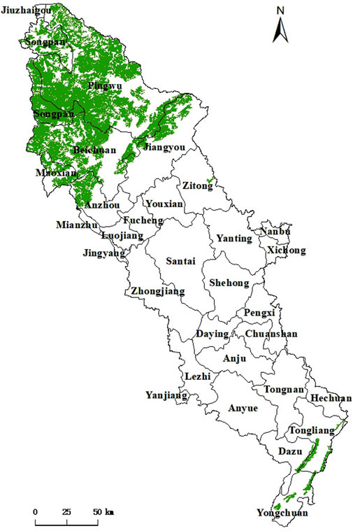
Figure 2. Ecological source of the Fujiang River Basin.
5.2 Ecological resistance surface grade
Natural factors such as the elevation, slope, land cover type, vegetation coverage, distance from water areas, and soil erosion intensity serve as the basic sources of resistance to species migration, energy flow, and information transfer between ecological sources. In this study, the above six natural factors were selected to construct the basic resistance surface of the Fujiang River Basin, and the weight of each evaluation factor was calculated via spatial principal component analysis (Table 2). As shown in Figure 3, the distribution trend of ecological resistance of surface cover type and normalized vegetation index was similar, the upstream basin mainly involved the low ecological resistance area, and the resistance value of the middle and lower reaches was relatively high. By contrast, the upstream basin located in the alpine canyon area had a higher altitude and steeper slope, with the potential risk of geological disasters such as collapse, landslide, and debris flow, along with a high ecological resistance level. The high-altitude area of the upstream basin had a large topographic fluctuation and steep slope. Surface runoff could easily to form with a fast flow rate, and relatively strong soil erosion, while the ecological resistance caused by soil erosion in the upstream basin was higher than in the downstream. The distribution and connectivity of water areas played an important role in improving the ecological environment, maintaining biodiversity, and ensuring the sustainable use of water resources. Therefore, the closer the distance to the water system, the lower the ecological resistance value.
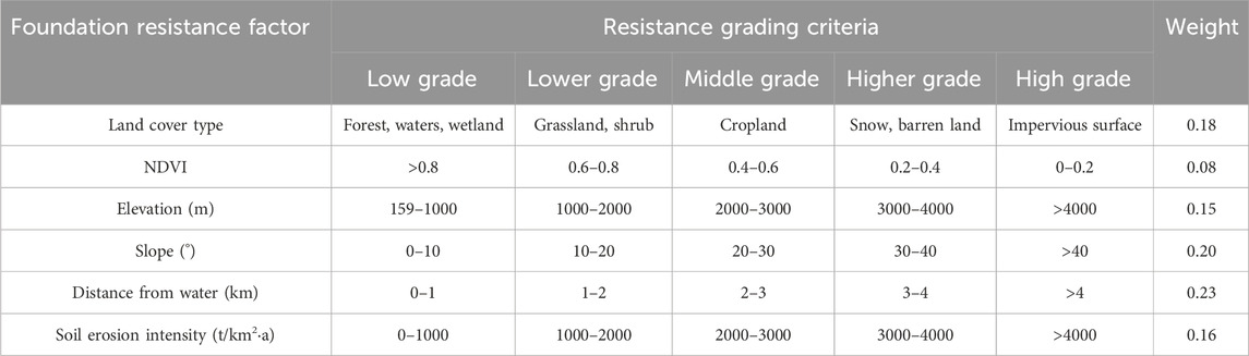
Table 2. The grading criteria of foundation resistance factors in Fujiang River Basin.
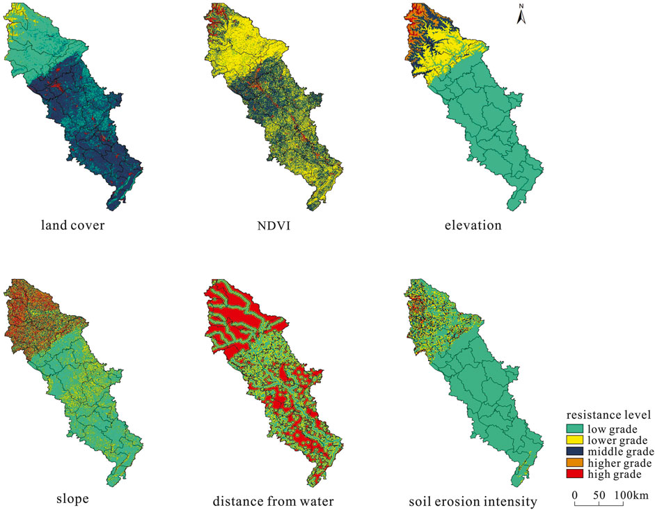
Figure 3. Foundation resistance surface factors in Fujiang River Basin.
Natural factors serve as the basic factors affecting the survival and migration of species, and the interference of human disturbance and landscape ecological risk on the ecological process of the study area could not be ignored. Therefore, it was necessary to correct the basic resistance surface (Figure 4a) from two aspects of human footprint and ecological risk. In the middle and lower reaches of the Fujiang River Basin, the population was dense, with rapid urban expansion High-intensity human activities have significantly changed the biological habitat environment, resulting in the degradation of regional ecosystem service functions, blocking original corridors, and reducing the connectivity of the ecological network (Figure 4b). Because the construction land and human activity sites were mainly concentrated in the plain and hilly areas in the middle and lower reaches of the basin, the habitat patches in the region were fragmented, and the anti-interference ability, as well as the capacity to support biological migration and energy flow, were weakened (Figure 4c). The negative interference surface obtained by the superposition of human footprint and landscape ecological risk was divided into five levels (natural breakpoint method). The upper reaches of the Fujiang River with a relatively intact natural ecology were mainly dominated by low negative interference and lower negative interference. Meanwhile, the high negative interference area was concentrated in the middle and lower reaches of the river basin with strong human disturbance and relatively high ecological risk (Figure 4d).
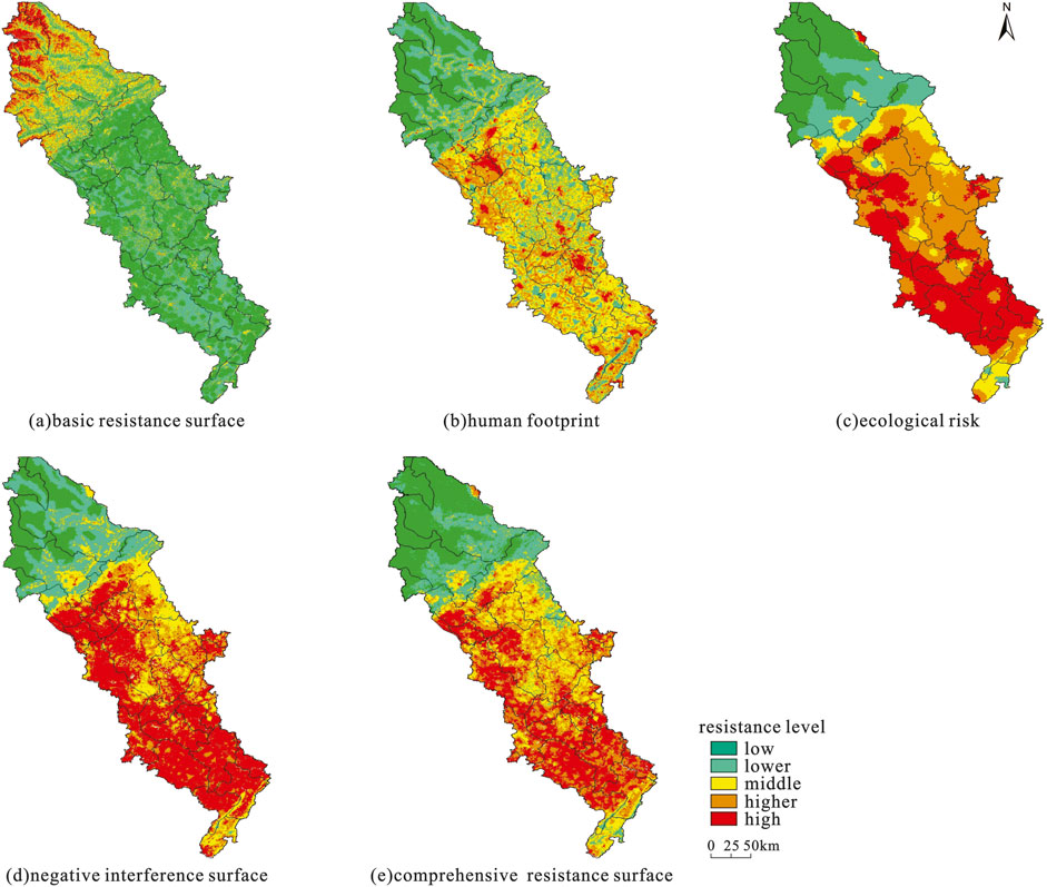
Figure 4. Comprehensive resistance surface of the Fujiang River Basin. (a) basic resistance surface. (b) human footprint. (c) ecological risk. (d) negative interference surface. (e) comprehensive resistance surface.
5.3 Construction of ecological security network
5.3.1 Extraction of ecological corridors and ecological nodes
According to the ecological source and comprehensive resistance surface of the Fujiang River Basin (Figure 4e), the minimum cumulative consumption path from each ecological source to other ecological sources was calculated, and 39 ecological corridors were identified, for a total length of 2348.44 km (Figure 5a). The distribution of ecological corridors in the study area was affected by factors such as the spatial location of the source area and type of land cover. Overall, it presented a cobweb pattern with dense corridors in the north and sparse corridors in the south-central part. Because the ecological sources of the Fujiang River Basin were mainly concentrated in the southern and northern ends of the basin, three main ecological corridors connected the southern and northern sources. Among these, the corridor along the main stream of the Fujiang River had the longest extension distance of 391.29 km (the other two were similar in length at 343.75 km and 337.78 km, respectively). When extracting ecological corridors in the study area, the location overlap rate of the corridor along the main stream of the Fujiang River was high, indicating that it had high utilization rate in the process of biological migration, energy, and information flow. The main reason was that the main stream of the Fujiang River had relatively small resistance to species migration, and the woodland, shrubs, wetlands, and high-coverage grasslands distributed along the river channel provided temporary habitats for species migration.
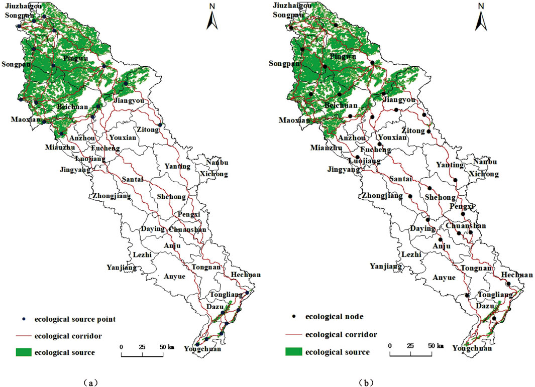
Figure 5. Ecological corridors and ecological nodes in the Fujiang River Basin. (a) ecological corridors (b) ecological nodes.
As mentioned above, the ecological node was the stepping stone in the ecological corridor, and the temporary resting point for the migration and flow of ecological elements between the source areas. As shown in Figures 4e, 5b, the 26 nodes extracted by the superposition of the comprehensive resistance surface “valley line” and the ecological corridor all fell into the area with relatively low ecological resistance along the corridor, becoming a temporary habitat for species migration. The identification and protection of ecological nodes could reduce the obstructive effects of urban construction land, industrial and mining land, and transportation land in the process of species diffusion, thus enhancing the function of ecological corridors.
5.3.2 Construction of the “one corridor and two areas” ecological network
The theory of ecological security network emphasizes the existence of certain potential key areas and key spatial connections in the landscape, which are critical for maintaining ecological processes, including ecological sources as the core area of biological habitats, potential corridors connecting ecological sources, and ecological nodes that offer temporary rest points for biological migration. As shown in Figure 5b, the cobweb-like ecological corridors connected the ecological sources at the north and south ends of the study area, and the ecological nodes were scattered in the low resistance areas along the corridors, thus forming an ecological security pattern in the Fujiang River Basin with ecological sources serving as “key patches,” the ecological corridors as the “axes,” and the ecological nodes as the “hubs.” Based on the ecological security pattern of source-corridor network and habitat connection, this study proposed the ecological construction idea of “one corridor and two zones” (Figure 6) to promote the overall improvement of the ecosystem service functions in the Fujiang River Basin. The one corridor referred to the ecological water corridor of the Fujiang River, making it the longest corridor in the research area that spreads along the main stream of the Fujiang River and connects the ecological sources in the north and south. It has become the main channel for long-distance migration of organisms between the upper and lower reaches of the Fujiang River, making it critical for protecting biodiversity and maintaining regional ecological security. For the ecological water corridor of the Fujiang River, the development intensity along the banks should be strictly controlled, and protective forests along the main stream should be built to make it an ecological barrier along the Fujiang River water corridor, providing low-resistance channels for species migration and reproduction. The “two areas” in this study mainly referred to the ecological source area of the eastern margin of the Qinghai-Tibet Plateau located in the upper reaches of the Fujiang River and the ecological source area of the parallel mountains in eastern Sichuan located in the lower reaches of the Fujiang River. The ecological status of the two zones was deemed suitable for biological habitat. Therefore, the development and construction intensity of the two zones should be strictly controlled, and the protection of natural forests and natural ecosystems should be strengthened to provide high-quality habitats for animals and plants.
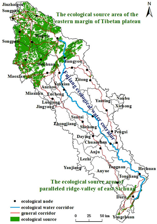
Figure 6. Ecological network of one corridor and two areas in the Fujiang River Basin.
6 Identification of priority areas for ecological restoration and restoration strategies
6.1 Identification of priority areas for ecological restoration
The ecological source areas that were subjected to moderate or above negative disturbances in the ecological network were identified as the priority areas for ecological source restoration in the Fujiang River Basin. Their area accounted for 7.59% of the total area of the ecological source areas. These areas were concentrated in the parallel mountain range area in eastern Sichuan in the southern section of the study area and were relatively scattered in the mountainous area on the eastern edge of the Qinghai-Tibet Plateau in the northern section of the study area (Figure 7). Specifically, the priority areas for ecological source restoration were mainly located in Anzhou District, Jiangyou City, Pingwu County, and Beichuan County under the jurisdiction of Mianyang City, Tongliang District, Yongchuan District, and Dazu District under the jurisdiction of Chongqing City. Overall, the area of ecological sources in the study area that was negatively disturbed was not large, which reflected the effectiveness and rationality of the ecological protection measures on the eastern edge of the Qinghai-Tibet Plateau based on the concept of respecting nature, conforming to nature, and protecting nature” However, in the parallel ridge and valley ecological area in eastern Sichuan, it was still necessary to strengthen ecological protection supervision.
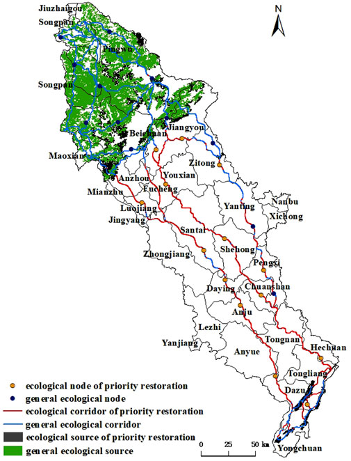
Figure 7. Priority areas for ecological restoration in the Fujiang River Basin.
The middle and lower reaches of the Fujiang River Basin were the transfer and distribution areas of ecological processes between the southern and northern ecological source areas. Many corridors were located between the sources, and the surface cover types were mainly construction land and cultivated land. The higher-level and high-level negative interference surfaces were spatially superimposed with the ecological corridors. The length of the corridors above this negative interference surface was 836.89 km (total length of the corridors was 2,348.44 km), accounting for 35.64% of the total length of the ecological corridors. The main reason was that the region was located in the Chengdu-Chongqing twin-city economic circle, with a large population and high level of economic development, which led to the strong interference of humans on the natural ecological system, fragmentation of the habitat, and significant resistance to ecological processes such as material circulation and energy conversion. Therefore, the length of the priority restoration section of the ecological corridor was relatively long.
Similar to the distribution characteristics of the priority restoration sections of the ecological corridors, 14 priority restoration areas of ecological nodes were identified (total of 26 nodes), accounting for 53.85% of the total number of nodes. The urban construction and the expansion of the transportation network in the middle and lower reaches of the Fujiang River Basin revealed an enhanced breadth and depth of human interference with the natural ecosystem, making the habitat patches more fragmented and further hindering the horizontal ecological process of the landscape ecological flow. Therefore, it was necessary to focus on the construction of ecological nodes in this area and the improvement of ecological functions.
6.2 Ecological restoration priority area restoration strategy
The Fujiang River originates from Xuebaoding, the main peak of Minshan Mountain, flows through the hills and plains of the Sichuan Basin, and flows into Jialing River in Chongqing. The Fujiang River is a cross-border river between Sichuan Province and Chongqing City. Therefore, to restore the priority areas for ecological restoration in the Fujiang River Basin, it is necessary to enhance cross-regional collaboration and jointly build an “ecological community” in the Fujiang River Basin, so as to make the Fujiang River Basin a green background for the construction of the Chengdu-Chongqing Economic Circle. Considering the ecological base and spatial distribution of constituent elements of ecological security pattern in the study area, the targeted restoration strategies were proposed from three perspectives: point (ecological nodes), line (ecological corridors) and surface (ecological sources).
From the perspective of regional distribution, the priority restoration area of the ecological sources is mainly located in the eastern margin of the Qinghai-Tibet Plateau in Sichuan Province and parallel ridges and valleys of eastern Sichuan in Chongqing City. In terms of restoring ecological sources, restricting human disturbances and promoting the improvement of ecological functions are considered keys to restoration, Sichuan and Chongqing should jointly carry out ecological restoration. Therefore, it is necessary to control the development and construction activities that do not conform to the main function orientation in the eastern margin of the Qinghai-Tibet Plateau and parallel ridges and valleys of eastern Sichuan, as well as increase the intensity of natural afforestation, maintain the original topography, enhance the ecosystem service functions such as water conservation, soil and water conservation, habitat protection, wind prevention and sand fixation, and build the eastern margin of the Qinghai-Tibet Plateau into a national ecological security barrier. By consulting the relevant literature (Yang and Bi, 2019), we found that the main reason for the centralized connection of ecological restoration areas in parallel ridges and valleys of eastern Sichuan was that individual mines had not been effectively restored and treated after shutdown, weakening the eco-environmental carrying capacity. Issues were still present, including the illegal expansion of housing, destruction of the environment by private construction, and the illegal occupation of forest land, resulting in a decline in forest coverage, intensified soil erosion, relatively serious non-point source pollution, and the destruction of forest vegetation ecology. Therefore, the ecological restoration of the parallel ridge-valley region in eastern Sichuan should focus on the ecological elements of mountains and forests, adopt the mode of “restoration + conservation,” and focus on promoting mine geological environment restoration measures such as green restoration and land reclamation in mining areas, The ecological restoration of the region should also concentrate on the layout and implementation of national greening projects, artificial afforestation and forest tending, and the maintenance of forest biodiversity.
The priority restoration area of the ecological corridor is mainly located in the urban area and farmland distribution area with strong human disturbance intensity in the middle and lower reaches of the Fujiang River Basin. The region spans multiple districts and counties in Sichuan Province and Chongqing City. This region is also a key area for Sichuan and Chongqing to carry out ecological co-protection, ecological co-construction and ecological co-sharing. With the continuous advancement of the construction of the Chengdu-Chongqing Economic Circle, the cooperation between the two places in the ecological field has risen from the initial exploration of the working mechanism to the collaborative legislation and integrated advancement. The two regions have been making continuous efforts in top-level design and coordinated development, actively building and jointly creating a green and low-carbon economic circle. In terms of ecological corridor restoration, Sichuan Province and Chongqing City should break the regional boundaries and create a linkage mechanism. Ecological planning should be strengthened in this area to rationally guide the direction of urban development and avoid disorderly urban expansion. In urban built-up areas, green space is typically built through afforestation, ecological barriers are removed, and ecological circulation is guaranteed. Therefore, for non-basic farmland sloping farmland, measures of returning farmland to forest and grassland should be implemented, and soil stabilization and slope protection should be carried out to prevent soil erosion. For corridors along the river, continuous efforts should be made to control river pollution, improve management of the riverbank, and rectify the phenomenon of small, scattered, and disorderly industrial sewage discharge along the river to maintain water environmental safety from the source. In addition, the protection of wetlands along the river should be strengthened to maintain the integrity and connectivity of the river ecosystem.
Similar to the distribution characteristics of the priority restoration areas of ecological corridors, ecological nodes that require priority restoration were found to be mainly located in the distribution areas of towns and cultivated land in the middle and lower reaches of the river basin where human activities were significantly disturbed. For the restoration of ecological nodes, Sichuan Province and Chongqing City should comprehensively consider the integrity of ecosystems and natural geographical units, break the administrative boundaries, promote coordinately the ecological protection of upstream and downstream, trunk and tributaries with systematic thinking, and clarify the main direction of ecological node restoration. To improve the ecological environment around the temporary rest points of migratory organisms along ecological corridors, artificial afforestation should be carried out in urban built-up areas based on the ecological adaptability and growth laws of trees. Sloping farmland prone to soil erosion should limit farming incrementally, and forest vegetation should be restored in accordance with local conditions to provide temporary habitats for species migration, reducing species migration resistance and improving corridor connectivity. For ecological nodes along the river corridor, in addition to building protective forests along the main stream, efforts should focus on the land restoration and greening improvement of the central and side beaches, and soil and water conservation in the tidal flat areas should be intensified. Thus, a stable wetland ecosystem should be established, making wetlands a stepping stone for species migration.
7 Discussion and conclusion
7.1 Discussion
The purpose of constructing an ecological security network involves ensuring the integrity of the natural ecological structure in the Fujiang River Basin, offering ecosystem service functionality, and providing an ecological barrier for the sustainable development of the social economy. The ecological security theory states that a series of key factors exist in the ecological network, and their spatial locations and interrelationships play an important role in maintaining regional ecological processes (Roche and Campagne, 2017; Yu et al., 2021; Wu et al., 2024). Ecological sources, ecological corridors, and ecological nodes serve as the main components of ecological security networks.In the selection of ecological sources, previous researchers usually use large areas of concentrated contiguous forest land, waters (Li et al., 2019; Li et al., 2020; Wu et al., 2021; Gao et al., 2023) and nature reserves (Li et al., 2011; Yan et al., 2025) as ecological sources. This method is highly convenient, but ignores the internal spatial differences of the same land type. This study selects indicators such as water conservation, soil and water conservation, and habitat quality to quantitatively evaluate the supply capacity of ecosystem services, and combined with the evaluation of landscape connectivity, it can effectively assess the ecological quality of patches and avoid the inaccuracy of extracting ecological sources from a single indicator. Compared with the previous methods of identifying ecological corridors such as the patch gravity model (Liu et al., 2021; Fan et al., 2022; Yao et al., 2023) and the comprehensive evaluation index system (Zhang et al., 2009), the minimum cumulative resistance model (MCR) used in this study can better simulate the obstructive effect of the landscape on the spatial movement process, and better express the interaction relationship between the landscape pattern and the ecological process. The key of quantitative identification of ecological corridors is the setting of ecological resistance surface. Most early studies were based on land cover types and directly assigned values according to expert consultation scores (Kong and Yin, 2008; Li et al., 2011; Xu et al., 2012; Peng et al., 2017). The uniform assignment based on land cover types will inevitably mask the differences in ecological resistance of different land use patterns under the same land cover type. The basin ecosystem is a special “natural-social” landscape complex. According to the ecological status of the Fujiang River Basin, this study selects indicators from the three dimensions of natural factors, human footprint and landscape ecological risk as the evaluation factors of the ecological resistance surface, so as to make the construction of the ecological resistance surface in the study area more comprehensive. Studies have shown that human activities such as urban construction land and agricultural land expansion have an important impact on the landscape pattern of the basin. The ecological resistance of construction land and cultivated land distribution areas with low vegetation coverage is relatively large, and the distribution of sources and corridors is sparse. The research results are basically consistent with previous studies (Chen et al., 2012; Ding et al., 2024; Deng et al., 2024; Li Y. et al., 2025; Fu et al., 2025). In terms of the identification of ecological restoration priority areas, based on the consideration of “maintaining ecological pinch points and removing ecological obstacle points to ensure the normal migration of species,” predecessors often regarded ecological pinch points and ecological obstacle points as ecological restoration priority areas, or directly identified the ecological network components (ecological sources and ecological corridors) as ecological restoration priority areas. The above division methods ignore the internal differences of ecological resistance of the same type of patches. In this study, the ecological network and the negative interference surface are superposed and analyzed. The areas with higher negative interference in the ecological network are identified as the priority areas of ecological restoration. The negative interference of the priority areas of ecological restoration can be eliminated through ecological restoration measures to maintain the connectivity of the entire ecological network.
This study took the Fujiang River Basin as a whole to construct an ecological security network and obtain contiguous ecological source areas belonging to different municipal regions. The ecological source areas in the northern part of the study area were mainly located in the county units under the jurisdiction of the Aba prefecture and Mianyang city, while those in the southern part of the study area were mainly located in the administrative regions under the jurisdiction of Chongqing City. If the ecological security pattern was constructed according to administrative divisions, the complete contiguous ecological sources could be artificially separated, thus ignoring the identification of key ecological corridors with connectivity significance. The significance of this research was in constructing an overall ecological security network framework for the overall Fujiang River Basin. Each small area (tributary river basin or municipal and county units) could further identify and construct the ecological security network belonging to each small area based on the local natural environment characteristics and social development level without disrupting the integrity of the ecological security pattern.
This research mainly used relevant data from 2023 to identify ecological sources, simulate ecological corridors, and extract ecological nodes. However, we did not analyze the dynamic changes in ecological security patterns on the historical time scale. We plan to construct a multi-time scale ecological security network, and explore its spatial and temporal change trend and the driving mechanism of the evolution of the landscape ecological pattern. Based on the importance of ecosystem services and MCR model, the sources, corridors and nodes could be extracted, and the priority areas of ecological restoration were identified via superposition of negative interference surface and ecological network, and an ecological restoration strategy was proposed. However, the theoretical restoration measures could differ from actual restoration operations. In the future, it may be necessary to combine the field verification data with the model data, making it more conducive to the accurate identification of each ecological network element, and to enhance the feasibility of engineering restoration measures and biological restoration measures. As the cornerstone of constructing ecological security network, ecological sources are the starting point of species diffusion. However, the extraction method of ecological sources remains in the exploratory stage. Different researchers have their own advantages and disadvantages in identifying ecological sources from multiple perspectives. This study did not attempt to use a variety of methods to identify ecological source patches and compare methods. In future research, methods such as morphological spatial pattern analysis, direct identification of ecological protection red lines, and comprehensive superposition of various factors will be proposed to serve as the basis for extracting ecological sources. In future research, we will propose using morphological spatial pattern analysis, the direct identification of ecological protection red lines, and the comprehensive superposition of various factors as the basis for the extraction of ecological sources. These will be compared with ecological sources extracted based on the evaluation results of the importance of ecosystem services (the method adopted in this study).
7.2 Conclusion
The construction of ecological security networks serves as one of the important strategies for ensuring regional ecological security, coordinating contradiction between economic and social development and ecosystem, and improving human wellbeing. Taking the Fujiang River Basin as the research area, the ecological source was identified through the evaluation of the importance of ecosystem services, and the ecological corridors and ecological nodes were extracted based on the minimum cumulative resistance model. The ecological security network of the Fujiang River Basin was constructed from three dimensions: point (ecological nodes), line (ecological corridors), and surface (ecological sources). The ecological network and the negative interference surface were spatially superimposed to identify the priority areas of ecological restoration and propose corresponding ecological restoration strategies. The main conclusions of this study were as follows.
1. The ecological sources of the Fujiang River Basin are concentrated in the mountainous areas on the eastern edge of the Qinghai-Tibet Plateau, and scattered in the parallel mountain areas of eastern Sichuan. Ecological source areas provide ecological supply services such as water conservation, soil and water conservation, and biological habitat for the research area, ensuring the integrity of the ecosystem structure. With the rapid development of urban construction in the Fujiang River Basin, frequent economic activities have had an impact on the land use structure and ecological environment. Against the background, the protection and restoration of ecological source areas should be further strengthened.
2. Evaluation indicators were selected from three dimensions: natural element, human footprint, and landscape ecological risk to construct and correct the ecological resistance surface. The high-value areas of ecological resistance are mainly distributed in impervious surface areas such as urban construction land and cultivated land with strong artificial transformation. Subsequent ecological construction needs to enhance the habitat suitability and landscape connectivity of the high-value areas of resistance, and further build a complete ecological network.
3. Based on the ecological resistance surface of the Fujiang River Basin, the ecological corridors extracted by the cost path tool connect the two ecological sources located at the north and south ends of the study area and far away from each other. The ecological nodes distributed along the corridors reduce the risk of the ecological corridors being blocked, provide temporary rest places for the migration and flow of ecological elements between source areas, and have positive significance for the maintenance and protection of the ecological corridors. Based on the ecological network of sources and corridors forming networks, habitat connectivity, the ecological construction idea of “one corridor and two areas” (It is composed of the ecological water corridor of the Fujiang River and the ecological sources located at the south and north ends of the study area) was proposed.
4. Based on the spatial superposition of negative interference surface and ecological security network, the priority areas of ecological restoration are identified. Fujiang River is a cross-border river in Sichuan Province and Chongqing City. In terms of ecological restoration, cross-regional cooperation should be strengthened from the strategic perspective of Chengdu-Chongqing Economic Circle construction, and ecological restoration priority areas should be repaired from the aspects of limiting human disturbance, removing ecological obstacles, ensuring landscape connectivity, and implementing land greening projects.
Data availability statement
The original contributions presented in the study are included in the article/supplementary material, further inquiries can be directed to the corresponding author.
Author contributions
HC: Conceptualization, Writing – original draft. YW: Methodology, Writing – review and editing. ZC: Validation, Writing – review and editing. LM: Data curation, Software, Writing – review and editing.
Funding
The author(s) declare that financial support was received for the research and/or publication of this article. This research was supported by the Science and Technology Plan Project of Sichuan Provincial Department of Science and Technology (Construction of Ecological Security Pattern and the Identification of Priority Areas for Ecological Restoration in Fujiang River Basin) (NO. 2025ZNSFSC0257).
Conflict of interest
The authors declare that the research was conducted in the absence of any commercial or financial relationships that could be construed as a potential conflict of interest.
Generative AI statement
The author(s) declare that no Generative AI was used in the creation of this manuscript.
Any alternative text (alt text) provided alongside figures in this article has been generated by Frontiers with the support of artificial intelligence and reasonable efforts have been made to ensure accuracy, including review by the authors wherever possible. If you identify any issues, please contact us.
Publisher’s note
All claims expressed in this article are solely those of the authors and do not necessarily represent those of their affiliated organizations, or those of the publisher, the editors and the reviewers. Any product that may be evaluated in this article, or claim that may be made by its manufacturer, is not guaranteed or endorsed by the publisher.
References
Chen, B. L., Liu, X., and Liu, J. P. (2025). Construction and optimization of ecological security patterns in Chinese Black soil areas considering ecological importance and vulnerability. Sci. Rep. 15, 12142. doi:10.1038/s41598-025-95927-6
Chen, X. Y., Xie, G. Z., and Zhang, J. P. (2012). Landscape ecological risk assessment of land use changes in the coastal area of haikou city in the past 30 years. Acta Ecol. Sin. 41 (3), 975–986. doi:10.5846/stxb201909211974
Chen, W. D., Zhao, J. S., Chen, G. P., Lin, Y. L., Yang, H. B., and Chen, Q. X. (2025). Ecological network optimization and security pattern development for Kunming’s main urban area using the MSPA-MCR model. Sustainability 17 (8), 3623. doi:10.3390/su17083623
Deng, C. X., Gong, Y. J., Zhang, G. J., Liu, C. C., and Wang, Y. X. (2024). Construction of an ecological security pattern in xiangjiang river basin based on landscape ecological risk assessment. Bull. Soil Water Conserv. 44 (3), 145–158.
Ding, J. H., Wang, D. Q., and Qian, J. (2024). Landscape ecological risk assessment and ecological security pattern construction in the southern Jiangsu water network area under the urban expansion scenario simulation: a case study of the Baixian lake area in Suzhou. Resour. Environ. Yangtze Basin 33 (9), 2059–2070. doi:10.11870/cjlyzyyhj202409018
Du, L. D., Dong, C., Kang, X. C., Qian, X. L., and Gu, L. X. (2023). Spatiotemporal evolution of land cover changes and landscape ecological risk assessment in the Yellow river basin, 2015–2020. J. Environ. Manage. 332, 117149. doi:10.1016/j.jenvman.2022.117149
Du, S., Xu, D. Z., Sun, F. Y., and Dong, X. Y. (2024). Identification of key areas for territorial ecological restoration: focusing on ecological security and restoration potential. Front. Environ. Sci. 12, 1463683. doi:10.3389/fenvs.2024.1463683
Fan, C. M., Wang, Z. T., Tang, N., and Deng, G. P. (2022). Construction of ecological network in downtown of Guiyang city based on morphologically spatial pattern and spatially principal component analysis. Acta Ecol. Sin. 42 (16), 6620–6632. doi:10.5846/stxb202012213241
Feng, X. Q., Du, Z. Y., Tao, P. Y., Liang, H. Q., Wang, Y. Z., and Wang, X. (2024). Construction of green space ecological network in Xiongan new area based on the MSPA–InVEST–MCR model. Appl. Sci. 14 (22), 10760. doi:10.3390/app142210760
Fu, L., Peng, S. Y., Gong, L. P., Huang, B. M., Ma, D. L., and Zhu, Z. Y. (2025). Analysis of the construction and evolution of ecological security patterns in karst areas. J. Soil Water Conserv. 39 (2), 218–229. doi:10.13870/j.cnki.stbcxb.2025.02.005
Gao, X., Song, Z. Y., Li, C. X., and Tang, H. Z. (2023). Landscape pattern optimization in Baiyangdian basin based on landscape ecological risk assessment. J. Ecol. Rural. Environ. 39 (2), 174–183. doi:10.19741/j.issn.1673-4831.2021.0796
Gou, R., Su, W. C., and Huang, X. F. (2024). Construction of ecological security network and multi-scenario simulation in Guizhou province based on landscape ecological security assessmen. Environ. Sci. 46, 4580–4591. doi:10.13227/j.hjkx.202406286
Guo, H. J., Cai, Y. P., Li, B. W., Wan, H., and Yang, Z. F. (2023). An improved approach for evaluating landscape ecological risks and exploring its coupling coordination with ecosystem services. J. Environ. Manage. 348, 119277. doi:10.1016/j.jenvman.2023.119277
Guo, Y. T., Wang, W., Zhang, X. T., Liu, C., Wang, Y. X., Chen, W. Q., et al. (2025). Revealing the impact of urbanization on landscape ecological risk: a case study of the lower reaches of the Yangtze river, China. Front. Environ. Sci. 13, 1589832. doi:10.3389/fenvs.2025.1589832
Hao, R. F., Yu, D. Y., Liu, Y. P., Liu, Y., Qiao, J. M., Wang, X., et al. (2017). Impacts of changes in climate and landscape pattern on ecosystem services. Sci. Total Environ. 579, 718–728. doi:10.1016/j.scitotenv.2016.11.036
He, J. H., Huang, J. L., and Li, C. (2017). The evaluation for the impact of land use change on habitat quality: a joint contribution of cellular automata scenario simulation and habitat quality assessment model. Ecol. Model. 366, 58–67. doi:10.1016/j.ecolmodel.2017.10.001
Hu, J. Q., Jiao, S., Xia, H., and Qian, Q. (2023). Construction of rural multifunctional landscape corridor based on MSPA and MCR model—taking Liukeng cultural and ecological tourism area as an example. Sustainability 15 (16), 12262. doi:10.3390/su151612262
Ju, H. R., Niu, C. Y., Zhang, S. R., Jiang, W., Zhang, Z. H., Zhang, X. L., et al. (2021). Spatiotemporal patterns and modifiable areal unit problems of the landscape ecological risk in coastal areas: a case study of the Shandong peninsula, China. J.Clean. Prod. 310, 127522. doi:10.1016/j.jclepro.2021.127522
Kedron, P. J., Frazier, A. E., Ovando-Montejo, G. A., and Wang, J. (2018). Surface metrics for landscape ecology: a comparison of landscape models across ecoregions and scales. Landsc. Ecol. 33, 1489–1504. doi:10.1007/s10980-018-0685-1
Kong, F. H., and Yin, H. W. (2008). Developing green space ecological networks in Jinan city. Acta Ecol. Sin. 28 (4), 1711–1719. doi:10.3321/j.issn:1000-0933.2008.04.042
Lausch, A., Blaschke, T., Haase, D., Herzog, F., Syrbe, R. U., Tischendorf, L., et al. (2015). Understanding and quantifying landscape structure–a review on relevant process characteristics, data models and landscape metrics. Ecol. Model. 295, 31–41. doi:10.1016/j.ecolmodel.2014.08.018
Li, H., Yi, N., Yao, W. J., Wang, S. Q., Li, Z. Y., and Yang, S. H. (2011). Shangri-La county ecological land use planning based on landscape security pattern. Acta Ecol. Sin. 31 (20), 5928–5936.
Li, Q. P., Zhang, Z. D., Wan, L. W., Yang, C. X., Zhang, J., Ye, C., et al. (2019). Landscape pattern optimization in Ningjiang river basin based on landscape ecological risk assessment. Acta geo. Sin. 74 (7), 1420–1437. doi:10.11821/dlxb201907011
Li, H. H., Ma, T. H., Wang, K., Tan, M., and Qu, J. F. (2020). Construction of ecological security pattern in northern Peixian based on MCR and SPCA. J. Ecol. Rural. Environ. 36 (8), 1036–1045. doi:10.19741/j.issn.1673-4831.2020.0100
Li, G. D., Fang, C. L., Li, Y. J., Wang, Z. B., Sun, S., He, S. W., et al. (2022). Global impacts of future urban expansion on terrestrial vertebrate diversity. Nat. Commun. 13, 1628. doi:10.1038/s41467-022-29324-2
Li, K. X., Zhang, L., Li, H., Zhang, E. Y., Li, Y. Z., Song, C. Y., et al. (2024a). Identification of the key regions of spatial ecological restoration in the northwest Shanxi based on the MSPA model and circuit theory. Arid. Zone Rsch 41 (9), 1593–1604. doi:10.13866/j.azr.2024.09.15
Li, M. R., Abuduwaili, J., Liu, W., Feng, S., Saparov, G., and Ma, L. (2024b). Application of geographical detector and geographically weighted regression for assessing landscape ecological risk in the Irtysh river basin, central Asia. Ecol. Indic. 158, 111540. doi:10.1016/j.ecolind.2023.111540
Li, Z., Liu, J. C., Ma, R. Q., Xie, W. H., Zhao, X. Y., Wang, Z. H., et al. (2024c). Construction of ecological security pattern based on ecosystem services, sensitivity, connectivity, and resistance—a case study in the huang-huai-hai plain. Land 13 (12), 2243. doi:10.3390/land13122243
Li, X. D., Tao, H. Y., Wang, J., Zhang, B., Liu, Z., Liu, Z. P., et al. (2025). Integrated evaluation of the ecological security pattern in central Beijing using InVEST, MSPA, and Multifactor Indices. Land 14 (1), 205. doi:10.3390/land14010205
Li, Y., Liu, J. L., Li, J. J., Yang, C. Y., and Luo, G. J. (2025). Construction of an ecological security pattern in karst watersheds based on ecological corridor identification:a case study of the Nanming river basin in Guizhou. Environ. Sci. 46 (5), 3098–3113. doi:10.13227/j.hjkx.202404038
Lin, X., and Wang, Z. T. (2023). Landscape ecological risk assessment and its driving factors of multi-mountainous city. Ecol. Indic. 146, 109823. doi:10.1016/J.ECOLIND.2022.109823
Lin, J. Q., Yang, W. F., Yu, K. Y., Geng, J. W., and Liu, J. (2022). Identification and construction of ecological nodes in the Fuzhou ecological corridors. For 13 (11), 1837. doi:10.3390/f13111837
Liu, S. L., Dong, Y. H., Sun, Y. X., and Shi, F. N. (2019). Priority area of mountains-rivers-forests-farmlands-lakes-grasslands based on the improvement of ecosystem services: a case study of Guizhou Province. Acta Ecol. Sin. 39 (23), 8957–8965. doi:10.5846/stxb201905301140
Liu, J. L., Li, S. P., Fan, S. L., and Hu, Y. (2021). Identification of territorial ecological protection and restoration areas and early warning places based on ecological security pattern: a case study in xiamen-zhangzhou-quanzhou region. Acta Ecol. Sin. 41 (20), 8124–8134. doi:10.5846/stxb202012013074
Liu, S. L., Wang, Q. B., Miao, C. Y., Dong, Y. H., Sun, Y. X., and Yu, L. (2024). Ecological security patterns of water conservation in the upper reaches of the Yellow river basin (Sichuan section) with ecological network approach. J. Beijing Norm. Univ. Nat. Sci. 60 (3), 418–426. doi:10.12202/j.0476-0301.2023137
Liu, M. G., Wang, Q., Liang, G. M., Liu, M. M., Hu, X. S., Lin, S., et al. (2025). Construction of an ecological security pattern based on the PLUS and MSPA models: a case study of the Fuzhou metropolitan area. Sustainability 17, 5830. doi:10.3390/su17135830
Liu H, H. L., Wang, Z. L., Zhang, L. P., Tang, F., Wang, G. Y., and Li, M. (2023). Construction of an ecological security network in the fenhe river basin and its temporal and spatial evolution characteristics. J. Clean. Prod. 417, 137961. doi:10.1016/j.jclepro.2023.137961
Liu X, X. Y., Su, Y., Li, Z. G., and Zhang, S. (2023). Constructing ecological security patterns based on ecosystem services trade-offs and ecological sensitivity: a case study of shenzhen metropolitan area, China. Ecol. Indic. 154, 110626. doi:10.1016/j.ecolind.2023.110626
Ma, S. F., Lao, C. H., and Jiang, H. Y. (2021). Ecological restoration zoning of territorial space based on the pattern simulation of eco-security scenario:a case study of guangdong-Hong Kong-Macao greater bay area. Acta Ecol. Sin. 41 (9), 3441–3448. doi:10.5846/stxb202003290741
Masoudi, M., Richards, D. R., and Tan, P. Y. (2024). Assessment of the influence of spatial scale and type of land cover on urban landscape pattern analysis using landscape. Metrics. J. Geovis. Spat. Anal. 8 (1), 1–16. doi:10.1007/s41651-024-00170-8
Niu, X. N., Zhang, J., Wang, S. X., Zong, L. L., Zhou, M., and Zhang, M. (2025). Identification of priority areas for ecological restoration based on ecological security patterns and ecological risks: a case study of the hefei metropolitan area. Ecol. Indic. 175, 113590. doi:10.1016/j.ecolind.2025.113590
Peng, J., Zhao, H. J., Liu, Y. X., and Wu, J. S. (2017). Research progress and prospect on regional ecological security pattern construction. Geogr. Res. 36 (3), 407–419. doi:10.11821/dlyj201703001
Peng, J., Yang, Y., Liu, Y. X., Hu, Y. N., Du, Y. Y., Meersmans, J., et al. (2018). Linking ecosystem services and circuit theory to identify ecological security patterns. Sci. Total Environ. 644, 781–790. doi:10.1016/j.scitotenv.2018.06.292
Qin, J. Z., Dai, J. P., Li, S. H., Zhang, J. Z., and Peng, J. S. (2024). Construction of ecological network in qujing city based on MSPA and MCR models. Sci. Rep. 14, 9800. doi:10.1038/s41598-024-60048-z
Ran, P., Hu, S., Frazier, A. E., Qu, S., Yu, D., and Tong, L. (2022). Exploring changes in landscape ecological risk in the yangtze river economic belt from a spatiotemporal perspective. Ecol. Indic. 137, 108744. doi:10.1016/j.ecolind.2022.108744
Roche, P. K., and Campagne, C. (2017). From ecosystem integrity to ecosystem condition: a continuity of concepts supporting different aspects of ecosystem sustainability. Curr. Opin. Env. Sust. 29, 63–68. doi:10.1016/j.cosust.2017.12.009
Shifaw, E., Sha, J. M., Li, X. M., Bao, Z. C., Ji, J. W., Huang, J. F., et al. (2024). Spatiotemporal dynamics of ecological security pattern based on an optimized assessment framework and circuit theory: a case of fuzhou city, China. Hum. Ecol. Risk Assess. Int. J. 30 (3–4), 352–377. doi:10.1080/10807039.2024.2358317
Song, Y. K., Li, M. G., Duo, L. H., Chen, N. N., Lu, J. P., and Yang, W. Z. (2025). Multi-scenario simulation and assessment of ecological security patterns: a case study of Poyang Lake eco-economic zone. Sustainability 17 (9), 4017. doi:10.3390/su17094017
Tu, Y., Liu, M., Gao, C. C., Sun, Y. W., Cai, C. L., and Su, L. (2022). Construction of ecological sources identification system for metropolitan areas and diagnosis of key areas for ecological restoration in nationally spatial areas. Acta Ecol. Sin. 42 (17), 7056–7067. doi:10.5846/stxb202108272408
Wang, Y., and Pan, J. (2019). Building ecological security patterns based on ecosystem services value reconstruction in an arid inland basin: a case study in ganzhou district, NW China. J. Clean. Prod. 241, 118337. doi:10.1016/j.jclepro.2019.118337
Wang B, B., Fu, S. T., Hao, Z. X., and Zhen, Z. L. (2024). Ecological security pattern based on remote sensing ecological index and circuit theory in the Shanxi section of the Yellow river basin. Ecol. Indic. 166, 112382. doi:10.1016/J.ecolind.2024.112382
Wang, H., Liu, X. M., Zhao, C. Y., Chang, Y. P., Liu, Y. Y., and Zang, F. (2021). Spatial-temporal pattern analysis of landscape ecological risk assessment based on land use/land cover change in Baishuijiang national nature reserve in Gansu province, China. Ecol. Indic. 124, 107454. doi:10.1016/J.ECOLIND.2021.107454
Wang, X. L., Sun, Y. J., Liu, Q. H., and Zhang, L. G. (2023). Construction and optimization of ecological network based on landscape ecological risk assessment: a case study in Jinan. Land 12 (4), 743. doi:10.3390/land12040743
Wang X, X. F., Zhu, M. N., Zhang, X. R., Ma, J. H., Zhou, J. T., Cheng, T., et al. (2024). Ecological security pattern construction of the three-river source region based on source-resistance-corridor. Acta Ecol. Sin. 44 (11), 4609–4623. doi:10.20103/j.stxb.202309282107
Wei, W., Zhang, Y. L., Wei, X. X., Xie, B. B., Ma, Z. Y., Liu, C. Y., et al. (2025). Construction and optimization of ecological security patterns based on ecosystem service function and ecosystem sensitivity in the important ecological functional area-a case study in the Yellow river basin. Ecol. Eng. 215, 107609. doi:10.1016/j.ecoleng.2025.107609
Wu, J. H., Liu, S. Y., and Bai, S. (2021). Identification and optimization of ecological corridors in Shenmu city based on landscape ecological security. Arid. Zone Rsch 38 (4), 1120–1127. doi:10.13866/j.azr.2021.04.24
Wu, X. T., Pan, J. H., and Zhu, X. W. (2024). Optimizing the ecological source area identification method and building ecological corridor using a genetic algorithm: a case study in Weihe river basin, NW China. Ecol. Inf. 80, 102519. doi:10.1016/j.ecoinf.2024.102519
Xiang, A. M., Zhao, X. Q., Huang, P., Yi, Q., Pu, J. W., Shi, X. Y., et al. (2023). Diagnosis and restoration of priority area of territorial ecological restoration in plateau lake watershed. Acta Ecol. Sin. 43 (15), 6143–6153. doi:10.5846/stxb202212283686
Xu, W. W., Sun, X., Zhu, X. D., Zong, Y. G., and Li, Y. F. (2012). Recognition of important ecological nodes based on ecological networks analysis: a case study of urban district of Nanjing. Acta Ecol. Sin. 32 (4), 1264–1272. doi:10.5846/stxb201012241838
Yan, Y. C., Ju, H. R., Zhang, S. G., and Chen, G. K. (2021). The construction of ecological security patterns in coastal areas based on landscape ecological risk assessment-a case study of Jiaodong peninsula, China. Int. J. Environ. Res. Public Health 18, 12249. doi:10.3390/IJERPH182212249
Yan, J. X., Li, J., Yao, X. D., Li, Q., Zheng, Z. Q., Li, G., et al. (2025). Ecological security pattern construction based on landscape ecological risk assessment in the Yellow river basin. Front. Environ. Sci. 13, 1514599. doi:10.3389/fenvs.2025.1514599
Yang, Q. Y., and Bi, G. H. (2019). Research on the pattern and supporting measures of ecological protection and remediation in the ecotope of Ridge and Valley province:based on the pilot project of ecological protection and remediation of “two rivers and four mountains” in Chongqing. Acta Ecol. Sin. 39 (23), 8939–8947. doi:10.5846/stxb201905291122
Yang, N. J., Zhang, T., Li, J. Z., Feng, P., and Yang, N. (2024). Landscape ecological risk assessment and driving factors analysis based on optimal spatial scales in Luan river basin, China. Ecol. Indic. 169, 112821. doi:10.1016/j.ecolind.2024.112821
Yao, C. Y., He, Y. M., Cheng, J. X., Zhang, T. Y., Pan, H. Y., and Ma, H. J. (2023). Evaluation of ecological security pattern and optimization suggestions in Minjiang river basin based on MCR model and gravity model. Acta Ecol. Sin. 43 (17), 7083–7096. doi:10.20103/j.stxb.202209062546
Yu, C. L., Liu, D., Feng, R., Tang, Q., and Guo, C. L. (2021). Construction of ecological security pattern in Northeast China based on MCR model. Acta Ecol. Sin. 41 (1), 290–301. doi:10.5846/stxb201909241998
Zhang, B. B., Cao, J. R., Chen, D. S., Li, X., Liu, Y. J., Wang, J. B., et al. (2024). Construction of watershed ecological security patterns with integrated of spatial variability: a case study of the Yellow river basin, China. Ecol. Indic. 159, 111663. doi:10.1016/j.ecolind.2024.111663
Zhang, X. F., Li, Z. G., Wang, R. S., Wang, Y. L., Li, F., and Xiong, X. X. (2009). Study on network analysis for urban ecological security pattern in Changzhou city. J. Peking. Univ. 45 (4), 728–736. doi:10.13209/j.0479-8023.2009.108
Zhang, X. M., Dong, T. X., Du, H. M., Liao, C. L., and Wang, F. (2021). Optimization of landscape pattern in Fujiang River Basin based on landscape ecological risk assessment. Acta Ecol. Sin. 41 (10), 3940–3951. doi:10.5846/stxb202101040027
Zhang, Q., Sun, Y., Tang, D. W., Cheng, H., and Tu, Y. (2025). Construction and zoning of ecological security patterns in Yichang city. Sustainability 17 (6), 2354. doi:10.3390/su17062354
Zhang, R. C., Hu, M. G., Sheng, A. J., Deng, W., Zhang, S. Y., and Liu, J. (2025). Construction of ecological security network in mountainous transitional geospace using circuit theory and morphological spatial pattern analysis: a case study of Taihang mountain area. Sustainability 17 (4), 1743. doi:10.3390/su17041743
Zhang, S. H., Jiang, H. L., Yu, H. L., Feng, X. H., and Fan, M. X. (2024). Construction of landscape ecological network based on MCR risk assessment model: a case study of Liaoning province, China. Ecol. Indic. 166, 112549. doi:10.1016/J.ECOLIND.2024.112549
Zhang, T. Y., Chen, W. B., Sheng, Z. Y., Wang, P. Q., and Guan, F. Y. (2025). Ecological network construction and identification of important elements based on morphological spatial pattern analysis and circuit theory in Pingxiang city. J. Nat. Conserv. 86, 126902. doi:10.1016/J.JNC.2025.126902
Zhou, Q. Q., Bosch, V. D., Chen, J. R., Zhang, W. B., and Dong, J. W. (2021). Identification of ecological networks and nodes in Fujian province based on green and blue corridors. Sci. Rep. 11, 20872. doi:10.1038/s41598-021-99416-4
Zhou, S. K., Song, Y. H., Li, Y. J., Wang, J., and Zhang, L. (2022). Construction of ecological security pattern for plateau lake based on MSPA–MCR model: a case study of Dianchi lake area. Sustainability 14 (21), 14532. doi:10.3390/su142114532
Keywords: ecological security network, priority areas for ecological restoration, landscape ecological risk, negative interference, Fujiang River Basin
Citation: Chen H, Wang Y, Cheng Z and Ma L (2025) Construction of ecological security networks and the identification of priority areas for ecological restoration in Fujiang River Basin. Front. Environ. Sci. 13:1673214. doi: 10.3389/fenvs.2025.1673214
Received: 25 July 2025; Accepted: 02 September 2025;
Published: 16 September 2025.
Edited by:
Nagai Shin, Japan Agency for Marine-Earth Science and Technology, JapanReviewed by:
Ana Maria Antão-Geraldes, Instituto Politécnico de Braganča, PortugalAokang Xu, Northwest University, China
Copyright © 2025 Chen, Wang, Cheng and Ma. This is an open-access article distributed under the terms of the Creative Commons Attribution License (CC BY). The use, distribution or reproduction in other forums is permitted, provided the original author(s) and the copyright owner(s) are credited and that the original publication in this journal is cited, in accordance with accepted academic practice. No use, distribution or reproduction is permitted which does not comply with these terms.
*Correspondence: Li Ma, ODQwNjM4MjVAcXEuY29t