 Anna Dabros
 Effah Kwabena Antwi
 Celina Waldron
 Akua Nyamekye Darko
 Kellina L. Higgins1
- 1Natural Resources Canada, Canadian Forest Service, Northern Forestry Centre, Edmonton, AB, Canada
- 2Natural Resources Canada, Canadian Forest Service, Ottawa, ON, Canada
- 3Renewable Resources Department, University of Alberta, Edmonton, AB, Canada
The Ring of Fire (RoF) region in northeastern Ontario, Canada, is an emerging mining frontier rich in critical minerals including nickel, chromite, and copper. The RoF lies within Treaty No. 9 territory and is home to several Indigenous First Nations, including Marten Falls, Webequie, and Neskantaga. While promising significant economic benefits, the future development poses various environmental risks, and concerns about Indigenous consultation and consent. The RoF is found in the Hudson Bay Lowlands (HBL), one of the world’s largest peatland complexes that cover 90% of the HBL landscape. These peatlands play crucial roles in carbon storage, water regulation, and biodiversity maintenance. The region’s remoteness—540 km from urban centers and lacking all-season road access—requires development of significant infrastructure such as roads, airstrips, and transmission lines. In this review, researchers used the Bowtie Risk Assessment Tool (BRAT) to analyze environmental risks, focusing on planned construction of three major all-season roads and resulting peatland disturbance. Two primary threats emerged: (1) peatland drainage causing habitat loss (including for threatened species like woodland caribou), wildfire risk, and increased carbon emissions; (2) linear infrastructure impact such as edge effects, invasive species, hydrological alterations, and permafrost degradation. Climate change may exacerbate these effects, increasing risk of drought and wildfire. Preventive and mitigation strategies involve habitat protection, clustering infrastructure, optimized road construction, construction and maintenance of culverts, invasive species control, and wildfire management. In conclusion, while mining development in the RoF region could boost the economy, it poses significant threats to one of the world’s largest peatlands, risking increased carbon release and biodiversity loss. Indigenous communities would face social and cultural impacts, underscoring the need for sustainable development that respects environmental preservation and Indigenous stewardship.
1 Introduction
Major mining development is anticipated in the Ring of Fire (RoF) region, located in the James Bay area of the Hudson Bay Lowlands (HBL) in northeast Ontario, Canada (Figure 1). The region is found within Treaty No. 9 territory, which has been home to numerous First Nation communities for thousands of years. The HBL is primarily dominated by peatlands (90%), including ombrotrophic bogs and minerotrophic fens (McLaughlin and Webster, 2014). These peatlands comprise one of the largest peatland complexes globally, covering 221,000 km2 (Riley, 2003). Within this water saturated landscape, approximately 540 km northeast of the nearest large settlement (Thunder Bay, Ontario) and 330 km from the nearest paved roads, lies an area of land initially estimated to hold $60 billion (CAD) in mineral deposits of nickel, chromite, copper, and other critical minerals (Hjartarson et al., 2014). Recent speculation has revised this estimate to range from $90 billion to a controversial $1 trillion (Turner, 2023). These mineral deposits have garnered growing interest for their role in the renewable energy transition, technological advancement, and, most recently, in supporting Canada’s strategic independence and control over critical minerals.
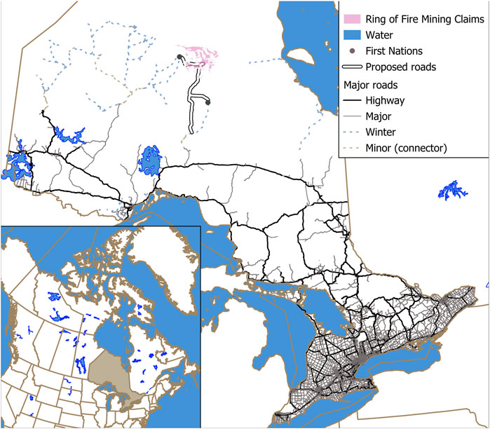
Figure 1. Ring of Fire mining claims in far north Ontario, and proposed and established roads. Inset, a map of Canada, with the province of Ontario highlighted.
As mining companies became aware of it, in 2007, they regarded the RoF as the largest mineral deposit of its kind ever discovered in Canada, with substantial mining opportunities and operations that could last for centuries (Gamble, 2022). However, due to a lack of road infrastructure connecting the region to the rest of Ontario, the RoF is not easily accessible, and extraction is unviable economically without road access (Riley, 2011). With the prospects of mining development drawing increased attention, proposed road networks would connect RoF communities to the south and facilitate resource extraction opportunities (Office of the Premier, 2020). These roads could lead to transformation of a remote, vast, pristine northern Canadian wilderness into a developed and accessible region, providing economic opportunities but also resulting in a more fragmented and environmentally disturbed landscape.
Along with essential main access roads and in addition to the footprint of the mines themselves, mining development in the RoF region will, similar to other regions, result in the construction of a network of varied linear features, including local access and transportation roads, airstrips, transmission lines, as well as other operational infrastructure such as administrative buildings, processing facilities, storage areas, camps, gas stations, and potentially other essential service infrastructure, such as stores and restaurants (Worlanyo and Jiangfeng, 2021). This mining development would likely necessitate complete peatland drainage in some areas; in other areas it would contribute to changing water table levels and flow patterns, caused by the removal and disruption of vegetation and soil, potentially converting them into ecosystem types that are inhospitable for peatland flora and fauna (WSP, 2019) as observed at the DeBeers Canada Victor diamond mine in the James Bay Lowlands region of northern Ontario (Whittington and Price, 2012; Harris et al., 2020). Together, these industrial landscape alterations pose significant and potentially irreversible threats to the ecological integrity and hydrological functioning of peatland ecosystems in the RoF region.
Amid controversies between the federal and provincial governments, mining and exploration companies, and local Indigenous communities (Casey, 2023), exploratory activities and industrial development planning in the RoF region are ongoing, covering approximately 4,972 km2 (Government of Ontario, 2025). Over the years, numerous companies held claims in the RoF region, notably American-based Cleveland-Cliffs (formerly known as Cliffs Natural Resources), which sold its assets in 2015 to Canadian-based Noront Resources Ltd. (Noront), MacDonald Mines Exploration Ltd. (MacDonald) which sold its assets to Noront in 2016, and most recently, Australian-based mining company Wyloo Metals (Wyloo), which bought Noront’s assets in April 2022 (Northern Ontario Business, 2023).
Although the extraction of mineral reserves within the RoF region could bring substantial economic benefits to local communities, the potential development of the region has been politically controversial over the years, facing opposition from several Indigenous communities due to the likely environmental destruction of the fragile boreal ecosystems (Turner, 2022). Industrial development in the RoF region is expected to provide as many as 5,500 jobs annually and generate steady income for several isolated First Nations (FN), particularly the Marten Falls FN, Webequie FN, and Neskantaga FN, scattered throughout the HBL region (Hjartarson et al., 2014; Gamble, 2022) (Figure 2 – Map of Indigenous communities around RoF) (Knight Piésold Consulting, 2013). Initially, it was projected that during the first 32 years of operation, the RoF would contribute up to $16.7 billion to the Gross Domestic Product (GDP) for the mining industry in Ontario, $6.7 billion in government tax revenue, and a total of $5 billion in other sectors (Hjartarson et al., 2014). Given these projected returns, in 2017, the Ontario government allocated a budget of $1 billion to invest in infrastructure to support the region’s development (Office of the Premier, 2017), although as of 2022, the estimated investment needed had increased to over $2 billion (McIntosh, 2022). However, these economic gains would come at a significant environmental cost. The construction of linear infrastructure, such as roads, alongside other developments, including electrical facilities, mining operation plants, and processing facilities will affect the boreal ecosystems of the RoF region and beyond, including the peatlands of the HBL.
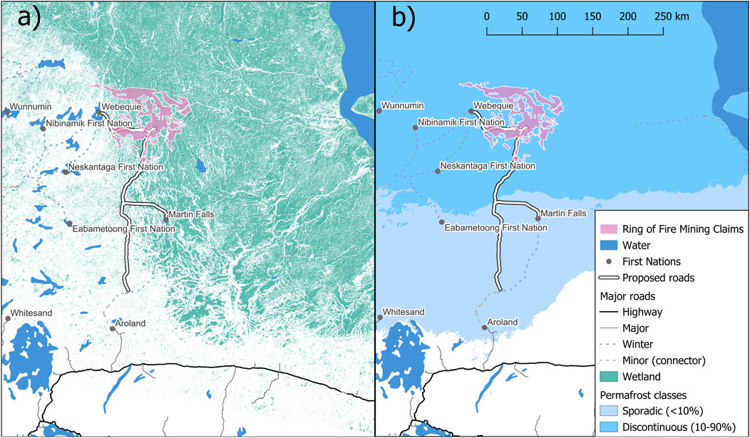
Figure 2. (a) Landscape classification (permafrost classes, wetlands (including peatlands), lakes) and (b) the proposed and established roads in the RoF region, connecting First Nation communities, including Aroland, Marten Falls, Neskantaga, Nibinamik and Webequie with the RoF crescent (where the mining development is currently planned) and the south of the Ontario province.
In October 2019, the RoF region FNs made their first recommendation to the Minister of the Environment and Climate Change Canada (ECCC) within the Canadian federal government, requesting authorization for the Impact Assessment Agency of Canada (IAAC) to conduct a Regional Assessment (RA) for the HBL area (Regional Assessment Working Group, 2025). As a planning tool, the RA will focus on key environmental, social, health, cultural, and economic components that could potentially be affected, whether positively or negatively, by the proposed mining developments and activities in the RoF region. In January 2025, fifteen FN communities in the RoF region, including the Matawa FN, Mushkegowuk FN, and Weenusk FN, together with the ECCC department, established a Terms of Reference aimed at providing clarification and a collective understanding of the purpose of the RA in the RoF region. Our review, in line with the call for an RA, focuses the potential impacts of linear infrastructure on peatlands in the RoF region. As part of the potential effects of the mining development on environmental conditions, the review aims to inform the development of the RA in the Ring of Fire, currently planned as per the Terms of Reference (Regional Assessment Working Group, 2025). Although the Terms of Reference is considered a milestone with respect to planning of the industrial development in the RoF region, the challenges and controversy continue, with few FNs in the area being consulted on the project or in agreement with it (Taschner, 2024; Needham, 2025).
2 Description of the study region proposed for mining development
2.1 Peatlands of Hudson Bay Lowlands
The RoF region (86.3°W, 53.0°N) is located in the James Bay Ecoregion of the Hudson Bay Lowlands Ecozone (Crins et al., 2009; Riley, 2011) (Figure 1). The climate is classified as Perhumid High Boreal, characterized by long, cold winters and short, cool summers (Crins et al., 2009). Average annual precipitation ranges from 528 mm to 833 mm, while the average annual temperature falls between −2.6 °C and −0.5 °C (Crins et al., 2009). This moist, cool climate is essential for peatland persistence in the region (Riley, 2011).
The geology of the region is comprised of limestone, shale, and sandstone (Riley, 2011; Riley, 2003). Over the past 1,000 years, the region has undergone post-glacial rebound, gradually retreating and revealing the lowlands present today (Riley, 2011). As the coasts receded, the land changed from tidal zones to mineral wetlands with marine silts and clay capable of retaining water, which ultimately evolved into the peatlands seen today, covering 90% of the HBL landscape (Riley, 2011) (Figure 2a). Less common mineral terrains include silty till, glacial lake clay, and glaciofluvial deposits (kames and eskers) composed of sorted granular material, along with various mineral soil textures found in alluvial floodplains (Cosford et al., 2019). Along the northern Hudson Bay coastline, extending about 100 km inland, permafrost becomes increasingly discontinuous southward, transitioning into seasonal frost (Riley, 2011; Gruber, 2012) (Figure 2b). In the southern sections of the lowland, permafrost may be restricted to areas of deep peat (Riley, 2003).
This review specifically examines the potential ecological impacts of the prospective linear footprint on peatlands, which cover most of the area targeted by the mining development in the RoF mining claims, as well as to the south of it, where major road construction is planned (Figures 1, 2). The northern portion of this proposed road network in particular falls in the region heavily dominated by wetlands, including peatlands. Peatlands are identified as ecosystems characterized by a thick layer (at least 30–40 cm) of organic matter or peat, resting atop underlying substrates (Rochefort et al., 2012). Vegetative debris accumulates over thousands of years, often forming multi-metre thick organic layers over the mineral soils (McLaughlin and Webster, 2014). The peatlands found in the HBL Ecozone include drier peat plateaus and palsas, often with extensive lichen cover, as well as wetter nutrient-poor (ombrotrophic) bogs and nutrient-rich (minerotrophic) fens (Riley, 2011). More specifically, bogs found in the HBL include domed bogs, northern plateau bogs, net bogs, treed bogs, and thermokarst bogs, while the fens include string fens, ladder fens, channel fens, watertrack fens, and horizontal fens (Cosford et al., 2019).
Peatlands are efficient permafrost insulators and play a key role in determining the vegetative structure of the landscape (Riley, 2011). They are also vital in preventing floods and droughts, providing habitat for diverse and unique species of fauna and flora (Minayeva et al., 2017; Stralberg et al., 2020), filtering drinking water, and supplying resources for human use and consumption (fibers, food, fuel, medicinal plants), as well as holding cultural significance for Indigenous communities (Townsend et al., 2020). Furthermore, peatlands hold pollen traces and artifacts that constitute an important historical record that enhance our understanding of the ecology and climate, as well as the human past (Riley, 2011; Vitt et al., 2011; Rochefort et al., 2012; Minayeva et al., 2017; IUCN, 2021). Moreover, peatlands represent the largest terrestrial store of soil carbon (IUCN, 2021). Globally, peatlands sequester 0.37 gigatons (Gt) of carbon dioxide (CO2) each year (IUCN, 2021) due to slow decomposition under anaerobic, waterlogged conditions (Riley, 2011). Specifically, the HBL stores approximately 74 Gt of carbon as peat within the first 2 m of soil, equivalent to about 13% of the total soil organic carbon and 39% of the amount specifically in peatlands in Canada (Sothe et al., 2022). Consequently, peatlands contribute to climate regulation and can significantly mitigate global climate change (Harris et al., 2022) with the HBL contributing a large portion at the national level.
2.2 Proposed mining developments and companies involved
One of the primary mining projects, originally led by Noront, is the Eagle’s Nest Project, which would involve opening of a multi-metal mine dedicated to extracting nickel, copper, palladium, and platinum through underground mining operations (Knight Piésold Consulting, 2013). The mine would also require the construction of a processing facility and ore transportation and handling infrastructure, as well as permanent disposal areas for waste rock and tailings, all planned to be located underground in the RoF area (Knight Piésold Consulting, 2013). The Eagle’s Nest deposit contains approximately 11 million tonnes of proven and probable reserves, with 9 million more tonnes of inferred resources (Noront Resources, 2021). It would be expected to be in operation for 11–20 years and have an ore production capacity of 2,960 tonnes daily (Knight Piésold Consulting, 2013). After completing the acquisition of Noront in the RoF in April 2022, Wyloo Metals took over the project, committing to developing Eagle’s Nest as a net-zero emission mine (Wyloo, 2022). As of January 2024, Wyloo was still planning Eagle’s Nest Project as the first and most promising site worth development, with the starting date for development foreseen in 2030 (Campbell, 2024).
The other assets, which Noront acquired from Cleveland-Cliffs (2015) and sold to Wyloo (2022) included several chromite deposits: Blackbird Chromite Deposit, Black Thor Deposit, Big Daddy Deposit, and Black Label Deposit (Table 1). Other critical mineral and other deposits in the RoF area include titanium, vanadium and cobalt (prospective Thunderbird mine), copper and zinc (prospective McFaulds and Nikka mines), as well as gold (prospective JJJ mine) and diamond (prospective Kyle and Macfadyen mines). In 2016, Noront also acquired the Butler property (prospective for copper and zinc deposits) and Sanderson property (prospective for nickel, copper and platinum group metals and chromite deposits) from MacDonald, which were also sold by Noront to Wyloo in 2022. If developed, these prospective mines could lead to further construction of open-pit or underground mines, ore processing facilities, tailing ponds, disposal areas, and linear features (access and transportation roads, transmission lines) to support this mining development in the RoF region (with production facilities, including smelters, preliminarily planned for construction elsewhere to the south, in Ontario).
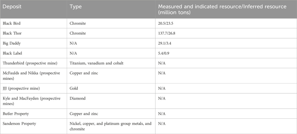
Table 1. Mineral deposits acquired by Wyloo from Noront in 2022.
2.3 Proposed roads in the Ring of Fire region
Before mining development can proceed in the RoF region, road infrastructure must be constructed to access the remote areas of northern Ontario, which are currently disconnected from the major all-season road network in the southern part of the province. The proposed roads would connect Webequie First Nation (WFN) and Martin Falls First Nation (MFFN) to the main road network to the south and provide access to the mining deposits. At present, the only access to MFFN or WFN is via winter road or by air. No winter roads reach the mineral deposits themselves. The exact routes proposed, and construction timelines, have evolved over the last few years with the most recent estimates (i.e., spring 2025) placing the completion of the road network between 2035 and 2040 (Hale, 2025). In 2022, MFFN and WFN took the lead in conducting the provincial and federal Environmental and Impact Assessments for the proposed Marten Falls Community Access Road and Webequie Supply Road projects (Government of Ontario, 2022). While it was announced in May 2023 that it would undergo a federal environmental impact assessment by the IAAC (Cimellaro, 2023), the Ontario government has expressed intent in 2025 to fast-track road construction and resource development in the RoF region despite opposition from the Matawa Chiefs Council (Ross I., 2025).
The Marten Falls Community Access Road would be a 2-lane, 190–230 km long, all-season gravel road that connects the MFFN community to Painter Lake Road on the main road network (Beaney and Barss, 2020) (Figure 2b). The Webequie Supply Road would be approximately 107 km long, extending about 51 km south-southeast toward the WFN community before turning east for about 56 km. This all-season, 2-lane gravel road would lead from the WFN community to the McFaulds Lake area, east of the Mukutei River (Cosford et al., 2019) (Figure 2b). An additional all-season road, the Northern Road Link, would connect the proposed roads, extending from MFFN to the RoF, about 117–164 km in length and crossing the Attawapiskat River (SNC-Lavalin, 2020). This road would become part of a future all-season road network connecting mineral development activities in the RoF region to the provincial highway system at Nakina, Ontario (Northern Road Link, 2023). All these roads would be built within a 100-m right-of-way clearance to a width of 60 m (Northern Ontario Business, 2019). The proposed road network would also facilitate year-round movement between the WFN and MFFN communities and future mine sites in the RoF crescent, enhancing economic opportunities and community engagement in mining development, as well as providing access to other social, health, education or cultural resources, services and opportunities available in the south of the province or elsewhere in Canada. Several additional FNs have concluded agreements with the Ontario government to support road development and infrastructure that would connect their communities to the RoF region through the main road network and provincial highway system (Casey, 2024). For example, in January 2025, Ontario agreed to provide Aroland First Nation with $20 million to support infrastructure projects (Ross, 2025b).
3 Methods of assessment
3.1 Environmental risk assessment of linear disturbance-related mine resource development using the Bowtie Risk Assessment Tool (BRAT)
Risk analysis is essential for understanding and managing cumulative effects related to various environmental problems. These cumulative effects on the environment arise from diverse and overlapping human and natural sources, such as resource extraction, natural disturbance regimes, and climate change, which can compromise peatland services in the HBL region. For various industries and their activities, risk analysis aids policymakers, regulators, and diverse stakeholders in setting aside technical and policy biases. It allows for the language of risk analysis to be spoken using various methods, including the Bowtie Risk Assessment Tool (BRAT). The BRAT approach is recognized by the International Organization for Standardization (IEC/ISO 31010:2009 standard), deriving its name from the shape of the key framework diagram, which resembles a bowtie (CGE Risk Management Solutions, 2017). Recently, BRAT has been utilized to visually synthesize the key elements of environmental risk assessment (Table 2; Winder et al., 2021; Antwi et al., 2023). This technique includes a diagram that lists threats along with corresponding preventative measures, and consequences with corresponding mitigating factors, which may evolve due to a specific hazard, i.e., a key policy developed to achieve the desired outcome (Winder et al., 2021). The application of BRAT for identifying and managing environmental risk events is relatively new but has proven to be an effective and efficient approach (ICES, 2014; Creed et al., 2016; Elliott et al., 2017; Kishchuk et al., 2018; Winder et al., 2021).
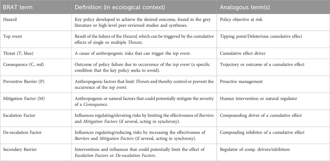
Table 2. The terminology used in the Bowtie Risk Assessment Tool (BRAT) with definitions and analogous terms, simplified and excerpted from Winder et al. (2021). Letters and colour codes in parentheses are used later in the results.
Here we present an application of BRAT to provide a high-level assessment of the potential ecological impacts of planned linear infrastructure and disturbances associated with road construction, as required for the development of proposed mining operations in the RoF region on peatlands in Northern Ontario’s HBL region. While subsequent mining operations themselves can significantly impact the environment (e.g., generating contaminants that may pollute the peatlands surrounding the mines), these effects are beyond the scope of this paper, which focuses on the physical destruction and linear footprint effects on ecological processes and the health of boreal peatlands. Impact assessment of the potential industrial development on socioeconomic, health, and cultural aspects of Indigenous communities in Northern Ontario, though immensely significant and intricately connected to the environmental impacts, is also beyond the scope of this review, which solely focuses on ecological impacts. Nonetheless, the analysis presented here can provide baseline information and science-based knowledge needed to infer potential impacts on the overall wellbeing of the affected FN communities in the RoF region. Separate risk analyses using BRAT or other methods could be applied to the long-term ecological concerns as well as socioeconomic impacts of the mining development in the RoF region. Furthermore, even though the evaluation of potential environmental impacts focuses on peatland ecosystems, which are the dominant ecosystems found in the HBL, many of the identified impacts apply to upland terrestrial ecosystems as well.
As with any industrial operations, for the mining development in the RoF region, multiple factors must be assessed to determine the optimal approach (logistically, economically, socially), while simultaneously minimizing the negative environmental factors. The BRAT approach can inform the development of RA, serving as an effective bridge between science and policy, as it can be utilized by policy analysts to assess potential ecological impacts and the mitigation strategies involved in developing the RoF region. The proposed development in the RoF is presented as a case study to illustrate the utility and effectiveness of BRAT for planning industrial development in the fragile and remote boreal ecosystems in northern Ontario, which, until now, have not experienced an extensive human footprint. Many aspects of the high-level examples of potential threats and their prevention and mitigation of consequences presented here can be applied to other industrial developments in the circumboreal regions of the globe, where northern peatlands are abundant. Furthermore, in the future, BRAT analysis can be used in an iterative fashion to shape and improve and refine operational adaptive management of risks (e.g., Antwi et al., 2023).
3.2 Review of literature to inform qualitative BRAT analysis
As a first step, we performed a literature review of published research on various risk assessment processes and the known impacts of mining and industrial exploratory operations on peatlands in northern regions, primarily in northern Alberta, Canada. Data and information from these sources were extracted to establish a baseline for the assessment (Supplementary Table S1) The research process drew support from previous study results and the expertise of co-authors, collaborators, and other subject matter experts to inform the current study. Results from these studies contributed to identifying impacts, their related consequences, and the various preventive and mitigation strategies that can stop or control the identified impacts. The BRAT framework is used here as a first line consensus building tool to identify, organize and connect potential theatres and their predicted consequences. A brainstorming session in November 2020 and January 2021 with relevant experts was conducted to solicit information on the best possible ways to use the BRAT in the study. Additionally, this session was used to evaluate and validate the identified risks.
In summary, this review is a synthesis of multiple sources used to guide framework development instead of a pre-existing top-level policy document. As such, we do not include quantification of risks. Rather, it is a qualitative process of consulting literature and experts that formed this consensus BRAT framework. However, we quantify potential peatland destruction due to construction of linear infrastructure necessary for the RoF mining development, to show the significance of the identified hazard in our BRAT diagram.
3.3 Quantitative assessment of BRAT top event
As of 2025, the area covered by mining claims in the RoF region was estimated at 8,500 km2 (Canadian Mining Journal Staff, 2025). Considering that peatlands cover ∼90% of the HBL region, we can estimate that ∼7,650 km2 of peatlands could be disturbed by direct mining activities. In addition, supporting linear infrastructure such as the major proposed roads linking the RoF region with the south of the province of Ontario would further add to the area of peatlands affected by mining development. Jointly, the total length of these major proposed roads would be an estimated ∼500 km in length, with an average road width of 60 m, constructed in a 100 m right-of-way clearance, which would presumably include the drainage ditches. Verkaik et al. (2025) state that the area directly influenced by the ditches is ∼30 m, which, with the ditch on each side of the road, would add 60 m of area directly influenced by the road presence. The resulting total width of the linear disturbance would be 160 m. With 500 km in length and 160 m in width, the total area directly impacted by the major roads would be ∼80 km2. As 90% the region is covered by peatlands, we can roughly estimate that ∼72 km2 of these peatlands would be directly affected due to major road network construction. Overall, an estimated 7,722 km2 of peatlands in the RoF region and the area south of it where the roads are to be constructed could be destructed or otherwise affected by the RoF mining development.
4 Results
4.1 Environmental risk analysis outcome
Using the BRAT analysis, the study identified two main threats, and six distinct corresponding consequences related to the potential direct disturbance of 7,722 km2 of Hudson Bay Lowland peatlands due to mining activity and supporting linear infrastructure in the RoF region, along with recommended preventive and mitigation strategies. The first threat (T1) was identified as: drainage and conversion of peatlands for infrastructure development and mining activity. This would lead to habitat fragmentation, including a direct loss of habitat for endangered species and loss of biodiversity [first consequence (C1.1)]; and, increased wildfire risk, resulting in increased greenhouse gas (GHG) emissions and loss of carbon sinks [second consequence (C1.2)]. Furthermore, the BRAT analysis identified the second threat (T2) as: linear infrastructure to support mine development and activity. The resulting consequences of T2 included: edge effects due to habitat fragmentation [third consequence (C2.1)]; the introduction and spread of exotic/invasive species into peatlands, leading to a decline in native biodiversity [fourth consequence (C2.2)]; hydrological shifts (e.g., flooding, drought) causing tree die back, changes in vegetation composition, altered successional pathways, and increased methane emissions [fifth consequence (C2.3)]; and, permafrost degradation resulting in vegetation composition changes and tree die back [sixth consequence (C2.4)]. It is important to note that the drainage and conversion of peatlands (T1) are generally considered as prerequisites for constructing linear (and other) infrastructure (T2). However, here we treat them as two separate threats, based on their individual impacts and consequences on peatlands. The threats, consequences, prevention measures, and mitigation strategies are visually summarized in Figure 3, using a BRAT diagram.
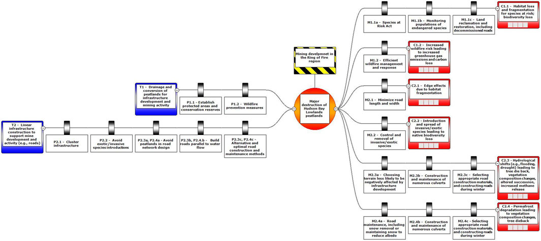
Figure 3. The Bowtie Risk Assessment Tool diagram summarizing the identified threats associated with the linear infrastructure development in the Ring of Fire region (Northern Ontario, Canda), as well as their potential consequences and corresponding preventative measures and mitigating factors.
To prevent the impending threats, our analyses suggested the following preventative measures, identified as P1 for the first threat and P2 for the second threat. For T1 and its consequences: establishing protected areas and conservation reserves (P1.1); and implementing and enforcing wildfire prevention and management measures (P.1.2), corresponding respectively to C1.1., and C1.2. For T2 and its consequences: clustering infrastructure together (P2.1); avoiding exotic species introductions (P2.2); avoiding peatlands in road network design (P2.3a, P2.4a); building roads parallel to water flow (P2.3b, P2.4); and, opting for alternative and optimal road construction and maintenance methods (P2.3c, P2.4c), corresponding respectively to C2.1., C2.2, C2.3, and C2.4. Note that certain consequences had more than one preventative measure identified, designated here by letters a-c, and some preventative measures corresponded to more than one consequence (Figure 3).
The BRAT analysis proposes a combination of legislative and practical resource management actions to mitigate the consequences of the threats when total prevention is unfeasible. Corresponding respectively to T1 and its consequences, these included: enforcement of the Species at Risk Act (M1.1a); monitoring populations of endangered species (M1.1b); land reclamation and restoration, including that of decommissioned roads (M1.1c); efficient wildfire management and response (M1.2). Corresponding respectively to T2 and its consequences, these included: minimizing road length and width (M2.1); control and removal of invasive and exotic species (M2.2); choosing terrain less likely to be negatively affected by infrastructure development (M2.3a); road maintenance, including snow removal or maintaining snow to reduce albedo (M2.4a); construction and maintenance of numerous culverts (M2.3b, M2.4b); and selecting appropriate road construction materials, including recycled materials that are considered byproducts or a waste from other industrial activities, and constructing roads during winter (M2.3c, M2.4c). Similarly to preventative measures, some consequences had more than one mitigating measure identified, designated by letters a-c, and some mitigating measures corresponded to more than one consequence (Figure 3).
It should be recognized here that various factors can facilitate or constrain the implementation of preventive and mitigation strategies. For instance, the recommendation to construct roads that float on peatland and to use of synthetic materials such as geogrid may be limited by the higher construction costs compared to conventional road construction methods. The process of land reclamation and restoration, including restoring decommissioned roads, is at once expensive, labour-intensive, and time-consuming. It also often requires passage of time to evaluate its effectiveness or success (e.g., recovery of tree canopy in a treed peatland). Furthermore, efforts to control invasive and exotic species, whether through chemical or mechanical means, may inadvertently have deleterious effects on some native species. The construction of numerous culverts can lead to debris blockage and increased beaver activity. The recommendation to source construction materials from potentially geographically distant locations to preserve local environment is likely to be logistically inefficient and expensive to implement. Conversely, one enabling factor identified for managing wildfire and responding to crises is training local community members with the necessary skills for identifying threats and implementing required actions, which requires both, interest, engagement and reciprocal collaboration of local communities with the developer. Regardless of the identified constraints, it is crucial that the sustainability of the peatland remains the highest priority in the resource extraction process.
5 Discussion
5.1 Potential impacts of peatland drainage and conversion for mining infrastructure development in the Ring of Fire region
In infrastructure construction that takes place in lowlands such as peatlands, land conversion often occurs before the initiation of the construction, directly affecting the peatland ecosystem and its surrounding environment. Here, we discuss two main consequences of such land conversion i.e., peatland drainage (with associated changes to local hydrology) resulting in habitat fragmentation and destruction (C1.1); and an increased risk of wildfires (C1.2). Habitat fragmentation and destruction results directly in habitat loss for numerous boreal species dependent on peatlands, including certain species at risk, such as federally listed threatened boreal woodland caribou (Rangifer tarandus caribou). Increased risk of wildfires may contribute to permafrost degradation, greater greenhouse gas emissions and even conversion of peatland from carbon sink to carbon source due to loss of carbon stores. These two consequences would directly impact the sustainability of peatlands and the native biodiversity of the RoF region.
The RoF is primarily located in the Missasa caribou range, with a short segment of the road extending into the Nipigon and Pagwachun caribou ranges (Dyson et al., 2022). The Missasa range would be particularly impacted by road construction since it has only been exposed to relatively low levels of anthropogenic presence (e.g., small communities, exploration camps, local winter roads, and the no longer active Victor Diamond Mine as probably the largest disturbance that the region has experienced) (Dyson et al., 2022). Constructing mine infrastructure will necessitate draining and essentially removing peatlands for each proposed mine that is within what is currently a peatland, cumulating the total land conversion and habitat loss (C1.1). While much of it may remain unexploited, the total area covered by mining claims, as of now, is approximately 8,500 km2, representing a 67% increase in mining claim area since 2022 (Canadian Mining Journal Staff, 2025) (Figure 2), even as a single mine may only cover 1 km2 (WSP, 2019). This represents direct habitat loss and habitat fragmentation for numerous species, including species at risk, such as woodland caribou, particularly within the Mississa range (Thomas and Gray, 2002).
Linear infrastructure in boreal ecosystems is known to contribute to functional habitat loss for woodland caribou by altering predator-prey dynamics. Specifically, predators such as wolves (Canis lupus) and black bears (Ursus americanus), which have been observed to have improved mobility and efficiency when travelling on linear features (e.g., seismic lines, pipelines, roads, etc.), will select them as movement corridors between uplands and peatlands (DeMars and Boutin, 2018; Dickie et al., 2020). This increases the risk of incidental predation of caribou in peatlands that would otherwise serve as prey refugia (Tigner et al., 2014; Dickie et al., 2017; DeMars and Boutin, 2018). Dyer et al. (2001) estimated that woodland caribou will avoid up to 22%–48% of their habitat in the presence of linear and other industrial infrastructure, indicating that the area of habitat functionally lost far exceeds the physical footprint of the actual industrial disturbances. Overall, this results in the displacement and concentration of woodland caribou into less preferred habitat (Dyer et al., 2001; Latham et al., 2011). Avoidance behaviour becomes less effective in peatlands with a high density of linear infrastructure, further increasing the risk of encountering predators (McKenzie et al., 2012; DeMars and Boutin, 2018). Additionally, permanent roads surrounded by peatland complexes form a physical barrier or obstacle to caribou movement (also potentially increasing chances of mortality by motor vehicle collisions) and increase unfavourable upland habitat along their edges, further contributing to habitat loss and fragmentation (Dyer et al., 2002).
Establishing protected areas in the RoF region is an effective strategy for preserving peatlands and directly preventing habitat loss and fragmentation for species at risk (Carlson et al., 2015) (P1.1). Furthermore, provisions in the Species at Risk Act (Government of Canada, 2002) (M1.1a), such as those that protect critical habitat for woodland caribou and enforce monitoring of populations (Thomas and Gray, 2002) (M1.1), would mitigate the impacts of habitat loss, even though enforcement has faced some criticism (Nagy-Reis et al., 2021; Turcotte et al., 2021). Nagy-Reis et al. (2021) found that woodland caribou habitat is being lost faster than natural or facilitated regeneration can occur, despite legislative protections like the Species at Risk Act (M1.1a) being in place. This highlights the need to enforce existing protections (M1.1a) and prioritize habitat conservation (P1.1) over restoration programs (M1.1c) in woodland caribou ranges to successfully achieve federal recovery objectives. Additionally, due to the selection of linear infrastructure by predators and their ability to detect prey, linear disturbances in peatland complexes within the caribou range must remain minimal to provide suitable refugia from predation (DeMars and Boutin, 2018). Therefore, establishing adequate protected areas for conservation (P1.1) in woodland caribou range in the HBL is a key to preventing fragmentation and habitat loss.
When options for adequate establishment of protected areas are limited or unfeasible, minimizing the size of disturbance can promote post-disturbance natural regeneration (M2.1). For example, in boreal peatlands, Filicetti et al. (2023) observed faster tree recovery on narrow low impact seismic lines (∼3 m wide compared to conventional seismic lines that are ∼8 m wide), while Dabros and amd Higgins (2023) observed almost 100% return of bryophytes over 8 years since construction of low impact seismic lines in boreal uplands. The capacity for natural regeneration needs to be assessed upon decommission of the site. If needed, active restoration (including recovery of tree canopy) could be implemented (M1.1c). Campbell and Bergeron (2012), who compared natural recovery on winter roads of various times since abandonment in Hudson Bay Lowlands, observed that although the cover of lichens, bryophytes, and vascular plants returned within 5 years to similar levels as in undisturbed peatlands, species richness remained lower and species composition was different than in the undisturbed adjacent peatlands. Recovery of black spruce (Picea mariana) was also limited. Conversely, Filicetti et al. (2019), who monitored the effectiveness of the restoration practices that involved mounding, ripping and tree planting on seismic lines in peatlands of Alberta, reported that after ∼3.5 years treated sites consistently had a higher tree seedling density and appeared to be on the right trajectory towards recovery.
Consideration has also been given to passive (as opposed to active) restoration of peatlands, potentially by wildfire, as it has been theorized that stand-replacing wildfire could erase the impacts of human disturbances (Pinzon et al., 2021). However, wildfire does not seem to restore or mitigate the industrial footprint in peatlands where legacy effects are evident, with linear disturbances involving tree removal such as seismic lines persisting due to altered environmental and structural conditions both before and after the fire (Riva et al., 2020; Barber et al., 2021; Pinzon et al., 2021). For example, Pinzon et al. (2021) found that seismic lines in boreal fens were much wetter than the surrounding treed fens, and, consequently, the lines did not burn while the adjacent treed fens did. Furthermore, with current fire return interval for the HBL region estimated to be between 400 and 900 years (Davies et al., 2023), reliance on wildfire as a passive restoration tool would be inefficient and impractical from the management perspective.
Nevertheless, drainage and desiccation of peatlands caused by the construction of mining infrastructure, including linear projects, may render the disrupted peatlands more vulnerable to wildfires, which can burn with greater severity, frequency, and for extended periods (Turetsky et al., 2011; Granath et al., 2016; Wilkinson et al., 2018) (C1.2). That in turn, can lead to changes in species communities, and significant losses in carbon stock (Kettridge et al., 2015). Harris et al. (2022) stated that ∼2,127 km2 peatland area covered by mining claims in the RoF region would lead to an estimated loss of ∼130 and 250 Mt peat carbon. Following these estimates, we could predict that 7,722 km2 of peatland destruction estimated by us in the RoF region could result in up to ∼470–908 Mt of peat carbon potentially impacted due to mining activity and construction of supporting linear infrastructure. Depending on the type of mining activity (exploration, excavation, infrastructure construction, waste disposal) and the construction methods, some of that peat carbon could be irreversibly lost from this area. Drainage and potential increase in wildfires could exacerbate these loses. For example, Turetsky et al. (2011) noted that carbon released by fires in drained fens was nine times greater than that from fires in pristine peatlands, as ground fuels burned at greater depths. Additionally, drainage increases the availability of ground fuels, as dry, exposed Sphagnum hummocks are more flammable and likely to spread and sustain wildfires compared to saturated Sphagnum expanses (Sherwood et al., 2013). Drainage, both individually and cumulatively with wildfire, can trigger shrubification, leading to a transition from Sphagnum-dominated peatlands to drier shrub-grass ecosystems susceptible to frequent wildfires and peat smoldering, consequently resulting in substantial carbon store losses (Kettridge et al., 2015).
Linear infrastructure has the potential to influence wildfire risk in peatlands by creating unique conditions that alter wildfire behaviour, including changes to fuel composition and environmental and structural conditions that may promote wildfire spread. For example, Weiland et al. (2023) found that linear disturbances create a distinct set of environmental conditions that interact with one another and can enhance wildfire potential, such as increased wind speed and direction, and increased soil and air temperatures. Beyond the impacts of changing fire regimes, the interaction between wildfire and linear infrastructure has compounding effects in peatlands, affecting post-fire recovery and altering species assemblages, and ecosystem resilience and functions, including carbon sink capacity and greenhouse gas emissions (Deane et al., 2020; Filicetti and Nielsen, 2020; Riva et al., 2020; Barber et al., 2021; Enayetullah et al., 2023).
Given the predicted changes to the fire regime and plans for extensive industrial development, it is possible that carbon losses from drained peatlands in RoF would exceed carbon intake in the future, and these peatlands would become a source of greenhouse gases (Turetsky et al., 2011; Wilkinson et al., 2020). Industrial development would also inevitably lead to increased human presence and activity, heightening the risk and potential for human-caused fires (Balch et al., 2017; Sjöström and Gramdström, 2023). Overall, the increase in carbon release during wildfires in drained peatlands is exacerbated by predicted increases in fire severity and frequency due to more persistent drought events resulting from the global climate change crisis (Bergeron et al., 2004; Turetsky et al., 2011; Flannigan et al., 2013).
Measures should be implemented to prevent fire ignitions, such as restricting the operation of equipment based on fire risk assessed by tools like the daily national preparedness level (NPL) from the Canadian Interagency Forest Fire Centre (CIFFC) when the wildfire risk is elevated (P1.2) (Tymstra et al., 2020), given that approximately half of wildfires in Canada are human-caused (Natural Resources Canada, 2023) and more ignitions occur near roads and populated areas (Gralewicz et al., 2012; Sjöström and Gramdström, 2023). Furthermore, building capacity for a rapid initial fire response is often regarded as essential for reducing wildfire severity (Tymstra et al., 2020) (M1.2). Modelling by Granath et al. (2016) has demonstrated that rewetting drained peatlands and restoring the Sphagnum moss layer effectively mitigates the increased fire risk associated with peatland drainage for mining extraction (M1.2). Finally, the measures of establishing protected areas would not only preserve and maintain the habitat of native species, but without direct and intentional land conversion involving peatland drainage, they might also inhibit creation of conditions that are prone to wildfires in the first place.
5.2 Potential impacts of linear infrastructure construction for mine development on peatlands in the Ring of Fire region
The impacts of linear transportation infrastructure (e.g., roads) and other linear feature (e.g., transmission lines) construction in the RoF region (T2) are expected to be particularly significant given that they will occur in a largely intact and pristine landscape. While the proposed roads in northern Ontario would only add approximately 500 km to the existing 217,000 km of roads across the boreal forest in Canada (Pasher et al., 2013), their ecological impacts could be of substantial magnitude in a region that is largely roadless and dominated by peatlands (Poley et al., 2022). Building upon peatlands partially underlain by permafrost would also present engineering challenges. Given the saturated nature of the soil and the weakness of peat as a foundation (Olszewska, 2018), additional materials or tailored construction methods would be necessary (Munro and MacCulloch, 2006), especially as the roads are expected to be frequented by heavy equipment. Road construction would not only be difficult and costly but also damaging to the adjacent peatland ecosystems, introducing edge effects in fragmented habitats (C2.1); spreading invasive and exotic species that threaten native biodiversity (C2.2); altering peatland ecological function by modifying local hydrology and climate mitigation potential, vegetation composition, and successional trajectories (C2.3); and degrading permafrost, which will also influence vegetation communities, wildfire probability, and hydrological regimes (C2.4).
Linear disturbances, such as roads, create edges, which may alter environmental conditions near these disturbance boundaries, leading to edge effects and changes in ecosystem function (C2.1). Depending on the species’ requirements and adaptations, these edge effects may favour certain species while being detrimental to others in peatlands. Watts and Kobziar (2015) studied edge effects in wetland forests dominated by pond cypress (Taxodium distichum var. imbricariumand) and found that temperature and vapour pressure deficits decreased with distance from the edge, while relative humidity increased. Changes like these can diminish the presence of poikilothermic species, ultimately affecting biodiversity. Indeed, numerous studies have shown that edge effects negatively impact multiple amphibian species (deMaynadier and Hunter, 1998; Gibbs, 1998; Mazerolle, 2003), birds (Delage et al., 2000), and some plant species (Poulin et al., 1999; Dabros et al., 2017) in forests and bogs. Conversely, enhanced growth of grasses (e.g., Molinia caerulea) and heather (e.g., Calluna vulgaris) has been observed up to 200 m away from roads due to increased nitrogen inputs from vehicular exhaust, while lichens were less abundant near roads (Angold, 1997). Changes in environmental conditions and plant species composition and abundance due to edge effects can disrupt habitats for other native organisms and lead to overall decreases in native biodiversity (Bender et al., 1998).
Given that constructing linear infrastructure would inevitably lead to habitat fragmentation and edge effects, it is important to optimize infrastructure development by clustering infrastructure as closely as possible to main access routes to reduce the total area at the landscape level affected by edge effects (P2.1) while minimizing the length and width of roads, airstrips, and railways (M2.1). The regulatory approval process for specific infrastructure permits should consider the proximity of proposed mining sites to existing infrastructure, in addition to the size of the specific mine, since a few highly productive sites that are widely distributed can have a greater footprint than several less productive sites clustered together for the same economic output (Jordaan et al., 2009).
Minimizing the total area directly affected by road presence would also reduce the chances and potential for spread of exotic species into natural landscapes through road pathways, which is a common phenomenon, with most research concentrated on vegetation spread and invasion (Mortensen et al., 2009) (C2.2). The invasion of non-native plants often results from vehicles inadvertently transporting non-native seeds into natural areas and from land clearing during road construction (Tyser and Worley, 1992; Parendes and Jones, 2000; Gelbard and Belnap, 2003). Exotic species can be detrimental to ecosystem function as they compete with native species and may disrupt natural succession, as well as contribute to altering nutrient cycles (Sanderson et al., 2012). While peatlands are generally inhospitable to the establishment of exotic species—due, for example, to the acidic, low-nutrient, and waterlogged growing conditions in bogs—some exotic species do manage to establish themselves in disturbed peatlands (Sanderson et al., 2012). For instance, the South American bryophyte Campylopus introflexus has been documented in peatlands across Europe and western North America, outcompeting native bryophytes and lichens (Carter, 2014), while the exotic vascular plant Lythrum salicaria has been recorded with five times higher abundance in disturbed transmission line corridors compared to undisturbed fens (Dubé et al., 2011).
Native invasive non-peatland species can also spread and rapidly invade peatlands when the canopy is removed or when anthropogenic infrastructure modifies the drainage (Dubé et al., 2011). Perennials with traits such as rapid rhizomatous growth and wind-dispersed seeds promote spread and colonization of species in disturbed areas, with corridors such as roads facilitating invasion. Species possessing these traits, such as grass Calamagrostis canadensis found in wetlands across Canada, is known to be highly invasive and problematic in post-disturbance areas, e.g., following harvesting, especially in western boreal ecosystems (Macy and Winder, 2011). While species native to the region may appear less problematic than exotic species, if they have a broad niche, they can become invasive even under suboptimal (for them) conditions, and their impact on ecosystem function and resilience can be just as detrimental (Dubé et al., 2011). Species from the genus Typha (including native T. latifolia, as well as the exotic T. angustifolia and its hybrid T. x glauca) have been found to invade wetlands, including fens, due to their rapid growth rate and adaptability, forming dense mono-specific colonies that negatively impact native wetland flora and fauna (Bansal et al., 2019; Graham et al., 2022; Meeker et al., 2023). Elsewhere, Dubé et al. (2011) found the spread of invasive species into peatlands extended much further into fens than bogs from the edge of the power line disturbance, indicating that fens are more hospitable and therefore more prone to invasives than bogs (Dubé et al., 2011), potentially due to the more acidic and often nutrient-poor conditions found in bogs. As such, fens might be more vulnerable to exotic species invasion and consequential loss of native biodiversity following linear disturbances.
Avoiding unintentional introductions is crucial to prevention of the spread of exotic and invasive species, as eradication is most likely successful before these species become well-established and abundant in their newly invaded ecosystem (Puth and Post, 2005) (P2.2). This can be achieved through measures like requiring wash stations at key road junctions (Bajwa et al., 2018) and implementing targeted surveillance, including the removal of invasive species around gaps created by roads in natural barriers, to reduce spread when populations are still localized (Hulme, 2009; Rejmánek and Pitcairn, 2002) (M2.2).
While exotic and invasive species are examples of biotic factors that can alter plant species composition and successional trajectories of their host ecosystems, alterations of abiotic conditions, including those caused by anthropogenic disturbances such as linear infrastructure construction, are just as likely to affect plant assemblages and ecosystem functioning. Development of roads in the RoF region will inevitably encounter deeper water bodies and wet peatland terrain, necessitating engineered water crossings (SNC-Lavalin, 2020). Similar to beavers, which are known for building dams that flood and drain water systems to suit their needs (Woo and Waddington, 1990), roads function as solid barriers that can obstruct both surface and subsurface water flow across them, thereby altering drainage patterns and water table levels (Chimner et al., 2017; Plach et al., 2017; Saraswati et al., 2020a) (C2.3).
Ecological succession may be hindered (Bocking et al., 2017; Dabros et al., 2022b), and vegetation communities can be altered (Williams-Mounsey et al., 2021) due to changes in water table depth. The water table on the upstream side of roads can rise, resulting in higher soil moisture levels (Chimner et al., 2017; Plach et al., 2017; Elmes et al., 2021) and oversaturated soils that are not conducive to tree growth. For example, tree mortality was observed up to 220 m up-gradient from roads which lowered species richness and reduced canopy cover in peatlands of Alberta (Bocking et al., 2017; Willier, 2017).
Changes in species community composition along linear disturbances may lead to changes in functional diversity (Dabros et al., 2022b; Goud et al., 2024), which can affect ecosystem function (e.g., carbon net balance, Davidson et al., 2021), reduce forage availability and habitat quality for wildlife (Finnegan et al., 2019; Dabros et al., 2022a), influence regeneration and successional trajectories (Dabros et al., 2022b), and lead to overall biodiversity loss (Echiverri et al., 2023). Biodiversity loss resulting from changing species assemblages likely has cascading effects across taxa as native species that are unique to specific peatland habitats are replaced with generalist or non-target species (Echiverri et al., 2023). For example, lichen cover on seismic lines and near their edges in peatlands was significantly reduced to nearly absent compared to nearby undisturbed areas, which may imply a reduction in habitat quality for woodland caribou (Dabros et al., 2022a; Goud et al., 2024).
Broadly speaking, shifts in species composition resulting from changes in environmental conditions caused by development such as road construction will be beneficial to some native species and deleterious to others, overall affecting local biodiversity. Increased competitive advantage of some native species may lead to increase in their dominance, potentially inhibiting other species from regenerating. For example, earlier mentioned C. canadensis is known to aggressively spread in clearings following disturbance and inhibit regeneration of tree species such as Picea glauca (Macey and Winder, 2001), while ericaceous shrubs growing abundantly on seismic lines in bogs are likely inhibiting regeneration of P. mariana (Dabros et al., 2022a).
Furthermore, changes in plant species composition due to linear feature construction and presence can depend on peatland type. For instance, species richness increased on the upstream side of roads in bogs, while it decreased on the upstream side in fens (Willier, 2017). Conversely, a lowered water table on the downstream side of roads may provide more suitable substrates for tree growth, which could lead to the establishment of species that might not otherwise survive, including tree species typically absent from peatlands (Turetsky et al., 2011; Elmes et al., 2021; Willier et al., 2022). The extent of the impact of roads on vegetation communities depends on the substrate underlying the peat, with areas containing low sand content relative to clay exhibiting smaller shifts in vegetation than areas with higher sand content (Willier et al., 2022). Therefore, while a shift in species composition is anticipated after road construction in the peatlands of the RoF region due to changes in drainage and water levels, the degree to which roads affect vegetation communities may depend on the specific peatland type and the substrate.
Just like the spread of invasive species, which is more extensive in fens than bogs, overall shifts in species assemblages along linear infrastructure appear to be more pronounced in fens than bogs (Ficken et al., 2019; Goud et al., 2024), suggesting the importance of discriminant construction of industrial infrastructure across ecosystem types to avoid fragile peatlands. However, it was also observed that resource access road disturbed the surface and subsurface water flow at the bog, but not the fen in boreal forested peatland of Alberta, which was attributed to road orientation that was nearly parallel to the flow direction in the fen, but not in the bog (Saraswati et al., 2020b). This indicates that planning of linear infrastructure development must consider a multitude of interacting biotic and abiotic factors, increasing the complexity of prevention or mitigation of undesired environmental consequences, such as profound changes in plant species composition.
Cumulative effects of human development have regional-scale impacts on lowland plant community composition, even when development is localized or low in proportion to the undeveloped area in the region (Ficken et al., 2019). As vegetation distribution in peatlands is driven largely by the moisture gradient (Graham et al., 2016), altered hydrology resulting from linear infrastructure construction will cause changes to species communities in the HBL peatlands. It is well documented that vegetation (Davidson et al., 2020; Davidson et al., 2021; Dabros et al., 2022a; Dabros et al., 2022b) and arthropod species assemblages (Wu and Pinzon, 2022) that occur and persist over time along linear disturbances such as seismic lines differ from those in the interior undisturbed peatland, including after restoration efforts which have been observed to shift communities even farther from their reference peatland targets, at least in the short term (Echiverri et al., 2023; Goud et al., 2024).
In addition to changes in vegetation communities, methane (CH4) emissions—an important greenhouse gas with a global warming potential approximately 28 times greater than CO2, can also change with fluctuations in the water table and changes in flow patterns (Saraswati and Strack, 2019). Saraswati and Strack (2019) found that methane emissions were up to an order of magnitude higher in areas disturbed by roads compared to reference conditions in a boreal bog in northern Alberta. Similarly, CO2 sequestration has been shown to be lower in a poor fen on the downstream side of roads relative to the upstream side (Plach et al., 2017).
Hydrological connectivity can be maintained despite the construction of linear infrastructure in various ways. While the most straightforward solution is to design the road network to avoid peatlands by routing around them (Munro, 2004; Elmes et al., 2021), the ubiquity of peatlands in the RoF region makes this strategy unfeasible in many sections of the road network (P2.3a). Since complete avoidance of peatlands is unlikely in a region dominated by them, challenges and the associated level of ecosystem disruption can be mitigated by considering terrain type when planning road construction (M2.3a). If mineral soils, which are prevalent in upland conditions and more favourable for road construction, are absent, and a route must be constructed through organic soils (found in peatlands), bogs are preferred over any type of fen, as bogs typically have a deeper water table and fewer open water areas (SNC-Lavalin, 2020). Moreover, treed bogs, likely to possess a thinner organic layer with better drainage and roots anchored in mineral soils, would be more suitable for road construction than open bogs, despite the necessity of removing trees to create a road (SNC-Lavalin, 2020).
When the road surface materials obstruct water flow, building roads parallel to hydrological flow mitigates impacts on vegetation and methane emissions (P2.3b). Roads constructed parallel to the hydraulic gradient did not have a significant effect on the levels of methane emissions from adjacent peatlands, unlike roads built perpendicular to the hydraulic gradient (Saraswati et al., 2020a; Saraswati et al., 2020b). In the RoF region, overall drainage trends from south to north, following the orientation of glaciated landforms and ultimately draining into Hudson Bay (Riley, 2011), and most of the proposed road network generally runs in the S–N orientation.
Installing culverts maintains hydrological connectivity between either side of the road when the roads intersect the hydrological flow (Partington et al., 2016) (M2.3b). Saraswati and Strack (2019) found that methane emissions and hydrological effects were higher 20 m from culverts compared to locations within 2 m of them in boreal peatlands of Alberta. When few culverts are installed, they must be sufficiently wide and regularly monitored and maintained to prevent a buildup of sediment, materials, and beaver structures, thus minimizing flooding hazards and ensuring effective flow across them (Bocking et al., 2017) (M2.3b).
Allowing flow beneath the entire length of the road can be achieved by constructing roads that “float” on top of the peat by layering geosynthetic materials like Geogrid between the road and the peat layers (Forestry Civil Engineering, 2010; SNC-Lavalin, 2020) (P2.3c). The feasibility of this technique depends on several factors, including vehicle traffic (frequency and weight carried) (Forestry Civil Engineering, 2010). If geosynthetic materials are not available, soil stabilization must be implemented. Conventionally used materials in soil stabilization needed for road construction include cement manufactured from crushed limestone, sand and clay, which for logistical reasons are likely to be sourced from the closest location to the construction zone, potentially leading to additional resource extraction and environmental disturbance. However, road construction material could consist of alternative materials such as byproducts from other industrial activities in other regions that otherwise would be considered a waste. Such an approach would not only save local natural resources mitigating additional cumulative disturbance, but it would also allow for recycling and reduction of pollution elsewhere (Vincevica-Gaile et al., 2021) (M2.3c). Examples of such alternative products include ashes from various industrial productions and manufacturing such as agriculture or energy production or even municipal waste, used in place of cement and lime in order to stabilize compressible peatland soils (Vincevica-Gaile et al., 2021). Finally, even timing of the road construction could mitigate the negative impact on peatlands, with winter generally being considered as the optimal time, since the frozen ground reduces damage and compression of peat by heavy machinery (Dabros et al., 2018) (M2.3c).
Even with the preventative and mitigative measures taken to reduce the negative consequences of altered hydrological regimes, the construction of linear infrastructure is likely to cause permafrost degradation. This results from the vegetation removal, soil compaction, and alterations to ground surface properties (Jin et al., 2006; Dabros et al., 2018) (C2.4). The RoF is in a region with an estimated permafrost cover of approximately 20%, extending as far south as 30 km from MFFN along the proposed Northern Link Road (Gruber, 2012). Permafrost is especially susceptible to disturbance at its southern boundary, where elevated soil temperatures reduce its thermal stability (Qingbai et al., 2002), further exacerbated by global warming, making the effects on permafrost crucial to assess.
The construction of roads in the RoF is likely to cause permafrost degradation given the low thermal stability of permafrost at its southern limit, leading to engineering challenges in maintaining road infrastructure, ecological impacts on the surrounding landscape, and globally with the release of carbon as permafrost thaws. The typical mineral material (e.g., sand and gravel) used for road and other infrastructure construction has a lower albedo than peat, increasing radiative heat transfer to the ground and resulting in permafrost thaw (Qingbai et al., 2002; Kondratiev, 2017).
Tree cover and thick bryophyte or lichen mats function to insulate the ground layer, decreasing thaw depths (Camill, 2000; Gornall et al., 2007; Higgins and Garon-Labrecque, 2018), while the removal of the tree canopy was observed to cause permafrost degradation (Williams et al., 2013). Peat insulates the ground beneath it, protecting permafrost from warm temperatures and retaining precipitation at the upper soil surface that would otherwise initiate thawing (Riley, 2011). Permafrost thaw has been observed to be substantially increased along linear disturbances, increasing soil moisture, altering drainage patterns, reducing peatland water storage capacity, and modifying the direction of natural hydrological flow, all of which contribute to the inability of permafrost to regenerate (Quinton et al., 2009; Williams et al., 2013; Braverman and Quinton, 2016). Permafrost thaw alters the physical structure and plant community composition of peatlands, where thawed areas may subside or collapse (thermokarst formation), leading to a land cover transition from treed permafrost peat plateaus to graminoid fens (Emers et al., 1995; Dyke and Sladen, 2010).
Human-induced permafrost thaw can create a positive feedback effect by increasing thaw depth and facilitating movement in the talik layer, which flows year-round and connects permafrost with permafrost-free peatlands, perpetuating further melt (Braverman and Quinton, 2016). Additionally, increased methane emissions (Bubier et al., 1995) and substantial deep peat carbon stock losses occur after permafrost melt in peatlands within the discontinuous zone, contributing to climate warming and reinforcing the positive feedback (Turetsky et al., 2002; Harris et al., 2023). Cumulatively, these climate warming effects and the development of linear infrastructure exacerbate positive feedback and further accelerate permafrost thaw (Turetsky et al., 2002; Quinton et al., 2009; Dyke and Sladen, 2010; Braverman and Quinton, 2016).
Avoiding peatlands and building roads in uplands where possible (P2.4a) would be the first step in preventing and mitigating permafrost disturbance due to linear feature construction. Providing appropriate road maintenance, including maintaining snow cover for a longer time to reduce albedo in the early spring (M2.4a) could also mitigate permafrost thaw through reducing the impact of thermal radiation on the roads (Chen et al., 2020; Williams et al., 2013). Furthermore, constructing roads parallel to hydraulic gradients and water flow (P2.4b), and constructing culverts that are frequently maintained (M2.4b), could further reduce permafrost thaw rates. Other examples of optimizing road construction to avoid soil and permafrost damage (P2.4c) would be to construct it during winter to reduce the initial impact of heavy equipment causing soil compression and reduction of depth to water table and depth of the active layer (M2.4c).
5.3 Conclusion
RoF development is planned for one of the most remote and pristine northern communities in one of the biggest peatland complexes globally. Although the actual mining development may not be large area-wise, the infrastructure needed for its development can have a profound and potentially irreversible impact on peatlands–a sensitive, fragile and unique ecosystem, which provides crucial ecosystem services, particularly in terms of carbon storage and climate regulation. As such, assessment of potential environmental impacts is pertinent to elimination or at least reduction of the negative environmental impacts. Here, we used BRAT methodology to build a risk analysis framework that synthesizes the opinion of consulted expertise to identify potential threats and consequences of the linear feature development in peatlands of RoF region, followed by evaluation of preventative and mitigation measures. This is the first step of analysis, focusing on the ecological impacts of peatland drainage and linear infrastructure construction. A more fulsome set of qualitative and quantitative risk analyses will be required at longer-term, including analyses of socioeconomic top events. These will include information contributed by First Nations and other stakeholders, allowing the formation of a comprehensive picture of the risks and impacts of the planned mining development in the RoF region.
Linear disturbances, including roads and corridors required for transmission lines, will lead to habitat fragmentation and, depending on the construction approach, may result in direct disruption of peatlands, for example through removal of tree cover and drainage, which will lead to changes in plant community composition. While formation of peatlands in the RoF region took thousands of years, impending land changes associated with industrial development can lead to their rapid destruction, affecting various species of flora and fauna, which have adapted and are dependent on it, changing wildfire regimes, and leading to permafrost degradation, all of which will affect carbon emissions that will further contribute to ongoing global climate change.
Total avoidance of industrial development and thus the necessity of linear feature construction is the only approach which would entirely eliminate the intricate nature of cumulative and interacting effects and their feedback; however, in the face of political and economic pressures, eventual development in Far North Ontario is likely impending. Although the focus of this review was on evaluating the potential ecological threats and consequences of the disruption of peatlands and their functions, evaluation of such environmental impacts, as well as socio-economic impacts on Indigenous communities whose members have inhabited these lands for centuries is of utmost importance, as they would be the ones most directly affected by industrial development of the RoF region. Living off the land and its provisions for millennia, First Nations of the RoF region are a prime example that humans and nature can coexist in harmony–a goal that should underline any decisions and planning of large-scale land conversion to access natural resources.
Author contributions
AD: Visualization, Software, Conceptualization, Funding acquisition, Investigation, Writing – original draft, Resources, Writing – review and editing, Methodology, Validation, Formal Analysis, Project administration, Supervision. EA: Supervision, Formal Analysis, Writing – review and editing, Writing – original draft, Investigation, Methodology, Conceptualization, Visualization. CW: Writing – original draft, Investigation, Writing – review and editing. AD: Investigation, Writing – review and editing, Writing – original draft. KLH: Methodology, Investigation, Writing – original draft, Writing – review and editing, Visualization.
Funding
The author(s) declare that financial support was received for the research and/or publication of this article. The Cumulative Effects Program of the Canadian Forest Service- Natural Resources Canada funded this research. The Cumulative Effects Program of Canadian Forest Service-Natural Resources Canada did not play any role in preparing this manuscript.
Acknowledgments
We would like to acknowledge the experts who shared their knowledge with us during the workshops in November 2021; Kristen Schafer for help with literature review; Jeff Sahadeo for editorial work; Richard Winder for guidance and advise with the BRAT analysis; and our managers at Canadian Forest Service, Matthew Wheatley and Katalijn McAfee for their continuing support.
Conflict of interest
The authors declare that the research was conducted in the absence of any commercial or financial relationships that could be construed as a potential conflict of interest.
The reviewer RW declared a past co-authorship with the author AD to the handling editor.
Generative AI statement
The author(s) declare that no Generative AI was used in the creation of this manuscript.
Any alternative text (alt text) provided alongside figures in this article has been generated by Frontiers with the support of artificial intelligence and reasonable efforts have been made to ensure accuracy, including review by the authors wherever possible. If you identify any issues, please contact us.
Publisher’s note
All claims expressed in this article are solely those of the authors and do not necessarily represent those of their affiliated organizations, or those of the publisher, the editors and the reviewers. Any product that may be evaluated in this article, or claim that may be made by its manufacturer, is not guaranteed or endorsed by the publisher.
Supplementary material
The Supplementary Material for this article can be found online at: https://www.frontiersin.org/articles/10.3389/fenvs.2025.1676633/full#supplementary-material
References
Angold, P. G. (1997). The impact of a road upon adjacent heathland vegetation: effects on plant species composition. J. Appl. Ecol. 34, 409–417. doi:10.2307/2404886
Antwi, E. K., Boakye-Danquah, J., Owusu-Banahene, W., Dabros, A., Eddy, I. M., Silver, D. A., et al. (2023). Risk assessment framework for cumulative effects (RAFCE). Front. Environ. Sci. 10, 1055159. doi:10.3389/fenvs.2022.1055159
Bajwa, A. A., Nguyen, T., Navie, S., O’Donnell, C., and Adkins, S. (2018). Weed seed spread and its prevention: the role of roadside wash down. J. Environ. Manage. 208, 8–14. doi:10.1016/j.jenvman.2017.12.010
Balch, J. K., Bradley, B. A., Abatzoglou, J. T., Nagy, R. C., Fusco, E. J., and Mahood, A. L. (2017). Human-started wildfires expand the fire niche across the United States. Proc. Natl. Acad. Sci. U.S.A. 114, 2946–2951. doi:10.1073/pnas.1617394114
Bansal, S., Lishawa, S. C., Newman, S., Tangen, B. A., Wilcox, D., Albert, D., et al. (2019). Typha (cattail) invasion in North American wetlands: biology, regional problems, impacts, ecosystem services, and management. Wetlands 39, 645–684. doi:10.1007/s13157-019-01174-7
Barber, Q. E., Bater, C. W., Dabros, A., Pinzon, J., Nielsen, S. E., and Parisien, M.-A. (2021). Persistent impact of conventional seismic lines on boreal vegetation structure following wildfire. Can. J. Res. 51, 1581–1594. doi:10.1139/cjfr-2020-0455
Beaney, J., and Barss, S. (2020). Marten falls first nation proposed terms of reference: Marten falls community access road - environmental assessment. AECOM Canada Ltd. Available online at: https://www.martenfallsaccessroad.ca/wp-content/uploads/2020/09/FULL_RPT_2020-09-09_Proposed-ToR_60593122_WEB-1.pdf (Accessed February 22, 2025).
Bender, D. J., Contreras, T. A., and Fahrig, L. (1998). Habitat loss and population decline: a meta-analysis of the patch size effect. Ecol 79, 517–533. doi:10.1890/0012-9658(1998)079[0517:HLAPDA]2.0.CO;2
Bergeron, Y., Flannigan, M., Gauthier, S., Leduc, A., and Lefort, P. (2004). Past, current and future fire frequency in the Canadian boreal forest: implications for sustainable forest management. Ambio 33, 356–360. doi:10.1579/0044-7447-33.6.356
Bocking, E., Cooper, D. J., and Price, J. (2017). Using tree ring analysis to determine impacts of a road on a boreal peatland. For. Ecol. Manage. 404, 24–30. doi:10.1016/j.foreco.2017.08.007
Braverman, M., and Quinton, W. L. (2016). Hydrological impacts of seismic lines in the wetland-dominated zone of thawing, discontinuous permafrost, Northwest Territories, Canada. Hydrol. Process. 30, 2617–2627. doi:10.1002/hyp.10695
Bubier, J. L., Moore, T. R., Bellisario, L., Comer, N. T., and Crill, P. M. (1995). Ecological controls on methane emissions from a northern peatland complex in the zone of discontinuous permafrost, Manitoba, Canada. Glob. Biogeochem. Cycles 9, 455–470. doi:10.1029/95GB02379
Camill, P. (2000). How much do local factors matter for predicting transient ecosystem dynamics? Suggestions from permafrost formation in boreal peatlands. Glob. Change Biol. 6, 169–182. doi:10.1046/j.1365-2486.2000.00293.x
Campbell, A. (2024). Door remains open for Indigenous dialogue, says Ring of Fire mine developer. Northern Ontario Business. Available online at: https://www.northernontariobusiness.com/industry-news/mining/ring-of-fire-metals-ceo-provides-updates-about-eagles-nest-project-8154652 (Accessed April 23, 2025).
Campbell, D., and Bergeron, J. (2012). Natural revegetation of winter roads on peatlands in the Hudson Bay Lowland, Canada. Arct. Antarct. Alp. Res. 44, 155–163. doi:10.2307/23252809
Canadian Mining Journal (CMJ) Staff. (2025). Ring of Fire mining claims have skyrocketed: environmentalist. Can. Min. J. Available online at: https://www.canadianminingjournal.com/news/ring-of-fire-mining-claims-have-skyrocketed-urban-environmentalist-group/ (Accessed August 28, 2025).
Carlson, M., Wells, J., and Jacobson, M. (2015). Balancing the relationship between protection and sustainable management in Canada’s boreal forest. Conserv. Soc. 13, 13. doi:10.4103/0972-4923.161209
Carter, B. E. (2014). Ecology and distribution of the introduced moss Campylopus introflexus (Dicranaceae) in western North America. Madroño 61 (1), 82–86. doi:10.3120/0024-9637-61.1.82
Casey, L. (2023). Inside the battle over Ontario’s ring of fire. CBC. Available online at: https://www.cbc.ca/news/canada/toronto/ont-ring-of-fire-1.6991468. (Accessed March 8, 2024).
Casey, L. (2024). 4 First Nations sign deal with Ontario to build roads near Ring of Fire. Financial Post. Available online at: https://www.cbc.ca/news/canada/toronto/ont-ring-of-fire-1.699146 (Accessed April 25, 2025).
CGE Risk Management Solutions (2017). The history of Bowtie. Available online at: https://www.cgerisk.com/knowledgebase/The_history_of_bowtie. (Accessed February 7, 2024).
Chen, L., Fortier, D., McKenzie, J. M., and Sliger, M. (2020). Impact of heat advection on the thermal regime of roads built on permafrost. Hydrol. Process. 34, 1647–1664. doi:10.1002/hyp.13688
Chimner, R. A., Cooper, D. J., Wurster, F. C., and Rochefort, L. (2017). An overview of peatland restoration in North America: where are we after 25 years? Restor. Ecol. 25, 283–292. doi:10.1111/rec.12434
Cimellaro, M. (2023). Road to Ontario’s Ring of Fire will undergo federal environmental assessment. National Observer. Available online at: https://www.nationalobserver.com/2023/05/26/news/road-ontario-ring-fire-undergo-federal-environmental-assessment (Accessed March 17, 2025).
Cosford, J. J., Zimmer, T. A. M., and Penner, L. A. (2019). Webequie supply road: terrain analysis, potential aggregate sources and identification of route alternatives. J.D. Mollard and Associates 2010 Limited. Available online at: https://www.supplyroad.ca/wp-content/uploads/2020/08/SNC-WSR-Supportive-Documentation-for-ToR-JD-Mollard-2019-03-29.pdf (Accessed July 30, 2025).
Creed, I. F., Cormier, R., Laurent, K. L., Accatino, F., Igras, J., Henley, P., et al. (2016). Formal integration of science and management systems needed to achieve thriving and prosperous Great Lakes. BioScience 66, 408–418. doi:10.1093/biosci/biw030
Crins, W. J., Gray, P. A., Uhlig, P. W. C., and Wester, M. C. (2009). The ecosystems of Ontario, Part 1: ecozones and ecoregions. Peterbourough, ON: Ontario Ministry of Natural Resources, Inventory Monitoring and Assessment.
Dabros, A., and amd Higgins, K. L. (2023). Vegetation recovery and edge effects of low impact seismic lines over eight-year period in boreal uplands of northern Alberta. For. Ecol. Manage. 532, 120850. doi:10.1016/j.foreco.2023.120850
Dabros, A., James Hammond, H. E., Pinzon, J., Pinno, B., and Langor, D. (2017). Edge influence of low-impact seismic lines for oil exploration on upland forest vegetation in northern Alberta (Canada). For. Ecol. Manage. 400, 278–288. doi:10.1016/j.foreco.2017.06.030
Dabros, A., Pyper, M., and Castilla, G. (2018). Seismic lines in the boreal and arctic ecosystems of North America: environmental impacts, challenges, and opportunities. Environ. Rev. 26, 214–229. doi:10.1139/er-2017-0080
Dabros, A., Higgins, K. L., and Pinzon, J. (2022a). Seismic line edge effects on plants, lichens and their environmental conditions in boreal peatlands of Northwest Alberta (Canada). Restor. Ecol. 30, e13468. doi:10.1111/rec.13468
Dabros, A., Higgins, K. L., Santala, K., and Aubin, I. (2022b). Plant functional trait approach to assess the persistence of seismic line footprint in boreal peatlands of Alberta, Canada. For. Ecol. Manage. 503, 119751. doi:10.1016/j.foreco.2021.119751
Davidson, S. J., Goud, E. M., Franklin, C., Nielsen, S. E., and Strack, M. (2020). Seismic line disturbance alters soil physical and chemical properties across boreal forest and peatland soils. Front. Earth Sci. 8, 281. doi:10.3389/feart.2020.00281
Davidson, S. J., Goud, E. M., Malhotra, A., Estey, C. O., Korsah, P., and Strack, M. (2021). Linear disturbances shift boreal peatland plant communities toward earlier peak greenness. J. Geophys. Res. Biogeosci. 126, e2021JG006403. doi:10.1029/2021JG006403
Davies, M. A., McLaughlin, J. W., Packalen, M. S., and Finkelstein, S. A. (2023). Using Holocene paleo-fire records to estimate carbon stock vulnerabilities in Hudson Bay Lowlands Peatlands. FACETS 8, 1–26. doi:10.1139/facets-2022-0162
Deane, P. J., Wilkinson, S. L., Moore, P. A., and Waddington, J. M. (2020). Seismic lines in treed boreal peatlands as analogs for wildfire fuel modification treatments. Fire 3, 21. doi:10.3390/fire3020021
Delage, V., Fortin, M.-J., and Desrochers, A. (2000). Effects of peripheral and isolated locations of songbird habitats in mined bogs. Écoscience 7, 149–156. doi:10.1080/11956860.2000.11682583
DeMars, C. A., and Boutin, S. (2018). Nowhere to hide: effects of linear features on predator–prey dynamics in a large mammal system. J. Anim. Ecol. 87, 274–284. doi:10.1111/1365-2656.12760
deMaynadier, P. G., and Hunter, M. L. (1998). Effects of silvicultural edges on the distribution and abundance of amphibians in Maine. Conserv. Biol. 12, 340–352. doi:10.1111/j.1523-1739.1998.96412.x
Dickie, M., Serrouya, R., McNay, R. S., and Boutin, S. (2017). Faster and farther: wolf movement on linear features and implications for hunting behaviour. J. Appl. Ecol. 54, 253–263. doi:10.1111/1365-2664.12732
Dickie, M., McNay, S. R., Sutherland, G. D., Cody, M., and Avgar, T. (2020). Corridors or risk? movement along, and use of, linear features varies predictably among large mammal predator and prey species. J. Anim. Ecol. 89, 623–634. doi:10.1111/1365-2656.13130
Dubé, C., Pellerin, S., and Poulin, M. (2011). Do power line rights-of-way facilitate the spread of non-peatland and invasive plants in bogs and fens? Botany 89, 91–103. doi:10.1139/B10-089
Dyer, S. J., O’Neill, J. P., Wasel, S. M., and Boutin, S. (2001). Avoidance of industrial development by woodland caribou. J. Wildl. Manage. 65, 531–542. doi:10.2307/3803106
Dyer, S. J., O’Neill, J. P., Wasel, S. M., and Boutin, S. (2002). Quantifying barrier effects of roads and seismic lines on movements of female woodland caribou in northeastern Alberta. Can. J. Zool. 80, 839–845. doi:10.1139/z02-060
Dyke, L. D., and Sladen, W. E. (2010). Permafrost and peatland evolution in the northern Hudson Bay lowland, Manitoba. Arctic 63, 429–441. doi:10.14430/arctic3332
Dyson, M., Endicott, S., Simpkins, C., Turner, J. W., Avery-Gomm, S., Johnson, C. A., et al. (2022). Existing caribou habitat and demographic models need improvement for Ring of Fire impact assessment: a roadmap for improving the usefulness, transparency, and availability of models for conservation. bioRxiv. doi:10.1101/2022.06.01.494350
Echiverri, L., Pinzon, J., and Dabros, A. (2023). Inverted soil mounding as a restoration approach of seismic lines in boreal peatlands: implications on plant and arthropod abundance and diversity. Forests 14, 2123. doi:10.3390/f14112123
Elliott, M., Burdon, D., Atkins, J. P., Borja, A., Cormier, R., De Jonge, V. N., et al. (2017). “And DPSIR begat DAPSI(W)R(M)!” - a unifying framework for marine environmental management. Mar. Pollut. Bull. 118, 27–40. doi:10.1016/j.marpolbul.2017.03.049
Elmes, M. C., Kessel, E., Wells, C. M., Sutherland, G., Price, J. S., Macrae, M. L., et al. (2021). Evaluating the hydrological response of a boreal fen following the removal of a temporary access road. J. Hydrol. 594, 125928. doi:10.1016/j.jhydrol.2020.125928
Emers, M., Jorgenson, J. C., and Raynolds, M. K. (1995). Response of arctic tundra plant communities to winter vehicle disturbance. Can. J. Bot. 73, 905–917. doi:10.1139/b95-099
Enayetullah, H., Chasmer, L., Hopkinson, C., Thompson, D., and Cobbaert, D. (2023). Examining drivers of post-fire seismic line ecotone regeneration in a boreal peatland environment. Forests 14 (10), 1979. doi:10.3390/f14101979
Ficken, C. D., Cobbaert, D., and Rooney, R. C. (2019). Low extent but high impact of human land use on wetland flora across the boreal oil sands region. Sci. Total Environ. 693, 133647. doi:10.1016/j.scitotenv.2019.133647
Filicetti, A. T., and Nielsen, S. E. (2020). Tree regeneration on industrial linear disturbances in treed peatlands is hastened by wildfire and delayed by loss of microtopography. Can. J. For. Res. 50, 936–945. doi:10.1139/cjfr-2019-0451
Filicetti, A., Cody, M., and Nielsen, S. (2019). Caribou conservation: restoring trees on seismic lines in Alberta, Canada. Forests 10, 185. doi:10.3390/f10020185
Filicetti, A. T., Tigner, J., Nielsen, S. E., Wolfenden, K., Taylor, M., and Bentham, P. (2023). Low-impact line construction retains and speeds recovery of trees on seismic lines in forested peatlands. Can. J. For. Res. 53 (11), 878–892. doi:10.1139/cjfr-2022-0250
Finnegan, L., Pigeon, K. E., and MacNearney, D. (2019). Predicting patterns of vegetation recovery on seismic lines: informing restoration based on understory species composition and growth. For. Ecol. Manage. 446, 175–192. doi:10.1016/j.foreco.2019.05.026
Flannigan, M., Cantin, A. S., De Groot, W. J., Wotton, M., Newbery, A., and Gowman, L. M. (2013). Global wildland fire season severity in the 21st century. For. Ecol. Manage. 294, 54–61. doi:10.1016/j.foreco.2012.10.022
Forestry Civil Engineering (2010). Floating roads on peat: a report into good practice in design, construction and use of floating roads on peat with particular reference to Wind Farm Developments in Scotland. Prepared by: Forestry Civil Engineering, Scottish Natural Heritage. Forestry Commission Scotland. Available online at: https://www.roadex.org/wp-content/uploads/2014/01/FCE-SNH-Floating-Roads-on-Peat-report.pdf (Accessed March 26, 2025).
Gamble, J. (2022). What’s at stake in Ontario’s ring of fire. Canadian Geographic. Available online at: https://canadiangeographic.ca/articles/whats-at-stake-in-ontarios-ring-of-fire/ (Accessed February 22, 2025).
Gelbard, J. L., and Belnap, J. (2003). Roads as conduits for exotic plant invasions in a semiarid landscape. Conserv. Biol. 17 (2), 420–432. doi:10.1046/j.1523-1739.2003.01408.x
Gibbs, J. P. (1998). Amphibian movements in response to forest edges, roads, and streambeds in southern New England. J. Wildl. Manage. 62, 584. doi:10.2307/3802333
Gornall, J. L., Jónsdóttir, I. S., Woodin, S. J., and Van Der Wal, R. (2007). Arctic mosses govern below-ground environment and ecosystem processes. Oecologia 153, 931–941. doi:10.1007/s00442-007-0785-0
Goud, E. M., Davidson, S. J., Dabros, A., Kleinke, K., Schmidt, M. A., and Strack, M. (2024). Do linear clearings in boreal peatlands recover? comparing taxonomic, phylogenetic, and functional plant diversity. Botany. 102 438–451. doi:10.1139/cjb-2024-0041
Government of Canada (2002). Species at risk Act (S.C. 2002, c. 29). Available online at: https://laws.justice.gc.ca/eng/acts/s-15.3/(Accessed March 3, 2025).
Government of Ontario (2022). Ontario’s critical minerals strategy. Available online at: https://www.ontario.ca/files/2022-03/ndmnrf-ontario-critical-minerals-strategy-2022-2027-en-2022-03-22.pdf. (Accessed October 4, 2024).
Government of Ontario (2025). Ontario’s ring of fire. Ontario. Available online at: https://www.ontario.ca/page/ontarios-ring-fire (Accessed March 17, 2025).
Graham, J. A., Hartsock, J. A., Vitt, D. H., Wieder, R. K., and Gibson, J. J. (2016). Linkages between spatio-temporal patterns of environmental factors and distribution of plant assemblages across a boreal peatland complex. Boreas 45, 207–219. doi:10.1111/bor.12151
Graham, A., Mudrzynski, B., Polzer, E., and Wilcox, D. A. (2022). Restoration of a Lake Ontario-connected fen through invasive Typha removal. Restor. Ecol. 30, e13562. doi:10.1111/rec.13562
Gralewicz, N. J., Nelson, T. A., and Wulder, M. A. (2012). Spatial and temporal patterns of wildfire ignitions in Canada from 1980 to 2006. Int. J. Wildland Fire 21, 230. doi:10.1071/WF10095
Granath, G., Moore, P. A., Lukenbach, M. C., and Waddington, J. M. (2016). Mitigating wildfire carbon loss in managed northern peatlands through restoration. Sci. Rep. 6, 28498. doi:10.1038/srep28498
Gruber, S. (2012). Derivation and analysis of a high-resolution estimate of global permafrost zonation. Cryosphere 6, 221–233. doi:10.5194/tc-6-221-2012
Hale, A. S. (2025). Ring of Fire access roads may not be complete until 2040. Northern Ontario Business. Available online at: https://www.northernontariobusiness.com/regional-news/far-north-ring-of-fire/ring-of-fire-access-roads-may-not-be-complete-until-2040-10312109 (Accessed March 17, 2025).
Harris, L. I., Roulet, N. T., and Moore, T. R. (2020). Drainage reduces the resilience of a boreal peatland. Environ. Res. Commun. 2, 065001. doi:10.1088/2515-7620/ab9895
Harris, L. I., Richardson, K., Bona, K. A., Davidson, S. J., Finkelstein, S. A., Garneau, M., et al. (2022). The essential carbon service provided by northern peatlands. Front. Ecol. Environ. 20, 222–230. doi:10.1002/fee.2437
Harris, L. I., Olefeldt, D., Pelletier, N., Blodau, C., Knorr, K., Talbot, J., et al. (2023). Permafrost thaw causes large carbon loss in boreal peatlands while changes to peat quality are limited. Glob. Change Biol. 29, 5720–5735. doi:10.1111/gcb.16894
Higgins, K. L., and Garon-Labrecque, M. (2018). Fine-scale influences on thaw depth in a forested peat plateau landscape in the Northwest Territories, Canada: vegetation trumps microtopography. Permafr. Periglac. 29, 60–70. doi:10.1002/ppp.1961
Hjartarson, J., McGuinty, L., Boutilier, S., and Majernikova, E. (2014). Beneath the surface: uncovering the economic potential of Ontatio’s ring of fire. Ontario Chamber of Commerce. Available online at: https://occ.ca/wp-content/uploads/Beneath_the_Surface_web-1.pdf.
Hulme, P. E. (2009). Trade, transport and trouble: managing invasive species pathways in an era of globalization. J. Appl. Ecol. 46, 10–18. doi:10.1111/j.1365-2664.2008.01600.x
ICES (2014). Report of the joint Rijkswaterstaat/DFO/ICES workshop: risk assessment for Spatial management (WKRASM). Amsterdam, Netherlands. International Council for the Exploration of the Sea. Available online at: https://ices-library.figshare.com/articles/report/Report_of_the_Joint_Rijkswaterstaat_DFO_ICES_Workshop_Risk_Assessment_for_Spatial_Management_WKRASM_/19257683?file=34214111 (Accessed March 27, 2025).
IUCN (2021). Peatlands and climate change. International Union for Conservation of Nature. Available online at: https://iucn.org/sites/default/files/2022-04/iucn_issues_brief_peatlands_and_climate_change_final_nov21.pdf (Accessed February 22, 2025).
Jin, H., Zhao, L., Wang, S., and Jin, R. (2006). Thermal regimes and degradation modes of permafrost along the Qinghai-Tibet Highway. Sci. China, Ser. D. Earth Sci. 49, 1170–1183. doi:10.1007/s11430-006-2003-z
Jordaan, S. M., Keith, D. W., and Stelfox, B. (2009). Quantifying land use of oil sands production: a life cycle perspective. Environ. Res. Lett. 4, 024004. doi:10.1088/1748-9326/4/2/024004
Kettridge, N., Turetsky, M. R., Sherwood, J. H., Thompson, D. K., Miller, C. A., Benscoter, B. W., et al. (2015). Moderate drop in water table increases peatland vulnerability to post-fire regime shift. Sci. Rep. 5, 8063. doi:10.1038/srep08063
Kishchuk, B. E., Creed, I. F., Laurent, K. L., Nebel, S., Kreutzweiser, D., Venier, L., et al. (2018). Assessing the ecological sustainability of a forest management system using the ISO Bowtie Risk Management Assessment Tool. For. Chron. 94, 25–34. doi:10.5558/tfc2018-005
Knight Piésold Consulting (2013). Noront Eagle’s nest project: a federal/provincial environmental impact statement/environmental assessment report. Available online at: https://wyloo.com/wp-content/uploads/2024/02/1-EA-EIS-Volume-1-Executive-Summary-compressed.pdf. (Accessed March 25, 2025).
Kondratiev, V. G. (2017). Main geotechnical problems of railways and roads in Kriolitozone and their solutions. Procedia Eng. 189, 702–709. doi:10.1016/j.proeng.2017.05.111
Latham, A. D. M., Latham, M. C., Boyce, M. S., and Boutin, S. (2011). Movement responses by wolves to industrial linear features and their effect on woodland caribou in northeastern Alberta. Ecol. Appl. 21, 2854–2865. doi:10.1890/11-0666.1
Macey, D. E., and Winder, R. S. (2001). Biological control and the management of Calamagrostis canadensis (Bluejoint grass). Forestry research applications, Pacific Forestry Centre, Victoria - British Columbia: natural resources Canada, Technology transfer note No. 25. Available online at: https://publications.gc.ca/collections/Collection/Fo29-47-25-2001E.pdf. (Accessed September 5, 2025).
Mazerolle, M. J. (2003). Detrimental effects of peat mining on amphibian abundance and species richness in bogs. Biol. Conserv. 113, 215–223. doi:10.1016/S0006-3207(02)00360-9
McIntosh, E. (2022). Four years in, Doug Ford still can’t pay for mining road to Ontario’s Ring of Fire: internal documents. Narwhal. Available online at: https://thenarwhal.ca/ring-of-fire-ontario-election/ (Accessed May 1, 2025).
McKenzie, H. W., Merrill, E. H., Spiteri, R. J., and Lewis, M. A. (2012). How linear features alter predator movement and the functional response. Interface Focus 2, 205–216. doi:10.1098/rsfs.2011.0086
McLaughlin, J., and Webster, K. (2014). Effects of climate change on peatlands in the far north of Ontario, Canada: a synthesis. Arct. Antarct. Alp. Res. 46, 84–102. doi:10.1657/1938-4246-46.1.84
Meeker, J. E., Wilcox, D. A., Johnson, S. E., and Tillison, N. (2023). Tracking vegetation transitions due to invasion of cattail (Typha) in lake superior coastal peatlands. Wetlands 43, 18. doi:10.1007/s13157-023-01664-9
Minayeva, T.Yu., Bragg, O. M., and Sirin, A. A. (2017). Towards ecosystem-based restoration of peatland biodiversity. Mires Peat, 1–36. doi:10.19189/MaP.2013.OMB.150
Mortensen, D. A., Rauschert, E. S. J., Nord, A. N., and Jones, B. P. (2009). Forest roads facilitate the spread of invasive plants. Invasive Plant Sci. manage. 2, 191–199. doi:10.1614/IPSM-08-125.1
Munro, R. (2004). Dealing with bearing capacity problems on low volume roads constructed on. Roadex II Northern Periphery.
Munro, R., and MacCulloch, F. (2006). Managing peat related problems on low volume roads. Roadex III Northern Periphery.
Nagy-Reis, M., Dickie, M., Calvert, A. M., Hebblewhite, M., Hervieux, D., Seip, D. R., et al. (2021). Habitat loss accelerates for the endangered woodland caribou in Western Canada. Conserv. Sci. Pract. 3, e437. doi:10.1111/csp2.437
Natural Resources Canada (2023). Canadian national fire database. Available online at: https://cwfis.cfs.nrcan.gc.ca/ha/nfdb (Accessed May 1, 2025).
Needham, F. (2025). Ontario must consult if it wants to develop Ring of Fire: Chief says Ontario continues to ignore some First Nations when it comes to Ring of Fire. APTN News. Available online at: https://www.aptnnews.ca/nation-to-nation/chief-says-ontario-continues-to-ignore-some-first-nations-when-it-comes-to-ring-of-fire/(Accessed April 24, 2025).
Noront Resources (2021). Noront corporate presentation Q3 2021. Noront Resources Ltd. Available online at: https://miningthenorthwest.virtex.ca/images/boothrequest/102/1vVzlKNtce.pdf (Accessed May 16, 2025).
Northern Ontario Business (2019). Ottawa will take your comments on the Ring of Fire road. Northern Ontario Business. Available online at: https://www.northernontariobusiness.com/regional-news/far-north-ring-of-fire/ottawa-will-take-your-comments-on-the-ring-of-fire-road-1975360 (Accessed September 8, 2025).
Northern Ontario Business (2023). Ring of fire developer Wyloo metals rebrands to Wyloo. Northern Ontario Business. Available online at: https://www.northernontariobusiness.com/regional-news/far-north-ring-of-fire/ring-of-fire-developer-wyloo-metals-rebrands-to-wyloo-7605683 (Accessed February 22, 2025).
Northern Road Link (2023). Northern road Link initial project description. Available online at: https://iaac-aeic.gc.ca/050/documents/p84331/146720E.pdf.
Office of the Premier (2017). Ontario and first Nations moving ahead with road to ring of fire. Ontario. Available online at: https://news.ontario.ca/en/release/45928/ontario-and-first-nations-moving-ahead-with-road-to-ring-of-fire (Accessed February 22, 2025).
Office of the Premier (2020). Moving forward with road access to the ring of fire. Ontario. Available online at: https://news.ontario.ca/en/release/56039/moving-forward-with-road-access-to-the-ring-of-fire (Accessed February 22, 2025).
Olszewska, M. (2018). Determination of peat elasticity modulus (constrained modulus) based on field measurement using simplified consolidation model. Civ. Eng. Rep. 28, 18–30. doi:10.2478/ceer-2018-0017
Parendes, L. A., and Jones, J. A. (2000). Role of light availability and dispersal in exotic plant invasion along roads and streams in the H. J. Andrews Experimental Forest, Oregon. Conserv. Biol. 14, 64–75. doi:10.1046/j.1523-1739.2000.99089.x
Partington, M. G., Gillies, C., Gingras, B., Smith, C., and Morissette, J. (2016). Resource roads and wetlands: a guide for planning, construction and maintenance. Special Publication SP-530E. Pointe-Claire, QC: FPInnovations. Available online at: https://boreal.ducks.ca/wp-content/uploads/2019/11/Resource-Roads-and-Wetlands_July2016.pdf (Accessed April 29, 2025).
Pasher, J., Seed, E., and Duffe, J. (2013). Development of boreal ecosystem anthropogenic disturbance layers for Canada based on 2008 to 2010 Landsat imagery. Can. J. Remote Sens. 39, 42–58. doi:10.5589/m13-007
Pinzon, J., Dabros, A., Riva, F., and Glasier, J. R. N. (2021). Short-term effects of wildfire in boreal peatlands: does fire mitigate the linear footprint of oil and gas exploration? Ecol. Appl. 31, e02281. doi:10.1002/eap.2281
Plach, J. M., Wood, M. E., Macrae, M. L., Osko, T. J., and Petrone, R. M. (2017). Effect of a semi-permanent road on N, P, and CO2 dynamics in a poor fen on the Western Boreal Plain, Canada. Ecohydrol 10, e1874. doi:10.1002/eco.1874
Poley, L. G., Schuster, R., Smith, W., and Ray, J. C. (2022). Identifying differences in roadless areas in Canada based on global, national, and regional road datasets. Conserv. Sci. Pract. 4, e12656. doi:10.1111/csp2.12656
Poulin, M., Rochefort, L., and Desrochers, A. (1999). Conservation of bog plant species assemblages: assessing the role of natural remnants in mined sites. Appl. Veg. Sci. 2, 169–180. doi:10.2307/1478980
Puth, L. M., and Post, D. M. (2005). Studying invasion: have we missed the boat? Ecol. Lett. 8, 715–721. doi:10.1111/j.1461-0248.2005.00774.x
Qingbai, W., Yuanlin, Z., and Yonzhi, L. (2002). Evaluation model of permafrost thermal stability and thawing sensibility under engineering activity. Cold Reg. Sci. Technol. 34, 19–30. doi:10.1016/S0165-232X(01)00047-7
Quinton, W. L., Hayashi, M., and Chasmer, L. E. (2009). Peatland hydrology of discontinuous permafrost in the Northwest Territories: overview and synthesis. Can. Water Resour. J. 34, 311–328. doi:10.4296/cwrj3404311
Regional Assessment Working Group (2025). Terms of reference for the regional assessment in the ring of fire area. Available online at: https://iaac-aeic.gc.ca/050/documents/p80468/160520E.pdf.
Rejmánek, M., and Pitcairn, M. J. (2002). “When is eradication of exotic pest plants a realistic goal?,” in Turning the tide: the eradication of invasive species. Editors C. R. Veitch, and M. N. Clout (Gland, Switzerland and Cambridge, UK: IUCN SSC Invasive Species Specialist Group.), 249–253.
Riley, J. L. (2003). Flora of the Hudson Bay lowland and its postglacial origins. Ottawa: NRC Research Press.
Riley, J. L. (2011). Wetlands of the Hudson Bay lowland: an Ontario overview. Toronto: Nature Conservancy of Canada.
Riva, F., Pinzon, J., Acorn, J. H., and Nielsen, S. E. (2020). Composite effects of cutlines and wildfire result in fire refuges for plants and butterflies in boreal treed peatlands. Ecosystems 23, 485–497. doi:10.1007/s10021-019-00417-2
Rochefort, L., Strack, M., Price, J. S., Graf, M. D., DesRochers, A., and Lavoie, C. (2012). “Chapter 9 northern peatlands,” in Wetland habitats of North America: ecology and conservation concerns. Editors D. P. Batzer, and A. H. Baldwin (Los Angeles, CA: University of California Press), 119–134. doi:10.1525/9780520951419-011
Ross, I. (2025a). Province needs to cast the net wide on Ring of Fire consultation, says Marten Falls chief. Northern Ontario Business. Available online at: https://www.northernontariobusiness.com/regional-news/far-north-ring-of-fire/province-needs-to-cast-the-net-wide-on-ring-of-fire-consultation-says-marten-falls-chief-10093709 (Accessed March 17, 2025).
Ross (2025b). Aroland first nation signs on with province on ring of fire road. Northern Ontario Business. Available online at: https://www.northernontariobusiness.com/regional-news/far-north-ring-of-fire/aroland-first-nation-signs-on-with-province-on-ring-of-fire-road-10144991 (Accessed April 25, 2025).
Sanderson, L. A., Mclaughlin, J. A., and Antunes, P. M. (2012). The last great forest: a review of the status of invasive species in the North American boreal forest. Forestry 85, 329–340. doi:10.1093/forestry/cps033
Saraswati, S., and Strack, M. (2019). Road crossings increase methane emissions from adjacent peatland. J. Geophys. Res. Biogeosci. 124, 3588–3599. doi:10.1029/2019JG005246
Saraswati, S., Bhusal, Y., Trant, A. J., and Strack, M. (2020a). Roads impact tree and shrub productivity in adjacent boreal peatlands. Forests 11, 594. doi:10.3390/f11050594
Saraswati, S., Petrone, R. M., Rahman, M. M., McDermid, G. J., Xu, B., and Strack, M. (2020b). Hydrological effects of resource-access road crossings on boreal forested peatlands. J. Hydrol. 584, 124748. doi:10.1016/j.jhydrol.2020.124748
Sherwood, J. H., Kettridge, N., Thompson, D. K., Morris, P. J., Silins, U., and Waddington, J. M. (2013). Effect of drainage and wildfire on peat hydrophysical properties. Hydrol. Process. 27, 1866–1874. doi:10.1002/hyp.9820
Sjöström, J., and Granström, A. (2023). Human activity and Demographics drive the fire regime in a highly developed European boreal region. Fire Saf. J. 136, 103743. doi:10.1016/j.firesaf.2023.103743
SNC-Lavalin (2020). Webequie supply road environmental assessment terms of reference. Available online at: https://www.supplyroad.ca/wp-content/uploads/2020/08/SNC-Submission-ToR-for-Review-2020-08-12.pdf (Accessed February 22, 2025).
Sothe, C., Gonsamo, A., Arabian, J., Kurz, W. A., Finkelstein, S. A., and Snider, J. (2022). Large soil carbon storage in terrestrial ecosystems of Canada. Glob. Biogeochem. Cycles 36, e2021GB007213. doi:10.1029/2021GB007213
Stralberg, D., Arseneault, D., Baltzer, J. L., Barber, Q. E., Bayne, E. M., Boulanger, Y., et al. (2020). Climate-change refugia in boreal North America: what, where, and for how long? Front. Ecol. Environ. 18, 261–270. doi:10.1002/fee.2188
Taschner, E. (2024). First Nations say Ring of Fire development could have negative effects on water systems. CTV News. Available online at: https://www.ctvnews.ca/northern-ontario/article/first-nations-say-ring-of-fire-development-could-have-negative-effects-on-water-systems/ (Accessed April 24, 2025).
Thomas, D. C., and Gray, D. R. (2002). Update COSEWIC status report on the woodland caribou Rangifer tarandus caribou in Canada, in COSEWIC assessment and update status report on the Woodland Caribou Rangifer tarandus caribou in Canada. Ottawa: Committee on the Status of Endangered Wildlife in Canada.
Tigner, J., Bayne, E. M., and Boutin, S. (2014). Black bear use of seismic lines in Northern Canada. J. Wildl. Manag. 78, 282–292. doi:10.1002/jwmg.664
Townsend, J., Moola, F., and Craig, M.-K. (2020). Indigenous Peoples are critical to the success of nature-based solutions to climate change. Facets 5, 551–556. doi:10.1139/facets-2019-0058
Turcotte, A., Kermany, N., Foster, S., Proctor, C. A., Gilmour, S. M., Doria, M., et al. (2021). Fixing the Canadian species at risk act: identifying major issues and recommendations for increasing accountability and efficiency. Facets 6, 1474–1494. doi:10.1139/facets-2020-0064
Turetsky, M. R., Wieder, R. K., and Vitt, D. H. (2002). Boreal peatland C fluxes under varying permafrost regimes. Soil Biol. biochem. 34, 907–912. doi:10.1016/S0038-0717(02)00022-6
Turetsky, M. R., Donahue, W. F., and Benscoter, B. W. (2011). Experimental drying intensifies burning and carbon losses in a northern peatland. Nat. Commun. 2, 514. doi:10.1038/ncomms1523
Turner, L. (2022). Life on the line. CBC. Available online at: https://www.cbc.ca/newsinteractives/features/a-divisive-road-to-ring-of-fire-ontario (Accessed April 24, 2025).
Turner, L. (2023). Ontario mines minister says Ring of Fire could be worth $1 trillion, a figure critics call exaggerated. CBC News. Available online at: https://www.cbc.ca/news/canada/thunder-bay/ring-of-fire-trillion-dollar-claim-1.6778551 (Accessed March 25, 2025).
Tymstra, C., Stocks, B. J., Cai, X., and Flannigan, M. D. (2020). Wildfire management in Canada: review, challenges and opportunities. Prog. Disaster. Sci. 5, 100045. doi:10.1016/j.pdisas.2019.100045
Tyser, R. W., and Worley, C. A. (1992). Alien flora in grasslands adjacent to road and trail corridors in Glacier National Park, Montana (U.S.A.). Conserv. Biol. 6, 253–262. doi:10.1046/j.1523-1739.1992.620253.x
Verkaik, G. J., Eckert, M. G. K., Wilkinson, S. L., Moore, P. A., and Waddington, J. M. (2025). Fuel loads and peat smoldering carbon loss increase following drainage in a forested boreal peatland. J. Geophys. Res. Biogeosciences 130 (7), e2024JG008674. doi:10.1029/2024JG008674
Vincevica-Gaile, Z., Teppand, T., Kriipsalu, M., Krievans, M., Jani, Y., Klavins, M., et al. (2021). Towards sustainable soil stabilization in peatlands: secondary raw materials as an alternative. Sustainability 13, 6726. doi:10.3390/su13126726
Vitt, D. H., Wieder, R. K., Xu, B., Kaskie, M., and Koropchak, S. (2011). Peatland establishment on mineral soils: effects of water level, amendments, and species after two growing seasons. Ecol. Eng. 37, 354–363. doi:10.1016/j.ecoleng.2010.11.029
Watts, A. C., and Kobziar, L. N. (2015). Hydrology and fire regulate edge influence on microclimate in wetland forest patches. Freshw. Sci. 34, 1383–1393. doi:10.1086/683534
Weiland, L., Green-Harrison, T., and Ketcheson, S. (2023). The influence of seismic lines on wildfire potential in the boreal region of Northern Alberta, Canada. Forests 14, 1574. doi:10.3390/f14081574
Whittington, P., and Price, J. (2012). Effect of mine dewatering on peatlands of the James Bay Lowland: the role of bioherms. Hydrol. Process. 26, 1818–1826. doi:10.1002/hyp.9266
Wilkinson, S. L., Moore, P. A., Flannigan, M. D., Wotton, B. M., and Waddington, J. M. (2018). Did enhanced afforestation cause high severity peat burn in the Fort McMurray Horse River wildfire? Environ. Res. Lett. 13, 014018. doi:10.1088/1748-9326/aaa136
Wilkinson, S. L., Tekatch, A. M., Markle, C. E., Moore, P. A., and Waddington, J. M. (2020). Shallow peat is most vulnerable to high peat burn severity during wildfire. Environ. Res. Lett. 15, 104032. doi:10.1088/1748-9326/aba7e8
Williams, T. J., Quinton, W. L., and Baltzer, J. L. (2013). Linear disturbances on discontinuous permafrost: implications for thaw-induced changes to land cover and drainage patterns. Environ. Res. Lett. 8, 025006. doi:10.1088/1748-9326/8/2/025006
Williams-Mounsey, J., Grayson, R., Crowle, A., and Holden, J. (2021). A review of the effects of vehicular access roads on peatland ecohydrological processes. Earth Sci. Rev. 214, 103528. doi:10.1016/j.earscirev.2021.103528
Willier, C. (2017). Changes in peatland plant community composition and stand structure due to road induced flooding and desiccation. Alberta, Canada: University of Alberta. Thesis.
Willier, C. N., Dennett, J. M., Devito, K. J., Bater, C. W., and Nielsen, S. E. (2022). The extent and magnitude of edge effects on woody vegetation in road-bisected treed peatlands in boreal Alberta, Canada. Ecohydrol 15, e2455. doi:10.1002/eco.2455
Winder, R. S., Nebel, S., Stewart, F., McIntire, E., Dyk, A., Beaudoin, N., et al. (2021). Using the bowtie risk assessment tool (BRAT) for analysis of ecological threats. Canadian Forest Service Pacific Forestry Centre. Available online at: https://www.nrcan.gc.ca/forests/research-centres/pfc/13489 (Accessed March 30, 2025).
Woo, M., and Waddington, J. M. (1990). Effects of beaver dams on subarctic wetland hydrology. Arctic 43, 223–230. doi:10.14430/arctic1615
Worlanyo, A. S., and Jiangfeng, L. (2021). Evaluating the environmental and economic impact of mining for post-mined land restoration and land-use: a review. J. Environ. Manag. 279, 111623. doi:10.1016/j.jenvman.2020.111623
WSP (2019). Rose lithium-tantalum project|summary of the updated environmental impact assessment. Report produced for critical elements corporation. project no.: 171-14416-00. Available online at: https://iaac-aeic.gc.ca/050/documents/p80005/126918E.pdf (Accessed May 1, 2025).
Wu, L., and Pinzon, J. (2022). Response of rove-beetle (Staphylinidae) assemblages to the cumulative effect of wildfire and linear footprint in Boreal Treed Peatlands. Ecol. Evol. 12, e9564. doi:10.1002/ece3.9564
Wyloo (2022). Wyloo metals completes acquisition of Noront Resources; Eagle’s Nest to set new global benchmark in sustainable mining. Wyloo. Available online at: https://wyloo.com/media-release/wyloo-metals-completes-acquisition-of-noront-resources-eagles-nest-to-set-new-global-benchmark-in-sustainable-mining/.
Keywords: Bowtie risk assessment tool, linear infrastructure, mining development, peatland disturbance, regional assessment, road construction, Hudson Bay Lowlands
Citation: Dabros A, Antwi EK, Waldron C, Darko AN and Higgins KL (2025) Risk assessment of potential impact of mining development (linear infrastructure) on peatland ecosystems in the Ring of Fire region, Northern Ontario. Front. Environ. Sci. 13:1676633. doi: 10.3389/fenvs.2025.1676633
Received: 30 July 2025; Accepted: 16 September 2025;
Published: 26 September 2025.
Edited by:
Qi Zhang, University of North Carolina at Chapel Hill, United StatesReviewed by:
Saraswati Bhusal, South Dakota State University, United StatesRichard S. Winder, Retired, Sooke, Canada
Copyright © 2025 Dabros, Antwi, Waldron, Darko and Higgins. This is an open-access article distributed under the terms of the Creative Commons Attribution License (CC BY). The use, distribution or reproduction in other forums is permitted, provided the original author(s) and the copyright owner(s) are credited and that the original publication in this journal is cited, in accordance with accepted academic practice. No use, distribution or reproduction is permitted which does not comply with these terms.
*Correspondence: Anna Dabros, YW5uYS5kYWJyb3NAbnJjYW4tcm5jYW4uZ2MuY2E=