 Ning Wang
 Jing Ning*
- School of Public Administration and Law, Northeast Agricultural University, Harbin, China
In the new era of “trinity” high-quality coordinated development, clarifying spatiotemporal pattern of cultivated land use patterns (CLUP) and classifying their regional types can provide a scientific basis for establishing a differentiated governance model in Northeast China that balances quantity control, quality improvement, and ecological conservation. Based on the analytical framework of two-dimensional coupling and dynamic mutual feedback between the explicit pattern of cultivated land use (EPCLU) and implicit pattern of cultivated land use (IPCLU), this study comprehensively applies the entropy weight method, coupling coordination degree model, and kernel density estimation method to systematically analyze the spatial differentiation, coupling characteristics, and evolutionary trends of CLUP in Northeast China from 2000 to 2020. Additionally, it adopts a multi-dimensional grade coupling classification method based on two-dimensional threshold determination to identify the regional types. The results show that: (1) The cultivated land use system in Northeast China demonstrates a coordinated evolution feature, featuring stable improvement of the EPCLU and stage-specific leaps of the IPCLU. (2) The coupling coordination level of the regional “EPCLU-IPCLU” has increased continuously, developing toward a more coordinated and efficient state, while the feature of single-pole concentration remains notable. (3) Five regional types are identified: Comprehensive Significant Type (CST), Explicit Dominant Type (EDT), Implicit Dominant Type (IDT), Comprehensive Weak Type (CWT), and General Development Type (GDT). The spatial patterns and progression trends of these types are jointly driven by natural background, policy adjustment, and technology-market elements. The research results can provide a reference for the optimal allocation and sustainable development of cultivated land resources under the background of high-quality development.
1 Introduction
Cultivated land serves as the material carrier of grain production, and its sustainable use is the strategic cornerstone for ensuring national food security and maintaining socioeconomic stability (Xue and Xie, 2024; Chen et al., 2024; Li et al., 2025). As a major agricultural and populous country, China has successfully ensured food security for nearly 20% of the world’s population with only 9% of global cultivated land resources through strict implementation of cultivated land protection systems (Liang et al., 2022; Zhou G. et al., 2024), and has taken the lead in achieving the United Nations’ “Zero Hunger” sustainable development goal. The cultivated land use system, as a typical human-land complex system (Du et al., 2022; Niu et al., 2025), inherently reflects the spatiotemporal transformation of land use patterns during its evolutionary process (Song, 2017). Under the dual drivers of rapid urbanization and new industrialization, the cultivated land system faces a dynamic game among multiple objectives including food security, land finance, and urban-rural development (Qu et al., 2024). The transitional loss competition resulting from this multi-dimensional squeeze has led to systematic mismatches between the development of CLUP and socioeconomic transformation (Qu and Long, 2018), triggering a series of social and resource-environmental issues such as the non-agriculturalization of cultivated land, the non-grain production trend of cultivated land, and the degradation of the ecosystem (Yang et al., 2022). The 2024 Central No. 1 Document explicitly highlights the high-quality collaborative development approach of the “quantity-quality-ecology” triad for cultivated land, designating the construction of high-standard farmland in the northeast black soil region as a priority strategy. This marks a transition in China’s cultivated land governance from single-factor management to systematic collaborative governance. Against this backdrop, the traditional cultivated land use mode centered on single-dimensional land utilization has been difficult to meet the needs of integrated urban-rural development (Niu et al., 2020). There is an urgent need to conduct multi-dimensional analysis of land use patterns to reveal the internal mechanisms of cultivated land system evolution and provide theoretical support for differentiated governance (Long and Qu, 2018; Zhang et al., 2019).
International academic research on land use transition has primarily focused on forest and grassland systems (Šálka et al., 2006; Lambin and Meyfroidt, 2010; Silva et al., 2017). In contrast, Chinese scholars have established a research paradigm for cultivated land use transition with Chinese characteristics based on the land use transition theory proposed by Long Hualou’s team (Long and Li, 2002; Long, 2022): in terms of scale dimension, a multi-level research system has been established spanning from national macro strategies to county-level micro mechanisms (Wei et al., 2023); in terms of content system, it covers a complete chain including transition connotation (Song et al., 2020) and research framework (Ke S. et al., 2024), transition mechanism (Li et al., 2017), driving mechanism (Pang et al., 2024; Sun X. et al., 2025), process mechanism (Niu et al., 2020), impact effects (Chai et al., 2023), spatiotemporal pattern evolution (Jiang et al., 2023; Ke X. et al., 2024; Wang and Huang, 2024), and optimization paths (Xu et al., 2023). Among them, CLUP, as the core carriers of transition research, are deconstructed into two dimensions: EPCLU and IPCLU (Lv et al., 2022; Feng and Long, 2025). The former represents observable spatial structures and quantitative characteristics (e.g., reclamation rate, patch connectivity), while the latter reflects implicit functional attributes and process characteristics (e.g., soil fertility grade, management model). However, there are still limitations and deficiencies in the existing research. Most current studies focus on single EPCLU or IPCLU. This research paradigm lacks systematic consideration of the interaction between EPCLU and IPCLU and their dynamic evolution processes, making it difficult to comprehensively reveal the composite characteristics and multi-dimensional interactions of cultivated land use systems, as well as support the construction of sustainable management paths for human-land system coordination (Sun et al., 2024). Research scales are also mostly provincial, making it difficult to reveal spatial heterogeneity within major grain-producing areas. Additionally, traditional type classifications mostly rely on single-dimensional pattern representations, lacking a framework for diagnosing synergistic effects and identifying functional shortcomings from a pattern-coupling perspective. This results in cultivated land use optimization strategies facing dual dilemmas of “insufficient spatial adaptability” and “policy targeting deviations”. Targeting the above-mentioned inadequacies, this research realizes innovations and breakthroughs across three dimensions: theoretical framework, methodological system, and regional application. At the theoretical level, it strengthens the analytical framework of “EPCLU-IPCLU” two-dimensional coupling and dynamic mutual feedback. It moves from the depiction of single-dimensional features to a systematic cognition of “pattern portrayal-interactive coupling-classification optimization”, and further elaborates the dynamic interpretation of the human-land relationship theory in CLUP. Methodologically, it introduces a multi-dimensional gear coupling classification method based on two-dimensional threshold determination. It overcomes the limitation of strong subjectivity in traditional single-dimensional classification, and achieves the identification of spatial types that integrate statistical laws and regional functions. Regionally, it centers on Northeast China, a core region for national food security. Through refined analysis at the municipal scale, it reveals the coupling mechanism of morphological evolution of black soil cultivated land, providing empirical reference for the sustainable use of cultivated land.
Northeast China, being a key major grain-producing region and black soil resource-rich region in China (Gao and Yang, 2023), the evolution of its CLUP bears both national strategic importance and global exemplary value in black soil conservation. However, affected by long-term high-intensity utilization and climate change, the problems of soil fertility and functional degradation in Northeast China have become prominent. In addition, coupled with economic downturn and population outflow, phenomena such as inefficient use of cultivated land, abandonment of farmland, and de-intensification are severe (Liang et al., 2021), and the region is confronted with problems like the imbalance of the “EPCLU-IPCLU” system. In view of this, based on the natural background and socio-economic transformation characteristics of Northeast China, this study, on the basis of in-depth interpretation of the concept of CLUP, breaks through the traditional single-pattern analysis paradigm and constructs a comprehensive evaluation system integrating explicit spatial structure and implicit functional attributes. Taking 36 cities in Northeast China as the basic units, this research integrates multi-source remote sensing data, national land survey data, and socio-economic statistical data to quantitatively assess the spatiotemporal evolutionary features of the EPCLU and IPCLU between 2000 and 2020. On this foundation, the coupling coordination degree model and kernel density estimation method are employed to explore the coupling features and evolutionary tendencies of the two-dimensional patterns. Eventually, the gear coupling model is adopted to classify the regional types of CLUP, with the expectation of offering a scientific foundation for black soil conservation and differentiated management of cultivated land.
2 Theoretical analysis
Based on Wu Chuanjun’s territorial system theory of human-land relationship (Wu, 1991), the land use pattern in any region is a comprehensive reflection of the interaction between the natural environmental base and human socioeconomic activities, the core of which lies in coordinating the dynamic balance between the structure and function of the “human-land” system (Yang et al., 2024). This theory provides a paradigmatic support for analyzing the evolution of CLUP. Cultivated land, as the core carrier of the human-land system, its utilization pattern centrally mirrors the interactive effects between the geographical environment system and the human economic and social system (Chen et al., 2021; Li et al., 2024), which can be deconstructed into a two-dimensional coupling system of EPCLU and IPCLU. EPCLU refers to the external manifestation of cultivated land use, reflecting the structural characteristics of cultivated land type composition in a specific period, covering directly observable spatiotemporal evolution attributes such as quantity scale and spatial pattern, and essentially being a spatial entity mapping of “land”. IPCLU, adhering to EPCLU, reflects their internal attributes, characterizes the functional features of cultivated land use, including implicit information like quality grade, management mode, and input-output efficiency that can only be revealed through physical and chemical detection and systematic analysis, and fundamentally represents the imprint of “human” behavioral influences. EPCLU and IPCLU are not completely independent entities but involve profound non-linear coupling interactions. The spatial pattern and physical characteristics of “land” established by EPCLU provide a basic carrier for the behaviors of “humans” in IPCLU; while IPCLU reshapes the spatial structure through human intervention. The two interact with each other, jointly driving the evolution of CLUP, and ultimately reflecting the overall effect of the “human-land” system.
Drawing on the above theory, this paper proposes the theoretical hypothesis of the “EPCLU-IPCLU”: in the process of rapid regional industrialization and urbanization, EPCLU and IPCLU adhere to different evolutionary logics. Constrained rigidly by natural endowments, EPCLU undergoes gradual optimization with policy intervention, showing an overall steady evolution based on the natural background. IPCLU, however, is more reliant on the impetus of exogenous elastic factors like technological advancement, market mechanism development, and capital investment, and is prone to exhibit the feature of phased scale jumps in specific development stages. This dynamic evolution process is closely related to the stage of regional economic and social development. In the underdeveloped stage of economy and society, the agricultural production factor market is in its infancy, with weak capacity for modern inputs such as machinery and chemical fertilizers. Cultivated land use mainly relies on natural endowments, showing an extensive mode dominated by quantity expansion. The EPCLU is the dominant feature, while IPCLU improves slowly and is in the stage of factor accumulation. As the economy and society move into the moderately developed stage, technological progress and improved market mechanisms become core driving forces, propelling IPCLU into a period of intensive efficiency improvement, with a substantial increase in biochemcial input and a significant improvement in cultivated land quality. Meanwhile, rapid urbanization and industrialization absorb a large number of transferred agricultural laborers, significantly alleviating the tense man-land relationship and farmers’ subsistence dependence on cultivated land, thus improving the relative abundance of cultivated land resources. Against this backdrop, farmers tend to replace labor with machinery, and the overall utilization of cultivated land presents a situation where both intensification and conservation are emphasized, with the optimization of EPCLU and the improvement of IPCLU advancing in coordination. After the economy and society enter the highly developed stage, the cost of agricultural labor is significantly higher than the price of capital factors such as agricultural machinery, driving the in-depth substitution of factors like machinery for family labor. At the same time, the upgrading of urban and rural residents’ demands such as rural tourism, ecological leisure, and agricultural product quality and safety promotes the manifestation of the service value of the cultivated land ecosystem, which is also recognized by the market. In this stage, biochemical inputs with high environmental costs are gradually cut down, the ecological functions of cultivated land are remarkably enhanced, and the utilization of cultivated land shifts towards an environment-friendly mode. Both EPCLU and IPCLU work together to serve the systematic coordination target of the “quantity-quality-ecology” trinity.
In view of this, referring to the approach of previous scholars in characterizing land use patterns through three-dimensional space (Niu et al., 2020; Zhou and Long, 2023), this paper constructs a “time-EPCLU-IPCLU” three-dimensional evolution model of CLUP from the perspective of spatiotemporal transformation (Figure 1). In terms of the time dimension, the evolution trajectory is recorded by the time sequence axis (t0→tn), and the turning points of EPCLU and IPCLU mark the stage jumps of CLUP. In the pattern dimension, the explicit axis characterizes the evolution of the background properties of “quantity-structure”, while the implicit axis reflects the internal functional response of “input-output”. Ultimately, the evolution of CLUP essentially follows a three-stage progression (Zou et al., 2025), developing from the scale expansion in the initial “quantity” dominant stage to the functional optimization in the middle “quantity-quality” collaborative stage, and further to the systematic coordination in the final “quantity-quality-ecology” trinity stage, achieving the leap from point a to point d. This evolutionary trend profoundly reflects the upgrading path of the cultivated land use system from a low-level equilibrium dependent on the natural background to a high-level coordinated state of human-land harmony, serving as a dynamic interpretation of the theory of regional systems of human-land relations in the field of cultivated land use.
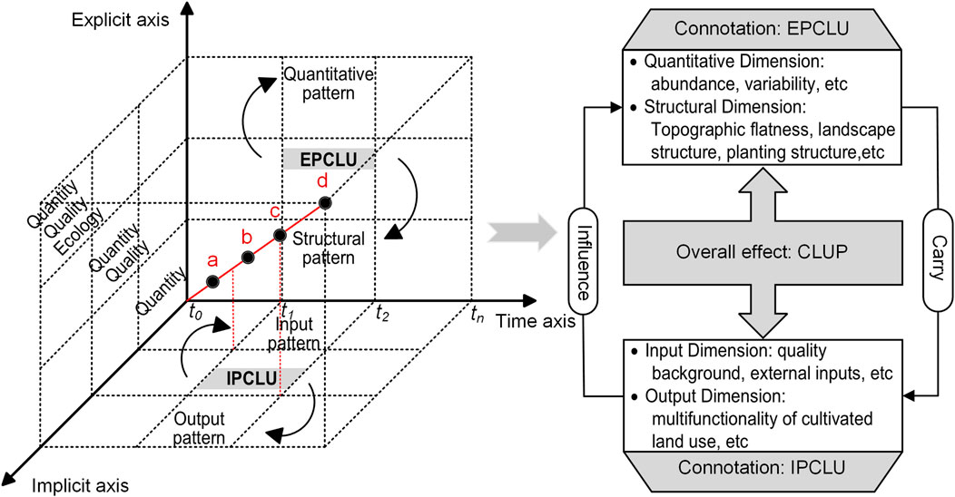
Figure 1. Conceptual framework and specific connotations of CLUP.
3 Materials and methods
3.1 Study area
Given data availability, the Northeast China region studied in this paper primarily covers three provinces: Heilongjiang, Jilin, and Liaoning (Figure 2), with municipal-scale units as the research scope. The study area is located at higher latitudes, characterized by a temperate humid and semi-humid monsoon climate with moderate annual precipitation and suitable sunlight. Crop rotation systems are mostly single-cropping per year, dominated by staple food crops such as maize, soybean, and rice. The region features flat terrain with extensive plains, fertile black soil high in organic matter content, and unique conditions for agricultural production. Cultivated land accounts for approximately 1/5 of China’s total arable land, producing 1/3 of national grain output and 1/4 of commercial grain exports. Agriculture is undergoing a critical transition from high-growth to high-quality development, serving as the “ballast stone” and “voltage stabilizer” for ensuring national food security (Zhang et al., 2023).
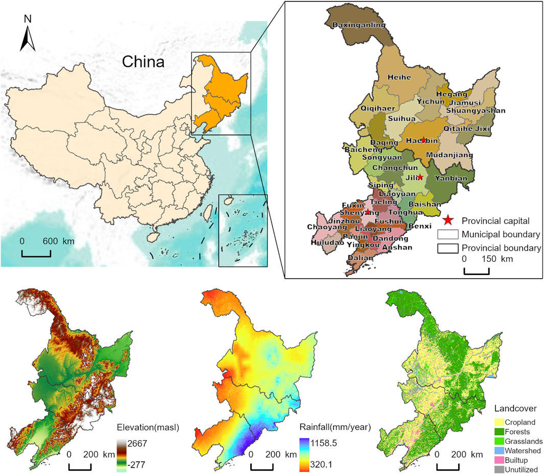
Figure 2. Overview of study area. Approved map no. GS (2023)2767. The map in this figure is based on the standard map (GS (2023)2767) issued by the Ministry of Natural Resources of the People’s Republic of China (http://bzdt.ch.mnr.gov.cn/).
3.2 Data source
The data sources of this paper are as follows: (1) Socioeconomic data used are sourced from China Rural Statistical Yearbook, China Urban Statistical Yearbook, China Regional Economic Statistical Yearbook, Statistical Yearbooks of relevant provinces and cities, as well as statistical bulletins on national economic and social development. (2) Land use data are obtained from the Chinese Multi-temporal Land Use/Land Cover Remote Sensing Monitoring Dataset (CNLUCC) provided by the Resources and Environment Science and Data Center of the Chinese Academy of Sciences (https://www.resdc.cn/Default.aspx), with a spatial resolution of 30 m for extracting cultivated land quantity and spatial structure data. (3) DEM data are derived from the SRTM dataset of the above-mentioned data center, with a spatial resolution of 30 m for slope data extraction. (4) The organic carbon content data of the soil surface layer are derived from the Harmonized World Soil Database (HWSD v2.0) (http://webarchive.iiasa.ac.at/), with a spatial resolution of 1 km. (5) NDVI data are derived from the MOD13A3 dataset of NASA (https://www.earthdata.nasa.gov/), with a temporal resolution of monthly and a spatial resolution of 1 km. In the preprocessing of NDVI data, first, quality flag checks are conducted on the original monthly data to eliminate low-quality pixels. Then, based on the qualified data of 12 months each year, annual NDVI data are synthesized by taking the annual maximum value, so as to more effectively reflect the vegetation coverage status. For individual missing data, the linear interpolation method is used for supplementation.
3.3 Research methods
3.3.1 Construction of evaluation index system
3.3.1.1 Selection of evaluation indices
Based on the conceptual connotations of the above “EPCLU-IPCLU” (Figure 1), referring to existing studies (Wang and Yu, 2023; Zhou Y. et al., 2024; Li and Yang, 2024), integrating the regional demands for black soil protection and food security in Northeast China, and considering the availability of multi-source data, an evaluation index system for CLUP covering EPCLU and IPCLU was constructed (Table 1) to achieve a quantitative analysis of the collaborative mechanism of EPCLU and IPCLU. Among them, EPCLU is characterized by two dimensions of quantity and structure to reflect the specific spatial conditions of the cultivated land use system. IPCLU is characterized by input and output dimensions, to reflect the external influences exerted by the external environment and human activities on the cultivated land use system. At the quantitative level, the total cultivated land area, per capita cultivated land area, and land reclamation rate are selected to reflect the abundance of cultivated land quantity. At the structural level, the average slope gradient within cultivated land, the proportion of patch area in the landscape, the aggregation index, and the grain-to-economic crop ratio are selected to reflect the spatial structure, landscape structure, and planting structure of cultivated land. At the input level, the average content of topsoil organic carbon within cultivated land, the fertilizer application amount per unit area, the labor quantity per unit area, the proportion of effective irrigation facilities, and the total mechanical power per unit area are selected to reflect the nutrient background of cultivated land and the quantity and structure of production factors invested by cultivated land users. At the output level, the grain yield per unit area, agricultural GDP per unit area, per capita grain security rate, per capita agricultural GDP of agricultural practitioners, and the average NDVI (Normalized Difference Vegetation Index) within cultivated land are selected to reflect the beneficial attributes, the quantity of benefits, and the structure of benefits that are conducive to social development resulting from the interaction between cultivated land and external environment (Zhou G. et al., 2024).
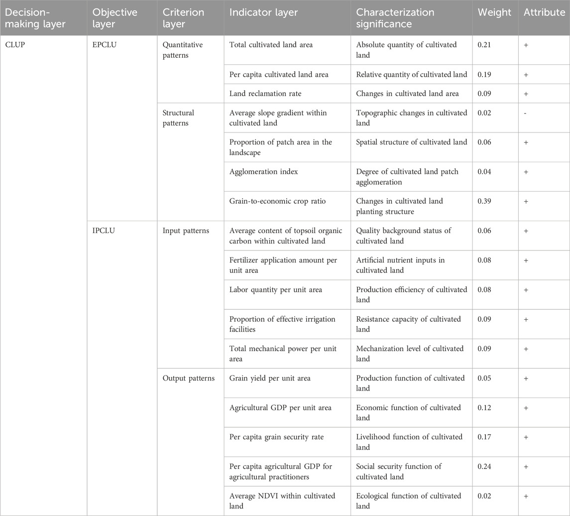
Table 1. Evaluation index system for CLUP.
3.3.1.2 Determination of index weights
Standardization of indicators. Considering that the evaluation index system constructed in this study includes positive and negative indicators, to eliminate the impact of differences in indicator dimensions on the evaluation results, range standardization is adopted to conduct normalization process on the original data. The calculation formulas for positive and negative indicators are shown in Equations 1, 2 below:
Where:
Method for determining weights. Since multiple influencing factors are involved, to avoid defects caused by traditional subjective weighting methods, weights are assigned to each indicator via the objective entropy weight method. This method relies on the information entropy theory, and determines weights by computing the degree of dispersion of each indicator value. A larger variation degree leads to a smaller entropy value and a higher weight, thereby more scientifically reflecting the real contribution of indicators in the comprehensive evaluation. The main steps are as follows Equations 3–6:
Where:
3.3.1.3 Calculation of CLUP value
Based on standardized results and weights of indicators, weighted summation method is used to calculate the EPCLU value (
Where:
3.3.2 Coupling coordination degree model
To scientifically reveal the interactive coupling relationship and coordinated development level between EPCLU and IPCLU in Northeast China, this study introduces the coupling coordination degree model. Originating from the system coupling theory, this model is commonly used to measure the interaction strength and coordination level between multiple systems or subsystems, and is especially applicable to evaluating the overall coordination status among subsystems of different dimensions (Chen et al., 2025). In the model, the coupling degree (
Where:
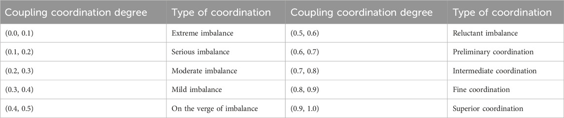
Table 2. Classification table of coupling coordination degree types.
3.3.3 Kernel density estimation
The kernel density estimation method possesses non-parametric characteristics. It does not require presetting a distribution or constructing a parametric model, and can estimate the probability density distribution of random variables through a smoothing function. This method clearly reveals the distribution pattern, evolutionary characteristics, and regional differences of variables in the temporal dimension, making it suitable for analyzing the spatiotemporal evolution and polarization trend of the coupling coordination level. This study conducts analysis based on the Stata 17 software platform and adopts the optimized Silverman’s rule of thumb by default to automatically calculate the bandwidth. A sensitivity test was carried out, in which bandwidths slightly larger and smaller than the default value were selected respectively for comparison. The results show that the density curve generated by the default bandwidth can not only clearly reflect the evolutionary trend of the distribution pattern but also effectively avoid the problems of over-smoothing or over-fitting, thus exhibiting good statistical robustness and explanatory power. Accordingly, this study estimates and characterizes the dynamic evolution process of the coupling coordination degree of EPCLU and IPCLU in Northeast China from 2000 to 2020. The calculation formula is shown as Equation 12:
Where:
3.3.4 Gear-coupled regional type classification method
Referring to existing research paradigms (Zhou Y. et al., 2024), this study employs a multi-dimensional gear coupling classification method to identify and classify regional types. First, the EPCLU values (
Table 3. Classification system for regional types of CLUP.
4 Results
4.1 Analysis on the evolution characteristics of the spatiotemporal pattern of “EPCLU-IPCLU”
According to the measurement results of the previous data, the spatial differentiation pattern can be intuitively displayed with the help of ArcGIS Pro software, so as to analyse the temporal and spatial evolution characteristics of the “EPCLU-IPCLU” in Northeast China from 2000 to 2020 (Figure 3).
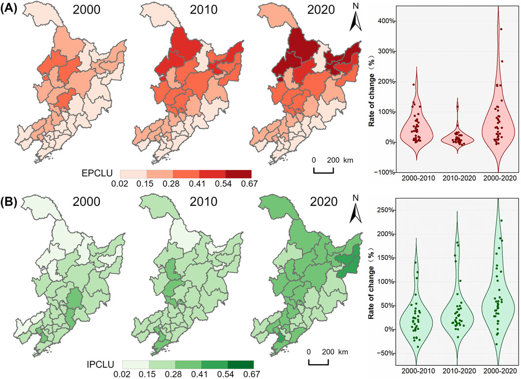
Figure 3. Spatial pattern evolution of EPCLU (A) and IPCLU (B) in Northeast China from 2000 to 2020. Approved map no. GS (2023)2767.
In 2000, the values of CLUP in the study area were generally concentrated in the range of 0.02–0.28, and the overall level was relatively low. Among them, the EPCLU showed a low degree of differentiation across regions, with the low values of 0.02–0.15 being dominant. Supported by the superior natural background of the Songliao Plain, the areas with better performance were clustered in sheets in the western part of the study area, whereas the eastern border areas performed poorly. The IPCLU presented an opposite pattern to EPCLU. The areas with better performance were mostly concentrated in the east, characterized by “high in the southeast and low in the northwest”, and the relatively low values of 0.15–0.28 occupied the dominant position. By 2010, the differentiation trend of EPCLU had intensified, and the region with values ranging from 0.28 to 0.54 expanded significantly, forming a gradient pattern of “high in the northwest and low in the southeast”. This change is mainly attributed to the demarcation of permanent basic farmland, the strict enforcement of the cultivated land occupation-compensation balance policy, and the systematic promotion of land improvement projects. In the meantime, the large-scale non-agricultural transfer of rural labor has effectively alleviated the man-land contradiction, jointly promoting the overall improvement of EPCLU. By comparison, the differentiation of IPCLU is relatively slow, and most units in the study area remain at a low level, with no significant breakthrough in spatial differentiation. In 2020, the EPCLU continued to show spatial differentiation with high values in the northwest and low values in the southeast. Heilongjiang Province in the north formed a polarized high-value area relying on the advantages of cultivated land resource endowment and intensive management, while Liaoning Province in the south showed a slow development trend due to the squeeze of urbanization, and Jilin Province was in the transitional zone. During this period, IPCLU displayed a trend of large-scale accelerated differentiation, with most units in the study area expanding to the range of 0.28–0.41. This breakthrough change originates from the deep integration of regional economic development with agricultural modernization. The improvement of market mechanisms facilitates the optimal allocation of production factors; technological innovation promotes the increase in modern inputs like biological pesticides and intelligent equipment; and large-scale operation markedly enhances land output efficiency. All of these together form the core driving force for the upgrading of IPCLU.
From the perspective of the temporal evolution of the study area between 2000 and 2020, EPCLU exhibited the characteristics of gradual optimization, with the basic spatial pattern of “high in the northwest and low in the southeast” remaining consistent. It was steadily improved by the combined driving forces of policy intervention and natural endowments. The IPCLU, however, displayed distinct characteristics of phased scale upgrading. In the early period, its development was sluggish due to the constraint of factor accumulation; in the later period, it realized significant regional expansion under the dual impetus of technology and market. This law of coordinated evolution, featuring the steady optimization of EPCLU and the phased large-scale upgrading of IPCLU, fully confirms the theoretical hypothesis proposed above. It deeply embodies the dialectical unity of the basic stability of “land” in the cultivated land use system and the behavioral initiative of “humans” during the process of rapid urbanization. It profoundly reflects the dialectical unity between the basic stability of “land” in the cultivated land use system and the behavioral initiative of “humans” during the process of rapid urbanization.
4.2 Analysis on the coupling characteristics of “EPCLU-IPCLU”
Based on the measurement results of coupling coordination degree in 2000, 2010 and 2020, ArcGIS Pro software is used to analyze the spatial evolution characteristics of the coupling coordination degree of the “EPCLU-IPCLU” in Northeast China (Figure 4).
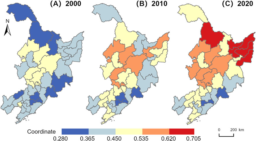
Figure 4. Spatial characteristics of coupling coordination degree of “EPCLU-IPCLU” in Northeast China from 2000 to 2020 (A–C). Approved map no. GS (2023)2767.
As can be seen from the spatial visualization results in Figure 4, the coupling coordination in Northeast China shows a continuous optimization trend, but the coordination level among regions exhibits a clustered polarized distribution feature in space. Areas with relatively low coupling coordination have consistently concentrated in the southeast. However, regions with relatively better coordination have gradually expanded northward from the central area, forming a distribution pattern with high-value clusters on both the eastern and western sides, bounded by Yichun. This spatial distribution is similar to EPCLU. From the perspective of provincial regions, the coupling evolution trends vary. Among them, Heilongjiang Province has seen a continuous rise in coupling coordination and now ranks first in the region. This is attributed to its endowment of high-quality cultivated land resources and the quality-oriented agriculture development strategy actively promoted by the local government. Through invigorating agriculture with science and technology, the intensive transformation of cultivated land use is accelerated, which effectively strengthens the positive interaction between EPCLU and IPCLU. Jilin Province is slightly behind Heilongjiang, but it also shows a deepening trend in the process of agricultural modernization, highlighting the positive radiating potential of urbanization for agricultural development. Liaoning Province has a marked gap compared with Heilongjiang and Jilin Provinces. In the future, it is necessary to coordinate the paths of agricultural modernization and sustainable development. On the basis of ensuring the grain production capacity of urban agglomerations, priority should be given to promoting ecological restoration in the eastern Liaoning mountainous and hilly areas and the construction of factor substitution mechanisms, so as to resolve the structural imbalance where implicit advantages are difficult to compensate for explicit shortcomings, and ultimately achieve in-depth collaborative optimization of the EPCLU and IPCLU.
To further reveal the spatial evolution trend of coupling coordination degree, spatial trend distribution maps of Northeast China for 2000, 2010 and 2020 are drawn based on MATLAB software, as shown in Figures 5A–C. Overall, the coupling coordination degree in Northeast China showed a spatial distribution characteristic of “high in the middle and low in the surrounding areas” from 2000 to 2010, and evolved into a pattern characteristic of “gradient decreasing from northeast to southwest” by 2020. At the local scale, the coupling coordination degree is characterized by a multi-core agglomeration distribution, with its change trend showing a wavy uplift and undulating spatial heterogeneous structure in the cross-section. In terms of the temporal trend, the fluctuation degree of the trend surface in the central and northern regions has shown a significant convergence overall, which indicates that the low-value areas are converging towards the high-value areas, and regional differences are gradually shrinking and evolving towards a balanced state. It is worth noting that the surface uplift in the northeastern region is particularly prominent, with the north-south profile gradually transforming from a “W” shape to a “V” shape, indicating that the coupling coordination degree in the northeastern part of Heilongjiang Province is accelerating. In contrast, the fluctuation of the trend surface in the southern region is small, and the east-west profile remains in a “W” shape, indicating that the growth trend in this region is relatively slow with significant imbalance.
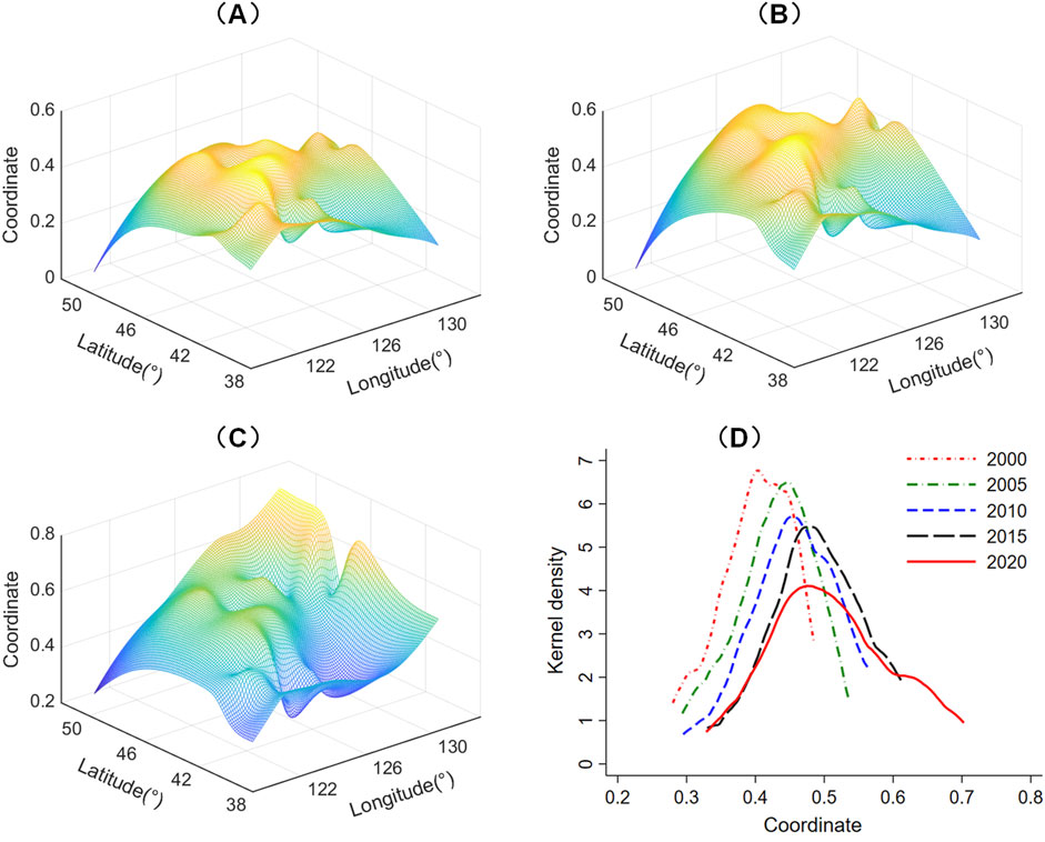
Figure 5. Spatial trend map (A–C) and temporal evolution characteristics (D) of coupling coordination degree in Northeast China from 2000 to 2020. Approved map no. GS (2023)2767.
In addition, the temporal evolution characteristics of the coupling coordination degree in the study area are depicted based on the kernel density estimation method, as presented in Figure 5D. From the perspective of distribution position, the center of gravity of the curve continues to shift to the right, roughly moving from 0.4 to around 0.5, reflecting the continuous rise of the overall coupling coordination degree level. In terms of distribution shape, the curve is characterized by a decrease in peak height and an increase in width, with the gap between cities with higher coupling coordination degree and those with lower ones widening, implying that the absolute difference in regional coupling coordination degree tends to expand. The number of peaks showed a double-peak structure with one main peak and one secondary peak in 2000, 2010 and 2020, but the difference between the peaks was slight, still reflecting the spatial pattern dominated by single polarization. In terms of distribution extensibility, the sharp reduction in the thickness of the left tail indicates a decrease in the number of low-value areas with respect to coupling coordination degree; the enhanced extension of the right tail reflects the upgrading of the energy level of high-value areas, achieving a “zero breakthrough” in primary and intermediate coordination types. In general, the level of coupling coordination degree in the study area keeps increasing, evolving into a more coordinated and efficient state, yet the characteristic of single-polar concentration is still significant. This evolutionary trend is closely linked to the deepening of the nation’s cultivated land protection. Particularly after the implementation of the “trinity” high-quality protection strategy, systematic measures including cultivated land quality construction, spatial pattern optimization, and manifestation of multi-functional values have effectively boosted the optimization and upgrading of the coordination degree between EPCLU and IPCLU.
4.3 Study on the regional characteristics of CLUP
Based on the classification threshold determination results of the gear coupling method (Table 4), the CLUP in Northeast China can be categorized into five regional types (Figure 6): CST, EDT, IDT, GDT, and CWT. Each type exhibits distinct regional distribution characteristics.
Table 4. Threshold for the classification of regional types of CLUP.
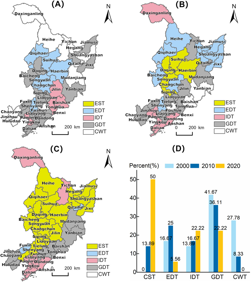
Figure 6. Distribution map of regional types (A-C) and spatial percentage map (D) of CLUP in Northeast China from 2000 to 2020. Approved map no. GS (2023)2767.
The CST is characterized by an AA coupling state featuring double excellence in EPCLU and IPCLU, i.e., the developmental level of units belonging to this type in both dimensions is markedly better than that of most other units in the study area in the same period. From the perspective of its distribution, it shows a significant expansion trend. In 2010, CST first appeared in the central-northern Songnen Plain, forming an initial agglomeration area with Harbin-Suihua-Daqing-Songyuan-Siping as the core. In 2020, it realized full-region expansion, with the spatial proportion leaping to 50%, and established the main framework of the “Golden Corn Belt” along the Hadaqi Industrial Corridor, extending through the Songnen Plain, Liaohe Plain, and Sanjiang Plain. In terms of distribution evolution, the combined effect of natural foundation and institutional innovation serves as the dual driving force for CST. Located in the Songliao Plain, it possesses threefold advantages of cultivated land endowment index, topographic flatness, and soil quality, providing fundamental support for contiguous large-scale management. The policy-guided construction of high-standard farmland and industrial chain integration further enhance system resilience, promoting a high-level synchronous development trend of EPCLU and IPCLU. For regions of CST, it is necessary to construct a two-way empowerment development system in the future. The focus is on strengthening the interactive feedback mechanism between EPCLU and IPCLU, achieving a “high scale-high benefit” dual-excellence pattern through the integration of smart agriculture technologies and black soil conservation projects, and establishing a demonstration zone for agricultural modernization in Northeast China.
The EDT exhibits an evolutionary trend of “core polarization-gradient transfer-spatial convergence”. In 2000, it was concentrated in the central-northern part of the study area. After 10 years, the agglomeration spread to the surrounding area. By 2020, the distribution units have been sharply reduced to 5.56%, and only Qitaihe and Fuxin exist, resulting in a structural reconfiguration of the spatial pattern. The evolution essence of EDT is caused by regional development gradient differences. At the initial stage of the study, it was primarily attributed to the exceptional natural conditions. Situated in the Songliao Plain, cultivated land was innately abundant. Furthermore, the large-scale outflow of rural population and the execution of the Black Soil Protection Project allowed cultivated land to maintain or enhance its original favorable condition. However, with the changes and adjustments of input factors in cultivated land production brought about by regional economic development, the original core areas like Harbin and Suihua formed a spatial substitution effect, and transformed from the EDT to the CST by virtue of the leap in implicit quality. For regions with EDT, cultivated land exhibits significant advantages in quantity and spatial structure, making it more suitable for large-scale agricultural mechanized farming. Yet in practical application, the IPCLU often falls behind the development of the EPCLU, being confronted with the development predicament of “EPCLU-IPCLU imbalance”, which hinders the high-level release of cultivated land use benefits and potential. Therefore, future efforts should focus on the adaptation of structure and function, leveraging concentrated resources and technological advantages to resolve the “high scale-low efficiency” dilemma, and achieve coordinated development between sustainable cultivated land utilization and agricultural modernization.
The IDT shows an expansion trend of “expanding southward and advancing northward”. During the study period, this type was mainly distributed in the southern part of the study area in an agglomerated form, relying on the advantages of soil fertility, irrigation, machinery, labor, as well as grain production and revenue in the distribution areas. It is noteworthy that among the above distribution units, only Tonghua and Baishan in Jilin Province experienced type degradation, regressing from the IDT in 2000 to the GDT in 2020. This is due to the fact that in the process of urban industrialization and urbanization, the transformation of population, economic, and employment structures have led to the gradual dissipation of agricultural labor advantages, while the growth of mechanical power has failed to make up for the input gaps in a timely manner, triggering an imbalance in factor substitution. In addition, nutrient restrictions under ecological policy constraints in recent years have also weakened traditional input advantages, leading to a decrease in grain, economic, and social outputs of cultivated land. With regard to the development of IDT, it is necessary to guard against the contradiction of “high input-low sustainability”. By accelerating agricultural mechanization and modernization, capital can replace labor, so as to preventing potential input waste and cultivated land abandonment. Furthermore, the ecological service value of cultivated land should be improved as much as possible to achieve the coordinated development of agricultural production and ecological environment protection.
The CWT presents the characteristics of spatial marginalization and multi-dimensional coupled disadvantages. In 2000, it was concentrated in the northern edge of the study area, the eastern border, and the southern provincial adjacent belt, forming a marginalized spatial pattern of “three zones surrounding”, and the spatial proportion of the study area drastically decreased to 8.33% in 2010, with a small number of units only existing in the eastern border. By 2020, CWT completely withdrew from the study area. This spatial-temporal evolution trajectory reflects the stage-by-stage success of cultivated land protection and construction in the Northeast China, but the dominant role of policy intervention in the dissipation mechanism is much higher than the role of natural recovery, and the risk of reverse degradation of marginal cultivated land still needs to be watched out for in the future. Analyzed from the perspective of system coupling, the nature of CWT is the result of the collaborative effect of natural background constraints and insufficient human intervention. Therefore, it performs poorly in the two-dimensional patterns of cultivated land use, with many shortboards and disadvantageous indicators, and the interaction between factors is prone to generate negative synergistic effects, accelerating its development into CWT. From the above-mentioned regions, the common causes are insufficient artificial nutrient input, low investment in agricultural mechanization, and poor nutrient background, irrigation facilities, and labor input in some units, which in turn lead to generally low outputs in terms of cultivated land production, economy, livelihood, social security, and ecological benefits. In addition, the absolute quantity, relative abundance, topographic flatness, and landscape pattern of cultivated land also show average performance or are at a disadvantage, further exacerbating its comprehensive weak situation. In areas where the two-dimensional patterns of such cultivated land are both in a weak state, establishing a transmission system of “natural restoration-artificial regulation-functional value enhancement” can effectively resolve the coupling effect of multi-dimensional disadvantages and promote the transformation of marginal cultivated land toward efficient and sustainable utilization.
Except for the aforementioned types, the remaining regions are classified as the GDT. As a transitional type, GDT is widely distributed within the study area, with the number of distribution units taking the main position in the study area in 2000 and 2010. By 2020, its dominant position was completely replaced by CST, and the distribution units were reduced to 22.22%, showing a zonal distribution along the eastern border and southern provincial boundaries. For such regions, vigilance is required against the risk of reverse succession into CWT. Efforts should prioritize their transformation into EDT or IDT to ensure sustainability of cultivated land utilization and the stability of agricultural production.
Overall, by 2020, the regional types of cultivated land use patterns in Northeast China had formed a distinct differentiation pattern, characterized by “high in the west and low in the east” polarized development. Wherein, the type improvement in Heilongjiang and Jilin Provinces was significant, while the succession process of most units in Liaoning Province was relatively slow. Specifically, CST was concentrated in the left zone along the “northeast-southwest” axis of the study area, EDT exhibited a small scattered distribution, IDT was mainly agglomerated in southern Liaoning Province, and GDT filled the remaining marginal regions. This phenomenon fundamentally represents a spatial projection of combined effect from geomorphological constraints, policy gradient effects, and economic factor flows. Future measures should be tailored to local conditions to achieve efficient utilization and benign development of cultivated land.
5 Conclusion
From the perspective of cultivated land use, this paper profoundly interprets the connotation of CLUP starting from the “EPCLU-IPCLU”, and constructs a comprehensive evaluation index system accordingly. Taking Northeast China as an example, it reveals the spatial differences and coupling characteristics of EPCLU and IPCLU from 2000 to 2020, and on this basis, divides the regional types of CLUP in the study area through the multi-dimensional gear coupling method. The research conclusions are as follows:
1. Spatiotemporal pattern evolution characteristics of “EPCLU-IPCLU”: From 2000 to 2020, the spatiotemporal evolution of EPCLU and IPCLU in Northeast China presented obvious differentiation laws. Constrained by the rigidity of natural endowments and policy intervention, EPCLU shows the characteristics of gradual and steady optimization, and maintains a basic spatial pattern of “high in the northwest and low in the southeast”. However, IPCLU shows significant characteristics of phased scale improvement. In the early stage, its development was delayed due to the limitation of factor accumulation; in the later stage, it achieved substantial regional expansion driven by the dual wheels of technological penetration and improvement of market mechanisms.
2. Coupling characteristics of “EPCLU-IPCLU”: The coupling coordination degree between the “EPCLU-IPCLU” in Northeast China has continuously increased, evolving towards a more coordinated and efficient state. Spatially, it presents a significant clustered polarized distribution feature. Regions with relatively poor coupling coordination are always clustered in the southeast, while regions with relatively better coordination gradually spread northward from the central part, forming a pattern characteristic of “gradient decreasing from northeast to southwest”. At the provincial level, it is manifested as Heilongjiang Province > Jilin Province > Liaoning Province. As time goes by, the differences in coupling coordination degree in the central and northern regions have gradually shrunk and evolved towards a balanced state, while the imbalance in the southern region is still prominent.
3. Regional classification of CLUP: The study area exhibits five regional types of CLUP. Among them, CST is widely distributed in the study area in the form of agglomerative expansion. Affected by the regional development gradient, EDT shows a trend of first rising, then falling, and overall convergence. IDT increases gradually over time, presenting an evolutionary trend of “expanding southward and advancing northward”. CWT is characterized by spatial marginalization and multi-dimensional coupling disadvantages, with the number of distribution units is gradually dissipating. Serving as a transitional type, GDT fills most of the remaining regions and shows a slow decreasing trend.
6 Discussion
Based on the systematic analysis of the key issues concerning the “EPCLU-IPCLU” in Northeast China mentioned above, future regional cultivated land management strategies should be based on regional weaknesses and adopt differentiated regulation to advance the overall optimization of the pattern structure. For regions with sound development in a single pattern dimension, efforts should be made to accelerate the improvement of weak dimensions on the basis of consolidating existing advantages, break through system bottlenecks, and achieve a high-level synergy between explicit efficiency and implicit support capacity. Specifically, regions categorized as the EDT have flat topography and good basic cultivated land productivity, while their ecosystem stability is relatively low, and they confront an outstanding conflict between the degradation of ecological functions and intensive production. To address this, under the precondition of strict protection of high-quality cultivated land resources, it is necessary to comprehensively advance the integrated management path emphasizing both ecological transformation and intensive upgrading. Focus on developing large-scale operation, industrial structure optimization, and the application of green and low-carbon technologies, strengthen the collaboration among multi-level operating entities at the municipal, county, and town levels, and enhance the driving capacity of the entire agricultural industrial chain. Among these regions, Fuxin may leverage the policy benefits of the dryland agriculture demonstration zone to prioritize the development of a system of large-scale and mechanized cultivation of distinctive coarse cereals including sorghum and millet, comprehensively promote technologies for water conservation, moisture retention and soil improvement such as full-film double ridge furrow seeding, and achieve coordinated development of productivity enhancement and ecological preservation. Qitaihe, by contrast, may take advantage of the opportunities of resource-based city transition to vigorously develop green organic agriculture, promote the corn-soybean rotation demonstration project, integrate land improvement and property right integration measures, progressively resolve the issue of cultivated land fragmentation, and strengthen the regional ecological carrying capacity and the ability of sustainable agricultural development.
Regions of the IDT face dual restrictions from a weak inherent base of cultivated land resources and urban functional orientation. For their future development, efforts should be promoted in a systematic way centering on three levels: infrastructure-industrial chain-urban-rural integration. On one hand, it is necessary to continuously strengthen the comprehensive supporting of infrastructure such as farmland, soil, water conservancy, roads, forest networks and electricity facilities, actively advance the project of “merging small plots into large ones” and land parcel integration, increase agricultural subsidies and targeted capital investment, so as to provide a solid foundation for improving cultivated land quality, large-scale operation and the construction of high-standard farmland. On the other hand, it is essential to give full play to the advantages of urban technology, capital and markets, focus on developing high value-added modern agriculture, accelerate the construction of cold-chain storage and logistics systems, and comprehensively improve the integrated capacity for agricultural product production, fresh-keeping, storage-transportation and sales. Taking Dalian as a case in point, it may leverage the policy platform of Jinpu New District to proactively popularize digital technologies like intelligent irrigation and precise fertilization, build a modern agricultural industrial park for high-end fruits and vegetables, drive deep integration between agriculture and urban functions, and strengthen regional agricultural resilience and competitiveness. This development path has similar logic to the “Southern Jiangsu Model” (Cao and Li, 2024), both demonstrating the effective nourishment of agricultural modernization by urban resources. It is worth paying special attention to that the Greater Khingan Range region has prominent ecological functions but limited cultivated land resources. On the premise of strictly protecting the ecosystem, it should moderately maintain the production capacity of cultivated land and actively explore the integration path of ecological agriculture-forestry, characteristic planting and digital agriculture.
Regarding GDT regions, the coordination level of the EPCLU and IPCLU is generally insufficient. The underlying cause is that there are significant deficiencies in the natural inherent foundation of cultivated land and the input of modern factors, which hinder the enhancement of cultivated land fertility and resource use efficiency, and thereby impact output performances including grain yield per unit and agricultural GDP. Such regions can draw on the common experience of implementing measures based on local conditions and achieving characteristic breakthroughs in the “adaptive development” path of southwestern mountainous agricultural areas (Dong et al., 2023), that is, prioritizing the selection of advantageous dimensions for focused cultivation according to local resource endowments. However, the essential difference between Northeast China and the southwestern mountainous areas lies in the fact that Northeast China faces unique risks of black soil degradation and soil hardening. The key challenges for agriculture in the southwestern mountains are fragmented terrain and the difficulty of applying mechanization, while the primary contradiction in the black soil area of Northeast China is how to preserve topsoil organic matter and prevent the degradation of ecological functions in the course of large-scale management. Consequently, when advancing large-scale agricultural management in Northeast China, greater focus must be placed on ecological transition, with conservation tillage and the enhancement of cultivated land fertility serving as the core of coordinated development. In detail, this can be achieved by restoring the natural vegetation of farmland, promoting conservation tillage systems such as the “Lishu Model”, and integrating measures like crop rotation to enhance the ecosystem’s capabilities in water conservation, soil health preservation, and carbon sequestration. This enables the establishment of a Northeast-specific governance model characterized by “large-scale management as the basis, protective tillage as the technique, and ecological function synergy as the target,” thus achieving the enhancement of production capacity alongside the improvement of the ecological resilience of cultivated land.
Additionally, during the optimization process of CLUP, spatial dependency characteristics should be fully considered to optimize inter-regional factor flows (Sun Y. et al., 2025), including human capital, technological resources, and material resources. Based on the “point-axis” system theory (Lu, 2002), priority should be given to hub cities with developed economies and perfect transportation networks such as Shenyang and Changchun. These cities should be cultivated into core growth poles for agricultural production factors, forming complete agricultural industrial chain clusters to exert radiating effects of core demonstration zones. Subsequently, building upon axes such as the Shenyang-Dalian Economic Belt, development of node areas can be promoted. Following the optimization concept of “core radiation-axis expansion-district integration,” a multi-level linkage network should be constructed to achieve rational allocation and efficient flow of agricultural production factors among regions, promoting comprehensive improvement of CLUP and coordinated development of regional agriculture in Northeast China. Finally, limitations of this study include: ① The indicator system characterization needs improvement. Constrained by data availability, existing indicators fail to fully represent the rich connotations of IPCLU, lacking characterization of attributes such as management entity behaviors (e.g., the degree of part - time farming) and property rights structures (e.g., contract right transfer rates). Future studies should incorporate farmer survey data to improve measurement accuracy. ② Regional classification precision requires enhancement. Current gear coupling models primarily rely on statistical thresholds for type identification without integrating spatial heterogeneity factors such as topographic continuity and policy gradients.
Data availability statement
Publicly available datasets were analyzed in this study. This data can be found here: https://www.resdc.cn/Default.aspx.
Author contributions
NW: Conceptualization, Writing – review and editing, Visualization, Writing – original draft, Formal Analysis, Validation, Methodology. JN: Writing – review and editing, Supervision, Funding acquisition, Conceptualization, Resources. YS: Writing – review and editing, Methodology, Data curation, Conceptualization. MW: Software, Writing – review and editing. HM: Writing – review and editing, Validation.
Funding
The author(s) declare that financial support was received for the research and/or publication of this article. This research was funded by National Natural Science Foundation of China, grant number 41971217.
Conflict of interest
The authors declare that the research was conducted in the absence of any commercial or financial relationships that could be construed as a potential conflict of interest.
Generative AI statement
The author(s) declare that no Generative AI was used in the creation of this manuscript.
Any alternative text (alt text) provided alongside figures in this article has been generated by Frontiers with the support of artificial intelligence and reasonable efforts have been made to ensure accuracy, including review by the authors wherever possible. If you identify any issues, please contact us.
Publisher’s note
All claims expressed in this article are solely those of the authors and do not necessarily represent those of their affiliated organizations, or those of the publisher, the editors and the reviewers. Any product that may be evaluated in this article, or claim that may be made by its manufacturer, is not guaranteed or endorsed by the publisher.
References
Cao, K., and Li, J. (2024). Exploration of a rural spatial governance model in southern Jiangsu from the perspective of urban-rural relationship evolution: a case study of tianning district, Changzhou. Urban Plan. Forum, 173–178. doi:10.16361/j.upf.202407025
Chai, C., Zhang, B., Li, Y., Niu, W., Zheng, W., Kong, X., et al. (2023). A new multi-dimensional framework considering environmental impacts to assess green development level of cultivated land during 1990 to 2018 in China. Environ. Impact Assess. Rev. 98, 106927. doi:10.1016/j.eiar.2022.106927
Chen, Y., Wang, J., Zhang, F., Liu, Y., Cheng, S., Zhu, J., et al. (2021). New patterns of globalization and food security. J. Nat. Resour. 36, 1362–1380. doi:10.31497/zrzyxb.20210602
Chen, F., Jiang, F., Sun, J., Guo, W., Ma, J., and Zhu, X. (2024). Logic and innovative practice of cultivated land protection transformation in the context of large-scale balancing cultivated land occupation and reclamation reform. China Land Sci. 38, 12–24. doi:10.11994/zgtdkx.20241014.081512
Chen, F., Li, Y., and Liu, Y. (2025). Spatial-temporal evolution and coupling coordination of land use functions across China by fusing multiple-source heterogeneous data. Land Use Policy 155, 107590. doi:10.1016/j.landusepol.2025.107590
Dong, T., Yang, C., Zhong, S., Li, L., Shi, Y., and Wei, C. (2023). Spatial distribution and protection zoning of cultivated land quality improvement potential in mountainous and hilly regions:a case study of Jiangjin District, Chongqing City. J. Agric. Resour. Environ. 40, 165–177. doi:10.13254/j.jare.2021.0679
Du, G., Chai, L., and Li, Y. (2022). Theoretical explanation and research framework of cultivated land use system. Prog. Geogr. 41, 1288–1299. doi:10.18306/dlkxjz.2022.07.012
Feng, D., and Long, H. (2025). Transition of farmland use system towards urban-rural integration: from localization to de-localization. Resour. Sci. 47, 42–53. doi:10.18402/resci.2025.01.04
Gao, J., and Yang, Y. (2023). Causes and temporal heterogeneity of land use/land cover changes around high-speed railway stations: a case study of Hainan roundabout railway. China Land Sci. 37, 114–134. doi:10.11994/zgtdkx.20230920.150237
Jiang, F., Chen, F., Sun, Y., Hua, Z., Zhu, X., and Ma, J. (2023). Spatiotemporal pattern and driving mechanism of cultivated land use transition in China. Land 12, 1839. doi:10.3390/land12101839
Ke, S., Cui, H., Ge, K., Wang, A., Du, X., and Lu, X. (2024a). Exploring the spatial patterns and driving mechanisms of farmland spatial transition in the Yangtze River Economic Belt. China Land Sci. 38, 99–112. doi:10.11994/zgtdkx.20240611.145353
Ke, X., Chen, J., Zuo, C., and Wang, X. (2024b). The cropland intensive utilisation transition in China: an induced factor substitution perspective. Land Use Policy 141, 107128. doi:10.1016/j.landusepol.2024.107128
Lambin, E. F., and Meyfroidt, P. (2010). Land use transitions: socio-ecological feedback versus socio-economic change. Land Use Policy 27, 108–118. doi:10.1016/j.landusepol.2009.09.003
Li, H., and Yang, M. (2024). “Explicit-implicit” patterns coupling coordination degree of cropland utilization in the farming system of northwest China. Arid. Land Geogr. 47, 1924–1934. doi:10.12118/j.issn.1000-6060.2024.013
Li, Q., Hu, S., and Qu, S. (2017). Spatiotemporal characteristics of cultivated land use transition in the Middle Yangtze River from 1990 to 2015. Geogr. Res. 36, 1489–1502. doi:10.11821/dlyj201708008
Li, X., Wang, H., Niu, W., Han, X., Xing, P., Chai, C., et al. (2024). Spatial-temporal evolution of cultivated land use transition and its impact on grain production in the Yellow River Basin. J. China Agric. Univ. 29, 85–96. doi:10.11841/j.issn.1007-4333.2024.10.07
Li, L., Pan, P., Wang, Y., Wang, X., Wang, X., Xiao, D., et al. (2025). Research on the cultivated land use system resilience under a safe and just space framework. J. Environ. Manag. 380, 125006. doi:10.1016/j.jenvman.2025.125006
Liang, A., Li, L., and Zhu, H. (2021). Protection and utilization of black land and making concerted and unremitting efforts for safeguarding food security promoted by sci-tech innovation —countermeasures in conservation and rational utilization of black land. Bull. Chin. Acad. Sci. 36, 557–564. doi:10.16418/j.issn.1000-3045.20210403002
Liang, X., Jin, X., Xu, X., and Zhou, Y. (2022). A stage of cultivated land use towards sustainable intensification in China: description and identification on anti-intensification. Habitat Int. 125, 102594. doi:10.1016/j.habitatint.2022.102594
Long, H. (2022). Theorizing land use transitions: a human geography perspective. Habitat Int. 128, 102669. doi:10.1016/j.habitatint.2022.102669
Long, H., and Li, X. (2002). Analysis on regional land use transition: a case study in transect of the Yangtze River. J. Nat. Resour., 144–149.
Long, H., and Qu, Y. (2018). Land use transitions and land management: a mutual feedback perspective. Land Use Policy 74, 111–120. doi:10.1016/j.landusepol.2017.03.021
Lu, D. (2002). Formation and dynamics of the “Pole-Axis” spatial system. Geogr. Sci. 22, 1–6. doi:10.13249/j.cnki.sgs.2002.01.1
Lv, T., Fu, S., Zhang, X., Wu, G., Hu, H., and Tian, J. (2022). Assessing cultivated land–use transition in the major grain-producing areas of China based on an integrated framework. Land 11, 1622. doi:10.3390/land11101622
Niu, S., Fang, B., Cui, C., and Huang, S. (2020). The spatial-temporal pattern and path of cultivated land use transition from the perspective of rural revitalization: taking Huaihai Economic Zone as an example. J. Nat. Resour. 35, 1908–1925. doi:10.31497/zrzyxb.20200812
Niu, W., Luo, L., Shi, Y., Chai, C., Wang, H., Tian, Q., et al. (2025). Impacts of “One Household One Plot” and “One Village Group One Plot” fragmentation consolidation models on cultivated land use transition from perspective of human-land system. Habitat Int. 156, 103252. doi:10.1016/j.habitatint.2024.103252
Pang, X., Xie, B., Lu, R., Zhang, X., Xie, J., and Wei, S. (2024). Spatial–temporal differentiation and driving factors of cultivated land use transition in Sino–Vietnamese border areas. Land 13, 165. doi:10.3390/land13020165
Qu, Y., and Long, H. (2018). The economic and environmental effects of land use transitions under rapid urbanization and the implications for land use management. Habitat Int. 82, 113–121. doi:10.1016/j.habitatint.2018.10.009
Qu, Y., Zhan, L., Wei, C., Zhang, Q., and Wang, J. (2024). Interactive transition of cultivated land and construction land during china’s urbanization: a coordinated analytical framework of explicit and implicit forms. Land Use Policy 138, 107049. doi:10.1016/j.landusepol.2024.107049
Šálka, J., Longauer, R., and Lacko, M. (2006). The effects of property transformation on forestry entrepreneurship and innovation in the context of Slovakia. For. Policy Econ. 8, 716–724. doi:10.1016/j.forpol.2005.06.017
Silva, R. F. B. D., Batistella, M., and Moran, E. F. (2017). Socioeconomic changes and environmental policies as dimensions of regional land transitions in the Atlantic Forest, Brazil. Environ. Sci. and Policy 74, 14–22. doi:10.1016/j.envsci.2017.04.019
Song, X. (2017). Discussion on land use transition research framework. Acta Geogr. Sin. 72, 471–487. doi:10.11821/dlxb201703009
Song, X., Shen, Y., Wang, X., and Li, X. (2020). Vulnerability to biological disasters: a novel field of cultivated land use transition research. Acta Geogr. Sin. 75, 2362–2379. doi:10.11821/dlxb202011007
Sun, Y., Ning, J., Sun, T., Wang, N., Wang, M., and Ma, H. (2024). Characteristic analysis of spatial structure of rural territorial system and development types: Taking Bin County of Heilongjiang Province as an example. China Land Sci. 38, 93–104. doi:10.11994/zgtdkx.20241016.084612
Sun, X., Wang, J., Zhu, X., Dong, Y., and Lin, X. (2025a). Transformation of cultivated land utilization and its driving factors based on human-earth system perspective: taking Qiqihar city, Heilongjiang province, as an example. J. Nat. Resour. 40, 350–366. doi:10.31497/zrzyxb.20250205
Sun, Y., Ning, J., and Piao, Y. (2025b). Analysis of the characteristics and agglomeration effect of the rural element spatial correlation network in Northeast China. Land 14, 240. doi:10.3390/land14020240
Wang, M., and Huang, X. (2024). Inhibit or promote: spatial impacts of multifunctional farmland use transition on grain production from the perspective of major function-oriented zoning. Habitat Int. 152, 103172. doi:10.1016/j.habitatint.2024.103172
Wang, L., and Yu, H. (2023). Dominant and recessive transformation pattern and its coupling relationship of cultivated land use in poor mountainous areas: a case study of Naxi Autonomous County, Yulong County, Yunnan Province. Sci. Technol. Eng. 23, 9015–9023.
Wei, X., Guan, J., Feng, X., Wang, S., Zhao, Y., Zhang, Y., et al. (2023). Spatial-temporal change characteristics of cultivated land quality in Shaanxi section of Qinling, China and their driving forces. J. Earth Sci. Environ. 45, 350–361. doi:10.19814/j.jese.2022.05006
Wu, C. (1991). On the core of geographic Research——the regional system of human-land relationship. Econ. Geogr., 1–6. doi:10.15957/j.cnki.jjdl.1991.03.001
Xu, L., Hu, H., Yin, S., Yang, J., and Ma, L. (2023). Spatiotemporal evolution and subarea of cultivated land function supply-demand transition in Hebei Province. Res. Soil Water Conservation 30, 403–412. doi:10.13869/j.cnki.rswc.2023.03.027
Xue, X., and Xie, Y. (2024). The spatial-temporal differences and spatial convergence of ecological in cultivated land utilization in the main grain-producing areas of the Yellow River Basin—evidence from 60 prefecture-level cities. Chin. J. Agric. Resour. Regional Plan. 45, 52–65. doi:10.7621/cjarrp.1005-9121.20240405
Yang, H., Chen, L., Yang, B., and Shi, Z. (2022). Exploring provincial sustainable intensification of cultivated land use in China: an empirical study based on emergy analysis. Phys. Chem. Earth, Parts ABC 128, 103287. doi:10.1016/j.pce.2022.103287
Yang, H., Zou, R., Hu, Y., Wang, L., Xie, Y., Tan, Z., et al. (2024). Sustainable utilization of cultivated land resources based on “element coupling-function synergy” analytical framework: a case study of Guangdong, China. Land Use Policy 146, 107316. doi:10.1016/j.landusepol.2024.107316
Zhang, X., Jin, X., Fan, Y., Liu, J., Dan, W., and Zhou, Y. (2019). Spatial-temporal characteristics and coordination status of the land use function transition in Jiangsu Province from 1995 to 2015. J. Nat. Resour. 34, 689–706. doi:10.31497/zrzyxb.20190402
Zhang, R., Du, G., and Zhang, S. (2023). Spatiotemporal changes and the driving factors of cultivated land resources of the typical black soil region in Northeast China from 1986 to 2020. Resour. Sci. 45, 939–950. doi:10.18402/resci.2023.05.05
Zhou, G., and Long, H. (2023). Three-dimensional measurement and coupling and coordination evolution of recessive land use morphology of rural settlements: a case of Henan Province. Prog. Geogr. 42, 1082–1097. doi:10.18306/dlkxjz.2023.06.005
Zhou, G., Long, H., Ge, D., Xu, L., and Li, S. (2024a). Study on three-dimensional measurement of recessive farmland use morphology and its regional types: a case of the Huang-Huai-Hai Region. Geogr. Res. 43, 180–199. doi:10.11821/dlyj020230392
Zhou, Y., Zhang, E., He, L., Ke, X., Lu, D., Lin, A., et al. (2024b). The carbon emission reduction benefits of the transformation of the intensive use of cultivated land in China. J. Environ. Manag. 370, 122978. doi:10.1016/j.jenvman.2024.122978
Keywords: cultivated land use, explicit pattern, implicit pattern, coupling characteristics, regional types, Northeast China
Citation: Wang N, Ning J, Sun Y, Wang M and Ma H (2025) Study on coupling coordination and regional characteristics of “explicit-implicit” patterns in cultivated land use in Northeast China. Front. Environ. Sci. 13:1686877. doi: 10.3389/fenvs.2025.1686877
Received: 16 August 2025; Accepted: 25 September 2025;
Published: 10 October 2025.
Edited by:
Eduardo Gomes, University of Lisbon, PortugalReviewed by:
Guihai Liu, Jiangxi Normal University, ChinaJiashuang Hou, Nanning Normal University, China
Copyright © 2025 Wang, Ning, Sun, Wang and Ma. This is an open-access article distributed under the terms of the Creative Commons Attribution License (CC BY). The use, distribution or reproduction in other forums is permitted, provided the original author(s) and the copyright owner(s) are credited and that the original publication in this journal is cited, in accordance with accepted academic practice. No use, distribution or reproduction is permitted which does not comply with these terms.
*Correspondence: Jing Ning, am5pbmdAbmVhdS5lZHUuY24=