 Wei Wei1
 Qinghong Xiao1*Yan Bai1Wei Wang1Huibin Wang2Wenna Yang1Yanru Liu1Kunyue Wu1
 Dongbo Wu1Yan Zhao1Xue Gong1
- 1Ningxia Agricultural Comprehensive Development Center, Yinchuan, China
- 2Qingtongxia Agricultural Technology and Mechanization Promotion Service Center, Wuzhong, China
Background: In response to the need for saline-alkali land management in the Ningxia section of the Yellow River Basin, current research is often limited to single indicators or small-scale analyses, lacking a systematic assessment of multi-factor interactions and macro-scale spatial heterogeneity.
Methods: This study selected 13 typical districts and counties in Ningxia. Based on topography, land use, and salinization degree, a stratified random sampling design was employed, resulting in 2,543 sampling points. Multi-source data were integrated, encompassing four main categories: soil (physicochemical properties), topography (area, textural configuration), management (drainage capacity, shelterbelt network, cultivation system), and biology (plant and microbial biodiversity). The Analytic Hierarchy Process (AHP) was used to determine indicator weights. The spatial variation of soil quality was assessed by calculating the Integrated Fertility Index (IFI). Path analysis and JMP power analysis were utilized to quantify the direct, indirect, and interactive contributions of various influencing factors.
Results: Soil salinity and nutrients exhibited a spatial pattern of “higher in the north and lower in the south” with soil quality grades decreasing from north to south. Path analysis identified soil pH, alkali-hydrolyzed nitrogen (AHN), topsoil texture, and drainage capacity as the core factors affecting soil quality. Among these, topsoil texture had the highest contribution (20.47%), and the interaction between pH and AHN was the most significant (4.84%). Areas with high biodiversity highly aligned with regions of low salinity and high organic matter content.
Conclusion: The quality of saline-alkali land is co-regulated by natural factors and human management measures, with topsoil texture and drainage capacity being the key controlling elements. These findings provide a theoretical basis and technical support for the “zoned management and functional coordination” of saline-alkali land in the irrigation areas of Northwestern China.
1 Introduction
Land salinization and alkalinization, as a global land degradation problem, has restricted sustainable regional agricultural development for a long time and has become a key issue that needs to be addressed for ecological restoration (Wu et al., 2023). According to the “Global Status of Salt-Affected Soils” released by the United Nations’ Food and Agriculture Organization (FAO) in 2024, 10.7% of the soil worldwide has been affected by land salinization and alkalinization (Li et al., 2019). This proportion is increasing year-by-year due to climate change and water scarcity (Ögmundarson et al., 2020). As a significant grain-producing region in northwest China, the Ningxia Yellow River irrigation basin is crucial to guaranteeing the security and long-term viability of the country’s grain supply (Zhang J. et al., 2023). Long-term soil salinization and alkalinization in Ningxia has been caused by a number of reasons, such as little rainfall, high evaporation, and ill-coordinated irrigation and drainage systems (Liu et al., 2023). Salinization and alkalinization leads to large areas of soil structure disruption, increased pH, and reduced soil organic matter, ultimately leading to declines in crop yields and the quality of agricultural products (Wang et al., 2021). In severely affected areas, crop yields are reduced, accompanied by diminished biodiversity as well as groundwater contamination.
The degree of salinization is affected by multiple factors. The former has extensively studied the influence of various indicators on soil salinization and established corresponding evaluation systems (Wu et al., 2014; Wang et al., 2024) took the lead in applying the Life Cycle Assessment (LCA) method to quantify the environmental impacts related to fertilization in saline-alkali farmlands, but it had the limitation of a narrow research scope: the study only focused on a single site, so its findings cannot be directly extended to the arid Yellow River Basin in northwestern China. Moreover, it prioritized the fertilization link while neglecting regional differentiating factors such as hydrology, topography, and soil texture—all of which play a crucial role in shaping the salinization pattern in the arid northwestern region. Focusing on the Hetao Plain in Ningxia, northwestern China (Zhang J. et al., 2023), adopted the Total Data Set (TDS) and Minimum Data Set (MDS) methods to assess the soil quality of salinized farmlands and diagnose limiting factors. Although this study advanced the evaluation of soil quality in saline-alkali lands of northwestern China, it still had obvious shortcomings: it only focused on soil physical and chemical properties, failed to link soil quality with agricultural management measures and biological indicators, and lacked analysis of macro-scale spatial heterogeneity. However, all these aspects are essential for guiding the regionalized management of the vast Yellow River Basin.
Soil physiochemical properties and their influencing factors are represented as spatial point data with geographic information. To reveal their precise distribution patterns and regional characteristics, macro-regional scale analyses are essential. Therefore, in this study, the Comprehensive Agricultural Zones were selected as the fundamental unit of analysis. This zoning system is based on the Comprehensive Agricultural Zoning of China compiled by the National Agricultural Zoning Committee. In brief, the country (except for marine aquatic zones) is divided into nine first-level Comprehensive Agricultural Zones based on the conditions and characteristics of agricultural production, direction of development, major agricultural issues and key measures, as well as the principle of preserving the integrity of county-level administrative areas (Feng et al., 2025). Specifically, 13 districts and counties with typical salinization characteristics in Ningxia, which is part of the Gansu-Xinjiang Region (including Gansu Province, Xinjiang Uygur Autonomous Region, and western Inner Mongolia Autonomous Region), were selected as the study area. This study area covers diverse land use types, topographic features, and topsoil textures. By integrating multi-source data, this study aims to clarify the spatial distribution characteristics of soil salinity and nutrients, identify the key factors influencing soil quality and their interactive effects, establish the connection between soil quality and biodiversity patterns, provide a theoretical basis for zoned management, further implement more effective improvement measures, and ultimately broaden the prospects for the sustainable utilization of saline-alkali land in irrigation areas of northwestern China.
2 Materials and methods
2.1 Overview of the study area
The Ningxia section of the Yellow River Basin is a typical salinized region in northwestern China, covering 13 districts and counties, namely, Dawukou District, Helan County, Huinong District, Jinfeng District, Litong District, Lingwu City (county-level), Pingluo County, Qingtongxia City (county-level), Shapotou District, Xixia District, Xingqing District, Yongning County, and Zhongning County (Figure 1). Affected by the historical Yellow River irrigation practices and arid climate, saline-alkali soils are more distributed in the northern part and less in the southern part of this region, with concentrations mainly in irrigation areas. This has become a key ecological issue restricting the sustainable development of regional agriculture. Affected by natural and human factors, different districts and counties have developed representative salinization characteristics and management models: In the central urban area of Yinchuan (Jinfeng District, Xixia District, and Xingqing District), saline-alkali land is mostly distributed in urban-rural transition zones, which is closely related to the urbanization process. Agriculture-dominated counties such as Helan and Yongning have explored agricultural transformation paths including subsurface pipe salt drainage and integrated rice-fishery cultivation. In the Shizuishan area (Dawukou, Huinong, and Pingluo), under the combined impacts of industrial activities and salinization, research and development of biochar-based amendments have been focused on to improve soil physical and chemical properties. Litong District and Qingtongxia City in Wuzhong City have built a regional salt regulation network by optimizing the irrigation and drainage system. Shapotou District and Zhongning County in Zhongwei have combined sand-fixation projects with salt-tolerant plant restoration to address salinization in sandy areas. Relying on the characteristics of the agro-pastoral ecotone, Lingwu has implemented forage crop rotation to restore soil structure. Xidatan in Pingluo, as a demonstration base for heavy saline-alkali land management, has integrated soil conditioning and microbial remediation technologies to form a promotable production strategy. Overall, the region has initially established a saline-alkali land management technology system characterized by “zoned management and functional coordination”. This system integrates engineering-based salt drainage, biological remediation, and agronomic regulation, promoting the transformation from single-dimensional management to the coordinated enhancement of ecological and productive functions. It provides systematic experience and theoretical support for the sustainable utilization of saline-alkali land in irrigation areas of northwestern China.
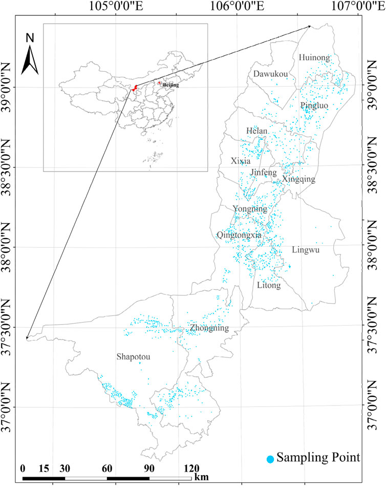
Figure 1. Regional overview.
2.2 Methods
2.2.1 Sample selection
Thirteen districts and counties in Ningxia were selected for this study, covering major land use types, such as watered land, paddy land, and dry land. Sample selection was based on the following principles: (1) samples covered districts or counties with different topographic conditions (plains, hills, and mountains) and topsoil textures (clay, loam, and sand) and (2) samples were evenly distributed within the study area to avoid localized regional bias.
The representativeness of samples was ensured through “stratified random sampling”. Coverage of core habitats in the region: For each region, sampling points were arranged based on its salinization degree (mild, moderate, severe), land use type (cultivated land, grassland, bare land) and microtopography (flat land, depression). A total of 2,543 sampling units were set up, and the “five-point sampling method” was adopted for each unit to collect surface soil (0–20 cm depth). This ensures that the samples cover the main habitat types in the region and avoids representativeness bias caused by a single environment. Guarantee of data stability, Three replicates were taken for each sampling unit to ensure the stability of sample data (Table 1).
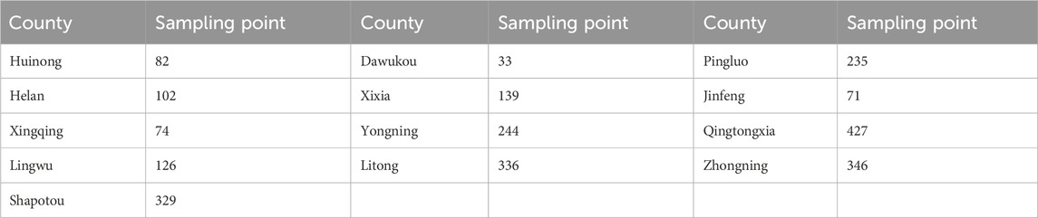
Table 1. Sample collection quantity in each county and district.
2.2.2 Selection of evaluation indicators
The selection of evaluation metrics was based on the following principles (Yu et al., 2024). (1) The indicators should have significant impacts on the quality of cultivated land. (2) The indicators should have sufficient spatial variation within the study area to support classification. (3) The indicators should remain relatively stable over time to ensure that the evaluation results are valid over a long time period. (4) The selection of indicators should account for the scale characteristics of the area. (5) The indicators should be accessible, measurable, comparable, and easily quantified and processed.
This paper follows the principle of combining basic indicators with regional supplementary indicators, and selects the evaluation indicators based on the characteristics of the study area (Gan New District). The Analytic Hierarchy Process (AHP) model and the membership function model are applied to establish the weights and membership functions of each indicator. The combination of the two is suitable for saline-alkali land evaluation: the former determines the weights, while the latter quantifies fuzzy indicators, forming a reliable system that integrates qualitative and quantitative analysis. Geng et al. (2016) and Zhu (2022) clarifies the index for classifying the quality grade of cultivated land, and constructs the evaluation index system for cultivated land quality. The system involved four aspects, soil physiochemical indicators, topography and geomorphology, integrated farmland management measures, and health status, with a total of 15 evaluation factors, as shown in Table 2. The sodium adsorption ratio (SAR) and exchangeable sodium percentage (ESP) are classic indicators for evaluating the degree of soil alkalization. However, the study shows that soil pH is significantly positively correlated with ESP (P < 0.01), and when pH > 8.5, the sodium ion saturation on the surface of soil colloids usually exceeds 15% (the critical value for alkalization). Therefore, pH can be used as a substitute indicator for the degree of alkalization in the study area, and there is no need to repeatedly determine SAR and ESP (Ranjbar and Jalali, 2016). Electrical conductivity (EC) is extremely significantly positively correlated with total salt content (P < 0.01), so EC is also not selected as an indicator for soil quality evaluation (Zeng et al., 2020).
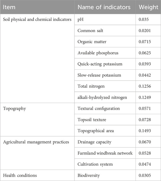
Table 2. The weights of each evaluation indicator in the study area.
2.2.3 Calculation of the integrated fertility index of saline-alkali land
The cumulative method was used to calculate the Integrated Fertility Index (IFI) for soil quality assessment, based on which soil quality grades were determined. The formula was as follows:
where IFI (Integrated Fertility Index) is the quality index of cultivated land; Ci refers to the combination weight of the evaluation index i, and Fi stands for the membership degree of the evaluation index i (Table 3).
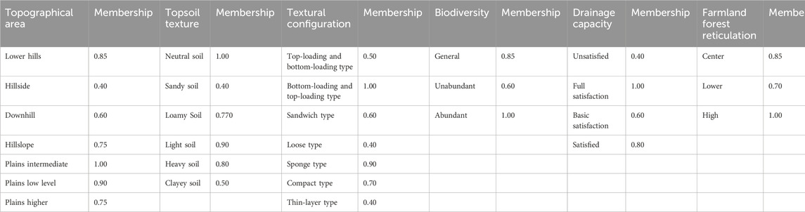
Table 3. Conceptual index membership degree.
Based on the “Indicators of Cultivated Land Quality Grade Classification in Gansu, Xinjiang, and Inner Mongolia” in the national standard of Cultivated Land Quality Grade (GB/T 33,469-2016) (Mara, 2016) and the IFI data obtained from measurements, the dynamic change in saline-alkali land quality in the demonstration area was assessed using an indicator-based comparative analysis (Table 4).

Table 4. Ningxia cultivated land quality comprehensive index IFI classification standard.
2.2.4 Data configuration and data sources
The measured physical indicator of soil quality was bulk density, and the chemical indicators were soil organic matter, total nitrogen, AHN, available phosphorus, available potassium, slowly available potassium, and total salt contents as well as pH. Bulk density was measured using the ring knife method (Gebre, 2018). The organic matter content was determined using the external heating potassium dichromate oxidation method (Lal, 2020). The total nitrogen content was measured using the sulfuric acid digestion–distillation method (Avramidis et al., 2015). The AHN content was determined using the alkali-hydrolysis diffusion method (Drescher et al., 2020). The available phosphorus content was measured using the sodium bicarbonate extraction–molybdenum antimony colorimetric method (Zhang Y. L. et al., 2023). The available potassium content was determined using ammonium acetate extraction followed by flame photometry (Cheng et al., 2025). Soil pH was measured using a pH meter (Hartemink and Barrow, 2023). The water-soluble total salt content was determined using the electrical conductivity method (Lao et al., 2021).
Topographic parameters (slope and texture configuration) were extracted based on 1:10,000 topographic maps and the results of the Second National Soil Survey of China. The degree of farmland shelterbelt development was interpreted using historical imagery from Google Earth (2019) and verified through field surveys. Data on management measures (crop types and crop rotation patterns) were obtained from the Information System of Cultivated Land Resource Management Across Counties of the Ministry of Agriculture and Rural Affairs. Biological diversity (BD) was evaluated through quadrat surveys conducted in 13 districts and counties, targeting arthropod and microbial communities. Based on species richness and evenness, the biological diversity that normalized to [0,1] was estimated using the following equation:
where H is Shannon’s entropy index and S is species richness.
Drainage capacity data were obtained from the 2022 monitoring records of the China Geological Survey, with a precision of 0.5 m. All data were processed through quality control, including repeated measurements (coefficient of variation <5%), consistency checks between remote sensing imagery and ground verification (>90% agreement), and spatial gap-filling using Kriging interpolation. These procedures ensured the accuracy of parameter characterization and the representation of spatial heterogeneity.
The obtained data, including soil physical and chemical indicators, topography and geomorphology, comprehensive farmland management measures, biodiversity, and IFI (Integrated Fertility Index), were imported into ArcGIS 10.8. The attribute table linked with Excel 2021 was created first, followed by the implementation of spatial analysis. All external data were uniformly standardized to a spatial resolution of 30 m × 30 m, and the CGCS 2000_3.000000_Degree_GK_Zone_35 projected coordinate system was adopted for registration and subsequent analysis.
2.2.5 Data processing and analysis
The experimental data were initially organized using Excel 2021 and then processed, analyzed in a statistical framework, and used to generate plots using Origin 2024b. Data are expressed as the mean ± standard error (Mean ± SE). Comparisons among groups were performed using the ANOVA. To investigate the pathways through which different factors affected the quality of saline-alkali soils and the contribution of each factor, we performed a path analysis. To quantify the direct and indirect effects of individual factors and their interactions, the power analysis function of JMP 10.0 was employed. The statistical differences of soil physical and chemical indicators were tested by one-way analysis of variance (ANOVA) using the SPSS 22 software package (SPSS Inc., Chicago, IL, United States). It was found that some data did not conform to the normal distribution; therefore, after transformation with a logarithmic function, all data met the normal distribution requirement.
3 Results and analysis
3.1 Soil physiochemical indicators and their spatial distribution characteristics
Soil physicochemical properties varied significantly among districts and counties (Table 5). Soil pH in the districts and counties ranged from 8.10 to 8.55, with a mean value of 8.33, suggesting that the soils were alkaline. Soil nutrient contents in Huinong District were significantly higher (P < 0.05) than those in other areas, except for the available phosphorus and AHN contents. The available phosphorus content was highest in Jinfeng District and was significantly lower in Dawukou District than in other districts and counties (P < 0.05). The AHN content of Yongning County was 74.36 mg/kg, which was significantly higher than those of other areas; Shapotou District exhibited the lowest AHN content (P < 0.05). In addition, Huinong District had the highest salt accumulation level, while Yongning County demonstrated the lowest degree of salinization.

Table 5. Basic physical and chemical characteristics of soils in the study areas.
Significant differences in the spatial distribution of soil physiochemical properties were detected among districts and counties (Figure 2). Overall, the soil samples in the study area were alkaline (pH 7.73–8.90), and the contents of slowly available potassium, available potassium, organic matter, and total nitrogen were generally higher in the north and lower in the south. In contrast, soil nitrogen contents were higher in the southern areas, particularly in Yongning County (74.36 mg/kg) and Qingtongxia (68.86 mg/kg). Based on the total salt content, soil salinization was more severe in the north. Huinong District (1.42–3.43 g/kg) and Pingluo County (1.06–1.76 g/kg) were the core areas of salinization, while Yongning County (0.30–1.05 g/kg) and Litong District (0.30–1.05 g/kg) had lower salinization risks. In addition, the available phosphorus content in the soils of the study area showed an uneven distribution. In the northern and central regions, areas with low and high available phosphorus contents were interspersed, while in the southern region, large areas with relatively low available phosphorus contents were distributed in a belt-like pattern along the edges of the study area.
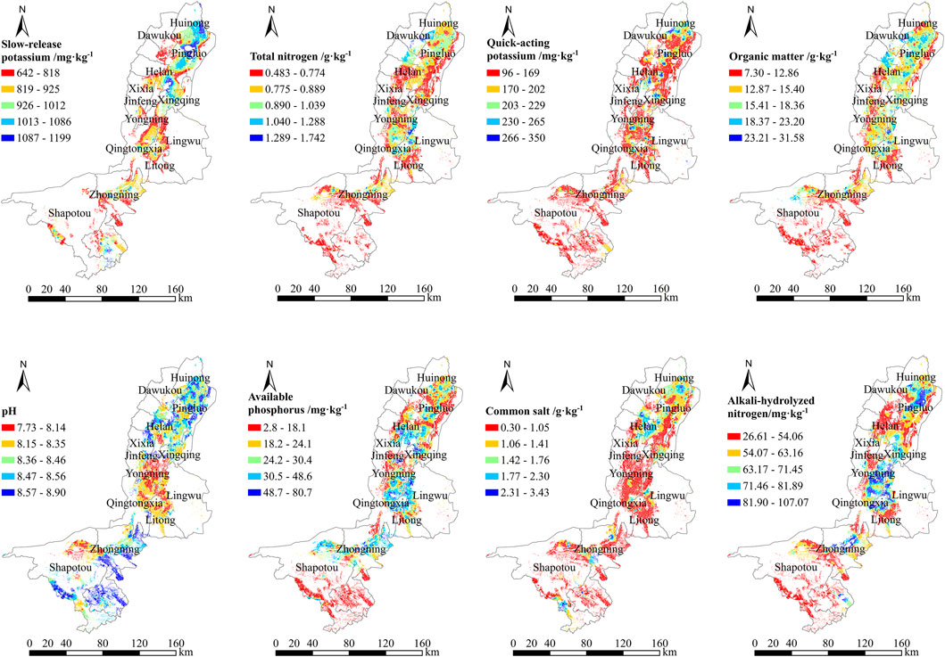
Figure 2. Spatial distribution of soil physical and chemical properties in the study area.
3.2 Environmental factors and their spatial distribution characteristics
3.2.1 Integrated farmland management measures
The overall drainage capacity of the study area was generally adequate. In the northern regions, Huinong District and Pingluo County mainly used open channel drainage systems. The central region exhibited diverse drainage characteristics. In Qingtongxia, drainage capacity was generally adequate. In contrast, Zhongning County in the southern part of the study area displayed a clear north–south gradient in drainage capacity. Overall, the northern area consisted of large contiguous zones with sufficient drainage, the central area formed a transitional belt with generally adequate capacity, and the southern area was dominated by zones with insufficient drainage. Farmland with marginally adequate drainage capacity was sporadically interspersed within these regions. In contrast, areas with high drainage capacity overlapped with zones of low soil salinity in spatial distribution.
The degree of farmland shelterbelt development exhibited a clear spatial pattern, decreasing from south to north. In the northern region, including Huinong District and Pingluo County, shelterbelts were sparse, with fragmentation rates exceeding 50%. In the central region, Lingwu and Qingtongxia had a moderate shelterbelt density, while Xingqing District, Jinfeng District, and Xixia District showed relatively low levels of farmland shelterbelt coverage. Areas with high shelterbelt density were mostly concentrated in zones of intensive agriculture. In the south, Yongning County and Litong District had high shelterbelt coverage, with shelterbelt integrity exceeding 80% and strong spatial continuity. In contrast, Shapotou District exhibited consistently low shelterbelt coverage across its entire area (Figure 3).
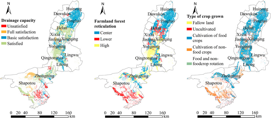
Figure 3. Integrated farmland management in the study area.
Crop types in the study area exhibited a distinct zonal distribution. Huinong and Pingluo Counties in the northern region and Yongning and Litong Counties in the southern region were dominated by grain crop cultivation. In the central part of the study area, Qingtongxia and Lingwu featured large, continuous grain crop cultivation areas, forming a large-scale production belt. Non-grain crops were distributed in sporadic patches. Transitional zones, where grain and non-grain crops are rotated, were interspersed between the primary production zones and appeared as irregular mosaics. Fallow plots within cultivated areas were typically small and scattered, often spatially associated with crop rotation zones. Uncultivated land was distributed in large, contiguous patches along the outer margins of the study area, forming a discontinuous buffer zone.
3.2.2 Biological biodiversity and geomorphology
Biodiversity in the study area was higher in the south than in the north, as presented in Figure 4. In the southern region, the biodiversity index of Shapotou District was 0.94, and abundant vegetation types were observed, covering more than 20 species, such as Medicago sativa, Lycium chinense, and Elaeagnus angustifolia L. In the north, the biodiversity index of Xixia District was 0.71, indicating relatively low plant species richness, with fewer than ten species, dominated by salt-tolerant plants, such as Suaeda glauca and Kalidium foliatum. In the central region, including Qingtongxia (1.00) and Lingwu (0.92), clear transitional characteristics were identified, reflecting a mix of both northern and southern vegetation features. Areas with high biodiversity were highly aligned with areas with low soil salinity and high organic matter contents. As indicated by previous analyses (Figure 2), the soil salinity and organic matter content of the central transitional region were intermediate between those in the northern and southern regions, further affecting biodiversity.

Figure 4. Biological diversity and geomorphology in the study area.
The terrain of the study area was primarily characterized by middle and lower terraces of plains. In the northern region, Huinong District and Pingluo County consisted of contiguous alluvial plains with a flat topography; higher terraces were sporadically distributed in the northernmost part. In the central region, Qingtongxia and Lingwu were dominated by lower and higher plain terraces, with middle terraces forming continuous patches and featuring slight microtopographic undulations. In the southern region, Yongning County and Litong District exhibited an interlaced distribution of lower and middle plain terraces along the lower slopes of hills. The southern margin of Litong District was mainly characterized by mid-slope mountainous terrain, while Shapotou District and Zhongning County were predominantly situated on upper mountain slopes, with a small portion of lower mountain slopes found in the central area. Depressions were concentrated in areas that overlap partially with zones of high soil salinity.
3.2.3 Topsoil texture
In the northern region, Huinong District and Pingluo County exhibited distinct vertical soil texture configurations. In the central region, soils in Qingtongxia and Lingwu predominantly showed a loose configuration, whereas those in Yongning County were primarily sponge-like. In the southern region, Litong District was mainly characterized by a loose configuration, with compact and interbedded configurations appearing sporadically. In Zhongning County and Shapotou District, soil profiles with loose-over-compact, compact-over-loose, and sponge-like configurations were distributed in a belt-like pattern along the periphery of the study area (Figure 5).

Figure 5. The characteristics of saline-alkali soil texture in the study area.
The topsoil texture in the study area was predominantly classified as light loam. In the northern region, heavy loam, sandy loam, and sandy soil were sporadically distributed around the periphery of Huinong District and Pingluo County, while medium loam was distributed in large contiguous patches in the central part. In the central region, sandy soils were distributed in a patchy manner along the margins of Qingtongxia and Lingwu. In the southern region, sandy soils formed belt-like patterns in Yongning County and Litong District, whereas medium loam soils in Zhongning County were scattered sporadically. Clay loam areas were concentrated in regions of irrigated agriculture, while sandy loam areas largely overlapped with zones of wind erosion and desertification.
3.3 Soil quality in saline-alkali land
3.3.1 Spatial distribution of saline-alkali soil quality
The saline-alkali soils in the study area exhibited a distributional pattern characterized by a higher quality in the north than in the south (Figure 6). In the northern region, Huinong District (Grade 2), Pingluo County (Grade 3), and Xixia District (Grade 4) formed a high-quality core area. In the central region, Qingtongxia (Grade 6) and Lingwu (Grade 7) demonstrated a moderate quality. In the southern region, Yongning County (Grade 8), Litong District (Grade 9), and Shapotou District (Grade 10) showed abundant low-quality areas. These low-quality areas (≥Grade 8) were mainly distributed in the lower reaches of the Yellow River alluvial plain and aeolian sand-affected zones. These areas coincided spatially with regions identified as high-risk for salinization, where total soil salinity exceeds 1.0 g/kg. High-quality areas were concentrated in the irrigated agricultural areas in the north, while low-quality areas extended in a strip-like pattern along the southern bank of the Yellow River and the edge of deserts. There were significant differences in quality among counties and evident transitions between adjacent areas. For example, variation in quality levels was identified at the border between Pingluo County (Grade 3) and Helan County (Grade 5).
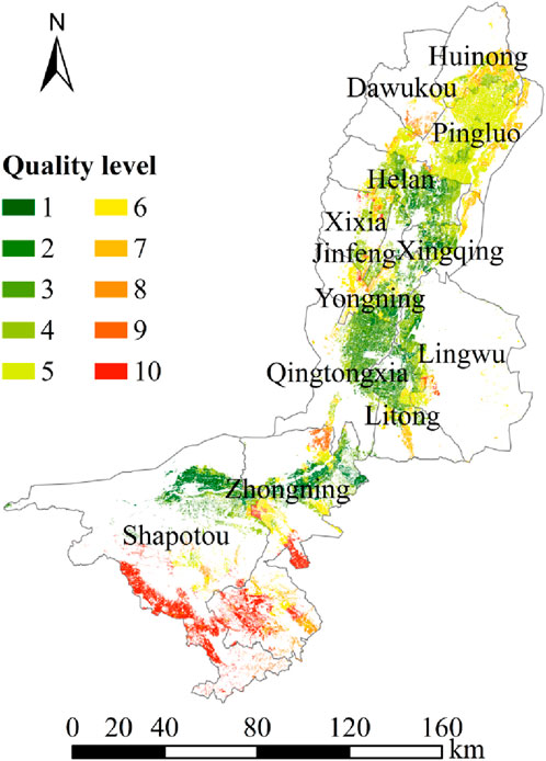
Figure 6. Distribution of soil quality grades in the saline-alkali area of the study area.
3.3.2 Identification of factors influencing the quality of saline-alkali land
The relative contributions of individual factors on the quality grade of saline-alkali land were ranked as follows: AHN > topsoil texture > pH > drainage capacity. These findings indicated that AHN is the dominant factor, with the most significant direct effect on quality. The direct path coefficient for AHN reached −0.514, demonstrating a strong negative correlation (Table 6).
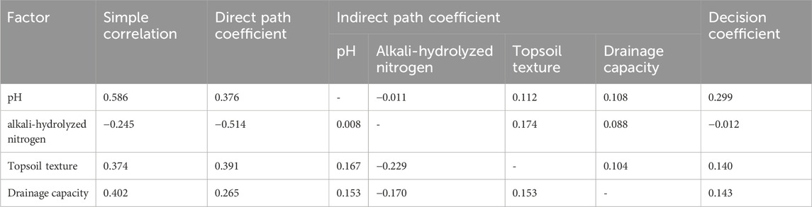
Table 6. Pathway analysis of saline soil quality and key influencing factors.
Drainage capacity had a weaker direct effect on the dependent variable, with a direct path coefficient of 0.265. The ranking of the absolute values of the summed indirect path coefficients revealed the relative magnitude of indirect effects of various factors. Topsoil texture exhibited the strongest indirect effect. It exerted effects on the dependent variable mainly through its association with factors such as drainage capacity. In contract, AHN had the weakest indirect effect.
In the ranking of the absolute values of the determination coefficients, soil pH exhibited the strongest overall determinative power on the dependent variable (0.299), functioning as a promoting factor. This was followed by drainage capacity (0.143), with topsoil texture (0.140) showing a comparable but slightly weaker effect. AHN demonstrated the weakest overall determinative power and acted as an inhibitory factor.
According to JMP calculations (Figure 7), the factors differed in the contribution to the quality of saline-alkali land. Soil pH, AHN, topsoil texture, and drainage capacity were the core influencing factors. The sum of the individual factor contributions of these factors was 75.12%, with their contributions ranking as follows: topsoil texture (20.47%) > drainage capacity (20.28%) > AH/N (20.02%) > pH (14.35%). Two-factor interactions contributed 17.05%, with the interaction between pH and AHN (4.84%) being the most prominent.

Figure 7. The interaction relationship of different key influencing factors on the quality of saline-alkali land.
4 Discussion
The salinity and nutrient contents in saline-alkali land in the Ningxia section of the Yellow River Basin showed a spatial distribution characterized by higher levels in the north and lower levels in the south. This pattern was closely related to regional differences in topography, drainage capacity, and measures to improve saline-alkali land. It is a result of a combination of natural conditions and human interventions. The results of path analysis showed that soil pH value, available nitrogen (AN), topsoil texture, and drainage capacity were the main influencing factors, among which the single-factor contribution of available nitrogen, topsoil texture, and drainage capacity to salinization all exceeded 20%. Saline-alkali soils usually have the problem of nitrogen deficiency. In some experimental areas, the application of additional nitrogen fertilizer has effectively increased the available nitrogen content in saline-alkali soils and alleviated the degree of salinization (Hou et al., 2025). However, soil textures with high porosity and strong permeability are characterized by poor fertilizer retention, which affects the immobilization of nutrients and leads to an increase in the degree of salinization (Cox et al., 2018). Meanwhile, Topsoil texture influences soil structure and regulates salt migration; clayey soils exacerbate surface salt accumulation through capillary action, whereas sandy soils enhance permeability and thus promote salt leaching. In the clay area, ' mixed sand + organic fertilizer ' or ' soil structure conditioner ' can be used to reduce the cementation between clay particles, form aggregates, enhance the efficiency of drainage and salt washing, and indirectly alleviate the inhibition of salt on soil quality (Grunwald et al., 2016). The light soil area should focus on maintaining the aggregate structure through ' rotation fallow + straw mulching ', avoiding clay accumulation or organic matter consumption caused by long-term continuous cropping (Li et al., 2025). Drainage capacity exerts critical control over the groundwater table, particularly in low-lying areas. Inadequate drainage causes salts to rise into the topsoil via capillary water. The quality of saline-alkali soils is regulated by the coupling effect of soil pH and nutrients. Alkaline environments immobilize soil nitrogen, reducing the availability of alkali-hydrolyzable nitrogen (AHN). The contribution of higher-order interactions among these four factors is relatively low, indicating that the salinization-alkalization process may be driven by the systematic interactions of soil pH, nutrients, texture, and drainage. For instance, under alkaline conditions, insufficient drainage exacerbates the retention of sodium ions, while loose topsoil texture may alleviate salt accumulation by accelerating leaching. Therefore, the quality of saline-alkali soils is not determined by individual factors. Instead, it is the result of multi-level effects: fundamental factors such as pH function by directly regulating the balance of base ions, while higher-order interactions amplify or inhibit the salinization-alkalization process through non-linear effects.
In the remediation of salinized soils, the resilience of soil ecosystems is one of the indicators that cannot be ignored. Relevant studies have shown that comprehensive farmland management measures and biodiversity are key factors influencing the resilience of soil ecosystems (Lukac, 2017). Factors such as farmland drainage measures and tillage methods can effectively affect the abundance of biodiversity. The study found that The similarity between the spatial distributions of biodiversity, soil organic matter, and salinity suggests that environments with high organic matter contents and low salinity provide suitable habitats for diverse vegetation (Coverdale and Davies, 2023). Alternatively, low diversity zones dominated by salt-tolerant plants in the north reflected the limiting effect of salinity-alkalinity stress on the ecosystem (Yang et al., 2022). Meanwhile, the positive impact of reasonable farmland management measures on biodiversity is not only reflected in the richness of aboveground plants. The reduction in salinization provides a favorable environment for the propagation of microbial communities; in turn, the increase in microbial abundance can effectively enhance the stability of soil aggregates and improve the soil environment (Chen et al., 2021). This synergistic model between “management measures” and “biodiversity” transforms the originally fragile soil ecosystem—once dependent on external inputs—into a sound and positive cycle. Therefore, reasonable comprehensive farmland management measures and biodiversity can also effectively alleviate the degree of soil salinization.
Existing zonal management measures are closely aligned with regional characteristics; however, their long-term effects and the interactions among different measures need to be monitored continuously. In the northern open-channel drainage area (Huinong District), the promotion of a combined approach using biochar-based soil amendments and drip irrigation is recommended to overcome the permeability limitations of clay soils (Yuan et al., 2025). Among them, the biochar used is the product of low-temperature pyrolysis of corn stover. It is applied as a base fertilizer before tillage in late autumn and early winter, and an integrated operation of “mechanical deep plowing + rotary tillage” is adopted to uniformly mix the amendment into the 0–30 cm plow layer.) In the central irrigation area (Qingtongxia), it is essential to integrate salt-blocking shelterbelts (with shelterbelt coverage exceeding 60%) and drainage-based salt control measures to interrupt the combined processes of wind erosion and salt migration (Zhao et al., 2015). A dense structure (canopy density 0.7–0.8) is adopted for the backbone forest belts on the periphery of oases, where Populus euphratica and Elaeagnus angustifolia are planted to block external wind-blown sand. Alfalfa (Medicago sativa) is intercropped between the forest trees to form a “forest-grass” composite system. The nitrogen fixation by alfalfa roots can increase soil organic matter content.) In the southern sandy region (Shapotou District), establishing a joint monitoring network for sand-fixing vegetation and soil microorganisms is advised to evaluate the potential impact of salt-tolerant plants on groundwater dynamics (Wang and Li, 2023). A response model of “vegetation growth status - microbial activity - groundwater depth” was constructed based on monitoring data. When the groundwater depth in the Salix psammophila area drops below 5 m, supplementary irrigation should be conducted; when the abundance of nitrogen-metabolizing microbial communities in the Caragana korshinskii area decreases by more than 20%, organic fertilizers should be topdressed to activate microorganisms. In addition, the use of saline-alkali land in urban-rural interfaces during the process of urbanization and the optimization of crop rotation systems in the agro-pastoral ecotone should be a focus of future research. This study shares consensus with international research that salinization is co-driven by natural and human interventions, and that drainage is a key factor. However, differences exist in the weight of driving factors, improvement technologies, and the depth of ecological regulation. In the future, international experience can be drawn upon to upgrade remote sensing and modeling technologies and deepen research on microorganisms.
5 Conclusion
This study revealed that the salinity and nutrient contents in the saline-alkali soils of the Ningxia section of the Yellow River Basin exhibit a spatial pattern of “higher in the north and lower in the south”, a pattern shaped by the combined effects of natural conditions (e.g., topographic variations, drainage capacity) and human interventions (e.g., saline-alkali soil improvement measures). Path analysis indicated that soil pH, alkali-hydrolyzable nitrogen (AHN), topsoil texture, and drainage capacity are the core factors driving the quality of saline-alkali soils, and their systematic interactions dominate the salinization-alkalization process (with relatively low contribution from higher-order interactions). Specifically, topsoil texture has the most significant direct contribution, as it affects salt migration by regulating soil structure (clayey soils tend to accumulate salt, while sandy soils promote leaching). Drainage capacity contributes 20.28% and restricts the capillary rise of salts by controlling the groundwater table, especially in low-lying areas. There is a coupling effect between pH and nutrients: alkaline environments immobilize soil nitrogen and reduce the availability of AHN. Additionally, the synergy between comprehensive farmland management measures and biodiversity can enhance the resilience of soil ecosystems, creating a positive cycle of “salinization-alkalization alleviation - soil quality improvement” by increasing the richness of aboveground plants and the abundance of underground microorganisms.
In practice, zone-specific measures are required: in the northern Huinong District, the “corn stover low-temperature pyrolysis biochar + drip irrigation” approach is promoted, with the mixture deeply plowed into the 0–30 cm plow layer; in central Qingtongxia, a system integrating “Populus euphratica-Elaeagnus angustifolia shelterbelts (canopy density 0.7–0.8) + Medicago sativa intercropping + drainage” is constructed; in southern Shapotou District, a “vegetation-microorganism” monitoring network is established for dynamic management based on groundwater depth and microbial abundance. Future research should continuously monitor the long-term effects of these measures, expand studies on the utilization of saline-alkali soils in urban-rural interfaces/agro-pastoral ecotones, deepen the understanding of microbial functional mechanisms, and improve the multi-factor coupling quantitative model.
Data availability statement
The original contributions presented in the study are included in the article/supplementary material, further inquiries can be directed to the corresponding author.
Author contributions
WWe: Project administration, Writing – original draft. QX: Conceptualization, Writing – review and editing, Writing – original draft. YB: Writing – review and editing, Methodology. WeW: Writing – review and editing, Formal Analysis. HW: Conceptualization, Writing – review and editing. WY: Investigation, Writing – review and editing, Software. YL: Validation, Data curation, Writing – review and editing, Formal Analysis. KW: Writing – review and editing. DW: Formal Analysis, Writing – review and editing. YZ: Writing – review and editing. XG: Formal Analysis, Writing – review and editing.
Funding
The author(s) declare that financial support was received for the research and/or publication of this article. This research was funded by the National Key Research and Development Program of China (No. 2021YFD1900600).
Conflict of interest
The authors declare that the research was conducted in the absence of any commercial or financial relationships that could be construed as a potential conflict of interest.
Generative AI statement
The author(s) declare that no Generative AI was used in the creation of this manuscript.
Any alternative text (alt text) provided alongside figures in this article has been generated by Frontiers with the support of artificial intelligence and reasonable efforts have been made to ensure accuracy, including review by the authors wherever possible. If you identify any issues, please contact us.
Publisher’s note
All claims expressed in this article are solely those of the authors and do not necessarily represent those of their affiliated organizations, or those of the publisher, the editors and the reviewers. Any product that may be evaluated in this article, or claim that may be made by its manufacturer, is not guaranteed or endorsed by the publisher.
References
Avramidis, P., Nikolaou, K., and Bekiari, V. (2015). Total organic carbon and total nitrogen in sediments and soils: a comparison of the wet oxidation–titration method with the combustion-infrared method. Agric. Agric. Sci. Procedia 4, 425–430. doi:10.1016/j.aaspro.2015.03.048
Chen, Y., Li, S., Liu, N., He, H., Cao, X., Lv, C., et al. (2021). Effects of different types of microbial inoculants on available nitrogen and phosphorus, soil microbial community, and wheat growth in high-P soil. Environ. Sci. Pollut. Res. 28, 23036–23047. doi:10.1007/s11356-020-12203-y
Cheng, J., Chen, D., Chen, X., Mao, Y., Li, A., Zhu, K., et al. (2025). Divergent responses of cropland soil available potassium to fertilization across the Sichuan basin of China. Soil Tillage Res. 253, 106654. doi:10.1016/j.still.2025.106654
Coverdale, T. C., and Davies, A. B. (2023). Unravelling the relationship between plant diversity and vegetation structural complexity: a review and theoretical framework. J. Ecol. 111 (7), 1378–1395. doi:10.1111/1365-2745.14068
Cox, C., Jin, L., Ganjegunte, G., Borrok, D., Lougheed, V., and Ma, L. (2018). Soil quality changes due to flood irrigation in agricultural fields along the rio grande in Western Texas. Appl. Geochem. 90, 87–100. doi:10.1016/j.apgeochem.2017.12.019
Drescher, G. L., Da silva, L. S., Sarfaraz, Q., Molin, G. D., Marzari, L. B., Lopes, A. F., et al. (2020). Alkaline hydrolyzable nitrogen and properties that dictate its distribution in paddy soil profiles. Pedosphere 30, 326–335. doi:10.1016/s1002-0160(20)60012-1
Feng, L., Luo, G., Ioppolo, G., Zhang, X., and Liao, W. (2025). Prevention and control of soil pollution toward sustainable agricultural land use in China: analysis from legislative and judicial perspectives. Land Use Policy 151, 107497. doi:10.1016/j.landusepol.2025.107497
Gebre, A. B. (2018). Comparison of bulk density methods in determining soil organic carbon storage under different land use types. J. Soil Sci. Environ. Manag. 9 (1), 13–20. doi:10.5897/jssem2017.0664
Geng, Y., Jiang, T., and Zhang, X. (2016). “Research on FSV in membership function credibility verification — for system performance evaluation,” in 2016 Progress in Electromagnetic Research Symposium (PIERS), Shanghai, China, 08-11 August 2016 (IEEE), 4723–4727.
Grunwald, D., Kaiser, M., and Ludwig, B. (2016). Effect of biochar and organic fertilizers on C mineralization and macro-aggregate dynamics under different incubation temperatures. Soil Tillage Res. Curr. future Challenges Biochar Res. 164, 11–17. doi:10.1016/j.still.2016.01.002
Hartemink, A. E., and Barrow, N. J. (2023). Soil pH-nutrient relationships: the diagram. Plant Soil 486 (1), 209–215. doi:10.1007/s11104-022-05861-z
Hou, P., Li, B., Cao, E., Jian, S., Liu, Z., Li, Y., et al. (2025). Optimizing maize yield and mitigating salinization in the yellow river Delta through organic fertilizer substitution for chemical fertilizers. Soil Tillage Res. 249, 106498. doi:10.1016/j.still.2025.106498
Lal, R. (2020). Soil organic matter content and crop yield. J. Soil Water Conservation 75 (2), 27A–32A. doi:10.2489/jswc.75.2.27a
Lao, C., Chen, J., Zhang, Z., Chen, Y., Ma, Y., Chen, H., et al. (2021). Predicting the contents of soil salt and major water-soluble ions with fractional-order derivative spectral indices and variable selection. Comput. Electron. Agric. 182, 106031. doi:10.1016/j.compag.2021.106031
Li, H., Zhao, Q., and Huang, H. (2019). Current states and challenges of salt-affected soil remediation by cyanobacteria. Sci. Total Environ. 669, 258–272. doi:10.1016/j.scitotenv.2019.03.104
Li, R., Li, Y., Wan, Y., Zhang, X., Zhou, Q., and Li, T. (2025). Regulation of organic matter consumption, nitrification, and iron reduction using magnetite nanoparticles in paddy soil: implications for anaerobic carbon sequestration. Chem. Eng. J. 507, 160478. doi:10.1016/j.cej.2025.160478
Liu, L., Wu, Y., Yin, M., Ma, X., Yu, X., Guo, X., et al. (2023). Soil salinity, not plant genotype or geographical distance, shapes soil microbial community of a reed wetland at a fine scale in the Yellow River Delta. Sci. Total Environ. 856, 159136. doi:10.1016/j.scitotenv.2022.159136
Lukac, M. (2017). “Introduction: the role of soil biodiversity in ecosystem productivity and resilience,” in Soil biological communities and ecosystem resilience (Cham: Springer International Publishing), 1–7.
MARA (2016). Minsitry of agriculture and rural affairs of the people’s Republic of China (MARA) cultivated land quality grade.
Ögmundarson, Ó., Herrgård, M. J., Forster, J., Hauschild, M. Z., and Fantke, P. (2020). Addressing environmental sustainability of biochemicals. Nat. Sustain. 3, 167–174. doi:10.1038/s41893-019-0442-8
Ranjbar, F., and Jalali, M. (2016). The combination of geostatistics and geochemical simulation for the site-specific management of soil salinity and sodicity. Comput. Electron. Agric. 121, 301–312. doi:10.1016/j.compag.2015.12.010
Wang, L., and Li, X. (2023). Soil microbial community and their relationship with soil properties across various landscapes in the Mu us desert. Forests 14, 2152. doi:10.3390/f14112152
Wang, H., Huang, S., Di, D., Wang, Y., and Zhang, F. (2021). Study on the spatial distribution of water resource value in the agricultural system of the Yellow River Basin. Water Policy 23 (4), 1044–1058. doi:10.2166/wp.2021.176
Wang, X., Zhu, H., Hou, S., Cui, H., and Yan, B. (2024). Environmental impacts of fertilization during rice production in saline-alkali paddy fields based on life cycle assessment. J. Clean. Prod. 467, 142947. doi:10.1016/j.jclepro.2024.142947
Wu, J., Li, P., Qian, H., and Fang, Y. (2014). Assessment of soil salinization based on a low-cost method and its influencing factors in a semi-arid agricultural area, northwest China. Environ. Earth Sci71 71, 3465–3475. doi:10.1007/s12665-013-2736-x
Wu, Z. S., Li, Y., Wang, R., Xu, X., Ren, D. Y., Huang, Q. Z., et al. (2023). Evaluation of irrigation water saving and salinity control practices of maize and sunflower in the upper Yellow River basin with an agro-hydrological model based method. Agric. Water Manag. 278, 108157. doi:10.1016/j.agwat.2023.108157
Yang, D., Tang, L., Cui, Y., Chen, J., Liu, L., and Guo, C. (2022). Saline-alkali stress reduces soil bacterial community diversity and soil enzyme activities. Ecotoxicology 31 (9), 1356–1368. doi:10.1007/s10646-022-02595-7
Yu, Z., Kuang, L., Jiang, Y., Li, W., Zhang, J., Zhou, Y., et al. (2024). Soil attributes are more important than others in shaping the diversity of cultivated land quality types, southern China. Ecol. Indic. 166, 112472. doi:10.1016/j.ecolind.2024.112472
Yuan, X., Ban, G., Luo, Y., Wang, J., Peng, D., Liang, R., et al. (2025). Biochar effects on aggregation and carbon-nitrogen retention in different-sized aggregates of clay and loam soils: a meta-analysis. Soil Tillage Res. 247, 106365. doi:10.1016/j.still.2024.106365
Zeng, Y., Zhao, C., Kundzewicz, Z. W., and Lv, G. (2020). Distribution pattern of Tugai forests species diversity and their relationship to environmental factors in an arid area of China. PLOS ONE 15, e0232907. doi:10.1371/journal.pone.0232907
Zhang, J., Ding, Q., Wang, Y., He, M., and Jia, K. (2023). Soil quality assessment and constraint diagnosis of salinized farmland in the Yellow River irrigation area in northwestern China. Geoderma Reg. 34, e00684. doi:10.1016/j.geodrs.2023.e00684
Zhang, Y. L., Yang, L., Sun, W., Ruan, Y., Dou, H., Song, M., et al. (2023). An effective method of magnetic field treatment in increasing soil phosphorus availability in wheat rhizosphere. Rhizosphere 27, 100760. doi:10.1016/j.rhisph.2023.100760
Zhao, X., Xu, H., Zhang, P., Bai, Y., and Zhang, Q. (2015). Impact of changing irrigation patterns on saltwater dynamics of soil in farmlands and their shelterbelts in the irrigated Zone of kalamiji oasis. Irrig. Drain. 64, 393–399. doi:10.1002/ird.1708
Keywords: soil quality of saline-alkali land, spatial distribution characteristics, influencing factors, topsoil texture, northwest China
Citation: Wei W, Xiao Q, Bai Y, Wang W, Wang H, Yang W, Liu Y, Wu K, Wu D, Zhao Y and Gong X (2025) Soil quality and its determinants in saline-alkali land of northwest China. Front. Environ. Sci. 13:1687358. doi: 10.3389/fenvs.2025.1687358
Received: 19 August 2025; Accepted: 30 October 2025;
Published: 11 November 2025.
Edited by:
Xiaomei Yang, Wageningen University and Research, NetherlandsReviewed by:
Mohamed Gad, University of Sadat City, EgyptYuting Cheng, Xi’an Technological University, China
Copyright © 2025 Wei, Xiao, Bai, Wang, Wang, Yang, Liu, Wu, Wu, Zhao and Gong. This is an open-access article distributed under the terms of the Creative Commons Attribution License (CC BY). The use, distribution or reproduction in other forums is permitted, provided the original author(s) and the copyright owner(s) are credited and that the original publication in this journal is cited, in accordance with accepted academic practice. No use, distribution or reproduction is permitted which does not comply with these terms.
*Correspondence: Qinghong Xiao, eGlhb3Fpbmdob25nNzYwMUAxNjMuY29t