 Kexin Zhou
 Shaojun Chen
 Bing Liang
- National Research Center for Resettlement, Hohai University, Nanjing, China
Large-scale infrastructure projects often cause population displacement, creating challenges for land adaptation and socioeconomic integration in resettlement areas. This study examines Z Town, a reservoir-induced urbanized resettlement site in central China, using an improved Pressure–State–Response (PSR) framework to construct a multidimensional evaluation system. Results show that land use intensity (0.262) lags behind socioeconomic development (0.335), with institutional inertia and mismatches between land functions and residents’ needs as key barriers to coordination. This study contributes in two ways: 1) extending the PSR framework to resettlement research and providing a replicable tool for assessing land–society coupling; and 2) identifying land carrying capacity, resident satisfaction, and land allocation efficiency as critical constraints, offering practical entry points for policy. While based on a single case, the approach and findings are broadly applicable to dam resettlement, mining relocation, and ecological migration, underscoring the need to align land restructuring with human-centered development for sustainable and inclusive growth.
1 Introduction
With the continuous growth of the global population and the expansion of the world economy, the limited availability of land resources has become a critical constraint on sustainable development. The contradiction between the ever-increasing demand for land and its finite supply is becoming increasingly pronounced (Rulian and Hongyi, 2020). In response to this challenge, most developed countries—such as the United States, European nations, and Japan—have adopted intensive land-use strategies to balance economic growth with resource conservation. However, China’s model of intensive land use developed during its rapid urbanization process has gradually exposed a series of economic and social problems (Peng et al., 2014). Specifically, some regions have experienced disorderly urban expansion, low land-use efficiency (Xiong et al., 2021), and inadequate protection of farmers’ rights during land expropriation, which has resulted in frequent land disputes and social conflicts (Peng et al., 2014). Therefore, the rational development and scientific management of land resources have become essential for promoting high-quality and sustainable development.
Land-use issues become even more complex in the context of large-scale population displacement and land reallocation triggered by major reservoir construction projects. The way land is used in reservoir resettlement areas not only reshapes local socioeconomic structures but also exerts long-term and far-reaching impacts on regional ecological environments (Shaojun et al., 2022). Against this backdrop, exploring coordinated development pathways for intensive land use in resettlement areas is of great theoretical and practical importance for promoting sustainable development in these special regions (Zhi et al., 2017).
From a systemic perspective, land use represents a typical coupled “nature–society–economy” system (Zhang et al., 2005). Within this system, the concept of intensive land use has emerged as a strategic response to the scarcity of territorial space. It emphasizes maintaining a dynamic balance among population, resources, and the environment, as well as achieving synergy across economic, social, and ecological benefits. By controlling development intensity, optimizing spatial structures, and adjusting industrial layouts, intensive land use can drive regional industrial restructuring and promote the transformation of development models. From a supply-side perspective, intensive land use not only facilitates resource integration and factor reallocation but also supports regional green transformation and high-quality development (Jiang and Zhou, 2024).
Reservoir resettlement areas typically face severe constraints on land resources. Under limited construction land quotas, how to balance the multiple demands of resettlement, livelihood, and infrastructure development while ensuring the efficient and sustainable use of land has become an urgent challenge (Weixiang et al., 2021; Kexin et al., 2023). This issue is particularly pronounced for “landless resettlers,” who experience a fundamental shift in livelihood after relocating from rural to urban areas. For these groups, land allocation and spatial planning become even more complex, requiring systematic and integrated responses within the broader framework of national territorial spatial optimization.
Existing studies on intensive land use can generally be divided into four major categories: 1) conceptual and theoretical discussions on the connotation and fundamental principles of land-use intensification (Sun et al., 2015; Hui et al., 2015); 2) evaluation studies of intensive land use at different spatial scales and for different land-use types (Yin et al., 2020; Zhang Y. et al., 2020); 3) analyses of influencing factors using diverse methodological approaches (Zhang P. et al., 2020; Gao et al., 2024); and 4) explorations of land-use intensification models, policy assessments, and optimization strategies (Yang et al., 2018; Chao et al., 2024). In the context of resettlement areas, although previous research has identified systemic issues such as land-use functional mismatch and institutional inertia, there remains a lack of an integrated analytical framework capable of quantifying their socioeconomic consequences and elucidating the underlying mechanisms (Gui et al., 2023; Siabi et al., 2025). In recent years, advances in the fields of smart cities and healthy cities have provided new perspectives to address these gaps. Growing evidence indicates that land-use patterns—such as the spatial configuration of blue–green infrastructure and the degree of functional mix—significantly affect residents’ mental health and subjective wellbeing, underscoring the crucial role of health-oriented planning in enhancing community sustainability (Chi and Mak, 2021). Against this backdrop, the adoption of emerging technologies such as big data analytics and artificial intelligence has further expanded research paradigms (Hammad et al., 2019; Wu et al., 2023). By integrating urban data streams—such as street-view imagery and social media data—researchers are now able to quantitatively identify the associations between the built environment and residents’ psychological wellbeing, thereby offering new pathways to understand the complex interactions within the “land–society” system (Shao and Min, 2025). Meanwhile, the rise of systematic theoretical frameworks such as neuroarchitecture and healthy urban design is driving the gradual incorporation of social wellbeing objectives—including mental health and livability—into standardized territorial spatial planning processes (Kalantari et al., 2019; Zhang et al., 2024a).
Three key gaps remain. First, there is no robust framework to quantitatively capture coordination between land-use transformation and socioeconomic adaptation, with much existing work limited to descriptive or macro-level analyses (Pan Y. et al., 2024). Second, indicators for multidimensional coordination in non-agricultural contexts are underdeveloped (Wang et al., 2023a). Third, institutional and governance dynamics—such as inertia, policy lag, and land-function mismatches—are often overlooked despite their role in driving spatial–social asynchrony (Qiao et al., 2023; Kou et al., 2024).
This study makes three main contributions. First, it develops a modified Pressure–State–Response (PSR) framework tailored to landless resettlement areas, providing a more systematic tool for evaluating land–society coordination. Second, through an empirical study of Z Town, a representative urbanized resettlement site in central China, it illustrates the interactive relationship between land-use transformation and socioeconomic development in the context of involuntary urban resettlement. Third, it identifies institutional inertia and land–livelihood mismatches as critical barriers to coordinated development. In the context of resettlement areas, coupling and coordination refers to the dynamic interactions between land systems and socio-economic systems, reflected in a synergistic co-evolutionary process whereby the optimization of land-use structures and socio-economic development mutually reinforce each other. By explicitly delineating these interactions, this concept provides a theoretical foundation for understanding how land-use transformations and socio-economic development progress in a coordinated manner within resettlement areas. Overall, the study not only deepens understanding of this distinctive resettlement paradigm but also proposes a transferable analytical framework with relevance to dam-induced resettlement, mining relocation, and ecological migration, thereby contributing new insights to global debates on sustainable urban transformation (Peng et al., 2021; Peng et al., 2022).
2 Analytical framework
2.1 Construction of intensive land use evaluation systems
Land intensive utilization refers to the process of maximizing the economic, social, and ecological benefits per unit of land area under limited land resources through optimized spatial configuration, enhanced resource-use efficiency, and sustainable management practices (Zhi et al., 2017). Its core objective is to improve the comprehensive carrying capacity and productivity of land within constrained spatial conditions, thereby promoting efficient and sustainable land use. Specifically, urban land intensive utilization primarily concerns the built-up areas of cities, aiming to accommodate larger populations and economic activities within limited land resources. This is achieved by promoting compact urban development, increasing land-use efficiency, and enhancing the density of public services, thus mitigating the encroachment of uncontrolled urban expansion on farmland and ecological spaces (Zhao et al., 2025). In contrast, rural land intensive utilization focuses on rural territories and emphasizes the coordinated allocation of agricultural production, ecological protection, and rural construction land. Key approaches include farmland consolidation, the reutilization of idle homesteads, and agricultural modernization. These measures help to enhance both the scale and spatial efficiency of agricultural production, improve rural living environments, promote sustainable agricultural development, and safeguard national food and ecological security (Sun and Qin, 2021). Meanwhile, resettlement-area land intensive utilization represents a specific category of planning and practice that applies to concentrated residential areas formed through engineering projects, ecological migration, or urban renewal. Its core concern lies in achieving an optimized land-use structure and spatial layout under the dual goals of livelihood reconstruction and ecological protection, ensuring the integrated development of production, living, and ecological spaces. Unlike ordinary urban or rural areas, land intensive utilization in resettlement zones places greater emphasis on achieving a coordinated balance among social, environmental, and land-use efficiency within limited resettlement land resources. This approach seeks to prevent the emergence of inefficient, isolated residential enclaves and to promote sustainable and integrated development within resettlement areas.
Therefore, this article combines the characteristics of the reservoir resettlement land and the special geographical factors of the town resettlement area, from the three levels of pressure, status and response, with the goal of accurately measuring the land use level in the resettlement area (Cheng et al., 2022). The PSR structure model was proposed by the Economic Cooperation and Development Organization (OECD) and the United Nations Environmental Planning Department (UNWP) as a data analysis model for use in evaluating the impact of human activities on the ecological environment and the socioeconomic activities that occur in response (Haoxuan, 2017). The PSR model includes three subsystems: P for pressure, S for state, and R for response. Today, the PSR model has become one of the most commonly adopted and scientific research methods in the field of land resource utilization (Yu et al., 2023; Pan H. H. et al., 2024).
The pressure indicators are used to measure the pressure caused by intensive land use in the resettlement area, such as the resettlement housing floor area ratio, and building density, and includes a total of four indicators (Kexin et al., 2023). State indicators are used to measure the current status of and changes in land use, such as the land use structure diversity index and the proportion of residential land to total construction land, and include a total of four indicators (Cheng et al., 2022). Response indicators are used to measure the implementation status of relevant policies and measures, such as participation in resettlement area planning and migrants’ satisfaction with life in the resettlement area, and include a total of three indicators (Haoxuan, 2017). The specific indicators are shown in Table 1 below:
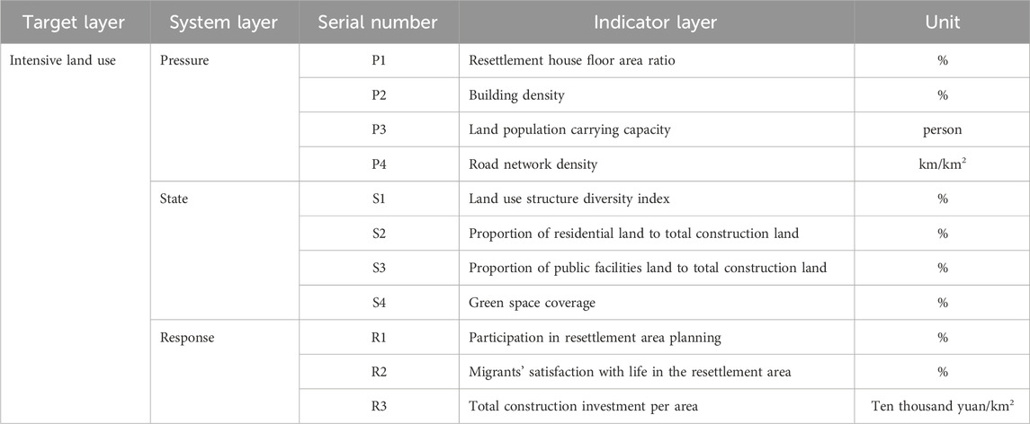
Table 1. Intensive land use indicators.
2.2 Construction of the socioeconomic development system
This study integrates the socioeconomic development characteristics of reservoir resettlement areas with the objective of accurately evaluating development levels across both economic and population dimensions (Deng and Song, 2025). The population subsystem serves as the foundation of socioeconomic development in resettlement areas, encompassing key demographic features such as population size, density, and structure. In contrast, the economic subsystem functions as the core driving force of development, reflecting not only the region’s overall strength in resource endowment and capital accumulation but also the livelihood quality and economic vitality of migrant communities (Li T. et al., 2024). These two subsystems are interrelated and mutually reinforcing, together constituting the essential dimensions for assessing socioeconomic development. Accordingly, this study constructs an indicator system for evaluating the socioeconomic development level of the W Reservoir resettlement area (Z Town), taking both economic and population subsystems into account (Bian et al., 2024).
A total of eight measurable, accessible, and representative indicators were selected, including five economic and three population indicators. Within the economic subsystem, in addition to the core indicator of per capita income of migrants (E1), two other indicators—power supply capacity (E2) and commercial sales per unit area (E3)—were incorporated. The former represents a fundamental input for economic activity and modern living quality, serving as an enabling condition and leading indicator of regional development. The latter directly measures the density and efficiency of commercial activities, reflecting the vibrancy of local consumption markets and the capacity to generate non-agricultural employment opportunities. Together, these indicators capture how the level of economic development translates into improved livelihood outcomes for migrants through both infrastructural support and market dynamism. Within the population subsystem, indicators such as the proportion of the working-age population (P2) and the share of employment in the tertiary sector (P3) further capture the structure and quality of the migrant labor force, revealing its potential for transition toward higher value-added sectors—an essential factor for sustaining livelihoods in the long term (Chen X. et al., 2023). Based on this conceptual logic, eight measurable and representative indicators were ultimately selected, as presented in Table 2.
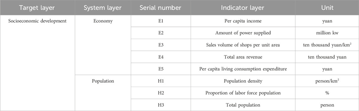
Table 2. Socioeconomic development indicators.
2.3 Construction of collaborative development mechanisms
Coupling was first proposed as a physical concept in physics, referring to the process of the interaction, mutual influence, and division of transmission energy and information of circuit components or electrical networks (Zhan et al., 2024). In recent years, the coupling method has been widely used in the field of land management to explore the complex interactions among land, economic and social systems and has shown unique advantages (Bian et al., 2024). Coordination refers to the harmonious interaction and virtuous cycle among system components, serving as a key feature of sustainable and healthy development. The degree of coordination indicates the extent to which systems achieve synchronized and sustained growth. The notion of coupled coordination development highlights the organic unity of “coupling–coordination–development,” representing a continuous process in which interrelated subsystems evolve from low-level cooperation toward a high-level, ordered state (Gong et al., 2019).
Assessing the intensity of land use and determining whether it aligns with socio-economic development needs are critical for achieving balanced and sustainable regional development. This study integrates the evaluation systems of land-use intensification and socio-economic development to construct a dynamic coupling coordination framework, aimed at revealing their internal evolution mechanism. Distinct from conventional static coupling approaches, this study embeds the Pressure–State–Response (PSR) model to capture the causal feedback chains of drivers–effects–adjustments within the land-use intensification subsystem, and its dynamic interactions with the socio-economic subsystem composed of population and economic dimensions (Chongbin, 1999).
In this framework, the pressure dimension represents external driving forces and constraints—primarily the environmental and spatial pressures induced by intensive land use. These pressures act as the fundamental forces shaping spatial structures and resource-use efficiency. The state dimension captures the outcomes of these pressures, namely, the current level of land-use intensification, reflected in indicators such as land-use efficiency and ecological performance. The response dimension encompasses the feedback actions taken to address imbalances revealed by the system state, including policy adjustments, spatial planning optimization, and management interventions. These responses in turn modify the original pressures, forming a cyclical feedback mechanism. Collectively, these three dimensions constitute a self-organizing, closed-loop feedback system, in which external pressures alter the system state, state changes trigger social responses, and responses subsequently mitigate or reinforce pressures—driving continuous self-adjustment and adaptation. The land and socio-economic systems thus interact dynamically through flows of energy, information, and policy, rather than existing as parallel entities (Chen et al., 2025).
In resettlement areas, scientifically planned and intensively managed land provides the material foundation for sustainable socio-economic development. Under the support of regional resources, spatial configuration, and infrastructure, improved land-use efficiency ensures the spatial and material basis for economic expansion and welfare enhancement. Conversely, socio-economic development influences land-use intensity and structure through changes in population distribution, industrial structure, and infrastructure demand, forming a feedback-driven, co-evolving land–economy–society system (Li C. et al., 2024).
At the pressure level, the land subsystem provides spatial capacity and physical support for socio-economic activities. Initial land development strategies (e.g., floor area ratio and building density) define the physical boundaries and development potential of resettlement communities, influencing their population-carrying capacity and commercial activity (e.g., retail sales per unit area). At the state level, the efficiency and structure of land use determine the operational quality of the socio-economic system. A functionally mixed land-use pattern (e.g., a land-use structure diversity index) promotes employment–residence integration and enhances tertiary sector employment, while a balanced residential land ratio ensures livability and strengthens social stability through higher migrant satisfaction. At the response level, land management and planning interventions shape institutional adaptability and governance effectiveness. Participatory land-use planning—in which migrants are involved in resettlement design—ensures that land allocation reflects local livelihood needs and community aspirations, thereby enhancing endogenous development capacity and social cohesion. This participatory process functions as an investment in social capital, with effects ultimately reflected in per capita income and overall socio-economic performance.
The two subsystems affect each other, promote each other, and operate together in a unified set of mutual contradictions (Chowdhury et al., 2024). First, effective planning for resettlement area land is a material basis and prerequisite for the sustainable development of the social economy of migrants. With the support of regional land resources and other elements, the growth of land use benefits provides resource, supply and security functions for the growth of social and economic benefits. Intensive land use and socioeconomic development develop in coordination in the same physical space; this coupling can be regarded as the epitome of the concept of sustainable development in the mesoscopic field of reservoir resettlement planning.
During this coupling process, subsystems evolve toward either equilibrium or imbalance. The “obstacle factors” identified through the obstacle degree model represent feedback deficiencies or adaptive limitations within the PSR causal chain. Integrating obstacle diagnosis with the PSR-based coupling coordination framework helps to elucidate the internal mechanisms driving the transition from inefficient feedback to effective coordination, offering theoretical insights for optimizing policy interventions and enhancing system adaptability and resilience. The conceptual framework is illustrated in Figure 1.
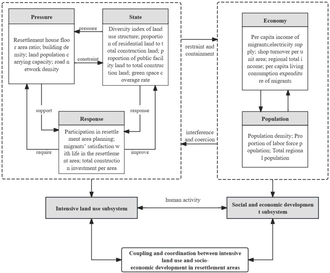
Figure 1. Map of the intensive land use and socioeconomic development coupling coordination mechanism of reservoir migration areas.
3 Materials and methods
3.1 Study area
The site of the W Water Conservancy Hub Engineering Dam is located in Luotan town, Jingdezhen. The project mainly involves flood prevention but also has the functions of water supply and power generation. The project involves 31 migrant resettlement areas. Z Town is located in northeastern Fuliang County. The Z Town resettlement area is one of the largest, with the largest population, and is the only migrant resettlement area in the form of an urban collective town. In accordance with the relevant requirements of migration resettlement of the W Reservoir, migrants who require resettlement to Z Town are not involved in the deployment of productive land (paddy fields and dry land). Therefore, the Z Town resettlement area no longer has productive agricultural land. After migrants are relocated, they will not rely on land to maintain their living standards and will instead maintain their livelihood through other channels. Z Town Migration Source Construction is divided into residential construction and nonresidential housing construction. In summary, the Z Town resettlement area holds significant representativeness and research value in terms of scale, landv-use patterns, socioeconomic development trajectory, and urbanization processes. By selecting this area as our research focus, we aim to provide a unique and valuable case study that elucidates the intricate coupling between land intensification and socioeconomic development. The geographical location of the Z Town resettlement area is shown in Figure 2 below.
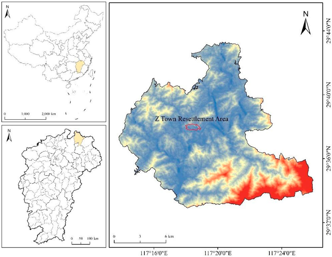
Figure 2. Study area.
From a long-term perspective, large-scale reservoir projects such as the W Water Conservancy Hub fundamentally reshape regional hydrological patterns and geomorphological structures, profoundly transforming the land-use system and its ecological foundation (Chowdhury et al., 2024). Inundation leads to the permanent loss of cultivated and forest land, while the construction of resettlement areas and related infrastructure drives the expansion of built-up land into agricultural and ecological spaces. This process restructures land-use patterns and weakens ecosystem functions, manifested in habitat fragmentation, biodiversity loss, and the degradation of ecological service capacity. The continuous operation of the reservoir further drives the spatiotemporal evolution of land use in both the reservoir and receiving areas, compelling the region to constantly seek a new equilibrium among production, living, and ecological spaces.
While the empirical findings of this study are derived from the specific context of Z Town, the research site embodies a set of characteristics that are increasingly representative of resettlement challenges in the era of rapid urbanization and infrastructure development. Unlike traditional agricultural resettlement models, Z Town’s unique “landless” resettlement approach—where migrants are decoupled from productive land and must integrate into non-agricultural sectors—represents a critical and growing paradigm. This model is particularly relevant for resettlement areas adjacent to urban centers or those driven by national strategies that prioritize industrial and service-oriented economies over agrarian ones. The socio-economic tensions and land-use governance issues revealed in Z Town, such as institutional inertia in land allocation and the mismatch between urban-built environments and residents’ livelihood needs, are not isolated phenomena. Instead, they offer a valuable lens through which to anticipate and analyze challenges in other regions undergoing similar forced transition. Therefore, the insights gleaned from this case study extend beyond a single locality; they contribute to a broader theoretical understanding of the intricate coupling between land intensification and socio-economic adaptation in contexts of involuntary, non-agricultural resettlement. The lessons from Z Town are crucial for policymakers and planners in designing more integrated and human-centered resettlement programs for infrastructure projects worldwide.
3.2 Data sources
The real values used in the analysis of the social and economic development of the Z Town resettlement area and the current status and infrastructure status of the Z Town resettlement zone involved in the institute are mainly from the W Reservoir Hub Engineering Project Headquarters, Z Town Resident Committee, and on-site survey data from an investigation carried out by the W Reservoir Hub Project Z Town resettlement area. The data presented in this article were collected at a critical time point following the successful completion of the resettlement efforts for Z Town, related to the W Reservoir, specifically in the year 2020. The ideal values for the index are mainly from the following three sources: 1) the state-promulgated documents on the construction of town planning, mainly including the “Village Planning Standards” (GB50188-93) and the “Town Planning Standard” (GB50188-2007); 2) the “W Detailed Plan for the Control of the County Z Town” and the “Water Conservation Hub Engineering Migration Resettlement Plan”; and 3) the “Report on the Completion of the Migration of the Water Conservancy Project for Loans”.
3.3 Methods
3.3.1 The comprehensive evaluation model
First, the evaluation indicators are standardized using the ideal value proportion method. Second, the weights of the indicators are determined through the Analytic Hierarchy Process (AHP) (Dongyan et al., 2022). Finally, the comprehensive scores are calculated based on the data of various indicators across the Pressure, State, and Response subsystems. The calculation formula is as follows:
where L represents the comprehensive value of intensive land use; SP, SS and SR are the weights of the three subsystems in terms of pressure, state, and response, respectively; n, m and l are the numbers of indicators of each subsystem; Wi represents the weight of the i-th indicator; and Yi represents the value after the i-th indicator is standardized. This study uses an ideal value ratio calculation method to achieve numerical standardization.
The comprehensive score of intensive land use can be obtained according to Formula 1. The results of the intensive land use classification of Z Town are determined with further reference to the existing research on land issues in urban areas and relevant intensive land use regulations, as shown in Table 3.

Table 3. Classification of intensive land use.
The comprehensive calculation model of social and economic development should be the result of comprehensive calculations of various indicators of the two subsystems of the economy and population. The calculation formula is shown below (Formula 2):
where U represents the comprehensive value of the development level of the migrating society; SE and SH are the weights of the two subsystems of the economy and population, respectively; j and k are the number of indicators of each subsystem; Wi represents the weight of the i-th indicator; and Yi represents the values of the i-th index.
A comprehensive score of socioeconomic development can be obtained based on Formula 4 and relevant research on the level of socioeconomic development in existing urban areas (Ting and Fawen, 2021), as shown in Table 4.

Table 4. Social and economic development level division.
3.3.2 Improved coupling coordination model
The coupling coordination model is useful at the level of coordination between different subsystems (Shi et al., 2024). It can also reflect the synchronization of the development speed and direction of the two subsystems and the comprehensive development level of the two subsystems. The improved coupling coordination model calculation formula is as follows (Wang et al., 2023b):
where L represents the comprehensive value of intensive land use, U represents the comprehensive value of the level of socioeconomic development, and C is the coupling of the intensive land use level and socioeconomic development level index.
where
where D is the coupling coordination of the two systems. When D is higher, the degree of coupling coordination between subsystems is greater, indicating that intensive land use matches the level of socioeconomic development in the resettlement area. A lower value of D indicates uncoordinated development. According to previous research (Wang et al., 2023b), this article divides the coupling coordination index D, and the specific results are shown in Table 5.
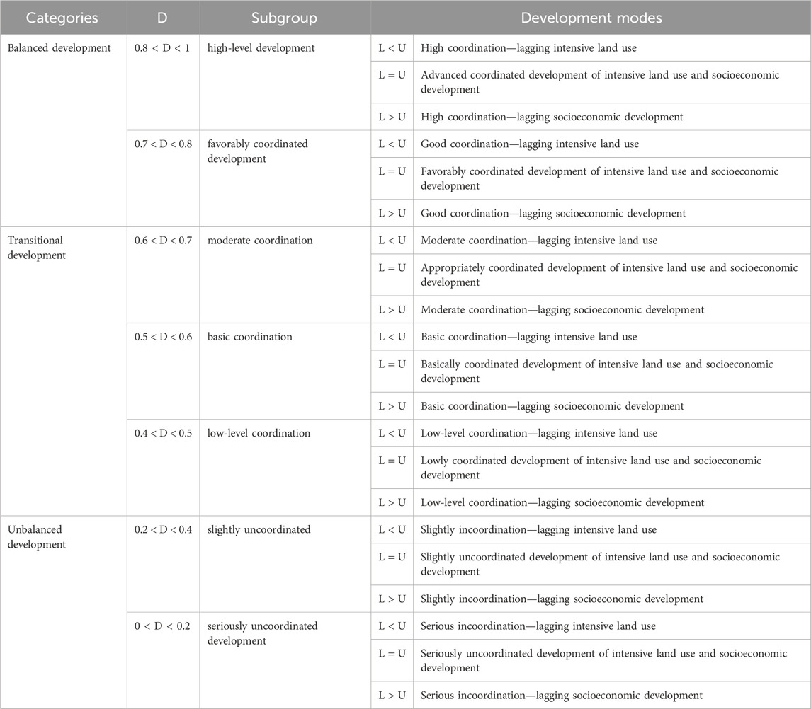
Table 5. Coupling coordination level division table.
3.3.3 Obstacle factor analysis
Based on the above comprehensive score formula, the value of the land intensive score L and the socioeconomic development comprehensive score U can be obtained for the resettlement area. The index obstacle factors are calculated using Formulas 7–10. This assessment aims to enhance the system’s comprehensive score and promote the coupling coordination level between the two subsystems (Zh et al., 2021; Shen et al., 2018).
where Ci represents the degree of factor contribution, which is the degree of influence of a single indicator on the results of the comprehensive evaluation; Wi represents the weight of the i-th indicator; and S is the system layer weight corresponding to the i-th indicator;
where Di represents the index deviation and Yi represents the value of the i-th index;
where hi represents the degree of index obstacles, which is the degree of influence of a single indicator on the comprehensive score;
where Hi represents the degree of subsystem obstacles, which is the degree of influence of the subsystem on the comprehensive score.
4 Results
4.1 Intensive land use of comprehensive evaluation results
Calculate the comprehensive value of intensive land use in Z Town based on the above comprehensive scoring method. See Table 6 for details.
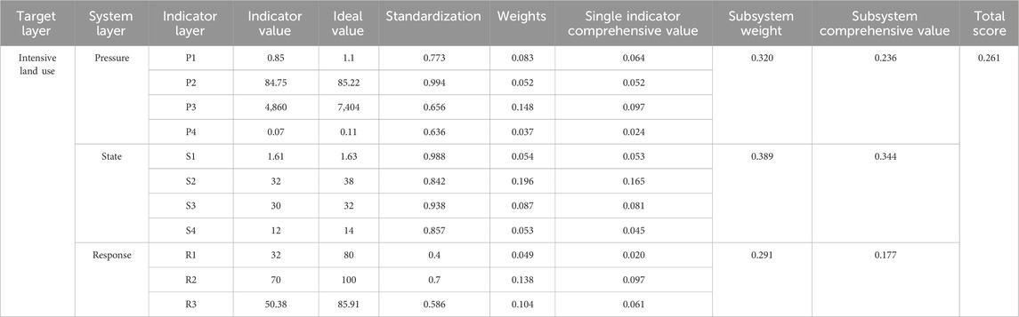
Table 6. Weights and comprehensive values of intensive land use evaluation indicators.
The results showed that the comprehensive score of the land set of migration resettlement areas in Z Town was 0.261, which is between 0.2 and 0.4. Table 3 shows that the land use is minimally intensive, and the phenomenon of inefficient land use is more serious. The comprehensive evaluation score of the pressure subsystem is 0.236, the state subsystem score is 0.344, and the response subsystem score is 0.177; in comparison, the state score is the highest, and its impact on the comprehensive evaluation is also the greatest.
The relatively strong performance of the state subsystem is mainly attributable to the fact that the actual values of its indicators are generally close to the planning targets. For instance, the proportion of land allocated to public facilities is 30%, slightly below the planned 32%, and the green space coverage is 12%, slightly below the planned 14%. Although these physical infrastructure indicators have not fully reached the ideal values, the deviations are limited, suggesting that the spatial layout and infrastructure provision in the resettlement area largely conform to planning requirements.
In contrast, the response subsystem constitutes a critical bottleneck restricting overall performance. Social indicators in particular exhibit substantial deficiencies: residents’ participation in planning is only 32%, far below the target of 80%, and life satisfaction is 70%, also below the ideal value of 100%. This marked disparity indicates that the challenges facing Town Z, as a land-lost resettlement area, extend beyond mere physical infrastructure development, and are closely associated with deficiencies in social integration and governance participation mechanisms, reflecting a pronounced system-level response failure.
Considering the regional characteristics of “no production land and high reliance on non-agricultural livelihoods,” the strong dependence of residents on off-farm employment exacerbates the “household-resident separation” phenomenon. This not only constrains the practical feasibility of residents’ participation in planning and community affairs, but also diminishes their sense of belonging and life satisfaction within the resettlement area. Consequently, the indicators reveal a clear divergence between the state and response subsystems, highlighting the structural social contradictions underlying the low level of land intensification in Town Z, namely, the misalignment between physical infrastructure development and social functional development.
4.2 Comprehensive evaluation results of socioeconomic development
Calculate the comprehensive value of the socioeconomic development level of immigrants in Z Town based on the above comprehensive scoring method. See Table 7 for details.
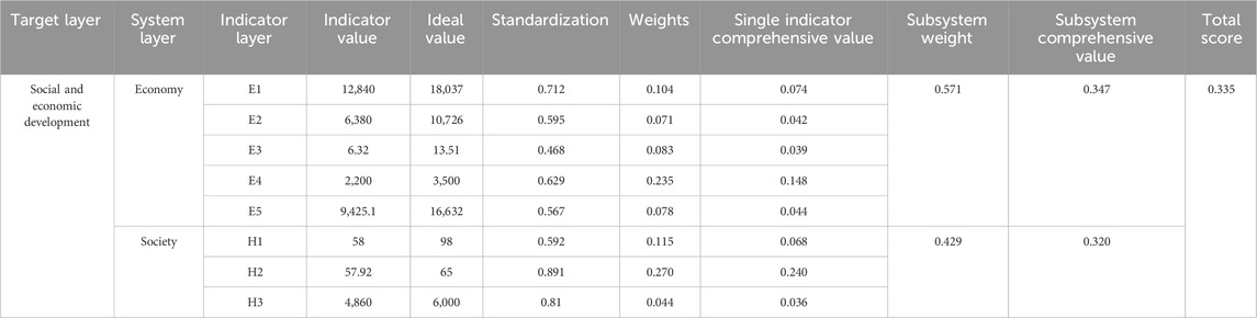
Table 7. Social and economic development system evaluation index weight and comprehensive value.
The comprehensive score of the social and economic development of the Migration Resettlement District of Z Town is 0.335, which is between 0.3 and 0.4. According to Table 4, the socioeconomic development of the resettlement area is at a mid-low level, meaning that it is relatively lagging. The comprehensive evaluation score of the economic subsystem is 0.347, and the population subsystem score is 0.320. The economic subsystem exhibits significant gaps relative to the ideal values: per capita income is 12,840 yuan, reaching only 71.2% of the target value of 18,037 yuan; the turnover per unit area of commercial shops is 6.32, less than half of the ideal value of 13.51, indicating that both commercial vitality and residents’ income levels in the resettlement area are substantially inadequate. The social subsystem also shows structural problems: the proportion of the labor force is 57.92%, below the reasonable threshold of 65%; population density is only 58 persons, far below the planned carrying capacity of 98 persons, reflecting the “household-resident separation” and population outflow resulting from limited livelihood resources. The absence of local industrial support forces a large portion of the labor force to seek off-farm employment, which not only constrains local consumption and commercial development but also undermines community population stability and social vitality, further exacerbating the vicious cycle between inefficient land use and economic development. These findings reveal, from a socio-economic perspective, the underlying causes of the low level of system coordination in the resettlement area.
4.3 Analysis of the coupling coordination results
From Table 4, 5, the intensive value of the intensive land use of the resettlement area L = 0.261 and the comprehensive value of the level of socioeconomic development U = 0.335 are substituted into the system coordination function Formula 3 to calculate the coordination degree C = 0.992 between the two subsystems. According to Formula 4, the importance coefficient of intensive land utilization is
According to Table 4, the two subsystems of land intensive and social and economic development levels in Z Town are in the stage of primary coupling coordination, L = 0.261 < U = 0.335. Moreover, the level of intensive land use in the resettlement area is slightly lower than the level of socioeconomic development.
4.4 Obstacle factor analysis
This paper analyzes the obstacles hindering intensive land use systems. The specific diagnosis results are shown in Table 8. According to the analysis of the factors influencing intensive land use in Z Town, most of the obstacles occurred in the land pressure subsystem in the resettlement area, which accounted for 40.24%; thus, this subsystem is one of the main areas for improvement. To improve the level of intensive land use in the resettlement area, it is necessary to start with the land pressure system. At the same time, attention should be given to the impact of changes in the state of the land on the land pressure system and response system.
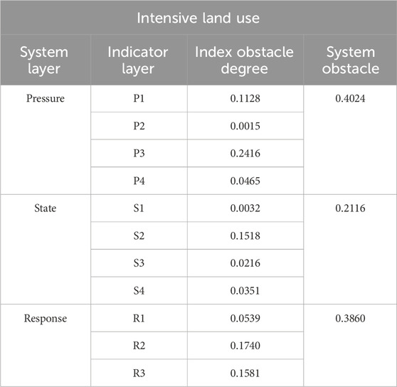
Table 8. Obstacle factor analysis results.
From the perspective of the indicator layer of the land use system, the obstacle factors that affect the use of intensive land use are mainly P3, land population carrying capacity; followed by R2, migrants’ satisfaction with life in the resettlement area; R3, the total investment amount of the land; and S2, the overall total residential land. The proportions of construction land in each of these factors are 24.16%, 17.40%, 15.81%, and 15.18%, respectively. The sum of these four index obstacles reached 72.55%.
5 Discussion
While grounded in the specific case of Z Town, this study highlights challenges—such as institutional inertia in land governance and mismatches between land use and livelihood needs—that hold global relevance. As infrastructure-driven resettlement projects worldwide increasingly transition toward urbanized and non-agricultural models, the findings from Z Town provide transferable insights for peri-urban resettlement contexts undergoing rapid socioeconomic transformation.
Our analysis reveals that the interaction between intensive land use and socioeconomic development in the resettlement area remains at a stage of primary coupling coordination. This imbalance primarily arises because land-use planning in reservoir-induced resettlement areas has not fully incorporated long-term development demands, particularly the quality of migrant life and the pursuit of sustainability (He et al., 2023). A deeper analysis reveals that this lag in the land system is not an isolated phenomenon, but rather a concentrated manifestation of the ruptures or delays occurring at multiple stages along the “Pressure–State–Response” (PSR) chain.
This phenomenon reflects a complex interplay of financial, economic, and temporal dynamics that collectively shape the process of land-use optimization. Despite the initial planning of Z Town demonstrating notable foresight—with substantial investments in infrastructure and public services such as transportation, public squares, administrative institutions, and commercial facilities—the absence of stable and long-term financial resources has hindered the effective operation, maintenance, and upgrading of these facilities (Shaojun et al., 2022). In essence, this reflects the inefficacy of the Response subsystem (R), which fails to effectively address the issues emerging within the State subsystem (S). Consequently, it cannot alleviate the new Pressures (P) arising from population agglomeration and economic growth, ultimately undermining the socio-economic vitality of the resettlement areas and, in turn, constraining improvements in land-use intensity. Bridging this gap requires sustained institutional commitment and resource allocation, as short-term capital investment alone is insufficient to ensure sustainable development (Zhang et al., 2024b).
It is noteworthy that the case of Town Z represents a distinctive form of relocation induced by reservoir construction, where the observed land-use lag stems from planning rigidity and institutional inertia. Once initial land-use schemes—such as road networks and spatial layouts—are established, they become difficult to modify, resulting in a spatial lock-in effect. When rapid socio-economic transitions, such as livelihood diversification and population outmigration, generate new spatial demands, the inflexible land-supply structure fails to respond in a timely manner, leaving the land system unable to support emerging development patterns. For example, the excessive proportion of residential land and the oversized per capita construction area reflect a mismatch between planning assumptions and actual demographic or livelihood shifts, leading to imbalanced resource allocation and inefficient land use.
Although the new town has been in operation for a relatively short period, land-use intensity is expected to improve as urban functions mature and planning frameworks evolve, consistent with findings from other resettlement studies. However, overcoming the land-use lag is not an automatic process; it requires proactive policy intervention and institutional innovation to reestablish the PSR feedback mechanism. Specifically, this involves developing a dynamic planning evaluation and adjustment system that aligns land supply with changing socio-economic pressures, improving investment and financing mechanisms to enhance long-term responsiveness, and incorporating migrant satisfaction and other social feedback into land-governance processes. Through such reforms, the land system can shift from a passive resource provider to an adaptive institutional enabler, thereby achieving higher-level coordination with the socio-economic system.
Furthermore,the factors hindering the level of land-intensive utilization are prominently reflected in land population carrying capacity, migrants’ satisfaction with life in the resettlement area, the total construction investment per area, and the proportion of residential land to total construction land. Together, these factors constitute the core bottlenecks to the coordinated development of the human–land system in resettlement areas, and their underlying mechanisms are as follows.
1. Land population carrying capacity. The land population load index reflects the population that the land can accommodate and that can be maintained with sustainable living practices (Cheng et al., 2023). The structural imbalance in land–population carrying capacity reflects a profound discrepancy between planning projections and actual development trajectories (Yan et al., 2017; Lane, 2010). In accordance with the relevant requirements of migration resettlement of the W Reservoir, migrants who require resettlement to Z Town are not involved in the deployment of productive land (paddy fields and dry land). After the migrants relocated, they were unable to rely on their original land to maintain their living standards. The migrants’ means of obtaining a livelihood were forced to change, and most of them were transformed from traditional agricultural methods (Fu and Xiaoyan, 2019; Ma et al., 2022). However, the resettlement area cannot meet the needs of a large number of migrant laborers and urbanization (Knudsen and Agergaard, 2015; Cong et al., 2017). These reasons ultimately lead a significant portion of migrants in the town to choose to work in the city or elsewhere, or to own houses in the town without actually residing there. As a result, the planned population capacity is greatly diminished, creating a substantial gap in the land’s population carrying capacity in the resettlement area.
2. Migrants’ satisfaction with life in the resettlement area. Migrants’ satisfaction with living conditions in the resettlement area is closely linked to their attitudes toward and engagement in land use. Field investigations reveal that most migrants were unaware of key decisions such as the site selection and planning of Town Z; many only learned of these arrangements during or even after the planning process, leaving them in a passive position throughout relocation (Chen W. et al., 2023). The absence of participatory mechanisms and the resulting low satisfaction levels expose a failure in the governance system’s responsiveness. The marginalization of migrants in planning and decision-making not only weakens their identification with land policies but also diminishes their willingness to participate in community governance and land management (Xiaojun and Jiajun, 2016). The essential driving force of urbanization should lie in the pursuit of a better rural life, which ultimately serves as the benchmark for evaluating its success (Jiang et al., 2021). As direct users and stakeholders of land resources, migrants’ needs must be effectively integrated into planning processes; otherwise, a disconnection will arise between land-use schemes and actual local demands.
3. The total construction investment per area. The total investment amount of land reflects the degree of development and utilization of land. Insufficient construction investment per unit area highlights the limitations of existing financial support mechanisms (Bai et al., 2014). Resettlement areas are generally constrained by weak industrial foundations and limited fiscal capacity, making it difficult to attract sustained social capital investment. As a result, the maintenance of infrastructure and the provision of public services often lack stable financial backing. This not only undermines the functionality of existing facilities but also constrains the potential for land value appreciation (Xinyuan et al., 2021).
4. The proportion of residential land to total construction land. The proportion of residential land to total construction land reflects the proportion of residential land in the land use structure. An imbalanced proportion, together with excessive per capita land allocation, reveals structural deficiencies in spatial resource distribution (Belmiro et al., 2023). In Town Z’s resettlement area, the per capita construction land reaches 141 m2 per person—significantly exceeding the 80–100 m2 range recommended by the Town Planning Standard (GB50188-2007). Such an extensive land-use pattern not only encroaches upon the spatial needs for industrial development and public services but also directly impedes improvements in land-use intensity.
These four constraining factors are interrelated and mutually reinforcing: population outflow weakens investment attractiveness; low satisfaction undermines population stability; inadequate investment limits improvements in spatial quality; and an unbalanced land-use structure further accelerates the outmigration of both people and industries. Therefore, enhancing land-use intensity in resettlement areas requires moving beyond single-factor interventions and adopting a systemic, multi-dimensional approach integrating demographic, economic, social, and spatial dimensions. The focus should be on strengthening planning flexibility, establishing participatory mechanisms for migrants, innovating financing models, and optimizing land-use structures, thereby fostering the coordinated evolution of the human–land system toward a higher level of integration and sustainability.
6 Conclusion
This study investigates the coordination between intensive land use and socioeconomic development in reservoir resettlement areas, a critical issue for achieving sustainable regional transformation. By integrating an improved coupling coordination model with multi-dimensional evaluation indicators, the research not only provides a more accurate assessment of land-use intensity and socioeconomic development but also advances methodological tools for analyzing the dynamic interaction between these two subsystems. Compared with previous approaches, the proposed framework captures both the structural imbalances and the underlying institutional and livelihood-related constraints that shape land–society coordination in resettlement contexts.
Empirical results from Z Town demonstrate that intensive land use remains minimally developed (0.261) relative to socioeconomic progress (0.335), with the two subsystems currently at the stage of primary coupling coordination. The study further identifies population carrying capacity, migrants’ satisfaction with resettlement life, construction investment per unit of land, and the residential-to-total construction land ratio as the most critical obstacles impeding land-use efficiency. These findings underscore the importance of addressing not only physical and financial inputs but also institutional mechanisms and livelihood-oriented planning to promote long-term coordination.
Although the research is based on a geographically specific case, its implications extend well beyond Z Town. The methodological framework is replicable and adaptable to diverse resettlement and displacement contexts worldwide, particularly in regions affected by dams, mining, and ecological restoration projects. More broadly, the findings speak to global debates on sustainable development, offering practical insights for underdeveloped and developing regions where low land-use efficiency coexists with socioeconomic underdevelopment.
By highlighting the complex interplay between institutional inertia, financial sustainability, and social adaptation, this study contributes to both theory and practice. Theoretically, it enriches the discourse on land–society interactions by demonstrating how multi-scalar constraints shape coupling coordination. Practically, it provides targeted strategies for improving land-use efficiency, strengthening livelihood security, and fostering socially inclusive and resource-efficient growth. In doing so, the research not only supports national resettlement policy design but also aligns with the broader objectives of the United Nations Sustainable Development Goals, particularly Sustainable Cities and Communities, Responsible Consumption and Production, and Climate Action.
7 Limitations and future work
This study uses an improved coupling coordination model to explore the relationship between the two subsystems of the land use area of Z Town. The results of the research can be used to adjust the measures considered according to local conditions, promote continuous improvement, and provide a reference for policymakers in the top-level design of national policies to better benefit people’s quality of life. There are certain limitations in this study that can be improved upon in future research. Limited by data acquisition and a lack of long-term data support, we did not explore the long-term coupling coordination relationship between the two subsystems in the resettlement area. Determining how to explore long-term coupling coordination relationships, more reasonably delineate regional types, and help managers accurately carry out improvement work is the focus of further research.
Data availability statement
The original contributions presented in the study are included in the article/supplementary material, further inquiries can be directed to the corresponding authors.
Author contributions
KZ: Data curation, Investigation, Methodology, Writing – original draft, Writing – review and editing. SC: Conceptualization, Funding acquisition, Methodology, Resources, Writing – review and editing. BL: Conceptualization, Data curation, Visualization, Writing – review and editing.
Funding
The authors declare that financial support was received for the research and/or publication of this article. This work was supported by the Key Research Project of the National Foundation of Social Science of China: Community Governance and Post-Relocation Support in Cross District Resettlement (grant numbers 21 and ZD183); the Fundamental Research Funds for the Central Universities: Study On The Coordinated Development Of Sustainable Livelihood And Ecological Protection Of Relocated Farmers (grant number: B240207032). 2025 Jiangsu Postgraduate Research and Practice Innovation Program (grant number: KYCX25_0877).
Conflict of interest
The authors declare that the research was conducted in the absence of any commercial or financial relationships that could be construed as a potential conflict of interest.
Generative AI statement
The authors declare that no Generative AI was used in the creation of this manuscript.
Any alternative text (alt text) provided alongside figures in this article has been generated by Frontiers with the support of artificial intelligence and reasonable efforts have been made to ensure accuracy, including review by the authors wherever possible. If you identify any issues, please contact us.
Publisher’s note
All claims expressed in this article are solely those of the authors and do not necessarily represent those of their affiliated organizations, or those of the publisher, the editors and the reviewers. Any product that may be evaluated in this article, or claim that may be made by its manufacturer, is not guaranteed or endorsed by the publisher.
References
Bai, X. M., Shi, P. J., and Liu, Y. S. (2014). Society: realizing China's urban dream. Nature 509, 158–160. doi:10.1038/509158a
Belmiro, C., Neto, R. D. S., Barros, A., and Ospina, R. (2023). Understanding the land use intensity of residential buildings in Brazil: an ensemble machine learning approach. Habitat Int. 139, 12. doi:10.1016/j.habitatint.2023.102896
Bian, D., Zhang, M., Kong, L., Huang, B., and Hu, D. (2024). Analysis of regional social–economic spatial pattern and evolution along the beijing–Hangzhou Grand canal. Sustainability 16, 1527. doi:10.3390/su16041527
Chao, W., Zhou, W., Jian, X., and Gui, J. (2024). Trade-off or synergy? Dynamic analysis and policy insights on land use functions in China. Environ. Impact Assess. Rev., 105107399. doi:10.1016/J.EIAR.2023.107399
Chen, X., Yu, H., Ding, M., and Shu, H. (2023a). The impact of regional socio-economic development on spatial and temporal differences in the distribution pattern of top-tier education in China. Sustainability 15, 15277. doi:10.3390/su152115277
Chen, W., Dan, Z., and Kaiwen, Y. (2023b). Research on resettlement satisfaction and influencing factors based on Reservoir resettlement perspective. China Rural Water Hydropower, 256–261. doi:10.12396/znsd.230341
Chen, M., Zhang, Q., Jiang, Y., Wang, J., and Zhu, S. (2025). Evaluating the coupling coordination levels and critical obstacle indicators of urban infrastructure resilience: a case Study in China. Buildings 15, 495. doi:10.3390/buildings15030495
Cheng, H. R., Zhu, L. K., and Meng, J. J. (2022). Fuzzy evaluation of the ecological security of land resources in mainland China based on the pressure-state-response framework. Sci. Total Environ. 804, 150053. doi:10.1016/j.scitotenv.2021.150053
Cheng, Z., Zaijian, Q., and Zhenyan, H. (2023). Evolutionary game analysis of post-relocation support projects for Reservoir resettlement: evidence from China. Soc. Indic. Res. 167 (1-3), 135–152. doi:10.1007/s11205-023-03101-0
Chi, Y. L., and Mak, H. W. L. (2021). From comparative and statistical assessments of liveability and health conditions of districts in Hong Kong towards Future City development. Sustainability 13, 8781. doi:10.3390/su13168781
Chongbin, L. (1999). Quantitative evaluation and classification system of coordinated development of environment and economy: a case study of the urban agglomeration in the Pearl River Delta. Trop. Geogr., 76–82.
Chowdhury, A. F. M. K., Wild, T., Zhang, Y., Binsted, M., Iyer, G., Kim, S. H., et al. (2024). Hydropower expansion in eco-sensitive river basins under global energy-economic change. Nat. Sustain 7, 213–222. doi:10.1038/s41893-023-01260-z
Cong, L., Ping, L., Xiuhua, H., and Weilin, F. (2017). The impact mechanism of relocation on rural households' out-migration in south of Shaanxi Province. J. Xi'an Jiaot. Univ. Sci. 37, 64–71. doi:10.15896/j.xjtuskxb.201701009
Deng, X., and Song, M. (2025). “Global convergence of regional Socio-economic development,” in Development geography (Singapore: Springer). doi:10.1007/978-981-96-6917-2_12
Dongyan, G., Dongyan, W., Xiaoyong, Z., and Yuanyuan, Y. (2022). Evaluation of the high-quality development level of the beijing-tianjin-hebei region and diagnosis of obstacle factors. Statistics and Decis. 38, 122–126. doi:10.13546/j.cnki.tjyjc.2022.15.023
Fu, H., and Xiaoyan, Li (2019). Evaluation of spatial suitability of site selection for resettlement areas in Southern Shaanxi: a case Study of Mian county. China Agric. Resour. Zoning 40 (04), 112–121.
Gao, Y., Wang, Z., Chai, J., and Zhang, H. (2024). Spatiotemporal mismatch of land use functions and land use efficiencies and their influencing factors: a case study in the Middle Reaches of the Yangtze River, China. J. Geogr. Sci. 34, 62–88. doi:10.1007/s11442-024-2195-1
Gong, J., Liu, D. Q., Zhang, J. X., Xie, Y. C., Cao, E. J., and Li, H. Y. (2019). Tradeoffs/synergies of multiple ecosystem services based on land use simulation in a mountain-basin area, western China. Ecol. Indic. 99, 283–293. doi:10.1016/j.ecolind.2018.12.027
Gui, J. I. N., Peng, J., Zhang, L., and Zhang, Z. (2023). Understanding land for high-quality development. J. Geogr. Sci. 33 (2), 217–221. doi:10.1007/s11442-023-2079-9
Hammad, A. W., Akbarnezhad, A., Haddad, A., and Vazquez, E. G. (2019). Sustainable zoning, land-use allocation and facility location optimisation in smart cities. Energies 12, 1318. doi:10.3390/en12071318
Haoxuan, L. (2017). A Study on rural land conservation and intensive utilization in China in the process of urban-rural integration: based on an improved PSR model. Inq. Into Econ. Issues, 38–46.
He, X. R., Cai, C. Y., Tang, J. X., Shi, J. Z., and Yang, R. B. (2023). Analysis of coupling coordination and obstacle factors between tourism development and ecosystem services value: a case study of the Yellow River Basin, China. Ecol. Indic. 157, 111234. doi:10.1016/j.ecolind.2023.111234
Hui, C. E., Wu, Y., Deng, L., and Zheng, B. (2015). Analysis on coupling relationship of urban scale and intensive use of land in China. Cities 42, 4263–4269. doi:10.1016/j.cities.2014.09.002
Jiang, Z., and Zhou, J. (2024). Spatio-temporal coupling characteristics and driving factors of land intensive use and green economic efficiency in the Yangtze River Economic Belt. Resour. Environ. Yangtze Basin 33 (4), 742–757. doi:10.11870/cjlyzyyhj202404006
Jiang, T., Wang, M., Zhang, Y., Shi, G., and Yan, D. (2021). What about the “Stayers”? Examining China’s resettlement induced by large reservoir projects. Land 10, 166. doi:10.3390/land10020166
Kalantari, Z., Ferreira, S. S. C., Page, J., Goldenberg, R., Olsson, J., and Destouni, G. (2019). Meeting sustainable development challenges in growing cities: coupled social-ecological systems modeling of land use and water changes. J. Environ. Manag., 245471–245480. doi:10.1016/j.jenvman.2019.05.086
Kexin, Z., Shaojun, C., Bing, L., and Xu, W. (2023). Research on the evaluation of intensive land use in resettlement area of Reservoir resettlement town based on PSR model. China Rural Water Hydropower, 206–211+216. doi:10.12396/znsd.222414
Knudsen, M. H., and Agergaard, J. (2015). Ghana's cocoa frontier in transition: the role of migration and livelihood diversification. Geogr. Ann. Ser. B, Hum. Geogr. 97, 325–342. doi:10.1111/geob.12084
Kou, Y., Chen, S., Zhou, K., Qiu, Z., He, J., Shi, X., et al. (2024). Spatiotemporal patterns and coupling coordination analysis of multiscale social–economic–ecological effects in ecologically vulnerable areas based on multi-source data: a case Study of the tuha Region, Xinjiang Province. Land 13, 282. doi:10.3390/land13030282
Lane, M. (2010). The carrying capacity imperative: assessing regional carrying capacity methodologies for sustainable land-use planning. Land Use Pol. 27, 1038–1045. doi:10.1016/j.landusepol.2010.01.006
Li, T., Zhang, S., and Li, H. (2024a). Research on social and economic factors influencing regional mortality patterns in China. Sci. Rep. 14, 10614. doi:10.1038/s41598-024-61262-5
Li, C., Bao, Y., Li, Y., Yue, M., Wu, L., Mao, Y., et al. (2024b). Assessment of the coupling coordination relationship between the green financial system and the sustainable development system across China. Sci. Rep. 14, 11534. doi:10.1038/s41598-024-62471-8
Ma, H., Zhong, Y., Ou, M., Wang, W., and Feng, X. (2022). The transformation of fishermen’s livelihoods in the context of a comprehensive fishing ban: a case Study of Datang village at the Poyang Lake Region, China. Land 11, 2262. doi:10.3390/land11122262
Pan, Y., Liu, J., and Cheng, C. (2024a). Research on urban resilience from the perspective of land intensive use: indicator measurement, impact and Policy implications. Buildings 14 (8), 2564. doi:10.3390/buildings14082564
Pan, H. H., Du, Z. Q., Wu, Z. T., Zhang, H., and Ma, K. M. (2024b). Assessing the coupling coordination dynamics between land use intensity and ecosystem services in Shanxi's coalfields, China. Ecol. Indic. 158, 111321. doi:10.1016/j.ecolind.2023.111321
Peng, C., Chen, L., and Han, F. (2014). The spatio-temporal evolution and relationship between new-type urbanization and intensive land use. Geogr. Res. 33 (11), 2005–2020. doi:10.11821/dlyj201411002
Peng, K. F., Jiang, W. G., Ling, Z. Y., Hou, P., and Deng, Y. W. (2021). Evaluating the potential impacts of land use changes on ecosystem service value under multiple scenarios in support of SDG reporting: a case study of the Wuhan urban agglomeration. J. Clean. Prod. 307, 127321. doi:10.1016/j.jclepro.2021.127321
Peng, S., Wang, J., Sun, H., and Guo, Z. (2022). How does the spatial misallocation of land resources affect urban industrial transformation and upgrading? Evidence from China. Land 11, 1630. doi:10.3390/land11101630
Qiao, W. Y., Hu, B., Guo, Z., and Huang, X. J. (2023). Evaluating the sustainability of land use integrating SDGs and its driving factors: a case study of the Yangtze River Delta urban agglomeration, China. Cities 143, 104569. doi:10.1016/j.cities.2023.104569
Rulian, W., and Hongyi, L. (2020). Evaluation of intensive land use of national comprehensive tourism demonstration areas based on PSR model: a case of Shangrao City. Ecol. Econ. 36, 129–134.
Shao, J., and Min, B. (2025). Sustainable development strategies for Smart cities: Review and development framework. Cities 158, 158105663–105663. doi:10.1016/J.CITIES.2024.105663
Shaojun, C., Jie, G., and Peng, T. (2022). Unintended consequences and changes of the late supporting policies for Reservoir resettlement. J. Hohai Univ. Soc. Sci. 24, 77–82+115. doi:10.3876/j.issn.1671-4970.2022.03.010
Shen, L. Y., Huang, Y. L., Huang, Z. H., Lou, Y. L., Ye, G., and Wong, S. W. (2018). Improved coupling analysis on the coordination between socio-economy and carbon emission. Ecol. Indic. 94, 357–366. doi:10.1016/j.ecolind.2018.06.068
Shi, G., Liang, B., Ye, T., Zhou, K., and Sun, Z. (2024). Exploring the coordinated development of smart-city clusters in China: a case Study of Jiangsu Province. Land 13, 308. doi:10.3390/land13030308
Siabi, K. E., Bah, K. T. A., Anornu, G., Akpot, K., Mortey, E., Incoom, A. B. M., et al. (2025). Future land use simulation modeling for sus-tainable urban development under the shared socioeconomic pathways in West African megacities: insights from Greater Accra Region. J. Environ. Manag., 376124300. doi:10.1016/J.JENVMAN.2025.124300
Sun, X., and Qin, Y. (2021). Evaluation of urban land intensive use based on PSR model: a case study of Suzhou City. J. Southwest Univ. Nat. Sci. Ed. 43 (4), 100–108. doi:10.13718/j.cnki.xdzk.2021.04.013
Sun, P., Lyu, F., Xiu, C., and Xie, C. (2015). Basic understanding and evaluation of urban land conservation and intensive use in China under new urbanization. Econ. Geogr. 35 (8), 178–183+195. doi:10.15957/j.cnki.jjdl.2015.08.025
Ting, Y., and Fawen, Y. (2021). “Evaluation of high-quality agricultural development based on entropy weight TOPSIS method and diagnosis of obstacle factors,” Soc. Sci. 76–83.
Wang, H., Wu, K., Feng, Z., Zhao, H., Ai, H., and Meng, C. (2023a). Evaluation of urban commercial land use intensification based on land parcels: taking Wuxi City as an example. Land 12, 1608. doi:10.3390/land12081608
Wang, H., Lu, X., Guo, Q., and Zhang, Y. (2023b). The spatiotemporal measurement of coordinated development of resource-environment-economy based on empirical analysis from China’s 30 provinces. Sustainability 15, 6995. doi:10.3390/su15086995
Weixiang, X., Zhixiong, X., and Chengjun, L. (2021). Coupling analysis of land intensive use efficiency and ecological well-being performance of cities in the Yellow River Basin. J. Nat. Resour. 36, 114–130. doi:10.31497/zrzyxb.20210108
Wu, Y., Ao, J., and Ren, Y. (2023). Allocation of land factors in China looking forward to 2035: planning and market. Int. J. Environ. Res. Public Health 20 (4), 3424. PMID: 36834119; PMCID: PMC9966933. doi:10.3390/ijerph20043424
Xiaojun, L., and Jiajun, H. (2016). The effect of Reservoir migrants' income on rural household expenditure: the perspective of the RD model. Consum. Econ. 32, 28–33+15.
Xinyuan, L., Xiaobin, J., Rui, S., et al. (2021). A typical phenomenon of cultivated land use in China's economically developed areas: Anti-intensification in Jiangsu Province. Land Use Policy, 102. doi:10.1016/j.landusepol.2020.105223
Xiong, X., Yan, T., Duan, Y., and Jun, X. (2021). Research status and hotspots of urbanization quality in China: a knowledge graph analysis. Hum. Geogr. 36 (04), 37–43. doi:10.13959/j.issn.1003-2398.2021.04.005
Yan, H. M., Liu, F., Liu, J. Y., Xiao, X. M., and Qin, Y. W. (2017). Status of land use intensity in China and its impacts on land carrying capacity. J. Geogr. Sci. 27, 387–402. doi:10.1007/s11442-017-1383-7
Yang, J., Jin, G., Huang, X., Chen, K., and Meng, H. (2018). How to measure urban land use intensity? A perspective of multi-objective decision in Wuhan urban agglomeration, China. Sustainability 10 (11), 3874. doi:10.3390/su10113874
Yin, X., Li, Y., Yuan, T., and Jing, W. (2020). Comprehensive measurement of town-level economic development and land intensive use level and analysis of their correlation: a case study of 109 sampled towns in Jiangsu Province. J. Nat. Resour. 35 (3), 614–625. doi:10.31497/zrzyxb.20200309
Yu, Y. G., Bao, Y. Z., Zhang, Q., Shen, P. Y., Yang, H., and Xu, Z. C. (2023). Evaluation of marine resources environmental responsibility audit based on PSR framework. Ocean. Coast. Manage 245, 106742. doi:10.1016/j.ocecoaman.2023.106742
Zhang, L., Wu, M. Q., Bai, W. L., Jin, Y. Z. Z., Yu, M. Q., and Ren, J. Z. (2021). Measuring coupling coordination between urban economic development and air quality based on the fuzzy BWM and improved CCD model. Sust. Cities Soc. 75, 103283. doi:10.1016/j.scs.2021.103283
Zhan, B., Jiang, C., Su, J., Xu, K., Bao, H., and Lin, C. (2024). “Research on the factors impacting the spatial reconstruction of resettled communities—Based on space production theory,” in CRIOCM 2023. Lecture notes in operations research. Singapore: Springer. doi:10.1007/978-981-97-1949-5_99
Zhang, F., Hao, J., Jiang, G., Zhongyi, D., Xinbo, L., and Tao, T. (2005). Spatio-temporal variation of urban land use intensity in China. China Land Sci. 19 (1), 23–29. doi:10.13708/j.cnki.cn11-2640.2005.01.004
Zhang, Y., Liao, H., Li, T., Zhang, X., and Long, H. (2020a). Evaluation of land intensive use potential and research on stock land tapping based on parcel scale: a case study of yubei district, chongqing. J. Southwest Univ. Nat. Sci. Ed. 42 (2), 66–75. doi:10.13718/j.cnki.xdzk.2020.02.010
Zhang, P., Yang, D., Qin, M., and Jing, W. (2020b). Spatial heterogeneity analysis and driving forces exploring of built-up land development intensity in Chinese prefecture-level cities and implications for future Urban land intensive use. Land Use Policy 99, 104958. doi:10.1016/j.landusepol.2020.104958
Zhang, H., Cao, Z., Zhou, K., and Ji, Y. (2024a). Research on the relationship between social capital and sustainable livelihood: evidences from reservoir migrants in the G Autonomous Prefecture, China. Front. Environ. Sci. 11DOI, 1358386. doi:10.3389/FENVS.2023.1358386
Zhang, H., Cao, Z., Zhou, K., and Ji, Y. (2024b). Research on the relationship between social capital and sustainable livelihood: evidences from reservoir migrants in the G Autonomous Prefecture, China. Front. Environ. Sci. 11, 1358386. doi:10.3389/fenvs.2023.1358386
Zhao, Q., Liu, H., Zhang, P., Deng, C., and Li, Y. (2025). Evaluation of arable land intensive utilization and diagnosis of obstacle factors from the perspective of public emergencies: a case Study of Sichuan Province in China based on the pressure-state-response model. Land 14, 864. doi:10.3390/land14040864
Keywords: reservoir resettlement, land use transformation, socioeconomic development, coupling coordination, PSR framework
Citation: Zhou K, Chen S and Liang B (2025) How does land use transformation coordinate with socioeconomic development in reservoir resettlement areas? Evidence from a Chinese town. Front. Environ. Sci. 13:1700832. doi: 10.3389/fenvs.2025.1700832
Received: 07 September 2025; Accepted: 10 November 2025;
Published: 25 November 2025.
Edited by:
Hugo Wai Leung Mak, Hong Kong University of Science and Technology, Hong Kong SAR, ChinaReviewed by:
Huakun Zhou, Chinese Academy of Sciences (CAS), ChinaGui Jin, China University of Geosciences Wuhan, China
Copyright © 2025 Zhou, Chen and Liang. This is an open-access article distributed under the terms of the Creative Commons Attribution License (CC BY). The use, distribution or reproduction in other forums is permitted, provided the original author(s) and the copyright owner(s) are credited and that the original publication in this journal is cited, in accordance with accepted academic practice. No use, distribution or reproduction is permitted which does not comply with these terms.
*Correspondence: Kexin Zhou, MjMwMjE0MTYwMDA0QGhodS5lZHUuY24=; Shaojun Chen, c2pjaGVuQGhodS5lZHUuY24=