 Kwadwo Kyenkyehene Kusi
- Forestry Research Institute of Ghana, Council for Scientific and Industrial Research, Kumasi, Ghana
Trees outside forests (TOF) are increasingly recognized for their vital contributions to environmental sustainability and socioeconomic development. TOF are undervalued and seldom included in national inventories and international reporting frameworks, particularly in Africa. There is a need to estimate the state, spatial distribution, and future projection of TOF in Ghana at the national scale using effective tools such as Geographic Information Systems (GIS) and remote sensing techniques. Environmental Systems Research Institute (ESRI) global land cover data at 10 m resolution was used for this study between 2017 and 2023, and Quantum GIS Modules for Land-Use Change Simulation (MOLUSCE) was used to predict future TOF. The results show that the area occupied by TOF declined from 38.2 to 33.8% at an annual rate of −2.02%, whereas the area occupied by trees inside forests increased from 10.4 to 10.7% in Ghana from 2017 to 2023, respectively. The decline is expected to continue in Ghana, with an annual rate of −0.79% by 2030. Ashanti region and Sekyere Afram Plains North had the largest area of TOF, whereas the Greater Accra region, with its four districts, had the least TOF during the study period in Ghana. TOF hold the second largest area in Ghana and should be recognized in climate change mitigation initiatives in Ghana and the nationwide forest monitoring systems.
1 Introduction
Trees are not only found in forests but also outside forests. Trees Outside Forests (TOF) are as equally important as trees inside forests due to the pivotal role they play as an integral component of the world’s diverse landscapes (Long and Nair, 1999). These trees are crucial to ecological sustainability and socioeconomic development in many regions of the world.
TOF contribute to a wide range of ecosystem services that are essential for the wellbeing of both rural and urban communities, and this could be ecological, economic, or social. This includes providing aesthetic beauty mainly to urban communities, checking dust flow, reducing noise pollution and ozone levels, acting as a pollutant sink, and cooling air temperature (Chakravarty et al., 2019). Urban trees improve stormwater management, mitigate the urban heat island effect at local scales, and enrich urban life altogether (Armson et al., 2013; Dasgupta et al., 2022; Estoque et al., 2017). TOF contribute to sustainable agriculture by fixing atmospheric nitrogen to improve soil fertility and increasing crop yield through the decrease in topsoil loss, retention of soil moisture, and regulation of watershed (Yadav et al., 2017). They also enhance the living conditions of populations in towns, cities, and villages, as well as provide cultural services (Arnberger, 2012; Buchel and Frantzeskaki, 2015). In some cases, TOF provide the only wood resources to rural communities and supplies 67% of fuelwood consumption for developing countries, as well as other products such as fodder and fruits (Ahmed, 2008; Regmi and Garforth, 2010; Smeets and Faaij, 2007).
Despite the importance of TOF at the national and international levels, they are underrated, overlooked, undervalued, and underrepresented as a natural resource, especially in Sub-Saharan Africa. There has been less consideration given to the extent of TOF at the national level in Africa, even though a greater part of agricultural landscapes in Sub-Saharan Africa, approximately 87%, has tree cover of 10% (Zomer et al., 2009). It is pertinent to provide basic and general information about TOF at the national and regional levels in Africa to fully integrate TOF into international frameworks for sustainable development, biodiversity conservation, and climate change adaptation and mitigation. This can also feed into the national reporting level to be included in forest assessments (Thomas et al., 2021). The demand for the status of TOF is higher than ever before in the framework of international conventions on biological diversity (United Nations Convention on Biological Diversity, UN-CBD) and climate change (United Nations Framework Convention on Climate Change, UN-FCCC) (Beckschäfer et al., 2017). This is because they are changing spatiotemporally due to both natural and anthropogenic drivers. Global South, particularly Africa, has seen the least share of TOF studies across the globe, which have been biased toward Europe (Peros et al., 2022).
TOF can be defined as trees growing on non-forest land or other wooded land (Bellefontaine et al., 2002). TOF focus on trees and not land, which are present on all non-forest land in diverse densities and configurations. Identifying TOF involves identifying trees growing on agricultural land, urban land, barren land, and other non-forest land uses, irrespective of the tree density or patch size (Beckschäfer et al., 2017; Bellefontaine et al., 2002). In Ghana, the name given to forests outside of forest reserves is called off-reserves, which is synonymous with TOF. Off-reserves in Ghana are composed of farms and fallow lands, which constitute 74% of off-reserves and are principally made of agroforestry practices dominated by cocoa (Affum-Baffoe, 2009). They are habitats for vulnerable and endangered species and are used as ‘buffer zones’ to protect forest reserves from bush fires and harbor timber trees (Anglaaere et al., 2011; Asare et al., 2014; Hansen et al., 2015). Few studies have been done on TOF in Ghana, with many focusing on cocoa agroforests, but there has not been any study at the national level for TOF. None of these studies have considered the spatiotemporal analysis of the TOF at the district, regional, and national levels in Ghana. Moreover, the status of TOF in Ghana and their spatial distribution at the national, regional, and district levels are largely unknown, and no study has performed a future prediction of TOF in Ghana.
This study seeks to assess the current state and future projection of TOF in Ghana and their spatial distribution across the district, regional, and national levels in Ghana. Consequently, this study tries to fill these gaps by answering the following research questions: (1) What is the current state of TOF at the national level in Ghana from 2017 to 2023? (2) What is the state and spatial distribution of TOF within the districts and regions in Ghana between 2017 and 2023? and (3) What is the future projection of TOF at the national, regional, and district levels in Ghana?
2 Materials and methods
2.1 Study area
Ghana is located centrally in West Africa, and it is shaped roughly as a rectangle (Figure 1). It shares borders with Burkina Faso to the north, Ivory Coast to the West, Togo to the East, and the Gulf of Guinea to the South, with a coastline of about 555 km long. The geographical coordinates are 7.9465° N, 1.0232° W (CILLS, 2016), with the northernmost point in the country occurring at where the White Volta enters Ghana from Burkina Faso and the southernmost point in Ghana occurs at Cape Three Points. The Greenwich Meridian passes through the port of Tema toward the eastern part of the country. The mean elevation is 190 m with the lowest point at the Atlantic Ocean (0 m) and the highest point at Mountain Afadjato (885 m). The climate is tropical, with high temperatures and marked variation in the amount, duration, and seasonal distribution of rainfall. The dry season, which separates the rainy season, is longer and more intense. The mean annual temperature ranges from 26.1 °C and 28.9 °C. The highest mean rainfall occurs near Axim in the West at 2159 mm and diminishes to the north between 1,016 mm and 1,270 mm but to the northeast between 762 mm and 1,016 mm.
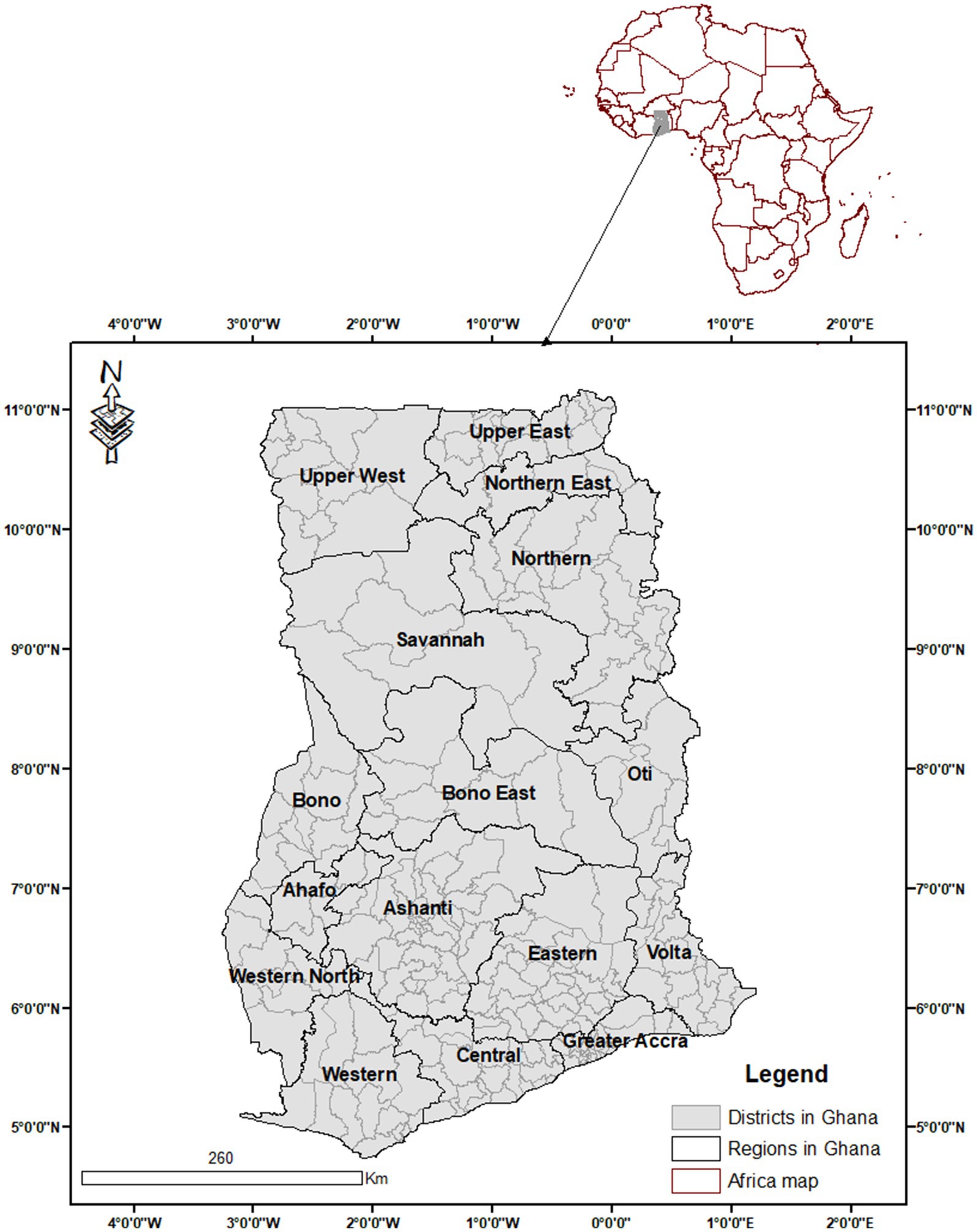
Figure 1. Map of the districts, regions, and the national boundary of Ghana within Africa.
The area of the country is 238,533 km2, which encompasses a diverse environment that can be classified into two main vegetation groups: the tropical forest zone (comprising Wet evergreen, Moist evergreen, Upland Evergreen, Moist Semi-Deciduous, and Dry Semideciduous, which constitute approximately 44% of the land area) and the savannah (comprising of Transition, Guinea Savannah, Sudan Savannah, and Coastal Savannah, constituting about 56% of the land area) (Hall and Swaine, 1981; Wagner and Cobbinah, 1993). The High Forest Zone, which comprises evergreen and semi-deciduous forests, is dominated by agroforests with tree crops such as cocoa, coffee, oil palm, rubber, and kola, whereas farmed parklands are composed of shea butter tree (Butyrospermum parkii) and the West African locust bean or dawadawa (Parkia clappertoniana) are found in Guinea savannah (Cook and Grut, 1989). Other farm parklands found in Sudan savannah comprise Acacia albida (Faidherbia albida) or gao, which is common to farmers and herdsmen alike.
2.2 Data source
Global land use land cover (LULC) datasets were downloaded from ESRI Land Cover products (Karra et al., 2021). The 10 m global land cover map was produced by a collaboration of Impact Observatory, ESRI, and Microsoft. This data was derived from the European Space Agency (ESA) Sentinel-2 imagery at 10 m resolution. The data for each year were produced using deep learning Artificial Intelligence (AI) land classification from Impact Observatory, a technology company based in the United States. This algorithm is used to train billions of human-labeled image pixels from the National Geographic Society (Karra et al., 2021). The algorithm is applied to the Sentinel-2 Level-2A image collection on Microsoft’s Planetary Computer, processing over 400,000 Earth observations per year to finally generate global maps. Land use land cover types were predicted for nine separate classes generated from this model for each year. The nine classes include Built-up areas, Crops, Trees, Water, Rangeland, Flooded Vegetation, Snow/Ice, Bare Ground, and Clouds. All the classes are found in Ghana except Snow/Ice. Trees are defined as any significant clustering of tall (~15 feet or higher) dense vegetation, typically with a closed or dense canopy, and this includes wooded vegetation, clusters of dense, tall vegetation within savannas, plantations, swamp, or mangroves (Karra et al., 2021). This study was selected from 2017 to 2023 because they are the only years with data available for this model.
This study selected the ESRI landcover data because of its free, open-source data and the 10 m resolution, which is finer than other global data available. ESRI landcover data has been reported to have the highest overall accuracy of 75% as compared to Google’s Dynamic World (72%) and ESA’s World Cover (65%) using global ground truth data with a minimum mapping unit of 250 m2, and it was able to also accurately map land use classes such as trees at 81%, crops at 78%, and built-up areas at 83% (Venter et al., 2022).
The forest reserves map (ESRI shapefile) in Ghana was downloaded from https://www.protectedplanet.net/country/GHA (UNEP-WCMC and IUCN, 2023). This polygon was used to generate another polygon for all the areas outside forest reserves in Ghana.
2.3 Data preprocessing and change detection
Preprocessing of the acquired data was performed using Geographic Information System (GIS) tools used in this study. They were ArcGIS 10.8 (ESRI, Redlands, CA), Quantum Geographic Information System (QGIS) 3.36 MOLUSCE plugin, and TerrSet Land Change Modeller. The LULC data were reprojected from World Geodetic System 1984 (WGS84) to Universal Traverse Mercator (UTM) Zone 30 N, and the study region was extracted using ArcGIS 10.8. LULC class for trees was extracted using the conditional (con) tool from the Spatial Analyst tools in ArcGIS 10.8. This tree raster map was used to extract forest reserves map and trees outside forests map. Both forest reserves raster and trees outside forest reserves raster were generated by using the Extract by Mask Tool in ArcGIS with inputs from the tree raster and forest reserve and TOF polygons. These two raster data were mosaicked into a new raster along with the seven remaining LULC classes using the Mosaic To New Raster Tool in ArcGIS to replace trees in the LULC final map. The final LULC classes include Water (1), Trees outside forests (2), Trees in forests (3), Flooded vegetation (4), Crops (5), Built area (7), Bare ground (8), Clouds (10), and Rangeland (11). The LCM (Land Change Modeler) embedded in the TerrSet Geospatial Monitoring and Modeling System (TGMMS) software was used to estimate spatiotemporal changes between 2017 and 2023.
2.4 Future LULC simulation
We utilized the Modules for Land-Use Change Simulation (MOLUSCE) plugin inside QGIS to compute and project the future landcover map in 2030 using the research interval (2017–2023) and generated one LULC change map. The Multi-Layer Perception (MLP)–Cellular Automata–Artificial Neural Network (CA-ANN) algorithm within the MOLUSCE plugin was used to project future landcover changes. The MOLUSCE plugin offers functionalities, including the generation of a transition probability matrix, which involves the CA-ANN approach and simulation-based modeling with several techniques such as Logistic Regression, Multi-Criteria Evaluation, Weights of Evidence, and ANN. Estimating and predicting future LULC patterns is the final stage of simulation using the CA model. The CA model considers the discrete nature of space, time, and state variables while simulating the complex interplay of time and space.
Digital Elevation Model (DEM) data from National Aeronautics and Space Administration DEM (NASADEM) (NASA JPL, 2021) slope, which was generated from the DEM using the Slope tool in Spatial Analyst Tool in ArcGIS, distance to roads (downloaded as a shapefile from the OpenStreetMap), rivers, and waterways (downloaded from HydroSHEDS) were considered as independent factors. In contrast, the dependent factors were the LULC data from 2017 to 2021. Pearson’s correlation within the plugin was used to assess the correlation between the geographic parameters in the two raster images, which is used to examine the association among spatial components. The projection of the LULC map for 2023 was established using variables such as iterations (5000), neighborhood (1), momentum (0.010), hidden layer (5), and learning rate (0.005) from the CA-ANN method in this study. CA-ANN model is used to calibrate, simulate, and predict the LULC. The validation of simulated LULC (2023) was done with the actual LULC (2023) map, and different coefficients such as correctness coefficient, overall kappa coefficient, historical kappa coefficient, and local kappa coefficient were calculated. The same approach was used to validate the LULC (2030) map. The validation module in the MOLUSE plugin was used for the validation process. The kappa coefficient assesses the overall agreement between the classification and prediction, given a random arrangement. Historical kappa value for each class shows the level of understanding for that class between the observed and predicted rasters, whereas local kappa coefficient evaluates the ability of the model to locate objects accurately.
3 Results
3.1 Land use change and TOF
Changes were observed in all the different LULC types in Ghana between 2017 and 2023 (Figure 2). Overall, rangeland had the largest area of LULC in Ghana from 2017 to 2023, whereas bare ground had the least (Figures 2, 3). TOF decreased from 91,029 km2 in 2017 to 80,658 km2 in 2023, with a difference of −10,371 km2 and a percentage change of −4.35% between these 2 years. However, trees inside forests increased from 24,754 km2 to 25,478 km2. The difference was 724 km2, with a percentage increase of 0.30% between 2017 and 2023. Trees inside forests declined from 2018 to 2022, but increased in 2023.
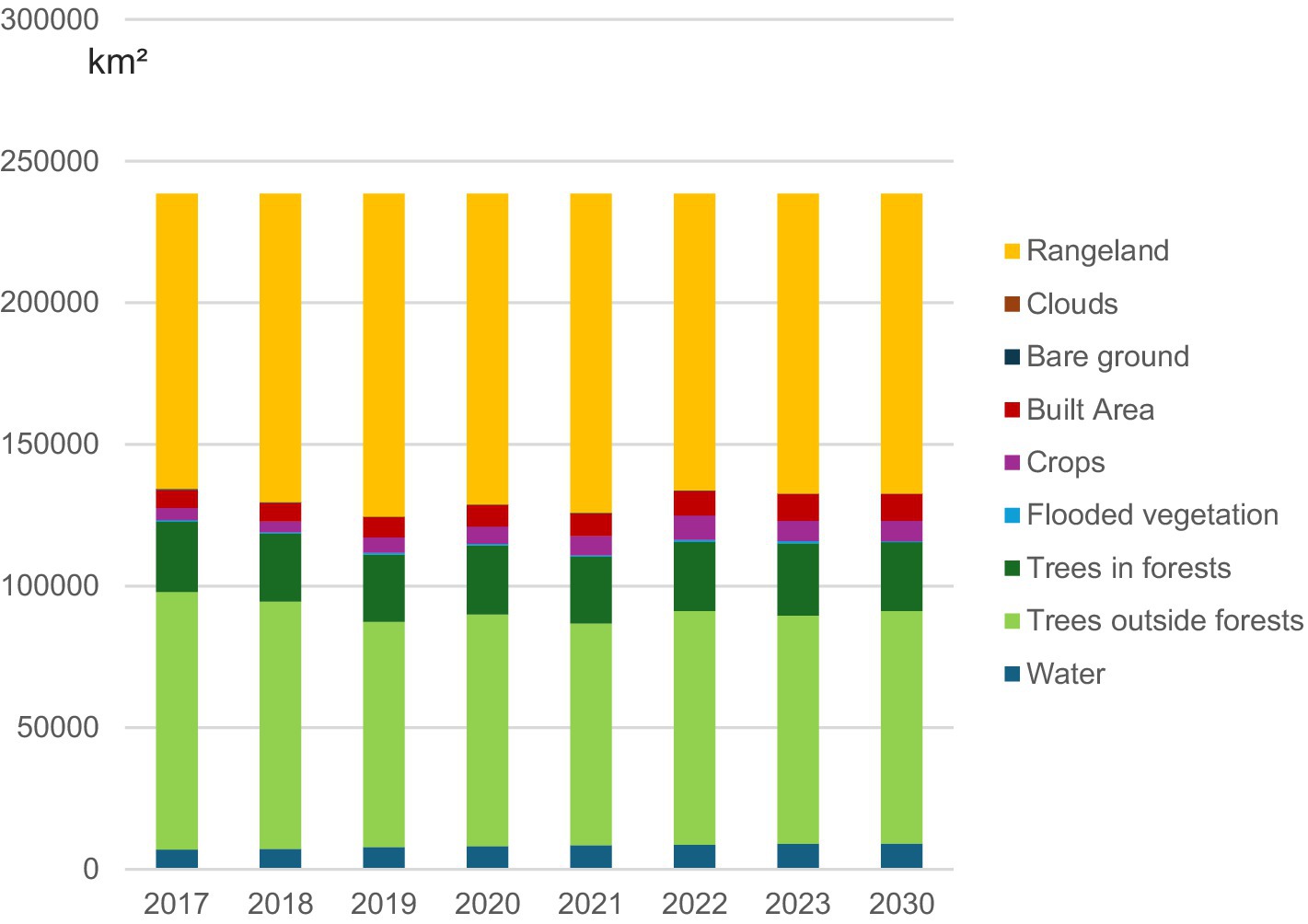
Figure 2. Area of the different land uses in Ghana for past and future years.
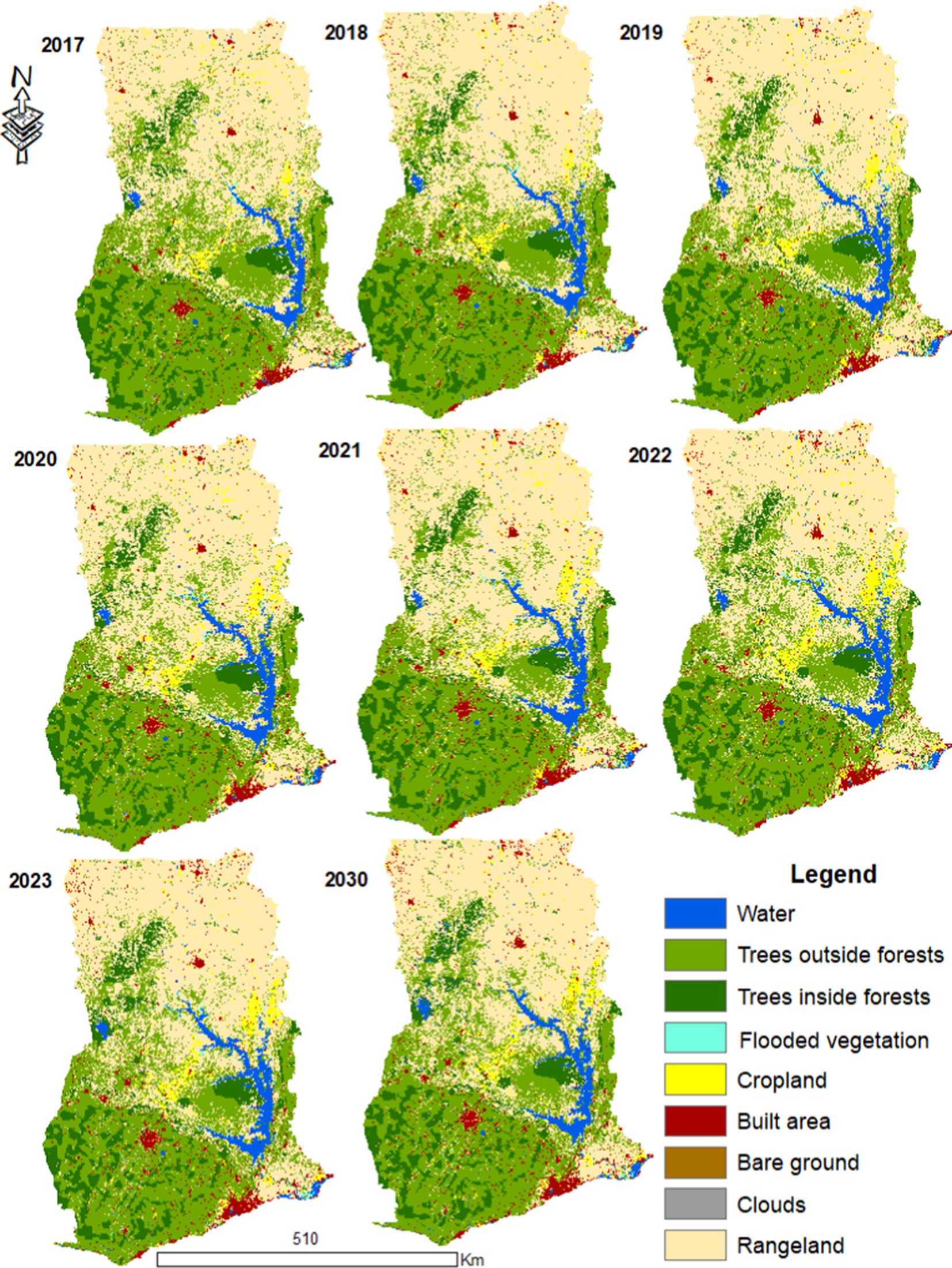
Figure 3. Land use land cover maps of Ghana for past years and future projections for 2030.
For TOF, a general decline was observed for all the years, but the largest was in 2021 (32.8% of the total area of Ghana), whereas the year 2017 had 38.2% of the total area.
The highest reduction for all the different LULC types in Ghana was observed in TOF between 2017 and 2023, as shown in Figures 4, 5. The main conversions from one LULC type to the other with more than 1,000 km2 reveal that TOF had the highest expansion in area after rangeland (Figure 4). However, the loss of TOF was more significant, and this caused the overall decrease in TOF, although there was a high increase in TOF during the research interval (Figure 5). This decline was caused by the expansion of rangeland at the expense of TOF at 16286 km2. Additionally, built-up areas and croplands contributed to the general reduction of TOF in Ghana during the research interval at 1,321 km2 and 1,221 km2, respectively.
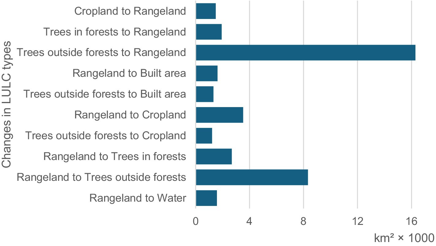
Figure 4. Changes of more than 1,000 km2 in the different LULC types in Ghana between 2017 and 2023.
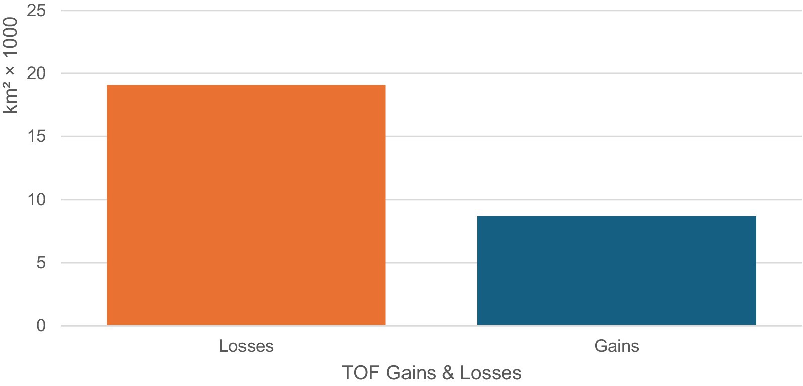
Figure 5. Total gains and losses of TOF in Ghana between 2017 and 2023.
3.2 TOF within the districts and regions of Ghana
TOF were found in all the regions of Ghana, but there were different percentages between 2017 and 2023 (Figure 6; Table 1). Ashanti region had the largest area of TOF in Ghana, whereas the Upper East region had the least (Figure 6). Figure 7 shows the zoomed-in portion of the LULC maps for Ashanti region between 2017 and 2023. TOF is the main LULC type in the Ashanti region, and they occupy almost the whole region (Figure 7). Eastern and Western regions showed higher areas of TOF, whereas Greater Accra and North East regions also showed lower areas of TOF (Table 1; Figure 6). Generally, all the regions showed declines in TOF during the study period. The highest decrease in TOF between 2017 and 2023 was observed in the Bono East region, but Western and Western North regions revealed increases in all years except for 2023, which showed a slight decrease in TOF (Table 1). TOF decreased in Bono East region in 2021 and 2022 at −5,215 km2 (−5.73%) and − 4,973 km2 (−5.46%), respectively. The highest increase in TOF in the Western region was observed in 2018 and 2022 at 469 km2 (0.51%) and 721 km2 (0.79%), respectively.
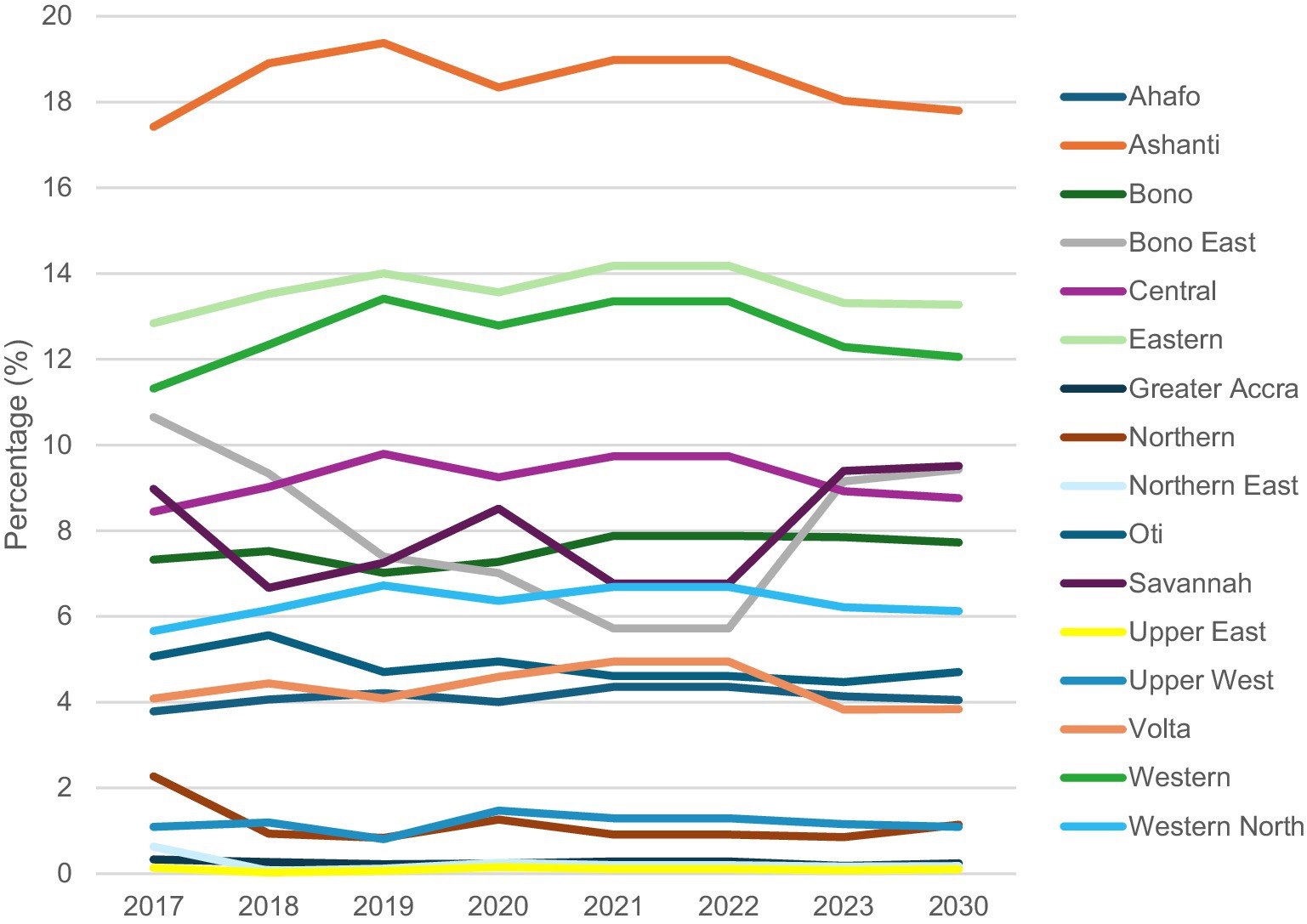
Figure 6. Percentage of trees outside forests for each region in Ghana for past and future years.
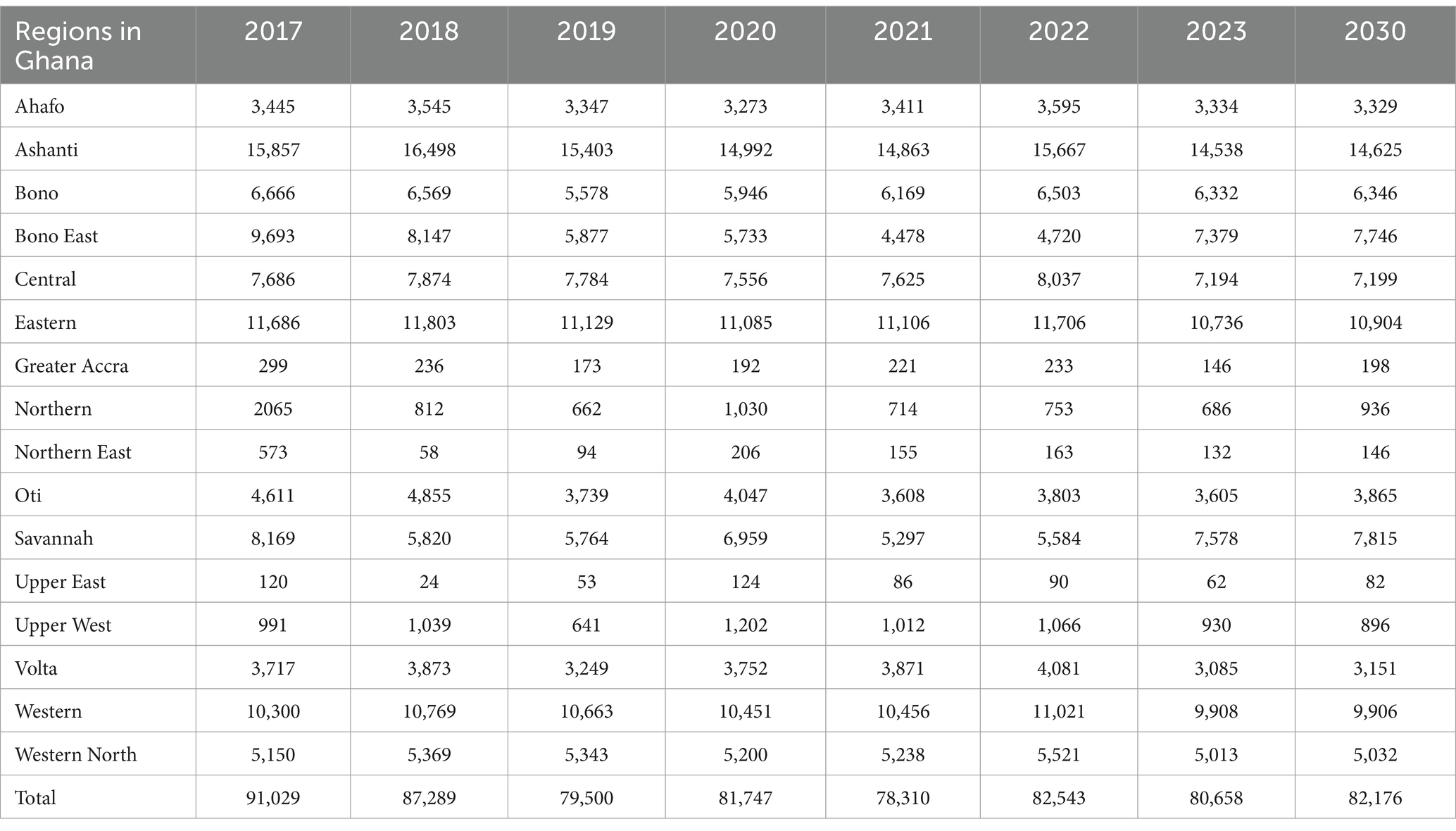
Table 1. Area of trees outside forests for each region in Ghana for past and future years in square kilometers.
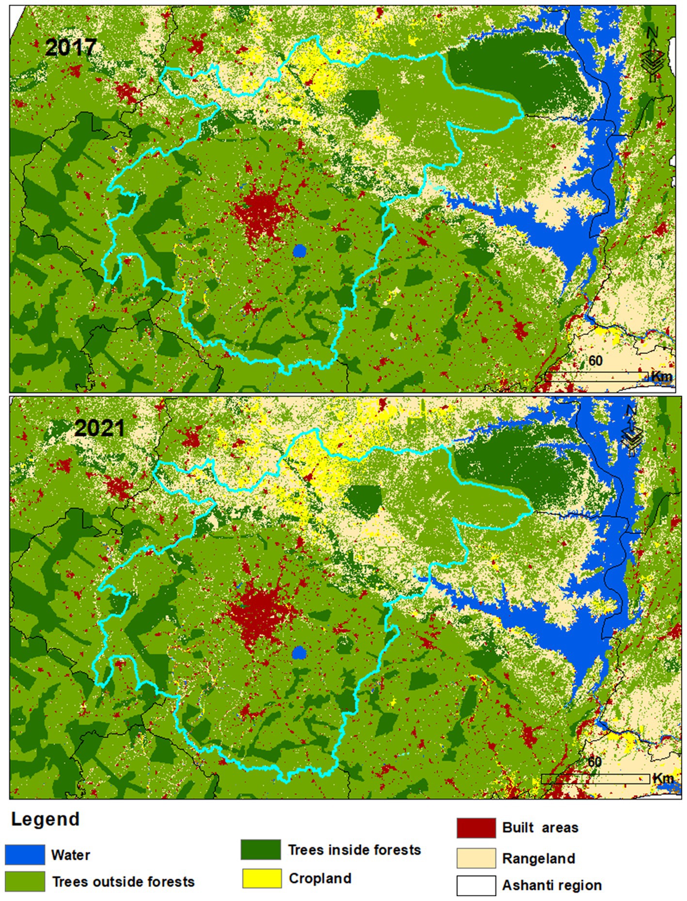
Figure 7. Zoom zone of the changes in LULC in the Ashanti region between 2017 and 2023.
The distribution of TOF within the districts of Ghana between 2017 and 2023 is shown in Figure 8. The districts within the central and western parts of Ghana had the highest distribution of TOF during the research interval. Certain districts in Ghana did not have any TOF between 2017 and 2023, with the majority found in the Greater Accra region. This includes Accra Metropolis, Ablekuma West Municipal, Ayawaso Central Municipal, Ayawaso East Municipal, and Ayawaso North Municipal. The district in Ghana with the largest area of TOF was found in Sekyere Afram Plains North. Several other districts in Ghana have larger areas of TOF, such as Kintampo North Municipal, Bole, Central Gonja, and Kwahu Afram Plains South. Districts with the least area of TOF in Ghana were Ablekuma Central Municipal, Ablekuma North Municipal, Ashaiman Municipal, Bolga East, Bolgatanga Municipal, Pusiga, Old Tafo Municipal, Tema West Municipal, Ledzokuku Municipal, Krowor Municipal, and Korle Klottey Municipal. Between 2017 and 2023, Kintampo North Municipal showed the highest decline in TOF in 2021 (−1342.6 km2), whereas Bole showed the highest increase in TOF in 2023 (434.1 km2). This decrease in TOF is clearly seen in Figure 9, which shows a zoomed-in portion of TOF in Kintampo North Municipal between 2017 and 2021.
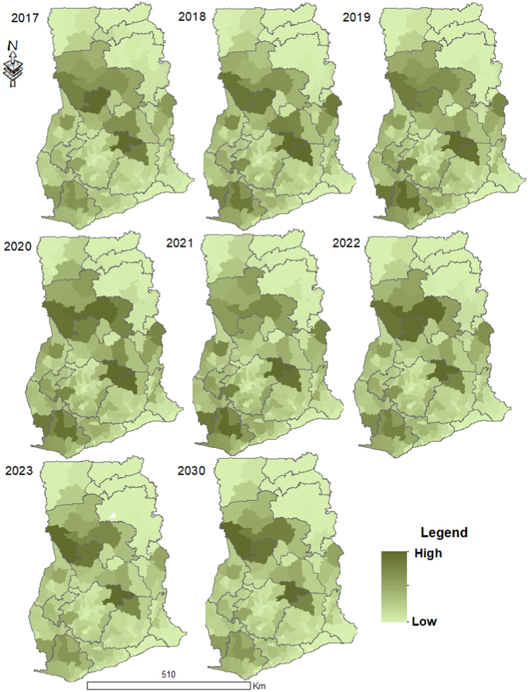
Figure 8. Area of trees outside forests within all the districts in Ghana for past and future years.
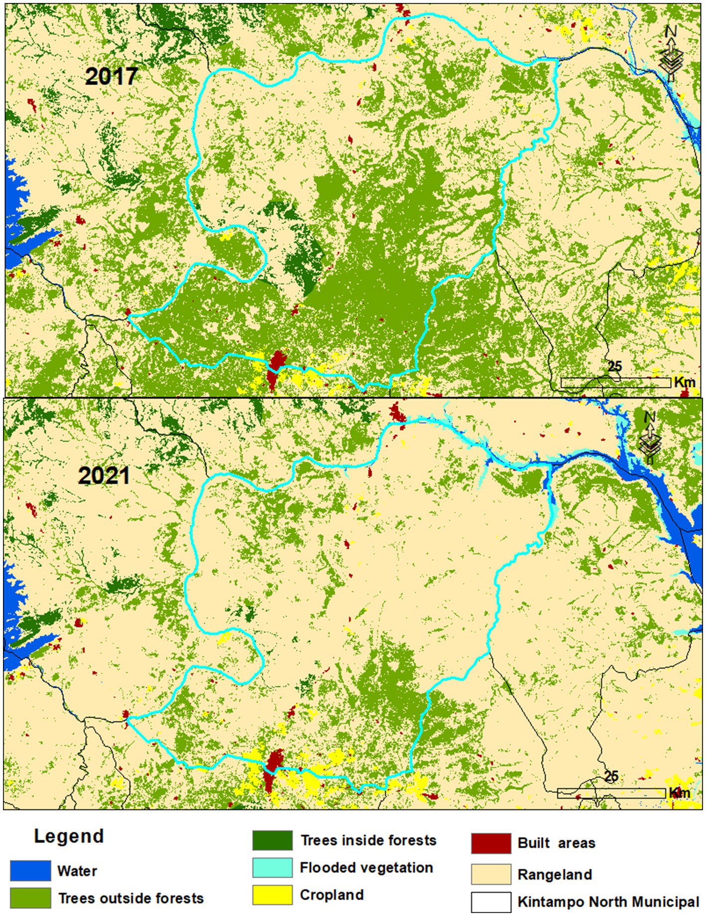
Figure 9. Zoom zone of changes in LULC in the Kintampo North Municipality (Bono East region) between 2017 and 2021.
3.3 Future land use change of TOF in Ghana
The future projection of LULC in Ghana is shown in Figures 3, 2. Changes were observed in all the different LULC types in 2030, with an increase in half and a decrease in the other half. The highest expansion was observed in built-up areas (3,131 km2, 1.31%), and the highest decline was observed in TOF (−8,853 km2, −3.71%). Trees inside forests are expected to decrease in 2030 by −446 km2 at −0.19%. TOF will decrease in all the regions in Ghana by 2030. Ashanti region will still have the largest area of TOF in Ghana at 17.8%, followed by Eastern and Western regions at 13.3 and 12.1%, respectively (Figure 6). However, these three regions will see a general decline in TOF between 2023 and 2030 (Figure 6). Upper East and Greater Accra regions will have the least area of TOF in Ghana at 0.1 and 0.2% by 2030. Districts showing the largest areas of TOF in 2030 are Sekyere Afram Plains North, Bole, and Kintampo North Municipal at 2779.5 km2, 2149.5 km2, and 1948.7 km2, respectively. However, Korle Klottey Municipal and Old Tafo Municipal showed the least area of TOF at 0.0 km2. Atebubu Amantin district showed the highest decline (472.3 km2) in TOF, as shown in Figure 10. The highest expansion of TOF in 2030 was found in Bole (438.6 km2).
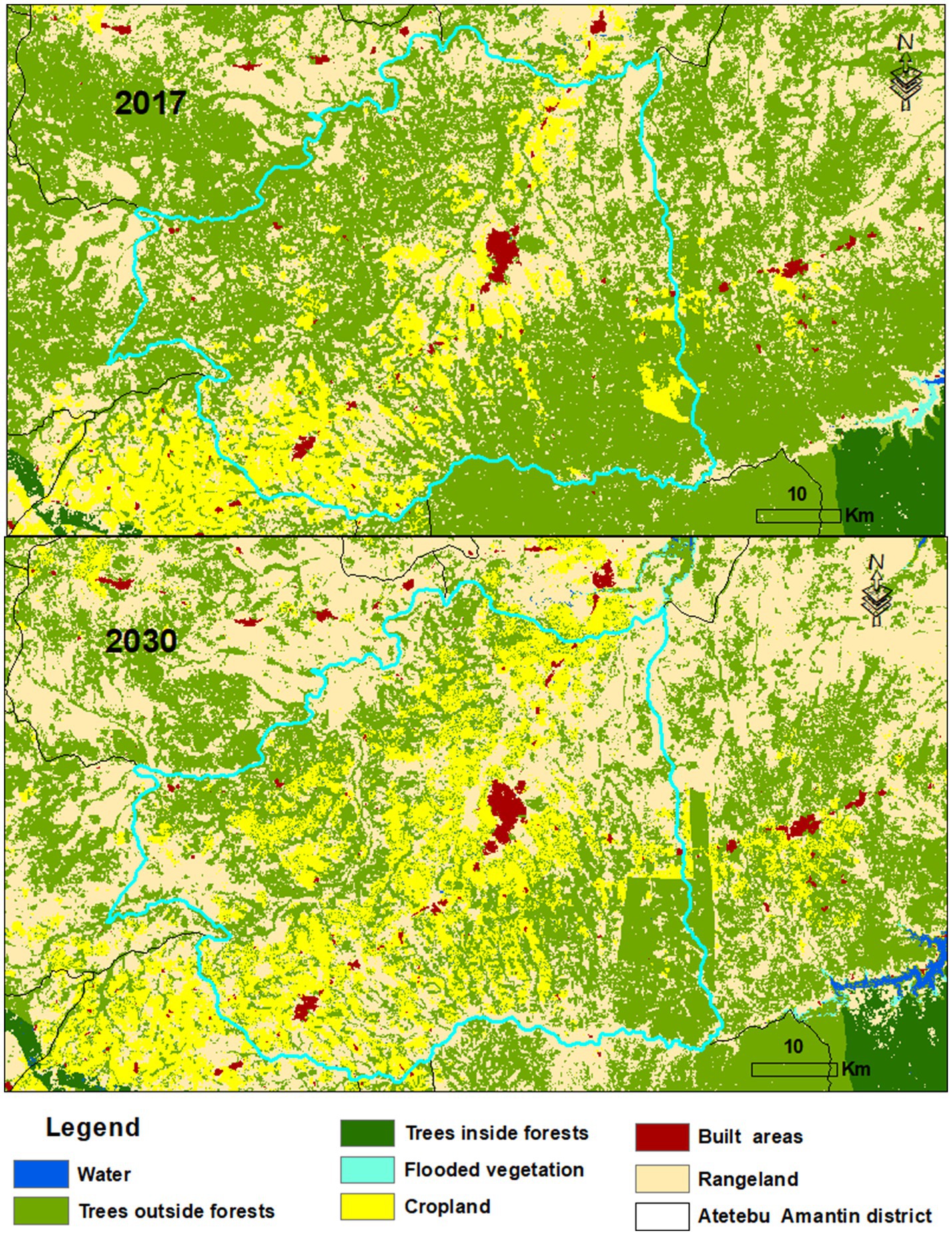
Figure 10. Zoom zone of changes in LULC in the Atebubu Amantin district (Bono East region) between 2017 and 2030.
3.4 Model validation of projected LULC
The projected LULC map generated from the MOLUSCE plugin was validated for the year 2023 in this study. The results of the different kappa statistics of the simulated and observed LULC for 2023 are presented in Table 2.
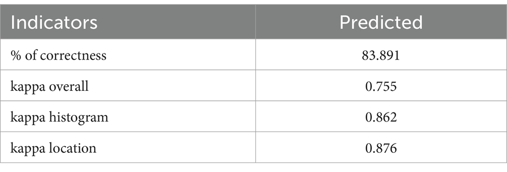
Table 2. Kappa coefficient of LULC predicted (2023).
The validation period showed % of correctness, kappa overall, kappa histogram, and kappa location at 83.891, 0.755, 0.862, and 0.876, respectively. All the kappa coefficients were either very close to or above 80%, which is the acceptable criteria, and this supports the fact that the accuracy was adequate for predicting future LULC (Alam et al., 2021; Kamaraj and Rangarajan, 2022). Overall, the model was ideally fitting for projecting LULC for 2030 due to the comparable percentages for the surge and decline in the study area. A transition matrix, which presents the relative quantity of pixels that shift from one classification to the other, was generated (Table 3), and it shows the quantification of LULC variations between the starting year (2017) and the ending year (2021). It calculates the probability of the transition and area change based on the LULC data and variables that stimulate changes in LULC. The stability of a LULC type is represented by values in the diagonal that are close to 1. Water and built areas were the most stable LULC types, with probabilities of 0.98 and 0.96, respectively. TOF had a lower probability (0.76) compared to trees in forests (0.88) and rangeland (0.87). The rows and columns represent LULC categories in the first and final years, respectively. Bare ground, rangeland, flooded vegetation, and crops contributed 0.082, 0.057, 0.04, and 0.036 to the transition to TOF, respectively (Table 3). Generally, this study shows that built areas and trees inside forests were stable due to rapid urbanization and conservation efforts, respectively, whereas TOF and bare ground gave a larger proportion to other LULC types because they are being threatened.
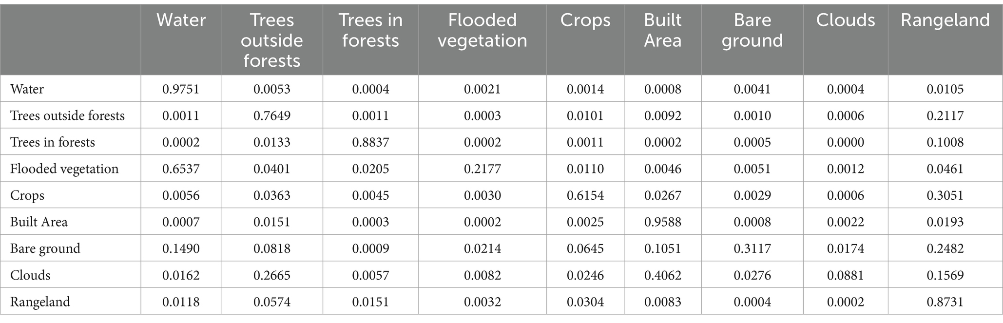
Table 3. Transition matrix for LULC maps from 2017 to 2021.
4 Discussion
4.1 Past and future changes of TOF in Ghana
There is a general decline in TOF in Ghana, and this is expected to continue at a faster rate. The annual change rate of TOF in Ghana is −2.02% and is expected to decrease by −0.79% by 2030. This is similar to other studies that reported a decline in TOF. Plieninger and Schaar (2008) reported a regression of TOF in Spain between 1956 and 2003, whereas Gibbons et al. (2008) predicted a decline in trees in agricultural landscapes in the next 90–180 years across different countries. Trees inside forests have improved and will continue to improve as compared to TOF in Ghana. This is because of the conscious efforts made by the government and forest fringe communities to protect these reserves. TOF does not have that kind of protection because they have not yet been recognized as important to the wellbeing of Ghanaians. The decline in TOF in Ghana happened as a result of improvement in rangeland, cropland, and built-up areas within the country. These major LULC types are competing with TOF and reducing their extent in Ghana. TOF has the largest area in Ghana apart from rangeland and this is expected to continue in the future even though there is a general decline in TOF in Ghana. The main constituent of TOF in Ghana is agroforestry, which is practiced in different ways. It is estimated that the off-reserve which forms part of TOF in Ghana comprises farmlands (48%, mainly agroforests), fallow lands (26%), natural forests (12%), grasslands (8%), secondary forests (3%), and others (2%) (Otutei, 2018). Leh et al. (2013) reported that agroforests declined between 2000 and 2009 from 40.47 to 38.16%, even though there was an increase from 2005 to 2009. Our results also showed increases in 2020 and 2022, but there was a general decline in TOF between 2017 and 2023 in Ghana. Novotný et al. (2017) reported an increase in TOF between 1953 and 2014 in the Czech Republic, and Plieninger (2011) also reported a substantial increase of 24.8% of farm trees and woodlands in Eastern Germany between 1964 and 2008. The decline in TOF could possibly be a result of timber harvests, particularly within the secondary forests and agricultural landscapes in Ghana (Oduro et al., 2014).
This study has shown that TOF will be faced with tremendous decline in the next few years in Ghana, which calls for policies to be implemented to preserve them. One of the ways to preserve TOF is to focus on cocoa agroforestry in Ghana. Cocoa agroforestry has been promoted over the years, with farmers being guided to plant shade trees on their farms, constituting a major part of TOF in Ghana. Blaser et al. (2018) concluded that keeping 30% of shade cover in cocoa farms improves biodiversity and climate change adaptation and mitigation. Cocoa farmers in Ghana need to be encouraged to keep shade trees on their farms, and stakeholders in the cocoa industry should provide a payment of ecosystem services for these farmers to promote the sustainability of TOF in Ghana. The context of social forestry and the role of TOF for rural livelihoods should also be considered as another way to preserve TOF in Ghana. For example, in Niger, there was a farmer-driven massive increase of trees on farmlands which caused an equally significant improvement in livelihood (Beckschäfer et al., 2017). This can also be adopted in some rural communities in Ghana where TOF are dominant to improve livelihood.
4.2 TOF in the regions and districts of Ghana
Our study has shown that the Ashanti region and Sekyere Afram Plains North, one of the districts in these regions, had the highest percentage of TOF in Ghana, whereas other regions such as Western, Western North, and Eastern also had high percentages of TOF. These regions are situated in the high forest zone where cocoa agroforestry is practiced with shade trees found in most of the farms in these regions. For instance, a study done by Appiah (2013) revealed that an average of 21 trees per hectare was located in an off-reserve in the Sekyere Afram Plains district of Ghana. Cocoa agroforestry is the way forward to preserving TOF in Ghana, and any decline in shade trees in cocoa farms will cause a decrease in TOF. These cocoa-growing areas are the same areas where TOF is dominant in Ghana, which this study has highlighted.
Therefore, policymakers and decision-making bodies should focus their attention on these regions to mitigate the decline in TOF and provide sustainable management practices to preserve TOF.
The other forms of agroforestry, such as oil palm plantations mostly found in the Eastern and parts of Ashanti regions and rubber trees dominant in the Western region, must be protected and encouraged because they form a major part of TOF in Ghana.
This study showed that the Greater Accra and Northeast regions of Ghana had the least TOF in Ghana and four districts, including Accra Metropolis, Ayawaso Central Municipal, Ayawaso East Municipal, and Ayawaso North Municipal, which are in the Greater Accra region, had almost no TOF. TOF in Kumasi Metropolis and several districts within the Greater Kumasi, which is the second largest urban area in Ghana, declined over the years, albeit with lower levels of shrinkage compared to the Greater Accra region. This is because Greater Kumasi has managed to maintain some of its farmlands, although there is an expansion of built-up areas and a decline in open and closed forests (Koranteng et al., 2023). Greater Accra region and Greater Kumasi are highly urbanized areas with huge population densities. This study shows that a massive expansion in built-up areas and a reduction of agroforestry systems are the two main factors leading to the decline in TOFs in regions and districts. Rapid population growth and urbanization are the main drivers of TOF depletion in the major cities in Ghana (Addae and Oppelt, 2019). Preference to single tenancy type of housing has gained ascendency in the major cities compared to old traditional multiple tenancy type of housing, also known as compound housing, which is gradually losing its dominance in Ghana, leading to a decline in TOF. This is partly due to the growing number of middle class and the influence of the Western culture on the educated class in Ghana. This research is useful for urban planners who want to incorporate TOF in urban development.
4.3 Implications of changes of TOF in Ghana
The study has shown the need for the preservation of TOF in Ghana and its importance to the economy of Ghana. This research has given evidence of the general status of TOF in Ghana and shown that they are equally important to trees inside forests due to the size of their area in Ghana. The protection of TOF in Ghana can be the path toward the achievement of conservation and sustainable use of biodiversity. The Aichi Target 11 specified the conservation of TOF, thus highlighting the significance of trees outside formal forests and protected areas (Peros et al., 2022). TOF can also be another path toward the AFR100 (The African Forest Landscape Restoration Initiative), which has a goal of restoring 100 million hectares of deforested and degraded landscapes across Africa by 2030 (WRI, 2015).
Several conservation policies overprioritize the protection of trees inside forests and protected areas (Ravindranath et al., 2014), and this is common in Africa and Ghana. This situation is similar to TOF in Europe, where they are often overlooked with the exception of the United Kingdom, which has conducted a systematic assessment of their resources (Brewer et al., 2017). Many reports from other studies have shown a global increase in tree cover on agricultural lands in the last decade, and this expansion will continue in future (Song et al., 2018; Zomer et al., 2009). It has become evident that TOF are the way forward toward climate change adaptation and mitigation, as well as biodiversity conservation, and our attention has to be shifted toward TOF now and in future. The mortality rates of tropical forests are projected to augment, whereas disturbance agents such as drought, fire, insects, and pathogens are also projected to further threaten the future of tropical forests (McDowell et al., 2018; Seidl et al., 2017). This study shows that TOF has the highest share of forest lands in Ghana and should be given great attention. Public awareness of TOF should be intensified to ensure the collective efforts to preserve TOF in Ghana.
Despite their importance, TOF in Ghana face several challenges, including land-use changes, deforestation, and lack of formal recognition in environmental policies. Addressing these challenges requires comprehensive research and inclusive policies that acknowledge the value of TOF and promote their sustainable management. Recent advances in remote sensing and AI-enabled data processing have enabled more accurate mapping of TOF, providing valuable insights for climate change mitigation and adaptation policies. The National Forest Monitoring and Assessment (NFMA) programme of FAO offers a unique possibility to study TOF resources, which should be implemented in Ghana and other West African countries.
In the socioeconomic context, farmers should be engaged in decision-making on TOF in Ghana because they have more lasting and direct impact on the preservation of TOF. The socioeconomic benefits of TOF for the farmers are enormous, and many of them would want to promote its sustainability. However, the land tenure and compensation conflicts between farmers and the government prevent some farmers from promoting TOF sustainability because the latter has criminalized the selling or harvesting of trees on farms without a permit from the Forestry Commission (Appiah, 2013). This has caused many of the farmers to engage in illegal activities such as illegal chainsaw logging to derive benefits from the trees (Acheampong and Marfo, 2011). The effect of this is the decrease in trees on farms, their shade density and diversity (Anglaaere et al., 2011; Dawoe et al., 2016), provoking a decline in TOF.
Future research should focus on developing integrated land-use strategies that promote the conservation and sustainable management of TOF. This includes enhancing the capacity of local communities to manage TOF, promoting agroforestry practices, and integrating TOF into national and regional climate change mitigation strategies. By recognizing the multifaceted contributions of TOF, we can develop policies that support environmental sustainability and human wellbeing in Ghana.
5 Conclusion
TOF are supposed to be acknowledged by governments in Africa at the national scale, and efforts are to be made to integrate them into national forest assessments due to their importance to the ecology and economy of countries in Africa, particularly Ghana. In this study, we assessed the status of TOF in Ghana, their distribution, and their future projection. TOF occupy a significant place as the second largest area among different LULC types in Ghana and has the largest area of trees in Ghana. However, the current state of TOF in Ghana shows that they are diminishing due to the expansion of rangeland, cropland, and built areas in Ghana. The cocoa-growing regions in Ghana have larger portions of TOF, whereas the big cities either have the least TOF or are declining drastically. This trend is expected to continue in the future if proper attention is not taken. Cocoa agroforests in the high forest zone and farm parklands of dawadawa and shea trees in the savannah zone of Ghana should be considered as TOF rather than just farms. This will facilitate the preservation of TOF and promote their contribution to biodiversity conservation and climate change mitigation and adaptation in Ghana. The awareness of TOF in Ghana created in this study should lead to the next step of establishing a national assessment and reporting framework.
Data availability statement
The original contributions presented in the study are included in the article/supplementary material, further inquiries can be directed to the corresponding author.
Author contributions
KK: Conceptualization, Formal analysis, Investigation, Methodology, Software, Writing – original draft, Writing – review & editing.
Funding
The author(s) declare that no financial support was received for the research and/or publication of this article.
Conflict of interest
The author declares that the research was conducted in the absence of any commercial or financial relationships that could be construed as a potential conflict of interest.
Generative AI statement
The authors declare that no Gen AI was used in the creation of this manuscript.
Publisher’s note
All claims expressed in this article are solely those of the authors and do not necessarily represent those of their affiliated organizations, or those of the publisher, the editors and the reviewers. Any product that may be evaluated in this article, or claim that may be made by its manufacturer, is not guaranteed or endorsed by the publisher.
References
Acheampong, E., and Marfo, E. (2011). The impact of tree tenure and access on chainsaw milling in Ghana. Ghana J. Forestry 27, 68–86. https://fornis.net/sites/default/files/documents/tree_tenure.pdf (Accessed March 16, 2024).
Addae, B., and Oppelt, N. (2019). Land-use/land-cover change analysis and urban growth modelling in the Greater Accra metropolitan area (GAMA), Ghana. Urban Sci. 3:26. doi: 10.3390/URBANSCI3010026
Affum-Baffoe, K. (2009). Timber resources outside permanent forest estates of Ghana high forest zone: status and trends. In strengthening off-reserve timber management in Ghana. Workshop Proc. 7, 6–15. https://www.tropenbos.org/file.php/40/final%20proceedings%207 (Accessed March 16, 2024).
Ahmed, P. (2008). Trees outside forests (TOF): a case study of wood production and consumption in Haryana. Int. For. Rev. 10, 165–172. doi: 10.1505/ifor.10.2.165
Alam, N., Saha, S., Gupta, S., and Chakraborty, S. (2021). Prediction modelling of riverine landscape dynamics in the context of sustainable management of floodplain: a geospatial approach. Ann. GIS 27, 299–314. doi: 10.1080/19475683.2020.1870558
Anglaaere, L. C. N., Cobbina, J., Sinclair, F. L., and McDonald, M. A. (2011). The effect of land use systems on tree diversity: farmer preference and species composition of cocoa-based agroecosystems in Ghana. Agrofor. Syst. 81, 249–265. doi: 10.1007/S10457-010-9366-Z/METRICS
Appiah, M. (2013). Tree population inventory, diversity and degradation analysis of a tropical dry deciduous forest in Afram Plains, Ghana. For. Ecol. Manag. 295, 145–154. doi: 10.1016/J.FORECO.2013.01.023
Armson, D., Stringer, P., and Ennos, A. R. (2013). The effect of street trees and amenity grass on urban surface water runoff in Manchester, UK. Urban For. Urban Green. 12, 282–286. doi: 10.1016/J.UFUG.2013.04.001
Arnberger, A. (2012). Urban densification and recreational quality of public urban green spaces—a Viennese case study. Sustain. For. 4, 703–720. doi: 10.3390/SU4040703
Asare, R., Afari-Sefa, V., Osei-Owusu, Y., and Pabi, O. (2014). Cocoa agroforestry for increasing forest connectivity in a fragmented landscape in Ghana. Agrofor. Syst. 88, 1143–1156. doi: 10.1007/S10457-014-9688-3/METRICS
Beckschäfer, P., Schnell, S., and Kleinn, C. (2017). “Monitoring and Assessment of Trees Outside Forests (TOF),” in Agroforestry. eds. J. C. Dagar, V. P. Tewari et al. (Singapore:Springer Singapore), 137–161.
Bellefontaine, R., Petit, S., Pain-Orcet, M., Deleporte, P., and Bertault, J.-G. (2002). Trees outside forests: towards better awareness. Rome:FAO, 235 p. (FAO Conservation Guides, 35).
Blaser, W. J., Oppong, J., Hart, S. P., Landolt, J., Yeboah, E., and Six, J. (2018). Climate-smart sustainable agriculture in low-to-intermediate shade agroforests. Nat. Sustain. 1, 234–239. doi: 10.1038/s41893-018-0062-8
Brewer, A., Ditchburn, B., Cross, D., Whitton, E., and Ward, A. (2017). Tree cover outside woodland in Great Britain—Summary report. Forestry Commission: Edinburgh, UK.
Buchel, S., and Frantzeskaki, N. (2015). Citizens’ voice: a case study about perceived ecosystem services by urban park users in Rotterdam, the Netherlands. Ecosyst. Serv. 12, 169–177. doi: 10.1016/J.ECOSER.2014.11.014
Chakravarty, S., Pala, N. A., Tamang, B., Sarkar, B. C., Manohar, K. A., Rai, P., et al. (2019). “Ecosystem services of trees outside forest” in Sustainable Agriculture, Forest and Environmental Management. eds. M. Jhariya, A. Banerjee, R. Meena, D. Yadav (Singapore: Springer).
CILLS (2016). Landscapes of West Africa–a window on a changing world. United States: US geological survey EROS.
Cook, C., and Grut, M. (1989). Agroforestry in sub-Saharan Africa: A farmer’s perspective. Available online at:https://www.cabidigitallibrary.org/doi/full/10.5555/19900642392
Dasgupta, R., Basu, M., Hashimoto, S., Estoque, R. C., Kumar, P., Johnson, B. A., et al. (2022). Residents’ place attachment to urban green spaces in greater Tokyo region: an empirical assessment of dimensionality and influencing socio-demographic factors. Urban For. Urban Green. 67:127438. doi: 10.1016/J.UFUG.2021.127438
Dawoe, E., Asante, W., Acheampong, E., and Bosu, P. (2016). Shade tree diversity and aboveground carbon stocks in Theobroma cacao agroforestry systems: implications for REDD+ implementation in a west African cacao landscape. Carbon Balance Manag. 11, 1–13. doi: 10.1186/S13021-016-0061-X/TABLES/7
Estoque, R. C., Murayama, Y., and Myint, S. W. (2017). Effects of landscape composition and pattern on land surface temperature: an urban heat island study in the megacities of Southeast Asia. Sci. Total Environ. 577, 349–359. doi: 10.1016/J.SCITOTENV.2016.10.195
Gibbons, P., Lindenmayer, D. B., Fischer, J., Manning, A. D., Weinberg, A., Seddon, J., et al. (2008). The future of scattered trees in agricultural landscapes el futuro de árboles dispersos en paisajes agrícolas. Conserv. Biol. 22, 1309–1319. doi: 10.1111/J.1523-1739.2008.00997.X
Hall, J., and Swaine, M. (1981) in Distribution and ecology of vascular plants in a tropical rain forest: forest vegetation in Ghana. ed. J. Werger. 1st ed (Dr W Junk Publishers, Springer Dordrecht).
Hansen, C. P., Pouliot, M., Marfo, E., Obiri, B. D., and Treue, T. (2015). Forests, timber and rural livelihoods: implications for social safeguards in the Ghana-EU voluntary partnership agreement. Small-Scale Forestry 14, 401–422. doi: 10.1007/S11842-015-9295-9/METRICS
Kamaraj, M., and Rangarajan, S. (2022). Predicting the future land use and land cover changes for Bhavani basin, Tamil Nadu, India, using QGIS MOLUSCE plugin. Environ. Sci. Pollut. Res. 29, 86337–86348. doi: 10.1007/S11356-021-17904-6/METRICS
Karra, K., Kontgis, C., Statman-Weil, Z., Mazzariello, J. C., Mathis, M., and Brumby, S. P. (2021). “Global land use / land cover with Sentinel 2 and deep learning,” 2021 IEEE International Geoscience and Remote Sensing Symposium IGARSS. Belgium, 4704–4707.
Koranteng, A., Adu-Poku, I., Frimpong, B. F., Asamoah, J. N., Agyei, J., Zawiła-Niedźwiecki, T., et al. (2023). Urbanization and other land use land cover change assessment in the greater Kumasi area of Ghana. J. Geosci. Environ. Protec. 11, 363–383. doi: 10.4236/GEP.2023.115022
Leh, M. D. K., Matlock, M. D., Cummings, E. C., and Nalley, L. L. (2013). Quantifying and mapping multiple ecosystem services change in West Africa. Agric. Ecosyst. Environ. 165, 6–18. doi: 10.1016/J.AGEE.2012.12.001
Long, A. J., and Nair, P. K. R. (1999). Trees outside Forests: Agro-, Community, and Urban Forestry. New Forests, 17, 145–174. doi: 10.1023/A:1006523425548
McDowell, N., Allen, C. D., Anderson-Teixeira, K., Brando, P., Brienen, R., Chambers, J., et al. (2018). Drivers and mechanisms of tree mortality in moist tropical forests. New Phytol. 219, 851–869. doi: 10.1111/NPH.15027
Novotný, M., Skaloš, J., and Plieninger, T. (2017). Spatial-temporal changes in trees outside forests: case study from the Czech Republic 1953–2014. Appl. Geogr. 87, 139–148. doi: 10.1016/J.APGEOG.2017.07.005
Oduro, K. A., Mohren, G. M. J., Affum-Baffoe, K., and Kyereh, B. (2014). Trends in timber production systems in the high forest zone of Ghana. Int. For. Rev. 16, 289–300. doi: 10.1505/146554814812572458
Otutei, E. (2018). Sustaining off-reserve forests in Ghana: A game-theoretic approach. Adelaide, South Australia: The University of Adelaide.
Peros, C. S., Dasgupta, R., Estoque, R. C., and Basu, M. (2022). Ecosystem services of ‘trees outside forests (TOF)’ and their contribution to the contemporary sustainability agenda: a systematic review. Environ. Res. Commun. 4:112002. doi: 10.1088/2515-7620/ac9d86
Plieninger, T. (2011). Capitalizing on the carbon sequestration potential of agroforestry in Germany’s agricultural landscapes: realigning the climate change mitigation and landscape conservation agendas. Landsc. Res. 36, 435–454. doi: 10.1080/01426397.2011.582943
Plieninger, T., and Schaar, M. (2008). Modification of land cover in a traditional agroforestry system in Spain: processes of tree expansion and regression. Ecol. Soc. 13:25.
Ravindranath, N., Murthy, I. K., Priya, J., Upgupta, S., Mehra, S., and Nalin, S. (2014). Forest area estimation and reporting: implications for conservation, management and REDD. Curr. Sci. 106, 1201–1206. https://www.jstor.org/stable/24102335 (Accessed March 16, 2024).
Regmi, B. N., and Garforth, C. (2010). Trees outside forests and rural livelihoods: a study of Chitwan District, Nepal. Agrofor. Syst. 79, 393–407. doi: 10.1007/S10457-010-9292-0/TABLES/7
Seidl, R., Thom, D., Kautz, M., Martin-Benito, D., Peltoniemi, M., Vacchiano, G., et al. (2017). Forest disturbances under climate change. Nat. Clim. Chang. 7, 395–402. doi: 10.1038/nclimate3303
Smeets, E. M. W., and Faaij, A. P. C. (2007). Bioenergy potentials from forestry in 2050: an assessment of the drivers that determine the potentials. Clim. Chang. 81, 353–390. doi: 10.1007/S10584-006-9163-X/METRICS
Song, X. P., Hansen, M. C., Stehman, S. V., Potapov, P. V., Tyukavina, A., Vermote, E. F., et al. (2018). Global land change from 1982 to 2016. Nature 560, 639–643. doi: 10.1038/s41586-018-0411-9
Thomas, N., Baltezar, P., Lagomasino, D., Stovall, A., Iqbal, Z., and Fatoyinbo, L. (2021). Trees outside forests are an underestimated resource in a country with low forest cover. Sci. Rep. 11, 1–13. doi: 10.1038/s41598-021-86944-2
UNEP-WCMC and IUCN (2023). Protected planet: The world database on protected areas (WDPA). Cambridge, UK: UNEP-WCMC and IUCN.
Venter, Z. S., Barton, D. N., Chakraborty, T., Simensen, T., and Singh, G. (2022). Global 10 m land use land cover datasets: a comparison of dynamic world, world cover and ESRI land cover. Remote Sens. 14:4101. doi: 10.3390/rs14164101
Wagner, M., and Cobbinah, J. (1993). Deforestation and sustainability in Ghana: the role of tropical forests. J. For. 91, 35–39. doi: 10.1093/jof/91.6.35
WRI. (2015). African Forest Landscape Restoration Initiative (AFR100) | World Resources Institute. Available online at:https://www.wri.org/initiatives/african-forest-landscape-restoration-initiative-afr100. Accessed 13 Jan 2024
Yadav, Y., Chhetri, B., Raymajhi, S., Tiwari, K., and Kumar, B. (2017). Importance of trees outside forest (TOF) in Nepal: a review. Octa J. Environ. Res. 5, 70–81. http://www.sciencebeingjournal.com/sites/default/files/01_0502_YY.pdf (Accessed March 16, 2025).
Keywords: TOF, ESRI global landcover, MOLUSCE, GIS, Ghana
Citation: Kusi KK (2025) Trees outside forests in Ghana: current state, spatial distribution, and future projection. Front. For. Glob. Change. 8:1540910. doi: 10.3389/ffgc.2025.1540910
Edited by:
Antonio Santoro, University of Florence, ItalyReviewed by:
Nuria Torrescano, El Colegio de la Frontera Sur, MexicoZhongqian Cheng, Peking University, China
Copyright © 2025 Kusi. This is an open-access article distributed under the terms of the Creative Commons Attribution License (CC BY). The use, distribution or reproduction in other forums is permitted, provided the original author(s) and the copyright owner(s) are credited and that the original publication in this journal is cited, in accordance with accepted academic practice. No use, distribution or reproduction is permitted which does not comply with these terms.
*Correspondence: Kwadwo Kyenkyehene Kusi, a2t1c2lAY3Npci1mb3JpZy5vcmcuZ2g=