CB
christian bignami
National Institute of Geophysics and Volcanology (INGV)
Roma, Italy
83
Total downloads
4,537
Total views and downloads
Submit your idea
Select the journal/section where you want your idea to be submitted:
Manuscript Submission Deadline 30 April 2026
This Research Topic is currently accepting articles.
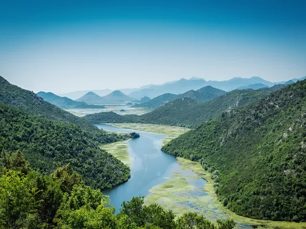
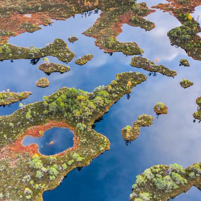
The conservation of healthy and active peatlands and the restoration of degraded peatlands is now a global priority. It is well-know that peatlands cover about the 3% of Earth’s land surface but, despite this very limited land area, they can store approximately one-third of Earth’s soil carbon. Because of the present climate change effects, they are becoming vulnerable to drainage and drying, and consequently are also exposed to wildfires resulting in large carbon emissions. Restoring the functionalities of a peatland ecosystem is a challenging task because degradation impacts on different interconnected components such as the peat body, the hydrology, and the vegetation cover. In such a complex environment, remote sensing data from space, aircrafts or drones, represents a valuable tool to monitor peatlands and provide a comprehensive view of the ongoing degradation phenomena or restoration activities.
The proposed Research Topic aims to collect state-of-the-art and new works that deal with remote sensing (RS) for monitoring the health status of peatlands. The collection should focus on the ability of RS data and techniques, collected by satellite, aircraft or unmanned aerial vehicles (UAVs) to provide new or added value products also by integrating remote sensing data with ground and in-situ information. Contributions based on data acquired at different scales and resolutions, by passive and/or active sensors, such as hyper- and multi-spectral sensors and Synthetic Aperture Radar (SAR), or by using multi-sensor data-fusion methods, are very welcome. Special emphasis is expected on multi-temporal analysis, data mining and artificial intelligence approaches for the exploitation of large image datasets. In this context, new works are encouraged to address new insights and deeper understanding on the potentialities and main limitations of Earth observation imageries, in particular, towards the exploitation of the current large dataset of satellite images, and how passive and active sensors (e.g. multi-spectral and Synthetic Aperture Radar - SAR) can be integrated for generating new and more robust peatland health indices, also focusing on the critical issue of their validation and calibration.
This Research Topic welcomes Original Research submission addressing, but not limited to, the following applications:
• Peatland condition and degradation monitoring;
• Peatland restoration efficacy;
• Monitoring of factors driving degradation;
• Soil moisture, vegetation and crop mapping;
• Land motion, land cover and land use change; and
• Carbon storage and proxy measures of greenhouse gas fluxes.
We would like to acknowledge Yara Al Sarrouh has acted as coordinator and has contributed to the preparation of the proposal for this Research Topic.
Topic editor Gerardo Lopez-Saldana and Topic Coordinator Yara Al Sarrouh are employed by Assimila Ltd. All other Topic Editors declare no competing interests with regards to the Research Topic subject.
This Research Topic accepts the following article types, unless otherwise specified in the Research Topic description:
Articles that are accepted for publication by our external editors following rigorous peer review incur a publishing fee charged to Authors, institutions, or funders.
Keywords: Peatlands, Wetlands, Remote Sensing, Multi-spectral, Hyper-spectral, SAR, InSAR, Monitoring
Important note: All contributions to this Research Topic must be within the scope of the section and journal to which they are submitted, as defined in their mission statements. Frontiers reserves the right to guide an out-of-scope manuscript to a more suitable section or journal at any stage of peer review.
Manuscripts can be submitted to this Research Topic via the main journal or any other participating journal.
Submit your idea
Select the journal/section where you want your idea to be submitted: