Abstract
Volcanological observatories have common needs and often common practical issues for multi-disciplinary data monitoring applications. Real-time access to integrated data, technical metadata, modeling and estimation of uncertainties are fundamental for an efficient interpretation. But in fact, the heterogeneity of instruments or acquisition systems and the inherent problems to produce rapid models using real-time data lead to difficulties that may hinder crisis management. In an attempt to globally address these questions, the French volcanological and seismological observatories have developed a specific operational software system over the past 19 years. Based on GNU/Linux open source tools and a Web interface, the WebObs system mainly offers: (1) a modular database for equipment network management; (2) a dozen of evolving dedicated periodic tasks for each monitoring technique like seismology, deformations and geochemistry that use standard data formats with automated execution of periodic tasks that produce high-quality graphs on preset moving time intervals, data exports, optional event notifications including e-mail alerting, instruments status controls based on their data validity; (3) web-form interfaces for manual data input/editing and export; (4) a user request form to adjust the tasks parameters for a single execution and to produce customized graphs and data exports. This system hence constitutes a web-based tool that performs integrated, centralized and automated real-time volcano monitoring. It has therefore become a strong support for data analysis and exchange between researchers, engineers, and technicians during periods of unrest as well as periods of long-term quiescence. WebObs is also widely open for development of interdisciplinary modeling and enhanced data processing. This allows scientists to test new methods with real-time data flux and to instantaneously share their results in the community.
1. Introduction
Any operational volcano observatory faces the complex mission of: (1) detecting changes in the behavior of the volcano through the acquisition of continuous as well as periodic long time-series of instrumental observations produced by multidisciplinary techniques in real-time as much as is possible; (2) quantifying and monitoring the spatio-temporal dynamics of those changes with respect to parameter and process critical thresholds; (3) assessing the short-term potential hazard for the population; and (4) informing the authorities and the population of the state of activity of the volcano and the potential hazards. This implies a good understanding of natural phenomena, i.e., through the use of interpretative models, ideally with quantitative physical parameters like seismic energy, pressure source depth, fluid composition and thermodynamics or potential eruptive volumes. Although today this quantitative approach is still strongly limited by our current knowledge of complex non-linear volcanic processes and their uncertainties, volcanological fundamental research anchored in high-resolution observations and monitoring data provides a framework to continuously improve this knowledge. A volcano observatory hence constitutes a unique environment where fundamental and applied sciences must coexist and where academic researchers necessarily have to intimately collaborate with engineers and technicians to correctly interpret the observations.
But in the real world, during phases of volcanic unrest as well as periods of long-term quiescence, observatories have to face common practical issues for multi-disciplinary data monitoring applications. Indeed, accessing to integrated data in real-time and estimating uncertainties are fundamental tasks to achieve in order to guarantee efficient interpretation and decision making. However, the variety of instruments, the wide range of data sampling, the heterogeneity of acquisition systems and the challenges and constraints of technical maintenance lead to practical difficulties that may hinder efficient and timely crisis management. Moreover, during unrest, scientists must produce manually interpretative models that should ideally use data in real-time. Only few hours of delay in the updating of data processing can generate interpretations that might have serious consequences.
On the other hand, researchers that have developed new ideas and models might want to finally apply them on real-time data in order to contribute to observatory task in addition to other standard monitoring methods. Testing models on real-time data may be also a robust way to validate them. But this implementation is not straightforward if the monitoring system has not been designed at an early stage for integrating new modules that use the input and output data streams.
Furthermore, a volcanological observatory must record the activity of one or more volcanoes for very long periods of time. Beyond the preservation of scientific measurements and observations, an observatory is a structure that must transmit a lot of information of different kinds to the people who work there and elsewhere in collaboration. The centralization and the perpetuation of these scientific, technical and administrative data is a long-term challenge because the actors of observatories need to access rapidly and in a user-friendly interface to past knowledge and data; a task that turns out to be fundamental in case of crisis management, for example.
To address the needs of real-time data monitoring and long-term research in such a context, most observatories have developed their own dedicated solutions. Some are focused on single scientific method while others are concentrated on access to data through a global database. Noteworthy among these are the pioneer software PC-BOB for time series data management (Murray, 1990), μGRAPH utility for data analysis (Beauducel, 1998), FFM software for eruption forecasting (Cornelius and Voight, 1995), VALVE system for multidisciplinary database (Cervelli et al., 2002, 2011), SWARM tool for real-time seismic data streams (Cervelli et al., 2004), dMODELS software package for supervised deformation modeling (Battaglia et al., 2013), and the WOVODat platform for worldwide volcanic unrests datasets (Newhall et al., 2017).
In the French volcanological and seismological observatories which are responsible for La Soufrière de Guadeloupe, La Montagne Pelée, Piton de la Fournaise and recently the new Mayotte submarine volcano, we have developed since late 2000 an operational system named WebObs (WO) that attempts to address these common questions in the context of a generic pluri-instrumental volcanological and seismological observatory (Beauducel and Anténor-Habazac, 2002; Beauducel et al., 2004, 2010; Beauducel, 2006).
2. Materials and Methods
2.1. Ambivalence Between Research and Monitoring
Researches that use observations of natural phenomena must lead to a gradual characterization of a conceptual model of physical, chemical, and geological processes. During crisis management, operational scientific advisories (i.e., forecast) have to be based on the real-time observations through the use of such an interpretative model, in a context that leaves no time to spend on fundamental research. Thus, any instrumental network in an observatory has, besides the apparently unique objective of monitoring, a second implicit objective which is to constrain and maintain up-to-date conceptual models.
Figure 1A shows this approach using the example of ground deformations study: here the model is for instance the hypothetic location of the magma reservoir. Used as an a priori information, scientists implement a GNSS network optimized to detect any pressure changes at depth, then they perform the measurements at the surface, process the raw data to compute displacements, search for source models that are consistent with the data, interpret the results in terms of a new plausible depth, and finally confirm or re-assess the initial location of the magma reservoir. A single loop of this experiment might take months or years, and each of the different steps is important and must be undertaken while keeping in mind the overall purpose of improving the model toward a better quantitative representation of reality. Figure 1B transposes this long-term research cycle in general terms adapted to any scientific domain that uses instrumental data or observations.
Figure 1
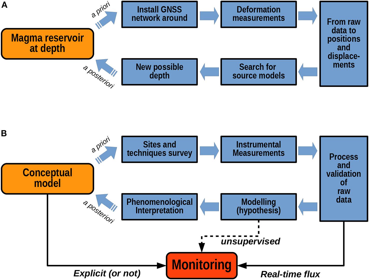
Long-term research and real-time monitoring coexistence for instrumental approach in observatories. (A) Shows an example of long-term research cycle for volcano ground deformation studies, (B) extends the concept to any scientific method. The monitoring is using real-time validated data and the current phenomenological model to interpret them. Dashed arrow places the automatic unsupervised modeling as a new tool for monitoring.
The action of monitoring is not such a separated task in this framework. Using validated data in real-time, monitoring also constitutes an interpretation of the data through the current conceptual model. Any volcano monitoring service uses an interpretative conceptual model, explicitly or not: an experimented scientist looking at time series on a screen is using his own interpretative model in his mind to make the raw data meaningful. An automatic system that could produce real-time unsupervised modeling with clearly identified hypothesis would help scientists in achieving their tasks by providing a rational, structured, accountable and quantitative framework to interpret the data.
2.2. Objectives
The overall objective of WO is to design an integrated operational tool, through a centralized web-based interface, that addresses most of the observatory daily needs from technical management to scientific analysis of real-time data even with quantitative modeling. In fact, especially during a crisis management, scientists must have a broad and exhaustive view of the whole acquisition chain, in order to correctly evaluate the effective uncertainty of any observations, especially when the results are not straightforward if an anomaly is detected in the data. In order to accomplish these goals, we propose a system with the following specifications:
instant access to raw and processed data, to quantitative parameters from unsupervised data modeling, all techniques, and over any time period in real-time and/or upon request;
access to all technical characteristics of the acquisition systems, as metadata, including to equipment maintenance data that may affect a measurement;
a unique level of information, technical, scientific and operational, shared with all the people involved;
a robust, efficient, and light standalone system open for development and fast integration of new multidisciplinary data streams and innovative monitoring methods.
2.3. Strategy and Pragmatic Solutions
In order to reach these objectives, elegant overall solutions obviously exist but they rely on extensive technical means and long-term investment particularly in the case of: (1) building a single, huge, multidisciplinary new database for all the data; (2) upgrading all sensors, telemetry and acquisition systems to make them homogeneous in standard data formats; (3) making automatic the manual measurements, when technically possible; and finally (4) using a large computer to process any user's requests without delay. Thus, in the project we have discarded from the beginning the perspective of structurally reforming existing overall solutions and opted for the development of a more pragmatic and less costly solution.
The strategy that we have proposed has been efficient on the short-term in order to:
keep existing acquisition systems and data archives as they are,
connect and make accessible all data in their native formats, even though we promote standard formats and protocols since WO has implemented many,
process the data through dedicated scheduled tasks to anticipate the most common real-time requests,
facilitate manual data edition and access through simple text databases.
2.3.1. Technical Specifications
WO can run on a single computer server under the GNU/Linux operating system on IA-32 (i386) or x86-64 architectures. It is an installable package of bash scripts and using a combination of several languages: Perl and Javascript for the web interface, Matlab standalone binaries (no license needed), Python and some C binaries for the data processings, but any other Linux-compatible language are compatible welcome.
In account of the obvious heterogeneity of acquisition systems, data formats and the specificity of data archiving in every observatory, we decided that for automatic systems WO should not recreate a database of existing monitoring data but will be able to read the raw data in their native format, on-the-fly, adapting itself to existing archives or data streams. This concept is consistent with real-time needs but had also the advantage to not impose extensive data conversion or migration to observatories. Presently, the available data formats include seismological standards for waveforms and hypocenters (SEED, Earthworm, Hypo71, FDSN web-services, QuakeML, …), GNSS solutions (Gipsy, Gamit/GlobK, …), some data loggers (Campbell Sci.), any delimiter-separated values files, and customisable SQL requests. New data formats can be easily added with little development. Data export of validated data or any processing results is made in simple text format (delimiter separated values).
However, observatories also still have to deal with manual data besides automatic acquisitions, such as the results of chemical analysis of water or gas samples, laser distance measurements, data from geophysical surveys (e.g., gravimetry, electrical resistivity, spontaneous potential, magneto-telluric). Due to very low sampling rate, these data account for a negligible size of storage but they still are of primary importance and must be equally considered in the monitoring system. WO proposes few web-form interfaces to input/edit and export this kind of data, and each are associated to a dedicated process to also produce automatic graphs, in the same way as high sampling rate automatic methods.
Although there are some internal databases in sqlite3 format for the system management itself, most of the system uses text files for configuration parameters and symbolic links under a basic folders architecture, easy to edit or share with other systems.
WO provides a web portal using a HTTP server for the graphical user interface and web services, and provides user authentication associated with an extended resources access management. WO can be used as an internal web portal, and/or connected to the internet for external access, restricted or even public. But the main goal is to be able to run standalone, even under offline internet conditions. This aim leads to voluntarily limit the use of any external internet services.
The web pages use a customizable menu with sub-menus using HTML and CSS facilities. The welcome page contains fixed areas with customizable content: a title banner, an information area, a news area, an extract of agenda events. Additional free text-content web pages can be created and accessed through the main menu. All text zones can use the MarkDown syntax.
One of the main tools of WO is a modular databank to manage information on site measurements, stations, sensors, any equipment or observations. The proposed network architecture can be adapted to various objects with a very broad concept of what is metadata: interactive maps, log history, customizable features, photos, documents. Any object can be linked to some data channels, data processing, manual web-form editing, and any feature can be linked to the features of an object. The network management can handle any type of multidisciplinary method, permanent or temporary experiments, instrumental or not (i.e., a journal of observations or activity).
Geolocation and network maps are usually a good base for discussion. WO will automatically produce individual maps of stations or sites using global digital elevation models (DEM) downloaded when necessary and stored locally. This allows to have up-to-date offline maps available at any time. Background maps are built using an automatic merge of SRTM and ETOPO1 global topography files, or any user defined DEM. Coordinates are defined in latitude and longitude in the WGS84 referential, and will be automatically converted to UTM and cartesian ECEF, with text file and KML export facilities.
For the data processing, we have adopted a near real-time solution which consists of producing static images (PNG and EPS formats), automatically updated by periodic tasks under control of a dedicated jobs scheduler. Pre-set moving time windows are defined for each method, from hours to decades, so all the standard graphs are instantaneously accessible for users, without additional server solicitation. User manual requests of any other time interval are available at any time but will have lower priority than periodic tasks.
For historical reasons, the most advanced data processing modules have been written in the Matlab language, a choice justified by the native matrix computing capabilities perfectly suited to signal processing, numerical modeling, inverse problem and high-quality graphical outputs. Take note of the fact that no license is needed since these modules have been compiled in standalone and freely distributable binaries. Source codes are also available for development, running under compatible free environment like GNU Octave, or translation to other languages. Note that the job scheduler is able to run any GNU/Linux compatible program or code. Besides the Matlab library, a package of bash functions is available to import WO parameters into any external programs.
2.3.2. Relational Structure
2.3.2.1. Nodes
WO relational structure is built around one basal element named a “node.” A node is an object with a list of characteristics, mostly optional, all user-editable: name, alias (short name), lifetime dates, geographical location, text-content user-defined features that can be linked to other node(s), sensor(s) and channels description (calibration file), data processing related format and parameters, radio transmission path, photos, documents, dated events and sub-events with additional images and links to features and channels, text-content project. In practice, a node can be, while this is not an exhaustive list:
an instrumental multi-parameter station,
a measurement or sampling site,
a mobile equipment,
spare parts of an equipment,
a journal of observations,
a description of historical event like an eruption.
Some examples of nodes, associated features and possible documents and events content are given in Table 1 and Figure S4.
Table 1
| Node | Features | Documents | Events |
|---|---|---|---|
| Instrumental Station | Acquisition | ||
| Sensor |
User's manual |
||
| Power |
Sensor's calibration |
Maintenance log | |
| Infrastructure | |||
| Transmission | |||
| Mobile Equipment | Description | User's manual | Calibration |
| Protocole | Maintenance log | ||
| Sampling Site | Infrastructure | – | Sampling log |
| Protocole | Site layout | ||
| Volcanic Eruption | VEI | ||
| Seismicity |
Data |
||
| Deformations |
Technical Reports |
Chronology |
|
| Gas |
Scientific Papers |
||
| Deposits | |||
| Casualties | |||
| Journal of Observations | – | Press release | Observations |
| Testimonies | |||
| Building | Description | ||
| Furniture | |||
| Land |
Any related |
Maintenance log | |
| Equipments | Inspection | ||
| Vehicles | |||
| Staff |
Example of nodes, associated feature list (any of them can be linked to an other node), types of documents and events.
The list is non-exhaustive and completes the common characteristics of any node which are: name, alias, type, lifetime, coordinates, installation, access, information, photos and schemes.
2.3.2.2. Grids and domains
Nodes can be combined into a “grid,” a higher level object of WO. There are 3 types of grids:
a “view” is a simple group of nodes for display purposes, like a network of stations or sites, that will produce a table list, location maps, and descriptive text-contents (purpose, references, dated events). Association or disassociation of nodes to a view is immediate and will produce easy customizable lists and maps.
a “proc” is a group of nodes for dedicated data processing purpose. It has the same characteristics as a view, but in addition has the capacity of producing graphs and data export, as a periodic task and/or upon user request, through a generic processing named a “superproc” (see the detailed list in section 3.2). Association or disassociation of nodes to a proc has immediate incidence on data processing outputs.
a “form” is a manually editable small database, adapted to non-automatic data acquisitions. A form has a table data display with search parameters, editable form inputs with value checking, data export, and can be linked to a proc to produce automatic graphs.
Views and procs are associated with a “domain,” a higher level object to group several grids into general categories, mainly for retrieval and display purposes. Default domains are Seismology, Deformation, Geochemistry, Geophysics, Imagery, Phenomenology, and Acquisition. This list is fully customizable, for example: domains can be a list of different volcanoes. Examples are given in Tables S1, S2.
A global search tool allows to find any event contents in all grids and nodes.
2.3.2.3. Users, groups and authorizations
WO uses its own authorization system in addition to the HTTP server authentication, to identify its users and control their individual access level to WO resources (e.g., files, processes, web pages, etc).
Users can be managed individually and/or as members of groups. A user or group is given an explicit access level to a given resource. Possible access levels are “admin” (full control including creation and deletion), “edit” (modifiable) or “read” (only readable). Lack of access level for a resource means no access to this resource; there is no explicit restriction level concept.
Default groups provided on first installation are: ADMIN, DUTY, OBSERVER, VISITOR with adapted and editable resource access levels. The main web menu can be extended by user or group individual menus that will appear only for the corresponding user or group.
2.3.2.4. The gazette
Management of the time schedule of an observatory team is one of the pillars of work efficiency, while activity archives are very useful to make reports. Since its creation in 2001, WO includes a shared agenda named The Gazette, that provides such observatory's logbook and calendar functions. It can be considered as a collection of timestamped and categorized articles. Default pre-defined categories are: Duty Scientist, Staff Missions, Off/Holiday, Field work, Meeting/Officials, Medias, Outreach, Teaching, Visitors, Students Training, Buildings, Miscellaneous. An option allows to include node's and grid's events. The Gazette is fully customizable, including the definitions of local day-off dates, and exportable.
Each category is considered as a resource and can be associated to specific access level for user/group. For example, access to staff leaves of absence data can be restricted to superiors.
Figure 2 resumes the WO structure, objects and links between them.
Figure 2
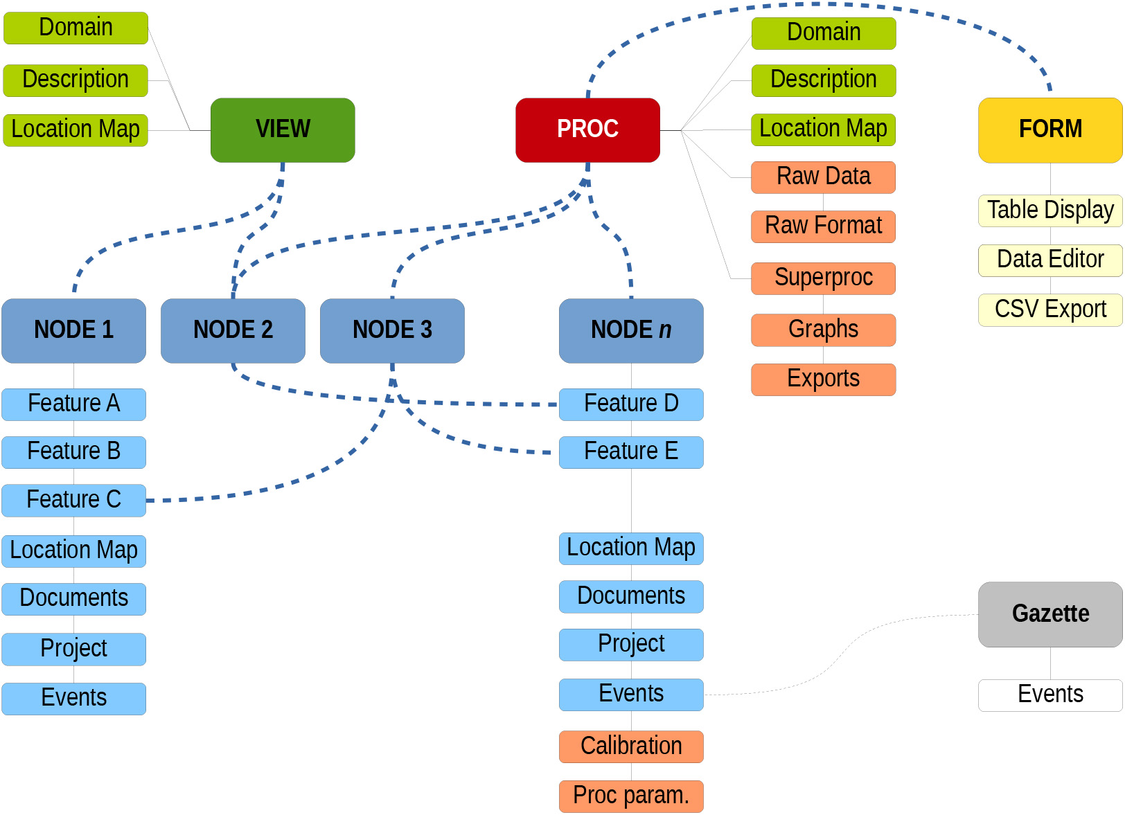
Overview of WebObs structure and objects: dashed line stands for editable association between two objects, solid line stands for preset attribute to an object (see text for explanation).
2.3.3. Principles of Procs
A proc drives the processing of any available data from its associated nodes using one of the available superproc as its processing core. The proc's configuration file defines parameters that apply to all nodes, including a default data format, preset moving time windows, filtering options or specific processing variables. Each node has its own configuration file, possible specific data format and channels description (names, unit, offset, gain, min/max values, location, …). Once imported, data from nodes have the same variable structure: a vector of timestamps and a matrix of corresponding data values. Some types of data may have a matrix of errors and a matrix of text-content additional data. The proc uses data samples as dated numerical values and the current time as a reference. Because of the required real-time context, all the signal processing must be causal, i.e., outputs will depend only on past and present inputs. Time zones are taken into account individually for each node, and one for the proc outputs.
A proc is constructed to produce, for each time window, one graph per node and a series of “summary” graphs that combine all the nodes and/or make elaborated calculation that uses all nodes together, e.g., for an integrated model. Each graph is written in vectorial format (EPS or PDF), converted to raster image (PNG) for fast display and a thumbnail (JPG), and is associated with an exportable data file in simple text format. Automatic tasks overwrite the outputs to keep them up-to-date with constant names, and display them on standard web pages with automatic refresh (see an example at Figure S5). An other output of procs is the status of a node: the last valid data timestamp is compared to a time delay to set if the node is active or not, while the amount of valid data on a certain period is compared to the theoretical acquisition period to compute a sampling rate performance. These indicators are displayed in the main proc's table to give an overview of a network health status. Some specific procs may produce per-event outputs, e.g., for earthquake events, in that case all former outputs will be stored and accessible by date.
Any user may submit a proc request after filling a web-form of dates interval, graphical options and some selected proc's parameters. This request will run exactly the same proc code and data as used for periodic task, but the outputs (graphical and data exports) will be written in a separated folder and an email will notify the user of the end of the job. This functionality is also useful to test proc's parameters and adjust the configuration of periodic tasks.
2.3.4. System Administration, Install and Upgrade
WO is distributed with a single binary package, a detailed README file, and a user manual. A bash script creates the disk structure, detects missing dependencies and installs the system with default jobs, examples of views and procs. The same setup script is used to upgrade code, documentation and configuration to a new version. The results presented in this paper correspond to version v2.1.4, dated November 2019.
System administration can be achieved using shell commands after logging in on the server, while some important tools can be handled through the web interface: grids and nodes management, tasks scheduler (see Figure S8), user administration, configuration files editor, wiki pages. Each proc can activate a debug mode to increase log verbosity.
WO is delivered with English and French interface, but the system is open to other languages as the code uses an internationalization system.
Finally, the code development, projects and issues tracking is achieved through a GIT repository (see Data Availability section).
3. Results
In the French observatories, WO has become a key tool for data monitoring but also for most of the everyday use as it centralizes any information on technical equipments, team management and other observatory activities. Over the years, scientists have used the WO environment to develop their own procs dedicated to each monitoring method. Here we describe how observatories are using the WO system and what are the main outputs in the light of observatory goals. An overview of WO screenshots is also available in the Supplementary Materials.
3.1. Observatory Equipment and Team Management
The combination of nodes and grids is mainly used for instrumental stations and sites of measurement on the volcano or for regional tectonic surveys. For a station, the node regroups all the technical information on the equipment, including the log of maintenance, exploiting node's features to describe, for example, sensor(s), digitizer, power supply, transmission, firmware version, network addresses, monument dimensions, serial numbers, connector types, length of cables, etc. For instrumental stations, the calibration table stores the gain or offset changes in time for each channel or sensor component, using simple linear formula: where d is the raw data, G the instrumental gain, F a calibration factor in physical unit per count or raw data unit), O an offset, and D the calibrated data in physical unit. There is also the possibility to filter raw values using minimum and/or maximum thresholds in order to exclude outliers.
A station can be also a simple radio repeater, a satellite hub, without any sensor. Since any node's feature can be linked to another node's feature, it is possible for example to link two stations that use the same power or same transmission system. A text description of how to access the station, eventually with contact numbers or site opening hours, completes the list. The aim of a node page for stations is to include all the necessary information for a technician who must act on the equipment (see an example of instrumental node full page in Figure S3).
For a measurement or sampling site like an EDM reflector, a hot spring or a fumarole, the node also describes the access and environment of each site. Accessing the WO page from the field, or bring a hard copy is one of the good practices to improve the field work efficiency. Of course, the staff must fill out the forms after each maintenance task.
The nodes are also used for non-instrumental equipments like data archive collections, buildings, electricity (power generator, inverter, …), pool of computers, vehicles, health and safety procedures (hurricane season, safety equipment, …). Other important uses of non-instrumental nodes are journals of phenomenological observations, like historical volcanic unrests, major earthquakes, tsunamis or volcano-related visual observations or meteorological events, especially to collect testimonies. This is a fundamental feature because it allows to constitute an electronic log-book of all events occurring and actions taken during a crisis event with the ability to have keywords in the observation made and a time stamp. A search for keywords can then later be done. In these cases, the node's features are adapted to describe each “object” and the dated events and associated photos and documents are the main utilities.
When a node has geographical coordinates, an automatic location map will be associated with it (see Figure 3). A global interactive map of all the grid's nodes is also updated.
Figure 3
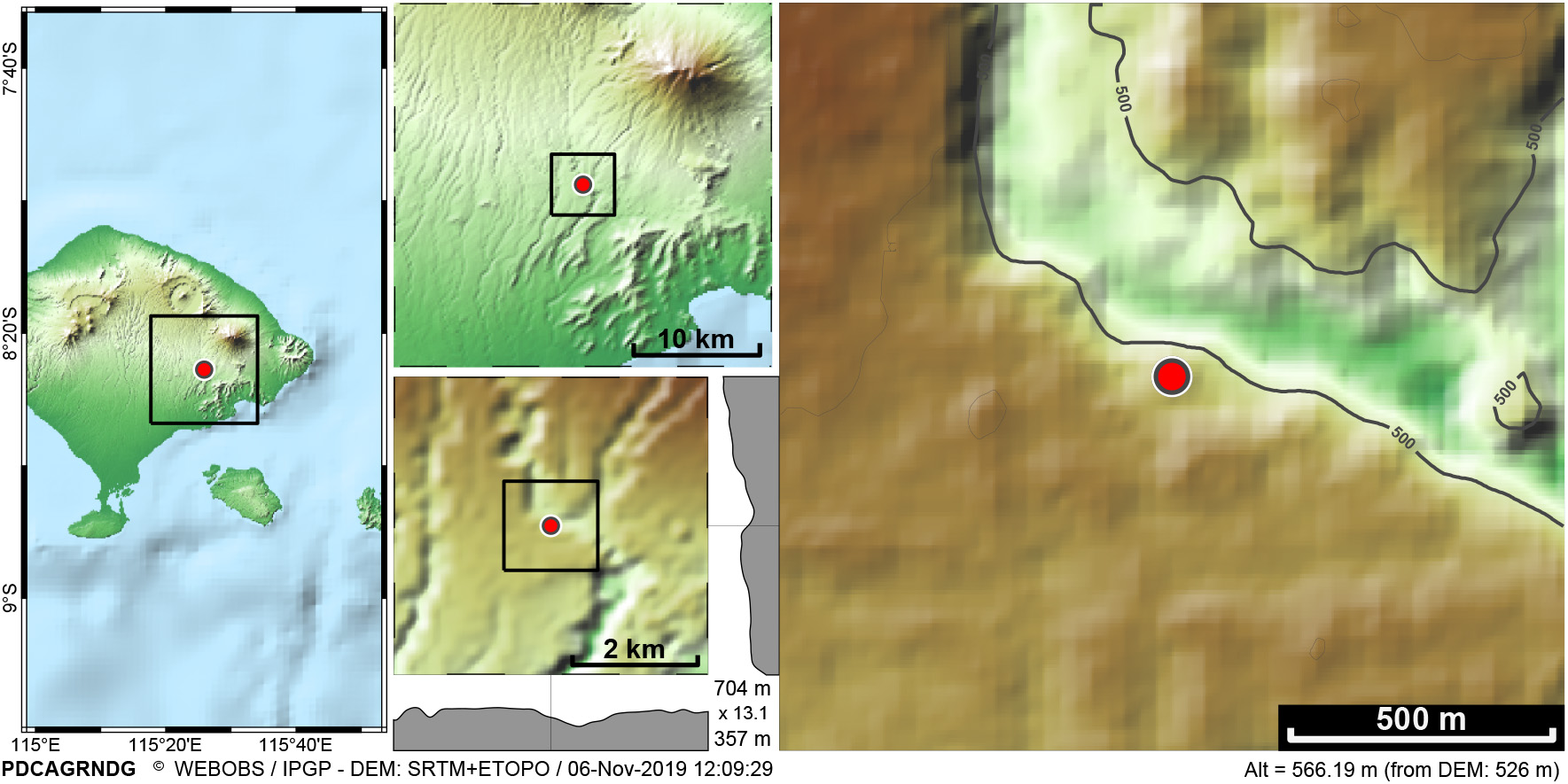
Example of a node location map: Four levels of zooms around the station (red circle) using automatic downloading and merging of SRTM1 and ETOPO1 data for global topography and bathymetry. Cross sections to look at possible topography incidence and estimation of altitude value interpolated from the DEM itself. The right frame might use a user-defined DEM if available.
Additional web pages offering static content have been created for more specific uses, when a list of nodes is not necessary, e.g.,:
team members contact address and number,
assistance, maintenance and local suppliers contacts,
crisis management instructions,
publication list.
3.2. Periodic Data Processing
Besides the management of sites, sensors, equipment, and measurements, the second pillar of WO is the capacity to make periodic data processing with dedicated automatic scripts for some standard techniques of monitoring.
3.2.1. Seismic Chart and Bulletin
For the seismic continuous and high frequency data flux, WO proposes an innovative combination of a digital stripchart paper for multiple data streams, a manual and semi-automatic detection and classification of events, and a bulletin with dynamic graphs of event types: hourly/daily/moving histogram, cumulated number of events, cumulated seismic moment and Gutenberg-Richter diagram. The system accepts SEED and Earthworm data protocols, some basic filtering (median/trend removal, low/high/band pass or bandstop Butterworth/Bessel/Chebyshev N-order filters) and the catalog can be linked to external earthquake databases (local QuakeML or any web-service FDSN compatible) and a raw data access in miniSEED format.
The objective of these tools is to construct and update a human-controlled earthquake bulletin, offering the possibility to visually detect and/or check automatic triggered events, and classifying the type from a customized list. The system offers a synthetic view of up to 15 simultaneous channels at different time scales, an efficient way to immediately detect and recognize the origin of events (see Figure 4 and Figure S7). The seismic bulletin named “main courante” (handtrail) can be linked to multiple stripcharts ‘sefran’ (named after a former French seismograph system), allowing for example one stripchart with volcano stations and one for the regional tectonic activity. The sefran includes a broom-wagon process that fills up the gaps due to real-time data packet loss.
Figure 4
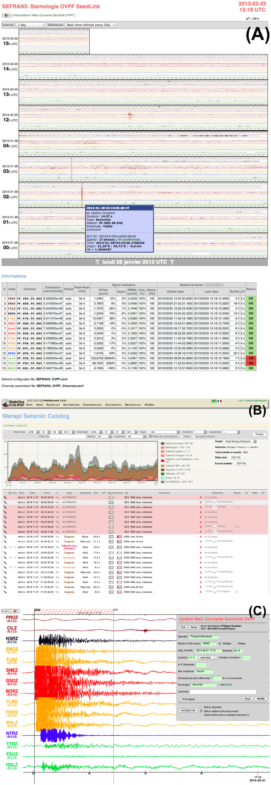
Seismic stripchart and bulletin: (A) real-time last hours of the multichannel seismogram as hourly thumbnails, indication of events, statistics on channels. (B) Seismic bulletin table of classified events and graphs, red background stand for automatic unclassified events. (C) Form to edit and submit an event with high-speed scale seismograms, channels are North-South sorted, colors have been set to areas related to the volcano (data from BPPTKG/CVGHM and OVPF/IPGP).
At Piton de la Fournaise volcano, La Soufrière of Guadeloupe volcano, and Mayotte volcano, we have also implemented an automatic classification method based on the machine learning approach, and tested the possible integration into WO as an automatic suggestion of event types during the human validation (Maggi et al., 2017).
3.2.2. Seismic Swarms
This superproc uses seismic catalogs and bulletins to compute and plot the seismic rate, the cumulated moment, and to detect seismic swarms using thresholds over moving intervals (see an example in Figure S6).
3.2.3. Generic Time Series
This superproc will produce time series graphs of any node channels, with some filtering possibilities (moving median, moving average, picks cleanup, decimation), plotted as one graph per node and one summary graph with selected common channels. Combined with input data formats capabilities, these procs allow the basic generic plot of any non-specific real-time data (see Figure 5).
Figure 5
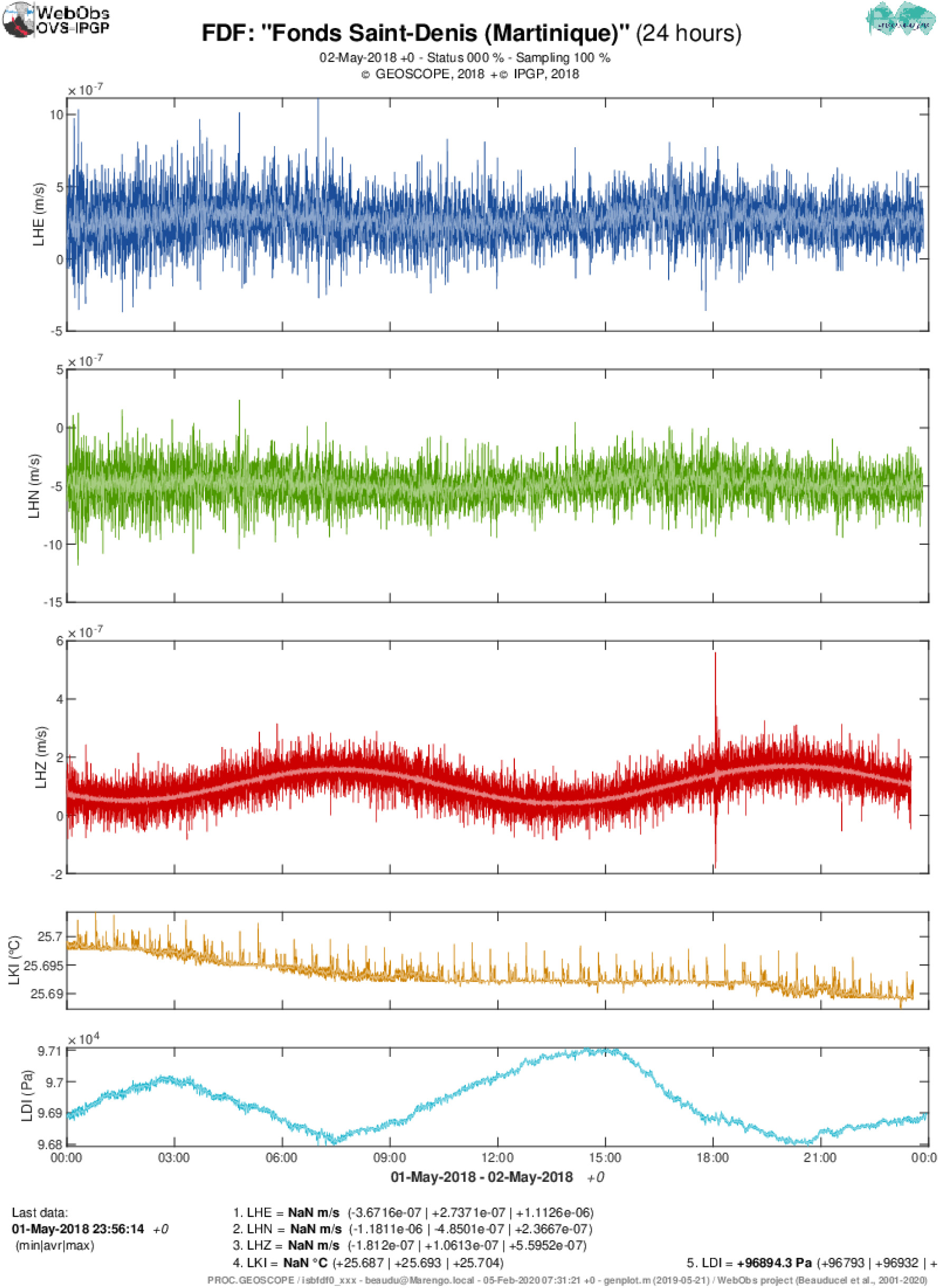
Example of a generic time series proc: channels from a very broadband seismic station (STS-2 3-component, atmospheric temperature and pressure) using SeisComP3 Arclink data request. Station codes, data format and data source are defined in the node configuration, channels description and codes are set in the calibration file. Each subplot has 10-sample moving average as lighter color lines. Channel subplot order and relative height is configurable in the proc parameters (data from GEOSCOPE).
3.2.4. Seismic Helicorders
WO proposes its own drum helicorder graphs, from single component and customizable time sheet length, rotating speed and colors (see Figure 6).
Figure 6
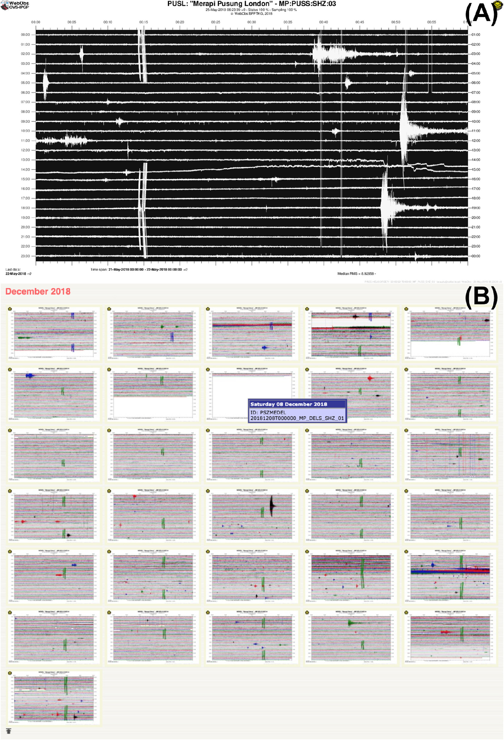
Example of seismic helicorder with an analog short-period station: (A) smoked-paper colors and pen-rotating effect, (B) screen-shot of daily thumbnails page over one full month of recording (data from BPPTKG/CVGHM).
3.2.5. Hypocenter Maps
Hypocenter maps operate earthquake catalogs at customizable geographic scales with vertical cross-sections, magnitude and quality filters, depth or time color scale (see Figure 7), and possible time series of earthquake location, depth and magnitude. For this superproc, the associated nodes are the catalogs, so it is possible to merge different formats, e.g., some Hypo71 files for historical catalog and a FDSN web-service request for recent data.
Figure 7
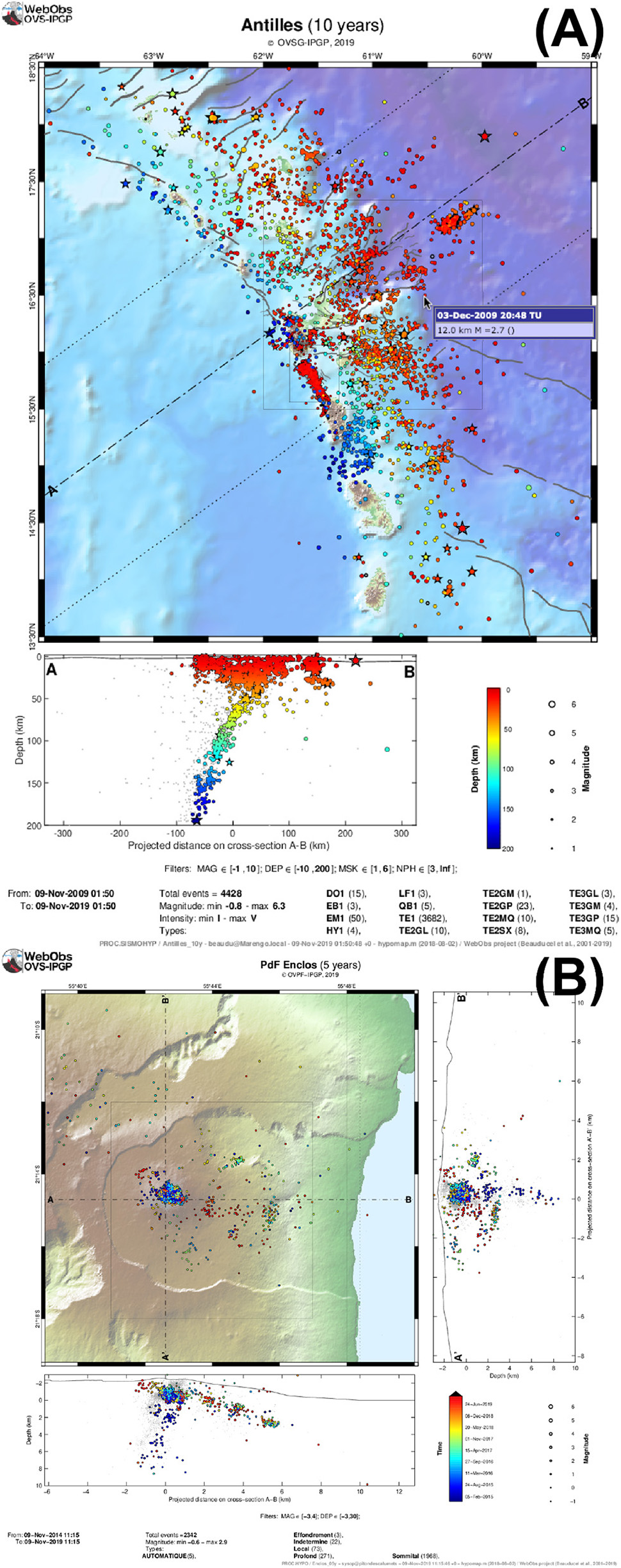
Example of seismic hypocenter maps: (A) regional map with oblique cross-section, and mouse pointer showing an event details, (B) zoomed map on a volcano with time colormap and two vertical cross-sections (data from OVSG/IPGP and OVPF/IPGP).
3.2.6. Felt Earthquake Reports
This superproc produces automatic reports for earthquakes that are potentially felt. Based on a catalog of events defined by the associated nodes, it uses location and magnitude to compute theoretical ground acceleration and macroseismic intensities through a combination of ground motion prediction equation and ground motion intensity conversion equation. The report includes a map of average and maximum peak ground accelerations and intensities, considering potential site effects, for selected local towns (see Figure 8). The text content and language is fully customizable (templates are in English and French). This report is produced automatically at each new event or reassessment of the epicenter, depth or magnitude, so it is possible to send it to medias and authorities within few minutes after the event (Beauducel et al., 2011).
Figure 8
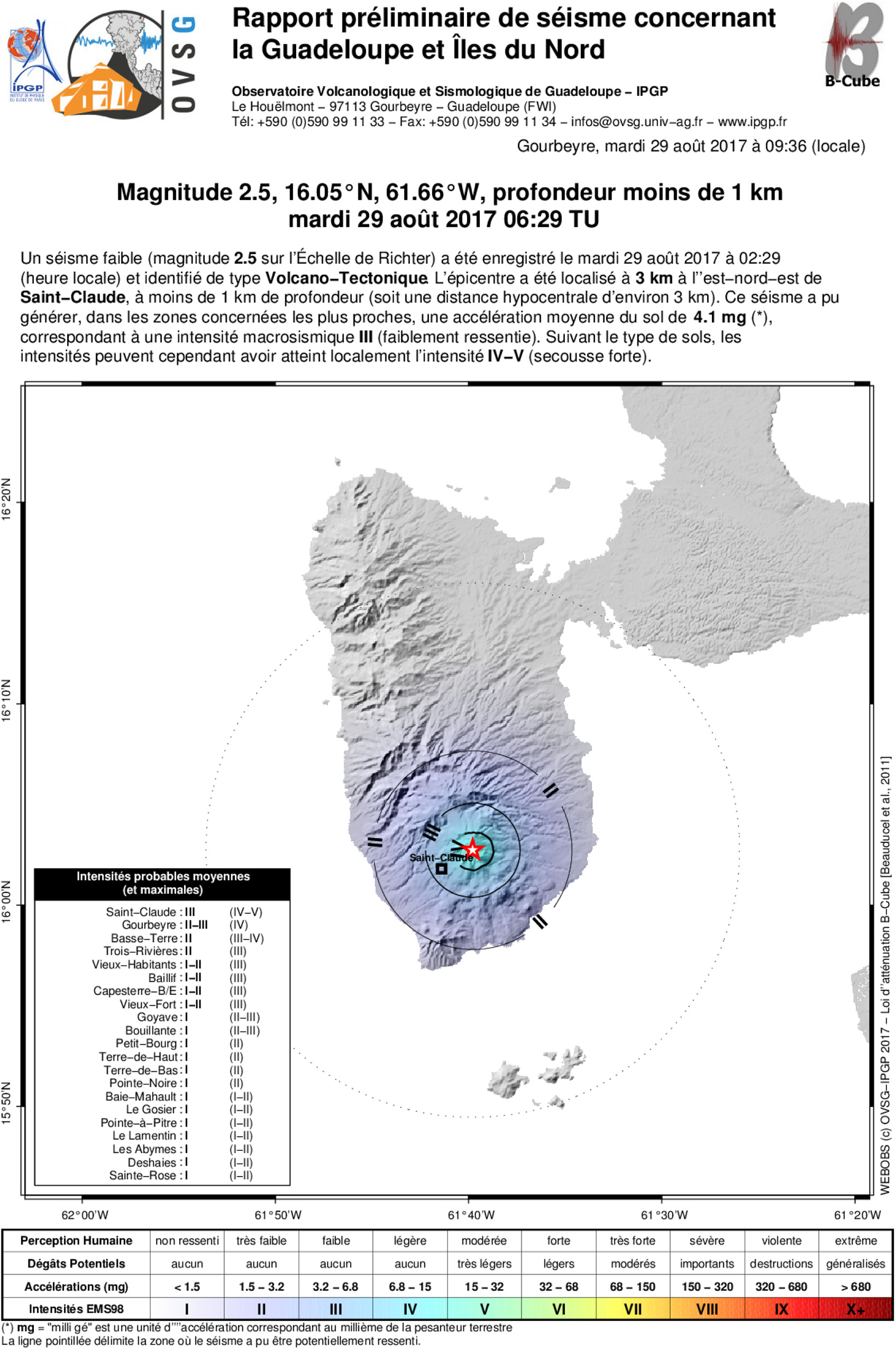
Example of automatic report for a potentially felt earthquake: Epicenter, mean macroseismic intensities and exhaustive list of towns or neighborhood islands where the event could be felt, with maximum intensity in case of site amplification (data from OVSG/IPGP).
The seismic bulletin media contains a link to the existing reports when applicable.
3.2.7. RSAM
Real-time Seismic Amplitude Measurement (RSAM) is a useful tool to follow the time evolution of a seismic crisis (Endo and Murray, 1991). At the moment WO does not compute the RSAM values since standard acquisition systems are able to produce RSAM data streams efficiently. The superproc imports RSAM channels from standard data streams to make time-series plots (linear and log scales) for each station. A dedicated graph computes time-dependent maps of the seismic source from spatial RSAM amplitudes, a simple and efficient method to locate the origin of an eruptive tremor (Figure 9).
Figure 9
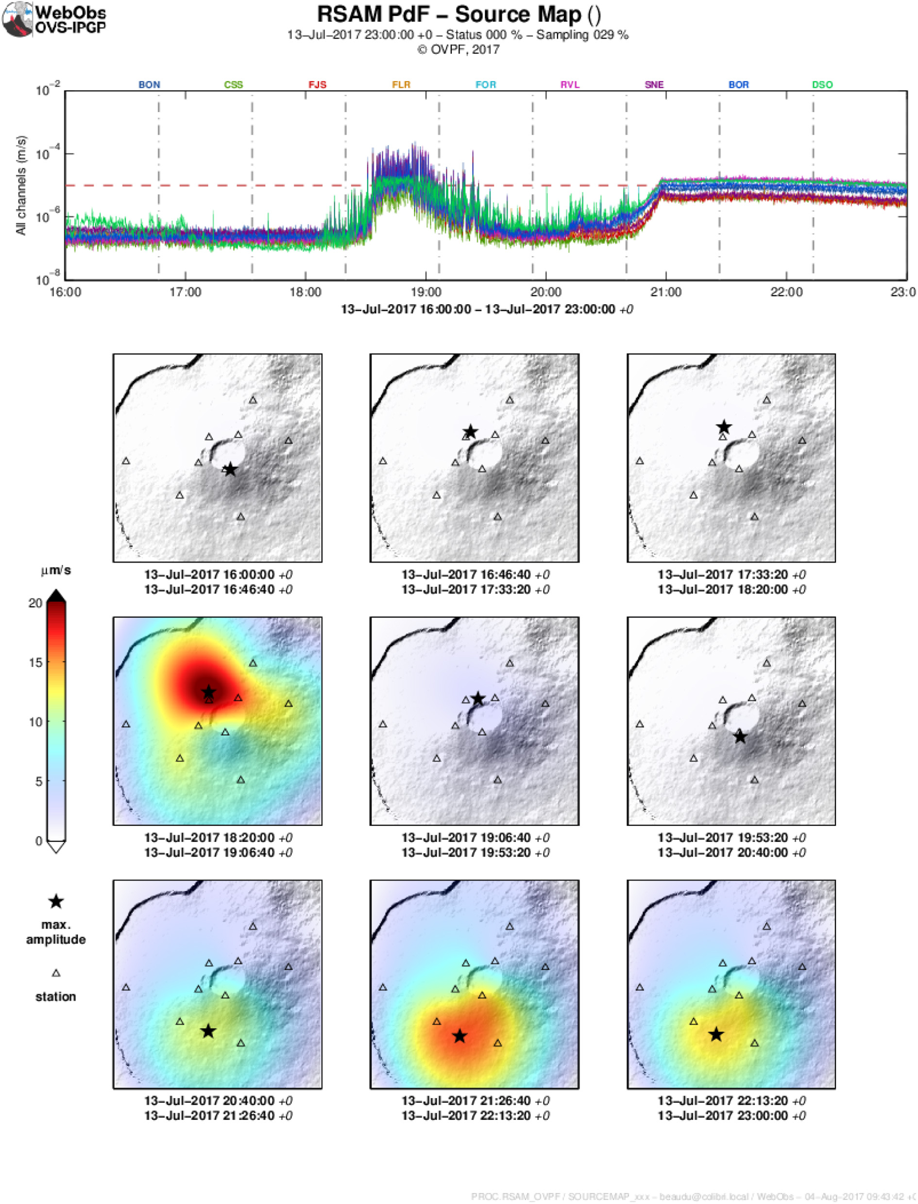
Example of seismic amplitude measurement (RSAM) plots: time series in log scale and arbitrary threshold level, timeline source mapping to locate the eruptive tremor source (data from OVPF/IPGP).
3.2.8. Tilt
Tiltmeter data can be processed using a dedicated superproc that plots time series of the two components and a soil temperature, per node and integrated in a summary graph, a map of vector trends, and a source modeling using an isotropic point of inflation/deflation through exhaustive grid search to determine the spatial probability of a source and volume variation (Beauducel and Carbone, 2015). It is possible to add an a priori target location to plot tilt amplitudes vs. distances from the target.
3.2.9. GNSS
For GNSS solution data, WO proposes enhanced processing and graphs that includes (Beauducel et al., 2014): tectonic trend correction, absolute or relative velocity referencing (using one or more stations as reference), per node and summary time series plots of the three components (East, North, Up), principal component analysis, customizable baselines between pairs of stations, velocity vector map, particle motion map, source modeling using an isotropic point of inflation/deflation through exhaustive grid search to determine the spatial probability of a source and volume variation, and finally, time series of the best model parameters using different periods of integration for trend estimation (see Figure 10). Among the large number of parameters, it is possible to model only the horizontal components, to add an a priori target location to plot displacement amplitudes vs. distances from the target, and to constrain the source location using a gaussian-shape distance probability function.
Figure 10
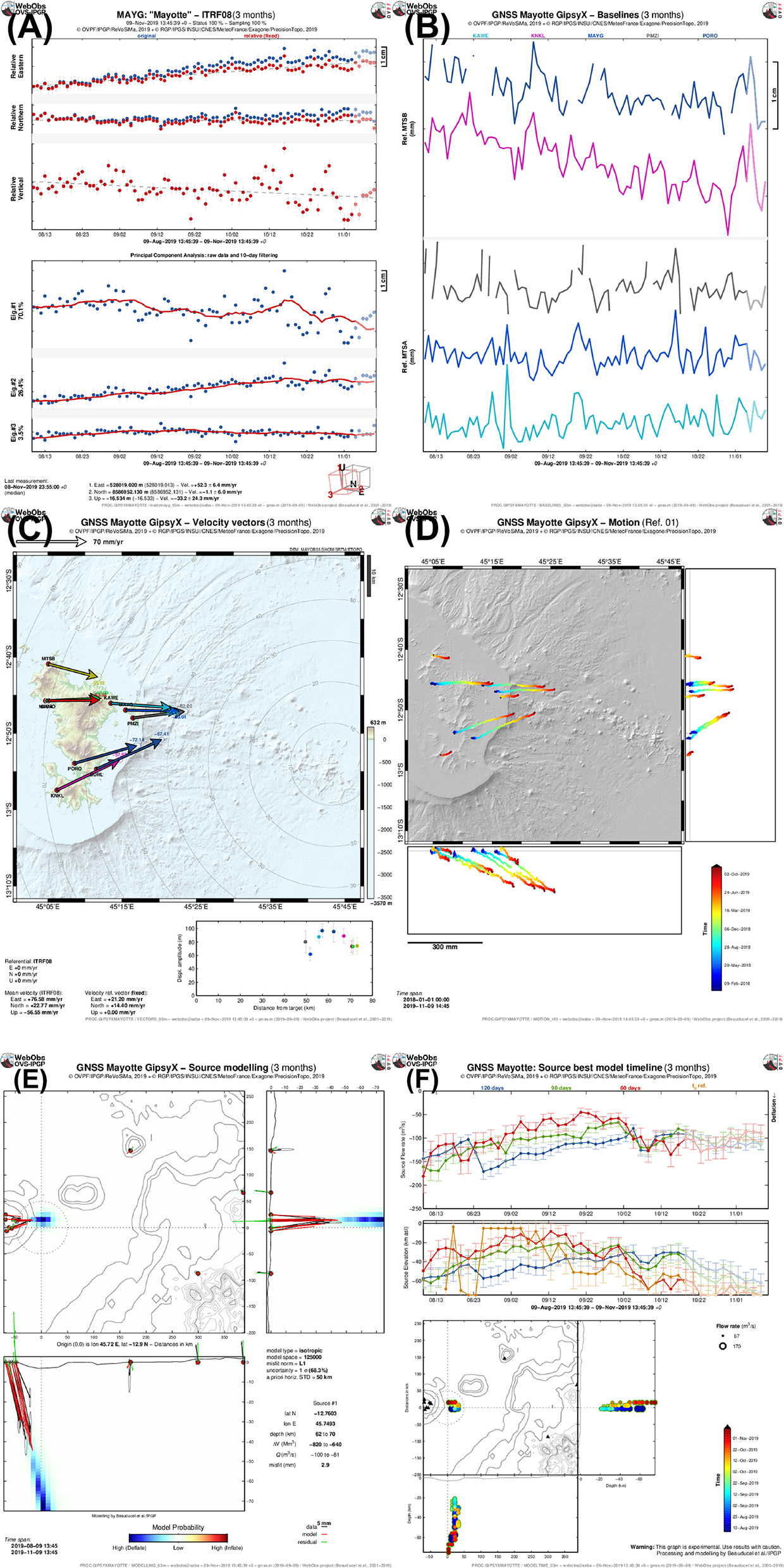
Example of graphs produced by a GNSS proc: (A) single node time series of original and relative components, and principal component analysis; (B) baselines node pairs time series; (C) velocity trend vectors map with amplitude vs. distance from target plot; (D) displacement motion map. Background map is made from user-defined bathymetry DEM (Feuillet, 2019) (data from ReVoSiMa). (E) Source modeling map using an isotropic point and grid search exploration; (F) best models time series showing source flux, depth, and location.
This superproc is able to read several GNSS solution formats like Gipsy-Oasis/GipsyX (Desai et al., 2014), Gamit/Globk (Herring et al., 2010), and USGS “rneu” GPS files. When the orbit type is available, it is indicated on the graphs as shaded colors (e.g., final, rapid and ultra orbits from Gipsy/JPL software). Node's calibration file can be used to apply offset corrections due to antenna or benchmark changes or to correct local earthquake co-seismic displacements.
3.2.10. Extensometry
Extensometers are useful to monitor active cracks and fractures. The superproc makes time series of linear distance, air temperature and wind strength for each station, a summary graph of all distances grouped in geographic zones and a map showing extensive or compressive oriented arrows of displacements (Tamburello et al., 2019). A specific form is available to manage manual data input in a dedicated database (see section 3.3.3).
3.2.11. Volcanic Gas
This superproc plots simple time series of physical and chemical parameters from fumarole sampling on-site measurements and laboratory analysis: temperature, pH, velocity, major elements, isotopes and sulfur/carbon ratio. A specific form is available to manage manual data input in a dedicated database (see section 3.3.1).
3.2.12. Hot Springs
This superproc operates physical and chemical parameters from hot springs water sampling on-site measurements and laboratory analysis: air and water temperature, sampling condition, pH, conductivity, cation and anion concentrations, some isotopes. The superproc is able to plot time series of single element or element ratio time (like chlorine/sulfur or carbon/sulfur) and ternary plots (magnesium/calcium/sodium and chlorine/sulfate/carbonate). A specific form is available to manage manual data input in a dedicated database (see Figure 12 and section 3.3.2).
3.2.13. Weather Station
This superproc is able to handle data from multi-sensor weather station: raingauge, temperature, pressure, humidity, wind speed and direction, irradiation, battery voltage. The plot content can be adapted to the available data. There is a special tool to send an alert based on a rain threshold (in mm/day) and to send an end-of-alert after a delay, using the notification facility of WO (see Figure 11).
Figure 11
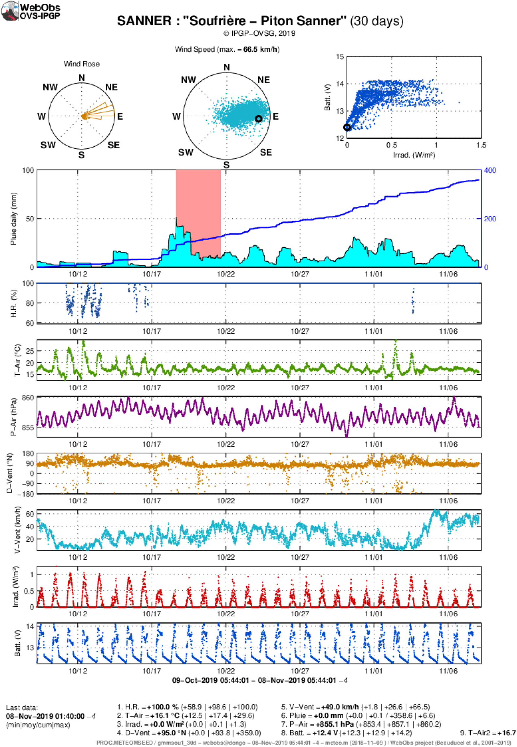
Example of meteorological station graph: wind rose azimuthal histogram, wind direction and speed polar plot, battery voltage vs. solar irradiation, rain gauge using moving sum daily curve, cumulated and alert threshold, other parameters as simple time series (data from OVSG/IPGP).
3.3. Manual Data Forms
The objective of the forms is to handle manual data from human input, edit and validate values associated with a node, i.e., a sampling or measurement site. Each form is adapted to the type of data and scientist needs, but has in common the date and time and the associated node. In particular, input values are checked using specific tests to alert the operator on possible typing error. A table presents the data with date interval, individual node or proc selection, filter on the comments using regular expression, optional ratios, also display the check flag with background colors. Selected data can be exported in simple coma separated value text files.
A web form fits particularly well the observatory needs since it offers the possibility to enter on-site measurement values from or after the field work, then complete the entry when receiving the laboratory analysis, days or weeks after. All authorized operators can view or edit the sample data, while the associated proc produces updated graphs for final check and interpretation.
3.3.1. Volcanic Gas Analysis
This form is dedicated to fumarole physical and chemical parameters from on-site measurements and laboratory analysis. Each data sample has the following channel: temperature, pH, velocity, type of vial sampling (P2O5, NaOH, void), major elements (H2, H2S, He, Ar, CO, CO2, CH4, SO2, N2, O2), isotopes (δ13C, δ18O, 222Rn). The form computes the ratio total sulfur over carbon content.
3.3.2. Water Chemical Analysis
This form is dedicated to water physical and chemical parameters from on-site measurements and laboratory analysis. Each data sample has the following channel: air and water temperature, sampling condition (e.g., primary or secondary griffon, water piping, reservoir, condensate), pH, conductivity, flow rate, water level, cation content (Li+, Na+, K++, Mg++, Ca++), anion (F−, Cl−, Br−, , , , I−), silicate (SiO2), and isotopes (δ13C, δ18O, δD). The typing check consists in calculating total H+ ions and the NICB (see Figures 12A,B).
Figure 12
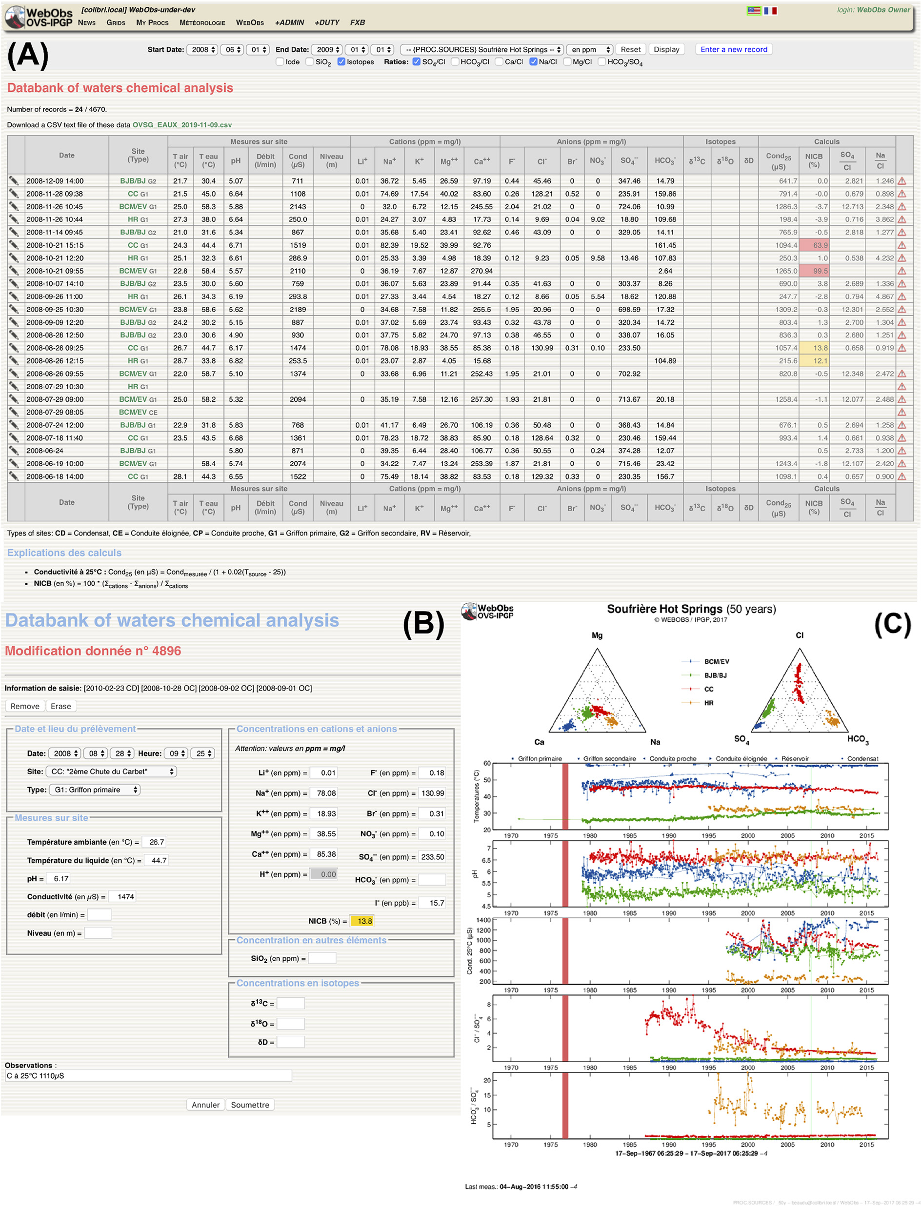
Hot springs data form and associated proc for water chemical analysis: (A) table of data samples with search tools, component ratio calculation and colored check flags, (B) example of a data form edition (data from OVSG/IPGP); (C) summary graph over a 50-year period (data from OVSG/IPGP).
3.3.3. Extensometer, Fissurometer, and Electronic Distance Measurement
These forms are dedicated to a specific type of manual measurement on-site, in order to compute an average value and associated uncertainty from repeated measurements by operators on one or three components of displacements. The database stores every measurement and computes the mean and standard deviation value. Checking consists in alerting on abnormal standard deviation values.
4. Discussion
The first years of development, starting in late 2000, have been spent constructing a dedicated solution for the Volcanological and Seismological Observatory of Guadeloupe, which has around 25 different monitoring networks for La Soufrière volcano and the Lesser Antilles regional seismicity and geodesy monitoring network. Early development had been using modest means that might explain some of our initial technical choices. This first relatively stable alpha version has been used efficiently for years and has been specifically adapted to some other observatories (Truong et al., 2009; Cole et al., 2010). A second age of the project started in 2012 and allowed us to expand the concept to other observatories in a more open way, focusing the development on coding barriers breakdown in order to built a real open-source participative software project, as described in this paper.
We can summarize the benefits of the WO system usage that we experienced during the last 19 years in three main points.
4.1. Everyday, Long-Term Monitoring
For daily use, WO has become a hub and unique tool in the French volcanological and seismological observatories (IPGP) for network, equipment, analysis, interpretation and some administrative management. It is the backbone of scientific crisis response during the numerous unrest and eruptive phases that have been experienced by all of the French observatories over the past two decades. It centralizes phenomenological observations as journals and technical maintenance as logs and data catalogs. Manual forms are edited simultaneously from overseas and mainland France analytical laboratories. Periodic graphs are displayed on large screens in the monitoring room and serve as discussion support for weekly meetings, including with distant participants via videoconferencing. Manual requests are extensively used to produce figures for monthly or annual reports as well as for technical and crisis response meetings with authorities, and for public outreach and community awareness. Data export is used by researchers to make their own processing and journal figures.
4.2. Crisis Management
The first application of WO as a support for crisis management was not for a volcanic unrest but a local crustal earthquake, a magnitude 6.3 shallow event that occurred in the Lesser Antilles in 2004 (Bazin et al., 2010). WO helped the Volcanological and Seismological Observatory of Guadeloupe in following the aftershocks sequence that lasted for years after the main shock, and in the daily communication with authorities and population after each of the felt event. It has been also easy to develop new dedicated graphs for Omori's law and Gutenberg-Richter statistics and integrate them in the system.
At Piton de la Fournaise (La Réunion), we experienced a typical situation where the observatory had developed already its own dedicated applications for each monitoring techniques, but faced some long-term software maintenance issues. Thus, WO has been installed later and progressively, as a replacement of the obsolete tools, has contributed to improve them with new functionalities and taking advantage of the collaborative open-source project. WO is presently used during each of the eruptions for detecting precursors and following the eruption progress, mainly with seismic and deformations data. In addition, the WO platform is perfectly adapted to allow remote duty scientists from mainland France to assist in real-time to the crisis response on La Réunion thus giving scientists locally time to rest and take some distance from the ongoing unrest and or crisis. This applies also to any unrest and potential eruptive activity at La Soufrière of Guadeloupe (Moretti et al., 2020) or La Montagne Pelée in Martinique.
At Mt. Agung (Bali), WO was installed and used for GNSS data processing during the 2017 crisis paradigm, in order to estimate the magma source volumes at depth from deformation modeling. We were able to adapt data format and some processing strategy due to network specificity and deliver the results to Indonesian authorities within only a few days. Modeling results have contributed to alert level decrease and exclusion zone reduction decision-making (Syahbana et al., 2019).
In 2018, WO was installed very rapidly and used extensively to follow the seismic activity and abnormal deformation due the submarine eruption of a new volcano offshore Mayotte island (REVOSIMA, 2019). Given that a national consortium (REVOSIMA) of many French institutions and universities managed this major crisis, WO gave the possibility to set up a daily monitoring of the activity. Indeed, on-duty scientists performed a check-up of the various parameters using self-generated product graphics of WO. Thus, a wide range of specialists in various fields and from different national institutions participated in the day-today monitoring. Moreover, WO facilitated the share of tasks, like the analysis and localization of seismic signals among different institutes and universities, as it is able to collect data and products from different databases and merge them into one single database (e.g., SeisComP3 catalog of earthquake events). WO has been pivotal in the complex daily and structured, collegial efficient scientific response to the ongoing Mayotte crisis, especially to create synergies among the scientific response team and to report to authorities in charge of civil protection decisions.
4.3. Research Development Environment
Through the concept of procs and superprocs, the WO environment allows scientists to focus on the testing of ideas and innovative processing on the real-time data, as the import of the source data and the access and export of the results are handled by the system. To develop a new superproc, scientists can use a library of generic functions that read any parameters from the associated proc and import the node's data as numerical vector and matrix, then export graphs in the WO structure. Scientists thus do not have to care about the inputs and outputs and can focus on the processing itself, to create dedicated and complex figures.
In the recent cases of Mt. Agung eruption, the La Soufrière of Guadeloupe unrest, and the ongoing Mayotte eruption, we demonstrated that it was relatively easy to adapt existing superprocs and develop innovative functionalities to answer new requirements. The corresponding developments, made in runtime, have been committed to the open-source repository and became immediately available to other observatories.
Statements
Data availability statement
The open-source codes, documentation, developers forum and free access to installation packages can be found at the IPGP/WebObs repository: https://github.com/IPGP/webobs. Global elevation models are a merge of SRTM Non-Void Filled: https://doi.org/10.5066/F7K072R7 and ETOPO1: http://doi.org/10.7289/V5C8276M. Sample data are available at Volobsis IPGP data portal: http://volobsis.ipgp.fr, IGN RGP: http://rgp.ign.fr, and Geoscope: http://geoscope.ipgp.fr.
Author contributions
FB was the designer, primary developer, and project manager of the WebObs software. DL has collaborated to the full re-assessment of the code and has built library modules, technical documentation, administration tools, and a setup package. XB, J-MS, and PB were the present main coding contributors with FB. AB and DM have written the Perl codes of the early versions. CB, AL, CA-H, and AN have mainly contributed to the requirements specifications. AF has conducted the first beta-version installation tests at the Merapi volcano observatory.
Funding
The WebObs project has been supported mainly by IPGP and CNRS/INSU (SNOV, Observation National Service for Volcanology) funding for the French volcanological and seismological observatories. Additional fundings came from the French Ministry of Ecology (now MTES), the Spirales project from DSI-IRD, the French ANR Domerapi (ANR-12-BS06-0012), the IRD emergency budget, and finally EUROVOLC project that received funding from the European Union's Horizon 2020 research and innovation programme under grant agreement no. 731070. The French volcanological and seismological observatories have benefited from recurrent funding for network and infrastructural development from the local elected assemblies (Conseil Général de Guadeloupe, Conseil Régional de Guadeloupe, Collectivité Territoriale de Martinique, Conseil Départemental de La Réunion, Conseil Régional de La Réunion), the Préfecture de La Réunion, Préfecture de la Guadeloupe, Préfecture de la Martinique, the French Ministry of Overseas Territories, and from several projects from the European community (FEDER, CPER).
Acknowledgments
FB warmly thank many colleagues that have extensively used, supported or simply encouraged this project from the early thoughts in 2000 until the implementation at more than 15 observatories today: Jean-Louis Cheminée, Claude Jaupart, Stéphane Acounis, Gilbert Hammouya, Jean-Christophe Komorowski (also for having improved the English of the manuscript), Yves Caristan, Alberto Tarchini, Thierry Kitou, Xavier Lalanne, François Truong, Albert Tarantola, Pierre Briole, Jacques Varet, Frédéric Randriamora, Benoît Coste, Roderick Stewart, Valérie Clouard, Nathalie Feuillet, Cyril Aubaud, Philippe Kowalski, Florent Brenguier, Valérie Ferrazzini, Stephen Roselia, Laura Henriette, Frédérick Massin, Marie-Paule Bouin, Jean-Bernard de Chabalier, I. Gusti Made Agung Nandaka, Éric Lajeunesse, Céline Dessert, Andrea Di Muro, Nicolas Villeneuve, Frédéric Lauret, Jean-Philippe Métaxian (also for having reread the initial manuscript), Agus Budi Santoso, Sulistiyani, Hendra Gunawan, Devy Kamil Syahbana, Benoît Taisne, Chiou Ting Tan, Lauriane Chardot, Christina Widiwijayanti, Aline Peltier, Claudio Satriano, Anne-Marie Lejeune, Roberto Moretti, David Jessop, Sébastien Deroussi, Guillaume Ucciani, Arnaud Burtin, Tristan Didier, Edgar Lenhof, Adolfo Inza, and Anne Le Friant. Special thanks to Steve Tait and Pierre Agrinier for having secured a decisive fund for DL's contract, and to all the daily users for any constructive and beneficial criticism. Many thanks to two enthusiastic reviewers, and to the editor, Fidel Costa. IPGP contribution 4111.
Conflict of interest
The authors declare that the research was conducted in the absence of any commercial or financial relationships that could be construed as a potential conflict of interest.
Supplementary material
The Supplementary Material for this article can be found online at: https://www.frontiersin.org/articles/10.3389/feart.2020.00048/full#supplementary-material
References
1
Battaglia M. Cervelli P. F. Murray J. R. (2013). dMODELS: a MATLAB software package for modeling crustal deformation near active faults and volcanic centers. J. Volcanol. Geother. Res.254, 1–4. 10.1016/j.jvolgeores.2012.12.018
2
Bazin S. Feuillet N. Duclos C. Crawford W. Nercessian A. Bengoubou-Valérius M. et al . (2010). The 2004-2005 les saintes (french west indies) seismic aftershock sequence observed with ocean bottom seismometers. Tectonophysics489, 91–103. 10.1016/j.tecto.2010.04.005
3
Beauducel F. (1998). Structures et comportement mécanique du volcan Merapi (Java): une approche méthodologique du champ de déformations. (Ph.D. thesis). Université Paris 7, Institut de Physique du Globe de Paris.
4
Beauducel F. (2006). Surveillance opérationnelle des volcans français: développements récents à la Guadeloupe. Géosciences BRGM4, 64–68.
5
Beauducel F. Anténor-Habazac C. (2002). Quelques éléments d'une surveillance opérationnelle…, in Journées des Observatoires Volcanologiques (Paris: Institut de Physique du Globe de Paris).
6
Beauducel F. Anténor-Habazac C. Mallarino D. (2004). WEBOVS: integrated monitoring system interface for volcano observatories, in IAVCEI General Assembly, Pucon, Chile, 14-16 November 2004 (IAVCEI).
7
Beauducel F. Bazin S. Bengoubou-Valérius M. Bouin M. Bosson A. Anténor-Habazac C. et al . (2011). Empirical model for rapid macroseismic intensities prediction in Guadeloupe and Martinique. C. R. Geosci.343, 717–728. 10.1016/j.crte.2011.09.004
8
Beauducel F. Bosson A. Randriamora F. Anténor-Habazac C. Lemarchand A. Saurel J.-M. et al . (2010). Recent advances in the Lesser Antilles observatories Part 2: WebObs - an integrated web-based system for monitoring and networks management, in European Geophysical Union General Assembly (Vienna).
9
Beauducel F. Carbone D. (2015). A strategy to explore the topography-driven distortions in the tilt field induced by a spherical pressure source: the case of Mt Etna. Geophys. J. Int.201, 1471–1481. 10.1093/gji/ggv076
10
Beauducel F. Nurnaning A. Iguchi M. Fahmi A. Nandaka M. Sumarti S. et al . (2014). Real-time source deformation modeling through GNSS permanent stations at Merapi volcano (Indonesia), in AGU Fall Meeting Abstracts (San Francisco, CA).
11
Cervelli D. Cervelli P. Miklius A. Krug R. Lisowski M. (2002). VALVE: volcano analysis and visualization environment, in AGU Fall Meeting Abstracts (San Francisco, CA).
12
Cervelli D. Cervelli P. Murray T. (2004). New software for long-term storage and analysis of seismic wave data, in AGU Fall Meeting Abstracts (San Francisco, CA).
13
Cervelli P. Miklius A. Antolik L. Parker T. Cervelli D. (2011). General purpose real-time11 data analysis and visualization software for Volcano observatories, in AGU Fall Meeting Abstracts.
14
Cole P. Bass V. Christopher T. Eligon C. Murrell C. Odbert H. et al . (2010). Report to the Scientific Advisory Committee on Volcanic Activity at Soufrière Hills Volcano, Montserrat: Report on Activity Between 28 February 2010 and 31 October 2010. Flemmings: Montserrat Volcano Observatory.
15
Cornelius R. R. Voight B. (1995). Graphical and PC-software analysis of volcano eruption precursors according to the Materials Failure Forecast Method (FFM). J. Volcanol. Geother. Res.64, 295–320. 10.1016/0377-0273(94)00078-U
16
Desai S. Bertiger W. Garcia-Fernandez M. Haines B. Murphy D. Selle C. et al . (2014). Status and plans at the JPL IGS analysis center, in International GNSS Service 2014 Workshop Compendium, Ed. IGS Central Bureau (Pasadena, CA: Jet Propulsion Laboratory California Institute of Technology), 53.
17
Endo E. T. Murray T. (1991). Real-time seismic amplitude measurement (RSAM): a volcano monitoring and prediction tool. Bull. Volcanol.53, 533–545. 10.1007/BF00298154
18
Feuillet N. (2019). MAYOBS1 Cruise, RV Marion Dufresne. 10.17600/18001217
19
Herring T. King R. McClusky S. (2010). Introduction to Gamit/Globk. Cambridge, MA: Massachusetts Institute of Technology.
20
Maggi A. Ferrazzini V. Hibert C. Beauducel F. Boissier P. Amemoutou A. (2017). Implementation of a multistation approach for automated event classification at Piton de la Fournaise volcano. Seismol. Res. Lett.88, 878–891. 10.1785/0220160189
21
Moretti R. Komorowski J.-C. Ucciani G. Moune S. Jessop D. de Chabalier J.-B. et al . (2020). The 2018 unrest phase at La Soufrière of Guadeloupe (French West Indies) andesitic volcano: scrutiny of a failed but prodromal phreatic eruption. J. Volcanol. Geotherm. Res.393:106769. 10.1016/j.jvolgeores.2020.106769
22
Murray T. L. (1990). A User's Guide to the PC-Based Time-Series Data-Management and Plotting Program BOB. Open-file Report 90-56, US Geological Survey.
23
Newhall C. Costa F. Ratdomopurbo A. Venezky D. Widiwijayanti C. Win N. T. Z. et al . (2017). WOVOdat–an online, growing library of worldwide volcanic unrest. J. Volcanol. Geother. Res.345, 184–199. 10.1016/j.jvolgeores.2017.08.003
24
REVOSIMA (2019). Bulletin de L'Activité Sismo-Volcanique à Mayotte. Technical Report ISSN: 2680-1205, IPGP/BRGM. Available online at: www.ipgp.fr/revosima
25
Syahbana D. Kasbani K. Suantika G. Prambada O. Andreas A. Saing U. et al . (2019). The 2017–19 activity at Mount Agung in Bali (Indonesia): intense unrest, monitoring, crisis response, evacuation, and eruption. Sci. Rep.9, 1–17. 10.1038/s41598-019-45295-9
26
Tamburello G. Moune S. Allard P. Venugopal S. Robert V. Rosas-Carbajal M. et al . (2019). Spatio-temporal relationships between fumarolic activity, hydrothermal fluid circulation and geophysical signals at an arc volcano in degassing unrest: La Soufrière of Guadeloupe (French West Indies). Geosciences9:480. 10.3390/geosciences9110480
27
Truong F. Lalanne X. Chulliat A. (2009). MAGIS: the information system of IPGP magnetic observatories, in Proceedings of the XIIIth IAGA Workshop on Geomagnetic Observatory Instruments, Data Acquisition and Processing, June 9-18 2008 (Golden, CO).
Summary
Keywords
volcanology, seismology, monitoring, real-time, modeling, database, metadata, web-services
Citation
Beauducel F, Lafon D, Béguin X, Saurel J-M, Bosson A, Mallarino D, Boissier P, Brunet C, Lemarchand A, Anténor-Habazac C, Nercessian A and Fahmi AA (2020) WebObs: The Volcano Observatories Missing Link Between Research and Real-Time Monitoring. Front. Earth Sci. 8:48. doi: 10.3389/feart.2020.00048
Received
30 November 2019
Accepted
12 February 2020
Published
27 February 2020
Volume
8 - 2020
Edited by
Fidel Costa, Nanyang Technological University, Singapore
Reviewed by
Sonia Calvari, National Institute of Geophysics and Volcanology, Italy; Silvio De Angelis, University of Liverpool, United Kingdom
Updates
Copyright
© 2020 Beauducel, Lafon, Béguin, Saurel, Bosson, Mallarino, Boissier, Brunet, Lemarchand, Anténor-Habazac, Nercessian and Fahmi.
This is an open-access article distributed under the terms of the Creative Commons Attribution License (CC BY). The use, distribution or reproduction in other forums is permitted, provided the original author(s) and the copyright owner(s) are credited and that the original publication in this journal is cited, in accordance with accepted academic practice. No use, distribution or reproduction is permitted which does not comply with these terms.
*Correspondence: François Beauducel beauducel@ipgp.fr
This article was submitted to Volcanology, a section of the journal Frontiers in Earth Science
Disclaimer
All claims expressed in this article are solely those of the authors and do not necessarily represent those of their affiliated organizations, or those of the publisher, the editors and the reviewers. Any product that may be evaluated in this article or claim that may be made by its manufacturer is not guaranteed or endorsed by the publisher.