 Kathryn E. Fitzsimmons
 Adrian Doboş
 Mathias Probst4
 Radu Iovita
- 1Research Group for Terrestrial Palaeoenvironments, Max Planck Institute for Chemistry, Mainz, Germany
- 2Department of Human Evolution, Max Planck Institute for Evolutionary Anthropology, Leipzig, Germany
- 3Institute of Archaeology “Vasile Pârvan”, Romanian Academy, Bucharest, Romania
- 4MONREPOS Archaeological Research Centre and Museum, Römisch-Germanisches Zentralmuseum, Leibniz Institute for Archaeology, Schloss Monrepos, Neuwied, Germany
- 5Center for the Study of Human Origins, Department of Anthropology, New York University, New York, United States of America
- 6Early Prehistory and Quaternary Ecology, Eberhard Karls University of Tübingen, Tübingen, Germany
Stratified, well preserved sites preserving unambiguous geological and archeological data from which human-environmental interactions can be reconstructed, are rare. More commonly we must test our hypotheses based on extrapolation of the few available sites, particularly in regions with high sedimentation rates. Here we test the idea of aggregating “off-sites”—human traces which provide isolated evidence of activity in an area—to maximize the information which can meaningfully be extracted from Paleolithic open-air contexts. We present two case studies from the sediment-rich loess steppe of southeast Romania, Lipniţa and Dealul Peşterica. Both off-sites preserve low density, undiagnostic lithic assemblages which may otherwise be overlooked in favor of more impressive sites. We constrain the timing of occupation at these two localities to c. 61 and 34–41 ka at Lipniţa and Dealul Peşterica, and show that people were present near a river bank and on loess slopes respectively. Aggregation of data from the region suggests repeated visitation of riverine landscapes; additionally people likely ranged across landforms, particularly where raw material for making stone tools was plentiful. Our case studies demonstrate that empirical, incremental findings may still be generated from sites traditionally thought to be of little value. We argue that this approach is highly applicable to investigating the human implications for landscape context from archeological traces in sediment-rich, open-air situations.
Introduction
In the investigation of interactions between people and their habitats over deep time, we seek a convergence of archives with which we can reconstruct past settings wherein ancient people lived, and gain insights into their survival strategies and adaptations under such conditions. This represents a manifold challenge. Sites may be rare, poorly preserved or fragmentary, evidence may be ambiguous, or sites may simply not yet have been discovered due to lack of survey efforts or challenging physical or political environments (Versaggi and Hohman, 2008; Verhagen et al., 2013; Iovita et al., 2014; Tourloukis, 2016). Optimal sites, which preserve uneroded, superposed stratigraphic layers containing unambiguous geological and archeological data, occur seldom. All too often we are forced to test our hypotheses based on extrapolation from small numbers of key sites. This problem is particularly acute in regions with substantial sediment supply, where high sedimentation rates often obscure traces of human activity (e.g., Morgan et al., 2011; Romanowska, 2012; Krajcarz et al., 2016; Iovita et al., in press). The reconstruction of human-environmental interactions in such landscapes becomes a case of “finding a needle in the haystack”; conventional approaches involving the excavation, analysis and dating of previously identified or surveyed stratified deposits, are rarely feasible.
In cases when the information which can be extracted out of a landscape appears minimal or suboptimal, it pays to think “outside the box.” Here we consider the idea of “off-sites” (Bintliff, 2000), human traces which provide scattered, isolated or non-permanent evidence of activity in an area, as an alternative way to extract data. This approach offers an unprejudiced means of interpreting evidence which may not be optimal but nevertheless provides aggregate archeological and paleoenvironmental datasets, so producing incremental discoveries.
There are often compelling reasons for exploring challenging sediment-rich contexts for the information they provide about the human past. The lower Danube River basin provides a case in point. The Danube is, and has long been, a conduit for human migration and trade, from the Orient Express railway to the Byzantine and Ottoman invasions (e.g., Babinger, 1961; Stephenson, 1999), to the Neolithic expansions of the Holocene (Davison et al., 2006). The role of the Danube as a corridor for prehistoric humans into Europe remains an intriguing hypothesis. However, this concept is based on a small handful of sites at geographic endpoints of the proposed route (Conard and Bolus, 2003; Chu, 2018), coupled with paleoenvironmental data suggesting that the region represented a relatively mild refuge during glacial phases (Fitzsimmons et al., 2012; Obreht et al., 2017). Substantial and widespread volcanic ash deposits in the lower Danube catchment (Anechitei-Deacu et al., 2014; Veres et al., 2013), deriving from the Campanian Ignimbrite eruption coeval with modern human arrival into Europe and projected Neandertal extinction (Fedele et al., 2008), have further sparked animated debate (Lowe et al., 2012; Fitzsimmons et al., 2013). Despite recent attempts to locate additional archeological sites in the Danube corridor (Richter et al., 2012; Sitlivy et al., 2012; Iovita et al., 2014; Chu, 2018; Hauck et al., 2018; Mihailović, 2020), optimal sites in the conventional sense have been few (Schmidt et al., 2013; Schmidt et al., 2020) and have added little to substantiate the Paleolithic corridor hypothesis.
The aim of this study is to examine whether aggregating data from off-sites provides a useful perspective on sites of apparent little value, adding aggregate data to our understanding of this highly strategic area. We focus on two localities in Dobrogea loess steppe, located east and south of the lower Danube Figure 1B. Rather than interpreting the sparse lithic assemblages occurring at these sites, we view the human implications for the landscape context of their traces, and constrain the timing of human presence.
Materials and Methods
Localities, Survey and Test Pits
The two localities discussed here, Lipniţa and Dealul Peşterica (DP), represent examples of archeological surveys undertaken in a landscape with thick sediment cover (Iovita et al., 2014). Small test pits (sondages) were dug to test the prospectivity of individual localities.
Lipniţa is a new locality (Iovita et al., 2014), previously unknown in the archeological literature with the exception of Neolithic tumuli found within the village of the same name (Papasima, 1993). The locality is a north-facing loess quarry northeast of the village and immediately south of the presently dry lower catchment of the Suha Reka (Bulgarian: “dry river”), which at this point forms an ephemeral channel (Canaraua Fetii; Telteu and Zaharia, 2012) linking three lakes connected to the Danube River (Figure 1A). Lipniţa lies at c. 30 m above sea level and 20 vertical meters above the Danube. Surface survey at this site identified a c. 50 cm diameter block of sediment which had detached from the lower part of the quarry profile. Since the consolidated block comprised two identifiable sediment types, its stratigraphic context could be related to the in situ sequence, providing confidence in the setting of two lithic fragments excavated from the block (Supplementary Figures 1 and 2). No sondages were dug at Lipniţa since permits were not available.
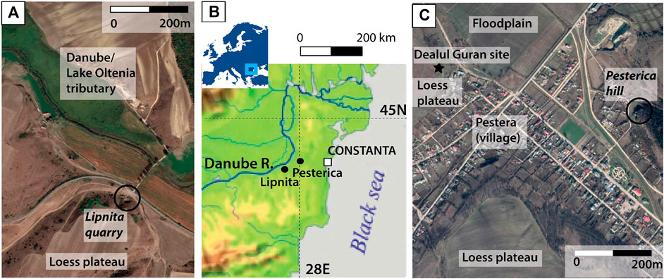
FIGURE 1. Location and contexts of the two localities discussed in this study: (A). Lipniţa quarry. (B). Location of the Dobrogea region and the sites near the lower Danube river. (C). Peşterica hill opposite the Lower Peolithic site of Dealul Guran.
DP is a previously reported site (Nicolăescu-Plopşor et al., 1959; Păunescu et al., 1972; Păunescu, 1999) located in central Dobrogea, close to the watershed of a tributary flowing west into the Danube and adjacent the village of Pestera (Figure 1C). The altitude of this location (c. 39 m above sea level) is comparable with that of Lipniţa 40 km west-southwest. The Lower Paleolithic workshop site of Dealul Guran, which contains evidence for Upper Paleolithic exploitation of surface-exposed limestone flints (Iovita et al., 2012), is located on the hill opposite. The DP locality encompasses the west-facing hillslope and is a complex of small rockshelters, sandstone and limestone bluffs overlain by mixed loess and colluvium of variable thickness. Since lithic assemblages had been documented at this site and sediment had been removed from most of the exposed rockshelters through recent use, our study focused on Paleolithic hominin traces within the sediments. Four sondages were excavated in a transect along the slope to document catenary change in the sediments, stratigraphic marker horizons such as the Campanian Ignimbrite tephra, and the occurrence of lithic artifacts.
Lithic Finds
In this study we are primarily interested in the incidence of artifacts as evidence of human presence in the landscape. We summarize what is known about the lithic assemblages at the two sites in Sedimentary Context of the Lipniţa Locality, and Antiquity of the Lithic Fragments and Age and Sedimentary Context of the Dealul Peşterica Finds.
At Lipniţa, only the two flakes found within the sediment block were identified. Both were embedded within red pedogenic sediment near the underlying contact with the basal fluvial gravels. Both lithics had relatively fresh surfaces, but were otherwise undiagnostic. No other lithics were found near the profile or on the surface of the loess plateau.
At DP, 187 lithic pieces (including 70 tools) collected from the surface by Păunescu (1999) were analyzed by Doboş (2010). Most of the retouched tools are non-cortical simple scrapers and thereby undiagnostic, although 3% bear similarity to Levallois technology. Artifacts found within the DP test excavations were recorded individually using measuring tape.
Luminescence Dating
Luminescence dating was undertaken to constrain the antiquity of the localities in question and, additionally at DP, to gain insight into the potential for relationships between artifacts along the catena. At DP, samples were collected by driving 10 cm long, 4 cm diameter stainless steel tubes horizontally into the excavated walls as close as possible to in situ lithics. The sediments in the shallow sondages three and four were unsuitable for dating due to bioturbation and were therefore not sampled. At Lipniţa, the block containing the lithic fragments was wrapped in plaster and transferred to the field station (Supplementary Figures 1 and 2), where the sediment was subsampled into blocks >10 cm in diameter for preparation in the laboratory. An additional, in situ tube sample was collected from the in situ lower red sediments directly in the profile at the stratigraphic equivalent of the block.
Samples were prepared for equivalent dose (De) measurement at the Max Planck Institute for Evolutionary Anthropology (Leipzig) under subdued red light. The sandy samples from Lipniţa were processed to extract the 180–212 µm quartz fraction for single-grain analysis according to published protocols (Fitzsimmons et al., 2014). The loessic DP sediments were processed to extract the 4–11 µm fine-grained fraction; the polymineral component was extracted following published protocols (Iovita et al., 2012), from which subsamples were etched to extract purified quartz (Timar et al., 2010). Further details relating to sample preparation and measurement can be found in the Supplementary. Dose rates were calculated based on beta counting, high resolution germanium gamma spectrometry (measured at VKTA in Dresden), published alpha dose-rate values (Rees-Jones and Tite, 1997) and cosmic ray dose rate formulae (Prescott and Hutton, 1994).
Results
Luminescence Dating at Dealul Peşterica and Lipniţa
The quartz fine-grained samples from DP appear suitable for dating using the SAR protocol (Supplementary Figures 6 and 7; Supplementary Table 1) and yield OSL characteristics comparable with loess in the Dobrogea region (Timar et al., 2010; Fitzsimmons and Hambach, 2014; Constantin et al., 2015). By contrast, the polymineral fine-grained DP samples were less well suited to the pIR-IRSL protocol and likely subject to signal fading (further details in Supplementary). Consequently the pIR-IRSL age for the sondage one sample (EVA1192) is assumed to give a minimum estimate; quartz ages were used for the other DP samples (Table 1).
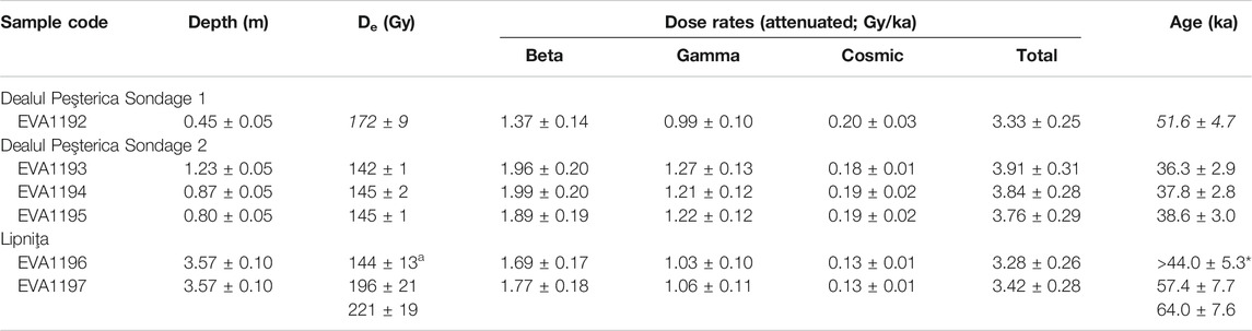
TABLE 1. Luminescence dating supporting data and age estimates for the sondages at Dealul Peşterica and both block and in situ samples from Lipniţa. Equivalent doses calculated using pIR-IRSL measurements on polymineral fine-grains (Buylaert et al., 2012) are shown in italics; those in plain text were measured using the SAR protocol on fine-grained quartz.
Sandy sediments from Dobrogea have rarely yielded reliable luminescence ages (Iovita et al., 2012; Anechitei-Deacu et al., 2014). However, the Lipniţa quartz sands produced good results (see Supplementary Material) which may be explained by a difference in sediment source from those investigated previously.
Table 1 summarizes the luminescence ages for the two localities. At DP, the age of the unit containing the lithic finds at sondage one is <51.6 ± 4.7 ka; at sondage two the deposition of lithics can be constrained to c. 34–41 ka (1σ). The Lipniţa artifacts are most likely c. 61 ka.
Sedimentary Context of the Lipniţa Locality, and Antiquity of the Lithic Fragments
Lipniţa is situated on the northern slope of a loess plateau adjacent the Suha Reka channel and its floodplain. Four major stratigraphic units, three of which include some degree of pedogenic development, are exposed within the profile (Figures 2A,B). Fluvial gravels at the base of the sequence include imbricated cobbles up to 7 cm diameter and indicate a northward flow direction, consistent with the present course of the Suha Reka. The size of larger clasts indicates a higher energy river than exists presently. Fluvial clasts are dominated by quartz and limestone, including flint-bearing calcareous material (Petrov and Yankov, 2017), infilled with a reddish clayey silt matrix similar to the overlying unit which may have been deposited during the initial stages of its deposition. We describe the overlying reddish clayey silts as “Red beds” (to disambiguate from the term paleosol used in Iovita et al., 2014). These unconformably overlie the basal gravels and comprise massive reddish clayey silts, minor sands, gravels and cobbles with some pedogenic development. The Red Beds are likely to be predominantly water-lain, with some eolian input, and may originally be derived from remobilization of Plio-Pleistocene clay-rich reposits found across the Danube Basin (Kovács et al., 2011). The Red Beds are unconformably overlain by two pale loess units, each with soil development, although there is nothing sufficiently distinctive about the loess or paleosols to justify correlation with the supra-regional stratigraphy (Fitzsimmons et al., 2012) without direct dating of the sediments. Unidentifiable bone fragments were observed at three places within the loess. The sequence at this locality indicates either progressive decrease in fluvial activity or lateral channel migration. The present-day ephemeral nature of the Suha Reka is due to deforestation within the catchment over 100 years ago; it now flows only during spring snow-melt or following major rainfall events (Telteu and Zaharia, 2012).
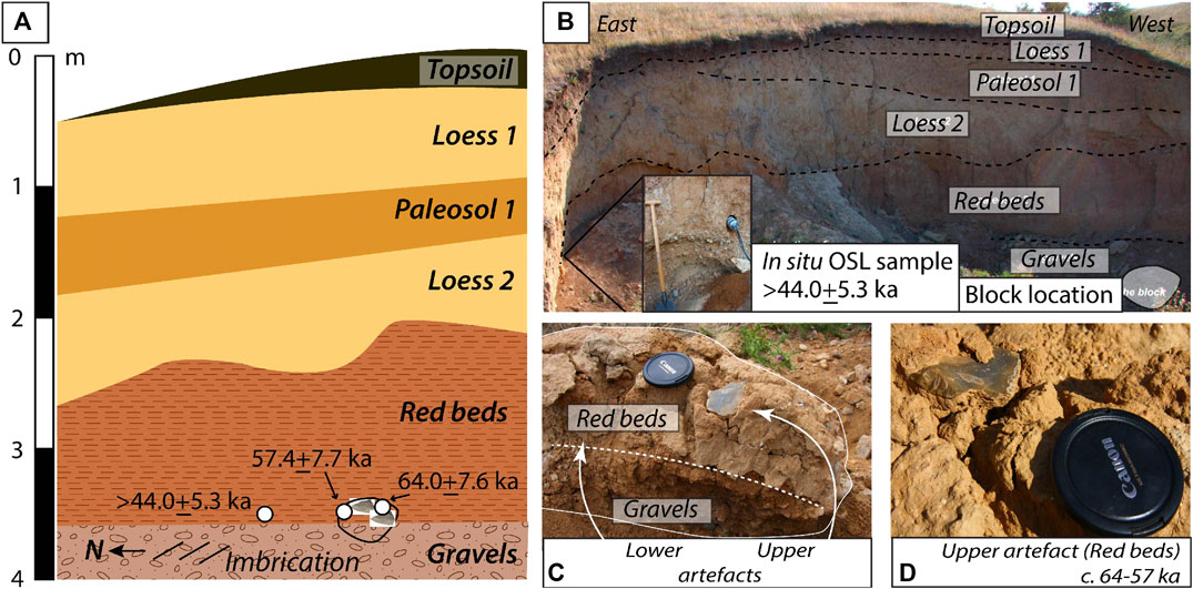
FIGURE 2. Chronostratigraphic information for Lipniţa. (A). Schematic overview of stratigraphy, dating and artifact context. (B). View of the profile looking south. (C). Sediment block with embedded artifacts. (D). The upper artifact within the Red beds.
The two lithic fragments excavated from the block (Figures 2C,D) were found embedded within the Red beds just above the contact with the basal gravels. The profile sample yielded a minimum age of >44.0 ± 5.3 ka, whereas the two subsamples collected from the block produced ages of 57.4 ± 7.7 and 64.0 ± 7.6 ka (Table 1). These ages fall within error of one another and indicate an antiquity for the lithics of c. 61 ka.
Age and Sedimentary Context of the Dealul Peşterica Finds
The hillslope surface at DP comprises several catenary sequences which assist in piecing together both stratigraphy and context of the archeological traces. The DP stratigraphy can be grouped into six stratigraphic units (Figure 3A; Supplementary Tables 5–9).
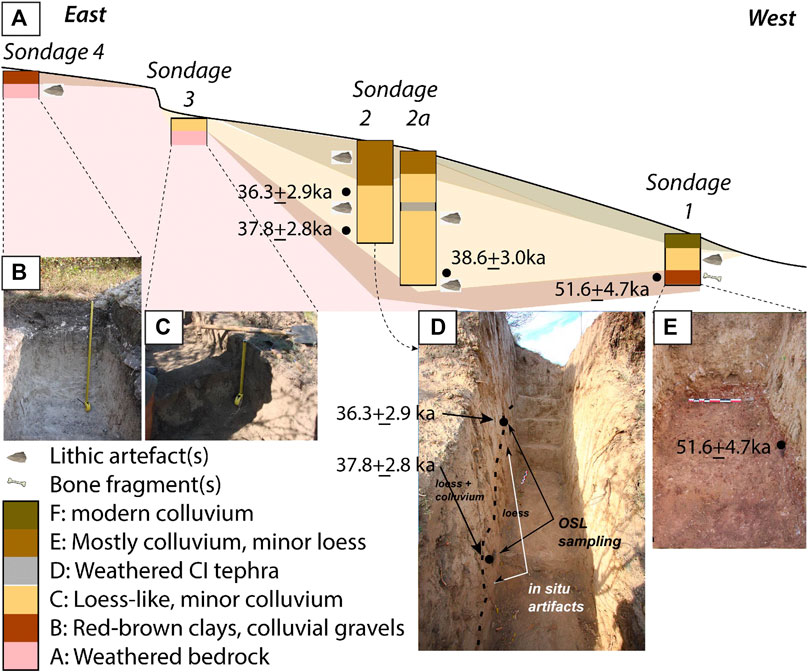
FIGURE 3. Chronostratigraphic information for Dealul Peşterica. (A). Overview of the stratigraphy and catenary relationships along the transect, including positions of artifacts and dating. (B–E). Photographs of the four sondages.
The underlying bedrock, comprising Cretaceous calcareous sandstones and limestones (Avram et al., 1993), is exposed between sondages 3 and 4, and was observed in weathered form at both test pits (Figures 3B,C).
At the top and bottom of the hill, the bedrock is overlain by clays of varying color (unit B), most likely representing a still more weathered, unconsolidated component of in situ regolith. At the top of the hill, this unit is pale, with a higher proportion of sand derived from the glauconitic sandstones. By contrast, unit B at sondage 1 is reddish-brown, with a higher clay component and substantial inmixing of slope-deposited colluvium. Genetically, however, the two are related and can be linked in a catena downslope. Lithics and raw material are scattered on the surface and within unit B at the top of the slope. While flint chips are common in unit B at sondage 1, none could be clearly attributed to human agency. Two undiagnostic bone fragments were also found in Unit B. This unit dates to at least 51.6 ± 4.7 ka (Figure 3E).
The mid-slope is dominated by pale, massive beige loess-like sediment, thicker on the northern slope than on the west and south, with colluvial clasts of flint and sandy limestone increasing in density downslope. This unit (C) dominates the sondages at position 2, and is thinner, and more colluvium-rich, in sondages 1 and 3 due to slope aspect and position along the slope. Flint fragments were found at low density within this unit, including five which could be confidently attributed to human activity at sondage 2, and four in sondage 1. Three ages, spanning 38.6 ± 3.0 to 36.3 ± 3.9 ka (Figures 3A,D), indicate rapid deposition of sediment at this time. At a side trench (sondage 2a), a thin, discontinuous weathered tephra was observed, interpreted to be the Campanian Ignimbrite; its known age (39.28 ± 0.11 ka; De Vivo et al., 2001) lies within uncertainty of the OSL ages.
Unit C is overlain at sondage 2 by a darker beige stratum (unit E) comprising a mix of colluvium and loess, dominated by the former. Two lithics attributed to human activity were observed within this unit, although evidence for substantial bioturbation in unit E prevented reliable luminescence sampling. The uneven contact between Units C and E suggests a short-lived erosional event followed by increasing dominance of slope deposition. Mass movement continues on the lower slopes as demonstrated by c. 20 cm of modern colluvium at Sondage 1.
Discussion
Human use of Riverine Landscapes, but Not as Early as Thought: Lipniţa
According to conventional archeological thinking, the occurrence of two lithic artifacts at Lipniţa barely qualifies it as a site, although the actual artifact density could be much greater following future excavation. Through the unprejudiced perspective of off-sites, we may draw a number of conclusions from Lipniţa.
We may deduce that humans were present in the riparian landscape of the Suha Reka approximately c. 61 kyr ago. The artefact-bearing Red beds indicate a lower energy stream or swampy environment deposited during cool stadial conditions of marine isotope stage (MIS) 4, which succeeded a warm, wet interglacial. Transition from a high to lower energy stream is visible in the stratigraphy at Lipniţa, and is compatible with reduced hydrologic activity associated with the MIS4 stadial. In southeastern Romania, there is evidence at this time for spatially discontinuous peaks in loess accumulation (Timar-Gabor et al., 2011; Vasiliniuc et al., 2011; Constantin et al., 2014; Fitzsimmons, 2017), although dust deposition at Lipniţa initiated later.
The fresh surfaces of and lack of patina on the two lithics suggest that the artifacts were not fluvially transported but rather either discarded in situ (e.g., Delpiano et al., 2019), or transported only a very short distance. Given that flint cobbles up to 7 cm diameter are present in the basal gravels, it is possible that these provided the raw material for flake production, although flint outcrops are common in the karst gorge upstream.
The c. 61 ka age of the Lipniţa lithics is younger than anticipated. The paleosol preserved between the two loess units bears similarity to MIS5 interglacial loess soils (Fitzsimmons et al., 2012), and Iovita et al. (2014) surmised that deposition of the Red beds, and their artifacts predated MIS5. In this respect we can only emphasize the importance of direct dating.
We cannot infer much more about human behavior in this area without further excavation, however we can aggregate information about the distribution of people across the landscape at a given time. Another open-air locality of similar antiquity, yielding ca. 1,300 surface lithics, is Cuza Vodă E (Păunescu, 1999), 60 km northeast of Lipniţa. In situ lithic material at Cuza Vodă, also found at the contact with fluvial red beds, date to c. 95–55 ka (Iovita et al., 2014). Intriguingly, both environmental context and age are similar. Cuza Vodă site lies just north of the palaeo-Carasu River, another Dobrogea tributary of the Danube (Zaharia and Pisota, 2003). At this stage there are no other known localities of this age in Dobrogea, but incremental aggregation of datasets like these may eventually yield more useful information about human habitat preferences.
The Human Catena, and Life in Open-air Contexts: Dealul Peşterica
Unlike Lipniţa, DP is a reported site with at least 70 tools, albeit very few of which resemble known technocomplexes (Doboş, 2010). Our sondages confirmed a further nine lithics altered by human agency along the slope, further establishing human presence in the area in the deep past. Through an orthodox archeological lens, however, the density of lithics is low and more consistent with an off-site. Considering these traces nevertheless provides new avenues for understanding human use of the landscape.
Here we invoke the catena concept for understanding the stratigraphy at DP, its archeological traces, and their antiquity. A catena is a sequence of soil profiles of varying characteristics that occur down a slope, and sometimes contains Paleolithic finds (Łanczont et al., 2015). At least two catenas can be identified at DP: units B and C. Unit B is discontinuous, since it was observed only at the top and bottom of the slope. We conclude that the bone and lithic fragments in unit B at the base of the hill, dated to 51.6 ± 4.7 ka (or possibly slightly older), are likely the same age as those found in its equivalent on the hilltop. Although none of the artifacts found in situ within this unit are recognisable tools, and they are certainly lithic manuports, it is interesting that the timing of deposition of this unit closely postdates human presence at Lipniţa.
Greater meaning can be derived from in the overlying loessic unit C. The character of this unit likewise varies along slope, nevertheless its stratigraphic position remains consistent. We can argue that unit C dates to c. 41–34 ka, within interstadial MIS3. Furthermore, at least two visits by people—demonstrated by two lithics found below the tephra—shortly predate the Campanian Ignimbrite super-eruption which may have substantially impacted on people in the region (Fitzsimmons et al., 2013). As yet, there are few known archeological sites in Dobrogea dating to this time, with the exception of Cheia–La Izvor, which dates to c. 40 kcal BP (Păunescu, 1999). Most of the Paleolithic finds in Dobrogea (>100 loci) derive from surface find spots, ranging from 1 to >100 pieces (Păunescu, 1999; Doboş et al., 2005; Iovita et al., 2014). The few sites with stratigraphy vary in assemblage size, depending on the site function. In the absence of ideal sites, an incremental approach which places human presence on the map (e.g., Delpiano et al., 2019) removes some uncertainty regarding human occupation at the gateway to Europe at this critical time.
Our approach allows tentative steps toward understanding the nature of Paleolithic mobility and taskscape (Ingold, 1993). The entire hillslope of DP yields evidence for human presence. Sub-millimeter air pockets within unit C at the mid-slope indicate rapid deposition; coupled with low artifact density, we may infer infrequent visitation of the area by people rather than continuous occupation. Examinations of vast surface records in Australia (Holdaway and Davies, 2019) and Egypt (Olszewski et al., 2010) have shown that many activities involving the use of stone tools takes place off-“site,” although such loci of activity are rarely captured in environments with high sedimentation rates. One could argue that rather than confining themselves to a defined occupational area, people ranged over landscape scales, particularly where raw material for making stone tools was plentiful (e.g., Iovita et al., 2012). Such observations, while intuitive, are rarely supported by evidence (but see Zerboni et al., 2015; Delpiano et al., 2019, for a similar case in northern Italy). At DP, we may start to build a case for this hypothesis.
Applicability of Off-Sites to Geoarcheology in Challenging Open-air Situations
In reality, few sites provide all details sought for meaningful integration between paleoenvironmental and archeological datasets. However, in the search for localities, information from less impressive, ephemeral contexts may be overlooked (see also Foley, 1981; Glauberman, 2006). Here we argue for more careful consideration of the latter. Understanding Paleolithic mobility at landscape scales requires both nodes of dense interaction (sites) and networks of taskscape traces (Rezek et al., 2020).
Using case studies from the understudied, yet highly strategic region of Dobrogea, we demonstrate that empirical, incremental conclusions may still be drawn from sites typically thought to be of little value. Geochronology is an essential tool both for marking the presence of people at key times and for refuting chronologies inferred from regional correlations. Particularly in sediment-rich open-air contexts, people likely ranged over large areas particularly when raw material for making stone tools was widespread as in Dobrogea. We suggest that aggregating information from off-sites can further help us understand the human implications for landscape context through their traces.
Data Availability Statement
The datasets generated by this study can be found in Edmond, the Open Access Data Repository of the Max Planck Society (https://edmond.mpdl.mpg.de).
Author Contributions
KF conceived of the presented ideas in this study; RI developed the Lower Danube Survey for Paleolithic Sites project as a whole. RI and AD oversaw the archeological fieldwork, which was undertaken by AD, MP, and RI. Interpretation of the archeological results was undertaken by AD and RI. KF undertook the geological fieldwork and laboratory analyses. KF wrote the first draft of the manuscript. All authors contributed to manuscript revision, read and approved the submitted version.
Funding
The field and laboratory components of this study were funded by the Max Planck Institute for Evolutionary Anthropology as part of the Lower Danube Survey for Paleolithic Sites (LoDanS).
Conflict of Interest
The authors declare that the research was conducted in the absence of any commercial or financial relationships that could be construed as a potential conflict of interest.
Acknowledgments
The authors thank Professor J.-J Hublin and S. McPherron for their support of the Lower Danube Survey for Paleolithic sites project. Fieldwork was undertaken according to Romanian law and within the terms of permit 1/2011 granted by the Ministry of Culture of Romania (permit holders R. Dobrescu, V. V. Zirra, Institute of Archaeology “Vasile Pârvan” of the Romanian Academy), with German partners the Max Planck Institute for Evolutionary Anthropology and Römisch-Germanisches Zentralmuseum Mainz (RGZM-Monrepos). Thanks to S. Hesse for her assistance with luminescence dating sample preparation, and to students from the prehistory programme at the Johannes Gutenberg University Mainz for their assistance in the field.
Supplementary Material
The Supplementary Material for this article can be found online at: https://www.frontiersin.org/articles/10.3389/feart.2020.561207/full#supplementary-material
Nomenclature
De, equivalent dose; DP, Dealul Peşterica (locality); OSL, Optically stimulated luminescence; pIR-IRSL, Post-InfraRed InfraRed Stimulated Luminescence
References
Anechitei-Deacu, V., Timar-Gabor, A., Fitzsimmons, K., Veres, D., and Hambach, U. (2014). Multi-method luminescence investigations on quartz grains of different sizes extracted from a loess section in Southeast Romania interbedding the Campanian Ignimbrite ash layer. Geochronometria 41, 1–14. doi:10.2478/s13386-013-0143-4
Avram, E., Szasz, L., Antonescu, E., Baltreš, A., Iva, M., Melinte, M., et al. (1993). Cretaceous terrestrial and shallow marine deposits in northern South Dobrogea (SE Rumania). Cretac. Res. 14 (3), 265–305. doi:10.1006/cres.1993.1022
Bintliff, J. L. (2000). “The concepts of “site” and “off-site” archaeology in surface artefact survey,” in Non-destructive techniques applied to landscape Archaeology: The Archaeology of Mediterranean landscapes. Editors M. Pasquinucci and F. Trément (Oxford, UK: Oxbow Books), Vol. 4, 200–215.
Buylaert, J.-P., Jain, M., Murray, A. S., Thomsen, K. J., Thiel, C., and Sohbati, R. (2012). A robust feldspar luminescence dating method for Middle and Late Pleistocene sediments. Boreas 41 (3), 435–451. doi:10.1111/j.1502-3885.2012.00248.x
Chu, W. (2018). The Danube corridor hypothesis and the Carpathian basin: geological, environmental and archaeological approaches to Characterizing Aurignacian dynamics. J. World Prehist. 31, 117–178. doi:10.1007/s10963-018-9115-1
Conard, N. J., and Bolus, M. (2003). Radiocarbon dating the appearance of modern humans and timing of cultural innovations in Europe: new results and new challenges. J. Hum. Evol. 44 (3), 331–371. doi:10.1016/s0047-2484(02)00202-6
Constantin, D., Begy, R., Vasiliniuc, S., Panaiotu, C., Necula, C., Codrea, V., et al. (2014). High-resolution OSL dating of the Costineşti section (Dobrogea, SE Romania) using fine and coarse quartz. Quat. Int. 334-335, 20–29. doi:10.1016/j.quaint.2013.06.016
Constantin, D., Cameniţă, A., Panaiotu, C., Necula, C., Codrea, V., and Timar-Gabor, A. (2015). Fine and coarse-quartz SAR-OSL dating of last glacial loess in southern Romania. Quat. Int. 357, 33–43. doi:10.1016/j.quaint.2014.07.052
Davison, K., Dolukhanov, P., Sarson, G. R., and Shukurov, A. (2006). The role of waterways in the spread of the Neolithic. J. Archaeol. Sci. 33, 641–652. doi:10.1016/j.jas.2005.09.017
De Vivo, B., Rolandi, G., Gans, P. B., Calvert, A., Bohrson, W. A., Spera, F. J., et al. (2001). New constraints on the pyroclastic eruptive history of the Campanian volcanic Plain (italy). Mineral. Petrol. 73, 47–65.
Delpiano, D., Peresani, M., Bertola, S., Cremaschi, M., and Zerboni, A. (2019). Lashed by the wind: short-term middle palaeolithic occupations within the loess-palaeosoil sequence at Monte Netto (northern Italy). Quat. Int. 502, 137–147. doi:10.1016/j.quaint.2019.01.026
Doboş, A. (2010). Paleoliticul mijlociu de pe teritoriul de la sud si sud-est de Carpati (Oltenia, Muntenia, Dobrogea) (in Romania). Bucharest, Romania: Institute of Archaeology “Vasile Pârvan”, 289.
Doboş, A., Iacob, M., and Paraschiv, D. (2005). Paleolithic discoveries in northern Dobrogea. Prehistoric Studies 2, 215–219 [in Romanian, with English summary].
Doboş, A., and Iovita, R. (2016). “The lower paleolithic of Romania revisited: new evidence from the site of Dealul Guran,” in Paleoanthropology of the Balkans and Anatolia. Editors K. Harvati and M. Roksandic (Dordrecht, Netherlands: Springer Netherlands), 171–186.
Fedele, F. G., Giaccio, B., and Hajdas, I. (2008). Timescales and cultural process at 40,000BP in the light of the Campanian ignimbrite eruption, Western Eurasia. J. Hum. Evol. 55 (5), 834–857. doi:10.1016/j.jhevol.2008.08.012
Fitzsimmons, K., Hambach, U., Veres, D., and Iovita, R. (2013). The Campanian Ignimbrite eruption: new data on volcanic ash dispersal and its potential impact on human evolution. PloS One 8 (6), e65839. doi:10.1371/journal.pone.0065839
Fitzsimmons, K. E. (2017). Reconstructing palaeoenvironments on desert margins: new perspectives from Eurasian loess and Australian dry lake shorelines. Quat. Sci. Rev. 171, 1–19. doi:10.1016/j.quascirev.2017.05.018
Fitzsimmons, K. E., and Hambach, U. (2014). Loess accumulation during the last glacial maximum: evidence from Urluia, southeastern Romania. Quat. Int. 334–335, 74–85. doi:10.1016/j.quaint.2013.08.005
Fitzsimmons, K. E., Marković, S. B., and Hambach, U. (2012). Pleistocene environmental dynamics recorded in the loess of the middle and lower Danube basin. Quat. Sci. Rev. 41, 104–118. doi:10.1016/j.quascirev.2012.03.002
Fitzsimmons, K. E., Stern, N., and Murray-Wallace, C. V. (2014). Depositional history and archaeology of the central Lake Mungo lunette, Willandra Lakes, southeast Australia. J. Archaeol. Sci. 41, 349–364. doi:10.1016/j.jas.2013.08.004
Foley, R. A. (1981). “Off-site archaeology: an alternative approach for the short-sited,” in Pattern of the past: studies in honour of David Clarke. Editor Harmond, N. (Cambridge, UK: Cambridge University Press), 157–183.
Glauberman, P. (2006). “Excavating surface sites, tapping a source of potential: the Middle Palaeolithic surface scatters of southern Limburg (NL) and the case study of Colmont-Ponderosa,” in Preserving the early past: investigation, selection and preservation of palaeolithic and mesolithic sites and landscapes, Nederlandse Archeologische Rapporten. Editors E. Rensink and H. Peeters (Amersfoort, Netherlands: National Service for Archaeological Heritage), 87–106.
Hauck, T. C., Lehmkuhl, F., Zeeden, C., Bösken, J., Thiemann, A., and Richter, J. (2018). The Aurignacian way of life: Contextualizing early modern human adaptation in the Carpathian Basin. Quat. Int. 485, 150–166. doi:10.1016/j.quaint.2017.10.020
Holdaway, S. J., and Davies, B. (2019). Surface stone artifact scatters, settlement patterns, and new methods for stone artifact analysis. Journal of Paleo. Arch. 1–21. doi:10.1007/s41982-019-00030-8
Ingold, T. (1993). The temporality of the landscape. World Archaeol. 25, 152–174. doi:10.1080/00438243.1993.9980235
Iovita, R., Doboş, A., Fitzsimmons, K. E., Probst, M., Hambach, U., Robu, M., et al. (2014). Geoarchaeological prospection in the loess steppe: preliminary results from the lower Danube survey for paleolithic sites (LoDanS). Quat. Int. 351, 98–114. doi:10.1016/j.quaint.2013.05.018
Iovita, R., Fitzsimmons, K. E., Doboş, A., Hambach, U., Hilgers, A., and Zander, A., (2012). Dealul Guran: evidence for Lower Palaeolithic (MIS 11) occupation of the Lower Danube loess steppe. Antiquity 86, 973–989. doi:10.1017/s0003598x00048195
Iovita, R., Varis, A., Namen, A., Cuthbertson, P., Taimagambetov, Z., and Miller, C. E. (Forthcoming 2020). In search of a paleolithic silk road in Kazakhstan. Quat. Int. doi:10.1016/j.quaint.2020.02.023
Kovács, J., Fábián, S. Á., Varga, G., Újvári, G., Varga, G., and Dezso, J. (2011). Plio-Pleistocene red clay deposits in the Pannonian basin: a review. Quat. Int. 240 (1-2), 35–43. doi:10.1016/j.quaint.2010.12.013
Krajcarz, M. T., Kot, M., Pavlenok, K., Fedorowicz, S., Krajcarz, M., Lazarev, S. Y., et al. (2016). Middle Paleolithic sites of Katta Sai in western Tian Shan piedmont, Central Asiatic loess zone: Geoarchaeological investigation of the site formation and the integrity of the lithic assemblages. Quat. Int. 399, 136–150. doi:10.1016/j.quaint.2015.07.051
Łanczont, M., Madeyska, T., Sytnyk, O., Bogucki, A., Komar, M., Nawrocki, J., et al. (2015). Natural environment of MIS 5 and soil catena sequence along a loess slope in the Seret River valley: evidence from the Pronyatyn Palaeolithic site (Ukraine). Quat. Int. 365, 74–97.
Lowe, J., Barton, N., Blockley, S., Ramsey, C. B., Cullen, V. L., Davies, W., et al. (2012). Volcanic ash layers illuminate the resilience of Neanderthals and early modern humans to natural hazards. Proc. Natl. Acad. Sci. Unit. States Am. 109(34), 13532–13537. doi:10.1073/pnas.1204579109
Mihailović, D. (2020). Push-and-pull factors of the middle to upper paleolithic transition in the balkans. Quat. Int. 551, 47–62. doi:10.1016/j.quaint.2019.10.010
Morgan, C., Barton, L., Bettinger, R., Chen, F., and Dongju, Z. (2011). Glacial cycles and palaeolithic adaptive variability on China’s Western Loess Plateau. Antiquity 85, 365–379. doi:10.1017/s0003598x00067818
Murray, A. S., and Wintle, A. G. (2000). Luminescence dating of quartz using an improved single-aliquot regenerative-dose protocol. Radiat. Meas. 32 (1), 57–73. doi:10.1016/s1350-4487(99)00253-x
Neagu, F. (1961). Die Donau als Schicksalsstrom des Osmanenreiches. (Munich, Germany: Südosteuropa-Jahrbuch), 5, 15–27 [in German].
Nicolăescu-Plopşor, C. S., Păunescu, A., and Bolomey, A. (1959). Raport preliminar asupra cercetarilor paleolitice din anul 1956. Materiale si cercetari arheologice 5, 15–43 [in Romanian]. doi:10.3406/mcarh.1959.1129
Obreht, I., Hambach, U., Veres, D., Zeeden, C., Bösken, J., Stevens, T., et al. (2017). Shift of large-scale atmospheric systems over Europe during late MIS 3 and implications for Modern Human dispersal. Sci. Rep. 7, 5848. doi:10.1038/s41598-017-06285-x
Olszewski, D. I., Dibble, H. L., McPherron, S. P., Schurmans, U. A., Chiotti, L., and Smith, J. R. (2010). Nubian Complex strategies in the Egyptian high desert. J. Hum. Evol. 59, 188–201. doi:10.1016/j.jhevol.2010.06.001
Papasima, T. (1993). Cronica cercetărilor arheologice din românia, Campania 1983 - 1992. Bucharest, Romania: CIMEC - institutul de Memorie Culturala.
Păunescu, A. (1999). Paleoliticul si Mezoliticul de pe teritoriul Dobrodgei. Bucharest, Romania: Editura Satya Sai [in Romanian].
Păunescu, A., Mogosanu, F., and Cârciumaru, M. (1972). Unele considerat¸ ii privind paleoliticul mijlociu din Dobrogea. Pontica 5, 11–28 [in Romanian].
Petrov, G., and Yankov, R. (2017). ПРИМЕРЕН ГЕОГРАФСКИ ПОДЧОД ПРИ РАЗРАБОТВАНЕТО НА ПРОГНОЗЕН АРЧЕОЛОГИЧЕСКИ МОДЕЛ (An exemplary geographic approach to developing a predicative archaeological model). ЕПОЧИ (Epochs) 1, 120–127 [in Bulgarian, with English summary].
Prescott, J. R., and Hutton, J. T. (1994). Cosmic ray contributions to dose rates for luminescence and ESR dating: large depths and long-term time variations. Radiat. Meas. 23, 497–500. doi:10.1016/1350-4487(94)90086-8
Rees-Jones, J., and Tite, M. S. (1997). Optical dating results for British archaeological sediments. Archaeometry 39, 177–187. doi:10.1111/j.1475-4754.1997.tb00797.x
Rezek, Z., Holdaway, S. J., Olszewski, D. I., Lin, S. C., Douglass, M., McPherron, S. P., et al. (2020). Aggregates, formational emergence, and the focus on practice in stone artifact archaeology. J. Archaeol. Method Theor. 1–42.
Richter, J., Hauck, T., Vogelsang, R., Widlok, T., Le Tensorer, J.-M., and Schmid, P. (2012). “Contextual areas” of early Homo sapiens and their significance for human dispersal from Africa into Eurasia between 200 ka and 70 ka. Quat. Int. 274, 5–24. doi:10.1016/j.quaint.2012.04.017
Romanowska, I. (2012). “Lower Palaeolithic of central and Eastern Europe: critical evaluation of the current state of knowledge,” in Unravelling the palaeolithic. 10 years of research at the Centre for the Archaeology of human origins (British archaeological Reports). Editors K. Ruebens, I. Romanowska, and R. Bynoe (Oxford, UK: Archaeopress), 1–12.
Schmidt, C., Anghelinu, M., Hambach, U., Veres, D., and Lehmkuhl, F. (2020). Reassessing the timeframe of upper palaeolithic deposits in the Ceahlău basin (Eastern Carpathians, Romania): Geochronological and archaeological implications. Quat. Geochronol. 55, 101020. doi:10.1016/j.quageo.2019.101020
Schmidt, C., Sitlivy, V., Anghelinu, M., Chabai, V., Kels, H., Uthmeier, T., et al. (2013). First chronometric dates (TL and OSL) for the Aurignacian open-air site of Româneşti-Dumbrăviţa I, Romania. J. Archaeol. Sci. 40 (10), 3740–3753. doi:10.1016/j.jas.2013.04.003
Sitlivy, V., Chabai, V. P., Anghelinu, M., Uthmeier, T., Kels, H., Hilgers, A., et al. (2012). The earliest Aurignacian in Romania: new investigations at the open air site of Româneşti-Dumbrăviţa I (Banat). Quartär 59, 85–130.
Stephenson, P. (1999). “The byzantine frontier at the lower Danube in the late tenth and eleventh Centuries,” in Frontiers in question: eurasian Borderlands, 700–1700. Editors D. Power and N. Standen (London, UK: Macmillan Education UK), 80–104.
Telteu, C.-E., and Zaharia, L. (2012). Morphometrical and dynamical features of the South Dobrogea lakes, Romania. Procedia Environmental Sciences 14, 164–176. doi:10.1016/j.proenv.2012.03.016
Timar, A., Vandenberghe, D., Panaiotu, E. C., Panaiotu, C. G., Necula, C., Cosma, C., et al. (2010). Optical dating of Romanian loess using fine-grained quartz. Quat. Geochronol. 5 (2-3), 143–148. doi:10.1016/j.quageo.2009.03.003
Timar Gabor, A., Vandenberghe, D., Vasiliniuc, S., Panaiotu, C., Panaiotu, C., Dimofte, D., et al. (2011). Optical dating of Romanian loess: a comparison between silt-sized and sand-sized quartz. Quat. Int. 240 (1-2), 62–70. doi:10.1016/j.quaint.2010.10.007
Tourloukis, V. (2016). “On the spatio-temporal distribution of Mediterranean lower paleolithic sites: a Geoarchaeological perspective,” in Paleoanthropology of the Balkans and Anatolia: human evolution and its context, vertebrate paleobiology and paleoanthropology. Editors K. Harvati and M. Roksandic (Dordrecht, Netherlands: Springer Netherlands), 303–323.
Vasiliniuc, Ş., Timar‐Gabor, A., Vandenberghe, D. A. G., Panaiotu, C. G., Begy, R., and Cosma, C. (2011). A high resolution optical dating study of the Mostiştea loess-palaeosol sequence (SE Romania) using sand-sized quartz. Geochronometria 38 (1), 34–41.
Veres, D., Lane, C. S., Timar-Gabor, A., Hambach, U., Constantin, D., Szakács, A., et al. (2013). The Campanian Ignimbrite/Y5 tephra layer - a regional stratigraphic marker for isotope Stage 3 deposits in the Lower Danube region, Romania. Quat. Int. 293, 22–33. doi:10.1016/j.quaint.2012.02.042
Verhagen, P., Rensink, E., Bats, M., and Crombé, P. (2013). Establishing discovery probabilities of lithic artefacts in Palaeolithic and Mesolithic sites with core sampling. J. Archaeol. Sci. 40, 240–247. doi:10.1016/j.jas.2012.05.041
Versaggi, N. M., and Hohman, C. D. (2008). Small lithic sites: linking significance with context. Current approaches to the analysis and interpretation of small lithic sites in the northeast, 175–186.
Zaharia, L., and Pisota, I. (2003). “Apele dobrogei,” in: Geografie. Bucharest, Romania: Analele Universitatii Bucuresti, 107–144 [in Romanian].
Zerboni, A., Trombino, L., Frigerio, C., Livio, F., Berlusconi, A., Michetti, A. M., et al. (2015). The loess-paleosol sequence at Monte Netto: a record of climate change in the Upper Pleistocene of the central Po Plain, northern Italy. J. Soils Sediments 15, 1329–1350. doi:10.1007/s11368-014-0932-2
Keywords: loess, archeological prospection, catena, Dobrogea, Romania, Danube
Citation: Fitzsimmons KE, Doboş A, Probst M and Iovita R (2020) Thinking Outside the Box at Open-Air Archeological Contexts: Examples From Loess Landscapes in Southeast Romania. Front. Earth Sci. 8:561207. doi: 10.3389/feart.2020.561207
Received: 11 May 2020; Accepted: 03 September 2020;
Published: 23 October 2020.
Edited by:
Verena E. Foerster, University of Cologne, GermanyReviewed by:
Andrea Zerboni, University of Milan, ItalyNadia Solovieva, University College London, United Kingdom
Copyright © 2020 Fitzsimmons, Doboş, Probst and Iovita. This is an open-access article distributed under the terms of the Creative Commons Attribution License (CC BY). The use, distribution or reproduction in other forums is permitted, provided the original author(s) and the copyright owner(s) are credited and that the original publication in this journal is cited, in accordance with accepted academic practice. No use, distribution or reproduction is permitted which does not comply with these terms.
*Correspondence: Kathryn E. Fitzsimmons, ay5maXR6c2ltbW9uc0BtcGljLmRl