 Konglan Shao1,2
 Jianping Zhang
 Can Wang
 Houyuan Lu
- 1Key Laboratory of Cenozoic Geology and Environment, Institute of Geology and Geophysics, Chinese Academy of Sciences, Beijing, China
- 2University of Chinese Academy of Sciences, Beijing, China
- 3Innovation Academy for Earth Science, Chinese Academy of Sciences, Beijing, China
- 4Department of Archaeology, School of History and Culture, Shandong University, Jinan, China
Wetlands were important resources for the hunting–gathering and early farming communities in coastal areas in the Neolithic. However, the relationship between the development of the wetland environment and the human population remains unclear due to the lack of successive wetland environmental changes throughout the Holocene in coastal areas. Here, the summed probability distributions (SPD) of radiocarbon dates of peat were used as an indicator and combined with archaeological radiocarbon dates to reconstruct the wetland environmental and demographic changes during the Neolithic in the lower Yangtze region. The results showed that the shifts in demographic centers and population development were related to wetland environment with peat formation. The first shift of the demographic center was from the hilly regions to the coastal plain and occurred during ca. 8,300–8,000 cal yr BP, which might be caused by the attractiveness of survival resources offered by the coastal wetland environment and the 8.2 ka event. The second shift occurred from the Ningshao Plain to the Taihu region and might be attributed to the widespread waterlogged environment in the Ningshao Plain. The peak of demographic development coincided with the peak of peat formation during the middle Holocene in the lower Yangtze region, indicating that the wetland environment facilitated changes in human societies. The formation of peat might be related to the sea-level and El Niño-Southern Oscillation events; however, further studies are required for deep comprehension. The present study is an attempt at identifying the past impacts of the wetland environment on demographic development and can form the basis for a more comprehensive understanding of the interactions between the humans and their living environment.
Introduction
The lower Yangtze region is characterized as one of the flourish Neolithic cultural centers and early agricultural centers (Jiang and Liu, 2006; Liu et al., 2017; Zuo et al., 2017). Since ancient times, the region is strongly influenced by environmental changes such as climate changes, extreme climate events, and sea-level fluctuations (Innes et al., 2014; Patalano et al., 2015; He et al., 2018; Yang et al., 2020) as it is located in the boundary between the sea and the land. Studies on largescale environmental changes and human society developments aid the understanding of general rules about the evolution of human society through environmental changes. In addition, for specific sites, studying regional characteristic environmental changes and regional settlement shifts is also fundamental for comprehending human–climate–ecosystem interactions.
Wetlands are vital ecosystems in coastal areas, especially for prehistoric people, as they are valuable sources of food, and provide suitable conditions for farming (Ma et al., 2020; Zhang et al., 2020). Indeed, previous studies indicate that wetland environment attracted Neolithic people (Chen et al., 2008; Zong et al., 2011); however, the exact relationship between the evolution of the wetland environment and human activities remains unclear due to the lack of successive wetland environment reconstruction during the Holocene. In coastal areas, peat has been used as indicators of sea-level or floods in previous studies (Zhao et al., 1979; Törnqvist et al., 2004; Zhang et al., 2004; Zong, 2004; Zhang et al., 2005; Zhan and Wang, 2014; Brain et al., 2017; Hijma and Cohen, 2019). However, peat is one of wetlands products that is formed in flat terrain and relatively calm water environment (Chai, 1990; Lang et al., 1999; Mitsch and Gosselink, 2015). Furthermore, the exact time of peat formation can be directly dated as the primary organic element sources from in situ plant materials (Chai, 1990; Brain et al., 2017). The direct peat dating can refrain the anomalous radiocarbon dates caused by reworked sediments, which is a prevalent problem in the lower Yangtze region (Stanley and Chen, 2000; Li et al., 2014; Long et al., 2016).
In recent years, the summed probability distributions (SPD) of archaeological radiocarbon dates have been widely used to explore demographic changes (Shennan et al., 2013; Wang et al., 2014a; Goldberg et al., 2016; Bevan et al., 2017; Xu et al., 2019; Dong et al., 2020). In fact, not only the archaeological radiocarbon dates can reflect human population evolution, but also the temporal radiocarbon frequency distributions of environmental indicators are meaningful for environmental changes (Michczyńska et al., 2007; Wang et al., 2014b; Guo et al., 2018). Like the basis for SPD of archaeological radiocarbon dates to reflect the demographic changes, the high frequency of the environmental indicators always means good development and widespread of the corresponding environment. In previous studies, high probability distributions of radiocarbon dates of peat were used to indicate humid and moderate climate or the coaction of climate and sea-level changes (Michczyńska and Pazdur, 2004; Michczyńska et al., 2007; Dommain et al., 2011), whereas high SPD of peat directly indicates the large and contemporary formation of the corresponding wetland environment.
Here, we first attempt at using SPD of radiocarbon dates of peat to reconstruct successive wetland environmental changes and compare them with the demographic changes reflected by the SPD of archaeological radiocarbon dates to discuss the impacts of the regional wetland environmental changes on the development of the Neolithic human population in the lower Yangtze region. Further, we speculate the possible environmental backgrounds of peat formation to increase the predictability of coastal environment. The results provide a regional perspective on human-environment interactions that contribute to a deeper comprehension of human adaption to the environment, which may help generate sustainable human strategies pertaining to human development in the future.
Neolithic Archeological Background
The lower Yangtze region is one of the Chinese Neolithic cultural communities and an important origin center of Chinese civilization (Su and Yin, 1981; Yan, 1987). Shangshan Culture (11,000–8,500 years BP) is the earliest Neolithic culture in the lower Yangtze region, which is distributed primarily in the Jinqu Basin. Most sites of Shangshan Culture are in the center of the basin, close to the tributaries and before the hills, facilitating hunting and gathering in the region (Xu et al., 2016; Xu et al., 2020). Kuahuqiao Culture (8,300–7,200 years BP) is distributed primarily on the Qiantang River, which is the transition culture from mountain culture to river mouth culture (Jiang, 2014). The core area of Hemudu Culture (7,000–5,000 years BP) is the Ningshao Plain, a low-lying coastal plain. Research indicates that the Hemudu Culture is in the early period of rice cultivation, although the gathering and hunting economy still have their place (Fuller et al., 2009; Center for the Study of Chinese Archaeology, Peking University and Zhejiang Province Institute of Relics Archaeology, 2011). Majiabang Culture (7,000–5,800 years BP), Songze Culture (5,800–5,300 years BP), Liangzhu Culture (5,300–4,300 years BP), and Qianshanyang-Guangfulin Culture (4,300–3,900 years BP) are primarily distributed in the Taihu region, a coastal plain in the north of the Qiantang River (Institute of Archaeology, China Academy of Social Sciences, 2010; Cultural Relics and Archaeology Institute of Zhejiang Province, Huzhou Museum, 2014; Shanghai Museum, 2014; Zhejiang Provincial Institute of Cultural Relics and Archaeology, 2019) (Figure 1).
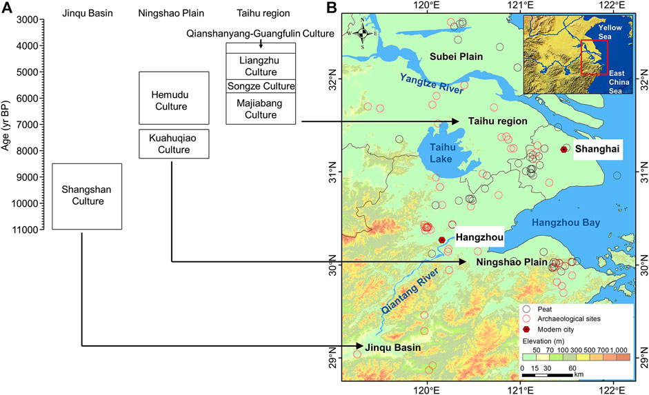
FIGURE 1. Temporal and spatial distribution of Neolithic culture, archaeological sites, and peat in the lower Yangtze region. (A) Main cultures in the Jinqu Basin, Ningshao Plain, and Taihu region. (B) Distribution of radiocarbon dates of archaeological sites and peat. Black arrows indicate the locations of the regions on the map. Digital elevation model (DEM) data are provided by the Geospatial Data Cloud site, Computer Network Information Center, and Chinese Academy of Sciences (http://www.gscloud.cn).
Materials and Methods
We reviewed 647 published radiocarbon dates (including 68 archaeological sites) of the Neolithic archaeological culture in the lower Yangtze region, spanning ca. 10,000–2,000 years BP (Supplementary Table S1). Data selection and processing were performed according to Wang et al. (2014a) as follows: (1) Screening the uncalibrated 14C dates: sixty archaeological dates were rejected according to the selection criteria. (2) Combining redundant dates: the R_Combine command within OxCal 4.4 was used for combining the dates (Supplementary Table S2). (3) SPD calculation: we calculated SPD with the CALIB 8.1 program (Stuiver and Reimer, 1993) and the IntCal20 calibration curve (Reimer et al., 2020). (4) Taphonomic bias correction. (5) Data standardization. To investigate the temporal and spatial distribution of Neolithic demographic changes in the lower Yangtze region, we divided the lower Yangtze region into three subregions: Jinqu Basin, Ningshao Plain, and Taihu region (Figure 1). According to the distribution of the archaeological culture and sites, archaeological sites belonging to Shangshan Culture were placed into the Jinqu Basin category. The rest of the archaeological sites were categorized according to their relative position with respect to the Qiantang River; archaeological sites that were located south of the Qiantang River were placed into the Ningshao Plain category and those north of the Qiantang River were placed into the Taihu region category (including sites belonging to the Subei Plain). Thereafter, the SPD of each lower Yangtze region subdivision was calculated. The altitude of each archaeological site was extracted from 30 m Global Digital Elevation Model (GDEM) Version 2 (Supplementary Table S2) (http://www.gscloud.cn). The mean centers of archaeological dates per 1,000 years were calculated by the “Mean Center” tool in ArcGIS.
A total of 103 published radiocarbon dates of peat (including 60 peat sites) were reviewed for the lower Yangtze region, spanning the entire Holocene (Supplementary Table S3). Data selection and processing were as follows: 1) Screening the uncalibrated 14C dates: we eliminated the dates with high error bars (1σ standard deviation > 400 14C yr) and reverse dates and reserved only one date if many dates were available from the same depth of the same core or profile. According to the selection criteria, eight peat dates were rejected. 2) SPD calculation: we calculated SPD with the CALIB 8.1 program (Stuiver and Reimer, 1993) and the IntCal20 calibration curve (Reimer et al., 2020). 3) Data standardization. We divided the peat radiocarbon data into the aforementioned geographical areas; however, we excluded the Jinqu Basin because only little data from the mountain area were reported (Figure 1). Thereafter, the SPD of each lower Yangtze region subdivision was calculated. The altitude of peat was collected from the published data (Supplementary Table S3). The mean centers of radiocarbon dates of peat per 1,000 years were calculated by the “Mean Center” tool in ArcGIS.
Results
Temporal and Spatial Distribution of the Radiocarbon Dates of Archaeological Sites and Peat
During the Neolithic, the mean centers of the archeological radiocarbon dates shifted from the mountain area to the coastal plain area and from the middle of the Ningshao Plain and the Taihu region to the Taihu region. Overall, the mean centers of peat shifted southward during the Holocene, although they shifted back and forth between the Taihu region and the Ningshao Plain after 7,000 cal yr BP (Figure 2). From ca. 11,000 to 6,000 cal yr BP, the radiocarbon dates of archeological sites and peat tended to be distributed closely and were observed to be further apart from ca. 6,000 to 3,000 cal yr BP according to distribution of sites and mean centers; meanwhile, their altitudes were gradually close to each other (Figures 2, 3).
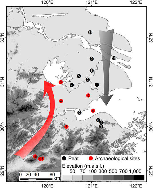
FIGURE 2. Mean centers of radiocarbon dates of archaeological sites and peat per 1,000 years. Numbers in the circles indicate the upper time limits per 1,000 years of mean centers; e.g., 11 suggests 12,000–11,000 cal yr BP. Arrows indicate the shift directions of the mean centers. DEM data are provided by the Geospatial Data Cloud site, Computer Network Information Center, and Chinese Academy of Sciences (http://www.gscloud.cn).
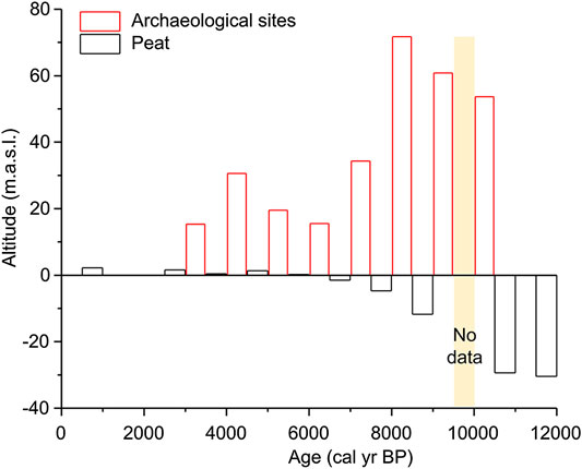
FIGURE 3. Average altitude per 1,000 years of radiocarbon dates of the archaeological sites and peat.
Summed Probability Distributions of the Archaeological Radiocarbon Dates
Figure 4 shows the SPD curves of archaeological radiocarbon dates for the lower Yangtze region. The overall curve gradually increased from ca. 11,000 to ca. 5,000 cal yr BP, although there were small fluctuations in this period. During ca. 5,000–4,700 cal yr BP, the curve sharply increased initially followed by a sharp decrease. After ca. 4,700 cal yr BP, the curve tended to decrease. For the SPD of the archaeological radiocarbon dates, the peak periods of the subregions in the lower Yangtze region differed. The peak periods of the Jinqu Basin, Ningshao Plain, and Taihu region were ca. 9,200–8,300 cal yr BP, ca. 7,900–5,000 cal yr BP, and ca. 5,000–4,400 cal yr BP, respectively. The core areas of the Neolithic population shifted from the Jinqu Basin to the Ningshao Plain and then to the Taihu region at ca. 8,300–8,000 cal yr BP and 5,200–4,900 cal yr BP, respectively.
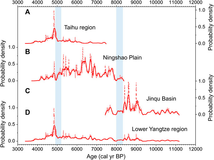
FIGURE 4. Summed probability distributions (SPD) of the archaeological radiocarbon dates in the lower Yangtze region. (A) Taihu region. (B) Ningshao Plain. (C) Jinqu Basin. (D) Lower Yangtze region. Dotted curves show the SPD results and solid lines show the 200-point-smoothing of the SPD results. Blue bands show the shift periods of core areas of population.
Summed Probability Distributions of the Radiocarbon Dates of Peat
The SPD curves of peat through the Holocene in the lower Yangtze region were constructed, and these showed a fluctuating trend. The more developed periods of peat formation were ca. 9,100–8,000 cal yr BP, ca. 7,600–6,200 cal yr BP, ca. 5,700–5,300 cal yr BP, ca. 5,000–4,400 cal yr BP, ca. 3,500–2,700 cal yr BP, and ca. 1,700–800 cal yr BP (Figure 5).
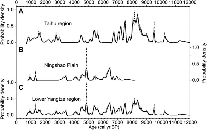
FIGURE 5. Summed probability distributions (SPD) of radiocarbon dates of peat in the lower Yangtze region. (A) Taihu region. (B) Ningshao Plain. (C) Lower Yangtze region. Dotted curves show the SPD results and solid lines show the 200-point-smoothing of the SPD results.
Discussion
What Do the Summed Probability Distributions of Peat Mean in This Study
Peat is one of several wetland products (Chai, 1990; Lang et al., 1999; Mitsch and Gosselink, 2015). Necessary conditions for peat formation include the presence of organic matter and a relatively long-term and calm waterlogged environment. This means that the high SPD of peat in the lower Yangtze region indicates a widespread wetland environment characterized by abundant plant growth and relatively stable and excess water table. This type of wetland environment can provide abundant resources and suitable conditions for farming around this area. Whereas the mean centers are different from SPD, as mean centers identify the geographic centers of archaeological or peat dates distribution, calculated as the average x and y geographical coordinates of dates per 1,000 years (Scott and Janikas, 2010).
Impacts of Wetland Environment on Demographic Development
As indicated by previous studies, the resources and environmental characteristics of wetland environment made it attractive for ancient people (Chen et al., 2008; Zong et al., 2011; Beach et al., 2019). In this study, the mean altitude of archaeological dates sharply decreased after 8,000 cal yr BP (Figure 3), and the SPD of archaeological dates also revealed that the first transition of core areas of demographic distribution, from the hilly regions to the coastal areas, occurred at ca. 8,300–8,000 cal yr BP, when peat was widespread in the coastal areas (Figure 6). This suggested that the wetland environment might be responsible for this transition. Meanwhile, the 8.2 ka event might be another reason for the transition. Previous investigations reported that the 8.2 ka cold event led to the migration or collapse of human population (González-Sampériz et al., 2009; Wicks and Mithen, 2014). In the lower Yangtze region, paleobotany evidences indicated the cold and dry conditions around 8.2 ka (Song et al., 2017; Zuo et al., 2020). Thus, the reduced resources caused by vegetation changes in the hilly regions and the attractive coastal marshes might have caused the transition of the core areas of population in the lower Yangtze region.

FIGURE 6. Comparison between the SPD of radiocarbon dates of archaeological sites and peat. (A) SPD of archaeological radiocarbon dates in the Taihu region. (B) SPD of archaeological radiocarbon dates in the Ningshao Plain. (C) SPD of archaeological radiocarbon dates in the Jinqu Basin. (D) SPD of radiocarbon dates of peat in the lower Yangtze region. (E) SPD of archaeological radiocarbon dates in the lower Yangtze region. All these are 200-point-smoothing results. Orange bands show the peak periods of radiocarbon dates of archaeological sites and peat.
This type of wetland environment was not just attractive for ancient people, and it facilitated demographic development. Results of this study revealed that there were three periods of high SPD of peat dates during the middle Holocene, in the lower Yangtze region, ca. 7,600–6,200 cal yr BP, ca. 5,700–5,300 cal yr BP, and ca. 5,000–4,400 cal yr BP; these coincided with the flourishing of the Hemudu Culture and the Liangzhu Culture (Figure 6). Previous research in this area demonstrated that wetland food resources such as Typha, Euryale, and Trapa were a part of the diet of Kuahuqiao and Hemudu people (Zong et al., 2007; Fuller et al., 2009; Fuller and Qin, 2010; Zhang et al., 2020). The wetland environment was also suitable for rice farming (Chen et al., 2008; Zong et al., 2012; Ma et al., 2020). Hence, the formation and the reasonable resource utilization of the wetland environment might be the reason for the demographic development in the lower Yangtze region.
However, because of the long-term waterlogged conditions required for peat formation, such an area cannot be settled directly; this was reflected by the findings that the SPD peaks of human population and peat did not overlap in the same region and the mean centers of archaeological dates and peat dates finally kept apart in the lower Yangtze region (Figures 2, 7). Furthermore, when the peat layer overlapped with or was overlying on the cultural layer, that indicated the collapse of the culture in the sites area (Zheng et al., 2012; He et al., 2018). Meanwhile, the sudden appearance of the extensive waterlogged environment was indicative of the previous extreme climate events, such as floods and storms. Thus, the widespread waterlogged environment and previous extreme climate events reflected by the peak of SPD of radiocarbon dates of peat in the Ningshao Plain at ca. 6,600–6,200 cal yr BP might be the reason for the ubiquitous cultural interruption of Hemudu culture (He et al., 2018; Tang et al., 2019), and the high SPD of peat at ca. 5,000–4,400 cal yr BP may explain the decreasing population in this area (Figure 7).
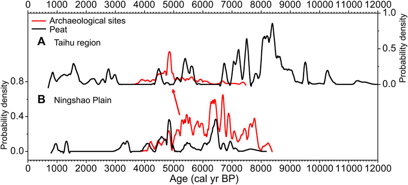
FIGURE 7. Comparison between the SPD of radiocarbon dates of archaeological sites and peat in the Ningshao Plain and the Taihu region. (A) Taihu region. (B) Ningshao Plain. All these are 200-point-smoothing results. Red arrow indicates the shift of demographic centers.
Possible Environmental Backgrounds for Peat Formation in the Lower Yangtze Region
The reasons for peat formation were complex and included climatological, geological, and hydrological factors (Chai, 1990; Lang et al., 1999; Mitsch and Gosselink, 2015). In the lower Yangtze region, peat was used to reconstruct Holocene sea-level changes or floods (Zhao et al., 1979; Zhang et al., 2004; Zong, 2004; Zhang et al., 2005; Zhan and Wang, 2014). The altitudes of peat nearly fit the curve of sea-level changes in this study (Figure 8A). Additionally, through the comparison with El Niño-Southern Oscillation (ENSO) frequency (Moy et al., 2002), the results showed that the widening of the spread of peat coincided with the high frequency of ENSO events during the period of relatively stable sea-level (Figures 8B,C). A previous study by Jiang et al. (2006) indicated that high frequency of ENSO events was correlated with abundant precipitation in the middle and lower Yangtze region. The rising sea-level or the abundant precipitation contributed to saltwater intrusion or an increase in the relative water level in the low-lying plain, which raised the groundwater level and led to inundation (Alizadeh et al., 2015; Becker et al., 2020). Thus, the abundance of water might promote peat formation in the lower Yangtze region.
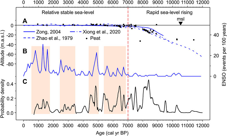
FIGURE 8. Environment backgrounds of peat formation. (A) Sea-level curves of east China (Zhao et al., 1979; Zong, 2004; Xiong et al., 2020) and altitude of peat in this study. (B) El Niño-Southern Oscillation (ENSO) events per 100 years (Moy et al., 2002). (C) SPD of radiocarbon dates of peat in the lower Yangtze region (200-point-smoothing result).
Higher precipitation caused by frequent ENSO events or rising sea-level were viewed as disasters for prehistoric coastal people. However, studies indicated ancient people could also benefit from El Niño floodwaters by converting them into productive water for agriculture (Caramanica et al., 2020). In addition, the increased sediment supply during the period of high sea-level resulted in the acceleration of coastal progradation and formation of livable flatlands (Ma et al., 2020). As in the lower Yangtze region, ENSO events or sea-level rising might facilitate human societies by promoting the formation of wetlands. As the data in this study are limited, more studies are required for a better understanding of coastal wetland environment and its relationship with human societies and climate changes.
Conclusion
This study was the first attempt to use peat as an indicator of the wetland environment in the lower Yangtze region, with the reconstruction of demographic development via archaeological radiocarbon dates. The data were used to investigate the impacts of wetland environment on Neolithic demographic evolution. The demographic centers of the lower Yangtze region transitioned from the hilly regions to the coastal plain at ca. 8,300–8,000 cal yr BP, which was likely influenced by the 8.2 ka event and the attraction of the wetland environment. Peat formation coincided with the development of the population during the middle Holocene in the lower Yangtze region, indicating that the wetland environment facilitated Neolithic demographic development. However, due to the long-term waterlogged environment requirement for peat formation, the region with widespread peat formation could not be settled directly. The widespread peat in the Ningshao Plain during ca. 5,000–4,400 cal yr BP might be the reason for the transition of the core area of the population.
Data Availability Statement
The original contributions presented in the study are included in the article/Supplementary Material; further inquiries can be directed to the corresponding author.
Author Contributions
KS and JZ designed research. KH and KS collected data. KS analyzed data. KS, JZ, CW, and HL wrote the article. All authors read and approved the final manuscript.
Funding
This study was supported by the National Natural Science Foundation of China (NSFC), grant no. 41830322, Strategic Priority Research Program of Chinese Academy of Sciences, grant no. XDB26000000, National Key R&D Program of China, grant no. 2020YFC1521605, Shandong University Multidisciplinary Research and Innovation Team of Young Scholars, grant no. 2020QNQT018, and Youth Innovation Promotion Association of the Chinese Academy of Sciences.
Conflict of Interest
The authors declare that the research was conducted in the absence of any commercial or financial relationships that could be construed as a potential conflict of interest.
Acknowledgments
We sincerely thank Xiujia Huan and Kangkang Li for their advice. We would like to thank Editage (www.editage.cn) for English language editing.
Supplementary Material
The Supplementary Material for this article can be found online at: https://www.frontiersin.org/articles/10.3389/feart.2021.635640/full#supplementary-material
References
Alizadeh, K., Cohen, M., and Behling, H. (2015). Origin and dynamics of the northern South American coastal savanna belt during the Holocene – the role of climate, sea-level, fire and humans. Quat. Sci. Rev. 122, 51–62. doi:10.1016/j.quascirev.2015.05.009
Beach, T., Luzzadder-Beach, S., Krause, S., Guderjan, T., Valdez, F., Fernandez-Diaz, J. C., et al. (2019). Ancient Maya wetland fields revealed under tropical forest canopy from laser scanning and multiproxy evidence. Proc. Natl. Acad. Sci. U. S. A. 116, 21469–21477. doi:10.1073/pnas.1910553116
Becker, M., Papa, F., Karpytchev, M., Delebecque, C., Krien, Y., Khan, J. U., et al. (2020). Water level changes, subsidence, and sea level rise in the Ganges-Brahmaputra-Meghna delta. Proc. Natl. Acad. Sci. U. S. A. 117, 1867–1876. doi:10.1073/pnas.1912921117
Bevan, A., Colledge, S., Fuller, D., Fyfe, R., Shennan, S., and Stevens, C. (2017). Holocene fluctuations in human population demonstrate repeated links to food production and climate. Proc. Natl. Acad. Sci. U. S. A. 114, E10524–E10531. doi:10.1073/pnas.1709190114
Brain, M. J., Kemp, A. C., Hawkes, A. D., Engelhart, S. E., Vane, C. H., Cahill, N., et al. (2017). Exploring mechanisms of compaction in salt-marsh sediments using Common Era relative sea-level reconstructions. Quat. Sci. Rev. 167, 96–111. doi:10.1016/j.quascirev.2017.04.027
Caramanica, A., Huaman Mesia, L., Morales, C. R., Huckleberry, G., Castillo B, L. J., and Quilter, J. (2020). El Niño resilience farming on the north coast of Peru. Proc. Natl. Acad. Sci. U. S. A. 117, 24127–24137. doi:10.1073/pnas.2006519117
Center for the Study of Chinese Archaeology, Peking University, Zhejiang Province Institute of Cultural Relics Archaeology (2011). Integrated studies on the natural remains from Tianluoshan Site. Beijing: Cultural Relics Press. [in Chinese].
Chen, Z., Zong, Y., Wang, Z., Wang, H., and Chen, J. (2008). Migration patterns of neolithic settlements on the abandoned yellow and Yangtze river deltas of China. Quat. Res. 70, 301–314. doi:10.1016/j.yqres.2008.03.011
Cultural Relics and Archaeology Institute of Zhejiang Province, Huzhou Museum (2014). Qiangshanyang A report on the third and fourth excavations of the site. Beijing, China: Cultural Relics Press. [in Chinese].
Dommain, R., Couwenberg, J., and Joosten, H. (2011). Development and carbon sequestration of tropical peat domes in south-east Asia: links to post-glacial sea-level changes and Holocene climate variability. Quat. Sci. Rev. 30, 999–1010. doi:10.1016/j.quascirev.2011.01.018
Dong, G., Li, R., Lu, M., Zhang, D., and James, N. (2020). Evolution of human–environmental interactions in China from the late paleolithic to the bronze age. Prog. Phys. Geogr. 44, 233–250. doi:10.1177/0309133319876802
Fuller, D. Q., Qin, L., Zheng, Y., Zhao, Z., Chen, X., Hosoya, L. A., et al. (2009). The domestication process and domestication rate in rice: spikelet bases from the lower Yangtze. Science 323, 1607–1610. doi:10.1126/science.1166605
Fuller, D. Q., and Qin, L. (2010). Declining oaks, increasing artistry, and cultivating rice: the environmental and social context of the emergence of farming in the Lower Yangtze Region. Environ. Archaeol. 15, 139–159. doi:10.1179/146141010X12640787648531
Goldberg, A., Mychajliw, A. M., and Hadly, E. A. (2016). Post-invasion demography of prehistoric humans in South America. Nature 532, 232–235. doi:10.1038/nature17176a
González-Sampériz, P., Utrilla, P., Mazo, C., Valero-Garcés, B., Sopena, M. C., Morellón, M., et al. (2009). Patterns of human occupation during the early Holocene in the Central Ebro Basin (NE Spain) in response to the 8.2 ka climatic event. Quat. Res. 71, 121–132. doi:10.1016/j.yqres.2008.10.006
Guo, L., Xiong, S., Ding, Z., Jin, G., Wu, J., and Ye, W. (2018). Role of the mid-Holocene environmental transition in the decline of late Neolithic cultures in the deserts of NE China. Quat. Sci. Rev. 190, 98–113. doi:10.1016/j.quascirev.2018.04.017
He, K., Lu, H., Zheng, Y., Zhang, J., Xu, D., Huan, X., et al. (2018). Middle-Holocene sea-level fluctuations interrupted the developing Hemudu culture in the lower Yangtze River, China. Quat. Sci. Rev. 188, 90–103. doi:10.1016/j.quascirev.2018.03.034
Hijma, M. P., and Cohen, K. M. (2019). Holocene sea-level database for the Rhine-Meuse Delta, The Netherlands: implications for the pre-8.2 ka sea-level jump. Quat. Sci. Rev. 214, 68–86. doi:10.1016/j.quascirev.2019.05.001
Innes, J. B., Zong, Y., Wang, Z., and Chen, Z. (2014). Climatic and palaeoecological changes during the mid- to Late Holocene transition in eastern China: high-resolution pollen and non-pollen palynomorph analysis at Pingwang, Yangtze coastal lowlands. Quat. Sci. Rev. 99, 164–175. doi:10.1016/j.quascirev.2014.06.013
Institute of Archaeology, China Academy of Social Sciences (2010). Chinese Archaeology Neolithic. Beijing, China: China Social Sciences Press. [in Chinese].
Jiang, L., and Liu, L. (2006). New evidence for the origins of sedentism and rice domestication in the Lower Yangzi River, China. Antiquity 80, 355–361. doi:10.1017/S0003598X00093674
Jiang, T., Zhang, Q., Zhu, D., and Wu, Y. (2006). Yangtze floods and droughts (China) and teleconnections with ENSO activities (1470–2003). Quat. Int. 144, 29–37. doi:10.1016/j.quaint.2005.05.010
Lang, H., Zhao, K., and Chen, K. (1999). Wetland vegetation in China. Beijing, China: Science Press. [in Chinese].
Li, C., Li, Y., and Burr, G. S. (2014). Testing the accuracy of 14C age data from pollen concentrates in the Yangtze Delta, China. Radiocarbon 56, 181–187. doi:10.2458/56.16920
Liu, B., Wang, N., Chen, M., Wu, X., Mo, D., Liu, J., et al. (2017). Earliest hydraulic enterprise in China, 5,100 years ago. Proc. Natl. Acad. Sci. U. S. A. 114, 13637–13642. doi:10.1073/pnas.1710516114
Long, T., Hunt, C. O., and Taylor, D. (2016). Radiocarbon anomalies suggest late onset of agricultural intensification in the catchment of the southern part of the Yangtze Delta, China. CATENA 147, 586–594. doi:10.1016/j.catena.2016.08.017
Ma, T., Rolett, B. V., Zheng, Z., and Zong, Y. (2020). Holocene coastal evolution preceded the expansion of paddy field rice farming. Proc. Natl. Acad. Sci. U. S. A. 117, 24138–24143. doi:10.1073/pnas.1919217117
Michczyńska, D. J., Michczyński, A., and Pazdur, A. (2007). Frequency distribution of radiocarbon dates as a tool for reconstructing environmental changes. Radiocarbon 49, 799–806. doi:10.1017/S0033822200042673
Michczyńska, D. J., and Pazdur, A. (2004). Shape analysis of cumulative probability density function of radiocarbon dates set in the study of climate change in the Late Glacial and Holocene. Radiocarbon 46, 733–744. doi:10.1017/S0033822200035773
Moy, C. M., Seltzer, G. O., Rodbell, D. T., and Anderson, D. M. (2002). Variability of El niño/southern oscillation activity at millennial timescales during the Holocene epoch. Nature 420, 162–165. doi:10.1038/nature01194
Patalano, R., Wang, Z., Leng, Q., Liu, W., Zheng, Y., Sun, G., et al. (2015). Hydrological changes facilitated early rice farming in the lower Yangtze River Valley in China: a molecular isotope analysis. Geology 43, 639–642. doi:10.1130/G36783.1
Reimer, P. J., Austin, W. E. N., Bard, E., Bayliss, A., Blackwell, P. G., Bronk Ramsey, C., et al. (2020). The IntCal20 Northern Hemisphere radiocarbon age calibration curve (0–55 cal kBP). Radiocarbon 62, 725–727. doi:10.1017/RDC.2020.41
Scott, L. M., and Janikas, M. V. (2010). “Spatial statistics in ArcGIS,” in Handbook of applied spatial analysis. Editors M. Fischer, and A. Getis (Berlin, Germany: Springer). doi:10.1007/978-3-642-03647-7_2
Shanghai Museum, (2014). Proceedings on the excavation at guang fu lin. Shanghai, China: Shanghai Classics Publishing House. [in Chinese].
Shennan, S., Downey, S. S., Timpson, A., Edinborough, K., Colledge, S., Kerig, T., et al. (2013). Regional population collapse followed initial agriculture booms in mid-Holocene Europe. Nat. Commun. 4, 2486. doi:10.1038/ncomms3486
Song, B., Li, Z., Lu, H., Mao, L., Saito, Y., Yi, S., et al. (2017). Pollen record of the centennial climate changes during 9–7 cal ka BP in the Changjiang (Yangtze) River Delta plain, China. Quat. Res. 87, 275–287. doi:10.1017/qua.2017.1
Stanley, D. J., and Chen, Z. (2000). Radiocarbon dates in China's Holocene Yangtze delta: record of sediment storage and reworking, not timing of deposition. J. Coast. Res. 16, 1126–1132.
Stuiver, M., and Reimer, P. J. (1993). Extended 14C data base and revised Calib 3.0 14C age calibration program. Radiocarbon 35, 215–230. doi:10.1017/S0033822200013904
Su, B., and Yin, W. (1981). Regional distribution, evolutionary lines and types of archaeological cultures. Cult. Relics 5, 10–17. [in Chinese].
Tang, L., Lv, Y., Nian, X., Lei, S., and Wang, Z. (2019). Middle Holocene seawater intrusion and human’s rapid response in the Yaojiang-Ningbo coastal plain, China. Quat. Sci. 39, 1116–1132. [in Chinese]. doi:10.11928/j.issn.1001-7410.2019.05.05
Törnqvist, T. E., Bick, S. J., González, J. L., van der Borg, K., and de Jong, A. F. M. (2004). Tracking the sea-level signature of the 8.2 ka cooling event: new constraints from the Mississippi Delta. Geophys. Res. Lett. 31, L23309. doi:10.1029/2004GL021429
Wang, C., Lu, H., Zhang, J., Gu, Z., and He, K. (2014a). Prehistoric demographic fluctuations in China inferred from radiocarbon data and their linkage with climate change over the past 50,000 years. Quat. Sci. Rev. 98, 45–59. doi:10.1016/j.quascirev.2014.05.015
Wang, H., Chen, J., Zhang, X., and Chen, F. (2014b). Palaeosol development in the Chinese Loess Plateau as an indicator of the strength of the East Asian summer monsoon: evidence for a mid-Holocene maximum. Quat. Int. 334–335, 155–164. doi:10.1016/j.quaint.2014.03.013
Wicks, K., and Mithen, S. (2014). The impact of the abrupt 8.2 ka cold event on the Mesolithic population of western Scotland: a Bayesian chronological analysis using “activity events” as a population proxy. J. Archaeol. Sci. 45, 240–269. doi:10.1016/j.jas.2014.02.003
Xiong, H., Zong, Y., Li, T., Long, T., Huang, G., and Fu, S. (2020). Coastal GIA processes revealed by the early to middle Holocene sea-level history of east China. Quat. Sci. Rev. 233, 106249. doi:10.1016/j.quascirev.2020.106249
Xu, D., Lu, H., Chu, G., Liu, L., Shen, C., Li, F., et al. (2019). Synchronous 500-year oscillations of monsoon climate and human activity in Northeast Asia. Nat. Commun. 10, 4105. doi:10.1038/s41467-019-12138-0
Xu, Y., Lin, Z., and Jiang, L. (2020). The correlation between landscape characteristics in Qu River and the site selection of Shangshan Culture. Adv. Geosci. 10, 778–791. [in Chinese]. doi:10.12677/ag.2020.108078
Xu, Y., Lin, Z., and Jiang, L. (2016). The relationship between the distribution of archaeological sites of Shangshan Culture and environment. Cult. Relics South. China 3, 131–138. [in Chinese].
Yan, W. (1987). The unification and diversity of prehistorical culture of China. Cult. Relics 3, 38–50. [in Chinese].
Yang, Q., Zheng, H., Taylor, D. M., Hu, Z., Zhou, B., Ma, C., et al. (2020). Catastrophic tidal bores associated with sea level rise: a lesson from the collapse of Kuahuqiao Neolithic Culture, East Coastal China. Earth Space Sci. Open Arch. doi:10.1002/essoar.10504129.1
Zhan, Q., and Wang, Z. (2014). Mid-Holocene sea-level of northern Yangtze River delta reconstructed by salt marsh peat. J. Palaeogeogr. Chin. ed. 16, 548–556. [in Chinese].
Zhang, Q., Jiang, T., Shi, Y., Lorenz, K., Liu, C., and Martin, M. (2004). Paleo-environmental changes in the Yangtze Delta during past 8000 years. J. Geogr. Sci. 14, 105–112. doi:10.1007/BF02873097
Zhang, Q., Zhu, C., Liu, C., and Jiang, T. (2005). Environmental change and its impacts on human settlement in the Yangtze Delta, P.R. China. CATENA 60, 267–277. doi:10.1016/j.catena.2004.12.001
Zhang, Y., van Geel, B., Gosling, W. D., Sun, G., Qin, L., and Wu, X. (2020). Typha as a wetland food resource: evidence from the Tianluoshan site, Lower Yangtze Region, China. Veg. Hist. Archaeobot. 29, 51–60. doi:10.1007/s00334-019-00735-4
Zhao, X., Geng, X., and Zhang, J. (1979). Sea level changes of the eastern China during the past 20000 years. Acta Oceanologia. Sinica. 1, 269–281. [in Chinese].
Zhejiang Provincial Institute of Cultural Relics and Archaeology (2019). A comprehensive study of Liangzhu ancient city. Beijing, China: Cultural Relics Press. [in Chinese].
Zheng, Y., Sun, G., and Chen, X. (2012). Response of rice cultivation to fluctuating sea level during the Mid-Holocene. Chin. Sci. Bull. 57, 370–378. doi:10.1007/s11434-011-4786-3
Zong, Y., Chen, Z., Innes, J. B., Chen, C., Wang, Z., and Wang, H. (2007). Fire and flood management of coastal swamp enabled first rice paddy cultivation in east China. Nature 449, 459–462. doi:10.1038/nature06135
Zong, Y., Innes, J. B., Wang, Z., and Chen, Z. (2012). Environmental change and Neolithic settlement movement in the lower Yangtze wetlands of China. Holocene 22, 659–673. doi:10.1177/0959683611414933
Zong, Y., Innes, J. B., Wang, Z., and Chen, Z. (2011). Mid-Holocene coastal hydrology and salinity changes in the east Taihu area of the lower Yangtze wetlands, China. Quat. Res. 76, 69–82. doi:10.1016/j.yqres.2011.03.005
Zong, Y. (2004). Mid-Holocene sea-level highstand along the southeast coast of China. Quat. Int. 117, 55–67. doi:10.1016/S1040-6182(03)00116-2
Zuo, X., Lu, H., Jiang, L., Zhang, J., Yang, X., Huan, X., et al. (2017). Dating rice remains through phytolith carbon-14 study reveals domestication at the beginning of the Holocene. Proc. Natl. Acad. Sci. U. S. A. 114, 6486–6491. doi:10.1073/pnas.1704304114
Keywords: peat, archaeological radiocarbon dates, summed probability distributions, wetlands, demographic center shift, Holocene
Citation: Shao K, Zhang J, He K, Wang C and Lu H (2021) Impacts of the Wetland Environment on Demographic Development During the Neolithic in the Lower Yangtze Region—Based on Peat and Archaeological Dates. Front. Earth Sci. 9:635640. doi: 10.3389/feart.2021.635640
Received: 30 November 2020; Accepted: 22 January 2021;
Published: 09 March 2021.
Edited by:
Guanghui Dong, Lanzhou University, ChinaReviewed by:
Kangyou Huang, Sun Yat-Sen University, ChinaCheng Zhao, Nanjing Institute of Geography and Limnology (CAS), China
Copyright © 2021 Shao, Zhang, He, Wang and Lu. This is an open-access article distributed under the terms of the Creative Commons Attribution License (CC BY). The use, distribution or reproduction in other forums is permitted, provided the original author(s) and the copyright owner(s) are credited and that the original publication in this journal is cited, in accordance with accepted academic practice. No use, distribution or reproduction is permitted which does not comply with these terms.
*Correspondence: Jianping Zhang, anB6aGFuZ0BtYWlsLmlnZ2Nhcy5hYy5jbg==