Abstract
Studying seismicity in a volcanic environment provides important information on the state of activity of volcanoes. The seismicity of the Neapolitan volcanoes, Campi Flegrei, Vesuvius, and Ischia, shows distinctive characteristics for each volcano, covering a wide range of patterns and types. In this study we relocated some significant volcano-tectonic earthquake swarms that occurred in Campi Flegrei and Vesuvius. Moreover, we compared the earthquake occurrence evolution, the magnitude and the seismic energy release of the three volcanoes. Also, we considered the results of seismic analysis in the light of geochemical and ground deformation data that contribute to defining the state of activity of volcanoes. In Campi Flegrei, which is experiencing a long term unrest, we identified a seismogenic structure at shallow depth in Pisciarelli zone that has been activated repeatedly. The increasing seismicity accompanies an escalation of the hydrothermal activity and a ground uplift phase. At Vesuvius a very shallow seismicity is recorded, which in recent years has shown an increase in terms of the number of events per year. Earthquakes are usually located right beneath the crater axis. They are concentrated in a volume affected by the hydrothermal system. Finally, Ischia generally shows a low level of seismicity, however, in Casamicciola area events with a moderate magnitude can occur and these are potentially capable of causing severe damage to the town and population, due to their small hypocentral depth (typically < 2.5 km). After the seismic crisis of August 21, 2017 (mainshock magnitude M = 4), the seismicity returned to a low level in terms of occurrence rate and magnitude of earthquakes. The seismicity of these three different volcanic areas shows some common aspects that highlight a relevant role of hydrothermal processes in the seismogenesis of volcanic areas. However, while the main swarms in Campi Flegrei and most of the Vesuvian earthquakes are distributed along conduit-like structures, the seismicity of Ischia is mainly located along faults. Furthermore, the temporal evolution of seismicity in Neapolitan volcanic area suggests a concomitant increase in the occurrence of earthquakes both in Campi Flegrei and Vesuvius in recent years.
Introduction
The Neapolitan volcanic area (southern Italy) includes three active volcanic complexes: Campi Flegrei, Vesuvius, and Ischia (Figure 1). These volcanoes show different structural characteristics and behaviors. However, they have a common geodynamic origin and together they form the Campanian Volcanic Province (e.g. Conticelli et al., 2010; Peccerillo, 2020).
FIGURE 1
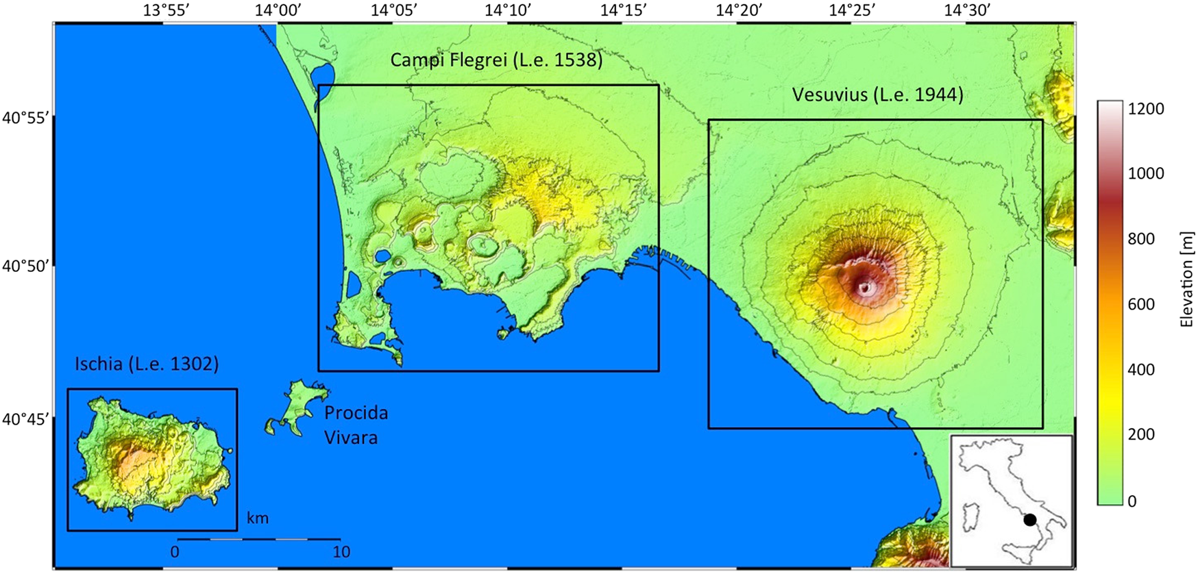
Map of the Neapolitan volcanoes (Vesuvius, Campi Flegrei and Ischia). The figure shows the year of last eruption (L.e.) of the three volcanoes. The color scale represents elevation. The difference in height between the level lines is 150 m. See Acocella and Funiciello (2006) for structural details and Passaro et al. (2016) for bathymetry.
The volcanism in the Neapolitan district started about 1.5 Ma with a widespread effusive activity characterized by calc-alkaline andesitic and basaltic compositions as revealed by geothermal boreholes drilled NW of the Campi Flegrei caldera (Barbieri et al., 1979). Subsequently, from about 300 ka, new volcanic activity, fed by alkaline magmas (Scarpati et al., 2013), has generated the still active Campi Flegrei, Ischia and Vesuvius volcanic complexes.
The substructure of these volcanic areas has been investigated through several geophysical surveys (e.g. De Natale et al., 2006a; De Natale et al., 2006b and reference therein). Geophysical data, constrained by deep boreholes, showed that the deep structure of this volcanic area comprises 1.5–3 km of interbedded lavas and volcanoclastic, marine, and fluvial sedimentary rocks of Pleistocene age (Rosi and Sbrana, 1987; Brocchini et al., 2001; Di Renzo et al., 2007). These sequences overlay the Mesozoic carbonate sequences extending from two to four to roughly 8–11 km depth (Cubellis et al., 1991, Cubellis et al., 1995; Cubellis et al., 2001; Berrino et al., 1998, Berrino et al., 2008; Improta and Corciulo, 2006) on the Ercinian crystalline basement. The Moho discontinuity occurs at about 30 and 25 km depth beneath Vesuvius and Campi Flegrei and Ischia Island respectively (e.g., De Natale et al., 2006b; Nunziata, 2010). A low-velocity layer, interpreted as the top of a magmatic body, was detected by seismic tomography at 7–8 km depth beneath the Campi Flegrei caldera and Vesuvius volcano (Auger et al., 2001; Zollo et al., 2008). This evidence, that is consistent with the similarity in petrological features of the products from these volcanoes, suggests that a widely distributed magma source may be active beneath the entire Neapolitan volcanic district (Pappalardo and Mastrolorenzo, 2012).
The Neapolitan volcanic area developed on the Tyrrhenian edge of the Campanian plain that is characterized by extensive tectonic activity, which, since the Quaternary, has led to the formation of the Campanian graben (Bruno et al., 2003; Acocella and Funiciello, 2006; Torrente and Milia, 2013; Fedi et al., 2018). Extensive hydrothermal circulation is associated with these systems where several overlapping geothermal reservoirs interbedded within the volcanic succession have been identified (Aiuppa et al., 2006).
The Neapolitan volcanoes are among the longest inhabited volcanic areas, and therefore have a long historical record of natural events; moreover the high population density of this area implies a tremendous social impact of the volcanic risk. For these reasons a vast scientific literature has developed on these volcanoes, focusing mainly on Campi Flegrei and Ischia, which have shown greater variations in the last few years. A complete treatment of this literature is beyond the scope of this work, which focuses on comparing some characteristics of the seismicity of the three volcanoes, highlighting the common aspects.
Basically, the Neapolitan volcanoes cover a wide range of volcanic seismicity patterns and types (Chouet and Matoza, 2013) and well represent the behavior of different types of closed conduit active volcanoes. For this reason, they are generally studied individually. However, in recent decades some clues highlighted by seismic tomography (Auger et al., 2001) and petrographic studies of Vesuvius and Campi Flegrei (Pappalardo and Mastrolorenzo, 2012; Esposito et al., 2020a; Esposito et al., 2020b) suggested possible links between these volcanoes. Therefore, in the following we characterize the status of the three Neapolitan volcanoes, through their seismic activity and also using geodetic (GPS) and geochemical observations, and we investigate their temporal evolution in recent years to highlight differences and similarities among them.
Neapolitan Volcanoes
Vesuvius
Somma-Vesuvio is a stratovolcano consisting of an older cone (Somma) with a polygenetic caldera where the Vesuvio (or Vesuvius) cone has been built up during the last 2000 years. The Somma activity started about 33 ka BP with prevailing emission of lava flows and scoriae. In the last 22 ka, the volcanic activity become highly explosive producing tens of 4/5 Volcanic Explosivity Index (VEI) eruptions, including the last plinian eruption of Pompeii in 79 AD (Sigurdsson et al., 1985), and, most recently, the sub-plinian 472 (Sulpizio et al., 2005) and 1,631 (Braccini, 1632) eruptions. After the 1,631 eruption, Vesuvius remained in open conduit condition and was characterized by almost continuous intra-crater activity, until the last eruption, which occurred in 1944. On March 18, 1944, the eruption began with a lava flow that partially destroyed the towns of Massa di Somma and San Sebastiano al Vesuvio and was followed by an explosive phase, a few days later (March 22). An eruptive column of approximately 6 km height developed causing abundant volcanic ash-fall that reached large distance from the vent (Pappalardo et al., 2014; Cubellis et al., 2013, Cubellis et al., 2016). After this eruption, Vesuvius changed from open to closed conduit conditions and, nowadays, it persists in a quiescent state. The activity of Vesuvius from 1,631 onwards is well documented by contemporary chronicles (Baratta, 1897; Alfano and Friedlaender, 1929; Santacroce, 1987 and reference therein; Marturano and Scaramella, 1998; Guidoboni, 2008), allowing us to establish the precursory phenomena, which generally preceded Vesuvian eruptions in the last four centuries. Among the precursors, earthquakes were the most common ones (Cubellis et al., 2007; Cubellis and Marturano, 2013 and reference therein; Marturano, 2006; Scandone and Giacomelli, 2008). Particularly, the seismicity of Vesuvius before and during the 1944 eruption was recorded by a seismic station (Giudicepietro et al., 2010) installed in the historic site of the Osservatorio Vesuviano (OVO site in Figure 2) and described by Imbò. (1954) and more recently re-evaluated by Pappalardo et al. (2014). Seismic data from that period include Long Period (LP) events, explosion and lava fountain signals. After 1944 the seismicity disappeared for some years. In 1964 a series of landslides occurred in the crater of Vesuvius, accompanied by a partial collapse of the bottom of the crater (Imbò, 1964; Imbò et al., 1964). After this event, the seismicity resumed in 1966.
FIGURE 2
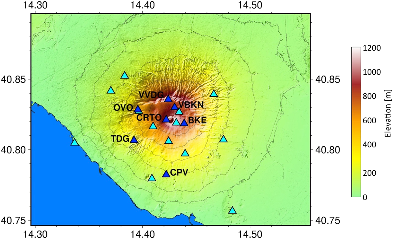
Map of Vesuvius seismic network. The triangles are the seismic stations. The blue ones with labels are the stations used to locate a long-period transient (LP) recorded on November 16, 2020. The label is also shown for OVO station, which is installed in the historical building of the Osservatorio Vesuviano and is the reference for the seismic catalog of Vesuvius.
Currently, Vesuvius shows moderate seismicity with some hundreds of earthquakes per year, with magnitudes typically between −1.0 and 2.0, mainly located in the axial zone of the crater. This zone extends to a depth of about 4 km (Cubellis and Marturano, 2002; Giudicepietro et al., 2010; Cubellis and Marturano, 2013; D’Auria et al., 2013; D’Auria et al., 2014; D’Auria and Massa, 2015; Ricco et al., 2021). The geochemical interpretation of the fumarolic compositions reveals the presence of a hydrothermal system, with temperatures as high as 400–450°C, possibly hosted between 1.5 and 4 km depth within the still hot volcanic conduits of the recent Vesuvius eruptions (Chiodini et al., 2001b).
Campi Flegrei
Campi Flegrei produced at least six large-scale explosive eruptions in the last 250 ka (e.g., Albert et al., 2019; De Vivo et al., 2001). The largest of these events are the two ignimbrite eruptions of the Campanian Ignimbrite (CI, 300 km3 DRE, 40 ka, Gebauer et al., 2014) and the Neapolitan Yellow Tuff (40 km3, 14.9 ka, following Deino et al., 2004) that caused the collapse of the 12 km-wide Campi Flegrei caldera. In the last 15 ka this nested collapse structure was the site of a monogenetic volcanic activity producing about 70 eruptions with variable VEI, spanning from 0 to 5. The last Monte Nuovo (Figure 3) eruption (VEI 2) occurred in 1538 AD after a period of ca 3,000 years of quiescence and was preceded by intense and long-term precursory phenomena (Di Vito et al., 2016) such as ground deformation and seismic activity. Seismicity continued even after the eruptive event at least until the end of the 16th century (Guidoboni and Ciuccarelli, 2011). After the 16th century the area was generally under subsidence (Niccolini, 1829, Niccolini, 1839, Niccolini, 1846). The subsidence was interrupted in 1945–1953 when a first bradyseism crisis occurred, with an uplift of about 0.5 m, followed by the two main episodes of 1969–1972 (about 1.7 m uplift) and 1982–1984 (about 1.8 m uplift), which led to a total ground uplift of about 3.5 m in the central sector of the caldera (Del Gaudio et al., 2010). After 1985 subsidence reappeared and continued until 2000 leading to a ground lowering of about 85 cm. During the bradyseism crisis of 1982–84, the ground uplift was accompanied by a remarkable seismicity (more than 16,000 earthquakes, most of them with magnitude < 3, max Md = 4.0). After 1985, the seismicity in Campi Flegrei almost disappeared and resumed in July 2000 with a swarm of LP events (Saccorotti et al., 2001; D’Auria et al., 2011). From 2005 a gradual resumption of uplift occurred in Campi Flegrei with a significant increase of its rate at the end of 2012 when the Italian Department of Civil Protection raised the alert level from the base (green) to yellow (attention).
FIGURE 3
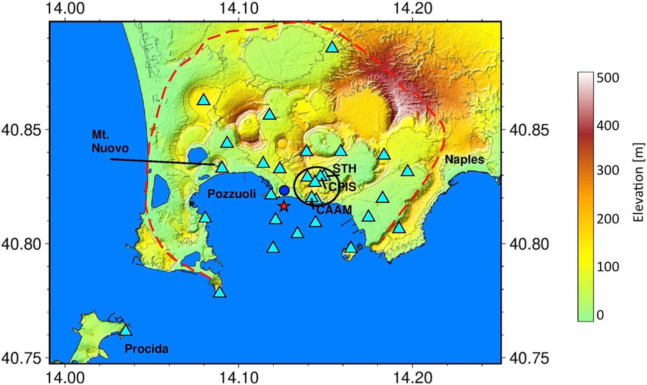
Map of Campi Flegrei. The cyan triangles indicate the seismic network stations. STH (catalog reference station) and CPIS (used for calculating the fumarolic tremor amplitude) stations are indicated on the map. The blue circle indicates the RITE GPS station. The red star marks the area of maximum uplift (Iannaccone et al., 2018). The red dashed line indicates the edge of the caldera. The black ellipse encloses the hydrothermal area of Solfatara-Pisciarelli. Monte Nuovo is the cone formed in the last eruption (1,538).
Campi Flegrei caldera is also characterized by an intense hydrothermal activity highlighted by the emission of large amounts of deeply derived gases from soil diffuse degassing and from strong fumarolic vents at Solfatara-Pisciarelli (Chiodini et al., 2001a; Cubellis et al., 2002; D’Auria et al., 2011; Chiodini et al., 2012; Amoruso et al., 2014; Cardellini et al., 2017; Tamburello et al., 2019). Seismic activity is currently increasing and it is mainly concentrated in the same hydrothermal sites of Solfatara-Pisciarelli, with hypocentral depths rarely exceeding 2 km and M < = 3.3 (Chiodini et al., 2021; Giudicepietro et al., 2021; Tramelli et al., 2021).
Ischia
Ischia is the emerged part of an active volcanic field, which rises more than 1,000 m above the seafloor (Orsi et al., 1999; Bruno et al., 2002), along the margin of an E-W trending scarp that borders to the south the Phlegraean volcanic district. At Ischia, volcanism began before 150 ka BP and has continued intermittently, with quiescent periods lasting centuries to millennia, until the last eruption in AD 1302 (Vezzoli, 1988; Orsi et al., 1996; de Vita et al., 2010). The volcanic and deformation history is dominated by the caldera-forming Monte Epomeo Green Tuff (MEGT) eruption at about 55 ka (Vezzoli, 1988), during a period of activity that generated the most voluminous and devastating eruptions of the island (Brown et al., 2008, and references therein). The MEGT caldera floor was later affected by resurgence that generated uplift of about 900 m, probably over the past 33 ka (the age of the oldest deformed rocks). Orsi et al. (1991) explain this remarkable resurgence through a simple-shearing mechanism, and tilting of differentially displaced blocks; the most uplifted one is Monte Epomeo, whereas other authors (e.g. Acocella and Funiciello, 1999), on the basis of more recent data, interpreted it as due to a trap-door like mechanism. Mount Epomeo plays an important role in the seismic activity of Ischia. This structure was subject to a remarkable uplift in the period between 33 ka and about 5 ka and was interpreted as a resurgent block (Vezzoli, 1988). It is not easy to date the end of the resurgence of the Mt. Epomeo block (e.g. Carlino et al., 2006; Carlino, 2012; Trasatti et al., 2019; Cubellis et al., 2020). Currently a subsidence of about 1 cm/year occurs in the northern sector of the Island, as recorded from GPS, optical leveling and DInSAR measurements (see eg: De Martino et al., 2011; Manzo et al., 2006, De Novellis et al., 2018; Trasatti et al., 2019). The post-MEGT volcanic history has been subdivided into three periods of activity based on structural and volcanological evidence, as well as geochemical and isotopic variations of the magmas erupted through time (Civetta et al., 1991). Even if, since the last eruption occurred in AD 1302, no evidence of renewal of uplift has been recorded in concurrence with more recent minor mass movements, the magmatic system of Ischia has to be considered still active. The presence of a hydrothermal system characterized by energetic circulation underneath Ischia is demonstrated by the numerous surface manifestations, including fumaroles, thermal waters, steaming grounds and mud pools. Since accurate geodetic measurements have been made (early 20th century), central-southern portion of the island has subsided. Generally, Ischia has a low level of seismicity, characterized by few events per year with a magnitude typically between -1 and 2.5 (see the catalog included in the supplementary Datasheet S1), which is concentrated in the Casamicciola area (D’Auria et al., 2018). However, as known, in this area, events with a relatively greater magnitude can occur (Carlino et al., 2006; Cubellis et al., 2004, 2020; De Novellis et al., 2018; D’Auria et al., 2018; Selva et al., 2021), which are potentially capable of causing severe damage to the town and population. This happened in 1883, when an earthquake with intensity XI MCS degree and magnitude of about 5 destroyed the town of Casamicciola, causing approximately 2,300 victims, and in August 2017, when an M4.0 earthquake caused severe damage to the town and two victims. The earthquake of August 2017 is the last seismic event with a significant impact on the island.
Data
Seismic Data
The Osservatorio Vesuviano seismic network (INGV-OV) currently consists of 34 broadband digital stations and 18 short-period seismic stations (5 with only vertical component and 13 triaxial), which continuously transmit signals to the Monitoring Center. Some of them are co-located in the same site for redundancy and continuity in the catalogs. The network is designed for monitoring the active Neapolitan volcanic areas, Vesuvius (Figure 2), Campi Flegrei (Figure 3), Ischia (Figure 4) and provides information on seismicity at a regional scale in collaboration with the national seismic network managed by Osservatorio Nazionale Terremoti (INGV-ONT). In the period 2010–2012 the seismic network was densified on the three volcanoes. Moreover, three OBS have been installed in Campi Flegrei in recent years (Iannaccone et al., 2018). The current geometry of the network of the Neapolitan volcanoes, in low seismic noise condition, allows to reliably locate seismic events with M < 0, in Vesuvius, Campi Flegrei and Ischia.
FIGURE 4

Map of Ischia island with the seismic stations (cyan triangles) and the two GPS, stations MEPO and SERR (blue circles) that were considered in this work. OC9 is the reference station for the seismic catalog of Ischia.
The data are collected at Osservatorio Vesuviano in Naples through intermediate data centers (e.g. in Ercolano). The analogue station data are acquired at Posillipo data center and then transmitted to the Osservatorio Vesuviano headquarter via TCP/IP protocol using a dedicated WiFi link. Here, an Earthworm-based system (Johnson et al., 1995; Johnson 2020) is devoted to the automatic detection and location of seismic events. This system provides a good quality location in a few tens of seconds after the detection of an earthquake.
In this article we consider the seismic catalogs of Vesuvius, Campi Flegrei and Ischia, that are routinely updated by the Osservatorio Vesuviano seismic laboratory and are available on the website www.ov.ingv.it (last accessed on March 27, 2021). The catalogs are based on single-station detections, and exploit the long historical record provided by the most ancient stations such as OVO (Vesuvius), STH (Campi Flegrei) and OC9 (Ischia). These stations are located in sites close to the main seismogenic areas of each volcano, which are the summit cone for Vesuvius, Solfatara-Pisciarelli for Campi Flegrei and the area of Casamicciola Terme for Ischia. Numerous articles analyzed in detail the catalogs of Campi Flegrei (D'Auria et al., 2011; Giudicepietro et al., 2019; Tramelli et al., 2021), Vesuvius (Giudicepietro et al., 2010; D'Auria et al., 2013) and Ischia (D'Auria et al., 2018; Selva et al., 2021). We refer to these works for an in-depth analysis of the seismological statistics of these three volcanoes. However, here we present the estimate of the completeness thresholds and the b-values of the entire catalogs and other basic elaborations, such as the monthly and annual distribution of all the detected earthquakes of the three areas, in order to have elements to compare the seismicity in the three volcanoes. The catalogs used in this work are also included in the supplementary Datasheet S1.
The traditional seismic catalog of Vesuvius is based on the earthquakes recorded at OVO station (in the historical building of Osservatorio Vesuviano in Ercolano). It begins in 1972 and includes 11,610 earthquakes, until December 2020. The catalog is based on a single station and is generated using the duration magnitude (Md), suitable for local earthquakes. The duration of the earthquakes is determined by the analysts of the seismic laboratory through visual analysis of seismograms. The same methodology is also used for the catalogs of the other volcanoes in the Neapolitan area, which are included in the supplementary Datasheet S1. Thanks to the BKE station (Bunker Est), which was installed on the top of Mount Vesuvius in 1999, an additional catalog of the events recorded near the crater is available. The BKE catalog (1999–2020) currently includes 18,663 events, many of which have magnitude < 1 and can only be recorded at the summit of Mount Vesuvius.
The revised catalog of Campi Flegrei covers the period from January 2007 to December 2020. It contains 4,473 earthquakes recorded at the STH reference station, installed near the Solfatara-Pisciarelli area. When the background seismic noise is particularly low, this station can detect earthquakes with magnitude < = −0.2. However, smaller earthquakes are often not locatable. Actually, only 1,437 of the 4,473 earthquakes in the catalog of the Campi Flegrei are located.
Finally, the seismic catalog of Ischia includes 147 earthquakes recorded in the 1999–2020 interval at OC9 station installed in the historical Osservatorio Geofisico della Gran Sentinella in Casamicciola Terme (Ischia), founded in 1885 by the geophysicist Giulio Grablovitz. Most of these earthquakes are located in the Casamicciola area.
We consider a period of 14 years, from January 2007 to November 2020, to compare the time evolution of the seismicity of the three volcanoes. During the selected period, the permanent seismic network of Osservatorio Vesuviano recorded a total of 16,804 events, of which 12,208 in Vesuvius, 4,473 in Campi Flegrei and 123 in Ischia.
In addition to the catalog data, we use a selection of the locations of the Campi Flegrei earthquakes, the best quality ones, e g., A and B quality with location errors typically in the range of 200–300 m (locations and related errors are reported in the supplementary Datasheet S1) from the INGV Osservatorio Vesuviano database. We use the hypocentral parameters of the INGV database also as initial locations to relocate the earthquakes of the April 26, 2020 swarm, the largest one that occurred in Campi Flegrei since 1984 in terms of energy released. Moreover, we calculated ex novo the locations of the Vesuvius earthquakes from 2015 to 2020 and in 1999, to compare the most relevant swarm, which occurred in October 1999, with that occurred in November-December 2018 (see. “Methods”). For Ischia we used the locations recently published in D’Auria et al. (2018) and Selva et al. (2021).
GPS Data
We use the data of few selected stations of the permanent GPS network dedicated to monitoring the Neapolitan volcanoes (De Martino et al., 2011; Tammaro et al., 2013; De Martino et al., 2014; Devoti et al., 2018; De Martino et al., 2020). In particular, to highlight the vertical ground displacements in the three Neapolitan volcanoes, we used the daily average of the vertical component from the RITE station (Figure 3) in Campi Flegrei (between January 2010 and November 2020); BKNO (Figure 2) at Vesuvius (between June 2010 and November 2020) and SERR (January 2004–November 2020) and MEPO (February 2017 - November 2020) in Ischia (Figure 4).
Geochemical Data
The fumaroles located in the bottom of the Vesuvius crater are sampled systematically in the frame of the surveillance of the volcano. Here we consider 68 samples (collected from 2010 to November 2020) for which we estimate the equilibrium temperatures within the gas system H2O-H2-CO2-CH4-CO using the method described in Chiodini et al. (2001a) and Caliro et al. (2011). The estimated temperatures, in the range from 379 to 441°C, are regularly reported in the Osservatorio Vesuviano surveillance reports (see, e.g., Figure. 4.3 in www.ov.ingv.it/ov/bollettini-mensili-campania/Bollettino_Mensile_Vesuvio_2020_12.pdf).
Methods
In this study we used hypoDD (Waldhauser and Ellsworth, 2000) software to relocate the events of the seismic swarm occurred in Campi Flegrei on April 26, 2020, which was the largest swarm since the volcanic crisis of 1982–85 and included the largest Phlegraean earthquake (Md 3.3) recorded since 1984. We relocated this important swarm to compare it with two other significant swarms that occurred on October 7, 2015 and December 6, 2019, respectively, which occurred in the same area and showed particular characteristics studied in Giudicepietro et al. (2021). As initial locations we used those determined by the Osservatorio Vesuviano seismic laboratory, with the hypo71 (Lee and Lahr, 1975) program that are available online at www.ov.ingv.it (last accessed March 27, 2021). We did not use cross-correlation derived relative picks for the relocation but we exploited the manual picking of the P and S phases carried out by the seismic laboratory analysts of the Osservatorio Vesuviano (INGV). We preprocessed the phase picking data using the ph2dt software (a utility available in the hypoDD package) to obtain travel time differences for pairs of earthquakes at common stations. Then we applied hypoDD using the conjugate gradients method (LSQR, Paige and Saunders, 1982). We reported the relocation output file in the supplementary Datasheet S1. This file contains the hypocentral parameters including the location errors, however the error values are not meaningful in case the relocations are computed using LSQR method (Paige and Saunders, 1982). The mean horizontal and vertical errors on the initial locations are about 300 m and 200 m respectively.
We located the earthquakes that occurred on Vesuvius between January 2015 and November 2020 using hypo71, adopting a velocity model derived from the integration of different velocity models of the Neapolitan volcanic area elaborated in D'Auria et al. (2008). To overcome the problems due to the topography of the volcano and the close spacing of the seismic network stations we considered 1,000 m altitude as the reference level on the volcanic edifice and we appropriately configured the station delays in the locator input file. In this way we were able to locate the small shallow earthquakes that occur inside the volcanic edifice above the sea level. We also located the earthquakes of a swarm that occurred in October 1999, which include the largest event recorded on Vesuvius so far (M = 3.6). The mean horizontal and vertical errors on the locations are about 350 m and 420 m respectively (see supplementary Datasheet S1).
Furthermore, we located a Long Period (LP) event, which occurred at Vesuvius on November 16, 2020. LP events are very rare on Vesuvius. One of them took place on July 20, 2003 and was studied by Cusano et al. (2013). This type of events is related to the presence of fluids in the seismogenic volume and can be associated with magmatic or hydrothermal fluids (Chouet and Matoza, 2013). In order to locate the LP transient recorded on November 16, 2020 we exploited the onset of the event, which is recognizable on the vertical component of 7 different stations. We estimated the time delay through cross correlation analysis of the vertical component of the signals recorded at different stations. We computed the cross correlation using the Obspy toolbox for seismology utilities (Krischer et al., 2015). So we retrieved the arrival times of the LP transient at 7 different stations and we located it with the same method illustrated above.
In order to statistically characterize the seismicity of the three areas and to be able to compare them, we estimated the magnitude of completeness (Mc) and the b-values for the entire catalogs of the single reference stations for the three volcanoes, STH (Campi Flegrei), BKE and OVO (Vesuvius), OC9 (Ischia). We adopted the method of Aki. (1965), which gives the b-value as a function of Mc. First, we varied the Mc and calculated the residual between the data with M> = Mc and the Gutenberg-Richter magnitude-frequency distribution. Then, we chose the Mc associated with the smaller residual (see supplementary Datasheet S1). So, we obtained the following results: OVO catalog b-value 1.7 Mc 1.7, BKE catalog b-value 1.5 Mc 1.6, STH catalog b-value 0.95 Mc 0.0, OC9 catalog b-value 0.6 Mc 0.4. We also compared our results with those reported in recent literature (D'Auria et al., 2013, D'Auria et al., 2018; Giudicepietro et al., 2019; Tramelli et al., 2021) and we found consistent values. Concerning the estimates of the b-value reported in Selva et al. (2021) for Ischia, where the authors found 1.11, the difference in the b-value is mostly due to the different adopted magnitude (Mw instead of Md) and the use of a new integrated catalog.
To highlight the changes taking place in Campi Flegrei, we updated the time series of Pisciarelli's fumarolic tremor and the “background seismicity” (Chiodini et al., 2017b), two seismological parameters that have significant correlations with geochemical variations in the Phlegraean area.
The amplitude of the fumarolic tremor is measured on the vertical component signal of the CPIS station, installed in 2010 in Pisciarelli, 8 m away from the main fumarole of Campi Flegrei caldera. The signal is filtered in the characteristic frequency band generated by the fumarole and the nearby mud pool (5–15 Hz). The amplitude is calculated as the average of the absolute value (RSAM as defined in Endo and Murray, 1991) over 30-min windows. The details are described in Chiodini et al. (2017a), Giudicepietro et al. (2019) and Giudicepietro et al. (2021). The “background seismicity” of the Campi Flegrei caldera was defined in Chiodini et al., 2017b by extracting the seismic clusters (or earthquake swarms) from the catalog and considering them as a single episode of seismicity like a single event. This parameter shows a good agreement with ground deformations and with the temporal evolution of geochemical parameters (Chiodini et al., 2017b).
For the seismic data of Ischia, where earthquakes are less frequent than at Vesuvius and Campi Flegrei, we have not carried out new analyses and have reported already available locations (D’Auria et al., 2018; Selva et al., 2021).
The results of the original analyses we performed for this article, i.e. the relocations of the April 26, 2020 swarm at Campi Flegrei, the locations of the earthquakes recorded on Vesuvius between January 2015 and November 2020 and in 1999, the location of the LP transient recorded on Vesuvius on November 16, 2020, are included in the supplementary Datasheet S1 together with the seismic catalogs which are also available on the Osservatorio Vesuviano (INGV) website (www.ingv.it, last accessed March 30, 2021), where they are periodically updated.
Results
In this section we present the results of the data analysis in the context of the knowledge on the eruptive history, historical seismicity and dynamics of the three Neapolitan volcanoes. For Campi Flegrei and Vesuvius we show results from new analyses, whereas for Ischia we summarize results from previous works.
Campi Flegrei Seismicity
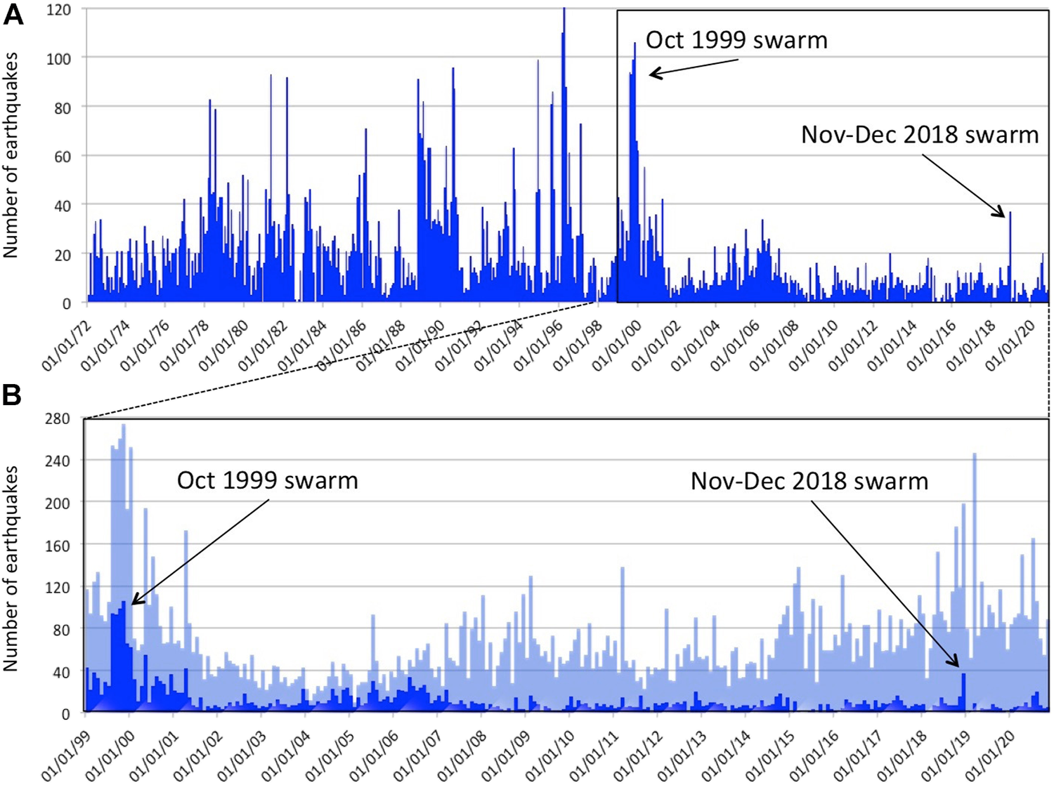
Over the past 2 decades a gradual increase in seismicity has occurred in Campi Flegrei (Tramelli et al., 2021). Until 2014, earthquakes were rare and occurred in swarms of numerous events with low magnitudes, such as on January 23, 2009 (173 events, Mmax = 0.0), March 30, 2010 (141 events, Mmax = 1.2) and September 7, 2012 (188 events, Mmax = 1.7) (Figure 5A). After 2014, the seismicity occurrence changed: the events became more frequent over time (Figures 5A,C), the seismic energy release and the “background seismicity” (Chiodini et al., 2017b) increased (Figure 5C), the number of events in a single swarm decreased even if earthquakes with greater magnitude characterized the swarms. The histogram in Figure 5B shows the magnitude distribution (Mmean = −0.2). The magnitude-frequency distribution can be consistent with a Gutenberg-Richter distribution with the b-value = 0.95 (see Method section). The red curve in Figure 5A shows the monthly maximum magnitude. The fumarolic tremor that is a robust indicator of the activity of the Pisciarelli-Solfatara hydrothermal system (Chiodini et al., 2017a; Giudicepietro et al., 2019; Giudicepietro et al., 2021) showed a continuous increase and reached its maximum amplitude in September 2020 (Figure 5D).
FIGURE 5
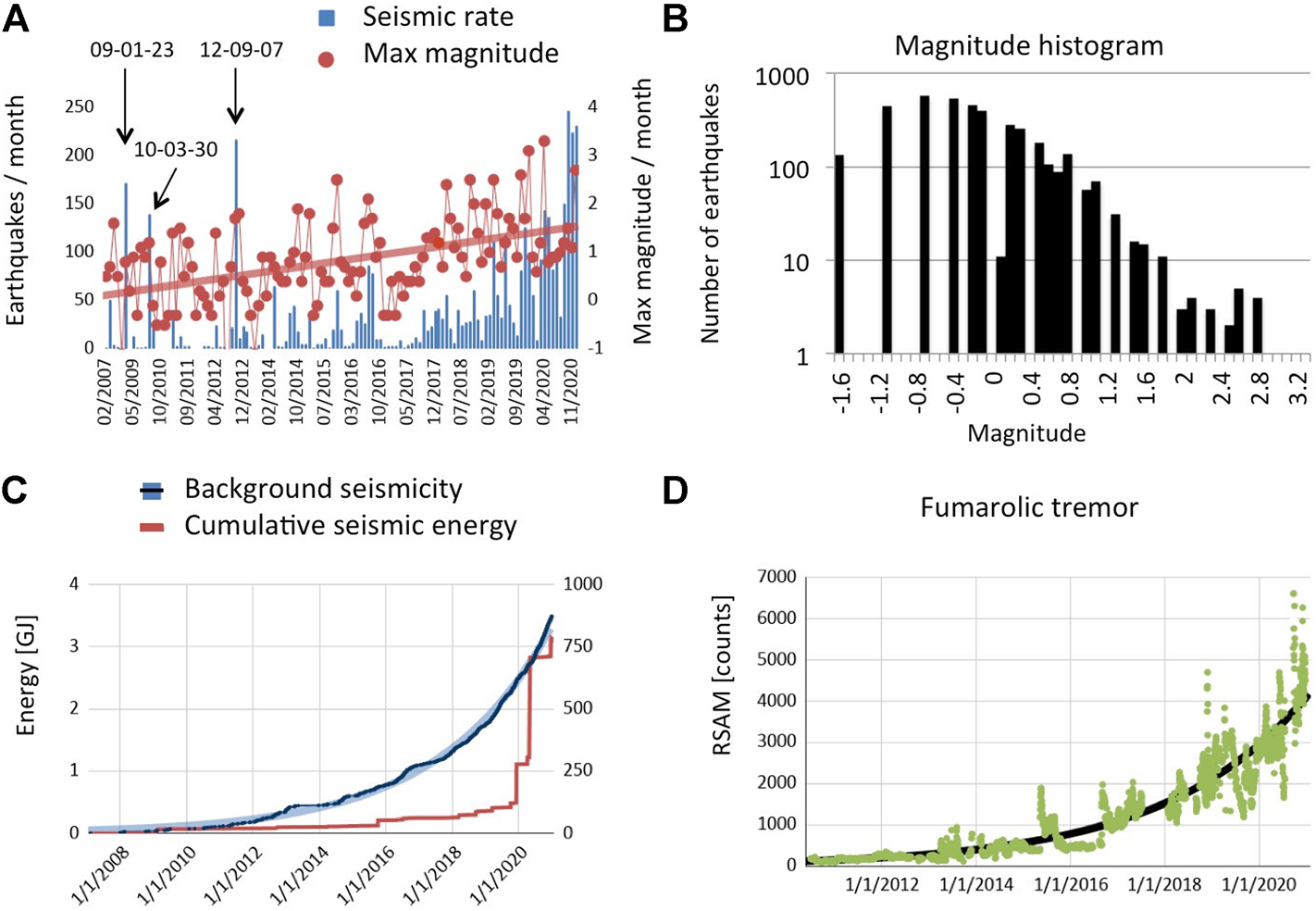
Seismicity of Campi Flegrei. (A) Histogram of earthquakes per month detected by the STH seismic station since January 2007 (seismic catalog of Campi Flegrei, in supplementary Datasheet S1). The red curve with the circle markers shows the maximum magnitude of each month. (B) Histogram of earthquake magnitudes in the Campi Flegrei catalog (Log scale on vertical axis). (C) The red curve represents the cumulative seismic energy in GJ. The black curve is the ‘background seismicity’ defined in Chiodini et al. (2017b) (right axis). The light blue curve represents an exponential trend line. It can be seen that the exponential trend closely approximates the temporal evolution of the ‘background seismicity’. (D) In green the amplitude of the fumarolic tremor since January 2010 recorded at CPIS station that was installed on January 2010. The black curve represents an exponential trend line. It can be seen that also in this case the exponential trend closely approximates the temporal evolution of the fumarolic tremor indicating an acceleration of the ongoing process.
A relationship between seismicity and injection of fluids into the hydrothermal system was evidenced for the two swarms of October 7, 2015 and December 6, 2019 in Giudicepietro et al. (2021). This relationship was highlighted by a sudden increase in the amplitude of the fumarolic tremor at Pisciarelli (Giudicepietro et al., 2021), recognized as a proxy of the activity of the hydrothermal system at Campi Flegrei (Chiodini et al., 2016).
In recent decades, after the 1982–1984 crisis, the most energetic earthquake swarm occurred on April 26, 2020. Here, we analyzed that swarm comparing it with the two swarms occurred on October 7, 2015 and December 6, 2019, studied in Giudicepietro et al. (2021), which are located in the same seismogenic volume. We compared the waveform of the April 26, 2020 major earthquake (Md 3.3, the largest one since 1984) with two of the largest events belonging to the swarms of October 2015 and December 2019, which form a distinct family of earthquakes (Giudicepietro et al., 2021). We calculated the cross-correlation of a 1s-sliding window of the April 26, 2020 (Md 3.3) earthquake onset (CAAM station vertical component) with the two selected events of the swarms of October 7, 2015 and December 6, 2019. We found a correlation of 0.9 with the onset of both events. This suggests that the April 26, 2020 (Md 3.3) earthquake belongs to the same family as the largest events of the swarms that occur in Pisciarelli area. Figure 6 shows the spectrogram and waveform of this earthquake and the comparison of its onset with the two events of the October 7, 2015 and December 6, 2019 swarms. The spectrogram (Figure 6A) is typical of VT earthquakes with an impulsive onset characterized by a wide frequency range up to 30 Hz. The comparison of the onsets (Figure 6B) confirms that the main event of the April 26, 2020 swarm shares with the major earthquakes occurred in recent years similar waveform characteristics. Furthermore, we calculated the focal mechanism of the April 26, 2020 Md 3.3 earthquake using FPFIT software (Reasenberg and Oppenheimer, 1985). It shows a solution that can be associated with normal-type mechanisms with an oblique component (Figure 7D) and it is similar to those found in Giudicepietro et al. (2021) for the major earthquakes of the October 2015 and December 2019 swarms. This further similarity with the major earthquakes of the swarms located in the Solfatara–Pisciarelli area shows that the same seismogenic structure has been reactivated several times in recent years.
FIGURE 6
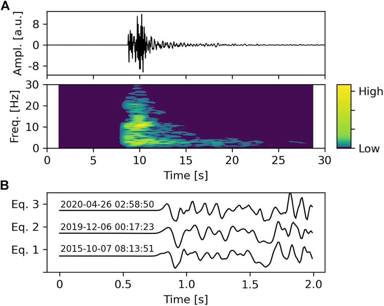
(A) Seismogram and spectrogram of the Md 3.3 earthquake recorded during the April 26, 2020 swarm. (B) The onset of the earthquake (Eq. 3) is compared with one of the major events of the swarm occurred on October 7, 2015 (Eq. 1 Md = 2.3) and the strongest event of the December 6, 2019 swarm (Eq. 2 Md = 3.1). CAAM station (see Figure 3) vertical components are shown.
FIGURE 7

Locations (A and B quality) of the earthquakes recorded in Campi Flegrei between January 2000 and November 2020. The hypocenters are indicated with a black dot (70% transparency). The green circles mark the earthquakes of the October 7, 2015 swarm. The red circles highlight the earthquakes of the December 6, 2019 swarm. The blue circles indicate the earthquake locations of the April 26, 2020 swarm (included in supplementary Datasheet S1). Only for events that belong to these three swarms the diameter of the circle is proportional to the magnitude. The location of the April 26, 2020 Md 3.3 earthquake is shown in cyan (lat: 40.831319N; lon: 14.147029E; depth: 2,618 m b.s.l.).
We also performed relative locations of the April 26, 2020 swarm (blue circles in Figure 7) using the hypoDD software (Waldhauser and Ellsworth, 2000). The relocation confirmed that the April 26, 2020 swarm occurred along the same conduit-like path already identified in Giudicepietro et al. (2021) for the October 7, 2015 and December 6, 2019 swarms (Figure 7).
Typically the relatively high magnitude events (Md max = 3.3) of the swarms occurred in Solfatara–Pisciarelli area, and in particular for the three main swarms considered in this work (Oct 2015, Dec 2019 and Apr 2020), are deeper than those of the ordinary Campi Flegrei seismicity (Chiodini et al., 2021). In the December 6, 2019 swarm a clear migration of the hypocenters toward the surface was also observed (Giudicepietro et al., 2021).
The double-difference locations of the swarms of October 7, 2015 and December 6, 2019 are published as supplementary Datasheet S1 in Giudicepietro et al. (2021). The double-difference locations of the events of the swarm that occurred on April 26, 2020 are included in the supplementary Datasheet S1 of this article. The locations of the earthquakes from 2000 to 2020 are available online on the Osservatorio Vesuviano (INGV) website (www.ov.ingv.it), as well as the seismic catalogs.
More recently, four earthquakes with magnitude Md > 2 were recorded in December 2020 (see supplementary Datasheet S1, Table 1). Two of these earthquakes belong to a swarm of 51 events, which occurred on December 19, 2020. In this case a sudden increase in the amplitude of the fumarolic tremor was observed during and after the swarm, confirming a mechanism linked to fluid injection in the hydrothermal system, similar to that observed for the swarms of the October 7, 2015 and December 6, 2019 (Giudicepietro et al., 2021). This shows that at least since 2015 a seismicity directly linked to injections of fluids in conduit-type paths has occurred in the Campi Flegrei, even if this is not the only source of earthquakes acting in the Phlegraean caldera.
TABLE 1
| Area | Last eruption | Station | Start time | Mc | b-value |
|---|---|---|---|---|---|
| Vesuvius | 1944 | OVO | 1972 | 1.7 | 1.7 |
| Vesuvius | “ | BKE | 1999 | 1.6 | 1.5 |
| Campi flegrei | 1538 AD | STH | 2007 | 0.0 | 0.95 |
| Ischia | 1302 AD | OC9 | 1999 | 0.4 | 0.6 |
Parameters of the frequency-magnitude distribution (b-value and Mc) of the three Neapolitan volcanic areas on the basis of single station catalogs.
Mt. Vesuvius Seismicity
Vesuvius is a very active volcano, with a predominantly explosive eruptive style (Arnò et al., 1987; Scandone and Giacomelli, 2008), that is located in a densely populated area (Figure 2). These factors make Vesuvius one of the highest risk volcanoes in the world.
After the 1944 eruption the seismicity of Vesuvius was very low, with few earthquakes per year, until 1966, when a local seismicity appeared, consisting of Volcano Tectonic events (VT), located in axis with the crater. The complete catalog from 1944 was reconstructed in Giudicepietro et al. (2010). Since 1972 the estimation of Vesuvian earthquake magnitude became systematic and allowed to create the seismic catalog (Figure 8A) based on the OVO station, installed at the Osservatorio Vesuviano historical site (Figure 2).
FIGURE 8
(A) Number of earthquakes per month detected by the OVO station from 1972 to December 31, 2020. (B) Comparison between the number of earthquakes per month detected by the OVO station (blue) and the BKE station (light blue) from 1999 to 2020 (November 30). The catalogs are included in the supplementary Datasheet S1.
The study of Vesuvius seismicity that occurred in the last 50 years and the densification of the seismic network in the summit area (Figure 2) made it possible to recognize two seismogenic volumes (Giudicepietro et al., 2010; D’Auria et al., 2013), one at a depth of about 4 km below the top of the edifice and the other one much shallower, where very small magnitude earthquakes are concentrated. The OVO station is mainly sensitive to earthquakes originated in the deep seismogenic zone whereas the BKE station can record even the shallow small earthquakes. Therefore, the comparison of OVO and BKE catalogs gives a picture of the two seismogenic volume temporal evolutions. Since 2008, earthquakes located in the deepest seismogenic zone decreased whereas shallow earthquakes were increasingly recorded (Figure 8B).
The implementation of a dense network in the summit area of Vesuvius between 2009 and 2011 made it possible to locate the very small magnitude (typically <0.5) earthquakes recorded at the top of Vesuvius, and so to discover the shallow seismogenic volume within the volcanic edifice (Figure 9A).
FIGURE 9
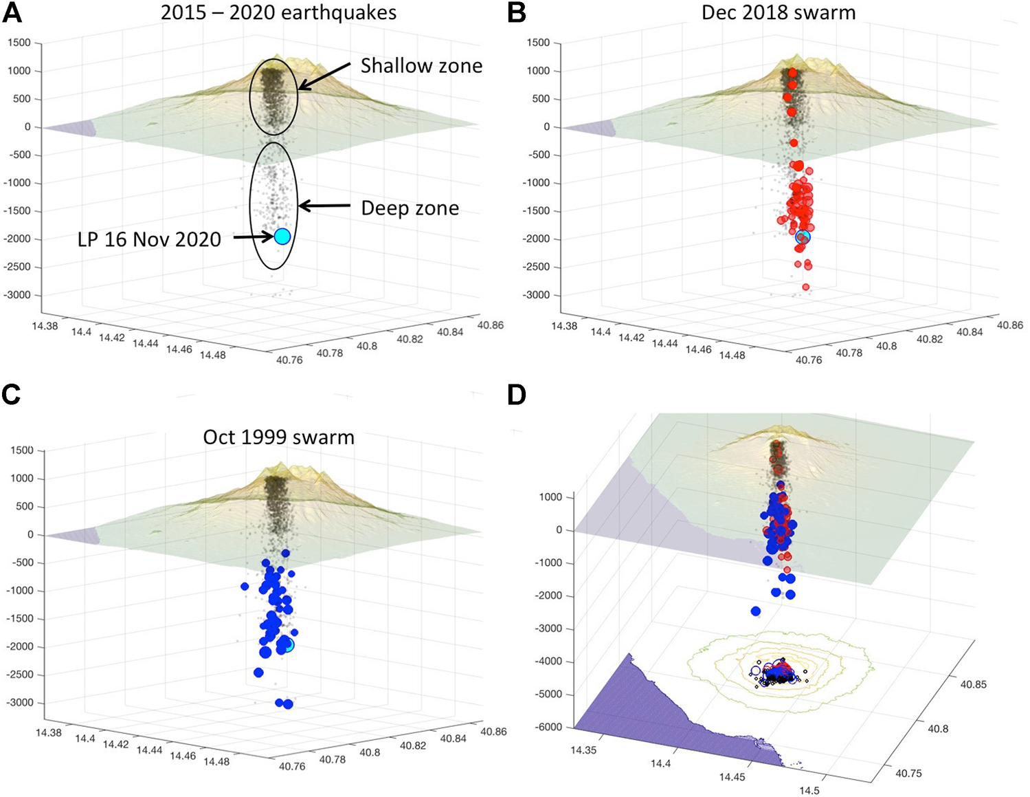
Earthquake locations at Vesuvius. (A) Location of earthquakes recorded on Vesuvius between January 2015 and November 2020. The events are indicated with a black dot (70% transparency). The cyan circle indicates the location of the LP transient recorded on November 16, 2020 at 5:58:55 (UTC). The two ellipses surround the “shallow” and “deep” seismogenic zones. (B) The red circles highlight the earthquakes of the swarm that occurred on November 30 December 1, 2018. (C) The blue circles indicate the earthquakes of the October 1999 swarm. The plot in panel (D) shows the comparison between the locations of the two swarms. In all plots the location of the LP transient is reported as a cyan circle. The sizes of the red and blue circles are proportional to the magnitudes of earthquakes of 2018 and 1999 swarms, respectively. The locations of the swarms and the LP transient are included in the supplementary Datasheet S1.
The most significant seismic crisis recorded at Vesuvius after the last eruption was on October 9, 1999 when a swarm of earthquakes with a relatively large magnitude occurred (Mmax = 3.6, the highest magnitude recorded so far at Vesuvius) (Figure 9C). In more recent times, a significant swarm occurred between November 29 and December 1, 2018 (Figure 9B). We compared the earthquake locations of the two swarms and we found that the events of both swarms are predominantly located in the deep seismogenic volume (Figure 9D). In addition, some events of the 2018 swarm were located in the shallower seismogenic zone. The lack of earthquakes in the shallow zone during the 1999 swarm (Figure 9C) is due to the seismic network configuration, which did not allow their location at that time. Actually, they were recorded by the BKE station, but it was not possible to locate them because the other stations did not register them.
Vesuvius seismic events are generally VT earthquakes (Figure 10A) with a magnitude that rarely exceeds 2 (Figure 10B). The magnitude-frequency distribution in Figure 10B is reasonably consistent with a Gutenberg-Richter distribution with the b-value = 1.5 (see Method section). Recently, the Vesuvius network recorded three seismic transients characterized by frequencies between 1 and 5 Hz that occurred between 5:58 and 6:00 (UTC) on November 16, 2020. These events, which can be classified as LP events based on their frequency content (Figure 10C), have emergent onset and duration of about 30 s each. However, the second has a clearer onset than the others so we located it by calculating the time delay of its onset at different stations using cross-correlation (Figure 10D). The location falls at the base of the deep seismogenic zone (cyan circle in Figure 9).
FIGURE 10
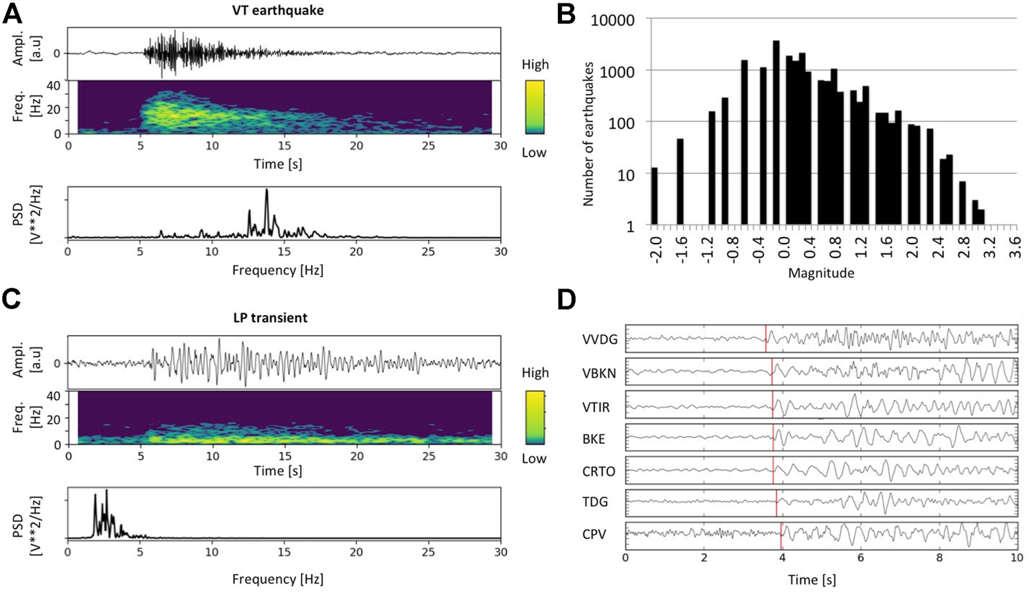
(A) Seismogram, spectrogram and spectrum of a typical Vesuvian VT earthquake recorded on November 29, 2020 at 5:16 am. (B) Distribution of the magnitude of the earthquakes recorded by the BKE station from 1999 to 2020 (BKE catalog; Log scale on vertical axis). (C) Seismogram, spectrogram and spectrum of the LP transient recorded on November 16, 2020 at 5:16 am. (D) Picking of the onset of the LP transient recorded on November 16, 2020 at 5:59 am. For the position of the seismic stations see Figure 1.
Ischia Seismicity
The seismicity of Ischia island has been instrumentally monitored since 1993. Before then we can still count on a historical catalog that goes up to the 8th century BC (Figure 11). This richness of historical information is to be attributed to the tourist attraction that the Ischia island has always exercised on people who have left written traces of what they have seen and heard during their holidays. Besides, since 1885 a seismic tank was working in the Geophysical Observatory of Casamicciola. This innovative instrument capable of measuring and recording the oscillations of the water contained in a tank was installed by the scientist Giulio Grablovitz (1846–1928) and maintained until 1923 (Luongo et al., 2012; Cubellis and Luongo, 2018; D’Auria et al., 2018). After a gap of 70 years, the first seismic station was installed in the same place of the seismic tank, Casamicciola Observatory (OC9 in Figure 4).
FIGURE 11
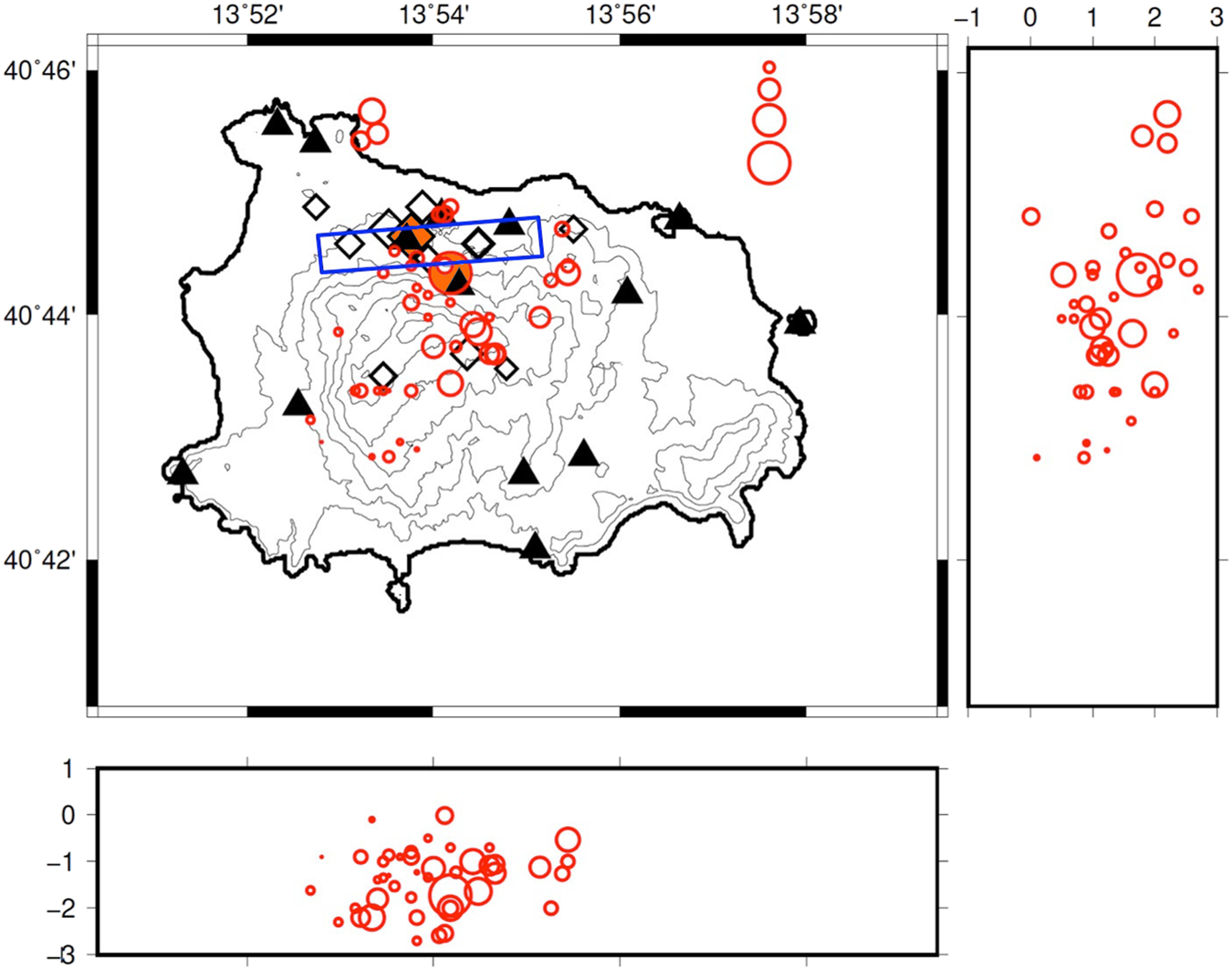
Map of Ischia island with the seismic stations (black triangles), the locations of earthquakes (red circles) recorded by the seismic network and the locations of historical earthquakes (black diamonds). Instrumental and hystorical catalogs are from Selva et al. (2021) and integrated with the earthquakes occurred in 2020. Diamond and circle filled in with orange indicate the July 28, 1883 and the August 21, 2017 earthquakes, respectively. For instrumental earthquakes, the size of the circle indicates the magnitude according to the scale shown at the top right of the figure. East-West and North-South sections are shown. The blue rectangle shows the fault trace of the August 21, 2017 earthquake retrieved in De Novellis et al. (2018). In the lower and lateral panels, the depths of the hypocenters are expressed in km.
The network was gradually improved until the four seismic sites equipped in 2011. After the 2017 M4.0 earthquake the network was improved reaching a total of 9 permanent and 5 mobile seismic stations. The complete (hystorical and instrumental) catalog has been recently revised by Selva et al. (2021). Their analysis evidenced that the Ischia seismicity is not stationary: the annual rate for earthquakes with a magnitude higher than 3.6 in the past (1750–1884) was six times larger than the current one (1885–2019) (Selva et al., 2021). These authors estimated a b-value higher than 1, as usual for volcanic areas, but the non-stationarity of the distribution of the seismic events makes the Gutenberg-Richter not the most appropriate relationship to describe the process. For the instrumental catalog the magnitude is estimated from the duration of the seismogram recorded at a seismic station located in the Casamicciola Observatory (D’Auria et al., 2018). The magnitude of the historical earthquakes has been converted from the intensity (Selva et al., 2021 and reference therein). As expected, the completeness magnitude highly decreases with time thanks to the improvement of the seismic network in the last decades.
The seismicity of Ischia is mainly associated with the faults of the northern boundary of the Mt. Epomeo block. Ischia indeed experienced one of the highest uplift measured at any volcano (more than 900 m in 35–55 ka) (Trasatti et al., 2019 and references therein), which produced a fault-bounded block (the Mt. Epomeo block) with topmost uplift to the NW and an overall tilt downward SE (Acocella and Funiciello, 1999). Currently the Epomeo block is subject to subsidence.
Several destructive earthquakes have been located in the northern part of the island with shallow hypocentre and estimated magnitude between 3.6 and 5.2: in 1,228 (700 casualties), 1796 (7 casualties), 1828 (30 casualties), 1881 (126 casualties), 1883 (2,333 casualties), and 2017 (2 casualties) (Cubellis and Luongo, 1998, 2018; D’Auria et al., 2018; De Novellis et al., 2018; Cubellis et al., 2020; Selva et al., 2021; Carlino et al., 2021).
Discussion
Using the catalogs based on single stations, edited and periodically updated by the seismic laboratory of the Osservatorio Vesuviano INGV, we obtained the b-values for the three areas shown in Table 1 (see Methods section).
As is known (Wiemer and Benoit, 1996), a positive anomaly of the b-value may indicate a higher pore pressure and a higher temperature of the earthquake source region. This is found in the analysis of the Vesuvius catalogs (OVO and BKE stations), whereas for Campi Flegrei the b-value does not show significant anomalies. On the contrary, the area of Casamicciola Terme in Ischia, where the OC9 station is located, shows a negative anomaly that could be consistent with the tectonic nature of the island’s seismicity. By applying the frequency-magnitude distribution analysis to a sliding window of a given number of earthquakes, Tramelli et al. (2021) showed that the b-value in Campi Flegrei increased over time and exceeded 1 in 2020. An increase over time of the b-value in Campi Flegrei was also highlighted by Giudicepietro et al. (2019). Similarly, Selva et al. (2021) found a b-value greater than 1 for Ischia using a new integrated seismic catalog. An in-depth discussion of this aspect is beyond the scope of this article. Taking into account the results of Tramelli et al. (2021), which were obtained by analyzing the same catalog used for this article, here we can highlight that the b-values calculated on the entire catalogs based on single stations suggest differences in the seismogenic conditions of Ischia with respect to Campi Flegrei and Vesuvius. Furthermore, the positive anomaly of the b-value at Vesuvius suggests a plumbing system characterized by high temperature and pore pressure. These physical conditions of the seismogenic volumes are consistent with the fact that Vesuvius erupted more recently than the other volcanoes (Table 1).
For describing the temporal evolution of the seismicity of the Neapolitan volcanoes in recent years, we consider the period January 2007–December 2020 (Figure 12 and Table 2), which is covered by the catalogs of all three volcanoes. In the selected period some changes in seismicity were observed in the area. Particularly Campi Flegrei, as already mentioned, have been subject to a gradual intensification of the seismicity which became remarkable in the last year (Figure 12A), when the number of earthquakes has, for the first time, exceeded those of Vesuvius (Figure 12D). The seismicity of Ischia was dominated by the Md 4.0 earthquake of August 21, 2017 and by the aftershocks that followed it. For this reason the seismic activity of Ischia showed variations in recent years (Figure 12B). Finally, Vesuvius was characterized by a rate of several hundred events per year. From 2018 to 2020 this rate exceeded 1,000 events/year (Figure 12C). This variation, visible in the annual rate of all detected Vesuvius earthquakes, is also recognizable in the annual rate of earthquakes of M> = Mc (Figure 12C). Therefore, Vesuvius also showed a modest increase in seismicity in the last years, starting from 2018, when a significant swarm occurred (Figure 9B).
FIGURE 12
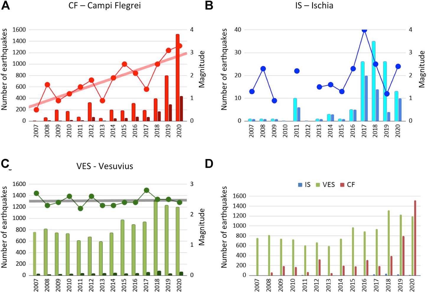
Comparison of the seismicity of the three Neapolitan volcanoes in the period 2007–2020. (A) Histogram of occurrence of earthquakes in Campi Flegrei (all detected events in red and earthquakes of M> = Mc in dark red) and maximum magnitude (red curve). (B) Histogram of occurrence of earthquakes in Ischia (all detected events in cyan and earthquakes of M> = Mc in blue) and maximum magnitude (blue curve). (C) Histogram of occurrence of earthquakes in Vesuvius (all detected events in green and earthquakes with M> = Mc in dark green. For the latter the values on the y axis are multiplied by 2) and maximum magnitude (green curve). Linear trend lines are reported for the maximum magnitude curve in the three volcanoes. (D) Histogram summarizing the occurrence of earthquakes in the three volcanoes. IS = Ischia; Ves = Vesuvius; CF = Campi Flegrei.
TABLE 2
| Area | 2007 | 2008 | 2009 | 2010 | 2011 | 2012 | 2013 | 2014 | 2015 | 2016 | 2017 | 2018 | 2019 | 2020 |
|---|---|---|---|---|---|---|---|---|---|---|---|---|---|---|
| VES | 760 | 817 | 744 | 731 | 608 | 673 | 593 | 743 | 974 | 891 | 938 | 1,315 | 1,227 | 1,195 |
| CF | 1 | 62 | 193 | 174 | 72 | 323 | 48 | 198 | 183 | 315 | 189 | 396 | 799 | 1,520 |
| IS | 1 | 1 | 1 | 0 | 10 | 0 | 1 | 3 | 1 | 5 | 26 | 35 | 26 | 13 |
Earthquakes per year in Vesuvius, Campi Flegrei and Ischia volcanoes in 2007–2020.
In terms of the number of earthquakes, Ischia is the least active volcano in the Neapolitan area (Figure 13A). However, in terms of seismic energy released in January 2007–December 2020, Ischia seismicity is more relevant than that of the other two volcanoes (Figure 13B).
FIGURE 13
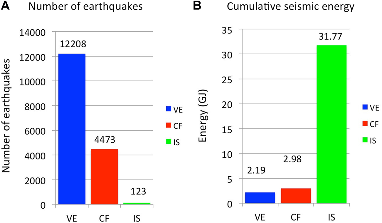
(A) Bar charts showing the number of earthquakes recorded on Vesuvius (blue), Campi Flegrei (red) and Ischia (green) from January 2007 to December 2020. (B) Cumulative energy of the earthquakes from January 2007 to December 2020 of Vesuvius (blue), Campi Flegrei (red) and Ischia (green).
The seismicity of Ischia is interpreted as the effect of a stress field dominated by the gravitational and thermal loading of the block of Mount Epomeo that undergoes rotation northwards and translation southwards by gravitational spreading action (Cubellis et al., 2020). Cubellis et al. (2020) propose for the seismic energy release a stick-slip mechanism as it provides a seismicity of the island characterized by single transients and precludes the generation of significant aftershocks, as it was observed with the earthquake of August 21, 2017.
To compare the recent activity of Neapolitan volcanoes and investigate their differences and similarities we must consider the seismicity in the context of multidisciplinary (geodetic and/or geochemical) observations.
The modern geodetic measurements, made it possible quantifying the subsidence of Ischia (Luongo et al., 1987; Carlino, 2012; Cubellis and Luongo, 2018; Cubellis et al., 2020). In particular the leveling measurements along the coast line established by the Istituto Geografico Militare Italiano (IGMI) in 1913, showed the maximum subsidence in the Serrara Fontana area (Luongo et al., 1987; Manzo et al., 2006; Del Gaudio et al., 2011). For this reason, one of the first permanent GPS stations installed on the island was located in Serrara Fontana (SERR in Figure 4). In 2017 a permanent GPS station was installed on Mount Epomeo (MEPO in Figure 4), which showed a subsidence rate of about 12 mm/year in the summit area of the island, higher than that typically measured at Serrara Fontana. This station allowed measuring a differential subsidence of the island central sector, which corresponds to an associated tilt of the Mount Epomeo block. The northern edge of this block shows a higher subsidence rate (Figure 14A). Seismicity in Ischia is concentrated mainly along the faults bordering the northern edge of the Mount Epomeo block where an important hydrothermal system is active (Casamicciola Terme).
FIGURE 14
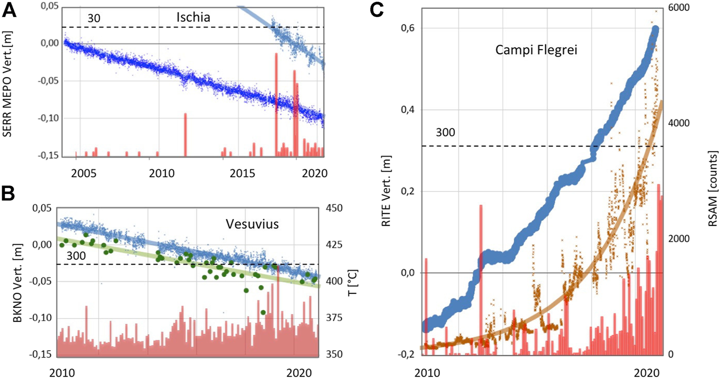
(A) Time series of seismic and geodetic parameters recorded in Ischia from 2004 to 2020. In light blue the daily time series (2017–2020) of the vertical component of MEPO GPS station and in blue the daily time series (2004–2020) of the vertical component of SERR GPS station (see Figure 4 for station locations) in meters (a linear trend line is drawn). In red, the histogram of the monthly occurrence of earthquakes from the catalog of the OC9 station (Figure 4). The dotted horizontal line marks the limit for the histogram scale (30 events/month). (B) Time series of the seismic, geodetic and geochemical parameters recorded at Vesuvius from 2010 to 2020. In blue the daily time series of the vertical component of BKNO GPS station (site VBKN in Figure 2), in meters (a linear trend line is drawn). In green the temperature in Celsius degrees estimated based on the composition of the FC2 and FC5 (since 2018) fumaroles (a linear trend line is drawn). The histogram of the monthly occurrence of earthquakes from the BKE station catalog (Figures 2, 8B) is in red. The dotted horizontal line marks the limit for the histogram scale (300 events/month). (C) Time series of seismic, geodetic and geochemical parameters recorded at Campi Flegrei from 2010 to 2020. In blue the daily time series of the vertical component of the RITE GPS station (Figure 3), in meters. In ocher the amplitude of the fumarolic tremor of the CPIS station, proxy of hydrothermal activity (an exponential trend line is drawn). The histogram of the monthly occurrence of earthquakes from the STH station catalog (Figure 3) is in red. The dotted horizontal line marks the limit for the histogram scale (300 events/month).
Thus, due to the strict relationship between faults and hydrothermal activity, in addition to the peculiar structural factors described above, an important role in the genesis of the Ischia earthquakes is recognized in the dynamics of the hydrothermal system of the Island (Chiodini et al., 2004; D’Auria et al., 2018; Trasatti et al., 2019). Overall, the geochemical investigations have led to general consensus for the existence at Ischia of two distinct geothermal reservoirs, at temperatures of 150–180°C (Panichi et al., 1992; Di Napoli et al., 2009) and 220–280°C, respectively (Panichi et al., 1992; Inguaggiato et al., 2000; Di Napoli et al., 2009). The former, shallower (150–300 m of depth) and colder, is thought to be recharged by either meteoric (to the south; hydrothermal end-member B) or marine (to the west; hydrothermal end-member C) fluids. The hotter (220–280°C) and deeper (∼1,000 m) reservoir would instead reflect a mainly recharge by meteoric water (hydrothermal end-member A; Di Napoli et al., 2009).
At Vesuvius two seismogenic volumes can be recognized: one deeper and one shallower already mentioned in the previous paragraphs (Figure 9A). In recent years the seismicity of the shallow source zone has increased. This seismicity is interpreted as linked to a spreading process (Borgia et al., 2005) that causes the subsidence of the summit area of the volcano (Figure 14B). The crater area of Vesuvius is also affected by hydrothermal manifestations and numerous fumaroles. For this reason, a zone with fluids above sea level is recognized in the edifice, where the shallow seismicity is concentrated. To investigate the effect of the stress field on seismicity, based on the analyzes of the earthquake focal mechanisms and applying different approaches D'Auria et al. (2014) determined spatial variations in the stress field beneath Vesuvius. They find that the stress pattern in the volcanic edifice is consistent with the hypothesis of a seismicity driven by the spreading process. This also agrees with the persistent character of the seismicity located within this volume. Conversely, they find that the stress field in the deep seismogenic volume is consistent with a regional field locally perturbed by the effects of the topography and heterogeneities in the volcanic structure. This seismogenic volume also coincides with the deep hydrothermal system of Vesuvius (Caliro et al., 2011). In any case, the locations of the main swarms, such as those of October 1999 and December 2018 analyzed in this article, show that the two seismogenic volumes, which are elongated in the direction of the crater axis, are interconnected and represent two portions of a conduit-like structure in the central zone of Vesuvius (Figure 9), where the transport of fluids takes place.
Other evidences suggest the important role of the fluids circulating in the volcano apparatus in the genesis of the Vesuvius seismicity. It is worth to note that, after the last eruption of 1944, the seismicity began in 1966 concurrently with important variations of the temperature of the fumaroles that progressively decreased from the high values measured from 1944 to 1966 (up to 800°C) to temperatures close to the boiling point of water after the 1990s (Chiodini et al., 2001b). This behavior was interpreted as the arrival into the hot volcanic conduits of groundwaters of meteoric origin that increased fluid pressure and in turn started to trigger seismicity (Del Pezzo et al., 2013; D’Auria et al., 2013). In the case of the most energetic event of the post 1944 period (M 3.6 in 1999) there are evidences of the involvement of deep magmatic fluids. The event was in fact followed by a clear increase of the CO2 flux in the crater, as well as by peaks of the CO2/CH4 fumarolic ratio (a good indicator of the input of magmatic fluids; Chiodini, 2009) and of the PCO2 estimated by gas equilibria applied to the Vesuvius fumaroles (Caliro et al., 2011; Del Pezzo et al., 2013). Similarly, the LP transient recorded on November 16, 2020, which we located in the lower part of the deep seismogenic volume (Figure 9) at the base of the hydrothermal system, probably represents an event caused by the injection of deeper magmatic fluids into the shallower parts of the hydrothermal system.
The recent seismicity of Campi Flegrei accompanies the current uplift phase, which began in 2005, and the remarkable geochemical changes taking place in the area (Figure 14C). Most earthquakes are concentrated at shallow depth (generally <2 km) in the subsoil of the Solfatara-Pisciarelli hydrothermal site (Figure 7) a piece of evidence that alone indicates the strict link between seismicity and hydrothermal activity. This aspect has been studied for a long time at the Campi Flegrei where the first hypotheses on the possible link between the dynamics of caldera and the fluids in the subsoil were born thanks to Babbage. (1847). In recent times, a link between unrest and fluids had been proposed by Bonafede. (1991) to explain several geochemical and geophysical observations made during the bradyseismic crisis of 1982–1984. Subsequently, an extensive literature has developed on this topic (eg: Macedonio et al., 2014; Giudicepietro et al., 2016; Giudicepietro et al., 2017), the detailed analysis of which is beyond the scope of this article. The relationships between seismicity and fluids were, for example, investigated by D’Auria et al. (2011) finding that fluid-transfer episodes are a primary factor causing the Campi Flegrei seismicity in the 1989–2010 period. Successively it was shown how, in 2000–2016, the cumulative background seismicity (Figure 5C) follows the same evolution of the fumarolic indicator of the hydrothermal temperature-pressure (see Figure 4 in Chiodini et al., 2017b). A link between seismicity and activity of the hydrothermal system was recently stressed in Giudicepietro et al. (2021), which recognize a valve-like mechanism highlighted by the sudden step in the fumarolic tremor amplitude in coincidence with two seismic swarms (October 7, 2015 and December 6, 2019). This mechanism suggests an abrupt increase in the transport of fluids to the surface, through a conduit-like path, where the swarms are located. The analysis of the swarm of April 26, 2020 (the most remarkable in terms of energy in the last 37 years) carried out in this paper highlights a further reactivation of the conduit-like seismogenic structure, on which are located the largest earthquakes occurred after the 1982–84 crisis in the Campi Flegrei. This structure develops from the depth in line with the hydrothermal area of Pisciarelli, the most significant fumarolic manifestation of the Phlegraean caldera, which is among the most important volcanic emissions in the world (Chiodini et al., 2021).
The aspects discussed so far show how the three Neapolitan volcanoes have different structural characteristics, different local stress fields and different states of activity. It is worth noting that the different geometries in the distribution of the earthquake hypocenters, in Ischia along faults and in Campi Flegrei and Vesuvius mainly along conduit-like paths, are consistent with the strong emissions of non-condensable gas (CO2) in the Solfatara and Vesuvius and the absence of important emissions of this type in Ischia. Actually, the hydrothermal fluids emitted in Ischia are dominated by water (water vapor) of meteoric and/or marine shallow origin (Chiodini et al., 2004; Di Napoli et al., 2009). On the contrary, in the Campi Flegrei and Vesuvius, where seismicity delineates conduit-like structures, a greater contribution of magma degassing can be recognized in the geochemical data (Caliro et al., 2007; Caliro et al., 2011). In the light of these geochemical clues we interpret the seismicity along conduits of Campi Flegrei and Vesuvius as the outline of magmatic fluids propagation paths from the depths toward the emission zones.
Conclusion
We analyzed the seismic data of Vesuvius, Campi Flegrei and Ischia. We studied occurrence, magnitude and energy temporal evolutions of the earthquakes in the three Neapolitan volcanoes. Furthermore, we analyzed the magnitude-frequency distributions to derive the Mc and the b-values for the three volcanoes and we relocated some significant seismic swarms that occurred in Campi Flegrei and Vesuvius. We also located a LP transient recorded at Vesuvius on November 16, 2020.
We found that the seismicity of the three volcanoes had different characteristics and different temporal evolutions in recent years. Actually, in Ischia the seismicity is distributed along fault zones, predominantly in the northern sector of the Island (Casamicciola Terme), whereas in Vesuvius most of the seismicity is concentrated below the crater, outlining a continuous axial structure that coincides with the fluid path from the deep hydrothermal system, where we also located the November 16, 2020 LP event, toward the emission zones (Frondini et al., 2004). A similar pattern can be recognized also at Campi Flegrei, where earthquakes are mainly concentrated below the high hydrothermal fluid emission area of the Solfatara in Pozzuoli (Chiodini et al., 2001b; Cardellini et al., 2017; Chiodini et al., 2021). In particular the relocations of the April 26, 2020 earthquakes, compared with those of two swarms that occurred in 2015 and 2019 (Figure 7) (Giudicepietro et al., 2021), confirm that the main seismic swarms in Campi Flegrei delineate a conduit-like path through which hydrothermal fluids transfer from depth to Solfatara-Pisciarelli area. Furthermore, a common distinctive feature of Campi Flegrei and Vesuvius is the imprinting of magmatic degassing, in contrast with the hydrothermal systems typical of Ischia, that are dominated by meteoric or sea waters.
Nevertheless all of these volcanoes also show similarities. In all three volcanoes we can recognize an essential contribution of hydrothermal systems in the generation of earthquakes (Chiodini et al., 2004; D’Auria et al., 2011; D’Auria et al., 2018; Chiodini et al., 2021). This condition has also been recognized in other volcanoes, e.g. in Iceland (White et al., 2011; Greenfield and White, 2015) and in Mammoth Mountain (Hotovec-Ellis et al., 2018), and may be a common seismogenic factor in closed-conduit volcanoes.
Concerning the state of activity of the Neapolitan volcanoes, the seismicity of Ischia showed a decreasing trend after the M4.0 earthquake (August 21, 2017) sequence. On the contrary, the increase of seismicity in the Campi Flegrei characterized a long-term unrest that has shown acceleration in the last 2 years. Since 2018, also Vesuvius has shown an increase in the number of earthquakes per year, which suggests a possible increase in activity of this volcano.
Statements
Data availability statement
The original contributions presented in the study are included in the article/Supplementary Material, further inquiries can be directed to the corresponding author.
Author contributions
FG, GC, LP, AT and GM conceptualization, article writing. FG, PR, FB, SC, EC, LD, WC, PM, AE, DG, GM, DB, AT and GC data analysis, interpretation of results, article revising; FG, PR, SC, WC,PM, GM, DB, MO, RP, GS, AT and GC dataset preparation and article revising. All authors contributed in article revising.
Funding
This work benefited from funds of the EU (DG ECHO) Project EVE n. 826292 and was partially supported by the project Progetto Strategico Dipartimentale INGV 2019. “Linking surface Observables to sub–Volcanic plumbing-system: A multidisciplinary approach for Eruption forecasting at Campi Flegrei caldera (Italy)”. GM, FG and AT benefited from funding from the INGV Project “Ricerca Libera 2019–Study of the physical properties of the shallow structure of Vesuvius based on the analysis of seismic data.”
Acknowledgments
The authors wish to thank all the many colleagues who have contributed to the monitoring effort on CF, Vesuvius and Ischia. The authors are particularly indebted to the Istituto Nazionale di Geofisica e Vulcanologia (INGV) technical staff ensuring the regular working of the multidisciplinary monitoring networks. The data used in this study were provided by the Istituto Nazionale di Geofisica e Vulcanologia (Osservatorio Vesuviano). The authors are also grateful to the Italian Presidenza del Consiglio dei Ministri-Dipartimento della Protezione Civile (DPC) for supporting the monitoring activities at CF. This article does not necessarily represent DPC official opinion and policies.
Conflict of interest
The authors declare that the research was conducted in the absence of any commercial or financial relationships that could be construed as a potential conflict of interest.
Supplementary material
The Supplementary Material for this article can be found online at: https://www.frontiersin.org/articles/10.3389/feart.2021.662113/full#supplementary-material
References
1
AcocellaV.FunicielloR. (1999). The Interaction between Regional and Local Tectonics during Resurgent Doming: the Case of the Island of Ischia, Italy. J. Volcanology Geothermal Res.88, 109–123. 10.1016/S0377-0273(98)00109-7
2
AcocellaV.FunicielloR. (2006). Transverse Systems along the Extensional Tyrrhenian Margin of central Italy and Their Influence on Volcanism. Tectonics25 (2). 10.1029/2005tc001845
3
AiuppaA.AvinoR.BruscaL.CaliroS.ChiodiniG.D'AlessandroW.et al (2006). Mineral Control of Arsenic Content in thermal Waters from Volcano-Hosted Hydrothermal Systems: Insights from Island of Ischia and Phlegrean Fields (Campanian Volcanic Province, Italy). Chem. Geology229, 313–330. 10.1016/J.CHEMGEO.2005.11.004
4
AkiK. (1965). Maximum Likelihood Estimate of B in the Formula Log N=a-b M and its Confidence Limits. Bull. Earthquake Res. Inst.43, 237–239.
5
AlbertP. G.GiaccioB.IsaiaR.CostaA.NiespoloE. M.NomadeS.et al (2019). Evidence for a Large-Magnitude Eruption from Campi Flegrei Caldera (Italy) at 29 Ka. Geology47, 595–599. 10.1130/G45805.1
6
AlfanoG. B.FriedlaenderI. (1929). La storia del Vesuvio illustrata dai documenti coevi. Ulm a.d. Donau, Germany: Karl Hohn, 69.
7
AmorusoA.CrescentiniL.SabbettaI. (2014). Paired Deformation Sources of the Campi Flegrei Caldera (Italy) Required by Recent (1980-2010) Deformation History. J. Geophys. Res. Solid Earth119, 858–879. 10.1002/2013JB010392
8
ArnòV.PrincipeC.RosiM.SantacroceR.SbranaA.SheridanM. F. (1987). “Eruptive History,” in Somma- Vesuvius, Quaderni de La Ricerca Scientifica. Editor SantacroceR. (Roma: CNR), 53–103.
9
AugerE.GaspariniP.VirieuxJ.ZolloA. (2001). Seismic Evidence of an Extended Magmatic Sill under Mt. Vesuvius. Science294, 1510–1512. 10.1126/science.1064893
10
BabbageC. (1847). Observations on the temple of Serapis, at Pozzuoli, Near Naples, with Remarks on Certain Causes Which May Produce Geological Cycles of Great Extent. Q. J. Geol. Soc.3, 186–217. 10.1144/GSL.JGS.1847.003.01-02.22
11
BarattaM. (1897). Il Vesuvio e le sue eruzioni. Roma: Società Editrice Dante Alighieri, 203.
12
BarbieriM.Di GirolamoP.LocardiE.LombardiG.StanzioneD. (1979). Petrology of the Calc-Alkaline Volcanics of the Parete 2 Well (Campania, Italy). Period. Mineral.48, 53–74.
13
BerrinoG.CorradoG.RiccardiU. (1998). Sea Gravity Data in the Gulf of Naples: a Contribution to Delineating the Structural Pattern of the Vesuvian Area. J. Volcanology Geothermal Res.82, 139–150. 10.1016/S0377-0273(97)00061-9
14
BerrinoG.CorradoG.RiccardiU. (2008). Sea Gravity Data in the Gulf of Naples. A Contribution to Delineating the Structural Pattern of the Phlegraean Volcanic District. J. Volcanology Geothermal Res.175, 241–252. 10.1016/j.jvolgeores.2008.03.007
15
BonafedeM. (1991). Hot Fluid Migration: an Efficient Source of Ground Deformation: Application to the 1982-1985 Crisis at Campi Flegrei-Italy. J. Volcanology Geothermal Res.48, 187–198. 10.1016/0377-0273(91)90042-x
16
BorgiaA.TizzaniP.SolaroG.ManzoM.CasuF.LuongoG.et al (2005). Volcanic Spreading of Vesuvius, a New Paradigm for Interpreting its Volcanic Activity. Geophys. Res. Lett.32, L03303. 10.1029/2004GL022155
17
BracciniG. C. (1632). Dell’incendio fattosi al Vesuvio XVI Dicembre 1631, e delle sue cause ed effetti (Napoli: S. Roncagliolo).
18
BrocchiniD.PrincipeC.CastradoriD.LaurenziM. A.GorlaL. (2001). Quaternary Evolution of the Southern Sector of the Campanian Plain and Early Somma-Vesuvius Activity: Insights from the Trecase 1 Well. Mineralogy Pet.73, 67–91. 10.1007/s007100170011
19
BrownR. J.OrsiG.de VitaS. (2008). New Insights into Late Pleistocene Explosive Volcanic Activity and Caldera Formation on Ischia (Southern Italy). Bull. Volcanol.70, 583–603. 10.1007/s00445-007-0155-0
20
BrunoP. P. G.de AlteriisG.FlorioG. (2002). The Western Undersea Section of the Ischia Volcanic Complex (Italy, Tyrrhenian Sea) Inferred by marine Geophysical Data. Geophys. Res. Lett.29, 57-1–57-4. 10.1029/2001GL013904
21
BrunoP. P. G.RapollaA.Di FioreV. (2003). Structural Setting of the Bay of Naples (Italy) Seismic Reflection Data: Implications for Campanian Volcanism. Tectonophysics372 (3-4), 193–213. 10.1016/s0040-1951(03)00327-5
22
CaliroS.ChiodiniG.AvinoR.MinopoliC.BocchinoB. (2011). Long Time-Series of Chemical and Isotopic Compositions of Vesuvius Fumaroles: Evidence for Deep and Shallow Processes. Ann. Geophys-italy54, 137–149. 10.4401/ag-5034
23
CaliroS.ChiodiniG.MorettiR.AvinoR.GranieriD.RussoM.et al (2007). The Origin of the Fumaroles of La Solfatara (Campi Flegrei, South Italy). Geochimica et Cosmochimica Acta71 (12), 3040–3055. 10.1016/j.gca.2007.04.007
24
CardelliniC.ChiodiniG.FrondiniF.AvinoR.BagnatoE.CaliroS.et al (2017). Monitoring Diffuse Volcanic Degassing during Volcanic Unrests: the Case of Campi Flegrei (Italy). Sci. Rep.7, 6757. 10.1038/s41598-017-06941-2
25
CarlinoS.CubellisE.LuongoG.ObrizzoF. (2006). “On the Mechanics of Caldera Resurgence of Ischia Island (Southern Italy),” in Mechanisms of Activity and Unrest at Large Calderas. Editors TroiseC.De NataleG.KilburnC. R. J. (London: Geological Society), 269, 181–193. 10.1144/GSL.SP.2006.269.01.12
26
CarlinoS.PinoN. A.TramelliA.De NovellisV.ConvertitoV. (2021). A Common Source for the Destructive Earthquakes in the Volcanic Island of Ischia (Southern Italy): Insights from Historical and Recent Seismicity. Nat. Hazards2021, 1–25. 10.1007/s11069-021-04675-z
27
CarlinoS. (2012). The Process of Resurgence for Ischia Island (Southern Italy) since 55 Ka: the Laccolith Model and Implications for Eruption Forecasting. Bull. Volcanol.74, 947–961. 10.1007/s00445-012-0578-0
28
ChiodiniG.AvinoR.BrombachT.CaliroS.CardelliniC.de VitaS.et al (2004). Fumarolic and Diffuse Soil Degassing West of Mount Epomeo, Ischia, Italy. J. Volcanology Geothermal Res.133, 291–309. 10.1016/S0377-0273(03)00403-7
29
ChiodiniG.CaliroS.AvinoR.BiniG.GiudicepietroF.De CesareW.et al (2021). Hydrothermal Pressure-Temperature Control on CO2 Emissions and Seismicity at Campi Flegrei (Italy). J. Volcano. Geotherm. Res.414, 107245. 10.1016/j.jvolgeores.2021.107245
30
ChiodiniG.CaliroS.De MartinoP.AvinoR.GherardiF. (2012). Early Signals of New Volcanic Unrest at Campi Flegrei Caldera? Insights from Geochemical Data and Physical Simulations. Geology40, 943–946. 10.1130/G33251.1
31
ChiodiniG. (2009). CO2/CH4 Ratio in Fumaroles a Powerful Tool to Detect Magma Degassing Episodes at Quiescent Volcanoes. Geophys. Res. Lett.36, L02302. 10.1029/2008GL036347-X
32
ChiodiniG.FrondiniF.CardelliniC.GranieriD.MariniL.VenturaG. (2001a). CO2 degassing and Energy Release at Solfatara Volcano, Campi Flegrei, Italy. J. Geophys. Res.106, 16213–16221. 10.1029/2001JB000246-X
33
ChiodiniG.GiudicepietroF.VandemeulebrouckJ.AiuppaA.CaliroS.De CesareW.et al (2017a). Fumarolic Tremor and Geochemical Signals during a Volcanic Unrest. Geology45, 1131–1134. 10.1130/G39447.1
34
ChiodiniG.MariniL.RussoM. (2001b). Geochemical Evidence for the Existence of High-Temperature Hydrothermal Brines at Vesuvio Volcano, Italy. Geochimica et Cosmochimica Acta65, 2129–2147. 10.1016/S0016-7037(01)00583-X
35
ChiodiniG.PaonitaA.AiuppaA.CostaA.CaliroS.De MartinoP.et al (2016). Magmas Near the Critical Degassing Pressure Drive Volcanic Unrest towards a Critical State. Nat. Commun.7, 13712. 10.1038/ncomms13712
36
ChiodiniG.SelvaJ.Del PezzoE.MarsanD.De SienaL.D’AuriaL.et al (2017b). Clues on the Origin of post-2000 Earthquakes at Campi Flegrei Caldera (Italy). Sci. Rep.7, 4472. 10.1038/s41598-017-04845-9
37
ChouetB. A.MatozaR. S. (2013). A Multi-Decadal View of Seismic Methods for Detecting Precursors of Magma Movement and Eruption. J. Volcanology Geothermal Res.252, 108–175. 10.1016/j.jvolgeores.2012.11.013
38
CivettaL.GalloG.OrsiG. (1991). Sr- and Nd-Isotope and Trace-Element Constraints on the Chemical Evolution of the Magmatic System of Ischia (Italy) in the Last 55 Ka. J. Volcanology Geothermal Res.46, 213–230. 10.1016/0377-0273(91)90084-D
39
ConticelliS.LaurenziM. A.GiordanoG.MatteiM.AvanzinelliR.MellusoL.et al (2010). “Leucite-bearing (Kamafugitic/leucititic) and -free (Lamproitic) Ultrapotassic Rocks and Associated Shoshonites from Italy: Constraints on Petrogenesis and Geodynamics,” in The Geology of Italy: Tectonics and Life along Plate Margins. Editors BeltrandoM.PeccerilloA.MatteiM.ConticelliS.DoglioniC. (Clear Range, NSW, Australia: Journal of the Virtual Explorer), 1–95. 10.3809/jvirtex.2010.00251
40
CubellisE.CarlinoS.IannuzziR.LuongoG.ObrizzoF. (2004). Management of Historical Seismic Data Using GIS: The Island of Ischia (Southern Italy). Nat. Hazards33, 379–393. 10.1023/B:NHAZ.0000048465.40413.17
41
CubellisE.Del GaudioC.FerriM.GrimaldiM.ObrizzoF.RiccoC.et al (1991). Gravity Anomalies in the Campanian Plain (Southern Italy) and Their Volcano-Tectonic Implications. Acta Vulcanol1, 57–62.
42
CubellisE.Di DonnaG.LuongoG.MazzarellaA. (2002). Simulating the Mechanism of Magmatic Processes in the Campi Flegrei Area (Southern Italy) by the Lorenz Equations. J. Volcanology Geothermal Res.115, 339–349. 10.1016/S0377-0273(01)00330-4
43
CubellisE.FerriM.LuongoG. (1995). Internal Structures of the Campi Flegrei Caldera by Gravimetric Data. J. Volcanology Geothermal Res.65, 147–156. 10.1016/0377-0273(94)00047-K
44
CubellisE.LuongoG. (2018). History of Ischian Earthquakes. Napoli, Italy: Bibliopolis, 140.
45
CubellisE.LuongoG. (1998). “Il Contesto Fisico,” in AAVV., Il terremoto del 28 luglio 1883 a Casamicciola nell’isola d’Ischia, Presidenza del Consiglio dei Ministri - Servizio Sismico Nazionale (Roma: Istituto Poligrafico e Zecca dello Stato), 49–123.
46
CubellisE.LuongoG.MarturanoA. (2007). Seismic hazard Assessment at Mt. Vesuvius: Maximum Expected Magnitude. J. Volcanology Geothermal Res.162, 139–148. 10.1016/j.jvolgeores.2007.03.003
47
CubellisE.LuongoG.ObrizzoF.SepeV.TammaroU. (2020). Contribution to Knowledge Regarding the Sources of Earthquakes on the Island of Ischia (Southern Italy). Nat. Hazards100, 955–994. 10.1007/s11069-019-03833-8
48
CubellisE.MarturanoA. (2013). Felt index, Source Parameters and Ground Motion Evaluation for Earthquakes at Mt. Vesuvius. Volume Speciale "Mt. Vesuvius Monitoring: the State of the Art and Perspectives. Ann. Geophys.56 (4), S0439. 10.4401/ag-6445
49
CubellisE.MarturanoA. (2002). Mt. Vesuvius: a Macroseismic Study of the Earthquake of 9 October 1999. J. Volcanology Geothermal Res.118, 339–351. 10.1016/S0377-0273(02)00301-3
50
CubellisE.MarturanoA.PappalardoL. (2013). Le ceneri distali dell’eruzione del Vesuvio del marzo 1944 raccolte a Devoli (Albania). Quad. Geofis.113, 1–35.
51
CubellisE.MarturanoA.PappalardoL. (2016). The Last Vesuvius Eruption in March 1944: Reconstruction of the Eruptive Dynamic and its Impact on the Environment and People through Witness Reports and Volcanological Evidence. Nat. Hazards82 (1), 95–121. 10.1007/s11069-016-2182-7
52
CusanoP.PetrosinoS.BiancoF.Del PezzoE. (2013). The First Long Period Earthquake Detected in the Background Seismicity at Mt. Vesuvius. Ann. Geophys.55 (4), S0440. 10.4401/ag-6447
53
D'AuriaL.GiudicepietroF.AquinoI.BorrielloG.Del GaudioC.Lo BascioD.et al (2011). Repeated Fluid-Transfer Episodes as a Mechanism for the Recent Dynamics of Campi Flegrei Caldera (1989-2010). J. Geophys. Res.116, B04313. 10.1029/2010JB007837
54
D'AuriaL.GiudicepietroF.TramelliA.RicciolinoP.BascioD. L.OraziM.et al (2018). The Seismicity of Ischia Island. Seismol. Res. Lett.89, 1750–1760. 10.1785/0220180084
55
D'AuriaL.MassaB.MatteoA. D. (2014). The Stress Field beneath a Quiescent Stratovolcano: The Case of Mount Vesuvius. J. Geophys. Res. Solid Earth119, 1181–1199. 10.1002/2013JB010792
56
D'AuriaL.MassaB. (2015). Stress Inversion of Focal Mechanism Data Using a Bayesian Approach: A Novel Formulation of the Right Trihedra Method. Seismological Res. Lett.86, 968–977. 10.1785/0220140153
57
D’AuriaL.EspositoA. M.Lo BascioD.RicciolinoP.GiudicepietroF.MartiniM.et al (2013). The Recent Seismicity of Mt. Vesuvius: Inference on Seismogenic Processes. Ann. Geophys-italy56, S0442. 10.4401/ag-6448
58
De MartinoP.GuardatoS.DonnarummaG. P.DolceM.TrombettiT.ChiericiF.et al (2020). Four Years of Continuous Seafloor Displacement Measurements in the Campi Flegrei Caldera. Front. Earth Sci.8. 10.3389/feart.2020.615178
59
De MartinoP.TammaroU.ObrizzoF. (2014). GPS Time Series at Campi Flegrei Caldera (2000-2013). Ann. Geophys-italy57, S0213. 10.4401/ag-6431
60
De MartinoP.TammaroU.ObrizzoF.SepeV.BrandiG.D’AlessandroA.et al (2011). La rete GPS dell’isola d’Ischia: deformazioni del suolo in un’area vulcanica attiva (1998-2010). Quad. Geofis.95, 61..
61
De NataleG.TroiseC.PingueF.MastrolorenzoG.PappalardoL.BattagliaM.et al (2006b). “The Campi Flegrei Caldera: Unrest Mechanisms and Hazards,” in Mechanisms of Activity and Unrest at Large Calderas. Editors TroiseC.De NataleG.KilburnC. R. J. (London: Geological Society), 269, 25–45. 10.1144/gsl.sp.2006.269.01.03Geol. Soc. Lond. Spec. Publications
62
De NovellisV.CarlinoS.CastaldoR.TramelliA.De LucaC.PinoN. A.et al (2018). The 21 August 2017 Ischia (Italy) Earthquake Source Model Inferred from Seismological, GPS, and DInSAR Measurements. Geophys. Res. Lett.45, 2193–2202. 10.1002/2017GL076336
63
de VitaS.SansiveroF.OrsiG.MarottaE.PiochiM. (2010). Volcanological and Structural Evolution of the Ischia Resurgent Caldera (Italy) over the Past 10 k.Y. Geol. Soc. Am. Spec. Paper464, 193–241. 10.1130/2010.2464(10
64
De VivoB.RolandiG.GansP. B.CalvertA.BohrsonW. A.SperaF. J.et al (2001). New Constraints on the Pyroclastic Eruptive History of the Campanian Volcanic Plain (Italy). Mineralogy Pet.73, 47–65. 10.1007/s007100170010
65
DeinoA. L.OrsiG.de VitaS.PiochiM. (2004). The Age of the Neapolitan Yellow Tuff Caldera-Forming Eruption (Campi Flegrei Caldera - Italy) Assessed by 40Ar/39Ar Dating Method. J. Volcanology Geothermal Res.133, 157–170. 10.1016/S0377-0273(03)00396-2
66
Del GaudioC.AquinoI.RicciardiG. P.RiccoC.ScandoneR. (2010). Unrest Episodes at Campi Flegrei: A Reconstruction of Vertical Ground Movements during 1905-2009. J. Volcanology Geothermal Res.195, 48–56. 10.1016/j.jvolgeores.2010.05.014
67
Del GaudioC.AquinoI.RiccoC.SepeV.SerioC. (2011). Monitoraggio geodetico dell’isola d’Ischia: risultati della livellazione geometrica di precisione eseguita a giugno 2010. Quad. Geofis.87, 1–20.
68
Del PezzoE.ChiodiniG.CaliroS.BiancoF.AvinoR. (2013). New Insights into Mt. Vesuvius Hydrothermal System and its Dynamic Based on a Critical Review of Seismic Tomography and Geochemical Features. Ann. Geophys-italy56, S0444. 10.4401/ag-6450
69
DenataleG.TroiseC.PingueF.MastrolorenzoG.PappalardoL. (2006a). The Somma-Vesuvius Volcano (Southern Italy): Structure, Dynamics and hazard Evaluation. Earth-Science Rev.74, 73–111. 10.1016/j.earscirev.2005.08.001
70
DevotiR.De MartinoP.PietrantonioG.DolceM. (2018). Coseismic Displacements on Ischia Island, Real-Time GPS Positioning Constraints on Earthquake Source Location. Ann. Geophys-italy61, SE337. 10.4401/ag-7656
71
Di NapoliR.AiuppaA.BellomoS.BruscaL.D'AlessandroW.CandelaE. G.et al (2009). A Model for Ischia Hydrothermal System: Evidences from the Chemistry of thermal Groundwaters. J. Volcanology Geothermal Res.186, 133–159. 10.1016/j.jvolgeores.2009.06.005
72
Di RenzoV.Di VitoM. A.ArienzoI.CarandenteA.CivettaL.D'antonioM.et al (2007). Magmatic History of Somma-Vesuvius on the Basis of New Geochemical and Isotopic Data from a Deep Borehole (Camaldoli Della Torre). J. Pet.48, 753–784. 10.1093/petrology/egl081
73
Di VitoM. A.AcocellaV.AielloG.BarraD.BattagliaM.CarandenteA.et al (2016). Magma Transfer at Campi Flegrei Caldera (Italy) before the 1538 AD Eruption. Sci. Rep.6, 32245. 10.1038/srep32245
74
EndoE. T.MurrayT. (1991). Real-time Seismic Amplitude Measurement (RSAM): A Volcano Monitoring and Prediction Tool. Bull. Volcanol53, 533–545. 10.1007/BF00298154
75
EspositoA. M.AlaiaG.GiudicepietroF.PappalardoL.D’AntonioM. (2020a). “Unsupervised Geochemical Analysis of the Eruptive Products of Ischia, Vesuvius and Campi Flegrei,” in Progresses in Artificial Intelligence and Neural Systems. 189. Editors EspositoA.Faundez-ZanuyM.MorabitoF.PaseroE. (Singapore: Springer), 175–184. 10.1007/978-981-15-5093-5_17
76
EspositoA. M.De BernardoA.FerraraS.GiudicepietroF.PappalardoL. (2020b). “SOM-based Analysis of Volcanic Rocks: An Application to Somma-Vesuvius and Campi Flegrei Volcanoes (Italy),” in Neural Approaches to Dynamics of Signal Exchanges. 151. Editors EspositoA.Faundez-ZanuyM.MorabitoF.PaseroE. (Singapore: Springer), 55–60. 10.1007/978-981-13-8950-4_6
77
FrondiniF.ChiodiniG.CaliroS.CardelliniC.GranieriD.VenturaG. (2004). Diffuse CO2 Degassing at Vesuvio, Italy. Bull. Volcanol66 (7), 642–651. 10.1007/s00445-004-0346-x
78
GebauerS. K.SchmittA. K.PappalardoL.StockliD. F.LoveraO. M. (2014). Crystallization and Eruption Ages of Breccia Museo (Campi Flegrei Caldera, Italy) Plutonic Clasts and Their Relation to the Campanian Ignimbrite. Contrib. Mineral. Petrol.167, 953. 10.1007/s00410-013-0953-7
79
GiudicepietroF.ChiodiniG.AvinoR.BrandiG.CaliroS.De CesareW.et al (2021). Tracking Episodes of Seismicity and Gas Transport in Campi Flegrei Caldera through Seismic, Geophysical, and Geochemical Measurements. Seismol. Res. Lett.92, 965–975. (in press). 10.1785/0220200223
80
GiudicepietroF.ChiodiniG.CaliroS.De CesareW.EspositoA. M.GalluzzoD.et al (2019). Insight into Campi Flegrei Caldera Unrest through Seismic Tremor Measurements at Pisciarelli Fumarolic Field. Geochem. Geophys. Geosyst.20, 5544–5555. 10.1029/2019GC008610
81
GiudicepietroF.MacedonioG.D’AuriaL.MartiniM. (2016). Insight into Vent Opening Probability in Volcanic Calderas in the Light of a Sill Intrusion Model. Pure Appl. Geophys.173, 1703–1720. 10.1007/s00024-015-1190-y
82
GiudicepietroF.MacedonioG.MartiniM. (2017). A Physical Model of Sill Expansion to Explain the Dynamics of Unrest at Calderas with Application to Campi Flegrei. Front. Earth Sci.5, 1–11. 10.3389/feart.2017.00054
83
GiudicepietroF.OraziM.ScarpatoG.PelusoR.D'AuriaL.RicciolinoP.et al (2010). Seismological Monitoring of Mount Vesuvius (Italy): More Than a century of Observations. Seismological Res. Lett.81, 625–634. 10.1785/gssrl/81.4.62510.1785/gssrl.81.4.625
84
GreenfieldT.WhiteR. S. (2015). Building Icelandic Igneous Crust by Repeated Melt Injections. J. Geophys. Res. Solid Earth120 (11), 7771–7788. 10.1002/2015jb012009
85
GuidoboniE.CiuccarelliC. (2011). The Campi Flegrei Caldera: Historical Revision and New Data on Seismic Crises, Bradyseisms, the Monte Nuovo Eruption and Ensuing Earthquakes (Twelfth century 1582 AD). Bull. Volcanol.73, 655–677. 10.1007/s00445-010-0430-3
86
GuidoboniE. (2008). Vesuvius: A Historical Approach to the 1631 Eruption “Cold Data” from the Analysis of Three Contemporary Treatises. J. Volcanology Geothermal Res.178, 347–358. 10.1016/j.jvolgeores.2008.09.020
87
Hotovec-EllisA. J.ShellyD. R.HillD. P.PittA. M.DawsonP. B.ChouetB. A. (2018). Deep Fluid Pathways beneath Mammoth Mountain, California, Illuminated by Migrating Earthquake Swarms. Sci. Adv.4 (8), eaat5258. 10.1126/sciadv.aat5258
88
IannacconeG.GuardatoS.DonnarummaG. P.De MartinoP.DolceM.MacedonioG.et al (2018). Measurement of Seafloor Deformation in the marine Sector of the Campi Flegrei Caldera (Italy). J. Geophys. Res. Solid Earth123, 66–83. 10.1002/2017JB014852
89
ImbòG.CasertanoL.BonasiaV. (1964). Considerazioni sismogravimetriche sulle manifestazioni vesuviane del Maggio 1964. Annali Osservatorio Vesuviano6, 177–188.
90
ImbòG. (1964). Recenti Manifestazioni Dell’attività Vesuviana. Atti Accademia Pontiniana13, 3–6.
91
ImbòG. (1954). Sismicità del parossismo Vesuviano del marzo 1944. Annali Osservatorio Vesuviano, Napoli, Italy1, 1–211.
92
ImprotaL.CorciuloM. (2006). Controlled Source Nonlinear Tomography: A Powerful Tool to Constrain Tectonic Models of the Southern Apennines Orogenic Wedge, Italy. Geol34, 941–944. 10.1130/G22676A.1
93
InguaggiatoS.PecorainoG.D'AmoreF. (2000). Chemical and Isotopical Characterisation of Fluid Manifestations of Ischia Island (Italy). J. Volcanology Geothermal Res.99, 151–178. 10.1016/S0377-0273(00)00158-X
94
JohnsonC. E. (2020). Beyond Earthworm: Keeping the Promise. Seismol. Res. Lett.91, 581–584. 10.1785/0220190198
95
JohnsonC. E.BittenbinderA.BogaertB.DietzL.KohlerW. (1995). Newsletter April, 1995. Anesth. Hist. Assoc. Newsl.13, 1–16. 10.1016/s1089-9634(95)50110-0
96
KrischerL.MegiesT.BarschR.BeyreutherM.LecocqT.CaudronC.et al (2015). ObsPy: A Bridge for Seismology into the Scientific Python Ecosystem. Comput. Sci. Disc.8 (1), 014003. 10.1088/1749‐4699/8/1/014003
97
LeeW. H. K.LahrJ. C. (1975). HYPO71 (Revised): A Computer Program for Determining Hypocenter, Magnitude and First Motion Pattern of Local Earthquakes. U.S. Geol. Surv. Open-File Rep.75-311, 116. 10.3133/ofr75311
98
LuongoG.CarlinoS.CubellisE.DeliziaI.ObrizzoF. (2012). Casamicciola 1883 - Il sisma tra interpretazione scientifica e scelte politiche. Naples, Italy: Bibliopolis, 282.
99
LuongoG.CubellisE.ObrizzoF. (1987). Ischia storia di un’isola vulcanica. Napoli: Liguori Editore, 164.
100
MacedonioG.GiudicepietroF.D'AuriaL.MartiniM. (2014). Sill Intrusion as a Source Mechanism of Unrest at Volcanic Calderas. J. Geophys. Res. Solid Earth119, 3986–4000. 10.1002/2013JB010868
101
ManzoM.RicciardiG. P.CasuF.VenturaG.ZeniG.BorgströmS.et al (2006). Surface Deformation Analysis in the Ischia Island (Italy) Based on Spaceborne Radar Interferometry. J. Volcanology Geothermal Res.151, 399–416. 10.1016/j.jvolgeores.2005.09.010
102
MarturanoA. (2006). “Chapter 4 Geophysical Precursors at Vesuvius from Historical and Archeological Sources,” in Vesuvius, Education, Security and prosperity. Editor DobranF. (Elsevier), 249–263. 10.1016/s1871-644x(06)80008-2
103
MarturanoA.ScaramellaP. (1998). “The Role of Primary Sources in Reconstructing the History of Volcanoes: the Eruption of Vesuvius in 1631,” in Volcanoes and History. Editor MorelloN. (Genova, Italy: Brigati), 281–299.
104
NiccoliniA. (1846). Descrizione della gran Terma Puteolana volgarmente detta Tempio di Serapide. Napoli: Forgotten Books.
105
NiccoliniA. (1829). Rapporto sulle acque che invadono il pavimento dell’antico edifizio detto Tempio di Serapide. Napoli: Stamperia Reale.
106
NiccoliniA. (1839). Tavola metrica cronologica delle varie altezze tracciate dalla superficie del mare tra la costa di Amalfi ed il promontorio di Gaeta nel corso di diciannove secoli. Napoli: dalla tipografia Flautina.
107
NunziataC. (2010). Low Shear-Velocity Zone in the Neapolitan-Area Crust between the Campi Flegrei and Vesuvio Volcanic Areas. Terra Nova22, 208–217. 10.1111/j.1365-3121.2010.00936.x
108
OrsiG.CivettaL.Del GaudioC.de VitaS.Di VitoM. A.IsaiaR.et al (1999). Short-term Ground Deformations and Seismicity in the Resurgent Campi Flegrei Caldera (Italy): an Example of Active Block-Resurgence in a Densely Populated Area. J. Volcanology Geothermal Res.91, 415–451. 10.1016/S0377-0273(99)00050-5
109
OrsiG.GalloG.ZanchiA. (1991). Simple-shearing Block Resurgence in Caldera Depressions. A Model from Pantelleria and Ischia. J. Volcanology Geothermal Res.47, 1–11. 10.1016/0377-0273(91)90097-J
110
OrsiG.PiochiM.CampajolaL.D'OnofrioA.GialanellaL.TerrasiF. (1996). 14C Geochronological Constraints for the Volcanic History of the Island of Ischia (Italy) over the Last 5000 Years. J. Volcanol. Geotherm. Res.71, 249–257. 10.1016/0377-0273(95)00067-4-X
111
PaigeC. C.SaundersM. A. (1982). LSQR: Sparse Linear Equations and Least Squares Problems. ACM Trans. Math. Softw.8/2, 195–209. 10.1145/355993.356000
112
PanichiC.BolognesiL.GhiaraM. R.NotoP.StanzioneD. (1992). Geothermal Assessment of the Island of Ischia (Southern Italy) from Isotopic and Chemical Composition of the Delivered Fluids. J. Volcanol. Geotherm. Res.49, 329–348. 10.1016/0377-0273(92)90021-5
113
PappalardoL.D’AuriaL.CavalloA.FioreS. (2014). Petrological and Seismic Precursors of the Paroxysmal Phase of the Last Vesuvius Eruption on March 1944. Sci. Rep.4, 6297. 10.1038/srep06297
114
PappalardoL.MastrolorenzoG. (2012). Rapid Differentiation in a Sill-like Magma Reservoir: A Case Study from the Campi Flegrei Caldera. Sci. Rep.2, 712. 10.1038/srep00712
115
PassaroS.TamburrinoS.VallefuocoM.GherardiS.SacchiM.VenturaG. (2016). High-resolution Morpho-Bathymetry of the Gulf of Naples, Eastern Tyrrhenian Sea. J. Maps12 (Suppl. 1), 203–210. 10.1080/17445647.2016.1191385
116
PeccerilloA. (2020). “Campania Volcanoes: Petrology, Geochemistry, and Geodynamic Significance,” in Vesuvius, Campi Flegrei, and Campanian Volcanism. Editors De VivoB.BelkinH. E.RolandiG. (Elsevier), 79–120. 10.1016/B978-0-12-816454-9.00005-5
117
ReasenbergP. A.OppenheimerD. (1985). FPFIT, FPPLOT, and FPPAGE: Fortran Computer Programs for Calculating and Displaying Earthquake Fault-Plane Solutions. U.S. Geol. Surv. Open-file Rept.109, 85–739.
118
RiccoC.PetrosinoS.AquinoI.CusanoP.MadoniaP. (2021). Tracking the Recent Dynamics of Mt. Vesuvius from Joint Investigations of Ground Deformation, Seismicity and Geofluid Circulation. Sci. Rep.11, 965. 10.1038/s41598-020-79636-w
119
RosiM.SbranaR. (1987). Phlegraean Fields of Quaderni de La Ricerca Scientifica. Roma: CNR114, 175.
120
SaccorottiG.BiancoF.CastellanoM.Del PezzoE. (2001). The July-August 2000 Seismic Swarms at Campi Flegrei Volcanic Complex, Italy. Geophys. Res. Lett.28, 2525–2528. 10.1029/2001GL013053
121
ScandoneR.GiacomelliL. (2008). Precursors of Eruptions at Vesuvius (Italy). J. Volcanol. Geotherm. Res.171, 191–200. 10.1016/j.jvolgeores.2007.11.018
122
ScandoneR. (1987). Somma-Vesuvius, vol. 114 of Quaderni de La Ricerca Scientifica. Roma: Consiglio Nazionale delle Ricerche, 230.
123
ScarpatiC.PerrottaA.LeporeS.CalvertA. (2013). Eruptive History of Neapolitan Volcanoes: Constraints from 40Ar–39Ar Dating. Geol. Mag.150 (3), 412–425. 10.1017/s0016756812000854
124
SelvaJ.AzzaroR.TaroniM.TramelliA.AlessioG.CastellanoM.et al (2021). The Seismicity of Ischia Island, Italy: an Integrated Earthquake Catalogue from 8th century BC to 2019 and its Statistical Properties. Front. Earth Sci.9, 203. 10.3389/feart.2021.629736
125
SigurdssonH.CareyS.CornellW.PescatoreT. (1985). The Eruption of Vesuvius in A.D. 79. Natl. Geogr. Res.1, 332–387.
126
SulpizioR.MeleD.DellinoP.La VolpeL. (2005). A Complex, Subplinian-type Eruption from Low-Viscosity Tephritic to Tephritic-Phonolitic Magma: the AD 472 (Pollena) Eruption of Somma-Vesuvius, Italy. Bull. Volcanol.67, 673–767. 10.1007/s00445-005-0414-x
127
TamburelloG.CaliroS.ChiodiniG.De MartinoP.AvinoR.MinopoliC.et al (2019). Escalating CO2 Degassing at the Pisciarelli Fumarolic System, and Implications for the Ongoing Campi Flegrei Unrest. J. Volcanol. Geotherm. Res.384, 151–157. 10.1016/j.jvolgeores.2019.07.005-X
128
TammaroU.De MartinoP.ObrizzoF.BrandiG.D’AlessandroA.DolceM.et al (2013). Somma Vesuvius Volcano: Ground Deformations from CGPS Observations. Ann. Geophys-italy56, S0456. 10.4401/ag-6462
129
TorrenteM. M.MiliaA. (2013). Volcanism and Faulting of the Campania Margin (Eastern Tyrrhenian Sea, Italy): a Three-Dimensional Visualization of a New Volcanic Field off Campi Flegrei. Bull. Volcanology75 (6), 1–13. 10.1007/s00445-013-0719-0
130
TramelliA.GodanoC.RicciolinoP.GiudicepietroF.CaliroS.OraziM.et al (2021). Statistics of Seismicity to Investigate the Campi Flegrei Caldera Unrest. Sci. Rep.11, 1. 10.1038/s41598-021-86506-6
131
TrasattiE.AcocellaV.Di VitoA.Del GaudioC.WeberG.AquinoI.et al (2019). Magma Degassing as a Source of Long-Term Seismicity at Volcanoes: The Ischia Island (Italy) Case. Geophys. Res. Lett.46, 14421–14429. 10.1029/2019GL085371
132
VezzoliL. (1988). Island of Ischia, vol. 114 of Quaderni de “La Ricerca Scientifica”. Roma: Consiglio Nazionale delle Ricerche.
133
WaldhauserF.EllsworthW. L. (2000). A Double-Difference Earthquake Location Algorithm: Method and Application to the Northern Hayward Fault, California. BSSA90, 1353–1368. 10.1785/0120000006
134
WhiteR. S.DrewJ.MartensH. R.KeyJ.SoosaluH.JakobsdóttirS. S. (2011). Dynamics of Dyke Intrusion in the Mid-crust of Iceland. Earth Planet. Sci. Lett.304 (3-4), 300–312. 10.1016/j.epsl.2011.02.038
135
WiemerS.BenoitJ. P. (1996). Mapping the B‐value Anomaly at 100 Km Depth in the Alaska and New Zealand Subduction Zones. Geophys. Res. Lett.23 (13), 1557–1560. 10.1029/96gl01233
136
ZolloA.MaercklinN.VassalloM.Dello IaconoD.VirieuxJ.GaspariniP. (2008). Seismic Reflections Reveal a Massive Melt Layer Feeding Campi Flegrei Caldera. Geophys. Res. Lett.35, L12306. 10.1029/2008GL034242
Summary
Keywords
volcano seismicity, volcanic unrest, Campi Flegrei caldera, Vesuvius volcano, Ischia volcano
Citation
Giudicepietro F, Ricciolino P, Bianco F, Caliro S, Cubellis E, D’Auria L, De Cesare W, De Martino P, Esposito AM, Galluzzo D, Macedonio G, Lo Bascio D, Orazi M, Pappalardo L, Peluso R, Scarpato G, Tramelli A and Chiodini G (2021) Campi Flegrei, Vesuvius and Ischia Seismicity in the Context of the Neapolitan Volcanic Area. Front. Earth Sci. 9:662113. doi: 10.3389/feart.2021.662113
Received
31 January 2021
Accepted
14 June 2021
Published
24 June 2021
Volume
9 - 2021
Edited by
Derek Keir, University of Southampton, United Kingdom
Reviewed by
Finnigan Illsley-Kemp, Victoria University of Wellington, New Zealand
Andrew Bell, University of Edinburgh, United Kingdom
Updates
Copyright
© 2021 Giudicepietro, Ricciolino, Bianco, Caliro, Cubellis, D’Auria, De Cesare, De Martino, Esposito, Galluzzo, Macedonio, Lo Bascio, Orazi, Pappalardo, Peluso, Scarpato, Tramelli and Chiodini.
This is an open-access article distributed under the terms of the Creative Commons Attribution License (CC BY). The use, distribution or reproduction in other forums is permitted, provided the original author(s) and the copyright owner(s) are credited and that the original publication in this journal is cited, in accordance with accepted academic practice. No use, distribution or reproduction is permitted which does not comply with these terms.
*Correspondence: Flora Giudicepietro, flora.giudicepietro@ingv.it
This article was submitted to Volcanology, a section of the journal Frontiers in Earth Science
Disclaimer
All claims expressed in this article are solely those of the authors and do not necessarily represent those of their affiliated organizations, or those of the publisher, the editors and the reviewers. Any product that may be evaluated in this article or claim that may be made by its manufacturer is not guaranteed or endorsed by the publisher.