 Anna Scaini
 Ana Stritih
 Constance Brouillet
 Chiara Scaini
- 1Department of Physical Geography, Stockholm University, Stockholm, Sweden
- 2Bolin Centre for Climate Research, Stockholm University, Stockholm, Sweden
- 3ETH Zürich, Planning of Landscape and Urban Systems (PLUS), Institute for Landscape and Spatial Development, Zürich, Switzerland
- 4WSL Institute for Snow and Avalanche Research SLF, Davos Dorf, Switzerland
- 5National Institute of Oceanography and Applied Geophysics, Udine, Italy
Involving citizens in river and flood risk management is critical for risk reduction and sustainable development within river basins, but local community input is often limited. This is partly due to the difficulty of quantifying the perceived values and risks related to the rivers, because these are based on personal knowledge and opinions. There is a need for more data on locals’ opinions and how they are spatially distributed across the river basin. Studies analyzing how perceived risks match evidence-based data can be a first step to including local knowledge in the decision-making process and pose the basis to enhance preparedness. Here, we present a blueprint questionnaire to characterize the perception of flood risk and its spatial distribution across the river basin. Respondents are asked their perception of the role of the river in terms of flood risk and management, as well as to pinpoint on a map the areas they identify as the most dangerous during floods. The approach is tested on the Tagliamento River in the Italian Alps, characterized by debates regarding flood protection, flood management and ecological conservation. The flood risk perception map shows good agreement between perceived risk and existing flood risk assessment maps in the lower basin, where major floods happened in recent memory (1966). In the upper basin, despite having suffered frequent floods, participants are more uncertain about the risks. There is interest in being involved in the risk management debate, and most respondents believe that risk reduction and river conservation are compatible. Land use planning is identified as a factor that can increase flood risk. The results point to the necessity to tackle together conservation, risk management and land use planning in order to develop risk-oriented river management strategies. Our study demonstrates how online participatory mapping can be used to improve the understanding of citizens’ perceptions and expectations with regards to their river, and support participation in sustainable river management.
Introduction
Future climate change and shifting weather patterns will challenge our ability to assess risk and allocate resources effectively. Flooding is the main risk faced by European emergency management authorities, and affects more people worldwide than any other hazard (Rizzetto, 2020). Both frequency and magnitude of floods in Europe are expected to change due to climate change (Feldman et al., 2016; Blöschl et al., 2019; Blöschl et al., 2020; Bertola et al., 2020). As an increasing number of people are affected by floods, a shift in risk management towards an integrated approach that includes all involved actors, including local inhabitants, is needed (Buchecker et al., 2013; Maidl and Buchecker, 2015).
Participation is a key requirement of many environmental management policies globally. Many international resolutions, from the Aarhus Convention (UNECE, 1998) to the EU Floods Directive (European Commission, 2007), as well as the European Framework Directives, aim for the active involvement of local authorities, stakeholders and the general public. Within the UN Global Assessment Report on Disaster Risk Reduction (GAR), one of the key factors to successful risk management is the engagement of the civil society, including volunteers, organizations and private citizens (UNDRR, 2019). Participation is also highlighted as critical within the SENDAI Framework for Disaster Risk Reduction 2015–2030, a framework specifically developed for disaster risk reduction and prevention, and the 2030 Agenda for Sustainable Development (Global Water Partnership et al., 2016; UNISDR, 2017; Allen et al., 2019).
Participation of local stakeholders and the general public in flood risk management increases awareness and acceptance of flood risk measures, thus increasing their effectiveness (Evers et al., 2016; UNDRR, 2019). Participation occurs at multiple levels, depending on the level of interaction and shared responsibilities of the stakeholders, as well as the method of participation (Mould et al., 2020). Successful examples of participatory approaches include creative processes involving storytelling and gaming (Liguori et al., 2021) and pose strong basis for, or are part of, co-creation, intended here as the process of identifying solutions and ways to implement them based on local and scientific knowledge (Moraine et al., 2016; Berry et al., 2019). However, although the use of local knowledge is a highly advocated idea, the involvement of local communities in the scientific process and in flood risk management is limited in practice (Dilling and Lemos, 2011; Scolobig and Pelling, 2016; Liguori et al., 2021). At least in part, this is because data on perception are relational, hence not quantifiable (Arias-Arévalo et al., 2017; Mould et al., 2020). Moreover, participatory processes are often challenged by differences in perceptions between different stakeholder groups (Santoro et al., 2019), as well as lack of interest, problem ownership and awareness (Lang et al., 2012; Wehn et al., 2015), highlighting conflicting values (Afshar et al., 2016; Rusca et al., 2021). To tackle these challenges, it is important to involve stakeholders early on in the research process and frame a common problem that addresses their needs (Lang et al., 2012). Before a co-creation process can be initiated, it is therefore important to understand the level of awareness among the general public, their willingness to participate in risk management, and the priorities and risk perception of different stakeholders.
Risk perception is important for meaningful participatory governance and management: combined risk assessments and risk perception studies provide information on risk mitigation, resource allocation and action prioritization (Dogaru et al., 2009). Societies that are resilient to risks are constituted by conscious, prepared and informed citizens. Knowledge of how people perceive, interpret, respond to, and use available information is important to ensure that it can be utilized within a sustainable warning and response process (Gregg et al., 2006). The starting point in this direction is the assessment of people’s knowledge and perception of flood risk. To gain an understanding of locals’ flood risk perception, information can be collected through surveys and questionnaires (Santoro et al., 2019). In particular, participatory mapping, where participants are asked to mark locations that represent spatial values, perceptions, or behavior (Fagerholm et al., 2021), is useful to collect spatially explicit information.
Participation through mapping puts abstract issues, like planning and governance, into a space that community members know and can relate to. Participatory mapping of flood areas increases local knowledge and preparedness (Bustillos Ardaya et al., 2019), enhances disaster resilience (Haworth et al., 2018), and increases the communication and trust between local governments, researchers, and citizens (Klonner et al., 2021).
Traditionally, risk awareness and conservation have been studied separately. While human activities have a significant impact on flood risks at both the local and the catchment scale, rivers are mostly seen as a source of natural hazards and risk perception is often only assessed in correspondence with known hazards (Elmer et al., 2012). However, river interventions focused on one part of the basin might have unintended ecological, social and economic consequences elsewhere along the entire fluvial ecosystem (Tickner et al., 2017). To take this into account, it is important to consider risk management strategies at the catchment scale (Seher and Löschner, 2018).
Although sustainable river management requires understanding the connections between citizens and nature, the relationship between rivers and local populations is still at the margins of river management (Dilling and Lemos, 2011). Because perceptions of risks are based on personal knowledge and values, perceptions are often diverse and difficult to include in management decisions (Afshar et al., 2016; Rusca et al., 2021). There is a lack of studies on how citizens perceive the river and related risks, and how citizen perception matches evidence-based data. In addition, most examples of risk perception questionnaires are deployed for specific areas that were hit by floods in the past and rarely for the whole catchment (Seher and Löschner, 2018).
To address this challenge, we present a blueprint questionnaire to characterize the perception of flood risk and its spatial distribution across the river catchment, to map flood risk perception and compare it to official risk maps. The questionnaire is tested here to 1) assess risk perception and compare it to available hazard/risk maps, and 2) assess citizen willingness to participate to river risk management. To this aim, the questionnaire contains questions regarding the respondents’ perception of the role of the river in terms of flood risk perception/awareness, preparedness and risk management. The approach is tested in a case study on the Tagliamento River in the Italian Alps, one of the last free-flowing rivers in Western Europe and the last free-flowing Alpine river. We present the results of the questionnaire, and analyze its implications for the management of the Tagliamento River as well as for flood risk management in general.
Materials and Methods
The Tagliamento River
The catchment of the Tagliamento River covers an area of 2,871 km2, flows mostly in the region Friuli Venezia Giulia (FVG), and partially in the region Veneto. The catchment of the Tagliamento River can be subdivided into three main areas based on its morphology: upper, middle and lower basin (Paronuzzi, 2005). The total population in FVG consist of 1.206.216 inhabitants (according to the last available population census, Istituto Nazionale Statistica, 2019), of which approximately 165.000 live in the Tagliamento River basin. Most of the river basin residents (52%) live in the middle basin.
Because of its semi-pristine characteristics, the Tagliamento River is studied across international academic groups and disciplines (Ward et al., 1999; Tockner et al., 2003). A long debate regarding flood protection, flood management and ecological conservation started after the historical flood of 1966 and is still ongoing at the local scale (Brusarosco et al., 2010; Osti, 2019). This makes the Tagliamento River management a challenge for governance, but also a relevant case study to address people’s perception on the topics at stake.
The importance of analyzing risk perception and its sources is particularly relevant for free-flowing rivers. In Europe, very few free-flowing rivers remain (Grill et al., 2019), and in many cases their natural state is threatened by dams or culvert construction, which is often driven by the idea of mitigating risks (Belletti et al., 2020). The implications of artificial infrastructures and the benefits of their removal are well-documented (Lovett, 2014; European Environment Agency, 2020; Strassburg et al., 2020), but there is more work needed at the catchment scale to analyze the value of long-term management choices in relation to ecological status (Tickner et al., 2017; Grizzetti et al., 2019).
Two official flood risk assessments are available for the Tagliamento River:
• The River Basin Plans (PAI, Piano di Assetto Idrogeologico), authored by ISPRA at the national scale and based on historical flood data (Trigila and Iadanza 2018). The PAI identifies areas that are likely to suffer hydrogeological events for three return period ranges: 20–50, 100–200 and 300–500 years. The aim of this classification is to support land use planning.
• The Flood Risk Management Plan (PGRA, Piano di Gestione del Rischio Alluvioni), authored by each of the eight Italian Hydrographic Districts, the responsible authorities for hydrologic defense and river management at sub-national scale. The Distretto Idrografico delle Alpi Orientali comprises most northeastern Italian rivers (covering an area of 40.000 Km2). The PGRA comprises maps of water height, expected flooded areas and estimates of expected risk for different return periods. The hazard and risk assessment is based on hydraulic simulations, and is devoted to flood risk management purposes (Distretto idrografico delle Alpi Orientali, 2016).
The main difference between these two maps is the purpose: the PAI is based on historic scenarios and intended for planning purposes, whilst the PGRA is based on hydraulic modelling and intended for risk management and protection purposes. This difference may result in discrepancies. Here, the two official maps were used to provide a comparison with the risk perception of the respondents.
The Risk Perception and Management Questionnaire
The questionnaire was developed using QuestionPro (https://www.questionpro.com/) and consisted of nine questions (Table 1). The questions focused on three main topics: flood risk perception/awareness (Q1-Q2-Q3), risk management and preparedness (Q4-Q5) and river management (Q6). Additional questions on age, place of residence and frequency of river visits were also asked (respectively Q7, Q8 and Q9) to characterize the participants.
1) Risk perception and awareness: The questions on risk perception (Q1-Q2) were based on the work of Scolobig et al. (2012) and Mondino et al. (2020), who stated that the perceived danger can be used as a proxy of perceived risk using a question similar to “to what extent is x a threat to your home?”. The level of agreement was based on a 5-point Likert scale (1. Strongly disagree 2. Disagree 3. Neither agree nor disagree 4. Agree 5. Strongly agree). Respondents were asked whether the river is a factor of risk for the population (Q1) and where the river is more dangerous for the population (Q2). In Q2, respondents were asked to click on three rectangles defined based on the existing river morphological classification (upper, middle and lower basin), and classify them according to the perceived danger in that area (low, medium, high or I do not know). Similarly to Scolobig et al. (2012), a question to identify the sources of information for the respondents was also included (Q3).
2) Risk management and preparedness (Q4-Q5): In Q4, participants were asked to rate their level of agreement based on a 5-point Likert scale (1. Strongly disagree 2. Disagree 3. Neither agree nor disagree 4. Agree 5. Strongly agree). Six statements were selected based on the competence and participation aspects of risk management (Peng et al., 2019). Competence was covered by two sentences: Flood risk is managed correctly and It is possible to reduce flood risk and preserve the river. The degree of participation that citizens perceive (Flood risk management takes into account citizens’ opinions) and their willingness to participate to flood risk management (I would like to be involved in the decisions related to flood risk) were covered. Two statements on preparedness were also included: In case of flood, I know what to do and In case of flood, I do not know what to do, but I know where to gather information. The questions were intentionally left generic (i.e. without making reference to emergency plans or structured procedures) with the aim of collecting the general sense of the respondents’ preparedness. Finally, a free-text question (Q5) allowed participants to add any comment on the Tagliamento River risk management.
3) River management (Q6): Participants had to rank a set of management options to improve the current Tagliamento River management, where one was considered as the highest priority for management and six the lowest priority. This action was performed interactively by dragging and dropping the options into a list, and participants could also exclude some options from their list of priorities. This question was included to relate risk management to the general river management perspective.
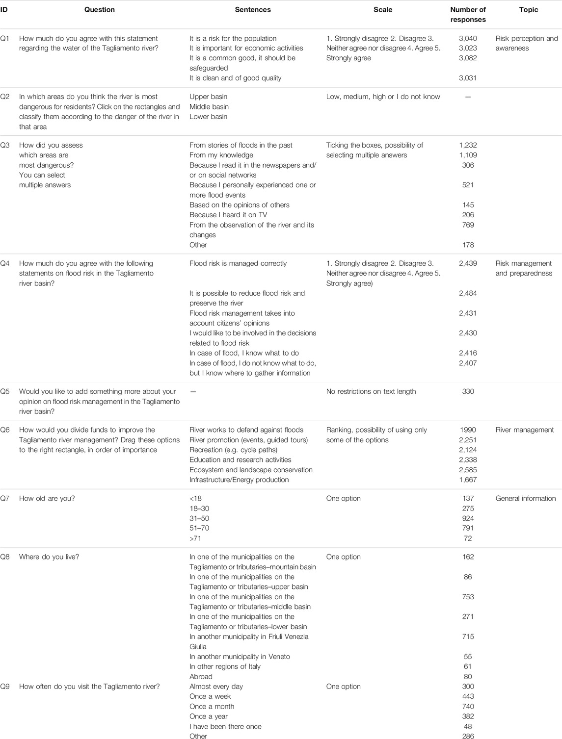
TABLE 1. The questions of the questionnaire, including question ID used throughout the article, question and sentences as formulated in the questionnaire, scale used, number of responses, and topic.
The questionnaire was available online between November 23rd, 2020 and January 5th, 2021, in Italian and English. The only condition for participation was some knowledge of the Tagliamento River, with the objective to achieve as much as possible a comprehensive picture of the different relationships, values and opinions of people. The introductory text was short and simple and explained the aim of the questionnaire. The text was intentionally kept general and did not include background information on the Tagliamento River nor on its related hazards/risks or values. The online participatory mapping questionnaire was shared with different types of stakeholders. The civil society targets were all the Friuli Venezia Giulia (FVG) municipalities and some of the Veneto municipalities, (those closer to the river), middle and high schools, public and private water managers, regional administrative offices (e.g., environmental office). Civil associations (e.g., cultural associations, NGOs), practitioners and technicians (through professional associations, e.g., engineers, geologists), official researchers and media offices of local universities were contacted. The questionnaire was also widely shared via social networks (e.g., Facebook, Twitter), local newspapers and personal contacts.
Statistical Analysis
The Pearson chi-square test of independence was used to test for differences among the participants’ responses and opinions based on their age, as well as their place of residence (Q7 and Q8). Only significant differences between the classes are discussed in the manuscript.
Free-Text Analysis
Free-text answers to question Q5 were analyzed using a hybrid manual-automated approach to identify the most frequent topics mentioned by respondents. The free-text analysis consisted of two main methods:
1) Analysis of word frequencies in the free-text: word clouds were produced based on the occurrence of words in free text, with the exception of stop-words (articles, prepositions and other unspecific recurring words). The word frequency analysis was performed in Italian and then the words occurring at least four times were translated into English. Words with the same meaning (e.g. different forms of the same verb, singular/plurals) were merged together.
2) Categorization of free-text answers into selected topics: the software QuestionPro allows to categorize free-text responses to selected topics. Each topic is identified by a list of keywords that are searched in the text. The operation can be done automatically (searching the keywords through the free-text comment) or manually. Answers can belong to multiple topics.
The categorization process was performed iteratively with the following steps:
• screening of free-text responses and identification of the main topics;
• choice of the topics based on the UN Global Assessment Report on Disaster Risk Reduction framework for Risk-informed sustainable development (UNDRR, 2019). The topics selected here were based on the results of the initial screening, the topics mentioned in the GAR framework (that include political, social, and technological components of risk management strategies), and the authors’ knowledge;
• definition of keywords for each topic based on existing frameworks, authors’ knowledge of the context and words frequently encountered in the free-text comments (identified during the initial screening). The corresponding keywords are listed in Supplementary Table S1;
• automated search of keywords for each topic and preliminary categorization of the free-text answers;
• manual review of categorized answers and categorization of the remaining ones until reaching 75–80% coverage. All the tags were revised through manual screening of the categorization.
In addition, the presence of topics related to the SENDAI and SDG frameworks in the free-text responses was analyzed (Scaini et al., 2021).
Results
Participants Statistics
Overall, 4,145 participants started and 2,220 completed the online questionnaire, corresponding to a 53.6% completion rate, across 37 different countries, with 94% of responses coming from Italy. Information on age and place of residence distribution (Istituto Nazionale Statistica, 2019) is shown in Supplementary Tables S2, S3. The 58% of the respondents are resident of the river basin, while 32% of the respondents are resident in other municipalities of FVG. The percentage of respondents from outside the FVG region was low (9%). More than 30% of participants visit the river at least once a week, and more than half of participants do so at least once a month (34% once a month, 20% once a week, 17% once a year, 14% daily, and 2% have been there once). The remaining 13% of participants who responded “Other” mentioned different frequency of visits based on different seasons, with more visits in summer than winter.
The total number of responses for each question is shown in Table 1. In order to achieve a statistical sample to perform the chi-square test, the place of residence categories for the tributaries and the upper basin, as well as the categories for municipalities not along the river (FVG, Veneto, other regions in Italy) and residents living abroad were aggregated. For the same reason, the age categories for the 51–70 and >70 were aggregated.
Flood Risk Perception
Results of Q1 on water being a factor of risk show that among respondents, approximately 30% perceived the river as a factor of risk, while 50% disagreed with this statement and 20% neither agreed nor disagreed. The extreme responses (complete agreement or disagreement) were rarely chosen. Percentages were similar in the middle and upper basins. However, percentages were quite different for respondents in the lower basin, where 55% perceived the river as a risk.
Flood risk perception maps are shown in Figure 1, displaying the percentage of respondents that associated each area with a specific level of risk. The perceived risk in the upper basin was generally lower, identified as not very dangerous by 50% of the respondents. In turn, the lower basin was identified as very dangerous by 85% of respondents. There were high percentages of I do not know, particularly for the upper basin, where almost half of the respondents (46%) selected this option.
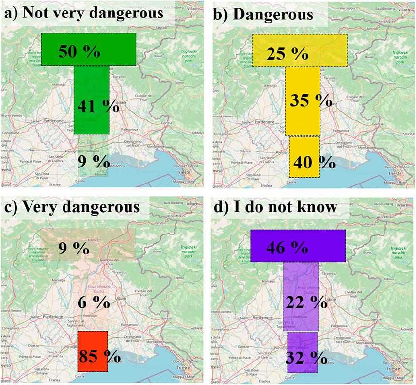
FIGURE 1. Map of perceived risk responses (Q2). For each area, the percentage of answers assigning the area to the specific level of risk is shown.
The main sources of information about flood risk (Q3) were stories of past floods (29%), personal knowledge (26%), observation of the river and its changes (18%) and personal experience of flood events (12%). Other sources of information, e.g., newspapers, social networks, TV, were selected by less than 10% of respondents.
Flood Risk and River Management
The percentage of respondents was almost even between the respondents who agreed with the current river management (33%), disagreed (35%), and selected neither option (30%). The percentages of respondents that neither agree or disagree are quite high (around 30%) for all sentences but one: all participant groups in fact agreed with the statement It is possible to reduce flood risk and preserve the river, with 88% of respondents agreeing or completely agreeing, regardless of age and place of residence (Q4, Figure 2). Most respondents were in disagreement or did not know how to respond to the statement Flood risk management takes into accounts citizens’ opinions. A majority (56%) expressed interest in decisions related to flood risk, while 30% neither agreed nor disagreed with this statement.
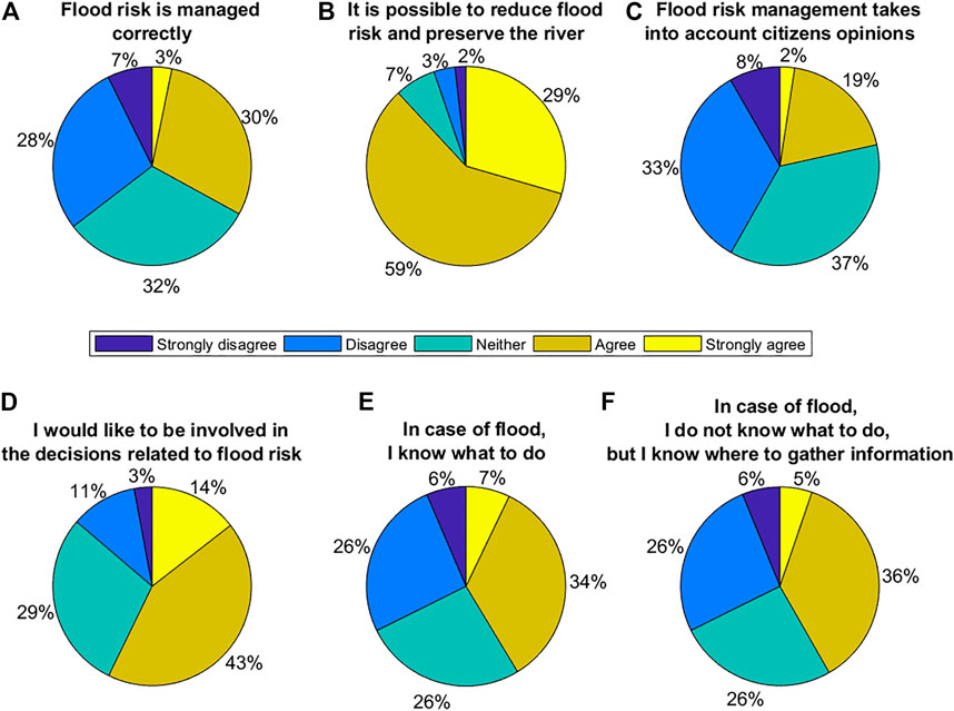
FIGURE 2. Level of agreement for Q4 (How much do you agree with the following statements on flood risk in the Tagliamento river basin?).
Most of the responses did not show a significant difference between the average responses by place of residence, but there were significant differences across age groups (Supplementary Table S4). Participants from the lower basin more often disagreed with the statements Flood risk management takes into account citizens’ opinions and Flood risk is managed correctly was lower for participants from this region. Their level of agreement was also lower for the statement In case of flood, I do not know what to do, but I know where to gather information, indicating that these participants felt less informed than in other regions. In terms of age class, the level of disagreement with the statements Flood risk management accounts for citizens’ opinion and Flood risk management takes into account citizens’ opinions was higher for older respondents than younger respondents, i.e., increased with the age of the respondents. The trend was reversed for the statement In case of flood, I know what to do, as younger respondents more often disagreed with this statement than older respondents (Supplementary Figure S1).
The free-text question, Q5, was answered by 330 respondents. The most commonly used words in the free-text responses included flood, risk and area (Figure 3A). Flood is also used to identify more technical terms, like bankfull, but the distinction might not have been clear to some of the respondents. Many helping verbs (should, could, must) were also widely used. Latisana, the most populated town in the lower basin, was often mentioned (Figure 3A).
FIGURE 3. (A) Word cloud of the free-text answer to Q5. The word cloud is based on the free-text comments, accounting for the 14% of total respondents. (B) Number of occurrences of selected keyword groups in the free-text of Q5, expressed as percentage of the total number of free-text comments.
The content of most comments was related to risk and planning (Figure 3B). Answers showed a prevalence of risk-related comments, mostly mentioning the flood risk in the lower part of the river basin. Land use planning was mentioned in 20% of the free-text responses, identifying the urbanization patterns in the lower part of the river basin as the main cause for floods. The importance of expert knowledge was mentioned in many comments (16%). Interventions were also frequently mentioned (15%), with comments related to the flood defense measures planned after the 1966 flood. River maintenance was mentioned mostly in relation to removing trees from the riverbed and gravel excavation activities. About 6% of the comments pointed out the importance of education or the role of meteorological events (including climate change, mentioned in three comments).
Risk and planning belong to the applied science sphere in the GAR. The third most commented topic was knowledge, related to natural science, and the fourth was interventions, related to applied science. Values, mentioned by 12% of respondents, included tangible and intangible contributions of the river to people’s wellbeing, are related to the human/social science spheres.
In the prioritization of river management measures (Q6), respondents ranked Ecosystem and landscape conservation as the highest priority for more than 60% of respondents, while Infrastructure and energy production was the most excluded option (Supplementary Table S5). Flood protection was ranked as the third priority. To assess if there was a difference based on age and place of residence, the mean of the ranking attributed to each option was computed as a function of the participant characteristics. There were small differences across age groups. The age class 31–50 ranked Infrastructure and energy lower than respondents from other age classes. Regarding place of residence, the average ranking was similar between groups, with the exception of respondents in the lower basin. Only 12% of the respondents residing in the middle basin identified the River works to defend from the floods as the first priority, while respondents residing in the lower basin ranked this their highest priority (i.e., it was identified as first priority by the 45% of the respondents from the lower basin). With a mean rank value slightly above three for Education and research activities, respondents from the lower basin assigned a lower priority to this management option (Supplementary Figure S3). They also assigned a slightly lower priority to Ecosystem and landscape conservation, while respondents from all the other groups selected it as the first option.
Discussion
Risk Perception in the Tagliamento River Basin
The Tagliamento River is clearly identified as a source of risk, in particular by respondents residing in the lower basin (Q1), many of whom prioritize defense against floods over other river management options (Supplementary Figure S3, particularly so for participants from the lower basin). The risk perception mapping (Q2) shows a high risk perception in the lower basin, while answers from participants of other areas show a higher level of uncertainty (Figure 1D). Respondents also identified the main factors that condition their risk perception in the Tagliamento River basin (Q3), showing that their perception is conditioned primarily by past events and river observation, secondarily by personal experience and only marginally by media (newspapers, social networks). The high relevance of knowledge and observation suggests that citizens rely on their personal knowledge, experience and from the observation of the river and its changes, in agreement with the findings of Scolobig et al. (2012), where participants indicated previous similar events as their main motive for awareness, followed by environmental signals.
To assess which areas of the Tagliamento River basin are prone to floods, the maps provided by river basin plans (PAI) are of limited use as they are based on historical floods of all rivers in the FVG region, making it impossible to assess what flooded areas are related specifically to the Tagliamento River (Supplementary Figure S4). The model-based PGRA flooded areas associated to low, medium and high return period (green, yellow and red, respectively) are used as a comparison to the flood perception of respondents (Figure 4). In the lower basin, the area affected by floods of low return period is much smaller compared to the areas affected in case of higher return period events (Figure 4B). In contrast, the middle and upper basin have almost the same flood area extent for long and short return periods (Figures 4C,D). Over the whole basin, an area of 52, 139 and 172 km2 would be flooded during events associated to the return periods of 30, 100 and 300 years, respectively, while the areas associated with high impact (i.e. occurrence of injuries, life losses, structural damages on buildings, disruption of economic and strategic activities) are much lower (3, 17 and 30 Km2, respectively) (Distretto idrografico delle Alpi Orientali, 2016). This can be explained by the fact that most of the flooded area in the lower basin is devoted to agriculture. However, there is limited information on the exposure and vulnerability datasets adopted for this analysis.
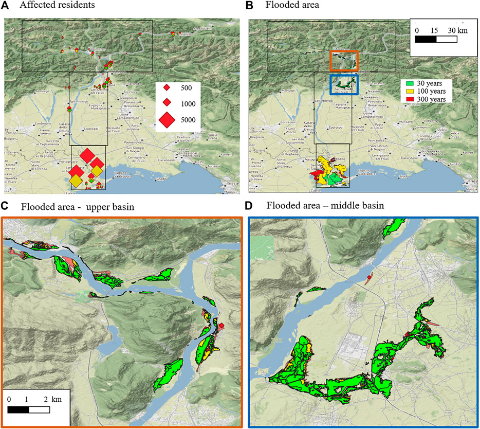
FIGURE 4. (A) PGRA map of affected residents in the areas at risk for the three return periods considered: 30 years (green), 100 years (yellow) and 300 years (red). The symbol size is proportional to the number of affected residents. The black outlines correspond to the areas used in the risk mapping question (Q2). (B) PGRA flood area map for the same three return periods. Areas flooded by higher return period events include areas flooded by lower return period floods, e.g., areas filled with green would be flooded also by higher return period, red or yellow, floods. (C) Detailed upper basin flood areas corresponding to the three return periods. (D) Detailed middle basin flood areas corresponding to the three return periods.
In the questionnaire, risk perception does not refer to a specific return period. The historical event of 1966, of an estimated return period of 100 years (Spaliviero, 2003), conditions the risk perception. It is thus likely that long-term residents had the 1966 flood in mind when they assessed flood risk. Other studies on risk awareness observed higher awareness of extreme events, associated with low probability and high impact, and less perception of risk from frequent events (Gonzalez and Wu, 1999; Robinson and Botzen, 2020). Our results confirm this, showing a high risk perception in the lower basin, while risk perception in mountain areas, characterized by frequent floods with a lower return period, is lower, and associated with high uncertainties.
The PRGA technical document acknowledges the uncertainties related to the assessment of rainfall patterns, solid transport and estimated discharge for the given return periods, and the challenges related to the monitoring and collection of hydrological data (Distretto idrografico delle Alpi Orientali, 2016). Current hazard and risk assessments are based on data primarily based on the 1966 event, and should be generalized in order to define realistic scenarios that account for different aspects (e.g. changes in land use, modification of levees, climate-change impact on precipitation patterns). Thus, efforts should be devoted to improving current flood hazard and risk assessments in order to tackle these aspects making use of recent, higher-quality data. The last decades have seen substantial efforts to assess and reduce risk at the local scale both in the upper basin (and tributaries, e.g., Chen et al., 2016) and in the lower basin. However, in order to increase their benefit to the river communities, these efforts should be integrated into a full-basin perspective and merged with other aspects of river management (e.g. land use planning, river conservation, socio-economic activities).
Successful river management should effectively combine protection from extreme events and ecosystem conservation, while integrating the social perception of flood risk (Bodoque et al., 2016). The respondents’ answers point to a strong relation between risk perception and conservation values to the river and suggest that there is a willingness to implement these relatively recent strategies. To achieve both risk reduction and river conservation, residents may be prone to support renaturation measures such as nature-based solutions (Hartmann et al., 2019; Santoro et al., 2019). Although the respondents had a divided opinion on the current risk management in the Tagliamento River basin (Figure 2), most show a clear willingness to reduce risk and preserve the current status of the river: 88% of respondents were in agreement with the sentence It is possible to reduce flood risk and preserve the river (Q4), independently of their place of residence and age, suggesting that citizens consider that both are important.
The importance given to conservation may be partly related to a self-selection bias (Brown et al., 2012), where people with a strong attachment to the Tagliamento River may have been more likely to participate in the questionnaire. Moreover, the questionnaire was only accessible online and for 43 days, which might have limited the number and range of responses. However, the large number of respondents, the free-text analysis word cloud and the tag-based analysis show that people across different age, places of residence and frequency of visits groups value the river. Participants also mention land use planning and other issues that are recognized as relevant in the debate on flood risk management, indicating a high level of awareness.
The respondents’ expressed preference for combining risk reduction and conservation is not reflected in the current flood risk management measures. After the 1966 flood and particularly over the last 20 years, a number of flood defense infrastructural measures have been proposed, and a debate remains open about additional measures in the middle and upper basins. In contrast to a study in Swiss catchments, where local governments in areas of high flood risk perception tend to prefer non-structural measures (spatial planning and ecological river restoration, i.e. “green infrastructure”) (Glaus et al., 2020), the planners on the Tagliamento River seem to prioritize “grey infrastructure” measures for risk reduction (van der Nat et al., 2002; Toniutti and Ludovici, 2002; Reggiani, 2005; Commissione regionale Laboratorio Tagliamento, 2011).
Citizen Participation and Risk-Informed Sustainable Development
Citizens play a key role in modern flood risk management frameworks: they should be considered as active players that can contribute to the societal response during disasters (UNISDR, 2017). Although public participation at all stages of risk management is required in Italian legislation, the level of involvement is low (Wehn et al., 2015). In this context, the questionnaire presented in this study can serve as a basis for improving public participation by providing a better understanding of people’s perception of risk, their preparedness, and potential mismatches between citizens’ priorities and current risk management practices.
In order to react effectively, citizens need to be informed and trained. The risk preparedness questions (Q4) obtained uncertain responses: 40% know what to do in case of a flood event, or, if they do not know what to do, they know where to find information, but more than 30% do not know what to do, and approximately 25% answered Neither (Figure 2). These results show that, despite the high level of preparedness usually found in Alpine regions (Scolobig et al., 2012), citizens’ feeling of preparedness is not very high. In particular, residents in the lower basin show less agreement with the preparedness sentences compared to upper and middle basin (Supplementary Figure S1), which suggests that they might feel less prepared to future flooding. While (Scolobig et al., 2012) surveyed a small area where many training activities are carried out periodically, the area surveyed here is larger (the Tagliamento River basin is 2,871 km2) and not all the population lives in flood-prone areas and/or is periodically trained. However, even answers from respondents residing in flood-prone areas (lower basin) show similar results.
Answers to the questions related to risk management (Q4 and Q5) demonstrate some degree of knowledge of the river and its processes, as well as an interest in receiving more information and being involved in risk management procedures (55% agreed or strongly agreed to the I would like to be involved in the decisions related to flood risk statement). However, the high percentage (25–30%) of the neither answer suggests the need for better information, training and communication strategies to inform citizens. Both PAI and PRGA maps and technical documents are available online, and 99% of the municipalities of the Friuli Venezia Giulia region, including all the ones that belong in the Tagliamento River basin, have emergency plans. Preparedness might be improved through risk communication (Lechowska, 2018), and by actively involving citizens in all stages of flood management, from preparation and monitoring to mitigation (Wehn et al., 2015).
The PGRA technical document mentions citizen participation, in particular in relation to crowd-sourcing for better river monitoring. In addition, there are participatory mechanisms that allow citizens to be informed about current risk management strategies and submit their comments and observations. However, participation mechanisms are not always perceived as effective: the sentence Flood risk management takes into account citizens’ opinion had very equally distributed answers, casting doubt that citizens' opinions are taken into account in the river management process. This feeling is even stronger for participants from the lower basin and with age. This should be addressed, since the limited participation of citizens in decisions related to flood risk is likely to lead to conflict and frustration (Begg et al., 2018).
The free-text responses provide additional information on the respondents’ interests, concerns and opinions. Despite the high specificity of the question, focused on flood risk management, a number of other topics were widely mentioned by respondents, including land use planning and conservation. The free-text responses (Q5) in relation to the GAR risk-informed sustainable development, SDGs and SENDAI frameworks can serve as a basis for future disaster risk reduction and river management actions and priorities in the study area, particularly a move towards an ecosystem-based approach to disaster risk reduction, as called upon (Briceño, 2015; Faivre et al., 2018). The comparison of most-mentioned topics with the GAR report (Figure 3B) shows that all the topics identified in the free-text analysis are comprised in human/social science, applied science, and general spheres of the GAR. In the GAR framework, there is only one explicit reference to communication from the technical point of view, under design science. However, our free-text analysis shows the high relevance of the social component of risk communication, which does not fit in easily in the framework.
The work of Scaini et al. (2021) analyzed the presence of SENDAI and SDG topics in academic and local newspaper articles. They found that SDG6 is widely covered by academic articles, while SDG12, SENDAI1, SENDAI4, SENDAId are covered by newspapers, with a strong emphasis on safety and risk-reduction topics, and less attention is given to river evolution and how this affects the expected flood hazard. Applying the same search to our free-text results, the most mentioned tags are SDG6, followed by SDG11, SENDAI1 and SENDAI2 (Supplementary Figure S2), similar to the topics addressed by academics in Scaini et al. (2021). Questionnaire respondents referred to topics that are addressed by academics but not the local newspapers, indicating a missing link between academic research and information sources.
Outlook
Our study demonstrates how online questionnaires and participatory mapping can be used to improve the understanding of citizens’ perceptions and expectations with regards to flood risk and its management. In particular, the questionnaire presented here allows mapping of risk perception and its spatial distribution across the entire river basin, making it comparable with available official hazard and risk maps. Since people's decisions are not exclusively driven by official risk maps, but also reflect their perception of risk, such studies are relevant for future risk management strategies in flood-prone areas. The answers to the questionnaire provide a picture of citizens’ risk perception and their opinion on topics that are directly and indirectly related to it (e.g. education, land use planning, ecology), but that are important factors for risk-informed sustainable development. Participatory methods, including interactive tools for risk mapping, could use this type of information as a starting point and promote the effective dissemination of wide and comprehensive risk-related knowledge to citizens. Such an integrative risk management approach will require the active cooperation of natural scientists, social scientists, and emergency management agencies (Klijn and Schweckendiek, 2012).
In the case of the Tagliamento River, where past flood events are well documented and simulations of flood risks are available, the questionnaire is primarily important to understand citizens’ perception of risk and identify mismatches between people’s priorities and current management. The questionnaire is meant as a starting point to build awareness. In particular, participated discussions are devoted to sharing the results obtained through the questionnaire, as well as the development of participatory and sustainable river management scenarios for the Tagliamento River. Such initiatives could support collaborative modelling and flood adaptation strategies (Petrov et al., 2005; Minucci et al., 2020; Sanders et al., 2020). Future management scenarios are likely to include nature-based solutions to mitigate flood risk, support conservation and provide other benefits to local inhabitants (Estrella and Saalismaa 2015). Conflicts of values may emerge given that different stakeholders are likely to hold different perspectives about how to manage flood risk (Santoro et al., 2019). In order to investigate the ambiguity in stakeholders’ perspectives in more depth and build a common understanding of the system, participatory modelling tools such as fuzzy cognitive mapping (Santoro et al., 2019) or Bayesian Networks (Salliou et al., 2017; Pham et al., 2021) would be useful. In terms of flood risk research, this work underlines the need to define flooding scenarios and assessment of their expected impacts (on population, buildings and other exposed assets) based on reliable exposure and vulnerability databases—currently missing or not specifically described in the existing risk assessment analysis despite its primary importance for flood risk mitigation.
In data-scarce regions participatory mapping can also serve as a useful information for scientists and planners (Fagerholm et al., 2012; Pandeya et al., 2016). The questionnaire was designed in collaboration with two NGOs working on water accessibility and the right to water (International Volunteering Centre, CEVI, based in Italy) and the conservation of free-flowing rivers (River Collective, based in Austria) to ensure transferability and relevance for other rivers, particularly for low-income countries. These are often characterized by low-impacted rivers and data scarcity, where participatory mapping can be an important source of information on flood risk. The use of such tools can also foster the participation of different branches of society, e.g. involving younger citizens’ by means of mobile apps and social media, or using serious games targeted at stakeholder groups (Fleming et al., 2020).
Conclusion
We present a questionnaire that explores risk perception awareness and preparedness and collects opinions on flood risk management. The questionnaire has proved effective in showing a picture of the respondent’s opinions on risk-related topics. It allows for identifying the knowledge gaps and the uncertainties of the population, in particular in relation to risk awareness and preparedness, and provides a starting point to design better information strategies and participatory approaches. In particular, the scientific and academic community has a very important role in the participatory process, and should engage with citizens and promote the dissemination of scientific concepts that contribute to building risk-informed societies.
The main results on the Tagliamento River basin, one of the last free-flowing rivers in Europe, are summarized below:
• A flood risk perception map is generated for the whole Tagliamento River basin. Perceived risk is in good agreement with existing hazard and risk assessments in areas where major floods happened (i.e. the lower basin) while in the upper basin, despite having suffered frequent floods, risk perception is scattered and more uncertain. This points to the respondents being more aware of extreme events with low probability and high impact, while their perception of risk from frequent events, i.e., with a lower return period, is lower and associated with higher uncertainties.
• The population is interested in being involved to the risk management debate, primarily related to the river flood management after the 1966 flood.
• A strong relationship between land use planning and flood risk is highlighted by respondents: land use planning is identified as a factor that can increase flood risk. Risk management and land use planning should be tackled together in order to develop risk-oriented river management and land use strategies.
• Conservation of the river is important to citizens. In particular, respondents believe that risk reduction and river conservation are compatible and should be both pursued. Flood protection measures should, to the greatest possible extent, comply with ecosystem and landscape conservation, identified as a priority by most respondents, and research should be conducted to assess feasibility, expected impacts and/or benefits of management solutions accounting for both disaster risk reduction and river conservation, including nature-based solutions.
This research provides evidence that specific questionnaires focused on risk perception, awareness and other risk management issues are effective in collecting citizens’ opinion and could serve as a tool to improve current flood risk management strategies. Based on the responses gathered from the case study presented here, applying this questionnaire to other rivers would shed light on current knowledge of citizens and involve them as active participants of flood risk management.
Data Availability Statement
The raw data supporting the conclusion of this article will be made available by the authors, without undue reservation.
Ethics Statement
Ethical review and approval was not required for the study on human participants in accordance with the local legislation and institutional requirements. Written informed consent for participation was not required for this study in accordance with the national legislation and the institutional requirements.
Author Contributions
ASc: Conceptualization, Data curation, Methodology development, Visualization, Writing–Original draft preparation. ASt: Methodology validation, Writing–reviewing and editing. CB: Methodology validation, Visualization, Writing–reviewing and editing. CS: Conceptualization, Methodology development, Visualization, Writing–reviewing and editing.
Funding
AS acknowledge support from the Swedish Research Agencies Vetenskapsrådet/Formas/Sida 2016-06313 and Formas 2018-02321. CS acknowledges the support of the National Institute of Oceanography and Applied Geophysics (OGS, Italy). Stockholm University supports open access publishing by covering article-processing charges.
Conflict of Interest
The authors declare that the research was conducted in the absence of any commercial or financial relationships that could be construed as a potential conflict of interest.
Acknowledgments
We thank all the participants and those who helped us share the questionnaire. We are thankful to Stefania Garlatti-Costa, Jay Frentress, Vera Knook and Marco Iob for their constructive comments during the preparation of the questionnaire. We thank Gabriele Peressi from the Friuli Venezia-Giulia Civil Protection for his useful suggestions, and James Fernandes for his support with QuestionPro. We thank the reviewers and the editor for their constructive comments.
Supplementary Material
The Supplementary Material for this article can be found online at: https://www.frontiersin.org/articles/10.3389/feart.2021.675131/full#supplementary-material
References
Afshar, A., Jalali, M. R., Ghoreishi, S. M., and Saed, B. (2016). Agent-based Models as a Strategy for Water Resources Management with Sustainable Development Perspective. J. Appl. Environ. Biol. Sci. 6, 208–212.
Allen, C., Metternicht, G., and Wiedmann, T. (2019). Prioritising SDG Targets: Assessing Baselines, Gaps and Interlinkages. Sustain. Sci. 14, 421–43810. doi:10.07/s11625-018-0596-8
Arias-Arévalo, P., Martín-López, B., and Gómez-Baggethun, E. (2017). Exploring Intrinsic, Instrumental, and Relational Values for Sustainable Management of Social-Ecological Systems. E&S 22, 43. doi:10.5751/ES-09812-220443
Begg, C., Callsen, I., Kuhlicke, C., and Kelman, I. (2018). The Role of Local Stakeholder Participation in Flood Defence Decisions in the United Kingdom and Germany. J. Flood Risk Manag. 11, 180–19010. doi:10.1111/jfr3.12305
Belletti, B., Garcia de Leaniz, C., Jones, J., Bizzi, S., Börger, L., Segura, G., et al. (2020). More Than One Million Barriers Fragment Europe's Rivers Nature 588 436–441. doi:10.1038/s41586-020-3005-2
Berry, L. H., Koski, J., Verkuijl, C., Strambo, C., and Piggot, G. (2019). Making Space: How Public Participation Shapes Environmental. Seattle, WA.
Bertola, M., Viglione, A., Lun, D., Hall, J., and Blöschl, G. (2020). Flood Trends in Europe: Are Changes in Small and Big Floods Different? Hydrol. Earth Syst. Sci. 24, 1805–182210. doi:10.5194/hess-24-1805-2020
Blöschl, G., Kiss, A., Viglione, A., Barriendos, M., Böhm, O., Brázdil, R., et al. (2020). Current European Flood-Rich Period Exceptional Compared with Past 500 Years Nature 583 560–566. doi:10.1038/s41586-020-2478-3
Blöschl, G., Hall, J., Viglione, A., Perdigão, R. A. P., Parajka, J., Merz, B., et al. (2019). Changing Climate Both Increases and Decreases European River Floods. Nature 573, 108–111. doi:10.1038/s41586-019-1495-6
Bodoque, J. M., Amérigo, M., Díez-Herrero, A., García, J. A., Cortés, B., Ballesteros-Cánovas, J. A., et al. (2016). Improvement of Resilience of Urban Areas by Integrating Social Perception in Flash-Flood Risk Management J. Hydrol. 541 665–676. doi:10.1016/j.jhydrol.2016.02.005
Briceño, S. (2015). Looking Back and beyond Sendai: 25 Years of International Policy Experience on Disaster Risk Reduction. Int. J. Disaster Risk Sci. 6, 1–7. doi:10.1007/s13753-015-0040-y
Brown, G., Weber, D., Zanon, D., and de Bie, K. (2012). Evaluation of an Online (Opt-in) Panel for Public Participation Geographic Information Systems Surveys. Int. J. Public Opin. Res. 24, 534–545. doi:10.1093/ijpor/eds001
Brusarosco, A., Rossato, S., and Ziliani, L. (2010). Conflitti d’ acqua e di uomini nel bacino del Tagliamento: l’utilità di un approccio integrato tra geografia umana e fisica. Quad. Del. Dottorato 4, 193–212.
Buchecker, M., Salvini, G., Baldassarre, G. Di., Semenzin, E., Maidl, E., and Marcomini, A. (2013). The Role of Risk Perception in Making Flood Risk Management More Effective, Nat. Hazards Earth Syst. Sci., 13, 3013–3030. doi:10.5194/nhess-13-3013-2013
Bustillos Ardaya, A., Evers, M., and Ribbe, L. (2019). Participatory Approaches for Disaster Risk Governance? Exploring Participatory Mechanisms and Mapping to Close the Communication gap between Population Living in Flood Risk Areas and Authorities in Nova Friburgo Municipality, RJ, Brazil, Land Use Policy, 88, 104103. doi:10.1016/j.landusepol.2019.104103
Chen, L., van Westen, C. J., Hussin, H., Ciurean, R. L., Turkington, T., Chavarro-rincon, D., et al. (2016). Integrating Expert Opinion with Modelling for Quantitative Multi-hazard Risk Assessment in the Eastern Italian Alps, Geomorphology, 273, 150–167. doi:10.1016/j.geomorph.2016.07.041
Dilling, L., and Lemos, M. C. (2011). Creating Usable Science: Opportunities and Constraints for Climate Knowledge Use and Their Implications for Science Policy. Glob. Environ. Change 21 680–689. doi:10.1016/j.gloenvcha.2010.11.006
Distretto idrografico delle Alpi Orientali (2016). Piano di Gestione del Rischio Alluvioni. Flood Risk Management Plan.
Dogaru, D., Zobrist, J., Balteanu, D., Popescu, C., SimaM, M., and Amini, M. (2009). Community Perception of Water Quality in a Mining-Affected Area: A Case Study for the Certej Catchment in the Apuseni Mountains in Romania. Environ. Manage. 43, 1131–1145. doi:10.1007/s00267-008-9245-9
Elmer, F., Hoymann, J., Duthmann, D., Vorogushyn, S., and Kreibich, H. (2012). Drivers of Flood Risk Change in Residential Areas. Nat. Hazards Earth Syst. Sci. 12, 1641–1657. doi:10.5194/nhess-12-1641-2012.
Estrella, M., and Saalismaa, N. (2015). The Role of Ecosystems in Disaster Risk Reduction Vol 13. doi:10.1016/j.ijdrr.2015.08.001
European Commission (2007). Directive 2007/60/EC of the European Council and European Parliament of 23 October 2007 on the Assessment and Management of Flood Risks, Strasbourg, France: European UnionOnline: http://eur-lex.europa.eu/legal-content/EN/TXT/PDF/?uri=CELEX:32007L0060&from=EN.
European Environment Agency (2020). Tracking Barriers and Their Impacts on European River Ecosystems, Copenhagen, Denmark: European Environment Agency: European Union.
Evers, M., Jonoski, A., Almoradie, A., and Lange, L. (2016). Collaborative Decision Making in Sustainable Flood Risk Management: A Socio-Technical Approach and Tools for Participatory Governance Environ. Sci. Pol. 55, 335–344. doi:10.1016/j.envsci.2015.09.009
Fagerholm, N., Käyhkö, N., Ndumbaro, F., and Khamis, M. (2012). Community Stakeholders ’ Knowledge in Landscape Assessments – Mapping Indicators for Landscape Services Ecol. Indic 18, 421–433. doi:10.1016/j.ecolind.2011.12.004
Fagerholm, N., Raymond, C. M., Olafsson, A. S., Rinne, T., Hasanzadeh, K., Broberg, A., et al. (2021). A Methodological Framework for Analysis of Participatory Mapping Data in Research, Planning , and Management. Int. J. Geogr. Inf. Sci. 00, 1–28. doi:10.1080/13658816.2020.1869747
Faivre, N., Sgobbi, A., Happaerts, S., Raynal, J., and Schmidt, L. (2018). Translating the Sendai Framework into Action: The EU Approach to Ecosystem-Based Disaster Risk Reduction. Int. J. Disaster Risk Reduct 32, 4–10. doi:10.1016/j.ijdrr.2017.12.015
Feldman, D., Contreras, S., Karlin, B., Basolo, V., Matthew, R., Sanders, B., et al. (2016). International Journal of Disaster Risk Reduction Communicating Fl Ood Risk: Looking Back and Forward at Traditional and Social media Outlets Int. J. Disaster Risk Reduct. 15 43–51. doi:10.1016/j.ijdrr.2015.12.004
Fleming, K., Abad, J., Booth, L., Schueller, L., Baills, A., Scolobig, A., et al. (2020). The Use of Serious Games in Engaging Stakeholders for Disaster Risk Reduction, Management and Climate Change Adaption Information Elicitation. Int. J. Disaster Risk Reduct 49. doi:10.1016/j.ijdrr.2020.101669
Glaus, A., Mosimann, M., Röthlisberger, V., and Ingold, K. (2020). How Flood Risks Shape Policies: Flood Exposure and Risk Perception in Swiss Municipalities Reg. Environ. Chang. 20. 120. doi:10.1007/s10113-020-01705-7
Global Water Partnership, United Nations and Australian Aid (2016). Water Security and the Sustainable Development Goald (SDGs) High Level Round Table 36 Online:, Yangon, Myanmar: Global Water Partnership. http://www.gwp.org/contentassets/985bec2240b845c6ae9ea08446fcbd22/myanmar---high-level-round-table-final-report.pdf.
Gonzalez, R., and Wu, G. (1999). On the Shape of the Probability Weighting Function. Cogn. Psychol. 38, 129–166. doi:10.1006/cogp.1998.0710
Gregg, C. E., Houghton, B. F., Paton, D., Lachman, R., Lachman, J., Johnston, D. M., et al. (2006). Natural Warning Signs of Tsunamis: Human Sensory Experience and Response to the 2004 Great Sumatra Earthquake and Tsunami in Thailand. Earthq. Spectra 22, 671–691. doi:10.1193/1.2206791
Grill, G., Lehner, B., Thieme, M., Geenen, B., Tickner, D., Antonelli, F., et al. (2019). Mapping the World’s Free-Flowing Rivers. Nature 569, 215–221. doi:10.1038/s41586-019-1111-9
Grizzetti, B., Liquete, C., Pistocchi, A., Vigiak, O., Zulian, G., Bouraoui, F., et al. (2019). Relationship between Ecological Condition and Ecosystem Services in European Rivers, Lakes and Coastal Waters. Sci. Total Environ. 671, 452–465. doi:10.1016/j.scitotenv.2019.03.155
Hartmann, T., Slavíková, L., and McCarthy, S. (2019). Nature-Based Solutions in Flood Risk Management, Cham, Switzerland: SpringerOpen.
Haworth, B. T., Bruce, E., Whittaker, J., and Read, R. (2018). The Good, the Bad, and the Uncertain: Contributions of Volunteered Geographic Information to Community Disaster Resilience Front. Earth Sci. 6, 1–15. doi:10.3389/feart.2018.00183
Istituto Nazionale Statistica (2019). Censimento permanente della popolazione e delle abitazioni, Rome, Italy: Istituto nazionale di statisticaOnline: https://www.istat.it/it/censimenti/popolazione-e-abitazioni.
Klijn, F., and Schweckendiek, T. (2012). Comprehensive Flood Risk Management Research for Policy and Practice. London: Taylor & Francis Group.
Klonner, C., Usón, T. J., Aeschbach, N., and Höfle, B. (2021). Participatory Mapping and Visualization of Local Knowledge: An Example from Eberbach, Germany. Int. J. Disaster Risk Sci. 12, 56–71. doi:10.1007/s13753-020-00312-8
Lang, D. J., Wiek, A., Bergmann, M., Stauffacher, M., Martens, P., Moll, P., et al. (2012). Transdisciplinary Research in Sustainability Science: Practice, Principles, and Challenges. Sustain. Sci. 7, 25–43. doi:10.1007/s11625-011-0149-x
Lechowska, E. (2018). What Determines Flood Risk Perception? A Review of Factors of Flood Risk Perception and Relations between its Basic Elements. Nat. Hazards 94, 1341–1366. doi:10.1007/s11069-018-3480-z
Liguori, A., Mcewen, L., Blake, J., and Wilson, M. (2021). Towards ‘Creative Participatory Science’: Exploring Future Scenarios through Specialist Drought Science and Community Storytelling, Front. Environ. Sci., 8, 1–17. doi:10.3389/fenvs.2020.589856
Maidl, E., and Buchecker, M. (2015). Raising Risk Preparedness by Flood Risk Communication. Nat. Hazards Earth Syst. Sci. 15, 1577–1595. doi:10.5194/nhess-15-1577-2015
Minucci, G., Molinari, D., Gemini, G., and Pezzoli, S. (2020). Enhancing Flood Risk Maps by a Participatory and Collaborative Design Process. Int. J. Disaster Risk Reduct. 50, 101747. doi:10.1016/j.ijdrr.2020.101747
Mondino, E., Scolobig, A., Borga, M., Albrecht, F., Mård, J., Weyrich, P., et al. (2020). Exploring Changes in Hydrogeological Risk Awareness and Preparedness over Time: a Case Study in Northeastern Italy Hydrol. Sci. J. 65, 1049–1059. doi:10.1080/02626667.2020.1729361
Moraine, M., Grimaldi, J., Murgue, C., Duru, M., and Therond, O. (2016). Co-design and Assessment of Cropping Systems for Developing Crop-Livestock Integration at the Territory Level, Agric. Syst., 147, 87–97. doi:10.1016/j.agsy.2016.06.002
Mould, S. A., Fryirs, K. A., and Howitt, R. (2020). The Importance of Relational Values in River Management: Understanding Enablers and Barriers for Effective Participation Ecol. Soc 25, 1–16. doi:10.5751/es-11505-250217
Osti, G. (2019). Prove socio-tecniche di sicurezza idraulica: il caso del fiume Tagliamento. Quaderni di etica applicata - Ambiente, 127.
Pandeya, B., Buytaert, W., Zulka, Z., Karpouzoglou, T., Mao, F., and Hannah, D. M. (2016). A Comparative Analysis of Ecosystem Services Valuation Approaches for Application at the Local Scale and in Data Scarce Regions, Ecosystem Serv., 22, 250–259. doi:10.1016/j.ecoser.2016.10.015
Paronuzzi, P. (2005). in Le Acque Il Tagliamento. Editors Z. A. F. Bianco, A. Bondesan, P. Paronuzzi, and M. Zanetti (Sommacampagna (VR): CIERRE Edizioni), 165–207.
Peng, L., Tan, J., Lin, L., and Xu, D. (2019). Understanding Sustainable Disaster Mitigation of Stakeholder Engagement: Risk Perception, Trust in Public Institutions, and Disaster Insurance Sustain. Dev 27, 885–897. doi:10.1002/sd.1948
Petrov, L. O., Barredo, J. I., Lavalle, C., Sagris, V., De Roo, A., Gierk, M., et al. (2005). Adaptation Strategies for Flood Mitigation in the Urban Environment: The Case Study. Italy: Friuli-Venezia Giulia (FVG).
Pham, H. V., Sperotto, A., Furlan, E., Torresan, S., Marcomini, A., and Critto, A. (2021). Integrating Bayesian Networks into Ecosystem Services Assessment to Support Water Management at the River basin Scale. Ecosyst. Serv. 50, 101300. doi:10.1016/j.ecoser.2021.101300
Reggiani, P. (2005). Simulazione matematica della transizione di un ’ onda di piena centennale sul medio e basso Tagliamento.
Rizzetto, F. (2020). in Climate Change, Hazards and Adaptation Options. Handling the Impacts of a Changing Climate. Editors W. L. Filho, G. J. Nagy, M. Borga, P. D. C. Muñoz, and A. Magnuszewski (Springer).
Robinson, P. J., and Botzen, W. J. W. (2020). Flood Insurance Demand and Probability Weighting: The Influences of Regret, Worry, Locus of Control and the Threshold of Concern Heuristic Water Resour. Econ 30, 100144. doi:10.1016/j.wre.2019.100144
Rusca, M., Messori, G., and Di Baldassarre, G. (2021). Scenarios of Human Responses to Unprecedented Social‐environmental Extreme Events. Earth’s Futur 9, 1–20. doi:10.1029/2020ef001911
Salliou, N., Barnaud, C., Vialatte, A., and Monteil, C. (2017). A Participatory Bayesian Belief Network Approach to Explore Ambiguity Among Stakeholders about Socio-Ecological Systems. Environ. Model. Softw. 96, 199–209. doi:10.1016/j.envsoft.2017.06.050
Sanders, B. F., Schubert, J. E., Goodrich, K. A., Houston, D., Feldman, D. L., Basolo, V., et al. (2020). Collaborative Modeling with Fine-Resolution Data Enhances Flood Awareness, Minimizes Differences in Flood Perception, and Produces Actionable Flood Maps. Earth’s Futur 8, 1–23. doi:10.1029/2019ef001391
Santoro, S., Pluchinotta, I., Pagano, A., Pengal, P., and Giordano, R. (2019). Assessing Stakeholders’ Risk Perception to Promote Nature Based Solutions as Flood protection Strategies: The Case of the Glin Šč Ica River (Slovenia) Sci. Total Environ. 655, 188–201. doi:10.1016/j.scitotenv.2018.11.116
Scaini, A., Scaini, C., Frentress, J., Destouni, G., and Manzoni, S. (2021). Linking the 2030 Agenda for Sustainable Development to Governance: The Case of the Last Free-Flowing Alpine River Front. Environ. Sci. 9, 1–15. doi:10.3389/fenvs.2021.553822
Scolobig, A., Marchi, B. De., and Borga, M. (2012). The Missing Link between Flood Risk Awareness and Preparedness: Findings from Case Studies in an Alpine. Nat. Hazards 63, 499–520. doi:10.1007/s11069-012-0161-1
Scolobig, A., and Pelling, M. (2016). The Co-production of Risk from a Natural Hazards Perspective: Science and Policy Interaction for Landslide Risk Management in Italy. Nat. Hazards 81, 7–25. doi:10.1007/s11069-015-1702-1
Seher, W., and Löschner, L. (2018). Balancing Upstream – Downstream Interests in Flood Risk Management: Experiences from a Catchment-Based Approach in Austria. J. Flood Risk Manag. 11, 56–65. doi:10.1111/jfr3.12266
Spaliviero, M. (2003). Historic Fluvial Development of the Alpine-foreland Tagliamento River, Italy, and Consequences for Floodplain Management. Geomorphology 52, 317–333. doi:10.1016/s0169-555x(02)00264-7
Strassburg, B. B. N., Iribarrem, A., and Beyer, H. L. (2020). Global Priority Areas for Ecosystem Restoration, Nature, 586, 724–729. doi:10.1038/s41586-020-2784-9
Tickner, D., Parker, H., Moncrieff, C. R., Oates, N. E. M., Ludi, E., Acreman, M., et al. (2017). Managing Rivers for Multiple Benefits – A Coherent Approach to Research, Policy and Planning, Front. Environ. Sci., 5, 1–8. doi:10.3389/fenvs.2017.00004
Tockner, K., Ward., J. V., Arscott, D. B., Edwards, P. J., Kollmann, J., Gurnell, A. M., et al. (2003). The Tagliamento River: A Model Ecosystem of European Importance. Aquat. Sci. 65, 239–253. doi:10.1007/s00027-003-0699-9
Toniutti, N., and Ludovici, A. A. (2002). Tagliamento fiume d’Europa - il problema delle casse di espansione. Rome: WWF Italy.
Trigila, A., and Iadanza, C. (2018). Landslides and Floods in Italy: hazard and Risk Indicators Vol 287. Rome: bis/20. Online: www.isprambiente.gov.it.
UNISDR (2017). The Sendai Seven Campaign - 7 Targets, 7 Years (2016-2022), Geneva, Switzerland: United Nations office for Disaster Risk ReductionOnline: https://www.preventionweb.net/files/54917_iddr2017conceptnote.pdf.
UNDRR (2019). Global Assessment Report on Disaster Risk Reduction. Geneva, Switzerland. Online: https://gar.undrr.org/.
UNECE (1998). Convention On Access to Information, Public Participation in Decision-Making and Access to justice in Environmental Matters. Aarhus, Denmark: Aarhus Convention.
van der Nat, D., Schmidt, A. P., Tockner, K., Edwards, P. J., and Ward, J. V. (2002). Inundation Dynamics in Braided Floodplains: Tagliamento River, Northeast Italy. Ecosystems 5, 636–647.
Ward, J. V., Tockner, K., Edwards, P. J., Kollmann, J., Bretschko, G., Gurnell, A. M., et al. (1999). A Reference River System for the Alps: The “Fiume Tagliamento”. Regul. Rivers Res. Manag. 15, 63–75. doi:10.1002/(sici)1099-1646(199901/06)15:1/3<63::aid-rrr538>3.0.co;2-f
Keywords: participation, flood risk management, participatory mapping, questionnaire, river conservation, local knowledge, risk perception, Tagliamento river
Citation: Scaini A, Stritih A, Brouillet C and Scaini C (2021) Flood Risk and River Conservation: Mapping Citizen Perception to Support Sustainable River Management. Front. Earth Sci. 9:675131. doi: 10.3389/feart.2021.675131
Received: 02 March 2021; Accepted: 11 June 2021;
Published: 24 June 2021.
Edited by:
Umberto Fratino, Politecnico di Bari, ItalyReviewed by:
Qi Yao, China Earthquake Administration, ChinaAlessandro Pagano, Istituto di Ricerca Sulle Acque IRSA-CNR, Italy
Copyright © 2021 Scaini, Stritih, Brouillet and Scaini. This is an open-access article distributed under the terms of the Creative Commons Attribution License (CC BY). The use, distribution or reproduction in other forums is permitted, provided the original author(s) and the copyright owner(s) are credited and that the original publication in this journal is cited, in accordance with accepted academic practice. No use, distribution or reproduction is permitted which does not comply with these terms.
*Correspondence: Anna Scaini, YW5uYS5zY2FpbmlAbmF0Z2VvLnN1LnNl