 David Max Findley1*
 Greg Bankoff2†Grace Barretto-Tesoro3†
 Rebecca Hamilton1†Andrea U. Kay1†
 Stephen Acabado2†‡
 Noel Amano1†‡
 Jed O. Kaplan5†‡
 Patrick Roberts1,3,6*‡
- 1Department of Archeology, Max Planck Institute for the Science of Human History, Jena, Germany
- 2Department of History, Ateneo de Manila University, Quezon City, Philippines
- 3Archaeological Studies Program, University of the Philippines, Quezon City, Philippines
- 4Department of Anthropology, University of California, Los Angeles, Los Angeles, CA, United States
- 5Department of Earth Sciences, The University of Hong Kong, Hong Kong, Hong Kong SAR, China
- 6School of Social Sciences, University of Queensland, Brisbane, QLD, Australia
Land use modelling is increasingly used by archaeologists and palaeoecologists seeking to quantify and compare the changing influence of humans on the environment. In Southeast Asia, the intensification of rice agriculture and the arrival of European colonizers have both been seen as major catalysts for deforestation, soil erosion, and biodiversity change. Here we consider the Tuwali-Ifugao people of the Cordillera Central (Luzon, Philippines), who resisted Spanish colonial subjugation from the 16th to the mid-nineteenth century, in part through the development of a world-renowned system of intensive wet-rice terrace agriculture. To quantify changes in how the Tuwali-Ifugao used their environment, we model land use in Old Kiyyangan Village, a long-inhabited settlement, at two timepoints: circa 1570 CE, prior to the Spanish arrival in Luzon, and circa 1800 CE, before the village was sacked by Spanish military expeditions. Our model demonstrates that between 1570 and 1800 the adoption of rice as a staple and the corresponding expansion in terrace agriculture, along with a general diversification of diet and land use, enabled the village’s population to double without increasing total land use area. Further, this major intensification led to the solidification of social hierarchies and occurred without a proportional increase in deforestation.
Introduction
There is growing recognition that past human societies may have modified tropical landscapes, with implications for vegetation cover and local and regional climates that have left legacies lasting into the present (Willis et al., 2004; Roberts et al., 2018; Koch et al., 2019). In tropical Southeast Asia, an area of immense endemic biodiversity, a key driver of past land use change was rice agriculture, and the expansion of this crop—as well as other intensively grown grains around the world—has been linked to major deforestation and significant changes in methane emissions as early as the middle Holocene (Fuller et al., 2011; Ma et al., 2020; Zheng et al., 2021). Additionally, in Southeast Asia more specifically, the arrival of European colonial administrations, settlement patterns, and economic strategies from the 16th century CE may have had considerable impacts on tropical forests in the form of deforestation, the marginalization of Indigenous land use, and the introduction of exotic plants and animals (Amano et al., 2020; Hamilton et al., 2020).
These major transformations heavily impacted the Philippine Archipelago, whose 7,100 islands are all characterized by significant ecological, ethno-linguistic, and cultural diversity. The islands contain river valleys, littoral plains, and mountain chains, with the lattermost creating highly variable microclimates (Wernstedt and Spencer, 1967) as well as distinctive forests replete with endemic species (Olson and Dinerstein, 2002; Dinerstein et al., 2017). This varied geography, as well as historic migrations, not only shaped pre-colonial socio-ecologies (Bankoff, 2013; Amano et al., 2020) but also helped to create non-uniform experiences of colonialism during the Spanish, American, and Japanese periods (Costa, 1967; Phelan, 1967; Newson, 2009). As a result, the Philippines today harbors a wide variety of unique land use strategies iconic of the archipelago’s Indigenous peoples. Perhaps the most well-known are the rice terraces of the Ifugao peoples, whose eponymous modern administrative province is located in the southeast Cordillera (Figure 1).
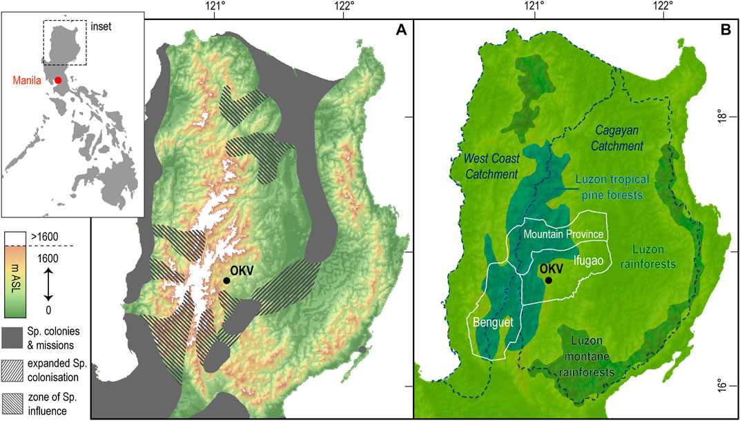
FIGURE 1. Maps of Northern Luzon detailing (A) topography and the extent of Spanish colonization circa 1780 CE and (B) the outline of modern Ifugao province, the three ecotypes of Northern Luzon, and water catchments. Old Kiyyangan Village (OKV) is identified in both maps. The extent of Spanish colonization in the 18th century, shown in panel A, is reproduced from Conklin (1980, 98).
These terraced highland landscapes, now recognized as a UNESCO world heritage site (UNESCO, 1995), were initially assumed by scholars to be two-thousand to three-thousand years old (Barton, 1919; Barton, 1922; Beyer, 1955) and to represent a vivid example of the sweeping impact of past intensive agriculture on tropical forest environments, particularly in montane areas. However, post-1950s research in ethnography (Keesing, 1962; Scott, 1966), linguistics (Reid, 1994), oral tradition (Lambrecht, 1967; Conklin, 1980), and archaeology (Maher, 1973; Conklin, 1980; Acabado S. B. 2012; Acabado S. 2012; Acabado, 2017; Acabado, 2018) all suggest the terraces are relatively young (see Supplementary Material). Rather than being millennia old, they were likely constructed between the 16th and 18th centuries after the Spanish first conquered northern Luzon’s lowlands in 1572–74 CE (Blair and Robertson, 1909). Acabado (2017) has argued that the terraces allowed the Ifugao to function as a “pericolonial society,” as a people influenced by Spain’s conquest of the Luzon lowlands who nonetheless maintained their independence, grew in number, and developed more rigid social hierarchies outside of the colonial system. Furthermore, key to this pericolonial society’s growth, ethnographic and palaeoecological research suggests, was a highly integrated agroforestry system that employed carefully managed woodlots (muyong), swidden fields (uma), and wet-field terraces (payo) that enabled long-term, sustainable cultivation of rice, root crops, and usable tree species. Woodlots were fully incorporated into the Ifugao peoples’ agricultural system, guaranteeing forests were preserved or possibly expanded alongside the intensively cultivated rice terraces (Sajor, 1999; Hayama, 2003; Serrano and Cadaweng, 2005).
Modelling Ifugao land use in the Philippines’ pre-colonial and colonial periods is an opportunity to apply multidisciplinary data to visualize how a burgeoning system of rice agriculture, and its associated population growth, affected local forest cover and how Indigenous socio-ecodynamics responded to a neighboring, aggressive colonizer. Scholars’ capacity to quantify the land use and demographic changes that occurred during this period, however, has historically been limited by a lack of written documents describing the region. The first written sources to mention the terraces were composed in the 19th century, and the earliest academic studies on the region transpired in the 20th. Comprehending past land use strategies in Ifugao therefore requires an interdisciplinary approach that draws upon history, ethnography, archaeology, anthropology, linguistics, ecology, and geography (Wilson, 1998; Izdebski et al., 2016; Rick and Sandweiss, 2020). Recently, an interdisciplinary community effort has emerged (Kay and Kaplan, 2015; Morrison et al., 2018; Kay et al., 2019; Morrison et al., 2021) to synthesize and quantify the longstanding interconnectivity of human and climate history first expounded by Ladurie (1971) and Lamb (1997; see also Harrison et al., 2018; Gaillard et al., 2018; Widgren, 2018).
Here, we quantify historic land use change in the Ifugao region using a simple spreadsheet-modeling approach, which we then visualize through “circle diagrams” (described in Kay and Kaplan, 2015; Hughes et al., 2018). To create these models, we calculate the land required for a settlement with a predetermined population (based on the available archaeological and historical data) to subsist for a single year, presuming no atypical disruptions (i.e. severe natural hazards or invasions), and classify different types of land use according to their intensity. We quantify land use for a principal settlement of the Tuwali-Ifugao people, Old Kiyyangan Village (OKV), which was inhabited from 900 CE until the mid-nineteenth century when it was razed by a Spanish military expedition. We design our models according to Acabado’s (2017) pericolonialism hypothesis, which states that lowland migrants avoiding Spanish dominion swelled the Cordillera’s population, leading to the rapid expansion of rice terraces and the adoption of wet-rice as one of Ifugao’s primary starches. This enables us to explore the potential ramifications of rice intensification and demographic growth. We model OKV land use at two timepoints. The first timepoint, 1570 CE, depicts OKV prior to the Spaniards’ subjugation of parts of Luzon’s lowlands. The second timepoint, 1800 CE, describes OKV just before the first Spanish accounts of the village and its terraces (Scott, 1974). We also present models demonstrating the typical land use of Ifugao’s two predominant social tiers: the kadangyan (elite who frequently consumed rice) and the nawotwot (the poor, whose name literally translates to “root eaters”; Acabado, 2017).
Methodology
Models in Ifugao: The History and Socio-Ecology of the Region
The shift from taro (Colocasia esculenta) to rice (Oryza sativa) cultivation and consumption between 1570 CE and 1800 CE was a remarkable transformation in Ifugao’s socio-ecology. To convey the scope of this transformation, this section offers a brief history of Ifugao province and OKV during the Spanish colonial period. It then describes Ifugao society circa 1570 and 1800, focusing on the emergence of Ifugao’s distinctive agroforestry complex, which emerged as a response to both Ifugao’s geography and the Spanish occupation of the surrounding lowlands. We refer to this as the muyong-uma-payo complex (see Table 1).
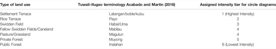
TABLE 1. Ifugao land use terminology as it applies to our land use modelling. The leftmost column names seven types of land use typical to Ifugao. The middle column provides the Tuwali-Ifugao (Kiangan Region) terms for these forms of land use (Acabado and Martin, 2016). The rightmost column assigns each form of land use to an Intensity Tier, reflecting how transformative of the landscape that activity is relative to others. These Intensity Tiers determine where each form of land use is depicted on a circle diagram. This table is inspired by similar tables presented in Conklin’s Ethnographic Atlas of Ifugao (1980) and uses his terms, “Grassland” and “Caneland,” to describe fields overtaken by primary and secondary growth.
Contemporary Ifugao province, which approximates the Ifugao cultural region, is enclosed by the Magat River to its south and the Cordillera Gran’s steepest mountains to its north and west (Wernstedt and Spencer, 1967; Conklin, 1980; see Figure 1). As a result, the province’s topography is defined by deep river valleys where rice cannot grow except in constructed environments like terraces. Terraced rice is able to grow up to 1,600 m above sea level (m ASL), and, not coincidentally, the average elevation of the province’s inhabited regions ranges from 1,000 to 1,500 m ASL (Conklin, 1980). The region above 1500 m ASL comprises broadleaved montane forest interdigitated with Benguet pine- (Pinus kesiya Royle ex Gordon) dominated coniferous forests on steep slopes and ridges as well as in frequently burnt zones (Kowal, 1966; Jain, 1992; Olson et al., 2001; Rabena et al., 2015; Lamoreax, 2021). We refer to this holistically as coniferous montane forest for brevity. Land use in Ifugao settlements—the payo, but also the uma and muyong—take full advantage of this complex geography and the transitional zone (ecotone) from mid-to high-elevation (Figure 2).
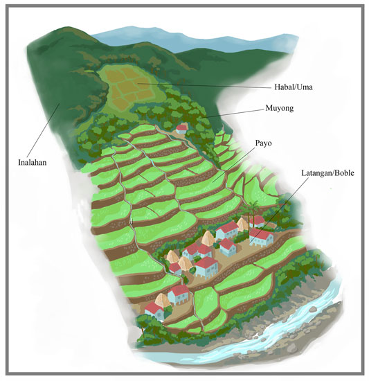
FIGURE 2. A drawing of OKV and its associated land use, with labels. The forms of land use are arranged as they exist in 20th and 21st century Ifugao settlements.
Spanish colonizers became aware of the Ifugao region after establishing control over lowland Luzon in a series of campaigns between 1572 and 1574 CE. Cash-strapped colonial administrators and Spain’s kings were attracted by rumors of gold mines in the western and southern Cordillera, but Ifugao lacked these precious metals (Blair and Robertson, vol. 20, 1909; Morga, 1971; Scott, 1974). As a result, regular contact between the Spanish and Ifugao peoples did not take place until the mid-eighteenth century with the establishment of Ituy and Paniqui provinces (Antolin and Scott, 1970; see Figure 1). Works from that period by friars Antolin in 1789 (see ibid) and Molano in 1801 (cited in Scott, 1974) offer some of the earliest written descriptions of Ifugao. Molano’s account is of special interest since he was the first Westerner to visit OKV, the largest settlement of the Tuwali-Ifugao, and to describe Ifugao’s unique rice terraces (see Figure 2).
Although Molano may not have been aware, OKV held mythic significance to the Tuwali-Ifugao and was an unusually large settlement with fertile land. Oral tradition indicates OKV was the birthplace of rice terrace farming and its associated rituals (Maher, 1984). Writing of the village in the late 20th century, Maher said, “What remains of it can be found there in the Barangay Bullaga surrounded by pond fields on the flood plain of the Ibulao River. The surface is flat, requiring no terracing, and water is abundant and accessible” (p. 119). This corresponds with Antolin’s 1789 descriptions of “Kiangan (Kiyyangan)” and Tuwali-Ifugao lands as fertile compared to other parts of the Cordillera (Antolin and Scott, 1970, 237). However, the village’s size also made it a target. In 1832 CE, a Spanish expedition led by Commander Galvey sacked the village and much of the region. By the 1860s, the village was abandoned (Scott, 1974; Scott, 1982).
OKV’s relative prominence in Spanish documents and its mythological importance to the Ifugao make it an ideal site for land use modelling. Multiple Spanish interactions with the village mean it is relatively well-documented compared to other Ifugao settlements. Furthermore, because of the village’s mythological importance, it has been thoroughly investigated by the Ifugao Archaeological Project (IAP, see1) and is one of the best-researched sites in the province. It therefore is one of the few sites in Ifugao province where historic land use modelling may be attempted, although the village’s exceptional size and fertility mean it is not necessarily a template for the whole province. Nonetheless it is the supposed birthplace of the terrace-based rice cultivation that radically transformed Ifugao between 1570 (pre-Spanish) and 1800 (pre-conquest), and it is therefore an important site for understanding Ifugao agriculture.
Based on Molano’s written accounts (see Scott, 1974), the pre-conquest socio-ecology of OKV was defined by the payo. The payo, though, were only the most visible aspect of a highly integrated agroforestry system, the muyong-uma-payo complex (see Figure 2). The payo were also a basis for social differentiation among the Ifugao (see Table 1). They were constructed in the absence of a central administrative state, but gave rise to a “petty plutocracy” (Scott, 1982, p. 135) where communal labor maintained and expanded terraces owned by the kadangyan, whose regular consumption of difficult-to-grow rice was a primary signifier of their elite status. Complementing the payo were the muyong, carefully managed woodlots that contained as many as 200 plant species that were used for food, construction, fuel, and medicine (Sajor, 1999). Located uphill of terraces, muyong supported rice cultivation by hindering runoff and erosion, simultaneously protecting the terraces and ensuring regular access to water. Finally, kadangyan who did not own many terraces as well as Ifugao who did not own terraces, the nawotwot, consumed root crops such as iuktu (ubi, purple yams, Dioscorea alata) or, more recently, gattuk (camote, sweet potatoes, Ipomoea batatas) grown in uma (swidden fields). Uma were typically located near muyong uphill of payo on arable land unsuitable for rice cultivation (Conklin, 1980; Sajor, 1999).
Less is known about the pre-Spanish socio-ecology of Ifugao. Palaeobotanical evidence suggests rice was entirely absent, that taro and root crops were OKV’s primary starches before 1570, and that these crops were grown in less-extensive terraces and swidden fields (Acabado S. B. 2012; Acabado S. 2012; Horrocks et al., 2018). Studies employing radiocarbon dating indicate terracing substantially increased in the 17th and early 18th centuries, after the Spanish arrived in the Philippines (Maher, 1973; Conklin, 1980; Acabado et al., 2019). Based on research performed by the IAP in OKV, Acabado theorizes that increased terracing was attributable to population growth partially caused by an influx of migrants from the lowlands where rice cultivation was practiced. This population increase catalyzed both the rapid expansion of pre-existing terraces and the adoption of rice, a more productive staple, amongst social elites (Bray, 1994; Acabado S. B. 2012; Acabado S. 2012; Eusebio et al., 2015; Acabado, 2017). The shift to wet rice cultivation, Acabado asserts, provided the basis for pronounced social differentiation amongst the Ifugao, helped them resist multiple Spanish incursions and ultimately helped create a pericolonial society (Acabado, 2017; Acabado, 2018).
The Historical Land Use Model
We use a historical land use model to quantify the amount and type of land used by the residents of OKV. The model, first conceptualized by Gregg (1988) and elaborated in subsequent studies (Kay and Kaplan, 2015; Weiberg et al., 2019), posits that land use is a function of the properties of the physical environment and the socio-cultural characteristics of the people who use the land. The former includes topography, climate, soils, and vegetation and can be reconstructed for the past based on modern survey and paleoenvironmental proxies. The latter consists of the most significant components of a population’s diet and their methods of agriculture, agroforestry, animal husbandry, hunting and gathering, pottery production, and metallurgy. Reconstructing the socio-cultural characteristics of past societies draws upon published archaeological, ethnographic, and anthropological research.
Hughes et al. (2018) describe the past land use modeling process in detail, and term the socio-cultural characteristics “livelihoods”. These livelihoods describe the human inputs to food production that, along with the properties of the physical environment, are used to determine the yield of the principle food crops and animal products. With an initial estimate of the size of the human population, the land use model is used to approximate the amount of land required for a settlement to subsist for a single year.
Here, our model quantifies land use for an imagined year where no significant demographic change, famine, or abnormal disruptions transpire. Since natural hazards are frequent in the Philippines, our model assumes moderate damage from typhoons and earthquakes, and therefore expanded land use associated with repairs, was part of a typical year (Bankoff, 2009). However, since statistics on all but the most exceptional historic typhoons and earthquakes are rare, particularly in the Cordillera region, we are forced to make generalized assumptions about the damage they caused every year (see Bankoff, 2003). It is also essential to note that our model attempts to quantify land use at specific points in time, but does not make any assumption on how or when change transpired. As a result, our models of OKV at two timepoints only identify changes that happened in intervening years, not their cause or tempo.
Following Kay and Kaplan (2015), we recognize that different forms of land use lead to different transformations of the physical environment. For example, a village or garden would represent an obvious anthropogenic modification of the natural landscape, while a forest in which hunting and gathering takes place might only be appreciated by someone intimately familiar with the local environment. Thus, land use leads to a hierarchy of impacts on the landscape. For Ifugao, we pre-define the types of land use calculated by the model and their relative intensities (Table 1).
The land use model is coded in an Excel spreadsheet and contains user-definable parameters describing both livelihood and properties of the physical environment that can be adjusted based on uncertainties in diet, inputs, climate, population size, etc. The model output consists of a table of the area in hectares required for each type of land use.
In order to aid in the rapid interpretation of the model results and facilitate comparison between outputs using varying underlying assumptions or for different periods, we use the circle diagram (Kay and Kaplan, 2015; Hughes et al., 2018). A circle diagram presents the land use model output as a series of colored concentric rings, where each ring represents a specific land use at a certain hierarchical level (Table 1). Where two or more land uses have the same relative intensity, both are shown as distinct sectors in the ring at that level. The integrated area of each ring/sector represents the area required for that particular land use. We use a custom script for the Generic Mapping Tools software (Wessel et al., 2019) to take the tabular output from the land use model and plot the circle diagrams. The full plotting code and model output used in this paper are published on Zenodo (Kaplan, 2022).
Model Calculations for OKV
Our models for OKV in 1800 rely on 20th century ethnographic research supplemented by palaeoecological and archaeological research in Ifugao, especially the on-site investigations at the OKV by the IAP. We assume 20th century ethnographic research is useable for the 1800 timepoint based on archaeological evidence and Ifugao oral tradition, which indicate the terraces and their associated social institutions are at least ten generations old (Lambrecht, 1967; Maher, 1973; Conklin, 1980; Acabado, 2017). We acknowledge that relying on ethnographic evidence assembled in the previous century is potentially problematic as Ifugao society was and is dynamic. However, the lack of regular historic documentation of Ifugao forces us to make these assumptions. For the 1570 timepoint, for which no written historical documents exist, we rely exclusively on archaeological and palaeoecological evidence and assert that OKV in 1570 CE grew taro as its primary subsistence crop to support a smaller population. As a result, both our pre-Spanish and pre-conquest models are built upon several informed assumptions, which are a source of uncertainty in our models. To explore how these uncertainties can produce significant variations in our model results, we also run a series of simulations (or “sensitivity tests”) covering a range of input values.
The remainder of this Methodology section is dedicated to describing the information we use to assemble our model calculations with a focus on our template or initial models. These models represent what we believe to be the probable land use of OKV at our two timepoints. This section is organized according to the three broad categories of data used in land use modelling: population, “livelihood,” and yields and nutrition. Throughout, we summarize the data we gathered and the assumptions we made. When necessary, more detailed descriptions of our data are included in the Supplementary Material. We also allude to points of uncertainty in our templates and how we test the potential error introduced by these uncertainties. These are discussed in detail in the Supplementary Material, where we demonstrate they do not alter our primary conclusion: that intensification, particularly expanded terracing, and the initiation of widespread rice cultivation allowed OKV to have lower per capita land use in 1800 than in 1570, even though the village’s population in 1800 was double what it was in 1570.
Population and Boble (Settled Area) at OKV
There is no census or comparable document describing OKV in 1800 CE or 1570 CE, nor are there any surviving, precise descriptions of OKV’s size at either of these times. Further, because the Ifugao peoples’ settlement patterns are intricately linked to their payo, one cannot determine per capita land use and from that extrapolate the settlement’s size based on empirically observed relationships between population and settlement size (see Ortman et al., 2014). As a result of these complicating factors, how we determine the settlement’s size is inextricably connected to what we expect OKV’s population was. A full explanation of how we derived the estimates for population and settlement size that we provide below can be found in our Supplementary Material.
For the 1800 timepoint, we estimated the population and size of the settled area using a combination of Molano’s 1801 account of OKV (Scott, 1974), Maher’s (1973) observations on how payo can be repurposed as “settlement terraces,” Conklin’s (1980) observations on the Ifugao hamlet of Buble, and Acabado (2017) and the IAP’s research fieldwork at OKV. We presume OKV contained 284 houses (Scott, 1974), with the majority occupying a 3.39 ha nucleated settlement and the others dispersed throughout the payo (see section 3.3.2). Assuming that bale (houses) held on average 3–4 individuals, we expect OKV’s population in 1800 was at minimum 852 and at maximum 1,136. We use the maximum expected population in our templates. Given population densities reported by Conklin (1980) that were also supported by Barton (1922), and using Molano’s description of OKV’s satellite villages as a guide (Scott, 1974), we calculate that OKV in 1800 would have required ∼5.55 ha of “settled area” for 1,136 people.
For the 1570 timepoint, there are no contemporaneous written accounts that indicate the full extent or population of OKV. However, as per the pericolonialism theory and research led by the IAP and Acabado, it is known that the nucleated settlement was 1.70 ha, half the size it would be in 1800 (Acabado, 2017). It is also known that taro, a less productive crop than rice or sweet potatoes, was the primary staple that was grown in both swidden field and terraces (Acabado S. B. 2012; Acabado S. 2012). So, because we expect Ifugao settlements were dispersed in 1570 as well, we conclude that OKV’s settled area in 1570 was half of its size in 1800: ∼2.78 ha. Since we lack any information on OKV’s population in 1570, we assume OKV’s population was also half its future maximum size and contained 568 people. Again, because we assume OKV’s settled area included various dispersed hamlets, we do not use Ortman et al.’s (2014) observed relationship between nucleated settlement size and population. However, we must emphasize that this estimate for total population is a rough estimate and cannot be proven or disproven based on existing evidence from the OKV site.
Payo (Terraces)
Despite the labor expended on rice cultivation and its cultural significance, rice only met approximately 25–33% of OKV’s carbohydrate requirements circa 1800 CE (Barton, 1922; Acabado et al., 2018). Because rice and a small quantity of taro were grown in payo, we determine the area terraced for rice cultivation by calculating how much rice the village’s population would have required to produce a surplus, to be used either in trade or as a precaution against hazards. We then add on the amount of land required to grow the small amount of taro consumed annually.
For the 1570 CE timepoint, since terrace agriculture was less extensive than in 1800 and was primarily used for taro cultivation, which can occur in either wet or dry fields, we presume a much smaller amount of land was terraced. Given the labor requirements of payo, the size of OKV in 1570, and the premises of the pericolonialism hypothesis, we expect ∼13.4 ha of land were terraced for growing taro in OKV in 1570 (see Supplementary Material section 3.3.1).
Before continuing, we should note that terraces were routinely damaged and repaired. However, these repairs do not contribute to land use in our model for three reasons. First, a high proportion of terrace walls in the Tuwali-Ifugao are built of earth, not stone. Second, the sandstone used in stone walls was often gathered from cleared uma, muyong, or other sites uphill of the terraces, which permitted villagers to move these heavy materials downhill with water. If no stones were available uphill, the villagers of OKV would have used stones and boulders from the nearby Ibulao River instead. Third, Ifugao quarrying, when it did transpire, was not especially transformative of the landscape; boulders were not dug up, but instead were gathered, broken apart using other rocks, and then hauled to the terraces. For these reasons, we do not measure quarrying in our models and presume terrace repair had a negligible effect on land use (Conklin, 1980).
Uma (Swidden Fields)
In contemporary Ifugao, swidden fields are positioned on fertile land unsuitable for terracing, are often close to muyong, and are relatively distant from villages and hamlets. Today, swidden farming is used to primarily grow sweet potatoes, though taro can also be grown in wetter years. Swidden fields are prepared during the dry season by first cutting cane or woodland and enacting a controlled burn; wood or cane that does not burn fully can be saved for fuel (Conklin, 1980). A swidden plot is cultivated for 2–3 years, with each year experiencing successively smaller yields. It is then left to lie fallow for 5–6 years, at which point primary growth is cleared again or the field is cultivated as a woodlot. In years when rice harvests are expected to be poor, swidden agriculture can be rapidly expanded into unclaimed forests or fields (Conklin, 1980).
Ethnohistorical accounts by Antolin indicate gattuk (sweet potato), aba (taro), and iuktu (purple yams) were grown in swidden fields circa 1800 CE (Antolin and Scott, 1970), and Barton indicates that, by the 20th century, sweet potato had entirely replaced yams in Ifugao diets. Given this information, we assume gattuk and iuktu were grown simultaneously in uma circa 1800, with a small amount of aba also being grown. In our template diagram, we presume iuktu and gattuk were equal components of OKV’s diet.
For 1570 CE, swidden crops, particularly aba and iuktu, are presumed to have been OKV’s primary source of energy based on archaeobotanical and archaeological evidence (Acabado S. B. 2012; Moran, 2015). For both timepoints, we expect vegetables such as squash, were also grown in swidden fields or along the bunding atop terrace walls (Antolin and Scott, 1970; Conklin, 1980; Amano et al., 2020). In 1800, we assume the most common squash was kalabasa (Cucurbita maxima). However, since kalabasa was first introduced to the Philippines from the Americas during the Spanish period, it would not have been present in OKV in 1570. Instead, similar vegetables such as squashes indigenous to East and Southeast Asia would have been grown. Our models assume these vegetables had similar productivity to kalabasa.
Muyong (Private Forests)
Historically, edible plants grown in muyong included mangoes and bananas, with the latter being the most prevalent (Antolin and Scott, 1970). It is also possible, though not confirmed, that breadfruit was cultivated in woodlots (Acabado et al., 2018). Tobacco, a plant originally imported from the Americas, may also have been cultivated in personal gardens, muyong, or uma in 1800 CE, though we do not discuss its cultivation in our models.
In 1800, kadangyan and nawotwot alike obtained their fuel and resources from kadangyans’ muyong. Typically, nawotwot were permitted to gather dead branches and even chop down dead trees in exchange for laboring to maintain kadangyans’ muyong (Conklin, 1980; Hayama, 2003; Serrano and Cadaweng, 2005). These muyong would have contained hardwoods for bale (house) construction (Scott, 1966), which we find did not significantly contribute to land use (see Supplementary Material).
We have little information on forestry practices in 1570, prior to increased terrace building. As terraces were still present, we assume managed forests were also maintained uphill of those terraces and their size was primarily determined by the village’s food and fuel requirements (see Kay and Kaplan, 2015).
Domesticated Animals
In contemporary Ifugao, domesticated animals including carabao (water-buffalo, Bubalus bubalis), pigs, and chickens are sacrificed at various stages of rice cultivation. Notably, only domesticated animals are considered suitable for sacrifice (Lapeña and Acabado, 2017). Chickens are most frequently sacrificed, followed by pigs, and then carabao, which are only sacrificed during the harvest period (Conklin, 1980; Conklin, 2002). Among these animals, pigs and especially carabao are prestige animals. They are owned by kadangyan, and they are sacrificed and distributed during communal feasts (Conklin, 1980; Brosius, 1988; Lapeña and Acabado, 2017). However, carabao are only shared among other kadangyan, while pig parts are more widely distributed with various parts considered more prestigious gifts than others. By contrast, chickens and their eggs are an easily accessible source of protein and are commonly raised throughout settlements (Conklin, 2002). When chickens are ritualistically sacrificed, they are consumed by the ritual leader (mumbaki), but the meat is not distributed (Barretto-Tesoro, 2007).
For 1800 CE, zooarchaeological evidence from OKV indicates four domesticated animals were common: dogs (Canis familiaris), chickens (Gallus gallus), pigs (Sus scofra), and water buffalo or carabao (Ledesma et al., 2015). Although no remains were found, it is also possible goats were present in OKV, presumably in small numbers (Amano et al., 2020). While our template diagram does not account for goats, we do discuss what effects they might have had in our Supplementary Material.
Of the animals confirmed to be present in 1800 CE, carabao—these are large grazing animals averaging over 400 kg in size—would have had the most significant effect per animal on land use. It is unclear, though, whether very small carabao herds were kept or if these animals were purchased from the lowlands (Ledesma et al., 2015). For our template models, we assume a small herd of ∼22 animals was kept at OKV, and we detail other possible herd sizes in our Supplementary Material.
Domestic pigs were the most common large animal, though ethnographic evidence indicates they had a very small effect on land use in OKV. This is because pigs, like chickens, were raised within settlement terraces near homes. Further, pigs’ caloric needs could have been met with plant and animal waste generated from farming and hunting as well as from human waste (Conklin, 1980; Gregg, 1988; Conklin, 2002; Huynh et al., 2007). Nevertheless, for nutritional reasons, we assume 10% of pigs’ caloric needs were met by browsing in forests. Browsing occurred in muyong or public forests between the rice harvest and the reseeding of the terraces (Conklin, 1980).
The same suite of domestic animals was present in 1570 CE, except possibly carabao (Acabado, 2017). Based on existing zooarchaeological evidence we expect that fewer domestic pigs and no carabao were present (Ledesma et al., 2015; Acabado, 2017). Therefore, we calculate animal-associated land use in 1570 was significantly less than it was in 1800.
Hunting, Foraging, and Fishing
Zooarchaeological evidence indicates that, in both 1570 and 1800 CE, a substantial portion of OKV’s dietary needs were met through hunting and gathering. According to Antolin, Ifugao and other highland peoples hunted in the foothills of the Cordillera, particularly in wooded regions where larger mammals proliferated (Antolin and Scott, 1970). Zooarchaeological reconstructions of faunal assemblages (Number of Identified Specimens-NISP, Minimum Number of Individuals-MNI) undertaken by Ledesma et al. (2015) indicate wild deer (Rusa marianna) were the most consumed animal in Ifugao, followed by wild pigs (Sus philippensis). Various bones attributed to different small game were also preserved at OKV. Lastly, a small percentage of bones at OKV were attributed to mudfish (Channa striata), a freshwater fish common in the Ibulao River (Ledesma et al., 2015). In modern times, this fish and various shellfish from the river are often introduced and maintained in terraces, where they promote soil fertility and are an easily obtained source of protein (Conklin, 1980).
Given the known biases of NISP and MNI counts against small animal bones and fish bones as well as the relative dearth of studies undertaken at OKV, we suspect small game and mudfish and other freshwater life comprised a larger fraction of historic diets than suggested by Ledesma et al. (2015; see also Barton, 1922; Conklin, 1980). Additionally, for both 1800 and 1570 CE, we assume residents of OKV consumed wild game more frequently than domesticated animals, and large animals like wild deer and pigs were shared among families and villages once slaughtered.
Fuel and Resource Extraction
Ethnographic evidence suggests the primary fuel source for the Cordillera and parts of Ifugao was Benguet Pine, which could be gathered in muyong or while clearing swidden fields (Antolin and Scott, 1970; Scott, 1975; Conklin, 1980; Manuta, 1993; Jang and Salcedo, 2013). However, Benguet Pines grow best at elevations between 1,000 and 2,500 m ASL and likely would have been interspersed with tropical montane oaks and other broadleaved trees in OKV’s muyong (Dinerstein et al., 2017; Lamoreax, 2021). Since most societies do not limit themselves to one type of tree, but instead gather wood from various species as long as they lack religious or cultural significance, we assume Ifugao peoples in both 1570 and 1800 CE relied on several tree species for fuel (Picornell-Gelabert, 2020). The species they selected would likely have included Benguet Pines, molave oaks, and species that released as little smoke as possible. Given these criteria and the species available near OKV, our model postulates that local fuel-woods had an average energy content of approximately 20 MJ/kg (Bhatt and Tomar, 2002; Kay and Kaplan, 2015).
For both 1570 and 1800 CE, we calculate that OKV’s annual fuel consumption was approximately 476 kg per capita (Donovan, 1981; de S. Wijesinghe, 1984; Kay and Kaplan, 2015). Because individuals who did not own a muyong were often permitted to gather fallen trees for firewood by kadangyan in exchange for their labor (Manuta, 1993; Hayama, 2003), we expect kadangyan and nawotwot alike gathered fuel exclusively from muyong in 1800. In 1570, we likewise presume firewood was gathered from managed woodlots.
Pottery and metallurgy can significantly increase the demand for fuel and other resources. Pottery production in Ifugao, according to Acabado et al. (2018), did not experience substantial change and remained decentralized (occurring in each household as per a family’s need) between 1570 and 1800. We therefore assume pottery requirements for each person in 1570 were near identical to those in 1800 (Lauer and Acabado, 2015). Critically, Ifugao traditional pottery is fired by filling the earthenware pot with twigs and grasses that are then combusted with the container doubling as a heat trap (Maher, 1984). Therefore, we conclude neither the gathering of clays nor fuel for firing had a significant effect on land use.
Ifugao, unlike all other regions of the southern Cordillera, did not practice extensive mining in 1570 or in 1800. However, Antolin noted that the Ifugao frequently purchased iron waste from lowlanders, which they would then melt to create new tools and weapons (Antolin and Scott, 1970). As a result, we conclude gathering ore in Ifugao required no significant land use. Friar Antolin also observed highlanders from neighboring regions (Benguet) using hollowed tree stumps as furnaces to melt and reshape the metal, suggesting fuel-use for these furnaces would have been significant (Antolin and Scott, 1970). To calculate annual fuel-use associated with iron for both timepoints, we employ the procedure designed by Kay and Kaplan (2015): we assume each individual person, regardless of age, required 1.5 kg of iron per year on average, which necessitated 492 kg of fuel per year per capita.
Commerce
Antolin reported that the Ifugao would primarily trade rice with lowlanders in exchange for worked iron pieces and various animals, including domesticated pigs and carabao (Antolin and Scott, 1970). Furthermore, recent research undertaken by the IAP indicates prestige goods, such as Chinese ceramics, were desired by kadangyan (Yakal, 2017). Since we do not know the extent of this commerce, we cannot precisely calculate its effect on land use. However, we presume commerce was primarily undertaken by (or for the sake of) kadangyan and that a surplus of rice was produced most years—set to 30% in our models, an amount that would permit poorer harvests to not affect kadangyan diets—of which a portion was used for trade. The land dedicated to surplus rice production would therefore also be the most significant form of land use associated with commerce.
It must be noted that our model does not describe tobacco production in OKV. The Galvey expedition of 1832 CE was, in part, triggered by the sale of Ifugao tobacco in the lowland Philippines (Scott, 1974). At the time, the Spanish were attempting to enforce a tobacco monopoly, established in the late-eighteenth century, to increase the Philippine colony’s profitability (de Jesus, 1998) and begrudged the Ifugao for undermining that monopoly. Unfortunately, estimating the amount of tobacco grown in OKV and sold in the lowlands as contraband circa 1800 CE is exceedingly difficult. Based on anecdotal evidence and the severity of the colonial administration’s 19th century expeditions to Ifugao, we can assume the amount of tobacco grown was not insubstantial (Scott, 1974). However, we lack sufficient data to make an informed estimate at this time.
Agricultural Productivity and Nutritional Value
Extensive records of historic crop productivity do not exist for Ifugao prior to the 20th century, so we instead rely on agricultural research performed in the province and the Philippines in the past 6 decades, which often discusses traditional yields in comparison to high productivity crops (see Tulin, 2014). Using such material, we assemble a range of viable historic yields for each crop, and then employ the average yield in our models. If a reliable historic range cannot be established for a specific crop, we instead establish a range of modern yields for that crop and assume the minimum corresponds to the historic average production (see Supplementary Material). Furthermore, we assume yields for all crops did not change between 1570 and 1800 CE. In this way, we establish probable historic productivities based on the limited evidence available, and we utilize these productivities in our template models. We discuss yield as a source of uncertainty in our Supplementary Material.
Similar to historic yields, there is no accurate account of foods’ historic nutritional value in Ifugao. We instead rely on analysis performed by the CINE group at McGill University (Centre for Indigenous People’s Nutrition and Environment) on the diets of the Aetas of Morong, Bataan in Luzon (Santos-Acuin et al., 1997; Kuhnlein et al., 2006), supplemented by publicly available nutritional values published by the United States Department of Agriculture (USDA). Unlike productivity, it can be safely assumed that the caloric content of species found in Bataan and Ifugao do not significantly differ. We expect no significant change in foods’ nutritional and caloric content between 1570 and 1800.
Dietary Proportions
Our model does not currently explicitly enforce a balanced diet, only a minimum total caloric intake. Therefore, to ensure realistic dietary proportions, we assume Ifugao peoples in both 1570 and 1800 CE consumed starches, proteins, and vitamins in similar ratios to those observed by Barton (1922) and Conklin (1980). Of the two, we prioritize Barton, whose quantitative descriptions of Kiangan, Ifugao diets are among the earliest available. However, there is no guarantee diets did not change between 1800 and the 20th century, and the peri-colonialism hypothesis asserts diets changed profoundly between 1570 and 1800 (Moran, 2015). Therefore, the dietary proportions we use in our template models are informed estimates, reflecting what we believe is a probable scenario for past diets (the inherent uncertainty of this approach is discussed in the Supplementary Material).
In our template models for both timepoints, we suggest starches constituted approximately 76% of annual diets with all other foods comprising the remaining 24%. This remaining percentage, we posit, was primarily comprised of vegetables and fruits, fish, and hunted game (especially small game). We expect domesticated animals did not account for more than 4% of annual diets. Variations in the consumption of various plants and animals between 1570 and 1800 transpire within these constraints, which reflect Conklin and Barton’s observations.
Results
Our results are presented in three sections. The first presents our template diagram for 1800 CE. This diagram presents what we maintain is a probable pattern of land use, given existing evidence. The second section offers a similar template diagram for 1570 CE. The final section presents the imagined land use of a hypothetical kadangyan family that only consumed rice as a starch and a hypothetical nawotwot family that only consumed tubers as starches. In all three sections, we present our results using circle diagrams, a series of concentric circles representing different types of land use differentiated by intensity. The settlement is plotted as the centermost circle. Surrounding the settlement are five rings. They contain, in order of descending intensity: terraces; active swidden fields; fallow swidden fields and pastureland; agroforestry and woodlots; forested land for pigs to browse and hunting space.
1800
Our template diagram for OKV in 1800 CE is presented in Figure 3. We assume the village contained 284 houses and 1,136 individuals, the maximum population we allowed for in Population and Boble (Settled Area) at OKV. As per our Methodology (Section 3.3), we expect that iuktu (purple yam) and gattuk (sweet potato) comprised equal portions of diets at OKV; that a small herd of carabao (∼22 animals) were present in the village; and that goats were absent from the village. Lastly, for the sake of clarity, all land use numbers presented here, excepting the Settlement, are approximations. For more precise numbers, see the datasheets included in the Supplementary Material.
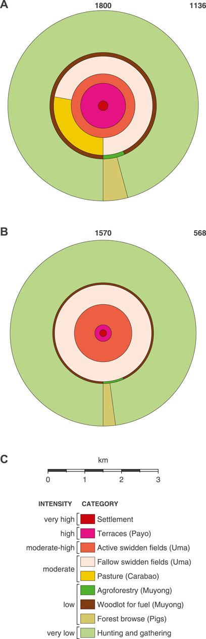
FIGURE 3. Template circle diagrams for OKV in 1800 (Panel A) and in 1570 (Panel B). The figure also includes a legend (Panel C) with a scale. The legend lists all types of land use and their intensity relative to one another. In each panel, the number in the upper right corner represents the population whose land use is being modelled.
We calculate that a village of this size, operating within the constraints listed above, would require ∼2,113 ha of land to subsist for a single year, with the majority of this land being hunting land. Hunting would require 1,390 ha, while all other forms of land use would require ∼723 ha of land. Assuming that the historic yield of rice was 1650 kg ha−1; that historic taro’s yield was 2000 kg ha−1; and that the village produced 30% more rice than required for subsistence, the village would have required ∼112 ha for payo (terraces). Of this terraced land, ∼15 ha would have been required to grow taro, despite it only comprising 2.2% of annual diets in our template model (compared to rice, which represented 32% of annual diets).
Furthermore, we expect houses and hamlets were scattered among these terraces (see section 3.3.1), so the 5.55 ha of land comprising the settlement circle was not consolidated around a single nucleus. This lowered population density and maximized individual access to the terrace paths and bunding, so the whole village’s kalabasa (squash) and other garden vegetables could have been grown in personal gardens or along terrace bunding and pathways (Conklin, 1980). In this way, kalabasa or garden vegetables were fully integrated into other forms of land use.
In addition to the payo, our model asserts that OKV required ∼120 ha of active uma (swidden fields) to grow iuktu and gattuk each year, as well as ∼240 ha of fallow land. Additionally, as discussed in section 3.1, supporting the payo and uma were the muyong, the indispensable managed forests. We calculate that OKV would have required ∼6 ha of muyong for fruits and another ∼85 ha for fuel and other essential resources. Therefore, the village as a whole would have required ∼91 ha of muyong in total to support 1,136 individuals circa 1800.
Based on the community of 1,136 individuals’ caloric needs as well as the physical requirements and breeding habits of pigs and carabao, we expect OKV would have contained ∼391 pigs and ∼22 carabao. The carabao, as grazing animals, would have required ∼93 ha of pastureland (Conklin, 1980). We expect pigs, as foraging omnivores, were primarily fed agricultural waste—failed tubers and the green material from various crops—and human waste products (Gregg, 1988; Conklin, 2002). The 10% of their diet derived from forest browse would have required ∼61 ha annually. Conklin’s (1980) research on ritual sacrifice suggests these herds would have been too small to meet OKV’s ceremonial obligations, and therefore commerce with the lowlands to obtain additional pigs and carabao was essential, which agrees with all ethnohistorical evidence (Scott, 1966; Scott, 1974; Scott, 1982).
1570
By using Acabado’s pericolonialism theory to argue that wide-spread terracing transpired only after the Spanish arrived in Luzon, we can create a feasible model for OKV in 1570 CE. This model describes a configuration of pre-Spanish land use in Ifugao that can be tested in future research. Our template diagram for OKV in 1570 is presented in Figure 3. This diagram assumes the population was 568, and the settlement circle was ∼2.7 ha, half the size of the settlement in 1800, and no rice was grown in the village as per the pericolonialism hypothesis (see also Horrocks et al., 2018). Instead, terraces were used to grow a portion of OKV’s taro. We assume taro constituted 32% of annual diets, while yams comprised 44.3% of annual diets (sweet potatoes not having been introduced yet constituted 0% of diets). We expect 12% of taro was grown in terraces while the remaining taro and all yams were grown in swidden fields. This would require ∼177 ha of active fields, ∼354 ha of fallow fields, and ∼13.3 ha of terraces (meaning the agricultural and residential terraces together amounted to ∼16 ha of land). Additionally, our model calculations predict half as much highly managed forest would have been needed for a population of 568, so OKV in 1570 would have required ∼46 ha of muyong (3.02 ha for fruits, 42.60 ha for fuel). And lastly, our model expects ∼30 ha of unmanaged forests were used for pigs to browse.
Zooarchaeological evidence is inconclusive on whether OKV in 1570 possessed or consumed carabao. For this model, as per Acabado’s hypothesis (2017), we assume carabao were not consumed or raised in OKV in 1570. We do expect OKV raised and consumed domesticated chickens and pigs as well as hunted game in similar proportions to OKV in 1800. However, because the Ifugao region’s population density would have been lower (half what it was in 1800, based on our models’ existing assumptions), the amount of land available for hunting would have been greater in 1570 than in 1800.
In total, our model concludes OKV circa 1570 would have required ∼2,013 ha of land. Of this land, 623 ha of land would have been dedicated to all activities except hunting. This is in contrast to OKV in 1800, which required ∼2,113 ha of land, of which only ∼723 ha were dedicated to all activities aside from hunting. Therefore, our models suggest increased terracing and the switch from taro to rice, as well as the introduction of sweet potato, permitted OKV’s population to double without greatly increasing the amount of land devoted to starch production. Further, even the addition of grazing animals like carabao by 1800 does not change or challenge this conclusion. This minimization of high intensity agricultural activity undoubtedly helped OKV preserve wild deer and pigs’ habitats and therefore continue to practice widespread hunting. This, and the highly sustainable muyong-uma-payo system of integrated agriculture all indicate historic Ifugao society was premised on a stable pattern of land use that, when bolstered by commerce with the lowlands, permitted large populations to survive and maintain independence in the Cordillera.
The points of uncertainty in our model, discussed in the methodology, do not challenge this conclusion. In the Supplementary Material, we model scenarios for the 1800 CE timepoint with the potential to change our conclusion. We do not model for 1570 because less palaeoecological data is available for this timepoint, and our model for it is primarily based upon the pericolonialism hypothesis. Our scenarios for the 1800 timepoint include: varying the population of OKV; varying the daily caloric intake of individuals at OKV; varying the amount of gattuk and iuktu grown at OKV; removing the carabao herd at OKV; adding a goat herd to OKV; modelling a failed rice harvest at OKV caused by a strong typhoon or similar natural hazard; and modelling how hunting ranges could be affected by Ifugao’s historic population density. These scenarios confirm the amount of land used for all activities except hunting varied from 543 ha at minimum to ∼998 ha at maximum. All confirm intensive land use would not have increased proportionally with population, suggesting Ifugao land use in 1800 was markedly more consolidated than in 1570; was remarkably efficient; and did not rely on extensive deforestation but instead maintained muyong as well as public forests and hunting grounds.
Exploring Social Difference: Kadangyan and Nawotwot Land Use in 1800
The land used to feed a family of kadangyan was distinct from the land used to feed a family of nawotwot, and the land use model calculations can reflect this (Hughes et al., 2018). In Figure 4, we present two circle diagrams depicting the land use associated with two families of four individuals. Panel A depicts kadangyan land use and panel B depicts nawotwot land use. For this diagram, we gave each family an idealized diet, representing the wealthiest kadangyan family possible and the poorest nawotwot family possible. The kadangyan in this diagram are imagined to have consumed only rice and taro as starches, while the nawotwot consumed only yams and sweet potatoes as starches. Both imagined families, however, are presumed to consume the same proportion of starches annually (∼76.2% of their total diet). Additionally, the kadangyan in our scenario consumed carabao and a larger proportion of domesticated pigs than the nawotwot, who would have owned and sacrificed fewer pigs and no carabao (see section 3.3.5).
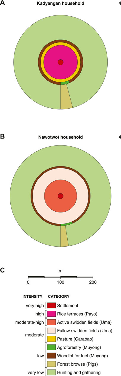
FIGURE 4. Circle diagrams describing the hypothetical land use of a kadangyan family of 4 (Panel A) and a nawotwot family of 4 (Panel B). As with Figure 3, a legend with a scale is also included (Panel C). In each panel, the number in the upper right corner represents the population whose land use is being modelled.
Our models indicate that a kadangyan family of four, given these parameters, would require 6.62 ha of land to subsist for a year. That land would be divided as follows: 0.02 ha for living space, 0.84 ha for terraces, 0.33 ha for pastureland, 0.32 ha for muyong, 0.21 ha of forest for pigs to browse, and 4.89 ha for hunting. By contrast, the nawotwot family would require the same amount of land for hunting, muyong, and living space, but no land for terraces or pasture for carabao. Instead, they would require 0.77 ha of active uma, 1.55 ha of fallow uma, and 0.13 ha forest for pigs to browse. Altogether then, the nawotwot family would need 2.79 ha of actively modified land per year to subsist, while the kadangyan family of the same size would require 1.73 ha of land.
The diagrams presented in Figure 4 help explain how land use in the 1800 timepoint did not double from 1570, despite the population doubling. Payo, a hallmark of the kadangyan class, use less land than uma. In a village like OKV, which evidence suggests was more suitable to rice agriculture than most of Ifugao (Barton, 1922), this means a high proportion of the population could have utilized payo, and their consumption of rice would have helped decrease land use even as the population grew. Nonetheless, it should be noted that a kadangyan family of four could not exist in a vacuum. While terrace construction does not require generations of laborers as once supposed (Acabado et al., 2019), building and maintaining them does take a village. As Conklin (1980) observed, a hectare of highland terrace requires 630 human days of labor per year to maintain, while a swidden field of the same size only requires 250 days. Therefore, without a large population, the Ifugao terraces would not be viable. The same principal applies to hunting for both kadangyan and nawotwot. Hunting was not undertaken by family units but instead was a community endeavor. Again, the hypothetical families we model here did not exist in a vacuum, but were instead part of a community that enabled them to enact this specific land use pattern.
Discussion
In this study, we modelled land use in OKV in 1570 and 1800 CE. Using data gathered from ethnography, anthropology, archaeology, and history, our model calculations quantify how population growth and social differentiation affected land use in OKV circa 1800 CE, reaffirming that land use modelling can be used successfully to quantify how social status affects a society’s ecological impact (Hughes et al., 2018). Furthermore, by applying the pericolonialism hypothesis advanced by Acabado (2017), we were able to estimate land use in OKV circa 1570 CE. Our calculations show that the adoption of intensive rice agriculture and widespread terracing, as well as the adoption of sweet potato, could have permitted OKV’s population in 1800 to be double what it was in 1570 without experiencing a proportional increase in intensive land use and deforestation.
Our models confirm, as several earlier studies suggested, that the muyong-uma-payo complex was a highly efficient and sustainable land use system. It is often assumed that societies will abandon extensive agriculture (i.e., swidden techniques) for intensive agriculture (i.e., terracing) as their populations increase (for examples, see Geertz, 1963; Boserup, 1965; Chrisholm, 2007) and that this in turn, will have deleterious impacts on the landscape in the form of forest clearance, biodiversity declines, and soil nutrient losses. Historic Ifugao’s tandem agriculture not only contradicts this theory but also developed in a non-state society where status was derived from prestige crops and feasting. Our model calculations instead confirm the value of an agricultural system reliant on both terracing and swidden techniques. Ifugao’s distinctive agroforestry system also sustained OKV and the Tuwali-Ifugao during their prolonged resistance to imperial subjugation by maintaining widespread forests that provided essential resources and a habitat for wild game. The necessity of extensive muyong and public forests suggests population increase would not have led inexorably to deforestation or the denuding of mountain sides. Further, unlike lowland paddy fields, rice terraces would not have contributed to soil degradation due to a combination of traditional “green fertilizer” (mulch) and the rigorously maintained irrigation system used to replenish the ponds’ water and soil (Sione et al., 2017). Instead, the effects of increased population were likely more subtle and could have included the deliberate or unintended favoring of trees that grew faster at higher elevations (e.g., pioneer forest taxa) or the increased growth of usable tree species. Alternatively, certain utilizable species might have been depleted faster, causing them to become rarer in the Ifugao highlands, similar to how deforestation progressed in the Spanish-colonized lowlands (Bankoff, 2013). Our models, which do not model specific trees, cannot discern which outcome was more likely.
Ultimately, then, the muyong-uma-payo complex provided the basis for an alternative lifestyle to the colonial lowlands, which were increasingly subject to commercialized, extractive world systems in the 19th century (Wallerstein, 1989; Acabado et al., 2019). Instead, labor-intensive rice production provided a physical basis for social cohesion (Acabado, 2018; Acabado et al., 2019) that was also integrated with Ifugao spirituality and myth (Eliade et al., 1959; Conklin, 1980), ultimately providing a venue for Ifugao society to produce and reproduce itself through annual cultivation and terracing (Merchant, 1980). Our model calculations cannot explain how the Ifugao peoples resisted conquest for centuries, but they do elucidate the underlying socio-ecological regime that permitted this pericolonial society to thrive. Its apparent success, especially in a highland environment often imagined as less productive than lowland plains, evokes comparisons to the Indigenous Maya milpa system (Ford and Nigh, 2015), the Inka of the Andes (Chepstow-Lusty and Jonsson, 2000), and swidden farmers in the highlands of mainland Southeast Asia (especially the Zomia region denoted by Scott, 2009; see also Hamilton et al., 2020). Like the Ifugao, Indigenous populations in these areas practiced, and still practice, highly innovative, sustainable, and integrated forms of agriculture and agroforestry that contrast strongly with modern techniques that emphasize high productivity and clearance.
The limitations in our calculations suggest ways historical land use models might be improved in the future. First, they could better incorporate nutritional data and thereby incorporate research from historical ecology and associated fields (see, for instance, Moran, 2015). Second, our models do not account for commerce, even though it was Ifugao’s production and trade in tobacco that ultimately precipitated Galvey’s expedition (Scott, 1974). Providing a more in-depth account of trade will be essential, then, to improving these models and applying them to less well-studied Philippine societies and provinces where dietary proportions are not known. Lastly, our models may be further developed using GIS to map our diagrams onto physical landscapes to create complete land use maps that visualize how specific villages and towns could have developed over time. Alternatively, an adjusted form of this model might be applied through GIS to chart the impact of anthropogenic land use on forest cover throughout Ifugao and the southeast Cordillera, akin to work performed by Kay et al. (2019) and the LandCover6k project (Morrison et al., 2021).
As these lacunae are filled, it will be possible to generate historical land use model calculations for other Philippine provinces, both in the pre-Spanish period and during the colonial eras (1565–1946). This quantification, especially once validated by palaeoecological and archival records, will facilitate comparisons between different ethno-linguistic groups’ land use strategies and help illustrate historic differences between Philippine societies, such as: customs regarding ownership of land and animals, status differentiation, apportionment of labor, and the penetration of regional market and commercial pressures into Philippine villages in the 18th and 19th centuries (Larkin, 1982). Furthermore, land use models applied to specific landscapes can inform research into historic deforestation, especially in provinces where written records are scarce. Such diagrams could serve as a launching point for historic and anthropological investigations, archaeological fieldwork, and historical ecology and geography, ultimately furthering research into regional and global estimates of past human impacts on landscapes (Pongratz et al., 2008; Kaplan et al., 2009; Kaplan et al. 2011; Kaplan et al. 2012; Kaplan et al. 2017; Klein Goldjewijk et al., 2011; Mahli et al., 2014; Kay et al., 2019). Last of all, if diagrams akin to the ones presented in this paper were expanded to cover even the remainder of the Cordillera, they could help visualize for the first time the diverse socio-ecological histories of numerous peoples as well as the spatial scales of human-environment interactions in this part of the tropics.
Data Availability Statement
The input data and land use model used in this study are contained in the Supplementary Material, and the model output and plotting scripts are archived in Kaplan (2022).
Author Contributions
All authors listed have made a substantial, direct, and intellectual contribution to the work and approved it for publication.
Funding
This project was funded by the European Research Council (ERC) under the European Union’s Horizon 2020 research and innovation programme (grant agreement no. 850709—“PANTROPOCENE”).
Conflict of Interest
The authors declare that the research was conducted in the absence of any commercial or financial relationships that could be construed as a potential conflict of interest.
The reviewer NG declared a past co-authorship with several of the authors AK, JK.
Publisher’s Note
All claims expressed in this article are solely those of the authors and do not necessarily represent those of their affiliated organizations, or those of the publisher, the editors and the reviewers. Any product that may be evaluated in this article, or claim that may be made by its manufacturer, is not guaranteed or endorsed by the publisher.
Acknowledgments
The authors would like to thank Charmaine Ledesma as well as members of the Ifugao Archaeological Project for their correspondence and comments on data sets used for this paper. We also would like to thank the reviewers whose feedback helped improve this paper.
Supplementary Material
The Supplementary Material for this article can be found online at: https://www.frontiersin.org/articles/10.3389/feart.2022.680926/full#supplementary-material
Footnotes
1https://www.ifugao-archaeological-project.org/.
References
Acabado, S., Barretto-Tesoro, G., and Amano, N. (2018). Status Differentiation, Agricultural Intensification, and Pottery Production in Precapitalist Kiyyangan, Ifugao, Philippines. Archaeological Res. Asia 15, 55–69. doi:10.1016/j.ara.2017.10.004
Acabado, S. B., Koller, J. M., Liu, C.-h., Lauer, A. J., Farahani, A., Barretto-Tesoro, G., et al. (2019). The Short History of the Ifugao Rice Terraces: A Local Response to the Spanish Conquest. J. Field Archaeology 44, 195–214. doi:10.1080/00934690.2019.1574159
Acabado, S. B. (2012a). Taro before Rice Terraces: Implications of Radiocarbon Determinations, Ethnohistoric Reconstructions, and Ethnography in Dating the Ifugao Terraces. Senri Ethnological Ser. 78, 285–305.
Acabado, S. (2013). Defining Ifugao Social Organization: "House," Field, and Self-Organizing Principles in the Northern Philippines. Asian Perspect. 52 (2), 161–189. doi:10.1353/asi.2013.0009
Acabado, S., and Martin, M. (2016). The Sacred and the Secular: Practical Applications of Water Rituals in the Ifugao Agricultural System. TRaNS 4 (2), 307–327. doi:10.1017/trn.2016.7
Acabado, S. (2017). The Archaeology of Pericolonialism: Responses of the "Unconquered" to Spanish Conquest and Colonialism in Ifugao, Philippines. Int. J. Histor Archaeol 21, 1–26. doi:10.1007/s10761-016-0342-9
Acabado, S. (2012b). The Ifugao Agricultural Landscapes: Agro-Cultural Complexes and the Intensification Debate. J. Southeast. Asian Stud. 43 (3), 500–522. doi:10.1017/s0022463412000367
Acabado, S. (2018). Zones of Refuge: Resisting Conquest in the Northern Philippine highlands through Environmental Practice. J. Anthropological Archaeology 52, 180–195. doi:10.1016/j.jaa.2018.05.005
Ali, N. A. N. G., Abdullah, M. L., Nor, S. A. M., Pau, T. M., Kulaimi, N. A. M., and Naim, D. M. (2021). A Review of the Genus Rusa in the Indo-Malayan Archipelago and Conservation Efforts. Saudi J. Biol. Sci. 28, 10–26. doi:10.1016/j.sjbs.2020.08.024
Amano, N., Bankoff, G., Findley, D. M., Barretto-Tesoro, G., and Roberts, P. (2020). Archaeological and Historical Insights into the Ecological Impacts of Pre-colonial and Colonial Introductions into the Philippine Archipelago. The Holocene 31 (2), 313–330. doi:10.1177/0959683620941152
Antolin, F., and Scott, W. H. (1970). Notices of the Pagan Igorots in 1789. Asian Folklore Stud. 29, 177–249. doi:10.2307/1177612
Bankoff, G. (2013). "Deep Forestry": Shapers of the Philippine Forests. Environ. Hist. 18, 523–556. doi:10.1093/envhis/emt037
Bankoff, G. (2009). “Cultures of Disaster, Cultures of Coping: Hazard as a Frequent Life Experience in the Philippines,” in Natural Disasters, Cultural Responses: Case Studies toward a Global Environmental History. Editors C. Mauch, and C. Pfister (Plymouth, UK: Lexington Books), 265–284.
Bankoff, G. (2003). Cultures of Disaster: Society and Natural Hazards in the Philippines. London and New York: Routledge.
Barretto-Tesoro, G. (2007). Symbols of an Ifugao Thanksgiving Ritual. Chronicle. Univ. Philippines Archaeological Stud. Program 11, 13–15.
Beyer, H. O. (1955). The Origins and History of the Philippine rice TerracesProc. Eighth Pac. Sci. Congress, 1953. Quezon City: National Research Council, 387–398.
Bhatt, B. P., and Tomar, J. M. S. (2002). Firewood Properties of Some Indian Mountain Tree and Shrub Species. Biomass and Bioenergy 23, 257–260. doi:10.1016/s0961-9534(02)00057-0
Binford, L. (2001). Constructing Frames of Reference: An Analytical Method for Archaeological Theory Building Using Hunter-gatherer and Environmental Data Sets. Berkeley and Los Angeles: University of California Press.
Blair, E. H., and Robertson, J. A. (1909). The Philippine Islands, 1493-1898, Volumes I-LV. Cleveland, Ohio: Arthur H. Clark.
Boserup, E. (1965). The Conditions of Agricultural Growth: The Economics of Agrarian Change under Population Pressure. Chicago: Aldine Publishing.
Bray, F. (1994). The Rice Economies: Technology and Development in Asian Societies. Berkeley, Los Angeles, and London: University of California.
Brosius, J. P. (1988). Significance and Social Being in Ifugao Agricultural Production. Ethnology 27 (1), 97–110. doi:10.2307/3773563
Chepstow-Lusty, A., and Jonsson, P. (2000). Inca Agroforestry: Lessons from the Past. AMBIO: A J. Hum. Environ. 29 (6), 322–328. doi:10.1579/0044-7447-29.6.322
Conklin, H. C. (1980). Ethnographic Atlas of Ifugao: A Study of Environment, Culture, and Society in Northern Luzon. New Haven and London: Yale University.
Costa, H. de. la. (1967). The Jesuits in the Philippines. Cambridge, U.S.A.: Harvard University, 1581–1768.
Cushman, G. T. (2013). Guano and the Opening of the Pacific World: A Global Ecological History. Cambridge: Cambridge University.
de Jesus, E. C. (1998). The Tobacco Monopoly in the Philippines: Bureaucratic Enterprise and Social Change. Third Edition. Manila: Ateneo de Manila, 1766–1880.
de S. Wijesinghe, L. C. A. (1984). A Sample Study of Biomass Fuel Consumption in Sri Lanka Households. Biomass 5, 261–282. doi:10.1016/0144-4565(84)90073-8
Dinerstein, E., Olson, D., Joshi, A., Vynne, C., Burgess, N. D., Wikramanayake, E., et al. (2017). An Ecoregion-Based Approach to Protecting Half the Terrestrial Realm. Bioscience 67 (6), 534–545. doi:10.1093/biosci/bix014
Donovan, D. J. (1981). Fuelwood: How Much Do We Need? Hanover NH): Institute of Current World Affairs, 1–23.
Eliade, M., trans, , and Trask, W. R. (1959). The Sacred and the Profane: The Nature of Religion. New York and London: Harvest/Harcourt Brace Jovanovich.
Espino, R. R. C., Jamaluddin, S. H., Silayoi, B., and Nasution, R. E. (1991). “Musa L. (Edible Cultivars),” in On Proseabase. Editors E. W. M. Verheij, R. E. Coronel, and Bogor (Indonesia: PROSEA. . http://www.proseanet.org (Accessed Feb. 16, 2021).
Eusebio, M. S., Ceron, J. R., Acabado, S. B., and Krigbaum, J. (2015). Rice Pots or Not? Exploring Ancient Ifugao Foodways through Organic Residue Analysis and Paleoethnobotany. Nat. Mus. J. Cult. Her. 1 (1), 11–20.
Food and Agriculture Organization(2021). FAOSTAT. Available at: http://www.fao.org/faostat/en/#home (Accessed Jan. 20, 2021).
Ford, A., and Nigh, R. (2015). The Maya Forest Garden: Eight Millennia of Sustainable Cultivation of the Tropical Woodlands. London: Routledge.
Fuller, D. Q., Van Etten, J., Manning, K., Castillo, C., Kingwell-Banham, E., Weisskopf, A., et al. (2011). The Contribution Of Rice Agriculture And Livestock Pastoralism To Prehistoric Methane Levels: An Archaeological Assessment. The Holocene 21 (5), 743–759.
Gaillard, M-J., Morrison, K. D., Madella, M., and Whitehouse, N. (2018). Past Land-Use and Land-Cover Change: The challenge of Quantification at the Subcontinental to Global Scales. Past Glob. Changes Mag. 26 (1), 3. doi:10.22498/pages.26.1.3
Geertz, C. (1963). Agricultural Involution: The Processes of Ecological Change in Indonesia. Berkeley: University of California.
Gregg, S. A. (1988). Foragers and Farmers: Population Interaction and Agricultural Expansion in Prehistoric Europe. Chicago and London: University of Chicago.
Hamilton, R., Penny, D., and Hall, T. L. (2020). Forest, Fire & Monsoon: Investigating the Long-Term Threshold Dynamics of South-East Asia's Seasonally Dry Tropical Forests. Quat. Sci. Rev. 238, 106334. doi:10.1016/j.quascirev.2020.106334
Harrison, S. P., Stocker, B. D., Goldewijk, K. K., Kaplan, J. O., and Braconnet, P. (2018). Do we Need to Include Anthropogenic Land-Use and Land-Cover Changes in Paleoclimate Simulations? Past Glob. Changes Mag. 26 (1), 4–5. doi:10.22498/pages.26.1.4
Hartemink, A. E., Johnston, M., O’Sullivan, J. N., and Poloma, S. (2000). Nitrogen Use Efficiency of Taro and Sweet Potato in the Humid Lowlands of Papua New Guinea. Agric. Ecosyst. Environ. 79, 271–280. doi:10.1016/s0167-8809(00)00138-9
Hayama, A. (2003). “Local Forest Management in the Rice Terrace Area of Banaue, the Philippines,” in People and Forest—Policy and Local Reality in Southeast Asia, the Russian Far East, and Japan. Editors M. Inoeu, and H. Isozaki (Tokyo: Springer Science and Business), 275–286. doi:10.1007/978-94-017-2554-5_18
Horrocks, M., Acabado, S., and Peterson, J. (2018). Plant Microfossil Results from Old Kiyyangan Village: Looking for the Introduction and Expansion of Wet-Field Rice (Oryza Sativa) Cultivation in the Ifugao Rice Terraces, Philippine Cordilleras. Asian Perspect. 57 (1), 159–176. doi:10.1353/asi.2018.0005
Hughes, R., Weiberg, E., Bonnier, A., Finné, M., and Kaplan, J. (2018). Quantifying Land Use in Past Societies from Cultural Practice and Archaeological Data. Land 7, 9. Land 7. doi:10.3390/land7010009
Huynh, T. T. T., Aarnink, A. J. A., Drucker, A., and Verstegen, M. W. A. (2007). Pig Production in Cambodia, Laos, Philippines, and Vietnam: A Review. Asian J. Agric. Dev. 3 (1-2), 69–87.
Ipac-Alarcon, N. (1991). Philippine Architecture during the Pre-Spanish and Spanish Periods. Manila: Santo Tomas University.
Izdebski, A., Holmgren, K., Weiberg, E., Stocker, S. R., Büntgen, U., Florenzano, A., et al. (2016). Realising Consilience: How Better Communication between Archaeologists, Historians and Natural Scientists Can Transform the Study of Past Climate Change in the Mediterranean. Quat. Sci. Rev. 136, 5–22. doi:10.1016/j.quascirev.2015.10.038
Jang, J. W., and Salcedo, S. (2013). “The Socio-Political Structure That Regulates The Ifugao Forest Maintenance,” In Proceedings of the 4th International Conference on Biology, Environment and Chemistry (IPCBEE), Phuket, Thailand 58, 85–94.
Kaplan, J., Krumhardt, K., Gaillard, M.-J., Sugita, S., Trondman, A.-K., Fyfe, R., et al. (2017). Constraining the Deforestation History of Europe: Evaluation of Historical Land Use Scenarios with Pollen-Based Land Cover Reconstructions. Land 6, 91. doi:10.3390/land6040091
Kaplan, J. O. (2022). ARVE-Research/circlediagram: Pericolonial Ifugao (v1.0.1). Zenodo. doi:10.5281/zenodo.5991796
Kaplan, J. O., Krumhardt, K. M., Ellis, E. C., Ruddiman, W. F., Lemmen, C., and Goldewijk, K. K. (2011). Holocene Carbon Emissions as a Result of Anthropogenic Land Cover Change. The Holocene 21, 775–791. doi:10.1177/0959683610386983
Kaplan, J. O., Krumhardt, K. M., and Zimmermann, N. E. (2012). The Effects of Land Use and Climate Change on the Carbon Cycle of E Urope over the Past 500 Years. Glob. Change Biol. 18, 902–914. doi:10.1111/j.1365-2486.2011.02580.x
Kaplan, J. O., Krumhardt, K. M., and Zimmermann, N. (2009). The Prehistoric and Preindustrial Deforestation of Europe. Quat. Sci. Rev. 28, 3016–3034. doi:10.1016/j.quascirev.2009.09.028
Kay, A. U., Fuller, D. Q., Neumann, K., Eichhorn, B., Höhn, A., Morin-Rivat, J., et al. (2019). Diversification, Intensification and Specialization: Changing Land Use in Western Africa from 1800 BC to AD 1500. J. World Prehist. 32, 179–228. doi:10.1007/s10963-019-09131-2
Kay, A. U., and Kaplan, J. O. (2015). Human Subsistence and Land Use in Sub-saharan Africa, 1000BC to AD1500: A Review, Quantification, and Classification. Anthropocene 9, 14–32. doi:10.1016/j.ancene.2015.05.001
Klein Goldjewijk, K., Beusen, A., Van Drecht, G., and De Vos, M. (2011). The Hyde 3.1 Spatially Explicit Database of Human-Induced Global Land-Use over the Past 12,000 Years. Glob. Ecol. Biogeogr. 20, 73–86.
Koch, A., Brierley, C., Maslin, M. M, and Lewis, S. L. (2019). Earth System Impacts of the European Arrival and Great Dying in the Americas after 1492. Quat. Sci. Rev. 207, 13–36.
Kowal, N. E. (1966). Shifting Cultivation, Fire, and pine forest in the Cordillera Central, Luzon, Philippines. Ecol. Monogr. 36 (4), 389–419. doi:10.2307/1942374
Kuhnlein, H. V., Smitasiri, S., Yesudas, S., Bhattacharjee, L., Dan, L., and Ahmed, S. (2006). Documenting Traditional Food Systems of Indigenous Peoples: International Case Studies, Guidelines for Procedures. Montreal: Center for Indigenous Peoples Nutrition and Environment, FAO.
Kumar Jain, R. (1992). Fuelwood Characteristics of Certain Hardwood and Softwood Tree Species of India. Bioresour. Tech. 41, 129–133. doi:10.1016/0960-8524(92)90182-w
Ladurie, E. L. R. (1971). Times of Feast, Times of Famine: A History of Climate since the Year 1000, Trans. B. Bray. London: George Allen and Unwin.
Lamb, H. H. (1997). Climate, History, and the Modern World. 2nd Edition. London and New York City: Routledge.
Lamoreax, J. (2021). Southeast Asia: Island of Luzon in the Philippines. Available at: https://www.worldwildlife.org/ecoregions/im0302 (accessed Feb. 2, 2021).
Lapeña, Q. G., and Acabado, S. B. (2017). Resistance through Rituals: The Role of Philippine “Native Pig” (Sus scrofa) in Ifugao Feasting and Socio-Political Organization. J. Archaeol Sci. Rep. 13, 583–594.
Larkin, J. A. (1982). Philippine History Reconsidered: A Socioeconomic Perspective. Am. Hist. Rev. 87 (3), 595–628. doi:10.2307/1864158
Lauer, J., and Acabado, S. B. (2015). Infant Death and Burial Practices in Late Prehistoric Kiyyangan Village, Ifugao. Natl. Mus. J. Cult. Heritage 1 (1), 31–38.
Ledesma, C. P., Amano, N., and Acabado, S. B. (2015). Faunal Remains Recovered from the Old Kiyyangan Village, Kiangan, Ifugao. Nat. Mus. J. Cult. Her. 1 (1), 21–29.
Ma, T., Rolett, B. V., Zheng, Z., and Zong, Y. (2020). Holocene Coastal Evolution Preceded the Expansion of Paddy Field rice Farming. Proc. Natl. Acad. Sci. USA 117, 24138–24143. doi:10.1073/pnas.1919217117
MacRae, G. (2016). Food Sovereignty and the Anthropology of Food: Ethnographic Approaches to Policy and Practice. Anthropological Forum 26 (3), 227–232. doi:10.1080/00664677.2016.1201456
Maher, R. F. (1973). Archaeological Investigations in Central Ifugao. Asian Perspect. 16 (1), 39–71.
Maher, R. F. (1984). Kiyyangan Village of Ifugao Province, Philippines. Philipp. Q. Cult. Soc. 12 (2), 116–127.
Mahli, Y., Gardner, T. A., Goldsmith, G. R., Silman, M. R., and Zelazowski, P. (2014). Tropical Forests in the Anthropocene. Annu. Rev. Environ. Resour. 39, 125–159.
Manuta, J. B. (1993). Tenurial Arrangements and Forest Resource Management in Halicap, Kiangan, Ifugao, Northern Philippines. Doctoral dissertation Los Banos: University of the Philippines.
Merchant, C. (1980). The Death of Nature: Women, Ecology, and the Scientific Revolution. New York City: Harper.
Moran, M. (2015). Nutritional Ecology in Old Kiyyangan Village. Philipp. Q. Cult. Soc. 43 (3-4), 322–338.
Morga, A. (1971). “J.S. Cummins.,” in Sucesos de las Islas Filipinas, trans (Cambridge: Cambridge University).
Morrison, K. D., Hammer, E., Boles, O., Madella, M., Whitehouse, N., Gaillard, M.-J., et al. (2021). Mapping Past Human Land Use Using Archaeological Data: A New Classification for Global Land Use Synthesis and Data Harmonization. PLoS ONE 16 (4), e0246662. doi:10.1371/journal.pone.0246662
Morrison, K. D., Hammer, E., Popova, L., Madella, M., Whitehouse, N., Gaillard, M-J., et al. (2018). Global-scale Comparisons of Human Land Use: Developing Shared Terminology for Land-Use Practices for Global Change. Past Glob. Changes Mag. 26 (1), 8–9. doi:10.22498/pages.26.1.8
Newson, L. (2009). Conquest and Pestilence in the Early Spanish Philippines. Honolulu: University of Hawai’i.
Olson, D. M., and Dinerstein, E. (2002). The Global 200: Priority Ecoregions for Global Conservation. Ann. Mo. Bot. Garden 89 (2), 199–224. doi:10.2307/3298564
Olson, D. M., Dinerstein, E., Wikramanayake, E. D., Burgess, N. D., Powell, G. V. N., Underwood, E. C., et al. (2001). Terrestrial Ecoregions of the World: A New Map of Life on Earth. BioScience 51 (11), 933–938. doi:10.1641/0006-3568(2001)051[0933:teotwa]2.0.co;2
Ortman, S. G., Cabaniss, A. H. F., Sturm, J. O., and Bettencourt, L. M. A. (2014). The Pre-history of Urban Scaling. PLoS ONE 9 (2), e87902. doi:10.1371/journal.pone.0087902
Peralta, J. T. (1982). “I’wak Alternative Strategies for Subsistence: A Micro-economic Study,” in The I’wak of Boyasyas, Nueva Vizcaya, Philippines. Manila: National Museum of the Philippines.
Phelan, J. L. (1967). The Hispanization of the Philippines: Spanish Aims and Filipino Responses. Second Edition. Madison, Wisconsin: University of Wisconsin, 1565–1700.
Philippine Statistics Authority (2018). Crop Statistics of the Philippines, 2013-2017. Quezon City: Philippine Statistics Authority.
Picornell-Gelabert, L. (2020). An Archaeological Approach to People-Tree Interactions: The Ethnoarchaeology of Firewood Procurement and Consumption Among the Benga People of the Island of Mandji (Corisco, Equatorial Guinea, Central Africa). J. Archaeological Sci. Rep. 34, 102591. doi:10.1016/j.jasrep.2020.102591
Pongratz, J., Reick, C., Raddatz, T., and Claussen, M. (2008). A Reconstruction Of Global Agricultural Areas And Land Cover For The Last Millennium. Global Biogeochem. Cycles 22 (3).
Rabena, M. A. F., Macandog, D. M., Cuevas, V. C., and Espaldon, V. O. (2015). A Vegetation Inventory of a Traditional Secondary forest (Muyong) in Kinakin, Banaue, Ifugao, Northern Luzon, Philippines. Phil. J. Syst. Bio. 9, 10–32.
Reid, L. A. (1994). “Terms for Rice Agriculture and Terrace Building in Some Cordilleran Languages of the Philippines,” in Austronesian Terminologies: Continuity and Change (Pacific Linguistics C-127). Editors A. K. Pawley, and M. D. Ross (Canberra: Australian National University), 363–388.
Reuter, T. A. (2018). “Seeds of Life, Seeds of Hunger: Corporate Agendas, Agricultural Development Policy and the Struggle for Seed Sovereignty,” in Anthropology of Food (East Timor, Indonesia. http://journals.openedition.org/aof/8135.
Rick, T. C., and Sandweiss, D. H. (2020). Archaeology, Climate, and Global Change in the Age of Humans. Proc. Natl. Acad. Sci. USA 117 (15), 8250–8253. doi:10.1073/pnas.2003612117
Roberts, P., Boivin, N., and Kaplan, J. O. (2018). Finding the Anthropocene in Tropical Forests. Anthropocene 23, 5–16. doi:10.1016/j.ancene.2018.07.002
Sajor, E. (1999). “Cutting Trees and the Dynamics of Social Change: The Case of the Ifugao Muyong in the Philippine Uplands,” in The Hague: Working Papers (Institute of Social Sciences Series No), 294.
Santos-Acuin, C., Gepte, A. T. I. V., and Dedace, M. J. (1997). Community Food Sources Journal. The Aetas of Morong, Bataan, Philippines. Manila: The Research Institute of Tropical Medicine.
Scott, W. H. (1982). Cracks in the Parchment Curtain and Other Essays in Philippine History. New Day: Quezon City.
Scott, W. H. (1975). German Travellers on the Cordillera (1860-1890). Manila: The Filipiniana Book Guild.
Scott, W. H. (1970). Igorot Responses to Spanish Aims 1576-1896. Philipp. Stud. 18 (4), 695–717. doi:10.1136/bmj.3.5724.695-a
Scott, W. H. (1966). On the Cordillera: A Look at the Peoples and Culture of the Mountain Province. Manila: MCS Enterprises Inc.
Scott, W. H. (1974). The Discovery of the Igorots: Spanish Contacts with the Pagans of Northern Luzon. Revised edition. New Day: Quezon City.
Serrano, R. C., and Cadaweng, E. A. (2005). “The Ifugao Muyong: Sustaining Water, Culture and Life,” in In the Search of Excellence: Exemplary Forest Management in Asia and the Pacific. Editors P. B. Durst, C. Brown, H. D. Tacio, and M. Ishikawa (Bangkok: FAO), 103–112.
Sione, S. M. J., Wilson, M. G., Lado, M., and González, A. P. (2017). Evaluation of Soil Degradation Produced by rice Crop Systems in a Vertisol, Using a Soil Quality index. Catena 150, 79–86. doi:10.1016/j.catena.2016.11.011
Tepper, L. M. (2013). Squash Production Guide. Los Baños, Philippines: Department of Agriculture Bureau of Plant Industry.
Tulin, A. B. (2014). Enhancing Productivity, Profitability, and Quality of Root Crops and Vegetables through Macro- and Micronutrient Fertilization. Searca Agric. Dev. Discussion Paper Ser. 2014-2, 1–60.
Tulin, A. (2009). Improvement of the Growth, Yield, and Tuber Quality of Purple Yam through Macro and Micronutrient Fertilization. Atr 31 (2), 95–119. doi:10.32945/atr3125.2009
UNESCO (1995). Rice Terraces of the Philippine Cordilleras. Available at: https://whc.unesco.org/en/list/722 (Accessed Jan. 24, 2021).
Valmayor, R. V., Espino, R. R. C., and Pascua, O. C. (2002). The Wild and Cultivated Bananas of the Philippines. Los Baños, Philippines: PARRFI.
Valmayor, R. V., Jamaluddin, S. H., Silayoi, B., Kusumo, S., Danh, L. D., Pascua, O. C., et al. (2000). Banana Cultivar Names and Synonyms in Southeast Asia. Montpellier, France: INIBAP.
Vandermeer, C. (1967). Population Patterns on the Island of Cebu, the Philippines: 1500 to 1900. Ann. Assoc. Am. Geogr. 57 (2), 315–337. doi:10.1111/j.1467-8306.1967.tb00606.x
Wallerstein, I. (1989). “The Modern World-System, Vol. III,” in The Second Great Expansion of the Capitalist World-Economy (San Diego: Academic Press), 1730–1840s.
Weiberg, E., Hughes, R. E., Finné, M., Bonnier, A., and Kaplan, J. O. (2019). Mediterranean Land Use Systems from Prehistory to Antiquity: a Case Study from Peloponnese (Greece). J. Land Use Sci. 14 (1), 1–20. doi:10.1080/1747423x.2019.1639836
Wernstedt, F. L., and Spencer, J. E. (1967). The Philippine Island World. Berkeley: University of California.
Wessel, P., Luis, J. F., Uieda, L., Scharroo, R., Wobbe, F., Smith, W. H. F., et al. (2019). The Generic Mapping Tools Version 6. Geochem. Geophys. Geosyst. 20 (11), 5556–5564. doi:10.1029/2019gc008515
Widgren, M. (2018). Towards a Global History of Agricultural Systems. Past Glob. Changes Mag. 26 (1), 18–19. doi:10.22498/pages.26.1.18
Wilson, J. E., and Siemonsma, J. S. (1996). in Colocasia Esculenta (L.) Schott” from Proseabase. Editors M. Flach, and F. Rumawas (Bogor, Indonesia: PROSEA Foundation). http://www.proseanet.org (Accessed Feb 16, 2021).
Willis, K. J., and Van Andel, T. H. (2004). Trees or No Trees? The Environments of Central And Eastern Europe During the Last Glaciation. Quat. Sci. Rev. 23 (23–24), 2369–2387.
Yakal, M. A. (2017). Exotic Beads and Jar Burials: Social Status in the Old Kiyyangan Village, Ifugao, Philippines. [Los Angeles]: University of California Los Angeles. [master’s thesis].
Keywords: ifugao, circle diagrams, land use modelling, pericolonialism, Philippines, socio-ecology
Citation: Findley DM, Bankoff G, Barretto-Tesoro G, Hamilton R, Kay AU, Acabado S, Amano N, Kaplan JO and Roberts P (2022) Land Use Change in a Pericolonial Society: Intensification and Diversification in Ifugao, Philippines Between 1570 and 1800 CE. Front. Earth Sci. 10:680926. doi: 10.3389/feart.2022.680926
Received: 16 March 2021; Accepted: 11 February 2022;
Published: 24 March 2022.
Edited by:
Jade D’Alpoim Guedes, University of California, San Diego, United StatesReviewed by:
Nicolas Gauthier, Florida Museum of Natural History, United StatesBen Marwick, University of Washington, United States
Copyright © 2022 Findley, Bankoff, Barretto-Tesoro, Hamilton, Kay, Acabado, Amano, Kaplan and Roberts. This is an open-access article distributed under the terms of the Creative Commons Attribution License (CC BY). The use, distribution or reproduction in other forums is permitted, provided the original author(s) and the copyright owner(s) are credited and that the original publication in this journal is cited, in accordance with accepted academic practice. No use, distribution or reproduction is permitted which does not comply with these terms.
*Correspondence: David Max Findley, ZmluZGxleUBzaGgubXBnLmRl; Patrick Roberts, cm9iZXJ0c0BzaGgubXBnLmRl
†These authors have contributed equally to this work
‡These authors share senior and last authorship